A History of the County of Gloucester: Volume 6. Originally published by Victoria County History, London, 1965.
This free content was digitised by double rekeying. All rights reserved.
'Parishes: Oddington', in A History of the County of Gloucester: Volume 6, ed. C R Elrington (London, 1965), British History Online https://www.british-history.ac.uk/vch/glos/vol6/pp87-98 [accessed 30 April 2025].
'Parishes: Oddington', in A History of the County of Gloucester: Volume 6. Edited by C R Elrington (London, 1965), British History Online, accessed April 30, 2025, https://www.british-history.ac.uk/vch/glos/vol6/pp87-98.
"Parishes: Oddington". A History of the County of Gloucester: Volume 6. Ed. C R Elrington (London, 1965), British History Online. Web. 30 April 2025. https://www.british-history.ac.uk/vch/glos/vol6/pp87-98.
In this section
ODDINGTON
Oddington, two miles east of Stow-on-the-Wold, lies in the valley of the River Evenlode, which marks the north-east boundary of the parish. The parish is compact in shape, 1,813 a. in area, and about a mile and a half long in each direction. (fn. 1) The ground rises from 370 ft. by the river to over 600 ft. at the summit of Oddington (or Martin's) Hill on the western side of the parish, and to 625 ft. on the slopes of Icomb Hill where the parish boundary has a promontory at its south-west corner. (fn. 2) Between Oddington Hill and Icomb Hill a stream, formerly known as the Henbrook, (fn. 3) runs east and then southeast to join the Evenlode near Bledington village; its course was straightened at inclosure in 1787. (fn. 4) Another stream, once called the Jail brook, (fn. 5) runs due east from a spring near the summit of Oddington Hill, where an Anglo-Saxon burial came to light in 1787. (fn. 6) Most of the parish lies on the Lower, Middle, and Upper Lias, but the Lower Oolite, Chipping Norton Limestone, and Great Oolite outcrop above 550 ft. on Oddington Hill. (fn. 7) There are several old quarries in the parish, notably near the top of Oddington Hill; stone was being dug for housebuilding by 1602, (fn. 8) and quarries appear to have been commercially exploited by 1699. (fn. 9) The soil has the reputation of producing unusually good cereal crops. (fn. 10)
Almost the whole of the parish is open farm-land. Upper and Lower Oddington Ashes are two woods on the south-east boundary. In the middle of the north-east boundary the park, created in the late 18th century (fn. 11) and used for agriculture since the Second World War, (fn. 12) has on its south-east a smaller wood, Pond Wood, protected by a ha-ha and probably planted at the same time. (fn. 13) The pond from which it takes its name was a piece of ornamental water formed c. 1800 (fn. 14) by damming up the Jail brook, but had been almost completely overgrown by 1960. There had apparently been some sort of pool there at an earlier date, (fn. 15) and perhaps it is the site of the fish-pond in Oddington in 1233. (fn. 16)
Two hundred yards south of the pond is the old parish church, and between them is the supposed original site of the village. It is argued that the isolated position of the church (there is no habitation nearer than 450 yards) and the discovery near it of pieces of pottery and building material show that the village was originally by the church; (fn. 17) and in the late 17th century it was said that there had once been a large house, (fn. 18) later supposed to have belonged to the Batys, (fn. 19) beside the church. The most likely site for such a village is in the area occupied by Pond Wood, against the northern side of the churchyard. The village may have been moved north in order to put it on the main road running east from Stow, (fn. 20) for it is possible that until the turnpike road was built along the existing route under an Act of 1755 (fn. 21) the main road between Stow and Adlestrop Bridge (fn. 22) ran further south along what has become Oddington village street. The village street may mark the line of a prehistoric route from the river towards Icomb Hill: the line is continued beyond the Stow-Bledington road by the parish boundary with Maugersbury and, near the top of the hill, by a lane.
If this was so, the place on the former main road nearest the original village became the compact settlement of Lower Oddington, before the end of the 16th century. A quarter of a mile up the road, and across the dip through which the brook runs, Upper Oddington begins, perhaps a secondary settlement, and straggles uphill alongside the brook. It may have been the water that drew the houses there, and the houses at the lower end of Upper Oddington seem more co-ordinated and purposefully placed when it is remembered that they were grouped around a village green, with a large common south of it, until inclosure in 1787 reduced the green to a narrow triangle beside the road. (fn. 23) Both villages were enlarged between the mid-19th century and the mid-20th. In the mid-19th century a large house was built on the edge of each village (Oddington Lodge at Lower and Fern Bank, later called Oddington Top, at Upper Oddington). The siting of the new church and school between the villages reduced the gap between them, and it was reduced still further by the building of 24 council houses opposite the church between 1939 and 1958. (fn. 24) Except for Ash Farm at the bottom of Icomb Hill all the outlying houses were built after 1787. (fn. 25)
Several roads and lanes link the villages to the modern main road, from which a road leads north to Broadwell. From Lower Oddington an ancient track, formerly known as Bledington Road (fn. 26) or Jail Lane, (fn. 27) leads past the old church towards Bledington. From Upper Oddington the village street continues up the hill to a junction with the road leading from Stow to Bledington, apparently once known as the Woldersway, (fn. 28) which is joined near the Henbrook by the road from Icomb. The Oxford, Worcester and Wolverhampton Railway was built alongside the River Evenlode in 1853, running on the Oddington side for two short stretches. On one of these a station was opened at the same date. Though the station took its name from the neighbouring parish of Adlestrop (it was originally called Adlestrop and Stow Road station) it has always been in Oddington parish; making the railway involved an alteration in the course of the River Evenlode that placed the station on the Adlestrop side. The single track of the Bourton-on-the-Water Railway across the southern tip of the parish, along the line of the Henbrook, was opened in 1862. (fn. 29)
The extent to which in the Middle Ages the king and the Archbishop of York used Oddington as a staging post on their journeys is indicated below, (fn. 30) and the later influence of the main road, whether it went through the villages or by-passed them, is suggested by the number of inns. In 1710 justices took depositions at an inn called variously the 'Smith and Carpenter's Arms' and the 'Blacksmith's Arms'. (fn. 31) In 1755 two alehouse-keepers made recognizances. (fn. 32) One of them may have kept the 'George', which was recorded as an inn in 1787 and 1810. (fn. 33) The other may have kept the 'Plough', a 17thcentury building with what appears to have been a gate-house adjoining it, which was a farm-house by the late 19th century but was reputedly an old coaching inn. (fn. 34) The 'Horse and Groom', an 18thcentury house which remained an inn in 1960, was a public house by the late 19th century and apparently in the mid-19th century. (fn. 35) The Fox Inn in Lower Oddington was known by that name in 1863 and was selling beer in 1856. (fn. 36) The 'Spotted Pig', later called the 'Pig and Whistle', stood in the 1880's on the Stow-Bledington road, opposite the road leading to Oddington, and remained an inn until the early 20th century, when it became a farm-house. (fn. 37) The only inn known to have been on the modern main road, the Railway Inn known locally as the 'Brick', was opened soon after Adlestrop station and its fortunes seem to have depended on the railway's. The innkeeper also did business first as a coal agent and then as a carrier, and the inn (though not the carrier's business) closed in the 1930's. (fn. 38)
The population of Oddington remained roughly constant, at a total perhaps between 100 and 150, from the end of the 11th to the end of the 16th century. In 1086 22 people (including a few in Condicote) were enumerated, (fn. 39) in 1327 26 people were assessed for the Fifteenth, (fn. 40) and in 1381 80 were assessed for poll tax. (fn. 41) The figure of 120 communicants in 1551 suggests a slight increase, (fn. 42) but it is balanced by the figures of 24 households in 1563 (fn. 43) and 105 communicants in 1603. (fn. 44) Thereafter there was a considerable increase, and even if the figure of 66 families in 1650 (fn. 45) exaggerated slightly it is borne out by later figures: more than 46 households in 1671, (fn. 46) 60 families c. 1700, (fn. 47) a population of 250 in 60 houses in 1712, (fn. 48) and 60 homesteads and cottages in 1787. (fn. 49) The population continued or resumed its rise in the late 18th century and early 19th: it was over 400 at the beginning of the 19th century, and the number of houses had increased by over onethird since 1787. The population rose to a peak of 588 in 1861, and then fell rapidly to 402 in 1901. There was a further decline to 382 in 1931, but in 1951 the population was 433 (fn. 50) and was increasing. Main electricity had been brought to the parish by 1944, (fn. 51) under an Act of 1928, (fn. 52) and main water was brought in 1956. (fn. 53)
The increase in population in the 17th century and the number of substantial houses of about that period are likely to have resulted from the changes in land-ownership that occurred c. 1600. (fn. 54) The surviving houses and cottages of the 16th, 17th, and 18th centuries amount roughly to half the total of 1787 and to quarter the total of 1960. All are built of stone and all but a few have Cotswold stone roofs. The oldest house is the Old Stone House, by the green, which was remodelled c. 1900 by Sir Guy Dawber from three 16th-century cottages (fn. 55) with mullioned windows; a small stone window, probably medieval, has been reset in the wall facing the green. A little later are Green Farm and Rectory Farm, in Lower Oddington: both are of two and three stories, with stone mullions and dripmoulds, and moulded stone chimneys like those of the post-office building, which is dated 1728. Each farm-house has a good range of barns. Rectory Farm has a wing with flush freestone quoins. Green Farm has turnpike gates brought from the main road. The 'Plough', facing the green, is the earliest of several buildings of two stories with dormered attics, and like most of the other 17th-century houses has mullions and dripmoulds. The large sundial on its garden front was brought in the 1920's or 1930's from the former rectory at Adlestrop. (fn. 56) A neighbouring house, Kitsbury Orchard (formerly Byways) was built partly in the 17th century and partly in the 18th and has windows with wooden mullions and transoms.
The two largest houses in the village were Oddington House and the rectory (the old manor-house, since 1946 the rectory, is a comparatively small building partly of the 19th century). They stand a few yards from each other, screened from the village street by other buildings, at the bottom end of Lower Oddington. Oddington House has as its core a building of c. 1600, which after some alterations and the creation around it of a park and pleasuregrounds was modernized at the beginning of the 19th century. It was given a classical south front of three stories surmounted by a cornice; in the centre was built a Doric porch, which was then the main entrance, and at the east end a bow-fronted wing ran back to make the house L-shaped on plan. The interior survives from the early 19th century: a fine serpentine staircase (fn. 57) obscures the fact that the walls are not parallel. In 1870 the east wing was demolished and a single-story block built out behind the Georgian pavilion at the west end of the house. (fn. 58)
The Old Rectory, which became a private house in 1946, may retain some of the fabric of the house which Sir John Chamberlayne, who was then farming the rectory estate, began to build in the first decade of the 17th century. (fn. 59) This building was apparently the northern wing, which is of stone (later roughcast), with mullioned windows and dripmoulds on first and second stories. Between 1688 and 1698 (fn. 60) the house was enlarged and made L-shaped. The house was considerably altered in 1820: (fn. 61) it was probably at this time that additions in roughcast brick, including the two bays on the south front, were made to the south-east wing, the entrance porch with Doric columns was added to the east front of the north wing, and the mansard roof of Cotswold stone, with dormers, was built. Later in the 19th century a single-story wing in stone was added on the west.
The later houses, from the early 19th century on, are built in a variety of materials: some of them, particularly the outlying farms, are in the traditional materials, and most of the others are of red or brown brick. On the whole the modern houses are not obtrusive, standing either at a distance from the villages, or apart from the older village houses which thus provide an atmosphere of only slightly changing tradition.
After its association in the 13th and 14th centuries with crowned and mitred heads Oddington saw no events of more than local fame until 1643. In the spring of that year Colonel Massey, on a foray from Gloucester, surprised a company of royalist troops at Oddington, (fn. 62) and in September part of the London trained bands on their march to relieve Gloucester quartered in Oddington for the night and next morning came up against Prince Rupert's cavalry, which soon retired to Stow, on Oddington Hill. (fn. 63)
The few men of national celebrity who have been associated with Oddington are mentioned below among the landowners and incumbents.
Manor and Other Estates.
Oddington was acquired by St. Peter's Abbey, Gloucester, at or soon after its foundation in 681. (fn. 64) The manor, to which the whole parish seems to have belonged in the Middle Ages, included also two hides in Condicote. (fn. 65) On the grounds of his expenses in rebuilding the abbey (but rather, it was suggested, because of his extravagance in entertaining), (fn. 66) Ealdred, Bishop of Worcester, was allowed by the abbot to take the rents of Oddington for a term, and he continued to do so after his translation to the see of York in 1061. (fn. 67) In 1066 Oddington was still regarded as part of the abbey's demesne, but by 1086 it seems to have become accepted as one of the possessions of the see. (fn. 68) Although it was granted back to the abbey at the end of the term by Archbishop Thomas I, (fn. 69) and confirmed to the abbey by William I, (fn. 70) William II, (fn. 71) Stephen, Archbishop Theobald, Pope Eugenius III, and Henry II, (fn. 72) Oddington continued to be a subject of the territorial disputes between the abbey and the see. (fn. 73) In the final settlement of these disputes in 1157 the abbey ceded Oddington, Condicote, and Shurdington to the see of York. (fn. 74) Oddington remained one of the archbishop's manors, (fn. 75) reckoned with his lands in Condicote as one knight's fee, (fn. 76) until it was exchanged with the Crown, as part of the barony of Churchdown, in 1545. (fn. 77)
The manor during the 13th century was one of the archbishop's residences. (fn. 78) King Henry III also often stopped there when travelling between Woodstock and Evesham, Tewkesbury, or Gloucester, (fn. 79) and in 1236 oaks from royal forests were sent to build the stables at Oddington, not only for the archbishop's but also for the king's use. (fn. 80) The archbishops continued to reside there occasionally until 1315, (fn. 81) and perhaps until 1356 (fn. 82) and later. By 1433 the manorial demesne had been put to farm. (fn. 83)
In 1552 the Crown granted the barony of Churchdown, including Oddington, to Sir Thomas Chamberlayne (fn. 84) of Prestbury, who served four Tudor sovereigns as ambassador and died in 1580. Sir Thomas's third son, another Thomas, succeeded to his estate in Oddington, (fn. 85) and in 1602 he exchanged all his outlying lands there with the tenants of the manor, creating a compact inclosed estate (fn. 86) on which he lived. His youngest son (fn. 87) Edward (d. 1703), author of The Present State of England, was born there in 1616, (fn. 88) and he was buried in Oddington church in 1640. His eldest son, Thomas (d. 1689) (fn. 89) was living at Oddington in 1657 (fn. 90) and 1671 (fn. 91) and was succeeded by another Thomas, apparently his son, (fn. 92) who lived at Oddington in 1700 (fn. 93) and 1712, and whose heir male was said to be John Chamberlayne, (fn. 94) son of Edward the author. (fn. 95) The manor passed through Katherine, daughter of Thomas Chamberlayne and wife of Charles Coxe (d. 1729), judge and M.P., to another Charles Coxe, (fn. 96) who held the manor in 1756 (fn. 97) but subsequently sold it to Nathaniel Pigot of York, (fn. 98) who at inclosure in 1787 owned 353 a. of old inclosure and received small allotments in the open fields. (fn. 99) Soon afterwards Pigot sold the estate to Sir John Chandos Reade, Bt., (fn. 100) of Shipton Court (Oxon.), (fn. 101) whose father Sir John Reade, Bt., had owned Oddington House and 325 a. in Oddington in 1787 (fn. 102) and died there in 1789, and whose mother lived there until her death in 1846. (fn. 103) The estate passed on the death of Sir John Chandos Reade in 1868 to his son-in-law, John Talbot Rice, (fn. 104) son of a former rector. He and his descendants lived at Oddington House until the death of his great nephew, Major Harry Talbot Rice, in 1948. (fn. 105) The estate was subsequently broken up and sold. (fn. 106) Oddington House became a private school until 1958 when it was bought by Mr. R. Abel Smith, who occupied it in 1960. (fn. 107) The manor-house was let as a farm-house (Manor Farm) (fn. 108) during the 19th century. By 1939 it was a private house (under the name Fernlea), (fn. 109) and in 1946 it became the parsonage house. (fn. 110)
In the 15th century there were three estates, each described as a messuage and one yardland, held freely of the manor. They were known as Basset's, Stonor's, and Freman's, but in 1442 they were held by tenants of different surnames. (fn. 111) Their descent has not been traced, but it is possible that one or more formed the substantial estate held by Edmund Helmes in 1584. (fn. 112) The estate passed to John Osboldston, whose family lived in Oddington from the mid-16th century, and whose mother Elizabeth Helmes was perhaps Edmund's wife. (fn. 113) John Osboldston lived in a 'mansion house' at Oddington (fn. 114) and in 1602 joined Thomas Chamberlayne in exchanging outlying lands to create a compact estate round his house. (fn. 115) Osboldston sold the estate in 1609 to William Deane, (fn. 116) who held it at his death in 1621. (fn. 117) By 1682 the estate had passed to Sir Richard Harrison, and after his death his widow Dorothy lived there, leaving it to her youngest surviving son, Charles Harrison. (fn. 118)
The exchanges of 1602 had the effect of enfranchising the copyhold tenants of the manor, (fn. 119) and thus created a large number of freehold estates. Several of these estates, however, were merged to form larger ones. William Johnson, who held land in Oddington in 1584 and was party to the exchanges of 1602, was succeeded apparently by John Johnson, who in 1625 acquired land formerly held by John Vade, another of the parties in 1602. Estates held in both 1584 and 1602 by Thomas Collett and Richard Matthews were both held in 1623 by Anthony Collett, and separate parts later passed to members of the Mills and Summerfield families. In 1711 George Martyn, a London merchant, bought the Harrisons' estate, and during the following years he and Francis Martyn of Oddington (perhaps his son) bought various properties from members of the Johnson and Mills families. (fn. 120) George Martyn died at Oddington in 1740, (fn. 121) and his estate passed to John Talbot, a judge and the son of Lord Chancellor Talbot. John Talbot, who apparently lived in the house (later called Oddington House) that had belonged to Osboldston, died before 1747 without surviving sons, and his Oddington estate passed to Anne Crayle (d. 1768). Whether she was a member of the Talbot family has not been discovered, but the Talbots' connexion with Oddington continued in that John Talbot's great nephew, Edward Rice, Dean of Gloucester, was the rector whose son, John Talbot Rice, succeeded by marriage to an estate that included his great-great-uncle's property. Anne Crayle's heir was her nephew Crayle Crayle (formerly Bellamy), who died in 1780 leaving his Oddington estate to Elizabeth Anne Wilson. In 1784 she and her husband, Charles Loraine Smith, sold the estate to Sir John Reade, Bt., who in the next few years enlarged it by several other purchases. (fn. 122) The subsequent history of the estate, which was soon afterwards united with the manorial estate, is given above.
Economic History.
The details given about Oddington in the Domesday survey (in which Oddington and the berewick belonging to it in Condicote are not separately described) suggest a manor of growing prosperity. There were two plough-teams on the demesne, and another 14 belonging to the 16 villani, 2 radchenistri, and 4 bordars; the total value of the estate had risen from £6 to £10. (fn. 123) The demesne over the next three centuries does not appear to have been diminished, and its arable area at least may have increased. In 1283 it was decided that 27 oxen with three ploughs and their gear, and two horses and a cart, should be maintained on the demesne. (fn. 124) Some customary services were commuted in the early 14th century, (fn. 125) and by 1373 three Mondaymen were paying 1s. 6¼d. a year each in commutation of services. (fn. 126) In 1410 and 1418 there were more extensive changes from labour-service to rents, (fn. 127) reflecting perhaps the farming out of the demesne, and in 1433 rents in lieu of services and customs produced one-third, while the farm of the demesne produced one-half, of the total profits of the manor. (fn. 128)
The number of tenants of the manor appears to have remained fairly constant from the end of the nth to the middle of the 16th century. Several of the tenants were comparatively prosperous: between 1291 and 1324 six men from Oddington are known to have received holy orders, most of them ad titulum patrimonii, (fn. 129) and in 1327 26 inhabitants (compared with the 22 enumerated in 1086) were assessed for tax, 12 of them (including John de Wappenham at 10s. and Juliane widow of John le French at 4s. 3d.) at over 2s. (fn. 130) In 1433, apart from the farms of the demesne and of the lands in Condicote, there were three free tenements and 17 villein tenements. (fn. 131) Between 1528 and 1543 pannage was paid by between 19 and 22 tenants. Although the number of free tenants had risen to seven by 1536, (fn. 132) chevage, (fn. 133) heriots in kind, (fn. 134) and the payment of rent for the demesne ovens (fn. 135) persisted until the mid-16th century.
The demesne was still farmed in 1544, (fn. 136) and was presumably taken back into the lord's hand either when Sir Thomas Chamberlayne of Prestbury acquired the manor in the 1550's, or (more likely) when it passed to his son Thomas at the end of the century. (fn. 137) The younger Thomas is known to have consolidated the demesne by exchange and inclosed it in 1602, and it is possible that the process had been started 20 years or so earlier: in 1584 a glebe terrier named 24 holders of land in the open field, which probably represented the total for the parish, and neither the Chamberlaynes nor anyone who appears to be their lessee was among them. (fn. 138) That much of the demesne lying in the open fields had been exchanged before 1602 is also suggested by the very small amount of arable, compared with the meadow and pasture, mentioned in the exchanges of 1602, (fn. 139) which thus appears to be only the final step in a gradual process; and by the use of the term 'berridale' in an inventory of 1587 and a deed of 1593. (fn. 140) This word, which looks as though it meant a division of the manorial estate, (fn. 141) is used also in Bledington and Little Rissington, (fn. 142) and in each parish it occurs (with the two exceptions mentioned) only after the demesne is known to have been divided, and only in a context consistent with such a meaning. (fn. 143) In Oddington by 1737 a berridale was reckoned as the equivalent of half a yardland (fn. 144) (perhaps for the purpose of allotting common of pasture), but it is clear that the word was originally more than a unit of measurement. (fn. 145) It continued to be used in deeds until at least 1761. (fn. 146)
The number of landowners, enfranchised by the exchanges of the demesne, does not seem to have varied greatly in the 17th and 18th centuries: compared with the 24 named in 1584, (fn. 147) 28 were named in a deed of 1699, (fn. 148) and in 1712 there were said to be 30 freeholders; (fn. 149) 32 people (apart from parish officers) received allotments at inclosure in 1787. (fn. 150)
The number of farms was smaller, but appears to have been more constant than the numbers of freeholds. In 1608 there were 14 husbandmen named; a few more farms may have been run by very old men or widows, and Thomas Chamberlayne and John Osboldston, who were not named, presumably had farms. (fn. 151) In 1759 there were ten signatories to an agreement about intercommoning; they did not include the rector or, of course, the owners or farmers of the two inclosed estates. (fn. 152) In 1787 there were 22 homesteads, and 16 of the estates immediately after inclosure were more than 25 a. (fn. 153) The holdings of the working farmers, most of them owning their own land, ranged in the early 18th century from 1½ to 41/8 yardlands. (fn. 154) The two gentry estates were considerably larger, and estates of fractions of a yardland were held by craftsmen and tradesmen. (fn. 155) At inclosure about 25 a. were allotted for each yardland. (fn. 156)
The land in the open fields lay scattered in small parcels. The one yardland of glebe in 1584 lay in 44 separate furlongs and a larger number of parcels. (fn. 157) In 1656 an estate of 4 statute acres comprised ten ridges and two fardels, (fn. 158) and c. 1760 an estate of 1¾ yardland or 38 a. in the open fields lay in 94 separate parcels. (fn. 159) By 1584 there were eight open fields, and a ninth which had been converted to a cow-pasture. (fn. 160) During the 17th century the arable land was divided into four quarters, Adlestrop Bridge quarter, Millway or Huntstone quarter on Oddington Hill, Denland or Church quarter south of Lower Oddington, and Board quarter south-west of Upper Oddington; the extreme south-west of the parish was occupied by closes and Henbrook field, the cow-pasture. (fn. 161)
The traditional sheep-and-corn husbandry was established by the late 16th century, (fn. 162) but there is little earlier evidence (fn. 163) and no mention of demesne flocks has been found. (fn. 164) About 1700 the parish was said to be 'chiefly wool and corn, but most tillage', (fn. 165) c. 1710 the excellence of the seed barley grown was noted by one not particularly observant of agricultural practice, (fn. 166) and c. 1775 the land was 'pretty equally divided into pasture and tillage'. (fn. 167) The number of sheep-commons remained constant at 40 to a yardland from 1584 until inclosure; usually each yardland had also 3 horse-commons and 4 cowcommons, (fn. 168) but as horses and cows increasingly commoned away from the open fields these numbers were not constant. The agreement of 1759 about commoning provided that cows on the commons should wear knobs, and pigs in the fields should wear rings; (fn. 169) no one was to make hay on the fallow, and cows were not to be kept on the highways. The mowing there was the perquisite of the three fieldsmen, whose duties included deciding when the sheep should go into the fields and buying bulls. (fn. 170) The agreement was to last four years, (fn. 171) which suggests that a four-course rotation was followed.
The meadow land along the Evenlode and the Henbrook was held partly in severalty and partly in yearly lots; the proportion of several meadow seems to have been increased by the exchanges of demesne land in 1602. The rough pasture and fuel-growing land, notably on the slopes of Icomb Hill and on Heath Hill or Church Heath, and also the hedgerows (which were numerous), were divided among the landholders in the early 17th century and thereafter were held in severalty, (fn. 172) though the pastures do not all appear to have been fenced off. In the village there have long been orchards: in the early 14th century 'garden fruit' was accounted for as part of the profits of the demesne, (fn. 173) orchards are mentioned (for example) belonging to the glebe in 1584 (fn. 174) and to a weaver's tenement in 1685, (fn. 175) and in 1710 apples and pears from the orchard belonging to Oddington House were one of the issues in a dispute about tithes. (fn. 176)
In the mid-18th century some farms which had been owned by one family for many years changed hands. In 1741 the remaining land of the Johnson family, which had held land in Oddington in 1584, was sold; (fn. 177) and at about the same time the estate of the Pasham family, tenants of the manor in 1528, passed by marriage to the Gardners. (fn. 178) The estate of the Allen family, which held land in Oddington in 1584 but had moved to Coln St. Aldwyn by 1744, was sold in 1771. (fn. 179) The Claridge family, settled in Oddington in 1625, retained its land there longer, but the land was sold following a bankruptcy in 1820. (fn. 180) The Herbert family farmed in Oddington over a longer period, 1656 to 1879, (fn. 181) but cannot match the record of the Hales: William Hale, reeve of Oddington in 1433, (fn. 182) may have been a descendant of John in the Hale, a taxpayer in 1327; (fn. 183) another William Hale was reeve in 1497 and 1509, (fn. 184) and (perhaps a third) farmed the glebe in 1535 (fn. 185) and the demesne, for which he had accounted as reeve, from 1538. (fn. 186) The most prosperous part of the family in Oddington was represented by Thomas Hale, who died childless in 1557, owning not only land in Oddington but also the manor of Donnington. (fn. 187) Members of another branch of the Hale family remained in Oddington, (fn. 188) and George Hale, who in the 1890's remembered his childhood in the parish 90 years earlier, was himself still remembered there in 1960. (fn. 189)
The inclosure award of 1787 allotted 1,120 a. of former open field and common land among 36 recipients, of whom two (including the rector) received over 139 a. and 21 (including the parish officers) under 25 a. The award also regulated tithe on the old inclosures, amounting to nearly 600 a. (fn. 190) Inclosure did not lead to any considerable abandonment of arable farming, though some land at least immediately became permanent pasture. (fn. 191) In 1801 509 a. were under crops, and if this represents a decrease after 1787 it may be accounted for by the relatively small acreage of barley in 1801; the acreage of turnips (which had been sown on inclosed land in 1707) (fn. 192) was also relatively small. (fn. 193) In the mid-19th century over half the land in the southwest of the parish and two-thirds in the north-east was arable. (fn. 194) The number and size of the farms created by allotments of 25–85 a., 13 in all, did not change much, though they apparently absorbed some of the smaller allotments. In 1831 there were 13 agricultural occupiers who employed labour and 4 who did not, (fn. 195) and in 1856 there were 12 farmers. (fn. 196) In the late 19th century the farms tended to become larger and fewer. The number at times dropped as low as seven, but in the mid-20th century it rose again to 14; (fn. 197) most of the farms were then between 80 a. and 200 a. (fn. 198) In the 1930's the proportions of arable and permanent pasture were roughly the same, (fn. 199) but the pasture had become predominant by 1960, when there was a fairly even division in farming between beef, sheep, dairying, and cereals.
The practice in Oddington of trades connected with agriculture in 1327 are presumably indicated by the names of two of the taxpayers, Cecily the smith and Walter the carpenter. (fn. 200) There are intermittent references to smiths and carpenters or wheelwrights from the 17th century onward. Butchers belonging to the Phipps family occur from 1608 to 1749 and there are references to masons over the same period. Bakers and maltsters occur from 1745. There were two tailors in 1593, two weavers in 1608 and others in 1621 and 1709, a silk-weaver in 1685, a collar-maker in the early 18th century, and a threadmaker in 1798. (fn. 201) In the early 19th century trade and manufacture supported nearly half as many families as agriculture. (fn. 202) By the mid19th century there was a comparatively large population of tradesmen and craftsmen, including two bakers, two tailors, two smiths, two wheelwrights, and a harness-maker. There was later a gradual decline in this population, and some inhabitants followed such comparatively unusual callings as organist and landscape-gardener. The number of shops increased in the early 20th century. Inns and beer-houses, some of which are mentioned above, (fn. 203) increased from two in 1856 to four in 1902, but by 1939 there were again only two. (fn. 204) In 1960 the parish also had a general builder, a blacksmith, and a petrol station on the main road. By 1960 a large proportion of the inhabitants worked outside the village, notably at Little Rissington airfield and in factories at Witney (Oxon.) and Oxford; there was also a considerable number of retired and professional people. (fn. 205)
Mill.
A mill in Oddington was mentioned in 1304 (fn. 206) and tithes of the mill were mentioned in 1341. (fn. 207) No specific mention of a water-mill has been found, (fn. 208) and it is possible that the earliest mill in Oddington was the windmill on the hill south of the road from Stow, which by 1584 had given its name to Millway field. (fn. 209) In the 18th century the mill was part of a small freehold estate bought before 1787 by Thomas Leigh, Rector of Adlestrop, who rebuilt it in 1813. (fn. 210) By the mid-19th century the mill appears to have been little used, if at all, (fn. 211) and was no longer working in 1884. (fn. 212) By 1960 only part of the building remained.
Local Government.
Oddington was in the Middle Ages sometimes regarded as part of the Archbishop of York's barony of Churchdown. (fn. 213) In 1267 the archbishop and his tenants in Oddington, as in the rest of the barony, were granted quittance from toll and from suits of shires and hundreds, and the archbishop was to have return of writs, pleas de vetito namio, and view of frankpledge. (fn. 214) From the 13th century until the early 16th the tithingmen of Oddington and Condicote appeared at Slaughter hundred court merely to pay 2s. 6d. in respect of the archbishop's liberty within the hundred, (fn. 215) but the liberty did not survive the tenurial changes of the mid-16th century. (fn. 216) A few court rolls for the period 1528–42 survive, recording view of frankpledge, the names of free tenants, the receipt of pannage, and presentments of the homage about customary tenements, non-attendance at the court, the decay of buildings, and the absence from the manor of neifs, from whom chevage was exacted. (fn. 217)
The earliest continuous records of parochial government in Oddington are the overseers' account books for 1806–23, (fn. 218) although a few miscellaneous items, including the appointment in 1656 of a civil registrar, are contained in the parish registers. (fn. 219) At the end of the 18th century the increasing need for poor-relief seems to have been offset, more than elsewhere, by private charity. (fn. 220) In 1775–6 Oddington's expenditure on poor was higher than Stow's (excluding Donnington and Maugersbury), and in the next thirty years was surpassed, in the upper division of Slaughter hundred, only by Stow's; but the increase in Oddington was only two-thirds of the average, and in 1802–3 the rate in Oddington was below average. (fn. 221) By 1806 the Speenhamland method of relief had been adopted; the overseers made regular weekly payments to a large number of poor, and also paid for clothing, fuel, rent, rates, and houserepairs in cases of need. In 1818 the overseers were dealing in coal; in 1822 they had the village stocks repaired, and paid £15 to the doctor who attended the poor. Each of the two overseers appointed every year kept the accounts for six months. The more prosperous inhabitants, including Sir John Chandos Reade, filled the office in rotation about every eighth year. (fn. 222)
The other officers of the parish were two churchwardens, (fn. 223) a constable, and two or more surveyors of highways, each of whom received small allotments at inclosure in 1787. (fn. 224) The parish was included in the Stow-on-the-Wold Poor Law Union under the Poor Law Amendment Act of 1834, (fn. 225) the Stow-onthe-Wold highway district in 1863, (fn. 226) and the Stowon-the-Wold Rural Sanitary District under the Local Government Act of 1872 (being transferred to the newly formed North Cotswold Rural District in 1935). (fn. 227)
Churches.
There was a church in Oddington by the 12th century, and part of its fabric has survived. It was apparently associated with the Archbishop of York's manor, and the advowson, together with a pension, was given to the Precentor of York before 1280. (fn. 228) The patronage of the living, which remained a rectory, was unchanged until the 19th century when it was transferred to the Bishop of Gloucester, who exercised the right for the first time in 1871. (fn. 229) In 1937 the rectory was united with that of Adlestrop (the two becoming a single parish), and thereafter the bishop presented to the united benefice on every second vacancy. (fn. 230)
In 1291 the rectory was valued at £14 13s. 4d., from which £4 was due, but had not been paid, to the Precentor of York. (fn. 231) The rector himself received portions of 2 marks from Shurdington (fn. 232) and 6s. from Condicote, (fn. 233) both for his share of tithes. The payment to the precentor appears to have lapsed by the mid-14th century; (fn. 234) thepayment from Condicote survived as a pension of 10s. in 1535, (fn. 235) and apayment for the Shurdington tithes was still received in the 19th century. (fn. 236) In 1535 the rectory yielded over £20 net, (fn. 237) and in the early 17th century was said to be worth over £100 a year. (fn. 238) The value had risen to nearly £200 by the time of inclosure in 1787. (fn. 239) By 1535, (fn. 240) and until inclosure, the glebe included one yardland dispersed in the common fields, with common of pasture at the usual rate for a yardland. (fn. 241) The tithes said to be payable in 1584 were unusually comprehensive, (fn. 242) and in 1707 the rector extended their scope even further by demanding, for example, tithes of hedgerow timber and lops. It appears that tithes of wood had never been payable, and the extravagance of the rector's claims (directed against his next-door neighbour) may have resulted from misunderstandings caused by primitive methods still used for collecting tithe. Crops were tithed in the fields, and the rector's servants collected tithe milk by milking the cows every tenth day; the only compositions for tithes were that the rector had the mowing of one meadow in lieu of tithe from the others, and money payments were made for calves. (fn. 243) In 1787 the rector received 31 a. for glebe and 154 a. for tithe of the former open fields; in addition he received corn-rents of £83 in lieu of tithe from old inclosures. (fn. 244) The net annual value of the rectory was over £340 in 1851. (fn. 245) The rectory farm and farm-house, which appear to have been let throughout the 19th century, were sold c. 1920; (fn. 246) in 1946 the former manor-house was bought as a parsonage and the old rectory house was sold. (fn. 247)
The living was thus a relatively comfortable one. Few of the incumbents are known to have been absentees: of the medieval rectors, one, who was already a master of arts, was licensed in 1388 to be absent for the purpose of study for seven years, (fn. 248) and one was licensed in 1427 to hold another benefice in plurality. (fn. 249) In the late 15th and early 16th century the parish appears to have had a curate in addition to a resident rector. (fn. 250) In 1535 the rectory was being farmed; (fn. 251) in 1551 the rector, who was also Rector of Clifford Chambers, lived outside the diocese, and Oddington was served by a curate of little learning. (fn. 252) In 1562 the rector was resident, (fn. 253) but the next rector, Henry Clayton, was a pluralist and put the rectory to farm; he was evidently resident some of the time, for he was said in 1584 to go beyond the gospel and expand the chapters; the churchwardens in the same year had to answer for 'superfluous ringing' of the bells. (fn. 254) In 1607 Clayton died at Oddington, and his curate became rector; he was presented on condition that he would continue to let the rectory to the same farmer and at the same rent as his predecessor, (fn. 255) and was in trouble for simony. (fn. 256) John Vade, instituted in 1631 and deprived in 1646 for (according to Wood) giving the king's soldiers a hogshead of ale at Stow and badges or decorations for their hats, (fn. 257) was apparently related to a substantial yeoman family of Oddington. (fn. 258) His successor, William Tray, who later became a schoolmaster and Congregational minister, (fn. 259) was described in 1650 as a 'constant preaching minister'. (fn. 260) Robert Parsons (d. 1714), who rebuilt the parsonage house and went to law about his tithes, (fn. 261) was rector from 1688 and Archdeacon of Gloucester from 1703. (fn. 262) The rector instituted in 1739 held the vicarage of Fairford also, (fn. 263) and Oddington was served in 1740 by a curate who published his sermons and tried with little success to persuade the villagers to receive Holy Communion and behave reverently in church. (fn. 264) From 1779 to 1820 the rectors usually lived in Yorkshire; in the 1780's Oddington shared a curate with Broadwell, (fn. 265) but Joseph Owen, who served the cure from 1797 to 1819, was described as rector (fn. 266) and may therefore have lived in the glebe house. The next rector, the Hon. Edward Rice, D.D., had the house enlarged or improved, (fn. 267) and although he resigned the rectory in 1832 (having become Dean of Gloucester in 1825) (fn. 268) he continued to live in Oddington. (fn. 269) He and his successors, who all lived in the rectory, were assisted by curates until 1870. (fn. 270)
The ancient parish church of ST. NICHOLAS stands at a distance from both villages, and is a mile from the farther end of Upper Oddington. In 1852, (fn. 271) therefore, a new church was built midway between the two villages, and the old church was used only for funerals. (fn. 272) In 1913 the building was restored, and was thereafter used for occasional services also. (fn. 273) By 1931, as in 1960, the old church was used for weekly services during June, July, and August. (fn. 274) The maintenance of the old church is the object of two charitable bequests, those of Dean Rice (by will proved 1862) and Catherine Anne Hodson (by will proved 1931), which together yielded £22 in 1952. (fn. 275)
The old church, a building of rubble masonry with a Cotswold stone roof, was built at various dates from the 12th to the 15th century, and has an unusual plan comprising chancel, nave, south aisle, south porch, and south-east tower. (fn. 276) The oldest part of the church is the south aisle, which was built in the 12th century, and the most likely explanation of the plan of the church is that the south aisle was the original nave; (fn. 277) that when the king and archbishop began to frequent Oddington the church was found too small; and that it was enlarged by building on the north a new nave and chancel. At the east end of the south aisle is the 13th-century tower, and both aisle and tower are separated from the nave by a 13th-century arcade. The south porch was added in the 14th century. The top stage of the tower, the west window and the roof of the nave, and the font are 15th-century, (fn. 278) and interior alterations were made in the period 1624–30: these included the provision of a gallery at the west end of the nave, (fn. 279) and probably the building of the Jacobean pulpit on the north wall. (fn. 280) At about the same time the interior was whitewashed, and this concealed, until 1913, the existence of several medieval mural paintings, particularly a large 'Last Judgement' on the north wall of the nave. (fn. 281) The gallery, which had an 18thcentury oak front, a large window in the north wall, and a 19th-century vestry on the south side of the chancel (fn. 282) were removed at the restoration of 1913.
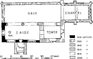
The Church of St. Nicholas, Oddington
The chancel, which is buttressed, has three separate cinquefoil lights, flanked by a pair of cinquefoil niches, in the east wall, and two tall lancets, with square-headed reveals, in each side wall. Below the windows internally is a string-course. The chancel arch and the south arcade of the nave are 13th-century, but the arch opening on the tower is of three orders whereas the chancel arch and the two opening on the aisle are of two. The arches to the aisle, moreover, are supported on a composite pier and responds with octagonal or semi-octagonal moulded capitals and bases with plinths, whereas the arch to the tower springs, at a lower level, from a half-round capital at the east side, and at the west side dies into the wall separating the tower from the aisle. The 15th-century west window is of three lights with tracery. The open timber roof of about the same date has a parapet round three sides. The north wall of the nave has a small rectangular window (apparently made in 1913) (fn. 283) at its extreme east end and a 15th-century north doorway, the lower part blocked and the upper part glazed; the western half of the wall is painted with the late 14thcentury doom, 'one of the most notable representations of the Last Judgement now surviving in the country'. (fn. 284) By 1960 decay had made it less clear. (fn. 285) Traces of other mural decoration survive in the chancel and tower, and on the arcade.
The simple 12th-century door of the south aisle is flanked by a pair of 14th-century windows of three lights with reticulated tracery; high up in the west wall is a lancet. There is an external string-course round the west end. A coved plaster ceiling hides the timbers of the roof, which is higher and steeper than that of the nave and has no parapet. On the west gable-end an older roof line can be seen, which shows that the roof was once rather lower, its pitch steeper, and its axis further to the north. The 13th-century archway from the aisle to the tower has been filled with masonry (to help to support the tower) leaving only a narrow round-headed entrance. The lancet in the east wall of the lowest stage is slightly north of the axis of the tower and aisle, and may be in line with the old ridge marked on the gable-end. The 14th-century window of two lights with reticulated tracery in the south wall of the tower was once a low side window, and in the east wall is a plain 13thcentury piscina, indicating that the base of the tower was used as a chapel. Possibly it was once the chancel, or was built on the foundations of the chancel. It is wider east to west than north to south, and while externally it is the same width as the aisle, internally it is narrower, the difference being more noticeable in the south wall than in the north. The walls of the tower, which has no buttresses, are nearly 4 ft. thick. Possibly the tower was placed in its unusual position simply because, with the building of a new chancel, the former chancel provided a good base. The second stage of the tower, which is not marked by a string-course, has a lancet on each face, that on the west being mostly obscured by the roof. The top stage, embattled and with gargoyles, was built in the 15th century and has a two-light window on each face.
The 14th-century porch has a dripmould over its arch and three scratch dials on its western jamb. (fn. 286) The 15th-century font is octagonal with sculptured faces to the bowl, chamfer, and pedestal. (fn. 287) Some ancient painted glass is said to have been destroyed in the 1640's. (fn. 288) The Jacobean pulpit and sounding board, standing against the north wall of the nave, are richly carved in oak and stand on a turned pedestal. (fn. 289) The altar table also is 17th-century, the Communion rails 18th-century. An oak bench with carved ends, possibly of the 15th century, stands in the tower. The arms of William IV are painted on plaster over the chancel arch, those of Victoria on canvas on the west wall of the nave. Of the hatchments hanging in the church in the 18th century (fn. 290) only two, both of Reade impaling Hoskyns, remained in 1960. A charity board on the west wall of the nave has only one entry. In the chancel are, among others, monuments to Thomas Chamberlayne (d. 1640), his son Thomas (d. 1689), and the son's wife Katherine (d. 1683), daughter of Robert Brent. (fn. 291) In 1960 there were five bells, which had not been rung for 30 years. (fn. 292) There were six bells c. 1700, (fn. 293) presumably including the three surviving bells, one of which bears the name of Abraham Rudhall, dated 1684, the earliest year in which Rudhall is known to have made bells. Of the other two, one is dated 1738 and one is by William Bagley (fn. 294) (fl. c. 1700). (fn. 295)
The church of THE ASCENSION, built in 1852, (fn. 296) is of stone in a 13th-century style, and comprises a chancel, a nave of four bays, a north aisle, and a north porch surmounted by a bellcot containing a clock and one bell. A turret over the chancel arch contains two other bells. The organ was built in 1854. (fn. 297)
A silver chalice and paten-cover were acquired in 1641, and in 1683 the parish had also a great flagon, apparently of silver. In 1733 a new bowl was put on the stem of the chalice, and in 1906 there was also a paten-cover of 1726 and a pyx of 1895. (fn. 298) Of these only the chalice remained in 1942; the paten-cover of 1726 has been made into a paten and in 1960 was in regular use. (fn. 299) There is a register of baptisms, marriages, and burials for 1549–1618, which is continued to 1674 by fragments on loose paper; registers for burials and baptisms continue from 1676, for marriages from 1685.
Nonconformity.
Several of the inhabitants of Oddington were fined under the Conventicles Act of 1664. (fn. 300) William Tray, the ejected minister of Oddington who had set up a school, secured a licence for his house as a Congregational meeting place, and although Tray did not remain long in Oddington, William Baker's house there was licensed for the same purpose a few weeks after Tray's. (fn. 301) In 1676 the population was said to include 14 nonconformists. (fn. 302) Richard Haydon's house in Oddington was licensed in 1707 as a Quaker meeting, (fn. 303) there were two papists c. 1720, (fn. 304) and in 1735 one papist, 10 Baptists, and 20 'Sabbatarians and congregationalists'. (fn. 305) Two families of Quakers, perhaps to be associated with the 'Sabbatarians and congregationalists', were enumerated in 1750, in addition to 10 Baptists. (fn. 306) A meeting of unknown denomination was registered in 1798. (fn. 307) In 1818 the Baptist minister of Stow and Naunton died at Oddington, (fn. 308) and in 1823 the Baptists registered a room there as a meeting. (fn. 309) In the mid-19th century Baptist clergy visiting Stow were lodged at Oddington, (fn. 310) and in 1845 a house was registered as, apparently, a Baptist meeting. (fn. 311) In 1851, however, there was no nonconformist chapel. (fn. 312) A Congregational chapel in Upper Oddington, near Fern Bank, existed from 1884 or earlier until after 1900. (fn. 313) In 1903 a Methodist chapel was built on the green at the lower end of Upper Oddington, (fn. 314) on the initiative of a small group headed by George Kempson, a farmer of Oddington, who had suddenly withdrawn his support from the parish church. By 1937 the chapel had fallen into disuse, and was sold for conversion into a house. (fn. 315)
Schools.
It has not been discovered whether or not the dissenter William Tray's school, in the 1660's or 70's, was in Oddington. In 1819 there were said to be three small schools for little children, where 40 children received education apparently at their parents' expense. (fn. 316) In 1825 only 15 of the children attended day school in the village, the rest attending Sunday schools, (fn. 317) which in 1835 were supported by subscription and were separate for boys and girls. There were in 1835 five day schools, supported partly by subscription and partly by fees, with a total attendance of 56. (fn. 318) The most popular of the day schools was held, probably with the support of Lady Reade, (fn. 319) in Manor Farm until 1844 when Sir John Chandos Reade required the house and a new school was built on the other side of the road roughly half-way between the upper and lower villages. A teacher's house was built in 1846 and an infants' classroom added in 1867. (fn. 320) By 1847 the school was in union with the National Society, (fn. 321) and from 1850 it had a master and a mistress and received an annual state grant. (fn. 322) In 1871 this was the only elementary school in the parish. (fn. 323) Attendance rose from 36 in 1847 (fn. 324) to 63 in 1869, (fn. 325) and was 70 in 1906. (fn. 326) In 1952 the school became controlled, and in 1960, when the older children of the village went to Moreton-in-Marsh, attendance was about 30, (fn. 327) compared with 50 in 1938. (fn. 328)
Charities.
In 1787 the inclosure commissioners allotted just over 2 a. in trust for the poor in lieu of their right to cut furze. One of the four allotments made to the surveyors (fn. 329) seems also to have been converted to the use of the poor, for 40 years later there was distributed in coal the rent from 4 a. said to have been allotted to the poor. Joseph Hervey, by will dated 1812, gave £100 in trust for the poor, (fn. 330) and William Lyne, by will proved 1877, gave a sum invested in £142 stock. In 1952 the interest and rent from all these endowments was distributed among 24 recipients in the form of cash vouchers for groceries worth £19 13s. 6d. in all. In addition the rent from 1 a. allotted in 1787 to the constable was distributed in the form of food parcels. (fn. 331)