A History of the County of Gloucester: Volume 6. Originally published by Victoria County History, London, 1965.
This free content was digitised by double rekeying. All rights reserved.
'Parishes: Stow-on-the-Wold', in A History of the County of Gloucester: Volume 6, ed. C R Elrington (London, 1965), British History Online https://www.british-history.ac.uk/vch/glos/vol6/pp142-165 [accessed 1 May 2025].
'Parishes: Stow-on-the-Wold', in A History of the County of Gloucester: Volume 6. Edited by C R Elrington (London, 1965), British History Online, accessed May 1, 2025, https://www.british-history.ac.uk/vch/glos/vol6/pp142-165.
"Parishes: Stow-on-the-Wold". A History of the County of Gloucester: Volume 6. Ed. C R Elrington (London, 1965), British History Online. Web. 1 May 2025. https://www.british-history.ac.uk/vch/glos/vol6/pp142-165.
In this section
STOW-ON-THE-WOLD
Stow-on-the-Wold, anciently called Stow St. Edward or Edwardstow, is a former market town lying on the Foss Way 19 miles north-east of Cirencester, and is the centre of the ancient parish, 2,960 a. in area, (fn. 1) that bears its name. For several centuries up to 1894 the ancient parish was divided administratively into three parts, namely, the town of Stow and the hamlets of Maugersbury and Donnington. (fn. 2) The town itself, covering only 33 a. until 1894, stands against the east side of the Foss Way where the road tops a prominent hill above the 750-ft. level, and can be seen for many miles around. (fn. 3) At the summit the Foss Way crosses the old Cotswold Ridgeway, and meets the Evesham–Burford road (running with it for a mile) which may be an ancient saltway leading from Droitwich. (fn. 4) Another road, from Tewkesbury, joins these three routes where they cross. The town is built largely in the north-east angle between the Foss Way and the Cotswold Ridgeway.
East and south of the town lies Maugersbury, 1,875 a. in area and compact in shape. The boundary runs south from Stow for a mile along the Foss Way to the junction with the Burford road. There it turns west to the River Dikler which it follows (fn. 5) down to Stow Bridge on the Foss Way. It then runs in a rough semicircle, east, north, and west, back to the northeast corner of the town. (fn. 6) Donnington is detached from the rest of the ancient parish, lying about a mile north of it. The area of the hamlet, 1,052 a., is unusually long and narrow in shape, stretching from the River Evenlode in the east to a mile west of the River Dikler—over 4 miles long with a breadth never more than ½ mile. The north boundary at its west end follows a minor road for 2 miles, and the south boundary follows the Foss Way for 800 yds. (fn. 7) The elongated shape of Donnington is probably to be explained by its being a sort of no-man's land, a remote strip omitted from the surrounding parishes until a late stage in the arrangement of boundaries. It was presumably because of the need to increase the value of the benefice of Stow, perhaps at a time when the obligations of its incumbent were expanding with the growth of the market town, that Donnington became part of Stow parish, which it did not adjoin, rather than of Broadwell. Evesham Abbey was lord of all three, but Donnington's tenurial connexion with Broadwell was closer. (fn. 8) It may have been thought that Broadwell parish, including the chapelry of Adlestrop, was already large enough.
The boundaries of the town until 1894 followed Well Lane and the lane leading from it to High Street, High Street to the junction with the Foss Way (i.e. north of where the fountain stands), the east side of the Foss Way, (fn. 9) Back Walls, and (approximately) Union Street. (fn. 10) In 1894 the boundaries were rationalized by transferring to Stow from Maugersbury 12 a. on the east side of the town into which the urban area had spread, (fn. 11) and further enlargements came in 1923 (31 a. from Maugersbury and 11 a. from Lower Swell), 1935 (71 a. from Broadwell, 21 a. from Maugersbury, 107 a. from Lower Swell, and 24 a. from Upper Swell), and 1938 (18 a. from Maugers- bury). (fn. 12) Thus the area of the civil parish of Stow was extended in every direction and in 1961 was 328 a.
The land of the ancient parish is generally hilly and the only flat parts are in the south-west of Maugersbury by the Dikler and the east end of Donnington by the Evenlode. South from Stow the hill runs down to a saddle with streams draining east (the Hedbrook or Edenbrook, which provided fishing in the 10th and 16th centuries) (fn. 13) and south-west (the Fulbrook), (fn. 14) to join the Evenlode and Dikler respectively. Beyond these streams the land slopes steeply up the sides of Icomb Hill. East from Stow the hill stretches out a shoulder into the Evenlode valley. The Lias of the lower ground is overlain by the Lower Oolite and Chipping Norton Limestone where the land rises. (fn. 15) Below Stow on the east, south-east, and south, springs emerge where the Lower Oolite overlies the Upper Lias, and these have supplied the town wells of Stow, the village of Maugersbury, and St. Edward's Well by the Foss Way. (fn. 16)
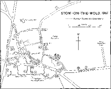
Stow-on-the-Wold, 1961
1. Lower well
2. Upper well
3. Drinking fountain, site of
horse pool
4. Police station, site of the
'George'
5. Stocks
6. Site of Friends' meeting
house
7. St. Edward's Hall
8. Former National school
9. Oddfellows Row
10. Ebenezer chapel
11. St. Edward's House
12. Site of Court House
13. Site of Cross House
14. Cross
15. The 'King's Arms'
16. The 'Unicorn'
17. Almshouses
18. Masonic Hall, former grammar school
19. The 'Talbot'
20. Old malthouse
21. Methodist church
22. Porch House
23. Hewitt gardens
24. East View, former Union
workhouse
25. Junior school
26. Cotswold House, formerly
the 'Crown'
27. Raggs Row
28. Old masonic hall
29. Baptist church
30. Roman Catholic church,
formerly the Beale Brown
school
31. Former brewery
32. Toll house
33. Bell Inn
34. Gas works
35. Maugersbury park lodge
36. Enoch's Tower
37. Infants' school
In Maugersbury there is not much woodland, but the largest piece, Maugersbury Grove which faces Stow from the slopes of Icomb Hill, existed in the 16th century. (fn. 17) The open fields of the hamlet covered almost all the uninclosed land. The woodland beside the Foss Way on the hill up to Stow was apparently planted by the rector, after inclosure, in the late 18th century. (fn. 18) Adjoining the town to the south-east is the park that once belonged to Maugersbury manor, which was apparently created by the 16th century (fn. 19) and has given a name to a street in Stow and to a 20th-century housing estate.
In Donnington the land rises from about 400 ft. in the Evenlode valley to 700 ft. in the middle of the hamlet before dipping down and up again across the steep valley of the Dikler. From east to west there is a regular succession of geological formations: Boulder Clay by the Evenlode; Lower, Middle, and Upper Lias, and Lower Oolite; and Chipping Norton Limestone on the west side of the Dikler. (fn. 20) Where it enters Donnington the Dikler emerges from an underground course and forms an artificial lake of nearly 5 a. above Donnington Mill. A stream runs into the Evenlode through the east part of the hamlet, passing Crawthorne Wood which is over 40 a. and the only large piece of woodland. Until inclosure in 1765 much of the higher ground is likely to have been rough grazing with the arable land concentrated in the east.
The primary settlement of the parish seems to be Maugersbury village rather than Stow itself. First, it is unlikely that the town of Stow would have been so much in a corner of the parish, and, particularly, to one side of the Foss Way and bounded by it, unless the boundary (of which the road formed part) was fixed before the town was founded. Secondly, the earthwork from which Maugersbury took its name is actually part of the site on which the town stands. (fn. 21) Thirdly, the pre-Conquest charters, which imply the existence of a settlement, make no mention of the town although it is on the boundaries that they describe. (fn. 22) Fourthly, the site of the town lacks amenities for an agricultural settlement, and its advantages as a commercial site indicate that it was founded as a market in an age of commercial activity, not in one of primary settlement. Lastly, it would be unusual for Maugersbury to be sited only ½ mile from Stow if Stow existed already. The site of the town has, however, a record of settlement from prehistoric times. Neolithic axes have been found there, (fn. 23) and Maethelgeres Byrig, the earthwork referred to above, was a pre-Roman hill-fort that later became the north-west corner of the town, (fn. 24) where Romano-British and early Saxon remains have been unearthed. (fn. 25)
The siting and layout of the town round a wide market square suggest a considered attempt by the lords of the land, Evesham Abbey, to exploit the commercial possibilities of a major road junction. The attempt probably began in the mid-11th century. The royal grant of a market in 1107 accords with this, (fn. 26) and the town was established by 1086. (fn. 27) In the absence of evidence that there was ever a church at Maugersbury, the founding of the town may have been contemporary with the provision of a church in the 11th century. (fn. 28) The relative positions of the church, market square, and main roads suggest that the church was built before the square, but not necessarily before the market was established.
The town evidently prospered in the 12th century, towards the end of which Walter of Clifford son of Richard was persuaded to demolish houses close to the town on the other side of the Foss Way: they had been built with the purpose of exploiting the commercial advantages that Evesham Abbey's town was intended to enjoy. (fn. 29) By the end of the 13th century the size and prosperity of the town were indicated by the number of ordinands it produced, (fn. 30) and the tax returns for 1327, which show Stow, with 27 taxpayers, as not much larger than Maugersbury and as smaller than Sherborne in numbers and than Mickleton in numbers and wealth, (fn. 31) seem to be misleading as a guide to population. From 1357 Stow was important enough to supply frequently a collector of taxes for the county, (fn. 32) though in 1381 only 166 people were assessed for poll tax. (fn. 33)
To judge from population figures Stow, in the middle of the wool-producing Cotswolds, grew during the 15th century, (fn. 34) and this is corroborated by the grant in the late 15th century of two annual fairs in place of one. (fn. 35) In the later 16th century the decline, or at least stagnation, suggested by the very small number of male inhabitants listed (there were only 74) in 1608 is belied by the figure of 400 communicants returned for the whole parish in 1603. (fn. 36) A marked growth again in the earlier 17th century is shown by the figure of 252 houses in 1671, (fn. 37) and partly explains the protracted struggle for control of the town between the lord of the manor and the burgesses. (fn. 38) In 1675 Stow was described as a large though poor town, (fn. 39) and a hundred years later it was said to be indifferent to look at, with the suggestion that it had passed its prime. (fn. 40) The population may then have been slowly declining. (fn. 41)
At the beginning of the 19th century the opening of a spa at Lower Swell little more than ½ mile from the town (fn. 42) brought hope of a great increase in fortune: like many other places Stow thought to emulate Clifton and Cheltenham. (fn. 43) There is no evidence that it achieved its aim, and its growth in the earlier 19th century (the population of the town rose to 1,515 in 1851) (fn. 44) apparently followed from the relative prosperity of agriculture in general, the success of the local boot and shoe trade, (fn. 45) and the wealth brought to the town through its inns from increasing road traffic. (fn. 46) Migration to the large manufacturing towns was said in 1861 (fn. 47) to be responsible for a decline in population that continued until at least 1931, apparent increases being achieved only by the addition of urbanized parts of Maugersbury to the administrative area of Stow. (fn. 48) From 1931, however, the population has risen through the building of a large number of houses by the rural district council. As a result Stow in 1961 was to a considerable extent a dormitory town, its inhabitants going daily to work elsewhere, mostly in Cheltenham, Witney, and Oxford. (fn. 49) The picturesque features of the older part of the town have attracted both retired people as residents and holiday tourists.
The town was originally built round a market square in the form of an elongated rectangle, with one of its longer sides against the churchyard and with streets leading from three corners to the main roads. The through routes may have been diverted along these streets and through the square. A map of 1675 shows the main north-south route leaving the Foss Way to go along High Street, through the square, and out along Church Street. (fn. 50) In the Middle Ages the main east-west route seems to have gone by Digbeth Street and Church Street rather than straight along Sheep Street, for Sheep Street was called the new street in 1457 (fn. 51) although each end of Sheep Street existed with buildings along it much earlier. (fn. 52) Digbeth Street and Church Street are likely once to have been much wider: their shapes suggest it, and encroachments by porches, penthouses, and palings were exploited in the early 18th century as a source of manorial profit. (fn. 53)
The market square suffered continual encroachment. By the 16th century the Court House or Town House stood in its south-east corner, and in the middle of its southern half were the 15th-century market cross and the Cross House. It has been suggested that the Court House had 13th- or 14thcentury origins; (fn. 54) it was used for holding the courts (fn. 55) and perhaps also in connexion with the market and fairs. The Cross House was apparently used for storage of hurdles and other market equipment. (fn. 56) Both subsequently became shops. (fn. 57) The Cross House was enlarged c. 1700; (fn. 58) by the early 17th century a row of houses extended northwards from the Court House; and soon afterwards there was another row on the other side of the square, so that only the northern half and the south-east corner were left open. The southern half of the square contains, on the whole, the larger houses, and it was mostly these that by 1961 had been converted to shops and business premises.
The first steps, in 1878, towards tidying the square were the restoration of the cross in memory of Joseph Chamberlayne Chamberlayne and the building of St. Edward's Hall. The cross had been headless in the early 19th century (fn. 59) and later had been used as a lamp standard. (fn. 60) The hall, built partly by subscription and partly out of unclaimed money from the Stow Provident Bank, was designed in a typical Victorian Gothic style 'to harmonize with the Tudor buildings of the district' by Medland of Gloucester, and replaced a number of miscellaneous buildings. It soon became the centre for social functions and local government meetings, and the home of the town's library and reading room and of an artgallery and museum. (fn. 61) In 1901 the Court House was demolished and replaced by a new shop building; (fn. 62) and c. 1930 the Cross House and the adjoining building were removed, (fn. 63) to open up the southern end of the square. The north part of the square in 1961 was, where not made-up road, well-kept grass, with elm trees and the stocks beneath them.
North-west from the square, where the High Street joins the Foss Way, there was by the early 16th century a horse pool, which was filled in in 1895 and replaced by a drinking fountain and drinking troughs. (fn. 64) Five years later the broad space southeast from the square, where Digbeth Street meets Sheep Street (apparently the Old Greenhill mentioned c. 1668), (fn. 65) was enclosed and presented to the town as a garden by the lord of the manor. (fn. 66) Leading off the square are several narrow lanes or 'tures'; (fn. 67) according to local tradition they were designed to help in counting sheep leaving market, but it is more likely that as in other towns they were built to give access to dwellings (many of which have been demolished or converted into outbuildings) built behind the houses that front the square, to provide more housing without laying out new streets.
When the town needed to extend outwards instead of becoming more concentrated by infilling, the direction was first south across New Street or Sheep Street (alternatively known as Back Street c. 1600) (fn. 68) to the street called Back Walls that for long enclosed the town on the south side; then, in the 17th century, south-east along Park Street to give the town the shape on which the administrative boundaries were fixed until 1894. (fn. 69) Later the main area of new building was east of Well Lane, in Maugersbury's territory, and nearly 100 small houses were built there in the earlier 19th century. (fn. 70) The same period saw also the building of the Union Workhouse in 1836, (fn. 71) after which Union Street is called; the workhouse was remodelled after 1929, and later became an old people's hospital known as East View. (fn. 72) This north-east part of the town was for a long time devoted to allotment gardens, (fn. 73) some of them on the glebe which gave a name to Parson's Corner, and, where not built over, much of the land was still so used in 1961. Quarries and limepits there were in use by the 19th century. (fn. 74)
The Crescent, Maugersbury
In the next period of expansion, the 1930's, the town stretched east again when the rural district council built the large estate known as King George's Field; there was also some building south of the town beyond Back Walls and on the west, beyond the Foss Way in what was formerly Lower Swell parish. In the fifties infilling brought the number of houses in King George's Field to nearly a hundred, and the rural. district council began another large estate, known as the Park, south of Back Walls. In 1961 there were about 50 houses there, and more were being built.
A tradition that Stow was once a walled town seems to rest on the doubtful evidence of the streetname Back Walls. The landscape does suggest, however, that there was some sort of enclosure running round the east and north-east sides of the town and perhaps continuing along Back Walls; and this suggestion is strengthened by a reference in 1549 to land in Maugersbury 'under the wall of Stow'. (fn. 75) The wall may have been more for definition than for defence, but it is also possible that the suggested line is an outwork connected with the prehistoric hill-fort already mentioned; (fn. 76) the area east of Well Lane was known in the 18th century as the Camp. (fn. 77)
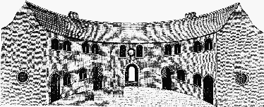
Only ½ mile south-east from the centre of the town, Maugersbury village lies on a south-facing slope nearly 200 ft. above the bottom of the valley it overlooks. The village seems to have been built round the upper end of a green that stretched down towards the stream in the valley. (fn. 78) Two large upright stones in fields south of the village may once have marked the green's edges. Inclosure in 1766 and subsequent rebuilding has reorientated the village so that it now focuses partly on a group of larger houses near the road leading to the manor-house on the edge of the park that separates Maugersbury and Stow, partly on the point at the top of the village where roads from the Foss Way, from Stow (called Churchway in 1506), (fn. 79) from Oddington, and from Icomb (this road has become little more than a footpath on Icomb Hill) all meet. The cottages and smaller houses of the village were mostly rebuilt c. 1800 through the efforts of the lord of the manor, Edmund John Chamberlayne, (fn. 80) who seems to have intended to make Maugersbury (in a modest way) a 'model' village, of which the most striking survival is the Crescent, a semi-circular building with an internal diameter of 48 ft. containing 4 small cottages and a schoolroom. (fn. 81) The village appears to have changed little in size between 1327 and 1931, for it had from 20 to 30 families or households in 1327, (fn. 82) 1381, (fn. 83) 1608, (fn. 84) 1671, (fn. 85) 1821, and 1931. (fn. 86) The building of new houses before and after the Second World War and the conversion of barns and stables have increased the size of the village by about half.
Near the bottom of the valley and on the far side from the village are the post-inclosure farm buildings of Oxleaze, and a large house and extensive modern dairy and poultry houses built in the 1950's. Beyond them, near where the Burford road enters Wick Rissington parish, an entrance lodge and a gamekeeper's lodge for Wick Hill House were built in the 19th century on the part of the Wick Hill estate that was in Maugersbury. (fn. 87) Near them, also in Maugersbury, is Wick Hill Farm, formerly Reynold's Barn. (fn. 88) In the part of Maugersbury between the Foss Way and the River Dikler (the area known since the 11th century as the Hide) (fn. 89) are Hide Mill, which was largely rebuilt in the 20th century, and Hide Farm, built in the late 18th century. Further south is a small 19th-century farm-house, and near the Foss Way is the Fosse Guest House (formerly Hyde House) which Henry Ingles Chamberlayne built for himself in 1900 when he sold the manor. (fn. 90) Near-by, in the angle between the Foss Way and the Burford road, is an 18th-century inn, the 'Farmer's Arms', presumably the ale-house for which a recognizance was taken in 1755. (fn. 91)
North of the 'Farmer's Arms' and east of the Foss Way is the Retreat, pleasure gardens made c. 1800 to include the spring known as St. Edward's Well. The gardens appear to have been used in connexion with the attempt to popularize Stow as a resort; a wooded walk leads down the hill from the town, passing under the road from the Foss Way to Maugersbury village by a bridge that has given that road the name of the Arches. (fn. 92) The spring, known variously as Holy Well and St. Edward's Well in 1766, (fn. 93) was reputedly beneficial to weak eyes. Beside it was a typically Romantic grotto, and nearby was a pair of cottages, the southern one Gothic, and the other classical, stuccoed, and with a Venetian window and pedimented gable-end, where refreshments were provided. (fn. 94) The Retreat was part of the glebe, and it was restored in the early 20th century by the rector; (fn. 95) in 1961, however, the gardens were derelict and the buildings ruinous.
The small and compact village of Donnington has a remote site, 1½ mile north of Stow and ¼ mile west of the Foss Way, at the 600-ft. level near the top of the eastern slope of the ridge between the Dikler and the Evenlode. It lies in a slight fold in the ground and is therefore more sheltered than it seems at first sight to be. The 'square of Donnington' with a watercourse running through it, referred to in the 17th century, (fn. 96) can be identified with the north-east corner of the village. The smithy that stood west of it from 1614 until the early 20th century was described in 1640 as being on the edge of the green at the town's end near the highway. (fn. 97) Soon afterwards the village stretched up the hill to where the road comes in from the southwest, and this road was linked to that from the southeast by a road that seems originally intended to give access to the back gardens of houses on the village street. This extension of the village seems to have accompanied a growth in population that may have been stimulated by the enfranchisement of the copyholders in the late 16th century, (fn. 98) for whereas the hamlet comprised about a dozen households in 1327, (fn. 99) 1381, (fn. 100) and 1608, (fn. 101) by 1671 the number of houses had risen to 28. (fn. 102) It was still the same in 1801, and although the population and the village grew in the earlier 19th century they had fallen right back by 1891 and remained there until the 1930's, when the population was lower than in 1801. (fn. 103) From the 1930's there was some new building on the edge of the village, and the village's rural appeal and convenience for fox-hunting began to attract new residents. These changes transformed its character, though its appearance survived.
Donnington Manor, immediately north of the village, was built in the 18th century perhaps on the site of an earlier house. At Donnington Mill there is a row of former cottages in addition to the mill house, and in 1919 the owner of the mill built for himself Duncombe House, ¼ mile east of the mill. (fn. 104) Little Barrow, a large house east of the Foss Way, was built c. 1800 and later considerably altered, and has a group of mid-20th-century houses near-by. Heath Hill, Lemell Hooks, Waterhead, and Weasel Barns are isolated groups of buildings built after the inclosure of Donnington in 1765. (fn. 105) South of the village is the main reservoir for the rural district council's water supply.
Building in the parish of Stow was predominantly of stone from the late 16th century to the 20th, and stone walls in the streets and alleys of the town are a characteristic feature. The houses there, and particularly those grouped round the square, provide an attraction to sightseers. In the mid-16th century a ruling of Maugersbury manor court about treeplanting indicates that timber was still thought to be important for building, (fn. 106) and in the same period there were references to thatched roofs and timber and wattle barns. (fn. 107) In 1499 the stone wall of a grange is mentioned as though it were an isolated example. (fn. 108) By the end of the 16th century stone seems to have been the most frequently used material, perhaps partly because of a shortage of timber. In the square and the older streets of the town nearly all the houses are of the 17th and 18th centuries, and several 17th-century houses on the west side of the square had extensions built at the front in the 18th century. Many houses have moulded hoods of stone or wood over their front doors. Welsh slate roofs are more common in the town than in the two villages, where Cotswold stone roofs predominate. Donnington has a high proportion of 17th- and 18th-century cottages in the traditional local style. In Maugersbury all the smaller houses are of c. 1800 or later. (fn. 109) The only extensive use of brick in the parish is in the council houses built in the 1930's; for the later houses, in the Park, stone was once again used. In the 1950's consciousness of local materials was apparently responsible for the removal of roughcast from the rubble front of one house in the town and for the replacement of Welsh slate by Cotswold stone on the roofs of others. (fn. 110)
Of the more noteworthy individual buildings in the town, the Masonic Hall (formerly the grammar school), built in 1594, (fn. 111) has two stories and is of rubble with a Cotswold stone roof. There is a small inscribed tablet on the centre of the front. The windows are of six and three lights, each light with an arched head. A house of the same period in Digbeth Street has an arched stone doorway and mullioned windows, one with four lights and a dripmould. On the opposite side of the street is a former malthouse (fn. 112) from which it appears that the moulded 13th-century doorway at Maugersbury Manor was removed in 1865. (fn. 113) This property was probably the one called Sandford's Great Place, after the 16th-century owners. (fn. 114) The Porch House and the adjoining house, at the bottom of Digbeth Street, form together one house built in the 15th or early 16th century. On quite inconclusive evidence it is reputed to have been 'Ethelmar's Hospital'. (fn. 115) It represents an unusual survival in the area of a timber-framed building. It was altered in 1615 when it was given a two-storied porch of ashlar. (fn. 116) The rebuilding of the front wall in rubble and the insertion of stone fireplaces may be of the same date. The back wall is of close-studded timber-framing, and the contemporary roof of five bays has an open arch-braced collar-beam truss between the two eastern bays. The building was later altered, perhaps in connexion with its use as an inn, the 'Eagle and Child', in the 18th century, (fn. 117) and was afterwards divided into two houses.
The 'King's Arms' in the square and the building next to it have three-storied 17th-century fronts with mullioned and transomed windows; at one end of the range there are boldly projecting eaves, and at the other four gables, with moulded copings and finials, pierced by small oval lights. St. Edward's House, the most elaborately decorated in the square, has an unusual enriched facade of the early 18th century, with fluted Corinthian pilasters to its full height of three stories; it is said to have been carved by a local shepherd, (fn. 118) perhaps from a confused association with a pargeter named Shepherd who was living in Stow at about the period it was built. (fn. 119) On the main road leading east out of Stow is a hexagonal tollhouse, apparently of the late 18th century, which is built of stone and has a Cotswold stone roof with finial. Beyond it Enoch's Tower, four stages high and castellated, was built in 1848 to serve as a private museum. (fn. 120)
Maugersbury Manor is a large three-storied Lshaped house of rubble with a Cotswold stone roof. The house has been altered at several dates, and it may be on the site of Evesham Abbey's house in Maugersbury mentioned in 1402. (fn. 121) It is likely, however, that a completely new house was begun in the later 16th century, for a lease of the manor in 1568 provided that the tenant should build a house at least 36 ft. by 18 ft. From 1658 the house was greatly enlarged, (fn. 122) and the building of this period is most of what remained in 1961. The three-storied porch in the middle of the south wing, facing west, is entered through the 13th-century doorway removed in the 19th century from the house in Stow mentioned above. In the 18th century the house was altered, the roof raised, and segment-shaped windows inserted under the eaves to replace the earlier gables. Sash windows were also inserted in place of the large twostoried window of the hall. (fn. 123) On the south side of the north-west wing are two massive buttresses with 18th- or 19th-century panelling.
In Maugersbury there are six 17th-century farmhouses, all of rubble with Cotswold stone roofs. Park Farm, Rock House, and Manor Farm appear to have been built each as two separate farm-houses, while Dower House and Sycamore Farm are rather larger. All have mullioned windows, but only Park Farm and Manor Farm have dripmoulds. Manor Farm, which is apparently late 17th-century, has transoms also. The Crescent, built in 1800, has been mentioned above. (fn. 124)
Donnington Manor, which is of rubble with a Cotswold stone roof, retains some of its 18th-century fabric but the north-east front was remodelled in the early 19th century and the south end of the house was completely rebuilt (fn. 125) in the 20th. The house is of two stories, with a parapet and dormers. Some of the mullions and transoms are of wood.
The main roads passing through the parish and the more important of the local roads have already been mentioned. The lane leading to Hide Mill, called Foss Lane in 1766, (fn. 126) existed before the Conquest, when there was a ford near the mill, (fn. 127) and the lane leading due south from Donnington to the Foss Way was the main route between Donnington and Stow until the mid-19th century. (fn. 128) The one important bridge in the parish is Stow Bridge in the south-west corner where the Foss Way crosses the Dikler, and the bridge there had by 1623 given a name to Foss Bridge close. (fn. 129) The bridge was widened in the 20th century, but on the upstream side the low rounded arch seems to survive from the 18th-century bridge. The Foss Way and the Cotswold Ridgeway were turnpiked on each side of Stow in 1755, (fn. 130) the road to Evesham in 1757, (fn. 131) that to Burford in 1770, (fn. 132) and that to Tewkesbury in 1794. (fn. 133) When the Oxford, Worcester, and Wolverhampton Railway was built alongside the Evenlode in 1853 (but not passing through the parish) a station to serve Stow was sited by Adlestrop Bridge, 3 miles down the main road. (fn. 134) The opening of the Bourton-on-the-Water Railway through Maugersbury in 1862 (fn. 135) enabled Stow to have a station only a mile away, though on a minor line. The nearest main stations are Moreton-inMarsh and Kingham (Oxon.).
The importance to Stow of its position at a major road junction is most immediately shown through the number of its inns, which has given rise to the local tradition that every house facing on the square was an inn or at least sold drink during markets and fairs. In 1381 brewing or innkeeping seems to have been the largest single trade in the town: 8 taxpayers were described as brewers, one as a taverner, and one as an innkeeper (hostellarius). (fn. 136) In 1635 there were at least 15 ale-house keepers in the town, (fn. 137) in 1735 the 'convenient inns' were thought worthy of mention, (fn. 138) and in 1755 there were 29 ale-house keepers. (fn. 139) A brewery in the town survived into the 20th century, (fn. 140) and the 19th-century brewery at Donnington Mill flourished as an independent business in 1961. (fn. 141)
The earliest known inn was the 'Swan' in Sheep Street, which existed by that name in 1446 (fn. 142) and ceased to be an inn c. 1700. (fn. 143) The 'Crown', also in Sheep Street, was recorded in 1499; (fn. 144) it apparently became c. 1740 a private house, the Crown House (fn. 145) later called Cotswold House, (fn. 146) which was rebuilt about that time and altered later. Four doors down from the 'Crown' in 1499 was the 'Bell', (fn. 147) but by 1706 another house, at the north end of Church Street and formerly known as the Ringed Hall, (fn. 148) was an inn called the 'Bell'. (fn. 149) A third inn of the same name, formerly the 'Royal Oak', was in 1767 on the site occupied by the Bell House (not an inn) in 1608 and by the modern building of the Bell Inn in 1961. (fn. 150) Another medieval inn, the 'George', in the square, belonged to the Holy Trinity Guild in 1511 (fn. 151) and survived until 1866 when it was demolished to make way for the police station. (fn. 152)
Three inns recorded in the 17th century remained inns in 1961. The 'King's Arms', in an early 17thcentury building that was an inn by 1666 (fn. 153) and perhaps by 1647, (fn. 154) was at one time reputed the best inn between London and Worcester, (fn. 155) at which Robert Harley (later Earl of Oxford) chose to stay in 1708, (fn. 156) and whose name alone seems to underlie the traditions that it was licensed as a posting-house in 1548 and provided lodging for Charles I in 1645. (fn. 157) The 'Unicorn', in an 18th-century building but evidently deriving from the 'Apothecaries' Arms', an important inn in 1670, (fn. 158) sited at the junction of two main roads, had by the 19th century become the leading inn of the town. (fn. 159) The 'White Hart' was an established inn by 1698. (fn. 160) Two other 17th-century inns, the 'Mercers' Arms' and the 'Grocers' Arms', (fn. 161) have not been traced later. Inns first recorded in the early 18th century include the 'Bull' in the house called Sandford's Great Place, the 'Eagle and Child' in the Porch House, the 'Quart Pot', and the 'Bear' or 'Cross Keys' on the south side of the square, (fn. 162) none of which has been traced as an inn later than the 18th century. The 'Talbot' existed as an inn by 1714 (fn. 163) and in 1961 was the town's largest hotel. The 'Red Lion', established by 1774, (fn. 164) survived as a private hotel in 1961; the 'White Lion', the 'Butcher's Arms', the 'King's Head' on the east side of the square, and the 'Crown and Anchor' went out of business in the 19th century. (fn. 165) Although the declining importance of Stow as a market town and road-centre lowered the number of large inns after the mid-19th century, the tourist trade in the 20th helped to support the survivors and provided business for several guest-houses and private hotels.
Because the town was built on the crown of a hill, entirely above the spring line, water supply was liable to be a problem. The nearest springs, northeast of the town and lying in Broadwell parish, seem to have provided the town with water during most of its existence, and by the early 16th century had given a name to Well Lane. (fn. 166) It was probably one of these springs that had been repaired in 1563 when several people were in debt for the well timber. (fn. 167) In the late 17th century these springs were in poor condition, (fn. 168) and c. 1700 water was being brought by cart from the bottom of the hill in Lower Swell. (fn. 169) The springs in Broadwell were known as the Upper and Lower Wells or the White Pump and the Red Pump Wells. (fn. 170) They were used through the 18th century, though they were never satisfactory because they were over-used: the road to them was out of repair in 1744, (fn. 171) the Lower Well was fouled by washing pigs' guts in 1747, (fn. 172) the Upper Well was neither fenced nor covered in 1761, (fn. 173) and the water-carts were a nuisance when left in the streets at night. (fn. 174) In 1961 the Upper Well retained a large stone tank of some antiquity; the Lower Well had a smaller trough. About 1800 a system of pipes was laid from Lower Swell to Stow, the intention being to force the water uphill by means of a windmill in Lower Swell by the Foss Way. The windmill had to be replaced by a horse-mill, the wooden pipes rotted, (fn. 175) and in 1836 a new system was started by which a water-wheel pumped water to Stow from Upper Swell. This system was expensive and fallible; it had been abandoned by 1866 (fn. 176) and water carts and the Upper and Lower Wells were once more brought into use. In 1867 the vestry bought a well behind the police station and built the water-tower there, but the inadequacy of the supply caused bitter disputes until 1871, when Joseph Chamberlayne Chamberlayne, lord of the manor, gave £2,000 for the water supply and a deep well was dug; (fn. 177) in 1876 the waterworks were vested in the local board. (fn. 178) Maugersbury and Donnington were supplied by near-by springs; Maugersbury's supply was inadequate in 1905 and had to be supplemented. (fn. 179) Since 1937 the rural district council has supplied mains water. (fn. 180)
In sewage disposal the town's position offered advantages. Numerous cavities in the rock, known locally as swillies (which may be partly responsible for the multiplicity of local stories about underground passages), provided a system of natural soakaways that was supplemented by mains sewerage in 1958. (fn. 181) The Stow-on-the-Wold Gas and Coke Co. was established in 1860, (fn. 182) with works at the lower end of Back Walls, (fn. 183) and by 1930 had 4 miles of mains in service. (fn. 184) After nationalization mains were laid from Cheltenham and gas was brought from there to the gas-holder at Stow. (fn. 185) Mains electricity was available by 1939. (fn. 186) A post office was established in the town by 1839. (fn. 187) The fire brigade was started in 1874 by public subscription as a volunteer body with an engine house in the police station yard; (fn. 188) the fire station on the Foss Way was built in 1935. (fn. 189)
At the end of the 18th century several friendly societies were formed: those founded in 1787 (fn. 190) and 1794 (fn. 191) were probably as short-lived as most such societies, but that founded in 1799 lasted until 1829 and later. (fn. 192) In 1829 the Stow Lying-in Benefit Society was founded, and in 1893 a branch of the Cotswold Benefit Nursing Association was started in Stow. (fn. 193) More limited politically or socially were the Stow-on-the-Wold Tradesmen's Friendly Society founded in 1852, (fn. 194) the Stow-on-the-Wold New Union Society which was active from 1837 until at least 1865, (fn. 195) and the Stow branch of the Cirencester Working Men's Conservative Benefit Society, started in 1890. (fn. 196) At the end of the 19th century there were also a Girls' Friendly Society and a coal and clothing club. (fn. 197) A savings bank was started in 1816, (fn. 198) and its work was apparently carried on between 1849 and 1868 by the Stow Provident Bank. (fn. 199) A branch bank was established in Stow by 1888. (fn. 200) The Prince of Wales Lodge of Freemasons, founded in 1863, met first at the 'White Hart' and from 1869 in the flint building in Sheep Street in front of the brewery; at the end of the 19th century the old grammar school building was acquired as a masonic hall. (fn. 201) The Oddfellows' Loyal Cotswold Lodge was founded in 1867, meeting first at the 'King's Arms'. (fn. 202) The Stow branch of the British Legion in 1949 acquired as a hall the old building of the former National school in Well Lane. (fn. 203) The Little Wonder Lodge of the Independent Order of Good Templars was founded in 1853, and the Stow-on-the-Wold Band of Hope in 1873: it does not appear that drunkenness was ever particularly serious in Stow. (fn. 204) Of the clubs of less serious purpose the Cotswold Archery Club, which flourished from 1847 to 1879 at least, was the most ambitious, and its annual meetings at the 'Unicorn' (fn. 205) may have taken the place of the annual balls held there in the early 19th century as part of the attractions of a would-be spa town. (fn. 206) Later in the 19th century clubs were started for cricket, (fn. 207) football, quoits, and tennis; (fn. 208) the tennis club had its ground on the old bowling green across the Foss Way from the 'Unicorn'. (fn. 209) In 1894 a choral society was founded. (fn. 210) The lending library started by a Mr. Archer in 1811 (fn. 211) and the reading room that existed by 1856 (fn. 212) were moved into St. Edward's Hall on the completion of that building. (fn. 213) The most notable social institution in the town in the late 19th century was the company of Volunteers, originally raised in 1796, disbanded in 1814, and started again in 1860. The rifle range in Maugersbury, south of the village, was built for them, and they were the object of considerable local pride and support. (fn. 214)
At the end of 1642 a royalist force passed through Stow on its way to Cirencester; (fn. 215) this was the first of several military episodes at Stow during the Civil Wars. In the spring of 1643 parliamentary troops, in a sally from Gloucester, beat up the royalist quarters there, (fn. 216) and in the autumn Prince Rupert encountered the army marching to relieve Gloucester just short of Stow. (fn. 217) Next year Sir William Waller followed the king's retreat through Stow towards Worcester. (fn. 218) In 1645 Charles I stayed a night in Stow, (fn. 219) and at the end of the year a force of over 1,000 horse and foot quartered in Stow on its way to Worcester. (fn. 220) Early in 1646 Stow was the scene of the last battle of the first Civil War, when Sir William Brereton attacked a royalist force under Lord Astley just before it passed through the town on its way south. Over 1,600 prisoners were taken, and were held for the time being in Stow church, (fn. 221) and it was at Stow that Astley gave his often quoted advice to his captors. (fn. 222) These events disrupted local life: the bailiffs and burgesses of the town abandoned their meetings in 1644 and 1645; (fn. 223) the lord of the manor received nothing from the fairs in 1643 and 1644, and very little in 1645; (fn. 224) and in addition the entertainment of officers on both sides was expensive. (fn. 225)
The effects of the fighting were made worse by visitations of plague in 1644 (fn. 226) and 1646. (fn. 227) Smallpox was said to be rife in Stow in 1758, though the churchwardens denied it. (fn. 228) There were smallpox epidemics in 1831, 1833, (fn. 229) and 1852. (fn. 230) The altitude and exposed position of Stow were reputed to make it on the whole a healthy town. (fn. 231)
In the later 19th century the town was enlivened by bitter disputes between the rector, R. W. Hippisley, and many of the inhabitants. Within ten years of his institution in 1844 the rector was party to a quarrel about the local schools, (fn. 232) and in time the town charities, water supply, the fire brigade, church services, the function of the vestry, the appointment of churchwardens, and the custody of parish records all became controversial issues that on occasions led to physical violence. Factions grew up, and before he resigned in 1899 the townspeople had hanged the rector in effigy. (fn. 233)
Edmund Chilmead (1610–54), the writer and translator, was born at Stow. (fn. 234)
Manors.
Evesham Abbey claimed to have received Stow, Maugersbury, and Donnington from King Coenred in 708, (fn. 235) and Maugersbury (the only one of the three likely to have existed at the time) was among the vills that Bishop Ecgwine said he had acquired for Evesham. (fn. 236) A grant to the abbey by King Offa in 779 appears to be of Donnington. (fn. 237) Maugersbury was given in 949 by King Edred to his miles Wulfric, (fn. 238) but later it was part of Evesham's estate again, perhaps by grant from King Ethelred. (fn. 239) In 1086 Maugersbury and Stow apparently formed one unit of the abbey's estate while Donnington was included with their Broadwell manor. (fn. 240) In the 12th century MAUGERSBURY manor was assigned to the abbey's chamber; rents from Stow went to the infirmary, and market profits to the kitchen. (fn. 241) In Donnington a lay tenant had acquired the demesne house and what was apparently the demesne, (fn. 242) but there is no evidence that he had any successor. (fn. 243) The abbey was granted free warren in Donnington, Maugersbury, and Stow in 1251, (fn. 244) and by 1276 had assize of bread and ale. (fn. 245) The abbey's estate included two-thirds of the great tithes in Donnington by the end of the 12th century (fn. 246) and in Maugersbury by the end of the 13th. (fn. 247) In the 14th century several estates in the parish held freely by others were acquired by the abbey. (fn. 248)
In 1547 Maugersbury manor and the tithe portion there were granted to Sir Richard Lee, (fn. 249) who in 1548 sold the property to Sir Rowland Hill and Thomas Leigh. (fn. 250) They added former chantry and other freehold land to the manor, (fn. 251) and in 1598 Rowland Leigh, Thomas's eldest son, (fn. 252) sold the estate, the ultimate purchaser being Edmund Chamberlayne who had also acquired the leasehold interests. (fn. 253) Chamberlayne also acquired the so-called manor of STOW-ON-THE-WOLD. No estate was described as Stow manor (fn. 254) until after the Dissolution when the manor of Stow with the market and fairs and a pension from the rectory was granted in 1547 to Thomas Seymour, Lord Seymour of Sudeley, and subsequently to the Earl of Warwick, who was licensed in 1549 to sell the estate to George Willoughby of Netherton (Worcs.). (fn. 255) Willoughby (d. 1550) was succeeded by his infant son Henry. (fn. 256) In 1580 Thomas Willoughby of Little Comberton (Worcs.) sold the manor to Rowland Leigh, (fn. 257) who in the same year leased the manor to his mother (fn. 258) and sold the freehold to James White, a London silk-weaver. (fn. 259) In 1603 White sold the manor, which comprised various rights, profits, and rents but no land other than waste, (fn. 260) to Edmund Chamberlayne. (fn. 261)
The Chamberlayne family retained both manors until the end of the 19th century. Edmund Chamberlayne, the second son of Sir Thomas Chamberlayne of Prestbury, (fn. 262) died in 1634 and was succeeded by his son and heir John, who married a daughter of Sir William Leigh of Longborough. (fn. 263) John Chamberlayne suffered financially during the Civil Wars as enforced host to passing troops, (fn. 264) and afterwards as a royalist supporter. (fn. 265) He died in 1668; his son and heir John (d. 1683) was succeeded in turn by a son Edmund (d. 1755), who married a daughter of James Brydges, Lord Chandos (d. 1714) (fn. 266) and was sheriff in 1707. (fn. 267) Edmund's son and heir, another Edmund (d. 1774), married one of the coheirs of Sir Robert Atkyns, nephew of the historian of Gloucestershire. He was succeeded by his son, the Revd. John Chamberlayne (d. 1786), and John by his son Edmund John, (fn. 268) sheriff of Gloucestershire in 1805, (fn. 269) who dying childless in 1831 was succeeded by his sister's son, Joseph Chamberlayne Ackerley. Ackerley changed his surname to Chamberlayne, (fn. 270) and was succeeded in 1874 by his second cousin, Henry Ingles, who having taken the additional surname of Chamberlayne (fn. 271) was sheriff in 1884. (fn. 272) The manors were sold c. 1900 to John Henry Hewitt, (fn. 273) and passed to his daughter Mrs. Thomas Stubb-Hewitt in the 1920's. After 300 years' continuous occupation by the lords of the manors, Maugersbury Manor was let, and in the 1930's the whole estate was split up. The manorial rights (and particularly the right to a toll from the annual fairs) were bought by Mr. Kenneth de Courcy of North Cerney, who was lord of the manors but owned no land in the parish in 1961. (fn. 274)
In 1543 the lordship and two-thirds of the great tithes of Donnington, until then regarded as part of Evesham Abbey's manor of Broadwell, (fn. 275) were granted to Richard Andrews and Nicholas Temple. (fn. 276) In 1552 Andrews sold the former demesne farm, copyhold rents, waste, and tithe to William and Thomas Hale, (fn. 277) and on Thomas Hale's death in 1557 this estate, described as the manor of DONNINGTON, passed by will to his nephew Richard Ockhold (fn. 278) who established his right to the interests of Thomas's other heirs. (fn. 279) In 1587 Ockhold sold the whole estate. He sold the tithe-portion to William Whitney, (fn. 280) who sold it in 1589 to Anthony Crosse (d. 1590). Anthony's brother and heir Richard (fn. 281) sold it to William Chadwell in 1597, (fn. 282) in whose family the tithe-portion was later reunited with the land. The land was sold in 1587 to Robert Palmer (fn. 283) (d. 1591), whose daughter and heir Mary, (fn. 284) with her husband John Bray, sold it to Thomas Chadwell. (fn. 285) Meanwhile the enfranchisement of the copyhold estates (fn. 286) and a grant by the Crown of fee-farm rents from them (fn. 287) apparently gave rise to the belief that the king was lord of the manor (fn. 288) and resulted in the Crown's having a small landed interest in Donnington (or a reputed one) until the Interregnum. (fn. 289) The chief estate in the parish, however, belonged to Thomas Chadwell, who succeeded his father William c. 1608 (fn. 290) and was apparently still living in Donnington in 1672. (fn. 291) The estate then appears to have passed through the Selwyn family (closely connected with the Chadwells) (fn. 292) and the Freemans to George Townsend, (fn. 293) who owned an estate called Donnington Farm in 1723. (fn. 294) George Townsend died in 1748 and his son George in 1754, when succession to the property was disputed by Philip Hubert and Anthony Compere. (fn. 295) Compere's claim seems to have failed, for the estate in Donnington belonging in 1765 to Thomas Blizzard, (fn. 296) heir to some at least of the Compere lands, was apparently owned by the Comperes before 1754; (fn. 297) it subsequently passed through the same ownership as the Compere estate in Condicote. (fn. 298) The 'manorial' estate and the tithe-portion had been acquired by 1762 by William Weller, who soon after added to it the next largest estate in Donnington and at inclosure in 1765 received an allotment of 552 a. in all, (fn. 299) just over half the total area of the hamlet. In 1785 this estate was apparently owned by the Bradshaw family, (fn. 300) and c. 1820 it was sold by Francis Hamp to Sir Charles Cockerell of Sezincote, (fn. 301) later to be split between the estate of the Godmans of Banks Fee in Longborough and that of the Leighs of Broadwell. (fn. 302) Donnington Manor, apparently built for the Townsends, was let to tenant farmers from perhaps the mid-18th to the mid-20th century. (fn. 303) Then, with over 200 a., it was severed from the Banks Fee estate and in 1961 was owned and occupied by Major Patrick Dennis. (fn. 304)
Market and Fairs.
In 1107 Henry I granted to Evesham Abbey a port and market at Stow every Thursday, (fn. 305) which was confirmed in 1241. (fn. 306) In 1330 the abbey was granted a yearly fair there for the seven days over 1 August, (fn. 307) and although no more is known of this fair it probably survived until it was replaced in 1476 by two yearly fairs, each of five days, over 1 May and 13 October. (fn. 308) After the Dissolution the market and fairs were granted with the reputed manor of Stow. (fn. 309) In the early 17th century the lord of the manor came near to losing them, (fn. 310) and thereafter his rights were jealously protected. (fn. 311) In the late 19th century the local authority assumed the administration of the market and fairs, and in 1961 the parish council, which had relieved the rural district council of the supervision of the fairs, paid a small sum each year to the lord of the manor for the fairs, (fn. 312) the Thursday market having come to an end c. 1900. (fn. 313) The economic importance of the market and fairs is discussed below.
Economic History.
Evesham Abbey's profits from the weekly market were over £10 a year in the early 13th century, (fn. 314) and the town's prosperity evidently encouraged the demand for a fair in 1330 and for an additional fair in 1476. (fn. 315) In 1341 four merchants of Stow were assessed for tax, a lower number than in Cirencester, but higher than in Tewkesbury. (fn. 316) In 1351 sixteen inhabitants of Stow were arrested at Tredington (Warws.), 12 miles along the Foss Way, for carrying stolen goods, (fn. 317) presumably merchandise in transit between markets. The number of references in the 14th and 15th centuries to merchants, of whom the most prominent in the 15th century were members of the Chester family, and to debts of inhabitants of Stow suggests a fairly busy market town. (fn. 318) In the early 16th century the abbey's bailiffs paid £4 a year for the market, fairs, and courts, (fn. 319) which presumably left them a good profit. The lord of the manor's receipts from the market and fairs rose rapidly in the early 17th century, (fn. 320) and in the mid-17th century the fairs alone yielded him about £70 a year, though their value fell slightly thereafter. (fn. 321) In the 1660's dealers were taking advantage of the popularity of the fair without paying tolls by selling sheep at fair-time outside the lord of the manor's property, (fn. 322) perhaps because the determination of the lords to make the most out of their rights was proving commercially oppressive. By this time—as, presumably, in the early 16th century (fn. 323) —sheep were the predominant commodity at the fairs. In 1651 the lord of the manor himself bought 289 sheep at one fair, (fn. 324) and in the mid-18th century over 20,000 sheep were said to be sold usually at each fair, though inclosure in the neighbourhood was said to have 'considerably diminished' the sheep-fairs. The other main commodities were hops and cheese, (fn. 325) and these may have helped to maintain the lord of the manor's profits from tolls at £30 a half-year in 1775. (fn. 326) During the 19th century, until 1888, separate hiring fairs were also held, (fn. 327) but by the end of the century, the market having dwindled away, the fairs were primarily horse-fairs and pleasure-fairs. (fn. 328) As such they were widely attended and survived as two-day fairs until 1939 and were revived after the Second World War. (fn. 329)
Cloth and leather industries were established at Stow by the early 14th century. Dyers were mentioned c. 1300 (fn. 330) and in 1327, (fn. 331) and the cloth trades mentioned in 1381 included those of weaver, shearman, and tailor. (fn. 332) From the mid-17th century there are indications of local specialization in linen, which lasted until the late 18th century. (fn. 333) The 16thcentury cloth-mill in Donnington is mentioned below, and weaving was practised in Donnington in the 18th century; (fn. 334) perhaps Donnington was already linked with the silk industry of Blockley, as it appears to have been in the early 19th century when silk-winding provided an occupation for the women and children of Donnington. (fn. 335) In 1815 silk mills in Stow were mentioned, (fn. 336) and the regional influence of the Blockley silk industry is suggested also by the number of men in Stow described, from the 17th century onwards, as mercers. (fn. 337) A tanner and two shoemakers in Stow are recorded in the 14th century. (fn. 338) Shoemaking was well established in Stow by the end of the 16th century, (fn. 339) and the town remained the active centre of a shoemaking area until the mid-19th century, after which the industry declined. (fn. 340) In the early 17th century gloving was also one of the town's trades. (fn. 341)
From the 15th century to the late 19th there were braziers in Stow, (fn. 342) and in the 18th century there were locksmiths (fn. 343) and a cutler. (fn. 344) Nail-making was carried on in the 19th century but had ceased by 1911, and the manufacture of ropes, candles, and straw hats similarly failed to endure. (fn. 345) Of more widespread trades, Stow recorded a smith in the early 13th century, (fn. 346) and a cooper in 1381. (fn. 347) Wheelwrights first appear in 1714; (fn. 348) carpenters are recorded in the town in the late 16th century (fn. 349) and in Maugersbury and Donnington in 1608. (fn. 350)
References to a slater in 1381 (fn. 351) and a mason in 1446 (fn. 352) are isolated instances before the 17th century when Stow became a centre for the Cotswold building industry. A quarry in Maugersbury was being worked by the mid-16th century, (fn. 353) and quarries in Stow by 1640. (fn. 354) A quarry in Donnington apparently met only the needs of the hamlet itself, (fn. 355) but quarries and limepits in Stow continued in use until the early 20th century, (fn. 356) and the Stow region was renowned for its roofing slates. (fn. 357) A pargeter living in Stow in 1719 (fn. 358) is perhaps to be associated with the pargeting work mentioned in 1861. (fn. 359)
In provisioning, apart from brewing and innkeeping, (fn. 360) Stow acted as a regional centre: butchers, recorded in 1381, (fn. 361) were numerous in 1608 (fn. 362) as in 1896; (fn. 363) bakers from Stow were selling bread at Northleach in 1578 and 1586; (fn. 364) in 1608 two cheesemongers were recorded, (fn. 365) and it was apparently for cheese-making that sieves were made at Stow in the 17th and 18th centuries. (fn. 366) From the late 18th century the number of professional men working in Stow began to be considerable; (fn. 367) members of the Compere family were established there as surgeons by the end of the 17th century, and built up a large estate in the neighbourhood. (fn. 368) In 1786 Stow supplied two fiddlers for an entertainment at Sherborne House. (fn. 369)
In the 19th century Stow had the variety of craftsmen and traders to be expected in a small market town of the period, such as carriage-builder, chemist, jeweller, and printer. (fn. 370) The development of road transport and the growing attraction of Cheltenham as a shopping centre caused a certain commercial decline in Stow, which to a great extent, however, has been offset by the importance of the tourist trade: tea-shops, antique shops, and filling stations are relatively numerous. No modern industry has been established in the town, but the building industry, the number and variety of shops, and the trades and professions ancillary to rural life continued, in 1961, to make the town something more than an overlarge village.
Until the 18th century several inhabitants of the town were yeomen or husbandmen with land in Maugersbury. (fn. 371) In 1347 the 'poor people' of Maugersbury complained that eleven inhabitants of Stow had acquired the greater part of the land in Maugersbury and did not contribute to the hamlet's share of the Fifteenth, although the assessment took their produce into account. (fn. 372) By the early 17th century particular holdings of land in Maugersbury belonged to farmhouses and buildings in the town; (fn. 373) one of these farm-houses was Bedford's Barn in Well Lane, (fn. 374) apparently taking its name from the chief of the farmers complained of in 1347.
Maugersbury itself was almost wholly agricultural until the late 18th century, and the only men recorded as working other than on the land were servants and the blacksmith, the carpenter, and the miller. (fn. 375) In 1834 it was said that the only work for women and children was in the fields; (fn. 376) this statement was implicitly limited to Maugersbury village, for the eastward expansion of Stow across the boundary with Maugersbury accounts, presumably, for the comparatively high proportion of Maugersbury's population (about a quarter or a third) in trade and manufacture in the first thirty years of the 19th century, and explains the fivefold increase in population from 1801 to 1851. (fn. 377)
In 1086 Maugersbury was assessed as 9 hides; the land was supporting 10 ploughs, and the value had risen from £5 to £7, so that there may have recently been an extension of the arable. Some of the demesne, which had supported 3 ploughs in 1086, (fn. 378) was alienated in the 12th century, (fn. 379) and in 1291 the demesne was 2 carucates. (fn. 380) It was being let at farm by 1403. (fn. 381) In 1086 there was apart from the priest one free tenant, (fn. 382) whose estate may have been that at issue at various times between 1227 and 1329. (fn. 383) In the mid-16th century there were 8 free tenants, but only 2 had substantial holdings and they were amalgamated in 1571. (fn. 384)
From 12 villani in 1086, (fn. 385) the number of customary tenants rose to over 30 in 1373, though a number of these were townsfolk of Stow. (fn. 386) Some customary services had been released in the 13th century, (fn. 387) and by 1373 the tenants seem to have improved their conditions of tenure a little; the normal holding, however, was still only one yardland, (fn. 388) and seems to have remained so 25 years later. Labour-services were still being exacted then, but perhaps largely if not entirely from tenants living in Stow who had little or no arable land. (fn. 389) By 1539 there were 14 copyhold tenements of Maugersbury manor, only one of less than 2 yardlands, three of 3 yardlands, and one of 4. Each tenant with more than one yardland owed a heriot of a beast on one of them and a cash heriot on another. (fn. 390) The total number of copyholders and freeholders in the mid-16th century was 25; (fn. 391) two hundred years later, at inclosure in 1766, the land of Maugersbury was divided among 24 landowners. Meanwhile, however, the larger holdings had grown larger and the smaller had diminished. (fn. 392) This process may have been accelerated by changes in the early 17th century: before 1600 there had been some piecemeal inclosure, especially of the demesne, (fn. 393) and a further scheme in 1632, involving the enfranchisement of most if not all of the copyholds, (fn. 394) was fulfilled in part at least. (fn. 395)
The open fields of Maugersbury comprised a number of miscellaneous furlongs or 'quarters', (fn. 396) not grouped in any way, and extending across nearly the whole parish. (fn. 397) Ridges in the fields were fairly small, averaging probably ½ acre or less: a 16thcentury court book and an 18th-century deed use ridge and half acre as synonyms. (fn. 398) The field-acre of the glebe in 1706 averaged about ½ acre unless the yardland in Maugersbury was bigger than in neighbouring parishes; (fn. 399) this is unlikely, and one estate of 2 yardlands in the early 17th century seems to have been only 25 statute acres. (fn. 400)
In 1566 it was ruled that in all the low-lying fields (where, perhaps, wet weather tended to obliterate boundaries) a furrow-slice must be left unploughed at the edge of each ridge to serve as a mere. (fn. 401) In the 16th century the use of the fields and the observance of boundaries was controlled, under the manor court, by two overseers or fieldsmen, whose office was endowed with land in the fields and who met such expenses as the payment of a mole-catcher. The manor court also appointed a hayward. (fn. 402) In the early 17th century a 4-course rotation was followed: wheat, barley, pulse, and fallow; (fn. 403) but then, as earlier, grazing was apparently the most profitable part of farming. In 1404 two sheep-houses in Maugersbury were granted to a Stow butcher, (fn. 404) and in the 15th century each yardland had common of pasture for 60 sheep. (fn. 405) In the mid-16th century the number of animals pastured was clearly becoming detrimental to husbandry, especially as there was no extensive rough grazing, and sheep-commons were reduced to 40 a yardland. (fn. 406) A year later one of the freeholders was nevertheless keeping 360 sheep for his 3 yardlands—twice his allowance at the old rate. (fn. 407) The rate had evidently been restored to 60 sheep a yardland by 1600, (fn. 408) was reduced again to 40 c. 1620, (fn. 409) and restored again to 60 before 1706. (fn. 410) The agreement for inclosure of 1632 included an arrangement whereby the lord of the manor gave up his pasture rights in 320 a. in exchange for the abandonment of common of pasture on his land. (fn. 411) The lords of the manor were themselves big sheep-farmers in the 17th century and managed their flocks at Prestbury and Maugersbury as a single enterprise; in the sixties they were also keeping a herd of 90 cows. (fn. 412)
The need for grazing land by the townsmen of Stow met with long-standing hostility from the agricultural inhabitants of Maugersbury. In 1355 it was stated that the tenants of Stow without customary land were to common their beasts only on Stowmens' ham, that they were to provide a herdsman, and that they owed three days' work for each beast commoned. (fn. 413) This pasture, later called Portman leasow, (fn. 414) was in the extreme south of the parish by the road to Burford, and the townsmen had to drive their beasts along the Foss Way and were not allowed to short-cut through the fields of Maugersbury. (fn. 415) In the 16th century the number of sheep-commons to a yardland was halved if the pasture rights were let, and no tenant was allowed to keep a horse belonging to a townsman in the fields. (fn. 416)
At inclosure in 1766 the lord of the manor received 330 a., two others (apart from the rector) over 200 a., and two more over 80 a. Excluding the churchwardens' allotment, the remaining 20 allotments totalled 128 a., ranging in size from 1 a. to 37 a. (fn. 417) Conversion to pasture quickly followed inclosure. Especially south-west of the village and west of the Foss Way (areas allotted to the major landowners), the ridge and furrow of the pastures suggest that they have not been ploughed since the 18th century. In 1784 nearly 60 a. of arable land in the Hide was leased on condition that it be put to grass and remain grass. (fn. 418) In 1801 the sown land in Donnington and Maugersbury together was only 621 a., (fn. 419) and in the light of earlier and later evidence Maugersbury's share in this total is likely to have been small. The proportion of arable remained low, (fn. 420) and grass still predominated in 1961 although the emphasis had changed from sheep to dairy cattle. The small farmer did not disappear from Maugersbury until about a century after inclosure; (fn. 421) the number of farms then dropped to a steady three or four, (fn. 422) and there were four in 1961.
At Donnington, although a settlement existed in the 8th century, (fn. 423) a large part of the land probably remained marginal in 1066, when Donnington was included in Broadwell. (fn. 424) Perhaps through the breaking of new ground immediately after the Conquest, (fn. 425) a fair proportion of Donnington was under tillage in the 12th century. (fn. 426) Evesham Abbey's demesne there, enlarged during the 14th century, (fn. 427) amounted to 6 yardlands in 1539, when it was let at farm to one of the customary tenants of Broadwell. (fn. 428)
Until the break-up of the abbey's estates the agrarian history of Donnington is not clearly distinguishable from that of Broadwell. In 1552 there were 8 customary tenants in Donnington, (fn. 429) and 40 years later 10 tenants held between them 20 yardlands. (fn. 430) In the eighties there was apparently some consolidation of holdings and piecemeal inclosure, (fn. 431) and c. 1592 the lord of the manor enfranchised the customary tenants by selling them their freeholds. (fn. 432) In the 17th century and early 18th there appears to have been a gradual concentration of land in the hands of fewer owners. At inclosure in 1765 three-quarters of the land was shared between three estates, two of which had recently been united in ownership; of the remaining quarter the Rector of Stow received 62 a. and 111 a. were allotted to a descendant of one of the 16th-century copyholders. Six landowners received 50 a. between them, in amounts of from 1 a. to 17 a. (fn. 433)
Inclosure was followed by, and may have made some contribution towards, the economic decline of the smaller landowners and cottagers, which was indicated by the figures of expenditure on poor relief (fn. 434) and by a return of 1834, when the number of farms was decreasing. (fn. 435) By 1856 there may have been only two farms in Donnington, (fn. 436) though some of the land belonged to farms centred in neighbouring parishes; thereafter the number did not rise above three. (fn. 437) The proportion of arable to pasture, however, did not change greatly after inclosure, though some ridge and furrow survived in grassland near Donnington mill. In 1885 half of the largest farm in Donnington was arable (fn. 438) and 20 years later the same estate was described as mostly deep turnip and barley soil; (fn. 439) the other estates were mostly arable in the 19th century. (fn. 440) In the 20th century there was some conversion to pasture, (fn. 441) and in 1961 the land was fairly evenly divided between arable and grassland.
Apart from the textile trades mentioned above (fn. 442) and those to be expected in rural villages (the carpenter's, the corn-miller's, the blacksmith's), (fn. 443) a butcher was living in Donnington in 1678, (fn. 444) a shoemaker in 1828, (fn. 445) and the mill became a brewery. (fn. 446) Of all these only the brewery survived the blacksmith's shop, which had gone by 1919. (fn. 447)
Mills and Fishery.
The mill mentioned in 1086 (fn. 448) may have been Hide Mill. In the 12th century there were two mills belonging to the infirmary of Evesham Abbey and described as 'of Stow' and 'below Stow', (fn. 449) suggesting that one at least was Hide Mill rather than Donnington Mill. In 1291 a mill in Maugersbury belonged to the abbey's chamberlain, (fn. 450) and in 1373 Hide Mill was one of two belonging to the chamberlain. (fn. 451) In 1401 and 1539 Hide Mill was held with ½ yardland as copyhold of Maugersbury manor, (fn. 452) but was subsequently severed from the manor and owned in 1766 (as in 1792 and 1815) by the Horseman family. (fn. 453) For most of the 19th century it was owned by the Reynolds family (fn. 454) and continued as a corn-mill into the 1920's. (fn. 455) It was converted into a house apparently c. 1927, when the path through the mill was diverted. (fn. 456)
A common fishery was in 1373 held of Maugersbury manor by the whole vill. (fn. 457) It was perhaps in the brook below the village, fishing in which was subject to control by the manor court in the 16th century. (fn. 458)
Donnington Mill was perhaps one of the two mills of Broadwell manor in 1291, (fn. 459) and presumably existed in 1327 when Richard atte mulne was one of Donnington's taxpayers. (fn. 460) In the 16th century it was used as a cloth-mill which the lord of the reputed manor of Donnington rebuilt as two corn-mills, under one roof, c. 1580. Early in the 17th century the mill became a separate freehold estate. (fn. 461) In 1827 the buildings comprising three mills, a bakehouse, and a malthouse were bought by Thomas Arkell, (fn. 462) whose descendant Richard Arkell (fn. 463) started a brewery there in 1865. In 1961 the brewery was owned and run by the same family, which also owned land in the neighbourhood for growing barley. (fn. 464)
Local Government.
Maugersbury had its own manor court, from which court rolls survive for 1355–6, 1399–1404, 1497–1508, and 1511; (fn. 465) there are also court orders for 1548–61 (fn. 466) and a court book for 1562–72. (fn. 467) Later records of manorial organiza- tion in Maugersbury have not been discovered, and probably there was none after enfranchisement of the copyholds in 1632. (fn. 468) The manor's weights and measures survived in 1961; (fn. 469) in 1830 they were used by Admiral Chamberlayne, who entered Westminster Abbey carrying them and crying 'Make way for the weights and measures of Maugersbury', to get a view of William IV's coronation. (fn. 470)
The tenants of Donnington and most of those of Stow owed suit to Broadwell manor court until the Dissolution. (fn. 471) Thereafter there was no court for Donnington; (fn. 472) before then Stow is likely to have needed more than the manor court of an agrarian village could provide. Stow was the centre of Evesham Abbey's leet jurisdiction that covered, in addition to Stow, Maugersbury, and Donnington, the vills of Adlestrop, Bourton-on-the-Water, Broadwell, and Clapton; by the late 16th century, and perhaps much earlier, the government of the abbey's liberty and of the town of Stow were both administered in a single court. Separate town and country juries were sworn. The country jury chose constables and tithingmen for the villages, including a constable and a tithingman for Maugersbury and a tithingman only for Donnington. (fn. 473)
The town jury, or Stow jury, apart from presentments normal in a court leet, had the duty of electing two town bailiffs, two constables, two sergeants-atmace, two ale-tasters, and two leather-sealers. (fn. 474) The sergeants-at-mace were apparently the equivalent of tithingmen, and neither they nor the bailiffs were elected in this court after 1605 (fn. 475) because of the dispute between the town and the lord of the manor (see below). The ale-tasters were described also as clerks of the market from 1758. (fn. 476) By 1784 there were no ale-tasters; the leather-sealers became clerks of the market (fn. 477) and from 1800 were described only as clerks of the market. By 1789 the jury was also appointing a scavenger and a pig-impounder. (fn. 478) In the 18th century the officers were customarily appointed by the jury on the nomination of the lord of the manor. (fn. 479) From 1744 to 1770 the constables were frequently presented because the town's prison was out of repair and unable to hold prisoners; (fn. 480) a new prison was built c. 1788, which the villages in the leet also used. The court appears to have lost its sense of purpose c. 1815: it stopped appointing scavengers, pigimpounders, and extra constables for the fairs, and the records come to an end. (fn. 481) The court survived as a social function in 1861, (fn. 482) but had apparently long been dead by the time the Court House was demolished in 1901. (fn. 483) The earliest known records of the court have been lost, but extracts from them have been printed. (fn. 484) Court rolls survive for 1587–8, 1606–7, and (with gaps, and including drafts and transcripts) 1694–1772 and 1787. There are presentments for 1789–1816. (fn. 485)
The early 17th century saw a struggle for power between the townsfolk and the lord of the manor. Before the Dissolution Evesham Abbey entrusted the government of the town and the supervision of the market and fairs to two bailiffs, and in 1539 granted the office of bailiff to two men, apparently inhabitants of Stow, for life. (fn. 486) This, and the absence and lack of interest of changing lords of the manor, (fn. 487) apparently persuaded the townsfolk that they were a selfgoverning corporation. In effect they were in control of their own affairs through their elected bailiffs, who paid what they regarded as a fee-farm rent for commercial and judicial franchises, supervised both the market and fairs and the leet jurisdiction, and even held a three-weekly borough court for the settlement of debts. (fn. 488) In 1604 they secured a charter incorporating the town, with two bailiffs, twelve chief burgesses, and a common clerk, and confirming in general terms all the rights and liberties, unspecified, formerly enjoyed by the town. (fn. 489) The charter was probably secured as a means of defence against the intended assertion of manorial rights by the new lord, Edmund Chamberlayne. Chamberlayne had been living in Maugersbury for several years and in 1603 had acquired the manor of Stow, including the profits of the market and fairs and the court leet with its franchises of felons' goods and waifs and strays. (fn. 490)
In 1606 and the spring of 1607 the doors of the Court House were locked against the lord's steward when he went to hold the court there, the officers of the town did not attend the court (held in the open air), and no town jury could be impanelled. (fn. 491) The bailiffs and burgesses of the town were apparently more successful in holding a rival court, presided over by their own steward, in the spring of 1607, (fn. 492) but the following autumn the lord's steward was able to hold the court normally, even though there were many absentees and the town jury did not elect bailiffs or sergeants-at-mace. (fn. 493) In 1608 the threeweekly borough court ceased to meet. In that year legal actions brought by both sides were decided in the lord of the manor's favour, on the grounds that as there had been no corporation before the charter of 1604 the rights and liberties confirmed by the charter were non-existent. Despite judicial rebukes and imprisonment the town's representatives continued until the thirties to bring actions against the lord of the manor; their case centred on the bailiffs' claim to pay a fee-farm rent for the leet jurisdiction direct to the Crown (this was apparently what happened in the 16th century) and to collect and enjoy certain rents, which if upheld would have proved the existence of a corporation before 1604, and on their denial that there was any manor of Stow to which the disputed rights could belong. (fn. 494) The attempts in 1606 to establish a class of freemen of the borough and to exercise the assize of bread (fn. 495) were apparently further weapons in the struggle. (fn. 496) The real issue seems to have been control of the market and fairs and the profits from them.
The lord of the manor did not try to overthrow the corporation as such. It survived, but with the lord's successive legal victories there was little value in it. Its members showed little interest in it, and their activities were confined to the election of town bailiffs, chief burgesses, and sergeants-at-mace, and the removal of non-resident (or non-attendant) chief burgesses. After the thirties the only unusual occurrences recorded in the borough's minutes are the election in 1646 of a common clerk (who held office for life) and the bailiffs' instructing the constables in 1658 to put a profane dyer from Nailsworth in the stocks. (fn. 497) After 1667 there is no record of the borough's activities; in 1675 the town was said to be governed by two bailiffs 'though they have lost their charter'. (fn. 498) The local belief that the town had been a corporate borough in the Middle Ages survived long, partly through confusion between the 15th-century charter for the fairs and the charter of 1604. (fn. 499)
For the purposes of parochial government the ancient parish was probably divided into its three constituent parts (the town, Maugersbury, and Donnington) by the 16th century, and as early as 1389 there was a separate clerk for each. (fn. 500) In 1566 there were four churchwardens in all, apparently two for the town and one each for Maugersbury and Donnington, (fn. 501) as in 1826. (fn. 502) By the early 19th century one of the wardens for the town was the rector's nominee. (fn. 503) The office of parish clerk and sexton, evidently a prized one, was filled by election by the parishioners. (fn. 504) Donnington was a separate poor-law parish by 1718, (fn. 505) and by the late 18th century the town and the two hamlets were quite distinct in the civil functions of parish government. (fn. 506) The separation had probably become effective after the Act of 1662, when a poorrate was said to have been first set, (fn. 507) for the houses built on the east side of the town after that time were (until the late 19th century) outside its boundaries. (fn. 508) Maugersbury had, in addition to its churchwarden, one overseer and two surveyors; c. 1770 the lord of the manor was one of the surveyors. (fn. 509) Apart from its churchwarden Donnington's overseer may have been the hamlet's only officer, for in the early 19th century the chief farmer there seems to have performed, as overseer, the functions of a vestry. (fn. 510)
Expenditure on the poor of Donnington rose sharply compared with neighbouring parishes at the end of the 18th century and by 1813 had reached a level more than ten times that in 1776. It then fell, and remained fairly constant until 1834. Maugersbury, with the growing urban element in its population, had in the late 18th century a higher expenditure on the poor, which increased less sharply but continued to increase after 1824. (fn. 511) Roadwork and the payment of some rents by the parish were the only steps taken to alleviate the problem. (fn. 512)
In the town of Stow, the coming together of main roads and the existence of the market and fairs and of an industrial population apparently produced special problems of poor relief and highway maintenance. No exceptional means or methods, however, were devised for dealing with these problems, although there may have been a select vestry for dealing with poor relief by 1822. (fn. 513) In addition to the churchwardens there were two overseers, and two surveyors who presented separate accounts and were made responsible in 1825 for repairing the town well. (fn. 514) In 1834 a small majority defeated a proposal to appoint a paid assistant overseer. (fn. 515) Two conditional contributions, in 1691 and 1710, towards a workhouse were apparently lost because no workhouse was built. (fn. 516) In 1712 Quarter Sessions ordered that a combined workhouse and house of correction should be established at Stow in the 'Eagle and Child', (fn. 517) but no later reference to this institution has been found. Expenditure on poor relief in the late 18th century increased more than the average for the area, and remained high. A school of industry with 22 children in 1802 had apparently closed by 1812; (fn. 518) it may have been in the malthouse, locally reputed a poor-house, in Digbeth Street. (fn. 519) In 1816 many paupers from Stow appealed to the justices for relief, (fn. 520) and at about that time the proportion of poor receiving regular outdoor relief increased. (fn. 521) In addition the vestry encouraged ad hoc remedies: in 1829, for example, it subsidized the voluntary emigration to America of a barber and his family, and in 1830, during a bad winter, sponsored a coal committee to administer funds raised by subscription. Small economies included the ruling of 1823 that the parish doctor should attend confinements only if application had previously been made to the vestry. (fn. 522)
To deal with health problems, the vestry in the 18th century kept a pest house, (fn. 523) and in 1831 and 1833, following outbreaks of smallpox, temporary boards of health were set up. (fn. 524) A burial board was formed in 1855, and a new graveyard was opened south of the town beside the Foss Way. A nuisance removal committee existed in 1859 when a nuisance inspector was appointed. (fn. 525) The town and the two hamlets all became part of the Stow-on-the-Wold Poor Law Union under the Act of 1834, (fn. 526) and of the Stow-on-the-Wold highway district in 1863. (fn. 527) Under the Local Government Act of 1872 the town and the urban part of Maugersbury (which was transferred to Stow civil parish in 1894) were placed under a local board and subsequently became an urban district. (fn. 528) Donnington and the rest of Maugersbury became part of the Stow-on-the-Wold Rural Sanitary District under the Act of 1872, and were transferred in 1935 to the newly formed North Cotswold Rural District, in which the Stow urban district was merged the same year. (fn. 529) The town of Stow was thereafter under a parish council, which in 1961 met monthly. (fn. 530) Parish council powers were conferred on Maugersbury parish meeting in 1945, but from 1948 to 1955 Stow and Maugersbury shared a common parish council. (fn. 531)
Church.
A reference to the church of St. Edward in Stow in 986 seems not altogether reliable: the charter confirming the grant allegedly made then is thought to be spurious. (fn. 532) There is no architectural evidence of the existence of the church before the 12th century, (fn. 533) but by 1086 there was a priest and the town's name, Edwardstow, reflected the invocation of the church. (fn. 534) By 1476 the invocation was tacitly assumed to be to the Confessor, (fn. 535) although he was not canonized for nearly 100 years after 1086. (fn. 536) To know which St. Edward gave the church its name would help to determine the date of its foundation. It seems most likely to have been Edward the Martyr, if only because other suggested possibilities are far-fetched. The suggestion that it was a brother of St. Edmund called Edward seems to be based on no evidence at all; the tradition of a local hermit Edward is not traced earlier than the 19th century; and the attribution to St. Edwold (fn. 537) seems to rest on the theory that the church was built by the ealdorman Ethelmar, (fn. 538) which in turn seems to be connected with a tradition, not traced earlier than the 17th century, that Ethelmar founded the hospital in Stow. (fn. 539)
The parish for ecclesiastical purposes included Maugersbury and Donnington. (fn. 540) A small part of Donnington was transferred to Longborough in 1927, (fn. 541) and in 1960 the rest became part of Broadwell parish, the benefice of which was united with Stow from 1937 to 1960. (fn. 542) There is no evidence of a church or chapel of ease in either Maugersbury or Donnington: the name Chapel Yard for the only bit of glebe in Donnington in 1765 (fn. 543) may record an intention to build a chapel of ease there.
Evesham Abbey's rights in Stow church were an issue in disputes between the abbey and the bishop, and in 1208 it was proposed to resolve the difficulties by appropriating the church. (fn. 544) By that date the abbey possessed two-thirds of the great tithes of Donnington (fn. 545) and perhaps also of Maugersbury, as in 1291, when the abbey also received a pension of £1 5s. from the church. The living, however, remained a rectory. The abbey's tithe portions after the Dissolution became part of the largest estate in each of the hamlets, (fn. 546) and the pension was apparently split up. (fn. 547)
The advowson passed from the abbey (fn. 548) to its successors as lords of Stow. (fn. 549) In 1634 it was sold to Sir Robert Berkeley and Dr. Samuel Fell, (fn. 550) and in 1642 Fell presented as Dean (and with the Chapter) of Christ Church, Oxford. (fn. 551) In 1673 Hugh Nash, who presented a rector in that year, sold the advowson to William Mince, who sold it in 1680 to Thomas Callow, who in turn sold it in 1695 to Hugh Barker. By 1719 John Hippisley was patron, (fn. 552) and the advowson remained in the hands of members of his family (fn. 553) until the early 20th century, when it passed to the Diocesan Board of Patronage. (fn. 554)
In 1291 the benefice was assessed at a clear £8 a year, (fn. 555) of which less than a third was held to come from great tithes 50 years later. (fn. 556) In the 16th century the rectory, let at farm, produced nearly £18 a year clear. (fn. 557) By 1650 it was worth c. £150, and remained about the same until inclosure in 1765 and 1766. (fn. 558) By 1086 the glebe in Maugersbury amounted to one hide, (fn. 559) and there were 4 yardlands in 1535 (fn. 560) and 1706. In Donnington the only glebe was a small close. (fn. 561) At inclosure the rector received 86 a. in Maugersbury for glebe, and 120 a. in Maugersbury and 62 a. in Donnington for tithe. (fn. 562) The value of the living rose after inclosure, and was over £500 a year in 1864; (fn. 563) thereafter it fell a little. (fn. 564) The house used as the parsonage for a large part of the 19th century (Stow Lodge) was said in 1900 to be the last rector's private property. (fn. 565) It was evidently built, in the 18th century, for the Chamberlayne family whose crest it bears. The original parsonage, which was under repair in 1840, (fn. 566) has not been traced; it may have been on the north-east of the town, towards Parson's Corner. (fn. 567) A new rectory was built in the early 20th century, away from the town at the southern end of the graveyard.
Additional clergy were provided in the late Middle Ages by chantry endowments. (fn. 568) The guild or chantry of the Holy Trinity was connected with the hospital of the same name, (fn. 569) reputedly pre-Conquest in origin. (fn. 570) Chaplains of Stow recorded in the early 13th century (fn. 571) may have been associated with the hospital, but the chantry as such was founded in the mid-15th century by Robert Chester and re-founded in 1476 by William Chester. It included provision for an almshouse, (fn. 572) and part of the endowment was used for a school. (fn. 573) The secular functions of the guild were apparently able to save its property from forfeiture, (fn. 574) and the school (fn. 575) and almshouse survived. (fn. 576) St. Mary's chantry, founded by 1389, (fn. 577) and All Saints' or All Souls' chantry, founded presumably before 1511 when there were five altars in the church, (fn. 578) were both primarily for finding priests. St. Mary's was slightly the richer of the two, but neither approached the Holy Trinity guild in wealth or range of objects. (fn. 579) Their income was mainly from houses, most of which were in such decay in 1566 that no one would rent them. (fn. 580) The maintenance of the fabric of the church was endowed with rents from the Court House which were later used for a bread charity, (fn. 581) land in Maugersbury producing £3 in 1683 and £20 10s. in 1828, and the right to cut rushes in Lammas meadow in Maugersbury. This right was commuted for 5s. a year before 1653 and was apparently lost in the 18th century. (fn. 582)
The rector that was instituted, as an acolyte, in 1317 was absent studying throughout his short incumbency; (fn. 583) his successors in the 14th century may have been resident but seldom stayed long. (fn. 584) From 1389 the rectors were usually M.A.s, but several were pluralists and there were frequent changes of rector until the late 15th century. (fn. 585) The then rector was a pluralist but he appears to have lived at Stow. (fn. 586) The rector instituted in 1526 held another living and was non-resident in 1545 and 1551; curates at Stow were paid by the farmer of the rectory. (fn. 587) In the last quarter of the century the rector was again a pluralist, apparently non-resident, and not a learned man; the churchwardens at the time received communion only once a year. (fn. 588) The rector instituted in 1603 remained until 1642, although at least one other man was instituted (perhaps wrongly) during that period. (fn. 589) The statement that Samuel Fell, later Dean of Christ Church, Oxford, became rector in 1637, (fn. 590) may arise from confusion over his acquisition and exercise of the patronage. Rowland Wylde, incumbent of Stow and Lower Swell from 1642, was deprived before 1649 as a delinquent, (fn. 591) and restored in 1661, (fn. 592) the cure having been served meanwhile by an active controversialist of Congregational tendencies. (fn. 593) Wylde's successor, Benjamin Callow, apparently a member of a Donnington yeoman family, (fn. 594) followed him in both livings and held them for 40 years. (fn. 595) He evidently spent most of his time in Stow, (fn. 596) and was in trouble for neglecting Lower Swell. (fn. 597) Four rectors spanned the whole period from 1744 to 1899, and three of them were members of the Hippisley family; all of them maintained curates but towards the end of the incumbency of the last of them, Robert William Hippisley, whose quarrels with the inhabitants have already been mentioned, a curate was appointed and paid by a committee independent of the rector. That curate was J. T. Evans, (fn. 598) who was rector from 1899 to 1935 and author of the standard work on the church plate of Gloucestershire. (fn. 599) In 1937 a church hall was built (fn. 600) by the Foss Way in the ancient parish of Lower Swell.
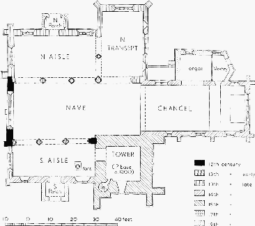
The Church of St. Edward, Stow-on-the-Wold
The church of ST. EDWARD (fn. 601) stands on the west side of the market square. It is built of rubble masonry, with ashlar for the tower and the parapets that surround all the roofs except that of the chancel, and also for some of the 19th-century work, and has Cotswold stone roofs. It comprises chancel, north vestry and organ-chamber, north transept, wide clerestoried nave, north and south aisles, north and south porches, and a tower in the position of a south transept. (fn. 602) It has been rebuilt and restored at several dates. Twelfth-century work survives in the west wall of the nave and in a reset capital of the south nave arcade. Neither the south aisle nor the nave are rectangular and neither are on the same axis as the rest of the church, and this suggests that at successive rebuildings there were attempts to reorientate the church.
The main features of the cruciform plan appear to have been established before the end of the 13th century; the south arcade was built early in the century and the north aisle and arcade by c. 1300. The chancel was rebuilt in the 14th century and the west window of the nave inserted soon afterwards; the south aisle also contains 14th-century work. The tower, a conspicuous landmark, (fn. 603) is of the 15th century but there are indications that there was an earlier tower or south transept in this position. Also in the 15th century the north transept was remodelled, the aisles re-roofed, a clerestory built above the nave, and new windows inserted in various parts of the church.
The church may have been damaged during the Civil Wars, when it was used to confine prisoners, (fn. 604) and in 1657 it was so ruinous as to be unfit for use. (fn. 605) Bishop Robert Frampton promoted its restoration in the 1680's. (fn. 606) The church was repewed piecemeal in the early 18th century, (fn. 607) and apparently from this time the south aisle and the north transept were reserved for the inhabitants of Maugersbury and Donnington respectively. A west gallery was added in 1825 at the same time as the roofs of one aisle and the transept, which had collapsed, were renewed. (fn. 608) The church was restored in 1847, (fn. 609) the nave roof rebuilt in 1859, (fn. 610) and the whole building thoroughly and severely restored in 1873, (fn. 611) when the gallery was removed. The churchyard was levelled and enclosed within a wall in 1866. (fn. 612)
The chancel, which is buttressed, has a restored or modern east window of five lights with curvilinear tracery, and early 14th-century north and south windows each of two lights with tracery. In the south wall is a blocked doorway, and the 19th-century vestry and organ-chamber have a 14th- and a 15thcentury window that may formerly have been in the north wall of the chancel. An internal string-course runs along the east wall below the window; at the east end of the south wall is a 14th-century piscina, and below the window next to it are the remains of sedilia. The trussed rafter roof seems also to be 14thcentury. The rounded chancel arch is unusually wide and springs unsupported from the walls; above it externally is a 15th-century sanctus bellcot. A rood beam was built across the arch as a memorial of the First World War.
The south arcade of the nave is of three bays, with arches of two orders springing from moulded capitals (one with nailhead ornament) on composite piers with 'water holding' bases; the eastern respond has a reset capital of the late 12th century. The north arcade has four wider bays, the eastern (and widest) arch matching those of the south arcade, the others of three orders springing from capitals with cable or nailhead ornament on clustered columns with doubleroll bases; the western respond, however, has a plain moulded capital on a plain half-round pier of greyish stone. The large 14th-century west window has five lights with curvilinear tracery surmounted externally by an ogee hood capped with a canopied niche. Below the window, on the outside, is a flat 12th-century buttress, and there are the remains of similar buttresses at the western angles of the nave. North of the window are four pieces of 12th-century ornamented coursing, each slightly different and therefore possibly reset. The 15th-century clerestory has square-headed windows which perhaps originally contained tracery. (fn. 613) The roof, raised at this period, is supported on carved corbels, but traces of the former roof line are visible above the west window of the nave.
The south aisle (the Maugersbury aisle) has a west window of four lights with four-centred heads in a rectangular opening, of the 16th or 17th century. On the south wall two early 14th-century windows of two lights with tracery flank a doorway and porch built in 1873, replacing a porch that existed in 1822. (fn. 614) West of the porch there is a scratch dial. The north aisle has a 15th-century west window of four lights with tracery, with a dripmould ending in carved heads. The late 13th-century north doorway, with its moulded arch of six orders, is flanked by two-light windows of the same date with plate tracery and external arcading. At the eastern end of the north wall is a lancet with a 15th-century cusped inner arch resting on small carved heads. The north porch is 17th-century. Both north and south aisles have ceiled roofs, and corbels (plain in the south aisle, carved as figures bearing shields in the north aisle) indicate the level of the eaves of earlier, lower roofs. The north aisle opens to the north transept (or Donnington aisle) through a 13th-century arcade of two unequal arches similar to the arcade between the north aisle and nave. The northern respond is carved with a mitred head, and the capitals have been cut to make slots for beams or screens. The main east window of the transept and the north window are both of four lights with 15th-century tracery, and the diagonal angle buttresses may be of the same period. The east window had an altar below it, presumably for one of the three chantries already mentioned, and it has been suggested that the lancets on each side of it (the southern one 13th-century, the other a 19thcentury insertion) mark the positions of the altars of the other two. Before the ceiled roof was built in 1825 the roof was supported on moulded 15th-century corbels, which survive.
The 15th-century tower is of four stages separated by string-courses, and has panelled battlements, gargoyles, and crocketted pinnacles. Heavy buttresses rise nearly to the top of the second stage, and there is an internal stair-vice, projecting slightly on the outside, in the south-west corner. There is a small south door with a small window immediately over it, a round-headed east window at the second stage, a two-light 15th-century south window with tracery at the third stage, and similar louvered openings on each face at the fourth stage. The tower opens to the south aisle through an unmoulded pointed arch, with plain imposts, probably of the early 13th century. The clock facing the market square is a successor to one put up in the early 16th century. (fn. 615)
In the chancel are mural monuments to John Chamberlayne (d. 1668) and other members of his family, and an incised floor slab to Francis Keyt, killed in the battle at Stow in 1646. (fn. 616) In the south aisle is a large 'Crucifixion' attributed to the Flemish painter Gaspar de Craeyer (1582–1669), which was given by Joseph Chamberlayne Chamberlayne in 1838 and hung for a long time behind the altar. The goblet-shaped octagonal font is late 16th-century. (fn. 617) The plate includes a chalice and paten-cover of 1682, a tankard flagon and alms plates of 1752, all gifts of members of the Chamberlayne family, and a christening bowl of 1725. (fn. 618) There were two or more bells in 1511, (fn. 619) and of the eight bells in the church in 1961 six were probably first cast in the early 17th century: two dated 1620 are apparently by Henry Farmer of Gloucester, and three bear only the dates of recasting. All six were restored in 1883, (fn. 620) and two more were added in 1897. (fn. 621) New organs were installed in 1814, (fn. 622) 1842 (apparently the barrel-organ in the gallery), (fn. 623) and 1903. (fn. 624) The registers begin in 1558; the volume for 1633–55 was missing by 1900, (fn. 625) and the entries begin again in 1680 (with a gap 1681–8) for baptisms and in 1707 for marriages and burials.
Roman Catholicism.
There is no evidence of any significant group of Roman Catholics in Stow before the 20th century. In 1918 the church of OUR LADY AND ST. KENELM was founded, and in 1961 it provided a centre from which the churches at Bourton-on-the-Water and Little Rissington were served. (fn. 626) The church, between Sheep Street and Back Walls, is a simple building of stone with a Welsh slate roof built c. 1836 as a school, (fn. 627) and adjoins an older cottage used as a presbytery.
Protestant Nonconformity.
In the 1660's dissenters held open-air meetings near Stow and three inhabitants were fined for dissent, (fn. 628) and in 1676 there were 55 nonconformists in the parish. (fn. 629) The earliest known meeting house in Stow, licensed in 1690, (fn. 630) belonged to the Friends, who had a community there by 1670. (fn. 631) In the mid-18th century there were said to be 15 Quakers, or two families. (fn. 632) Their meeting was in the 'Red Lion' yard, and although it was disused by 1850 (fn. 633) and demolished in the early 20th century (fn. 634) the graveyard adjoining it survived in 1961. There were then seven headstones of 1818–55, six of them for members of the Pegler family.
A newly built Baptist meeting house, off Sheep Street, was licensed in 1700, (fn. 635) and one of the two dissenting preachers in Stow in 1715 (fn. 636) was a Baptist. (fn. 637) In 1735 there were 44 Baptists, who then ran a school (fn. 638) and took out further licences in 1736, 1765, and 1772. (fn. 639) The minister's support was helped by a bequest of £100 in trust by Joseph Morse, by will dated 1782; (fn. 640) his initials and his wife's are inscribed on the house next to the manse in Sheep Street. (fn. 641) The father of George Payne (1781–1848), the Congregationalist divine, was Baptist minister in Stow in the late 18th cetury, (fn. 642) but earlier, and for the first quarter of the 19th century, the Baptists in Stow relied on ministers from Bourton-on-the-Water and Naunton. (fn. 643) In 1851 there was a morning congregation of 200, (fn. 644) and in 1852 a new chapel was built, (fn. 645) standing back from Sheep Street and approached through an archway beside the manse; it is of rubble, with long and short chamfered stone quoins, roundheaded windows, and a Welsh slate roof. In 1960 the chapel had a membership of c. 50. (fn. 646) In 1845 the Baptists registered for worship a newly built preaching-room in Donnington, which had a congregation of 40 in 1851 (fn. 647) and was used for services until 1883. In that year a chapel was built (fn. 648) at the south end of the village, a small simple stone building with a stone roof, which in 1961 had not been used for worship for five years. (fn. 649)
The Ebenezer chapel of the Strict and Particular Baptists, on the east side of Well Lane, may have been founded by a group that had registered a house in Stow for dissenting worship in 1798. (fn. 650) In 1830 a house in Maugersbury (but probably beside the town of Stow rather than in Maugersbury village) was registered by the Particular Baptists, and the Ebenezer chapel was built in 1840 and registered in 1842; in 1851 it had a congregation of 80 or more. (fn. 651) The chapel fell into disuse early in the 20th century, (fn. 652) and subsequently became the meeting of a group of 'closed' Plymouth Brethren. (fn. 653) The chapel, a small plain building of stone with a slate roof, has a yard containing 7 headstones of 1843–76.
John Wesley preached at Stow in 1767 to a 'very dull, quiet congregation'. (fn. 654) Early in the 19th century Methodist preachers came from Winchcombe, (fn. 655) and a house registered for dissenting worship in 1807 (fn. 656) may have been the Methodists'. In 1814 a new church was built in Sheep Street, (fn. 657) and Stow became part of the Witney circuit. (fn. 658) In 1851 the church was served from Chipping Norton and had a congregation of a hundred; (fn. 659) it was rebuilt in 1863, (fn. 660) but apparently retained its original form: rubble, with a brick elevation to Sheep Street in the Romanesque style, and with a clock tower. A manse was built in 1956, and in 1961, as part of the Chipping Norton and Stow circuit, the church had a membership of c. 20 drawn not only from Stow but also from Bourton-onthe-Water and Moreton-in-Marsh. (fn. 661) In Donnington, houses were registered for worship by Methodists in 1815 and 1819, (fn. 662) but no further record of Methodism there has been found.
Schools.
In 1381 'John scolmarster', who kept a servant, was among the poll-tax payers of Stow. (fn. 663) By the end of the 15th century the Holy Trinity guild was running a school, which became the grammar school described in an earlier volume. (fn. 664) The grammar school did not altogether cease, as has been said, in 1848: in 1847 the rector became head master and appointed an assistant master, whose salary came mostly from school pence, and in 1850 the rector asked for a grant partly to augment this salary. (fn. 665) Because of the small number of pupils the assistant master left a year or so later and started a private school; thereafter there was no grammar school, but the rector continued to receive the head master's stipend, which he later claimed to have expended on the National school. The grammar school building was used partly as a house for the master of the National school and partly as a reading room, Volunteers' armoury, and parish room. The rector's administration of the grammar school was one issue in his bitter disputes with the town. (fn. 666) In 1889 the Charity Commission ordered the grammar school building to be sold, the proceeds and former endowment to be used for scholarships for secondary education; (fn. 667) the building became the Masonic Hall.
In 1718 Sarah Thayer gave £200 in trust to support a school associated with the Baptist chapel. (fn. 668) In 1743 the school received only c. £2 a year and had a woman teacher. (fn. 669) As a day school it was very small and c. 1810 it was reorganized as a Sunday school, (fn. 670) perhaps partly because half the endowment was lost in a bad investment. (fn. 671)
By his will dated 1682 George Townsend gave £4 a year for teaching poor children, and by 1828 the whole income of £10 7s. 6d. from the land he had intended for other purposes besides teaching was paid to a schoolmistress who taught girls to read. About the same time a Sunday school was established and received the £5 a year given by William Cope (by will dated 1691) for apprenticing. (fn. 672) In 1843 the rector, churchwardens, and overseers acquired Townsend's charity estate, and probably the income from Cope's, to found a National school, (fn. 673) which in 1847 had an attendance of 58 and an annual turnover of 78. (fn. 674) The buildings in Well Lane, despite a number of building grants, subscriptions, and voluntary rates, were never adequate, but there was a certificated teacher by 1855 and attendance grew to 121 in 1878. (fn. 675) By 1886 the Department of Education was urging the establishment of a school board, and in 1887 the rector resigned as manager of the National school, the churchwardens and overseers disclaiming financial responsibility. A school board for Stow and Maugersbury was formed with the intention of using the National school building, but because of disputes over religious instruction, the National school's liabilities, and a fair price for its furniture, there was no school for nearly a year in 1887–8. (fn. 676) The school board finally took over the National school's staff of three as well as its buildings, (fn. 677) and was later given two new sites by H. Ingles Chamberlayne, lord of the manor. A new boys' school was built in the Oddington road in 1896–7, and a new girls' school in Union Street in 1901. (fn. 678) After the Act of 1944 the Oddington road school became an infants' school and Union Street the junior boys' and girls', and the older children went to schools at Bourton-on-the-Water and Northleach.
In 1836 Thomas Beale Browne of Salperton Park, with the co-operation of Francis Close (later Dean of Carlisle), founded at Stow what became known as the Beale Browne Infant School, though its children ranged in age from 5 to 14. A trust fund was raised by subscription and further endowments were received. It was a Church of England school, but by 1853 the rector regarded it as a rival to the National school and by 1884 there was hostility between Browne and the rector. Browne believed that the rector had maliciously encouraged the Department of Education and the Charity Commission to interfere with his own rather autocratic supervision of the school; the rector maintained that government pressure for a school board resulted from the inefficiency of the Beale Browne school. (fn. 679) The school was 'certified efficient' in 1904, with an attendance of 47, and in 1905 a separate infants' department was formed. (fn. 680) The school was closed c. 1908, (fn. 681) and the building, near Back Walls, later became the Roman Catholic church. (fn. 682)
The middle room of the Crescent in Maugersbury village, built in 1800, was intended as a Sunday school room, (fn. 683) but no record of its use has been found.
Charities.
The almshouses known after their 16th-century benefactor as Shepham's Almshouses presumably derived from the medieval hospital in Stow reputedly founded by Ethelmar. (fn. 684) By his will dated 1476 William Chester provided for the building or re-building of eight almshouses, in admission to which members of the Holy Trinity guild were to be given preference. The almspeople, who were to go to church daily, received 8d. a week (12d. for a man and wife living together) and were attended by a nurse. The almshouses were in use in the mid-16th century, (fn. 685) and at the end of it were reorganized and rebuilt along with the school by Richard Shepham, apparently on the site where the 19th-century buildings survived in 1961. The new arrangements, by which nine almspeople (with no nurse) were each to receive 1s. a week, were ratified by a royal charter of 1612 making the bailiffs and burgesses of Chipping Norton (Oxon.) governors of the almshouses. In addition, the almspeople benefited from the income of £200 given for their clothing by Jordan Mince by will dated 1768; from the income of £100 spent on their fuel, under the will of Edward Pitman, dated 1817; from a share in £12 a year given to the poor of Stow by William Cope by will dated 1691 (the remainder being divided among the poor not in the almshouses); and from half the income, spent on fuel, of £300 given by Mrs. Mary Hicks by will dated 1805. In the 19th century, and probably earlier, the administration of all these charities and the selection of almspeople was left to the rector and churchwardens. (fn. 686) In the mid-19th century the almshouses were rebuilt in two terraces, of six and three, the terrace of six facing south; formerly all nine had been in a single terrace facing north across the churchyard. (fn. 687)
The almshouses and almshouse charities, together with other parochial charities, were reorganized under a Scheme of 1889. Nearly all the other charities were for distributing bread: Lady Juliana Tracy gave £50 before 1702, Thomas Compere £150 in 1715, John Greyhurst £50 in 1716, Joshua Aylworth £100 in 1720, Richard Freeman £20 soon afterwards, Danvers Hodges (d. 1721) a £3 rent-charge, Sarah Chamberlayne £50 by will dated 1734, and Thomas Selwyn (or Selvin) a £1 rent-charge at an unknown date. The capital sums were all laid out in land. Townsend's gift, by will dated 1682, of 2s. a week for bread, was in fact used for education along with the sum given by him specifically for that purpose. Half of Mary Hicks's gift (see above) was for bread and beef, and the immemorial rent-charge of 13s. 4d. on the Court House was by 1828 used for bread, (fn. 688) although earlier it had been used for church repairs. (fn. 689) John Harvey Olney, by will proved 1836, gave £200 in trust for distributing coal and blankets. (fn. 690) All these charities were for the whole ancient parish of Stow; there were two separate charities for Maugersbury, £10 for distributing bread, given by Sarah Chamberlayne by will dated 1734 but apparently lost by 1828, and an allotment for the poor's fuel made at inclosure in 1766, of which the rent was distributed in cash by the rector in 1828. Apparently the poor of Stow town alone were intended to benefit by another allotment for fuel at the same inclosure. (fn. 691)
In the later 19th century all these charities were run by the rector in an autocratic manner; confusion and charges of misappropriation resulted. The charities, except for the two fuel allotments, were sorted out by the Stow-on-the-Wold Parochial Charities Scheme of 1889, which included other than purely eleemosynary charities (though educational charities were excluded from the Scheme in 1906). Under the Scheme £52 a year was to be distributed to the almspeople, who were limited to four in number, and up to £20 a year was to be expended for the general benefit of the poor. (fn. 692) In 1961 the almshouses had been condemned as dwellings, but five were occupied and stipends continued to be distributed to the almspeople. The other charities for the poor were distributed in kind, the rent from the fuel allotments being spent on coal. (fn. 693)
The Walter Reynolds Home of Rest was founded in 1929 in part of Stow that was in the ancient parish of Upper Swell by Reynolds's daughter, Mrs. Ellen Teague, to provide rent-free accommodation for six aged inhabitants of Stow with limited means. (fn. 694)