A History of the County of Gloucester: Volume 9, Bradley Hundred. The Northleach Area of the Cotswolds. Originally published by Victoria County History, London, 2001.
This free content was digitised by double rekeying. All rights reserved.
Carol Davidson Cragoe, A R J Jurica, Elizabeth Williamson, 'Parishes: Northleach with Eastington', in A History of the County of Gloucester: Volume 9, Bradley Hundred. The Northleach Area of the Cotswolds, ed. N M Herbert (London, 2001), British History Online https://www.british-history.ac.uk/vch/glos/vol9/pp106-145 [accessed 30 April 2025].
Carol Davidson Cragoe, A R J Jurica, Elizabeth Williamson, 'Parishes: Northleach with Eastington', in A History of the County of Gloucester: Volume 9, Bradley Hundred. The Northleach Area of the Cotswolds. Edited by N M Herbert (London, 2001), British History Online, accessed April 30, 2025, https://www.british-history.ac.uk/vch/glos/vol9/pp106-145.
Carol Davidson Cragoe, A R J Jurica, Elizabeth Williamson. "Parishes: Northleach with Eastington". A History of the County of Gloucester: Volume 9, Bradley Hundred. The Northleach Area of the Cotswolds. Ed. N M Herbert (London, 2001), British History Online. Web. 30 April 2025. https://www.british-history.ac.uk/vch/glos/vol9/pp106-145.
In this section
NORTHLEACH WITH EASTINGTON
The parish, comprising the small town of Northleach and a rural area called Eastington, lies in the central Cotswolds 18 km. ESE. of Cheltenham and 16 km. NE. of Cirencester. A manor based there by the late 8th century was called Leach (fn. 1) from the small river that rises close by in Hampnett parish, but from 1100 or earlier the place was called Northleach to distinguish it from other Gloucestershire settlements further downstream that took their names from the river. (fn. 2) Settlement at Northleach comprised a series of small hamlets lying along the river valley, at the highest of which the owner of the manor, Gloucester abbey, founded a borough and market town c. 1220. In the late Middle Ages, when the town served as a distribution centre for the Cotswold wool trade, it enjoyed prosperity and a significance out of proportion to its size. That trade also stimulated a small clothmaking industry, and the town developed a fairly sophisticated system of borough government. After the loss of its trade and manufacture in the early modern period Northleach had only a minor place among Gloucestershire towns, though its importance was enhanced by coaching in the early 19th century and by a role in local administration.
The ancient parish was bounded on the west by the Roman Foss way, which was recorded there as the 'Fos' c. 1220. (fn. 3) From the Foss the north-east boundary follows field boundaries and, west of Farmington village, the ramparts of a hill fort called Norbury, before joining the river Leach below Eastington; the river forms the east boundary. The south boundary follows field boundaries from the Leach westwards to the site of a long barrow called Crickley barrow on part of a medieval salt way which led from the Thames at Lechlade to Droitwich (Worcs.). The salt way, recorded by that name in 1652 (fn. 4) and giving to an isolated farm building the name Saltway barn, provides the parish boundary as far as the Foss way, at a crossroads that was probably the meeting place of Bradley hundred. (fn. 5)
By the establishment of Northleach borough 43 a. (17.5 ha.) was separated from the ancient parish for administrative purposes, leaving 3,955 a. (1,601 ha.) as a rural manor (fn. 6) called Northleach Foreign or Eastington. (fn. 7) Eastington (the name more commonly used by the modern period) became a separate civil parish in the mid 19th century, (fn. 8) but it was joined with the town again in 1950 to form the parish of Northleach with Eastington; a small part of Hampnett on the west side of the Foss way, including a former prison, was then added to the new parish. (fn. 9) Until the early 19th century a hamlet in Coberley called Upper (or Little) Coberley or Pinswell, which had been an outlying member of Northleach manor in the 11th century, remained attached to Northleach Foreign for some administrative purposes. (fn. 10)
The low and narrow valley of the river Leach is the central feature of the landscape. The river is joined at Northleach town by a tributary spring, rising on the hillside to the south at a place called the Wellings (fn. 11) or Seven Springs, and other springs rise further down the Leach valley. The north end of the parish includes part of the valley of a feeder spring of the Sherborne brook. Otherwise the parish is formed of level, mainly treeless Cotswold upland at around 170–190 m. The bulk of the land is formed of the Great Oolite, with the Inferior Oolite and fuller's earth appearing in the Leach valley. (fn. 12) Much of the land was once farmed as open fields and there was common downland near the north and south boundaries. At parliamentary inclosure in 1783 (fn. 13) the south part of the parish was formed into large fields bounded by drystone walls, for which the Act laid down a height of 4 ft. 8 ins. at roadsides. (fn. 14) In the mid and later 19th century some small coppices and fox-coverts were planted among the fields.
Shortly before 1627 land in the Leach valley at the east boundary was taken into New park (later called Lodge park), a deer park and deercoursing paddock created by John Dutton, owner of the Sherborne estate and of Eastington manor. (fn. 15) Between 1726 and 1728 his descendant Sir John Dutton inclosed open-field and downland to take in more land, (fn. 16) which extended the park to the Eastington-Aldsworth road. About 1820 Lodge park, which also included land in Sherborne (where the 17th-century lodge house stands), Aldsworth, and Farmington, had 151 a. in Eastington; that land was then partly farmed as arable fields, interspersed by a geometrical pattern of plantations, (fn. 17) mainly of beech.
In the north part of the parish, adjoining Farmington, there is an extensive rectangular hill fort, covering 80 a. (fn. 18) The fort may have been called Hertbury in the early 13th century, when Hertbury gate was mentioned, (fn. 19) probably situated where the road from Farmington village to the Foss way broke through the fort's west bank, but in 1621 and later it was called Norbury. (fn. 20) Much of the bank is still visible on the east and west sides, other parts having been destroyed by ploughing before 1770. (fn. 21) In the part of the parish south of the town, near Winterwell Farm, traces of extensive ditches and enclosures have been observed, (fn. 22) and there was perhaps another ancient earthwork further north at Helen's ditch, which was recorded in 1642 and 1706 as Ellins ditch. (fn. 23)
In 1327 23 people were assessed for tax in Northleach borough and 26 in Northleach Foreign (Eastington). (fn. 24) For the poll tax of 1381 only a fragment survives of the original assessment made for the borough, but it presumably contained some 200–300 people, seeing that a later, reassessment roll found an additional 41 lesser payers (classed as labourers or servants). (fn. 25) For the foreign the first assessment, also fragmentary, has 24 or more people, while 5 lesser payers were included in the reassessment roll. (fn. 26) In 1551 c. 400 communicants were recorded in the whole parish, (fn. 27) and in 1563 119 households were recorded in the town and 12 households in Eastington. (fn. 28) The whole parish was said to have 440 communicants in 1603, (fn. 29) 120 families in 1650, (fn. 30) and c. 900 inhabitants in 200 houses c. 1710. (fn. 31) About 1770 the figures produced by what was said to be a careful local census were 683 inhabitants comprising 149 families, (fn. 32) and in 1801 814 people were enumerated, 664 in Northleach town and 150 in Eastington. The town's population rose to 795 by 1831 and to 962 by 1861 but later declined to 787 by 1891 and 596 by 1931. Eastington's population rose to 442 by 1861, fell away to 307 by 1901, but then stabilized and was 334 in 1931. In 1951 the town and Eastington, united once more as a single parish, had a population of 932. There was then little change until the 1980s: in 1981 the population of the parish was 1,043 but new building in the town, following the opening of a bypass in 1984, raised it to 1,462 by 1991. (fn. 33)
From the mid 18th century the road running through Northleach town from west to east was one of the principal thoroughfares of the county as the route from Gloucester and Cheltenham to Oxford and London. Earlier, however, it was of less significance than the Foss way from Cirencester to Stow-on-the-Wold, passing west of the town; it was the Foss that was used to define the town's position in an account of c. 1710. (fn. 34) The road passing through Northleach town was called Burford way east of the town in 1640 and 1705 (fn. 35) from the next market town in that direction, and west of the town it was described in 1376 as the way to Hampnett (fn. 36) and in 1576 as the way to Cheltenham. (fn. 37) Gloucester during the Middle Ages was probably reached from Northleach by a route through Chedworth and Elkstone, (fn. 38) leaving the town at Millend. Before the coaching era much traffic travelling from the Gloucester and Cheltenham direction towards Burford and Oxford evidently bypassed the town by a road following the high ground to the north, recorded as the ridgeway in 1600, (fn. 39) as the Gloucester to Burford road in 1707, (fn. 40) and as the old London road in 1783. (fn. 41) It branched from the later main road on Puesdown in Hazleton parish and rejoined it c. 6 km. further east at the boundary of Northleach and Farmington parishes. (fn. 42)
The road through the town was turnpiked in 1751 (fn. 43) and by the 1770s was established as the principal coaching route from Gloucester and South Wales to London. (fn. 44) The turnpike trust initially took responsibility also for the old London road: in 1777 there was a turnpike on it north of Hampnett village, as well as one on the main road at Hampnett downs, (fn. 45) and in 1826 it was described as a disused turnpike road. (fn. 46) Although the old London road was apparently never given a stone surface, some coaches and wagons presumably continued to go that way in the late 18th and early 19th centuries, perhaps using the New Barn inn, in Farmington parish, (fn. 47) as a staging-post rather than Northleach town. In the 1820s there was a turnpike gate at its junction with the main road east of the town. (fn. 48) In 1997 most of the old London road survived as a broad green lane, but a stretch in Hampnett, just west of the Northleach with Eastington parish boundary, had by then vanished under ploughland. The Foss way along the west boundary of the parish was a turnpike road from 1755 to 1877. (fn. 49)
By 1757 a London to Gloucester stagecoach ran through the town, making three trips a week, (fn. 50) and from 1785 Northleach was on the mailcoach route from London to Gloucester and South Wales. (fn. 51) The King's Head at Northleach became the principal coaching inn and posting house, with from c. 1820 the Sherborne Arms as a less successful rival. (fn. 52) A number of smaller inns also served road transport, and in the 1820s stables were maintained in the town by Heath & Co. and John Spencer, two of the principal Gloucester operators of coaches and carriers' wagons. (fn. 53) In 1830, when traffic on the road contributed largely to the town's 'appearance of liveliness and business', the mail and five other coaches operated outward and return services between London and Gloucester and Cheltenham each weekday, and a seventh ran beyond Cheltenham to Worcester. (fn. 54) Coach traffic through Northleach was reduced from 1841 by the opening of a station at Cirencester on a branch from the Great Western railway, (fn. 55) though the following year, and presumably until the completion of the railway link between Swindon and Gloucester in 1845, the mail and two other London coaches still passed through the town, connecting with the railway at Steventon (Berks., later Oxon.). (fn. 56) In 1853 only a single coach ran through between Oxford and Cheltenham. (fn. 57) The failure of various schemes for a direct rail link between those two places (fn. 58) helped to give the road, which was disturnpiked in 1870, (fn. 59) a continuing local importance in the later 19th century.
With the growth of motor traffic in the 20th century the road through Northleach became once more, as the A40 trunk road, one of the main arteries of communication between South Wales and London. As early as 1903 the Northleach rural district council was lobbying the government and county council for the regulation of motor cars, (fn. 60) by 1929 the speed of traffic through the town and the obstruction of the main street by parking concerned the parish council, (fn. 61) and by the early 1930s the crossroads on the Foss way by the old prison were the scene of many road accidents. (fn. 62) In 1933 motor traffic was said to have some extent 'resuscitated' Northleach, (fn. 63) but later in the century it came to be seen as a hindrance to its economy, deterring residential development. Although much of the long-distance freight traffic ceased to pass through Northleach with the completion of the M4 motorway in the early 1970s, (fn. 64) the building of a bypass, which had been under discussion from the 1930s, was eagerly anticipated. (fn. 65) It was opened north of the town in 1984, (fn. 66) its course running for the most part just south of the old ridgeway road.
The site where Northleach town was laid out c. 1220 was the highest (and evidently the primary) hamlet of a series of small settlements along the river Leach in Anglo-Saxon and early medieval times. The existence of the hamlet, a reasonable supposition from the location there of the parish church (recorded from 1100 (fn. 67) with no evidence that it had a different site) and of the manor farm, adjoining the church, is confirmed by a mention of 'those who lived in the hamlet where the borough now is' in Gloucester abbey's grant of liberties to the new burgesses. (fn. 68) The hamlet was established near the crossing of the Leach by a road from Farmington towards the Foss way and Cirencester and it probably lay mainly on the south side of the valley, around the church. The yards and buildings of the manor farm extended around the north, east, and south sides of the church and churchyard, including on the south the manor mill on the stream descending from the Wellings to the Leach, (fn. 69) and the vicarage house occupied the west side. All those buildings, which served the ancient parish as a whole, were excluded from the later bounds of the borough. Some houses of the original hamlet may have been in the area immediately to the south called Millend; Millend was included within the borough bounds but retained a less ordered plan than the remainder of the borough. (fn. 70)
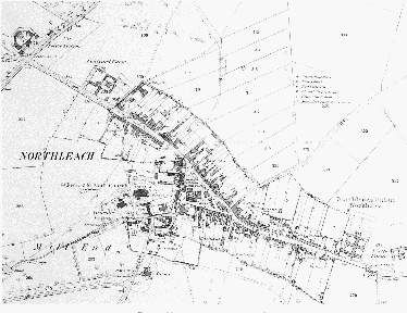
Fig. 7. Northleach town in 1883
The establishment of the borough by Gloucester abbey evidently coincided with the grant of the right to hold a market which the abbey secured in 1219 or 1220, (fn. 71) and Northleach was described as a 'new market (town)' c. 1235. (fn. 72) The abbey offered the builders of dwellings on the new burgages the incentive of three years' freedom from rent and services, (fn. 73) and it was successful in attracting people from the neighbouring Cotswold villages. The surnames of burgesses recorded in 1267 recalled origins in the Rissingtons, Hazleton, Windrush, Yanworth, Turkdean, Cowley, and Aylworth (fn. 74) and, in 1291, in Dowdeswell and the Shiptons. (fn. 75)
The town was laid out on a simple plan based on a main street running along the valley and a triangular market place on the south-west side of the street immediately below the church and manor farm. (fn. 76) The part of the street south-east of the market place, which in the 15th century and later was known simply as East End, (fn. 77) was possibly based on an existing lane coming from the Burford direction. The north-west part of the street, known by the late 14th century as Foss End (fn. 78) but also called West End, (fn. 79) was per- haps a new street replacing a track higher up the valley side, for originally it did not form a crossroads at the Foss way; the road towards Cheltenham left the Foss c. 200 m. further south-west until c. 1825 when a new stretch of road was built connecting with the town street by the old prison. (fn. 80) The bulk of the old urban area comprises long burgage plots, in an unbroken succession along the north-east side but in a less orderly pattern on the south-west side due to the interruption of the church and manor and to infilling within the market place. The bounds of the borough, first found described in 1605, (fn. 81) related purely to the urban area: they were drawn closely around the outer ends of the burgage plots, and on the north-west they did not even extend, as would have seemed logical, as far as the Foss way. (fn. 82) No agricultural land was included, though common rights in two pastures elsewhere in the parish, enjoyed by the inhabitants of the old hamlet, were assigned to the burgesses by Gloucester abbey. (fn. 83)
A total of 65 burgages had been established by 1267, including two half-burgages and a number of others in joint tenancies; another seven tenements, though held on the same terms as the burgages in 1267, were described as 'messuages' and possibly represented agricultural holdings of the original hamlet. Several burgesses held land called 'forlonde' for small cash rents, probably encroachments made on the street in front of their houses. (fn. 84) An increase in the population of the borough in the later Middle Ages, stimulated by its wool trade, resulted in the division of the original burgage plots and in infilling and new building around the market place. The plots were divided longitudinally to preserve access for all owners to the main street, producing a pattern made up of various widths. Half-burgages were common by the early 15th century when seven figured in the changes of ownership recorded at two borough courts held in 1412 and 1413. (fn. 85) In 1551 there were 23 full burgages, 32 half-burgages, and 4 quarter-burgages. Also by then there had been a number of amalgamations to create houses with larger street frontages: 8 holdings each comprised one and a half burgages and another comprised three burgages. (fn. 86) The tenants of the plots described in 1551, who were those responsible for paying the chief rents to the lord of borough, no doubt often had subtenants in parts of their holdings: in 1539 a burgage at Foss End and a half-burgage at Millend each contained four cottages. (fn. 87)
The triangular market place came to be partly obscured by houses and other buildings, some of them presumably on the sites of earlier freestanding shops, of which four where recorded in the middle of the market place in 1267. (fn. 88) During the 1370s and 1380s Gloucester abbey granted plots there to at least four men for building shops, and in 1391 the Crown, which had laid claim to the right of soil in the borough, disputed the abbey's ownership of those shops and of two leasehold houses in the same area. The basis for the Crown's claim is obscure and it was apparently abandoned after an inquiry in 1395. (fn. 89) Building in the south part of the market place, forming two blocks of houses with some isolated houses, divided off an area which became known by the early 18th century as the Green. (fn. 90) Most of those houses were later freehold and classed as burgages (fn. 91) and so may represent development of a period before the late 14th century, by which time the abbey seems to have favoured the creation of less permanent tenures. Houses in a row on the west side of the market place, north of the entrance to the churchyard, were copyhold or leasehold in the 16th century (fn. 92) and remained leasehold under the lord of the borough in the early 18th, and so are likely to represent late-medieval development.
The only side roads joining the main street were the Farmington road, which was known as Conduit Street in the early 17th century, (fn. 93) the Cirencester road running down through Millend to the west corner of the market place, and the Eastington road at the south-east end of the town. A few minor alleys ran between the burgage plots, including Antelope Lane, leading to the church from the former inn of that name at West End, and one on the north-east side called College Lane in 1663, Collins Lane in 1736, Colliers Lane in 1958, (fn. 94) and Doctors Lane in 1997. The little river Leach flowed down the main street in West End and across the market place to join the Wellings stream and form the back boundary of the burgage plots on the south-west side of East End. Several small bridges were maintained out of the common town funds (fn. 95) until the late 19th century when the stream in the main street and market place was culverted. (fn. 96)
The market place, as it survived after the medieval infilling, remained the focus of town life. In the middle of it stood the town's high cross, recorded in 1559 when a royal commission was read there. (fn. 97) The cross was kept in repair out of the town funds until 1747 (fn. 98) or later, but only its stepped base survived c. 1800. (fn. 99) One part of the range of leasehold houses on the west side of the market place was described as the old boothall in 1594 (fn. 100) and was presumably the town's market house in the late Middle Ages, being replaced shortly before 1551 by a new free-standing boothall or market house built within the market place. (fn. 101) The new building, which was of the usual type with an open ground floor and a room above where the burgesses' town court met, (fn. 102) was demolished c. 1820. (fn. 103) In the 1730s two small free-standing shops, leased with two of the tenements in the range on the west side, stood to the north of the market house. (fn. 104) A house at the south-west corner of the market place known as the Wool House in 1805 (fn. 105) may have played some part in market trade.
About 1530 William King gave a burgage in the central part of the town to the townspeople, intending that the upper storey should be used as a church house, for parishioners' meetings, and the lower part for a market house; the abbot of Gloucester supported the gift by pardoning part of the chief rent and reliefs he was owed. That building was in use as a church house as well as for a tavern in 1629 (fn. 106) but it may never have been employed for market purposes. By the early 18th century the building, then called the town house or church house, was leased as a private house. (fn. 107)
The town, which enjoyed its main period of prosperity at an early date and occupied a constricted valley site unsuitable for laying out large gardens, has no very large private houses. The houses almost all front the main street and market place, where the more important were at one time inns and in some cases originated as the premises of wool merchants. Building is almost entirely in stone, before 1800 mainly in coursed rubble and after that date mainly in dressed freestone or with ashlar facing. Several houses built before 1600, however, have exposed timber-framed upper storeys, and in others timber framing is concealed behind stone facades. A house in East End (Old Timbers) has a gabled and jettied chamber wing and a former hall of one bay. Other buildings, concentrated on or near the market place, have continuously jettied upper floors, and a few, including the Red Lion inn, seem not to have been heated and were possibly not built for domestic purposes. Few of the houses with surviving gabled 17thcentury fronts are of great size or sophistication; two of better quality stand near the junction with the Farmington road and another (Manor Cottage) is on the south-west side of East End. Some of the early fronts were raised in the 19th century from two and a half gabled storeys to three storeys with a straight parapet.
About 1770 the town was described as being in a state of decay with many houses having fallen down; (fn. 108) if that was the case they were replaced during the temporary revival of the town during the coaching era at the end of the 18th century and in the early 19th. In 1820 almost the only gaps in the street frontages were in the south part of Millend and on two large plots at the far end of West End, one of which (called simply the Burgage) (fn. 109) was already empty by 1682. (fn. 110) During the coaching era many houses were rebuilt or refronted, usually in ashlar, and in the late 19th century and the early 20th some houses, including several built originally as small cottages, were made to appear more traditionally Cotswold in character by the addition of gables.
A house that played a central role in the town's history was that called the Great House, standing on the north-east side of the main street by the junction with the Farmington road. Called in 1575 Bush's great house, (fn. 111) it had evidently belonged in the early 16th century to a wealthy wool merchant, Thomas Bush. Thomas Dutton (d. 1581) of Sherborne and his son William gave the house in aid of the town's clothmaking industry and from 1618 it was part of assets held by the town's bailiff and leading burgesses in trust for charitable and other purposes. (fn. 112) By 1768 it housed an inn, which was called the Lamb (fn. 113) until 1818 when it was leased to John Dutton (later Lord Sherborne); he remodelled the building to form a coaching inn under the sign of the Sherborne Arms. (fn. 114) It failed to compete successfully with the town's other large inn, the King's Head, and part was converted as a private house in 1840; (fn. 115) part remained an inn until the mid 1850s, (fn. 116) the sign being transferred later to a public house on the market place.
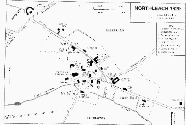
Fig. 8.
Behind its street front the Great House had considerable outbuildings, forming a galleried courtyard. About 1770 those buildings were thought to have been used for the sale and storeage of wool, (fn. 117) and perhaps in Thomas Bush's time they were used under his auspices as a public dealing place for that commodity. In the early 20th century a long range surviving on the Farmington road to the north-west was thought to be late medieval, (fn. 118) and the fairly extensive rebuilding work carried out on the house by the town trustees in 1636 (fn. 119) was perhaps to the main street range. During Lord Sherborne's improvements c. 1820 the front range was rebuilt as two storeys and 8 bays, (fn. 120) apparently to a design of G. A. Underwood of Cheltenham. (fn. 121) The Great House was demolished except for the southeastern two bays of the street range and part of a back range, once forming the south-east side of the courtyard, when the Farmington road was widened in 1936. (fn. 122)
Walton House, on the north-east side of the street, to the north of the market place, was evidently the property comprising three burgages owned by Thomas Midwinter in 1551 (fn. 123) and the 'great messuage', formerly the Swan inn, owned by Edmund Midwinter at his death c. 1594. (fn. 124) Thomas was possibly a descendant of a leading Northleach woolman William Midwinter (d. 1501) (fn. 125) and so that house too may have played a role in the wool trade. By 1693 it had become the King's Head inn and was owned and kept until the mid 18th century by a prosperous Northleach family called Stone. (fn. 126) By the 1790s it had established itself as the leading coaching and posting inn, (fn. 127) a position it maintained in the early 19th century when kept by members of the Heath and Day families; (fn. 128) 18 inn servants lived on the premises in 1841. (fn. 129) With the decline of coaching, the Days concentrated on the breeding and training of racehorses, and racing stables at the premises were continued by later owners after the Days left c. 1857. The inn closed soon after 1859, (fn. 130) its sign being taken later by a small public house south of the Green. (fn. 131) Walton House was converted to flats by the Northleach rural district council in 1959, (fn. 132) and c. 1987 a private company acquired it for sheltered housing, modernizing the flats and building twelve small dwellings in the grounds. (fn. 133)
An open yard on the north-west side of Walton House, presumably achieved by demolishing one of the constituent burgage houses, provided the inn with a circular carriage drive, from which there was formerly an entrance through the north-west range to the enclosed courtyard behind. (fn. 134) The outward-facing facades, towards the yard on the north-west and towards the street on the south-west, were rebuilt in the late 18th century, (fn. 135) the former including a first-floor Venetian window. Irregular fenestration on the facades, however, betrays that an L-plan block has been extended by a north-west range. The earliest work visible internally is at the south-east end of the street range, where a mid 16th-century room has moulded ceiling beams and the blocked remains of an elaborate stone window of at least two hollow-moulded arched lights, with carved spandrels and a broad moulded surround. Under the north-west end of the same range is a cellar with transverse ribs and a double-chamfered entrance arch. The room above it has a fourcentred arched chimneypiece and intersecting beams. The house immediately adjoining Walton House on the south-east (called Cotswold House in 1997) was leased with and used as part of the inn from 1736 and throughout the coaching era, (fn. 136) and its street front was rebuilt in conformity with the inn in the late 18th century. A large stable block behind Walton House was converted to dwellings in the late 20th century.
A large building on the south-west side of West End, described as 2½ burgages in 1684, (fn. 137) formed the Antelope inn by 1580. (fn. 138) It closed for a period in the mid 18th century, being described as formerly an inn in 1754, but it was later reopened under the same sign, presumably by one of two successive landlords of the King's Head, John Miles and James Heath, who became its owners in 1783 and 1804 respectively. (fn. 139) The Antelope closed again before 1830. (fn. 140) Rather like Walton House, it had two long ranges at right angles to each other. The roof shows that the two ranges formed a substantial two-storeyed house of c. 1500. The street range contained a hall of two bays. Its roof has an arch-braced tiebeam truss with raking struts, two tiers of trenched purlins, and a tier of windbraces, (fn. 141) and there is a smoke bay at the north-west end of the hall. The roof continues south-eastwards over a chambered end of two bays and, minus raking struts, southwestwards for four bays over the rear wing that extends from it. The north-west two bays of the street range (not inspected) were rebuilt in the early 19th century when, following its closure as an inn, the Antelope was remodelled as a terrace of three houses of different sizes behind a facade with sash windows and doorways with fanlights. During those alterations the centre house (called Antelope House in 1997) acquired a two-storeyed addition across the back of the house, containing a staircase, and a central rear wing.
At the north-west corner of the market place a house called Cotteswold House in 1997 retains part at least of a house that was occupied in the late 16th century by Thomas Parker, then lessee of the manor farm and the town's leading inhabitant. (fn. 142) In 1582 the borough court allowed him to inclose the triangular plot of ground that forms the front garden of Cotteswold House, then bounded on the north-east by the stream flowing along the main street. (fn. 143) The surviving fabric seems to be of the 16th century and indicates a house of two or two and a half storeys with a through-passage plan. A plank and muntin screen divides a north parlour, with a hollow-moulded beam and the remains of a stone winder stair, from a larger south room, later subdivided, which has in the west wall a double-chamfered external doorway with a depressed arch, and a large chimney stack. On the first floor the stack has a stone chimneypiece with a moulded depressed arch and the initial 'P', evidently for the Parker family, carved on one spandrel. (fn. 144) In the 19th century the street front of the house was rebuilt in ashlar and taken up to a straight parapet. In the 17th century the north-west wing was built as a service addition and was extended later by an outbuilding with a hayloft. A considerable length of the street front to the north-east of Cotteswold House was within its grounds until filled by a row of cottages in the early 20th century: (fn. 145) that appears to reflect the former status of the house and suggests the possibility that the surviving building was part of larger premises.
A tenement and barn leased by Gloucester abbey in 1538 and described as within the town but adjoining the site of the manor (fn. 146) had passed by 1575 to a prominent Northleach mercer called Henry Winchcombe, who took a new lease from the Crown. (fn. 147) They can probably be identified with the house adjoining Cotteswold House on the south, which Winchcombe certainly held in 1596 when he was allowed to inclose from the market place the plot of land in front of it; (fn. 148) by the 1730s, when it was described as a large ancient messuage, it had been partitioned as three separate tenements. (fn. 149) It was remodelled as a single house c. 1927 and named Doctors Commons (fn. 150) but it formed three dwellings again by 1997. Behind the later facade are the remains of a mid 16th-century house. The north two bays of the five-bayed front range appear to have been a parlour. A rear wing runs west from the parlour end and is entered through a doorway with a four-centred arch. At least two of the windows at its east end are of the 16th century, one having three arched lights, the other a single light. The rear wing was extended in the 19th century, and it has several replica 16th-century windows, presumably inserted as part of the alterations in the 1920s. During those alterations the street front of the building was refaced and given gables. (fn. 151)
A house on the south side of the Green called in 1997 Tudor House was apparently (fn. 152) the inn called 'le Pyke' which was owned by Llanthony priory, Gloucester, at its dissolution in 1539 (fn. 153) and, having thus passed into royal ownership, was renamed the Crown inn before 1555. (fn. 154) It remained open as an inn until 1613 or later. (fn. 155) Tudor House, which retains the plan of an early inn and has a jettied, timber-framed upper floor, was in several occupations in 1997, including shops on the ground floor. The three east bays, which include the gate passage, date from the earlier 16th century. (fn. 156) Stone corbels supporting the brackets that flank the passage have carved crosses. (fn. 157) The timber-framed upper floor has down bracing and the roof has insubstantial principal rafters, purlins, and windbraces. Over the west end of the central passage a timberframed gable is exposed within a later stone extension. The three west bays were added in the 17th century, and in the 18th or 19th centuries stone-built additions at the rear enlarged the building to a U plan.
College House, on the west side of Tudor House, is one of the few houses that faces onto its own grounds rather than the open street. The large site originally comprised two burgage plots, (fn. 158) which by the early 19th century were in a number of separate occupations. The western one included a house which was described in 1705 as 'Lymerick's (or Limbrick's) great house', possibly a reference to a mid 16thcentury townsman, Thomas Limbrick. It was owned at different periods by two of the headmasters of Northleach grammar school, the Revd. George Iles (d. 1730 or 1731) and (in right of his wife Mary Harrits Allen) the Revd. John Allen (d. 1809), (fn. 159) and by purchases made in 1821, 1823, and 1855 the patron of the school, Queen's College, Oxford, acquired the whole site under a scheme to provide a permanent residence for the headmasters. (fn. 160) Probably in the 1840s, during the headmastership of the Revd. Joseph Askew, (fn. 161) the house once Allen's was rebuilt or extensively remodelled, being given a symmetrical south front in a late 17th-century style, with a hipped roof with dormers and with mullioned and transomed windows. After 1856, in order to accommodate a 'commercial' and boarding school, nominally part of the grammar school, the building was much extended to the north by the addition of two rear wings. The additions were probably made in several stages, but some had been done by 1861 when the school had over 40 boarders. (fn. 162) College House remained in use as a headmaster's and boarding house after the grammar school was reformed in 1877. (fn. 163) It was sold by the school governors c. 1980 and converted to four separate dwellings. A building on the Green to the north-east of the house, partly of the 17th century, was adapted as the coach house and stables in the mid 19th century and converted as two dwellings in the 1980s. (fn. 164)
At the north-west end of the town, just beyond the borough boundary, a farmstead called Coalyard Farm was established by Lord Sherborne after he inclosed Eastington in 1783. The three-storeyed, symmetrically-fronted stone farmhouse was built soon after the inclosure but was remodelled in the early 19th century, probably c. 1830, when it was given a lowpitched, hipped roof and the windows and internal fittings were altered. (fn. 165) The extensive buildings and yards included a coalyard by 1820, (fn. 166) presumably a depot used by wagons bringing coal supplies for the town from Cheltenham or elsewhere in the Severn Vale. The farmer, James Walker, continued to deal as a coal merchant in the 1850s and 1860s. (fn. 167) At the other end of the town, opposite the entrance to the Eastington road, a small farmstead called Nostle Farm, the name taken from a nearby spring, Nosewell, (fn. 168) was established in the mid 19th century at the site of an older barn. (fn. 169)
The earliest modern additions to the town were in the form of council housing. Northleach rural district built four houses at the entrance to the Eastington road in 1932 and 1933 (fn. 170) and 10 houses at a site called the Tannery (later Farmington Rise) on the south-east side of the Farmington road between 1938 and 1940. (fn. 171) Between 1951 and 1954 it built another small estate on the opposite side of the Farmington road. That began the Walton estate, (fn. 172) which eventually covered the hillside behind the old burgage plots north-east of the market place and West End. The council built 46 houses on the Walton estate during 1956 and 1957, (fn. 173) and in the late 1950s and early 1960s flats and bungalows for old people were added there, while Walton House was converted to flats and bungalows were built on part of its grounds. (fn. 174) The council's last major housing project was a block of old people's flats called Fortey House opened at the Walton estate in 1967. (fn. 175) Private development was deterred by the town's traffic problem and discouraged by the planning authorities until the opening of the bypass in 1984. (fn. 176) After 1984 a substantial private estate was built on the hillside above and adjoining the Walton estate and a smaller development on the opposite hillside. Other new houses were built at the southeast end of the town, including at the site of Nostle Farm, and in 1997 another estate was under construction at the same end of the town at the site of the former Westwoods school beyond the Eastington road.
In Eastington, the rural area of the ancient parish, settlement was presumably confined in the Middle Ages, as it was in early modern times, to small hamlets in the Leach valley. Eastington manor comprised over 40 tenant holdings in 1267, (fn. 177) and so settlement in the valley was probably then almost linear in character. The usual amalgamations in holdings occurred in the late Middle Ages, reducing the total to 19 by 1541, (fn. 178) which presumably changed the pattern and emphasised the separate identity of the small hamlets in the valley.
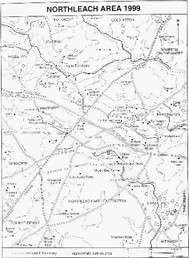
Fig. 9.
The highest of Eastington's hamlets, called Cockthrop, stood in the Leach valley just downstream of the end of Northleach town and the Eastington road. The hamlet was recorded from 1292 (fn. 179) and still had five or more small farmhouses in the 1580s. (fn. 180) It was deserted by the late 18th century, when a piece of land called Cockthrop green straddled the Leach at a point where in 1997 the remains of a ford, with a track leading to it down the south side of the valley, were visible. (fn. 181) The earthwork foundations of several small dwellings were then evident on the hillside, extending between the track and the Eastington road, and below, closer to the river, were the foundations of a larger structure, possibly a farm building. (fn. 182) Further downstream, grouped around a track that descends the southwestern side of the valley to another ford over the river, is a hamlet called in modern times Upper End. It was apparently that called Upthrop in 1267 (fn. 183) and Great (or Mitchel) Upthrop later in the Middle Ages. (fn. 184) In 1997 Upper End comprised four dwellings with attendant farm buildings; they included Upper End Farm and Eastington Manor which are described below with the freehold estates to which they became attached. (fn. 185) Middle End, a short way down the valley on the same hillside, may be the site of another medieval hamlet, perhaps the 'Little Upthrop' whose existence is implied. After the inclosure of Eastington in 1783, however, Middle End comprised a single farmhouse, the centre of one of the Sherborne estate's large farms in the parish. (fn. 186) It was rebuilt or remodelled in the mid 19th century as a tall, three-storeyed building with 17th-century style windows, and its roof was renewed with the addition of dormers c. 1963. (fn. 187) A pair of farm cottages was built at the entrance to its drive on the Northleach–Aldsworth road in 1905. (fn. 188)
The lowest hamlet, called Lower End by 1696, (fn. 189) is situated where the Leach is crossed by a lane leading south-westwards from the main Oxford–Cheltenham road towards Cirencester. It was probably to that hamlet that the name Eastington specifically related before being adopted as the name of the whole rural area (or 'foreign') of Northleach parish. Surviving earthworks at Lower End suggest an early-medieval hamlet of considerable size, based on a track leading from the upper hamlets along the southwestern side of the Leach valley. North-west of the existing hamlet part of that track is flanked by the foundations of c. 8 small houses, which are probably the remnants of some of the medieval copyhold farmhouses, and similar earthworks are visible in two closes further southeast, beyond the hamlet. (fn. 190) A chapel of ease, built for Eastington before the end of the 14th century, stood beside the same track near its junction with the lane to Cirencester on a site later occupied by a 19th-century mission chapel. (fn. 191) The only surviving farmhouse, Lower End Farm, stands near by on the other side of the lane. Its core is a modest-sized, 17th-century house with mullioned windows and a central stack and there are 19th-century additions, including stables which had been converted to cottages by 1997. Otherwise Lower End is formed mainly of small cottages built by James Dutton, Lord Sherborne, to house farm labourers after he reorganized his Eastington estate at the inclosure of 1783. They are plain in character and are sited fairly haphazardly on the hillside and in the valley bottom, there being evidently no intention to create a 'model' village. There were said to be c. 20 new cottages in all, (fn. 192) but several buildings once comprising pairs or longer terraces had been converted to single dwellings by 1997.
After the inclosure in 1783 a few farmsteads were established on the high, open land in the south of the parish. Broadfield Farm, near the south-east corner, was built for the Sherborne estate and probably completed as early as 1785. (fn. 193) In 1850 it comprised a long plain, two-storeyed range, apparently in two builds. (fn. 194) About 1860 the eastern part was replaced by a gabled Lshaped wing and the two parts apparently formed into separate dwellings, perhaps to provide accommodation for a farm bailiff as well as the tenant. Late 18th-century barns and cattlesheds surround a yard to the west of the house. A row of four labourers' cottages was built for Broadfield farm on the farm track to the east in the mid 19th century, and another cottage was built at Trowell Head to the north-east. (fn. 195) At Cottage Farm, called from the early 20th century Crickley Barrow Farm, a small farmhouse was built soon after the inclosure; it was extended in the 19th century and again extended, by a new gabled block, in the late 20th. About 1870 the owner, Robert Lane, built himself a substantial new house of two storeys and gabled attics on slightly higher ground to the west and leased the farmhouse and land to a tenant. By 1873 Cottage farm also included three pairs of farm cottages, one of them some way to the north adjoining Cats Abbey barn, (fn. 196) where the barn was converted in the late 20th century to form a house. Winterwell Farm in the same part of the parish had been established by 1824. (fn. 197)
In the north part of the parish at the edge of Norbury camp a substantial three-storeyed farmhouse called Hill Barn Farm (later Hill House Farm) was built for the Sherborne estate c. 1800. (fn. 198) At Folly Farm, on the old ridgeway above the town, buildings were provided for a county council smallholding c. 1914. (fn. 199)
Among the earliest of many inns recorded in Northleach were the Antelope and the Crown, which are both described above, as are the King's Head and the Lamb (later the Sherborne Arms), which became the principal inns in the coaching era of the late 18th century and the early 19th. Other early inns included the White Hart, which was part of the property of the wealthy wool merchant Thomas Bush at his death in 1525. (fn. 200) Situated on the south-west side of East End, the White Hart paid the highest chief rent in the borough in 1551. (fn. 201) It was bought c. 1580 by Thomas Dutton, (fn. 202) whose successors to the Sherborne estate maintained it as an inn until the late 17th century (fn. 203) but partitioned it as two dwellings in 1736. (fn. 204) An inn called the George, at the Green, was recorded between 1628 and 1735, (fn. 205) and other signs mentioned during the 17th and 18th centuries included the Bell, (fn. 206) the Bull, (fn. 207) and the Greyhound. (fn. 208) In 1662 seven men, who all followed other trades as well as victualling, were presented to quarter sessions for keeping unlicensed alehouses, (fn. 209) and in 1755 the town contained 14 licensed houses. (fn. 210)
Inns of the coaching era included by 1794 the Wheatsheaf, (fn. 211) on the north-east side of West End, and by 1814 the Union, (fn. 212) the Red Lion, and the Rose and Crown, (fn. 213) which all occupied houses in the block on the north-east side of the market place. The Rose and Crown closed shortly before 1860 when part of its site was used for a new Congregational chapel. (fn. 214) An inn on the south side of the market place, which was open by 1783 as the Pound of Candles, changed its name to the White Horse before 1820 and to the Wellington before 1832; (fn. 215) later in the 19th century it took the sign of the Sherborne Arms (fn. 216) (after the closure of the large inn of that name).
With the closure of the two large coaching inns in the mid 19th century, the Wheatsheaf and the Union became the leading inns, depending particularly on the custom of commercial travellers. By 1885 both also provided accommodation for hunting men visiting the Cotswolds and for their horses, (fn. 217) and in 1910 with the revival of road transport both sought the custom of motorists and tourists. (fn. 218) The Union and the Wheatsheaf were among eight licensed houses in the town in 1891. (fn. 219) The Union closed before 1997 and became a restaurant, but the Wheatsheaf then remained open, together with the Red Lion and the Sherborne Arms on the market place.
Northleach had a friendly society, mainly it seems a burial club, by 1759. (fn. 220) Two other societies were formed in the mid 1790s, (fn. 221) and in 1803 there were three societies in the town with a total membership of 117. (fn. 222) A branch of the Oddfellows was established in 1852 and a branch of the Foresters in 1874. (fn. 223) A Northleach agricultural labourers' friendly society, established by 1876, amalgamated two years later with the National Agricultural Labourers' Trade Union, which attracted considerable support in Northleach and district. (fn. 224) A co-operative society was founded for the town before 1879 but was short lived. The town had a horticultural society by 1879, (fn. 225) and in 1894 a local committee was formed to affiliate with an agricultural society formed earlier for Stow-on-the-Wold, Moretonin-Marsh, and Chipping Norton (Oxon.). (fn. 226) A Northleach town band was formed c. 1890. (fn. 227)
A public meeting place, with reading room and lecture room, was established in 1859 in a building adjoining the King's Head that was acquired by the town's charity trustees. (fn. 228) In 1886 Mrs. Elizabeth Stephenson bought a house on the south-east side of West End and gave it in trust to be used as the Northleach Institute. Later she added part of an adjoining house to the gift, and the whole premises were remodelled during 1894 and 1895 to include a vicar's room used for parish business, a reading room, and a large upper room, called the Cotswold Hall, for lectures and public meetings. (fn. 229) In the 1930s dances and cinema shows were among the events held there and the reading room continued in use, together with a billiard room. (fn. 230) After being requisitioned by the military in the Second World War the Institute resumed its role as the town's principal public meeting place (fn. 231) and was improved in 1972 with funds raised by local subscriptions and grants. (fn. 232)
By the 1890s Northleach had cricket, rugby, and cycling clubs, and a golf club was formed c. 1897 with links in a nearby part of Hampnett parish. (fn. 233) The cricket team was formed at that period mainly by members of the Tayler family and their employees at the Northleach brewery, and the Taylers provided the pitch on the valley side north of the town. (fn. 234) In 1939 the parish council, with the help of a grant from a national fund set up to provide playing fields as a memorial to George V, bought a field on the south side of the town, (fn. 235) known later as King George's Field. Preparation of the field for use was postponed until the early 1950s, after which continuing drainage problems delayed the official opening until 1960. (fn. 236) Cricket, football, and tennis clubs were among local groups using the facilities there in 1997. A community association was formed in 1988 to coordinate leisure activities in the town and surrounding villages, and a new community centre and sports hall, to be called the Westwood's Centre, was under construction in 1997 on part of the site of the former grammar school at the south-east end of the town. (fn. 237)
A shortage of fuel was evidently a problem once posed to the inhabitants of the town by its situation in open, largely treeless countryside. That is reflected in the town court's order in 1576 that all large loads of wood carried into the town should be sold in the open street by view of an officer of the borough, (fn. 238) and in the early 18th century some of the townspeople bought regular consignments from the woodlands of an estate in Dowdeswell. (fn. 239) A building in Millend known as the Wood House in 1688 may have been a depot for storing fuel. (fn. 240) The town was plentifully supplied with water from local springs. A conduit mentioned from 1618 presumably supplied an outlet situated in the main street by the junction of the Farmington road, which was then known as Conduit Street. The conduit was kept in repair out of the town funds by the bailiff, (fn. 241) who in the late 18th century repaired two public pumps, called Middle pump and Foss End pump. (fn. 242) Care of the pumps was handed over later to the parish vestry, which decided to remove them for the ease of traffic down the main street in 1821. (fn. 243) In 1826 or 1827 the vestry laid stone pipes to bring water from the springs at the Wellings above the town on the south-west, (fn. 244) and in 1844 it was planning a scheme to supply part of West End from a spring in Calves Close near Coalyard Farm. (fn. 245) Northleach rural district council built water works at the Wellings in 1897 (fn. 246) and improved that supply by building a new reservoir and an electric pumping system during 1940 and 1941. (fn. 247) In the 1950s the supply from the Wellings was replaced by a general scheme for the whole rural district, with boreholes at Syreford, in Whittington, and at Bibury as its sources. (fn. 248) A sewage works built by the council beside the river Leach below the town was opened in 1952, (fn. 249) and continued in operation under Thames Water Co. in 1997.
In 1864 the town was supplied with gas by the Northleach Gas Light & Coke Co., which built its works by the Leach on the south side of the town and contracted with the parish vestry to light the streets. (fn. 250) The vestry's responsibility was assumed by the parish council in 1894. (fn. 251) The public gas lamps were taken down c. 1921, and, after an experiment with petrol lamps, electric lights were installed in 1924 by the Northleach Electric Supply Co. (fn. 252) which was established that year with its works in the former brewery at the north-west end of the town. (fn. 253) The company was absorbed by the Wessex Electricity Co. in 1938 or 1939. (fn. 254)
A fire engine was acquired out of the town funds in 1812, (fn. 255) but Northleach apparently had no locally-based brigade until the mid 20th century. A plan by the parish council to buy a new fire engine in 1898 was postponed until the public water supply could be improved and the same reason was given for not supporting an offer in 1928 by the Stow-on-the-Wold fire brigade to provide cover for Northleach. (fn. 256) In 1939 the Northleach rural district formed an auxiliary brigade. (fn. 257) The county fire service opened a fire station at West End c. 1950 and replaced it with a new fire and ambulance station in 1964. (fn. 258) The parish vestries of Northleach and Eastington formed a joint burial board in 1888 (fn. 259) and laid out a small cemetery adjoining the churchyard. The board was continued by the two parish councils after 1894 (fn. 260) and by the combined council after 1950. (fn. 261) From 1898 until its closure in 1925 the rural district council's isolation hospital, provided at the cost of the earl of Eldon, of Stowell Park, was sited beside the Foss way north of the town. (fn. 262)
Northleach's role as a centre of local administration began in 1791 when one of the new county prisons, on lines advocated by Sir George Onesiphorus Paul, was established there. The buildings, (fn. 263) on the west side of the Foss way just within Hampnett parish, were designed by William Blackburn and comprised a keeper's house fronting the road with exercise yards radiating from it to a half-decagon of cell blocks; a new cell block for women prisoners was added in 1842. (fn. 264) Magistrates met regularly in petty sessions at the prison from the early 19th century, (fn. 265) and in 1836 Northleach was confirmed as the centre of a petty sessions district of 25 parishes. (fn. 266) By 1841 a detachment of the new county police force was based at Northleach. (fn. 267) From 1857 the prison's role was limited to housing remand prisoners and part of the building was then converted as a police station, and in 1859 part of the keeper's house was converted to form a new petty sessions court. During 1936 and 1937 the main cell blocks were demolished and the perimeter wall reduced in height. The police moved to a new station in West End, and the following year the petty sessions district was absorbed in that based on Stow. From 1980 the remaining buildings of the prison housed the Cotswold Countryside collection, a museum of rural life based around a collection made by the Lloyd-Baker family of Hardwicke Court near Gloucester. (fn. 268)
In 1836 Northleach became the centre of a poor-law union, and a union workhouse was built on the main road at the south-east end of the town. The workhouse, built to accommodate 200 paupers, was designed by George Wilkinson of Witney, (fn. 269) who adapted a model design for workhouses by Sampson Kempthorne; it comprised a central block and four radiating wings with cross wings at their ends. (fn. 270) In the late 1940s the building was converted as a geriatric hospital, (fn. 271) which it remained until 1987 when it was closed by the Cheltenham and District Health Authority; (fn. 272) it was reopened, after modernization, as a private nursing home for the elderly in 1995. (fn. 273) From 1895 until 1974 Northleach was also the centre of a rural district comprising 29 surrounding parishes. (fn. 274) The council operated from the workhouse (fn. 275) until 1949 when a council chamber and offices were opened at the entrance to the Farmington road in the old Westwoods grammar school building, which was remodelled and enlarged. (fn. 276) Another administrative function of the town was as the centre of a county court district from 1846 until 1950; in its early years the court met at the King's Head inn. (fn. 277)
The Dutton family, seated in the neigbouring village of Sherborne, played a major role in the history of Northleach by reason of a large number of houses in the town acquired by Thomas Dutton in the 1560s and 1570s (fn. 278) and by his son William's purchase of Eastington manor in 1600. (fn. 279)
Elizabeth I passed through Northleach on her progress of 1592 and dined with Thomas Parker, then her lessee of the manor farm. (fn. 280) In the autumn of 1643, during the royalists' pursuit of Essex after the raising of the siege of Gloucester, some of Prince Rupert's troops were provisioned in the town; (fn. 281) it was presumably on the same occasion in 1643 that Charles I came to Northleach and dined at the house of Thomas Rowden (probably the Antelope inn). (fn. 282) Soldiers were in the town on another occasion in 1645 when some of them broke into the town court's deed box. (fn. 283)
Manor and Other Estates.
About 780 a.d. Ethelmund son of Ingold gave Gloucester abbey 35 tributarii at Northleach, (fn. 284) probably including Northleach and its later members, Farmington, Stowell, and Upper Coberley (or Pinswell), which together amounted to 37 hides in 1086. The estate was among those which the monks gave to Eldred, bishop of Worcester, probably c. 1058 when the bishop rebuilt the abbey church, and which later became appropriated to Eldred's archbishopric of York. (fn. 285) In 1095 Thomas of Bayeux, archbishop of York, restored Northleach with other estates to the abbey, but later archbishops revived their claim and Northleach was not finally secured to the abbey until 1157. (fn. 286) Northleach, which after c. 1220 comprised the borough and market town and a rural manor called Northleach Foreign or Eastington, belonged to Gloucester abbey until its dissolution in 1540 (fn. 287) and remained in possession of the Crown for the rest of the 16th century.
The borough of NORTHLEACH was sold by the Crown in 1611 to George and Thomas Whitmore, (fn. 288) and belonged in 1641 to their brother Sir William Whitmore of Apley (Salop.). (fn. 289) Sir William's estates were sequestrated in 1645 but his lordship of the borough, being worth little, was excluded from the valuation. (fn. 290) He was succeeded at his death in 1648 by his second son Richard Whitmore (d. 1667) of Lower Slaughter, from whom the lordship passed to his daughter Katherine, who married George Walcot, a London merchant. The Walcots sold the borough in 1694 to Sir William Whitmore of Apley and William Whitmore of Lower Slaughter, (fn. 291) and the latter, a minor in the guardianship of his mother Anne Whitmore, acquired the whole right in the following year. (fn. 292) After William's death in 1725 the lordship was retained by his widow Elizabeth (d. 1735), passing to his second son William; (fn. 293) in 1738 the estate comprised only 11 houses in the town and the chief rents from others, valued altogether at £14 a year. (fn. 294) About 1730 a claim to the lordship was made by Sir John Dutton of Sherborne, (fn. 295) who owned much property in the town, acquired by his ancestor Thomas Dutton (d. 1581); (fn. 296) by 1728 Sir John was granting leases of his houses there under the style of 'lord of the manor of Northleach', (fn. 297) though he only enjoyed that title in respect of his ownership of Northleach Foreign. In 1753, however, William Whitmore sold the borough to Dutton's successor, James Lenox Dutton. (fn. 298)
J. L. Dutton sold the lordship of the borough in 1765 to his eldest son John Lenox Dutton (d. 1771) who devised it to the Revd. Richard Rice. Richard (d. 1788), rector of Quenington, was succeeded by his son, also the Revd. Richard Rice, who at his death in 1835 left the lordship to his three daughters. Henrietta (d. 1838), one of the daughters, left her share to her husband Jevon Harper; her sister Theodosia (d. 1840) also left her share to Harper and the third sister Caroline (d. c. 1841) left her share to her husband Samuel Goldney, who sold it to Harper. (fn. 299) Jevon Harper offered the lordship for sale in 1850, when the Northleach town charity trustees made an unsuccessful attempt to buy it, (fn. 300) and Harper retained it in 1856. (fn. 301) By 1863 the lordship had passed to the Revd. Richard Blanche, Congregational minister of Northleach. (fn. 302) In 1870 and 1906 it belonged to Thomas Stephens, in 1914 to Charles William Cole (d. c. 1931), and in 1939 to Mrs. Alice Cole. (fn. 303)
The manor of NORTHLEACH FOREIGN or EASTINGTON was sold by the Crown in 1600 to William Dutton (d. 1618) (fn. 304) and it descended with the adjoining Sherborne estate in the Duttons, who bore the title Lord Sherborne from 1784. (fn. 305) About 1820 the Duttons had c. 2,350 a. of tenanted farmland in Eastington, besides 151 a. lying within Lodge park. (fn. 306) In the early 1950s the Eastington farms of the estate were sold to the Hon. E. R. H. Wills, who also acquired other land in Eastington, Aldsworth, and Farmington. Mr. Wills retained his estate, which was known as the Farmington Lodge estate and covered a total of c. 1,619 ha. (c. 4,000 a.), in 1997. (fn. 307)
Gloucester abbey's manor house and demesne land at Northleach were held on lease in 1499 by Thomas Bicknell, (fn. 308) who probably retained it in 1521 when the abbey granted a lease in reversion to William Dingley and his sons. (fn. 309) William had a new lease in 1525, the purpose of which was evidently to settle the leasehold on the marriage of his son James to Joan (or Jane) Moore. By 1539 it was held by Joan and her second husband Michael Ashfield (fn. 310) (d. 1540), (fn. 311) and she and her third husband Thomas Parker (d. 1558) of Notgrove took a new lease from the Crown in 1546. (fn. 312) Thomas's son Thomas (d. 1628) (fn. 313) later succeeded and in 1586 renewed the lease for the lives of himself and his sons Richard and Michael (fn. 314) (d. 1647). The freehold was included in 1600 in the Crown's sale of Eastington manor to the Duttons, (fn. 315) who presumably took possession in 1647. The large demesne farm, called Northleach farm, subsequently remained part of their estate. In the early 19th century its buildings extended around three sides of the churchyard, all of them just outside the boundary of Northleach borough. The main yards and farm buildings were on the north side, and on the south side, together with the manor mill, there was a substantial barn, presumably one of the two large barns mentioned among the farm's buildings in 1684. On the east side was a narrow range of buildings (fn. 316) known in 1997 as Church Farm when it incorporated a small 17th-century house, much modernized internally, with a taller 19th-century block. Church Farm presumably represents the farmhouse, described as adjoining but outside the borough, where the Duttons held their manor court for Eastington in the early 18th century. (fn. 317) In view of the constricted nature of its site, however, it may have replaced a larger dwelling, possibly situated among the buildings on the north side of the churchyard.
A house on the north-east side of East End, part of Lord Sherborne's property in the 1820s, (fn. 318) was owned by Richard Blanche, lord of the borough, in 1863 (fn. 319) and by the Cole family, owners of that lordship in the early 20th century. As a result the house, a substantial range of 17th-century origin but refronted and heavily restored in the 19th century, became known as the Manor House. (fn. 320)
In 1119 Gloucester abbey granted ½ hide in Eastington in fee to Alured. (fn. 321) That estate was perhaps the freehold comprising 2 yardlands which Robert de Aula held in 1267, together with another yardland for which he owed the service of representing the abbot in matters concerning its manor before the county and hundred courts and the eyre. (fn. 322) Robert's estate was probably represented by one of two freehold estates recorded on the manor later. One was owned by Robert Pulham c. 1430, (fn. 323) by Alice Carter, widow of John Pulham, in 1541, when it comprised 2 houses and 2 yardlands, (fn. 324) and by Thomas Pulham in 1599. (fn. 325) The other freehold estate, described as in Great Upthrop (apparently Upper End), belonged to John Colas c. 1430 (fn. 326) and was probably the two-yardland estate at Great Upthrop that Thomas Bicknell granted in 1504 to the Northleach wool merchant Thomas Bush. Thomas (d. 1525) was succeeded by his son William (fn. 327) who retained the estate in 1541. (fn. 328)
The Bush family's estate was apparently that later belonging to a branch of the Midwinter family. William Midwinter the elder and William Midwinter the younger were free tenants on Eastington manor in 1580 (fn. 329) and John, son of William Midwinter, died c. 1587 holding 2 houses and 2 yardlands. (fn. 330) In 1652 John Midwinter bought a house and 2 yardlands, perhaps the former Pulham estate, from John Meller of Hampnett, (fn. 331) and in 1692 William Midwinter owned that estate together with a capital messuage, a dovehouse, 1 yardland, and other lands. (fn. 332) The mention of the dovehouse appears to identify the capital messuage with a house at Upper End, which in the 20th century became known as Manor House or Eastington Manor. The same or another William Midwinter died in 1736 and was succeeded by his son John (d. 1749), who left the estate to his brother, the Revd. Stephen Midwinter. Stephen was dead by 1753 when his trustees sold the estate to the lord of Eastington manor James Lenox Dutton. (fn. 333) By 1783 the Revd. Richard Rice owned a farm based on the house later called Eastington Manor, (fn. 334) which suggests that Dutton had conveyed it to his son John Dutton together with the lordship of Northleach borough. The younger Richard Rice retained that house and farm at his death in 1835. (fn. 335) In 1997 it belonged to the Farmington Lodge estate of E. R. H. Wills, the house being separately tenanted.
The oldest part of Eastington Manor (fn. 336) dates from the late 15th century. A hall range retains its cross-passage with three-centred stone archways, one (renewed) on the south front and the other within the house at the north end. The west chamber wing, which appears to be slightly earlier than the hall range and is on a different alignment, has two upper cruck trusses with high V-shaped collars and two pairs of windbraces. In the 17th century the house was extended east and refaced and given mullioned windows; the hall was then floored and a stack with axial staircase inserted. In the 18th or 19th century a parallel, gabled range was added at the rear of the house. A circular dovecot, presumably that mentioned in 1692, stands to the south of the house and retains its original conical roof and its nesting boxes.
In 1522 Gloucester abbey granted an 80-year lease of seven yardlands of former customary land in Eastington (fn. 337) to the deputy steward of its estates, John Arnold of Highnam, (fn. 338) who was succeeded as lessee by a younger son, Richard Arnold (d. c. 1587). (fn. 339) That land, converted to freehold, was apparently the large farm that John Scudamore, Lord Scudamore, a descendant of Richard's sister Alice Porter, (fn. 340) owned in 1682. (fn. 341) The farm, based later on UPPER END FARM, descended with Scudamore's estates to Frances Somerset, duchess of Beaufort, (fn. 342) who leased it, then comprising 480 a., to Sir John Dutton, lord of Eastington manor, in 1740. (fn. 343) Her daughter Frances (d. 1820) with her husband Charles Howard (d. 1815), earl of Surrey and later duke of Norfolk, owned it at the inclosure of Eastington in 1783. (fn. 344) The duchess of Norfolk's executors or trustees still owned Upper End farm in 1831. It was tenanted then by the Craddock family, (fn. 345) and by 1870 it was apparently owned by the farmer Joseph Craddock. (fn. 346) The Revd. A. H. Watson owned Upper End farm, then comprising 459 a., in 1914. (fn. 347) About 1924 it was bought by Hubert Blackwell, (fn. 348) who sold it in 1933 to his brother James Blackwell (d. 1947). (fn. 349) In 1997 the farm was part of the Farmington Lodge estate, the farmhouse being then leased as a private house. Upper End Farm was rebuilt in the mid 19th century as a substantial L-shaped stone building; an early 17th-century window reset in the cellar appears to be the only surviving part of the fabric of the earlier house.
The rectory of Northleach, comprising tithes of corn and hay and a tithe barn, was held on lease from Gloucester abbey by Thomas Monox, the vicar of Northleach, in 1533; the abbey then granted a reversionary lease at an annual rent of £11. (fn. 350) The freehold was assigned in 1541 to the new bishopric of Gloucester. (fn. 351) The rectory was valued at 100 marks in 1603, (fn. 352) and in 1778 the gross annual value of its tithes was £191 10s., from which the cost of collection and carriage to the tithe barn deducted £40 and the average cost of repairs to the chancel of the parish church (and the barn) only £1. (fn. 353) For much of the 17th and 18th centuries it was leased to members of the Vyner family, (fn. 354) and at inclosure in 1783 Robert Vyner, as the bishop's lessee, was awarded 491 a. in the west part of Eastington (later Cottage farm) in lieu of the tithes. (fn. 355) That land was sold by the bishopric of Gloucester in 1817, subject to the obligation of paying for the repair of the chancel. (fn. 356)
In 1410 Llanthony priory at Gloucester took possession of several burgages in Northleach town on the grounds that the previous owners were bondmen on the priory's manor of Great Barrington, and it secured its title against other claimants in 1412. (fn. 357) Llanthony's ownership was evidently accepted by Gloucester abbey, though when the abbey founded the borough c. 1220 it had determined that no other religious house should obtain property there. (fn. 358) At the dissolution of Llanthony priory in 1539 it owned the inn called the 'Pyke' (later the Crown) on the Green and other burgages and cottages at Foss End and Millend; (fn. 359) the freehold of those premises was retained by the Crown until 1597 or later. (fn. 360)
Economic History.
Agriculture. In 1086 the large manor owned by Thomas, archbishop of York, including Northleach, Farmington, Stowell, and part of Coberley, was farmed for £27, compared with £18 in 1066. In demesne it had 4 ploughteams and 4 servi. (fn. 361) In 1267 Gloucester abbey's manor of Eastington (Northleach Foreign) had 6 ploughs cultivating the demesne, worked by 30 oxen and 4 horses, and a seventh plough, requiring a team of 8 oxen, was used between Christmas and Easter. (fn. 362) Sheep farming had its usual importance for a Cotswold manor. The customary tenants each owed a day's shearing in 1267, (fn. 363) and in 1412 a large sheep walk on the manor was held in severalty by the abbey, though trespass on it by large flocks kept by some of the tenants appears to have been a regular problem; two tenants then had flocks of 300 or more and another a flock of 200. (fn. 364) Wool sold by the abbot in Northleach market in 1378 (fn. 365) was presumably raised at Eastington or his nearby estates of Aldsworth and Coln Rogers. By the end of the 15th century the Eastington demesne was farmed out, (fn. 366) and a lease of it granted in 1521 included a demesne flock of 400 sheep together with pasture, a sheephouse, and, for winter fodder, 30 wagon loads of hay annually from a meadow in Ampney St. Peter; the flock and associated rights were granted at a reserved rent of £13 6s. 8d., equal to that charged for the rest of the demesne estate. (fn. 367) Michael Ashfield, a later lessee of the demesne, who bought the neighbouring manor of Farmington shortly before his death in 1540, (fn. 368) was evidently a sheep farmer on a large scale. He left 500 sheep, part of a larger flock on the farm, to his wife Joan. Other stock on the farm in 1540 included 16 oxen and 6 horses, so it evidently still included a large arable acreage. (fn. 369)
The tenants on the archbishop's manor in 1086 were 33 villani and 16 bordarii. (fn. 370) The tenants and mode of tenure in Northleach borough are discussed elsewhere. (fn. 371) In 1267 the pattern of customary tenements on Eastington manor was a simple one, comprising 40 yardland holdings (one then in the lord's hands) and 2 other yardlands each held jointly by two tenants. The yardland then comprised 68 a., (fn. 372) but in the mid 17th century it was 60 a.; (fn. 373) possibly the earlier measure was by the 'field acres' (presumably each an open-field strip) that were in use in 1599. (fn. 374) The manor had no lesser customary tenants in 1267, but there were two free tenants, Robert de Aula, part of whose land owed the service of representing the abbot in local courts, and Henry the freeman, who held 1 yardland by service that included supervising the reapers at harvest time and doing a number of days' labour; for each estate the lord took a horse and harness at the tenant's death and had rights of wardship and marriage. The customary yardlander owed four days' work each week during most of the year, his duties including carrying service to Gloucester. In the harvest during August and September he owed 5 days a week and 8 bedrips, the bedrips with two men. Other customs included toll on ale, pannage, and aid, the latter assessed both on acreage and on stock. (fn. 375) In 1292 a number of tenants were evading their customary obligations: one refused to pay toll on an animal sold, another had married without the lord's consent, and six were fined for not turning out to harrow on the demesne and nine for withdrawal of suit of mill. (fn. 376)
By 1412 amalgamations had begun to produce fewer and larger customary estates; one comprised three houses and three yardlands. (fn. 377) In 1541 14 customary estates, held by copyhold, survived, including one of 4 yardlands and three of 3 yardlands. They comprised in all only 22½ yardlands, (fn. 378) for from 1499 or earlier some customary land was converted to leasehold on long terms of years, (fn. 379) notably the two former copyholds, of 3 and 4 yardlands respectively, which the abbey granted in 1522 to John Arnold. (fn. 380) In the copyhold estates widows had their freebench (fn. 381) but the manor court ruled in 1582 that next of kin had no automatic right of preferment at the expiry of existing lives. (fn. 382)
Several copyholds survived on Eastington manor at the end of the 16th century, (fn. 383) but in the earlier 17th century the new lords, the Duttons, who converted one copyhold to leasehold in 1617 and bought out the remaining rights to another in 1647, (fn. 384) preferred to grant leases for two lives. (fn. 385) In the late 17th century and the earlier 18th the lands were almost invariably granted for 99 years or three lives with heriots payable; the rents included in some cases a render of oats, (fn. 386) and under one lease granted in 1692 the lord still reserved the right to demand 6 days' labour service. (fn. 387) From the mid 18th century the Duttons apparently replaced the leases, as they fell in, with short tenures, and all the land in Eastington subject to inclosure in 1783 was allotted to them or to other freeholders.
The parish was once farmed mainly as open fields, which may have originated as two separate groups, one for the hamlet which became Northleach borough in the early 13th century and one for the hamlets further down the Leach. The latter and larger group, termed the 'Eastington' fields in 1682, comprised two big fields, West field and Broad field, occupying most of the south part of the parish, and the smaller Coborne field, which lay between the Eastington hamlets and the main Oxford road; another small field, called Little field, lay east of Broad field (fn. 388) until the 1720s when most of it was inclosed into Lodge park. (fn. 389) Two other fields, North field and South field, respectively northeast and south-west of Northleach town, were called the 'farm' fields in 1682 when the Duttons' demesne farm, based on the old manor site adjoining the parish church, owned a majority of the strips in them. (fn. 390) They were evidently the same two which had been referred to as the lord of the manor's fields c. 1400 when the vicar had a substantial holding in them. (fn. 391)
In 1587 the Crown as lord of the manor gave its leasehold tenants permission to carry out inclosures by exchange in parcels of up to 4 a., each inclosure to be recorded in a survey book. That process, which was concluded in 1599, apparently affected mainly land in North and South fields, though some land in Coborne field was inclosed under it. (fn. 392) In 1682 the vicar was the principal owner, apart from Sir Ralph Dutton, in North and South fields, though there was at least one other owner there; (fn. 393) the vicar's inclosure and conversion to pasture of 44 a. of his glebe (to form the later Folly farm) shortly before 1712 (fn. 394) may have been carried out as part of a general inclosure of the two fields. In the main Eastington fields, however, very little inclosure or consolidation was done before the parliamentary inclosure of the parish in 1783 and the land of the main estates there remained widely dispersed: in 1714 a large leasehold with 259 a. was in separate parcels of c. 1 a., (fn. 395) as was the extensive open-field land belonging to the duchess of Beaufort's freehold in 1740. (fn. 396)
A two-course rotation was followed in the Eastington fields until parliamentary inclosure in 1783 but part of the fallow field was cropped each year with a spring crop of peas; (fn. 397) that practice was presumably established by 1719 when land known as 'the hitching' was allotted among the tenants at the start of January, (fn. 398) and 'every year' land was mentioned in 1740. (fn. 399) Northleach was among places in the Cotswold area where tobacco was being grown illegally in 1627. (fn. 400) The parish had little meadow land, a lack reflected in Gloucester abbey's assignment of hay from Ampney for the use of the demesne flock in 1521. (fn. 401) Small areas alongside the Leach included until inclosure a common meadow called Lammas mead above Upper End, (fn. 402) and there was a lot meadow at Nosewell, at the south-east end of Northleach town, in 1709. (fn. 403) In 1778 a tithe survey of the lands of Eastington, excluding the large inclosed demesne farm (and the large acreage of open-field arable fallowed that year), found 900 a. cropped with equal portions of wheat, barley, and oats, and 100 a. of mowing grass, and 100 a. of clover and sainfoin. (fn. 404)
A common pasture, called by 1640 Cockman Down, lay on the south boundary of the parish, adjoining Calcot in Coln St. Dennis, and another, known as the Lower Downs, occupied the south-east corner of the parish, adjoining Aldsworth. Both seem to have been used mainly for cattle, though Lower Downs was also used for sheep in the early 18th century. (fn. 405) In 1727 when Sir John Dutton inclosed 14 a. of the Lower Downs into Lodge park, he compensated the tenants with pasture rights in a parcel of his inclosed land adjoining the downs and in part of Larket hill, (fn. 406) just over the boundary with Aldsworth; those rights were extinguished with the other common pasture rights in Eastington at the parliamentary inclosure. (fn. 407)
Pasture for the tenants' sheep was principally in the open fields, which were stinted at 60 sheep to the yardland in 1594 and 1647. (fn. 408) In the 16th century occupiers of land in the parish almost invariably kept sheep, which in their wills were often given in lieu of small cash legacies, (fn. 409) one testator in 1576 dispersing a total of 92 among 14 different relatives and friends. (fn. 410) In 1534 a sum owed on mortgage was expected to be paid off in 'money or sheep'. (fn. 411) Some tenants leased their pasture rights to outsiders in the mid 16th century but in 1594 the manor court ruled that the practice should stop. (fn. 412) Pressure on the available sheep pasture was again evident in 1710 when the court ordered a reduction of the stint by one fifth. (fn. 413) That order was confirmed in 1719, when it was ruled that when any sheep pasture was to let parishioners were to have first refusal. Four tellers were appointed then to enforce the stint and other regulations. (fn. 414) In 1739 a register was ordered to be kept of all pasture that was let. (fn. 415)
At the establishment of Northleach borough in the early 13th century the use of two commons in the north part of the parish, already enjoyed by the inhabitants of the existing hamlet, was confirmed to the burgesses. (fn. 416) That described as extending from 'Hertbury gate' to the Foss way was apparently Northleach Downs on the north boundary of the parish, covering 52½ a. in 1834, while that described as behind the abbey's mill and adjoining the Foss was presumably represented in 1783 by a 17-acre field on the manorial demesne called the Wellings (or Wellhead grounds) by the Foss south of the town. In the early 19th century each burgess had the right to pasture one cow in summer in Northleach Downs; the winter pasture, from 14 November to Candlemas, was let for the general benefit of the town by the bailiff and the town charity trustees, who administered the downs. It was also then the practice to let six of the summer cow-pastures to non-burgesses and use the proceeds to drain and improve the land. In the Wellings the burgesses' rights ran from 12 August to 12 November, but c. 1815 they were surrendered to the owner, Lord Sherborne, who in return gave 1½ a. to be added to Northleach Downs. (fn. 417) In the mid 1830s between 20 and 25 townspeople each year were using their right to pasture a cow on the downs. (fn. 418)
The inclosure of Eastington in 1783, under an Act of the previous year, was initiated by James Dutton (from 1784 Lord Sherborne), who was brother-in-law to Thomas Coke of Holkham (fn. 419) and evidently a keen agricultural improver. The inclosure re-allotted 2,364 a., comprising the remaining open fields and the common downland apart from Northleach Downs and the Wellings. A total of 1,322 a. went to Dutton. (fn. 420) His share of the expense was £810, (fn. 421) and, after the cost of new farm buildings, labourers' cottages, walling, and fencing, he estimated that the inclosure cost him over £3,000. (fn. 422) The earl and countess of Surrey received for their estate 268 a., an elongated strip of land between their farmhouse at Upper End and the south boundary of the parish, the Revd. Richard Rice received an adjoining strip of 142 a., and another owner received 4 a. The tithes of the whole of Eastington were commuted under the inclosure: Robert Vyner, lessee of the rectory, received 491 a., lying east of the Northleach–Crickley Barrow road, for his great tithes, and the vicar received 137 a. for his small tithes and for glebe that was re-allotted. (fn. 423)
The inclosure did not affect the large demesne farm, usually called Northleach farm, which was all inclosed land by the late 18th century. It occupied the bulk of the part of the parish lying north of the Cheltenham–Oxford road, which as well as North field and Northleach Downs presumably once included the sheep walk mentioned in 1412, and much of the land lying south-west of the town as far as Helens ditch and Winterwell barn. (fn. 424) The farm covered 1,015 a. in 1786 when Dutton leased it for a term of 21 years to William Peacey; the lease envisaged a rotation of crops which included either grass seeds or turnips in one year, and at least 50 a. was to remain under sainfoin for the whole of the term. (fn. 425) In the 1790s Peacey was partly, perhaps primarily, a cattle grazier and fattened bullocks by methods that were regarded as unusually innovative for the Cotswolds. (fn. 426)
About 1820 Lord Sherborne's Eastington estate was organized as six farms. Broadfield farm, with its new farmhouse built since the inclosure at the south-east corner of the parish, comprised 606 a., mainly in a regular pattern of 50–60 a. fields based on a central driftway, Middle End farm had 523 a. forming another regular pattern of fields south of Eastington hamlet, and Lower End farm had 303 a. lying between the hamlet and the boundary with Farmington. The old demesne farm had by then been divided as 470 a. based on Northleach Farm, 341 a. based on Hill Barn Farm (later called Hill House Farm), and 103 a. based on Coalyard Farm. (fn. 427) Later in the century most of the old demesne was farmed from Hill House, to which Lord Sherborne's tenant William Hewer moved before 1851, leaving Northleach Farm to be occupied by a farm bailiff. Hewer farmed 993 a. in 1861, which presumably (as Coalyard farm then had 360 a.) included land in an adjoining parish. (fn. 428) Outside the Sherborne estate the main Eastington farms in the 19th century were Upper End farm, Cottage (later Crickley Barrow) farm comprising the former rectory land, and Winterwell farm which was part of the vicar's glebe. (fn. 429)
About 1807 Thomas Rudge calculated that in 'Eastington hamlet' (from which he apparently omitted the old inclosed demesne farm) the total rental had risen since inclosure from £500 to £1,460, that yields of wheat, barley, and oats had doubled or more than doubled, and that the stock of sheep had increased from 400 to 1,500. Most of the sheep were then a cross of the Cotswold with the new Leicester breed, and some 500 were sold for meat each year. (fn. 430) In 1801 wheat, barley, oats, and turnips or rape each accounted for 400– 500 a. of the cropped land in the parish and there was a small acreage of peas, beans, and potatoes. (fn. 431) A lease of Coalyard farm in 1827 ordained a fourcourse rotation of wheat, turnips or vetches, barley or other spring corn, and grass seeds, (fn. 432) and a similar rotation was being followed on the Sherborne estate's three big farms in the south and east of the parish in the 1850s. (fn. 433) Broadfield farm's 606 a. included only 26 a. of permanent grassland c. 1820. (fn. 434)
In 1857, during the most prosperous years for farming, Broadfield farm, then comprising 778 a. including land in Aldsworth and Sherborne, was let at £600 a year and Middle End and Lower End farms, which were thrown together in that year making a total of 799 a., were let at £920. (fn. 435) William Lane, the tenant of Broadfield, and Robert Lane, the owner of Cottage farm, were among local farmers whose Cotswold sheep and Hereford shorthorn cattle won prizes at agricultural shows at the period. (fn. 436) Farming employed almost the whole population of Eastington, where in 1861 heads of households included 42 labourers, 5 carters, and 5 shepherds, and another large body of farm labourers lived in Northleach town. The two largest farms, Middle End and Hill House, then employed respectively 25 men and 10 boys and 20 men and 10 boys. (fn. 437) In 1866 3,130 a. in Eastington was returned as under crops and 371 a. as permanent grassland, (fn. 438) and 2,141 sheep and 871 lambs and 304 cattle were returned. (fn. 439) By 1896 there had been little change in the types of farming enterprise and little local impact from the decline nationally of cereal production: 3,137 a. was returned as under crops, including 318 a. wheat, 497 a. barley, 459 a. oats, 525 a. turnips and swedes, and 1,164 a. clover or grass under rotation. (fn. 440)
By 1914 the Sherborne estate land was again in six farms, with Broadfield (701 a.) the largest, Lower End and Middle End once more separately tenanted, and the land of the old Northleach farm divided between its farmhouse near the church (by then called Church Farm), Hill House Farm, and Coalyard and Nostle Farms. Some land adjoining the town had been detached to form smallholdings, apparently occupied by townspeople, and 12 a. by the Burford road was leased as allotment gardens. Part of the glebe (5 a.) was then also used as allotments, and the land called Folly farm, sold by the vicar to Gloucestershire county council in 1913, was let as a smallholding. (fn. 441) Those changes produced a return of 21 agricultural occupiers in 1926, 8 of them having under 20 a.; altogether they employed 58 full-time workers. There had by 1926 been some reduction in the arable, which was returned as 2,664 a., but the pattern of sheep and corn husbandry was still largely intact; 1,084 breeding ewes and 1,236 lambs were returned, together with 633 cattle, still mainly kept for beef. (fn. 442) In 1928 Broadfield farm, rented for £350, comprised 458 a. of arable and 233 a. of permanent grass, but the lessee was then given the option of converting 283 a. of the arable to pasture. (fn. 443) In 1956, when 18 agricultural holdings were based in the parish and employed 29 full-time workers, the arable land was mainly cropped with barley (755 a. returned) and wheat, and the livestock included at least one dairy herd. (fn. 444) Eighteen cattle, mainly milk cows, returned for Northleach town in 1926 were evidently pastured by townspeople on Northleach Downs; (fn. 445) each householder still had the right to pasture a cow on the Downs in 1997 but none exercised it and the land was let by the town charity trustees to a local farmer. (fn. 446)
In the later 20th century the farmland of the Northleach area continued to be used mainly for producing large crops of cereals and for sheep raising. In 1986, when a large part of the estate of E. R. H. Wills kept in hand was returned under Farmington parish, making the figures for the two parishes difficult to distinguish, totals of 1,328.4 ha. (3,282 a.) arable and 469.6 ha. (1,160 a.) permanent grassland were returned for the two parishes together. Most of the arable land was under wheat (503.7 ha.) or winter and spring barley (681.3 ha.), and there was 79 ha. of oilseed rape. The flocks returned for the two parishes included a total of 2,264 breeding ewes, and 319 cattle were returned, one farm in Northleach and Eastington specializing in dairying. In Northleach with Eastington, apart from the Wills estate, three farms of over 100 ha. (247 a.) and two smallholdings made returns in 1986. (fn. 447) The tradition of breeding sheep and Hereford cattle in the parish was continued by Oscar Colburn (d. 1990), who farmed Crickley Barrow farm and other farmland in Coln St. Dennis; his 'Colbred' sheep were recognized as a separate new breed in 1963. (fn. 448) Crickley Barrow remained the main farming unit outside the Wills estate in 1997. Much of the land of the latter estate in Northleach with Eastington and in Farmington remained in hand in 1997, farmed from buildings near Lower End, but its Hill House and Middle End farms, held together, and its Church farm were tenanted. (fn. 449)
Mills. In 1086 two mills were recorded on Northleach manor, as it was then constituted, (fn. 450) and there were two water mills on Gloucester abbey's Eastington manor in 1267. (fn. 451) In 1516 the abbey leased to Thomas Midwinter the reversion of a water mill, evidently that on the tributary of the Leach at Millend, south of the parish church, together with the site of a windmill, which Midwinter was to rebuild. (fn. 452) He retained the property in 1541, but perhaps without having rebuilt the windmill, (fn. 453) which is not recorded later; it probably stood near the town south-east of the Farmington road where land was later named Windmill Leaze. (fn. 454) The water corn mill at Millend descended with Eastington manor, within whose bounds it lay, until 1826 when Lord Sherborne sold it to the tenant William Painter. The related Painter and Midwinter families worked it until the early 20th century. Steam was installed to supplement water power before 1859. (fn. 455)
In 1598 a tenant had permission to build or rebuild a corn mill by a spring at Middle End in Eastington (fn. 456) but no other reference to that mill has been found.
Industry and trade. A vendor of wine was recorded in Northleach in 1221, (fn. 457) and in 1267 the town's burgesses (on the evidence of surnames) included a mercer, a vintner, a dyer, a (female) weaver, 3 smiths, 2 shoemakers, 2 tailors, a mason, a baker, a cook, and a doctor. Ten market traders then paid annual sums for stallage, including apparently villagers from Sherborne, Salperton, and Bibury. (fn. 458)
By the late 14th century the town had become one of the main markets for Cotswold wool. Its position was evidently convenient for the collection and distribution of the wool crop from a wide area of the hills. Winchcombe abbey used the nearby manor of Sherborne for the annual shearing of the flocks from its estates, (fn. 459) and a man from Preston, near Cirencester, who drove 300 sheep to Northleach to be shorn at Midsummer in 1547 (fn. 460) was perhaps following an established practice of local sheep farmers. Northleach's leading inhabitants in the late Middle Ages were a small group of woolmen, dealing with the London merchants who operated through the Calais staple, or else dealing directly with buyers for Italian merchants. (fn. 461) In the 1370s and 1380s Cotswold woolmen from other towns, including William Greville of Chipping Campden, and men of Burford (Oxon.), Cirencester, and Stow-on-the-Wold, also came to Northleach to buy wool. (fn. 462)
Fig. 10. Details of woolmen's brasses in Northleach church: (Top) John Taylor, C. 1510; (middle) Thomas and Joan Bush, c. 1526; (bottom) probably William Midwinter, c. 1503
Northleach woolmen probably included the merchant Ralph Hammond, whose executor was attempting to recover a debt of £136 from a London merchant in 1354, (fn. 463) and Thomas Adynet (d. 1409), (fn. 464) a prosperous man who owned land in several nearby parishes and in 1397 loaned 50 marks to the Crown. (fn. 465) Thomas Fortey (d. 1447) and John Fortey (d. 1458) were among wealthy woolmen of the earlier 15th century; (fn. 466) John paid for rebuilding the nave of the parish church and at his death left extensive charitable bequests, including £200 to be used to make cloth for the poor, £1 each to 80 women on their marriage, and ½ mark each towards the upkeep of the naves of 120 churches around Northleach. (fn. 467)
In the later 15th century and the early 16th the trade was dominated by the Bush and Midwinter families. John Bush (d. 1477), his son (fn. 468) Thomas (d. 1525), (fn. 469) and Thomas's son John were all woolmen and the two last were merchants of the Calais staple. (fn. 470) Thomas Bush held land, presumably for grazing sheep, in a wide range of places in Gloucestershire, Oxfordshire, Wiltshire, and Berkshire, (fn. 471) and in the tax assessment of 1522 for Gloucestershire (which excluded Gloucester city and its inshire) he was given the highest valuation for goods, £800. (fn. 472) His son John may have continued his business in 1536 when he built two shops in the town centre and acquired a third there, (fn. 473) but another son William succeeded to most of Thomas's property in the town and sold it in 1544. (fn. 474) Alice Bush, widow of the first John, married the woolman William Midwinter, (fn. 475) who between 1478 and 1492 was the main Cotswold supplier of the Cely family, staplers of London and Calais. (fn. 476) William died in 1501 and Alice continued his business until her death c. 1503 when she left bequests to the churches of 10 parishes where she was accustomed to buy wool; their son Thomas Midwinter may have continued the trade at Northleach. (fn. 477) The trade seems to have left the town by the middle of the 16th century.
A natural development from wool dealing, which while enriching some individuals gave only limited direct employment, was clothmaking and it was that which was seen as the town's main support in the 16th century. By the middle of that century Northleach was also doing a good market trade with the surrounding area and had, for a town of its size, a substantial body of men engaged in the food and clothing trades. Under a system of admissions to trade then in operation in the borough over 57 men
Table I: Northleach tradesmen admitted at the town court
| 1548–1567 | |
| mercers | 3 |
| brewers | 11 (usually 'victualler brewer') |
| butchers | 7 |
| bakers | 3 |
| weavers | 7 |
| tailors | 10 |
| glovers | 9 |
| shoemakers | 2 |
| smiths | 5 |
| total | 57 |
note: in that period no courts are recorded in the years 1553–7, and a few entries of admissions are partly illegible.
Source: Glos. R.O., D 398/1.
entered ten or more different trades in the years 1548–67 and 77 entered 27 or more trades in the years 1601–20 (see Table I). In 1608 49 tradesmen were listed in the muster roll for the town. (fn. 478)
The decline from the 7 or more weavers admitted to trade between 1548 and 1567 to only 3 admitted between 1601 and 1620 reflects the gradual loss of the town's clothmaking industry during the period. It was seen to be under threat by 1575 when Thomas Dutton of Sherborne leased the Great House with 200 tods of wool, valued at £200, to Edward Partridge of Leonard Stanley and his son Richard, a clothier, in order to keep poor weavers, spinners, and tuckers in employment. (fn. 479) Dutton's son William (d. 1618) gave the house and £200 in trust for the same purpose to the bailiff and townspeople and his heirs. (fn. 480) A clothier held the house in 1628, (fn. 481) and in 1631 it was leased for seven years to two clothiers of Witney (Oxon.), who were to provide employment at the rates of pay obtaining in the industry in Witney and Burford, (fn. 482) but it is possible that within a few years Dutton's gift was diverted to other uses. (fn. 483)
Clothmaking was apparently still regarded as the chief support potentially for the town's workpeople in 1643 when some of its poor were reported to have petitioned Charles I, then passing through on campaign, for a revival of the industry. (fn. 484) Some elements of the trade survived until the end of the 17th century. A clothier of the town was mentioned in 1665 (fn. 485) and another died in 1680, a few weavers were recorded in the 1680s and a cardmaker in 1682; (fn. 486) in 1693 spinning and the manufacture of stockings were said to provide employment. (fn. 487) About 1710, however, the town was described as formerly a noted town for cloth manufacture. (fn. 488)
Between the 1540s and the early 17th century the town's market attracted a good trade, particularly for meat and livestock. Men from as far away as Hill Croome and Ripple (both Worcs.) in the Severn Vale brought pigs for sale in the 1550s, (fn. 489) and butchers from outside the town rented shambles in the market on a regular basis. The butchers, of whom 8 had shambles in 1564 and 7 in 1603, (fn. 490) were mainly from Winchcombe, and others were recorded from Bourton-on-theWater, the Rissingtons, the Guitings, Naunton, Barrington, and Sherborne. (fn. 491) Drapers from Burford and Winchcombe were among traders with standings in the market place in the 1540s and 1550s, (fn. 492) and bakers from Stow-on-the-Wold in the 1570s and 1580s. (fn. 493) Four pedlars took standings in 1604. (fn. 494) The townspeople of that period included some affluent men engaged in the distributive trades, among them the mercer Henry Winchcombe (fl. 1574, 1608), (fn. 495) who was also a fishmonger and ran sheep on land he held in Eastington, (fn. 496) and a vintner, John Meller, who had five servants or employees in 1608. The gloving trade which was evidently of some importance in the 16th century and the early 17th seems not to have survived on any scale. Five slaters recorded at Northleach in 1608 (fn. 497) were probably (as none appears in the records of admissions) living outside the borough in Eastington; slate quarries in the open fields there were being worked in the 1630s and in 1740. (fn. 498)
In the 18th century, after the loss of its clothmaking, Northleach was no longer a manufacturing town. About 1710 unemployment among its poor was a problem (fn. 499) and it was said to be dependent chiefly on its market and fairs. (fn. 500) About 1795 the town was characterized as a place of no trade, the word evidently implying manufacturing, as the same account mentioned its large corn market. (fn. 501) It continued to supply a range of goods and services to the surrounding area, with most of its trades during the Georgian period those that might be found in the average large village. It had, however, some representatives of the shopkeeper class, such as mercers, tallow chandlers, and ironmongers, and other occupations of an urban nature included a ropemaker in 1728, a pawnbroker in 1739, (fn. 502) and a barber in 1742. (fn. 503) There were two surgeonapothecaries in the town c. 1795, (fn. 504) but no attorney was recorded before the early 19th century. The character of the town's trades is indicated by the occupations of the men who served as bailiff of Northleach. The calling is known of 38 of the 69 men who between 1700 and 1799 held the office: 6 were mercers, 3 tanners, 3 maltsters, 3 innkeepers, 3 tallow chandlers or soap boilers, 2 apothecaries, 2 masons, and 2 glaziers, and there were single representatives of the trades of linendraper, pawnbroker, general dealer, barber, butcher, baker, ironmonger, collar maker, carpenter, cooper, currier, fellmonger, and shoemaker. (fn. 505)
In the early 19th century coaching, described above, brought Northleach additional sources of livelihood; (fn. 506) those directly employed by the inns and road transport in 1841 were 5 innkeepers, 28 inn servants, 5 horsekeepers, and 4 postboys (chaise drivers). (fn. 507) The town's basic and very limited trading role was, however, not much affected. Its market was doing little business by 1830 and one cause of its decline was probably the improved communications by road to larger centres, such as Cirencester and Gloucester, with which carriers connected Northleach on the respective market days. (fn. 508) A more important factor in that decline was evidently the growth of direct dealing with the local farms, at which annual sales of livestock were being held by 1856. (fn. 509)
In 1841 heads of households in the town included 83 tradesmen, craftsmen, and shopkeepers following 36 different occupations, (fn. 510) and in 1881 77 heads of households were occupied in a similar variety of trades. (fn. 511) Shoemakers, one of whom employed six journeymen in 1851, were particularly numerous among the town's tradesmen, as they were in other places in the central Cotswolds in the 19th century. For reasons that are more obvious, stonemasons formed another significant group at Northleach during the period. (fn. 512) One of the few enterprises on a scale beyond that of the family-run shop or craft business was a brewery. It was established before 1870 by John Tayler in buildings near the north-west end of the town, (fn. 513) which were rebuilt on a substantial scale in 1899. (fn. 514) In 1911 the brewery had five public houses in Northleach and seven in other towns and villages of the area. In or shortly before 1920 it was bought by the Cheltenham Original Brewery Co. which closed it down. (fn. 515) Another venture of the mid 19th century was a racehorsetraining stable carried on at the King's Head inn (later Walton House) by the Day family (fn. 516) and later by Thomas Golby, who had 11 apprentices to the business living in at the house in 1871. (fn. 517) A bank, a branch of the County of Gloucester Bank, had been established in the town by 1842, and by 1853 it had been joined by a branch of the other joint stock bank of the area, the Gloucestershire Banking Co. (fn. 518) There were two surgeons in 1830 and four in 1853. (fn. 519) An attorney was working in the town by 1818, (fn. 520) and the one practice sufficed during the 19th century, but in the early 20th, partly as a result of the proliferation of posts in connexion with Northleach's local government institutions, there were usually two. (fn. 521)
A large proportion of the town's inhabitants in the 19th century, 47 heads of households in 1841 (fn. 522) and 31 in 1881, were farm labourers (fn. 523) and several of its trades related specifically to its agricultural area. It had an oatmeal factor and a farrier and cow leech in 1830, (fn. 524) a turnip seedsman, another seedsman, a veterinary surgeon, and a castrator in 1851, (fn. 525) an agricultural implement dealer in 1870, (fn. 526) and three threshing machine proprietors, two drivers of agricultural traction engines, and two hurdlemakers in 1881. (fn. 527) The Blackwell family carried on a steam threshing and haulage business from Northleach between c. 1870 and the 1940s. (fn. 528)
The traditional crafts dwindled rapidly in the early 20th century, with 2 carpenters, 2 saddlers, a boot repairer, a blacksmith, and a builder those listed in a trade directory in 1923 (fn. 529) and only 2 builders, a carpenter, and a shoemaker in one of 1939. A range of small shops remained, and the main road provided some sources of livelihood, with 3 garages and 3 boarding houses listed in 1939. (fn. 530) Cheltenham was evidently attracting workers from Northleach by 1934 when a local bus company was urged to provide an early morning service to that town, (fn. 531) and that trend continued after the Second World War. In the early 1960s others from what was then a dwindling working population travelled to a clockmaking factory at Witney. (fn. 532) The new housing that followed the opening of the bypass in 1984 brought a larger population to live in the town and travel out to surrounding centres for work.
In 1997 two firms of builders were based in the town, that of the Mustoe family, established c. 1920, (fn. 533) having an extensive local practice. A small industrial estate was then open in the farm buildings of Coalyard Farm. The few surviving shops for basic provisions and services in 1997 were a post office, a small general store, a baker and greengrocer, a butcher, a chemist, and a newsagent. There were also a few specialist shops directed towards the Cotswold tourist trade, and, as well as the celebrated Perpendicular parish church, a countryside museum, housed in the old prison, and a museum of mechanical musical instruments attracted visitors.
Markets and fairs. In 1219 or 1220 Henry III granted to Gloucester abbey the right to hold a market at Northleach on Wednesdays and a fair on the eve of the feast of SS. Peter and Paul (29 June). (fn. 534) In 1226 he rescinded that right but for a fine paid by the abbey it was confirmed the following year, with the fair extended to three days. (fn. 535) That statutory fair was apparently still held at the start of the 18th century (fn. 536) but expired later. During the 18th century and the early 19th, however, the bailiff and townspeople initiated a number of fairs or 'great markets' on some of the Wednesday market days. (fn. 537) In the mid 1760s three were held, in April and May for the sale of cows and sheep and in October for horses and small wares. (fn. 538) In 1830 six Wednesday fairs were being held, (fn. 539) and in 1856 two for livestock and two hiring fairs were held. (fn. 540) The ordinary sessions of the market were described as little attended in 1830 and 1853 (fn. 541) and they apparently ceased c. 1900, though at least some of the fairs may have continued until 1939 or later. (fn. 542) The statutory fair in late June was revived as a pleasure fair in the late 20th century.
Although the Whitmores as lords of the borough claimed a right to the tolls in 1738, (fn. 543) all rights in the markets and fairs appear to have been granted by Gloucester abbey before the Dissolution to the bailiff and townspeople. There is no mention of tolls in the account of the abbey's profits from the borough in 1541, (fn. 544) and in the court that the townspeople were holding by 1548 they received dues from tradesmen for standings in the market place and regulated other aspects of market trade. (fn. 545) In the late 1780s the court let the tolls at £7 a year, the lessees being then and for many years afterwards the Acocks, (fn. 546) a family of local tradesmen. (fn. 547) In 1875 the tolls were let for only £1 a year. (fn. 548)
Part of the range of buildings on the west side of the market place was called the old boothall in 1594 and was presumably a market house that was in use in the late Middle Ages. Before 1551, however, the bailiff and townspeople built a new market house in the market place near by. It was pulled down c. 1820 (fn. 549) and plans to build a new one incorporated in a Scheme regulating the town property in 1834 (fn. 550) were later abandoned as unnecessary. (fn. 551)
Local Government.
Courts and borough government. About 1235, after Gloucester abbey had established Northleach as a borough and market town, Cirencester abbey as lord of Bradley hundred agreed with Gloucester abbey that view of frankpledge should be held twice a year in Gloucester's court at Northleach; the view was to be presided over by Cirencester's stewards but Gloucester would take the profits in return for an annual payment of 8s. Cirencester reserved to itself all Crown pleas, strays, thefts, pleas of vee de naam, and imprisonments, allowing Gloucester to hear all other pleas and have a pillory and tumbrel. (fn. 552) Those arrangements remained in force in the early 15th century: after the hundred view held near Stowell twice a year Cirencester abbey's bailiffs went on to hold a view at Northleach, where they had hospitality at Gloucester abbey's expense, and the bailiff of Northleach was required to attend the hundred court once a year and swear to keep for Cirencester those pleas it had retained for its own profit. (fn. 553) The obligation to provide hospitality for Cirencester's bailiffs was included in a lease of the Northleach demesne farm in 1521, when the lessees were also required to put up Gloucester abbey's steward and treasurer twice a year when they came to hold the manor and borough courts and supervise the estate. (fn. 554) The arrangements of c. 1235 did not apply to Eastington (Northleach Foreign), which continued to attend the view at Stowell: until the 1570s or later a tithingman made presentments there for Eastington together with Upper Coberley, a former member of Northleach manor. (fn. 555)
A grant of liberties from Gloucester abbey to its burgesses at the establishment of Northleach borough provides little evidence of how the town was to be governed, though it mentions a bailiff, who had some powers to act independently, having the discretion to decide on the form of punishment for offenders against the bread and ale assizes. It also gave the burgesses the right to elect two of their number to 'see that our servants do not deal unjustly with them'. (fn. 556) The grant charged a cash rent of 12d. on each burgage, the only other obligations to be owed by the burgesses to the lord being suit of court and a toll on brewing and the sale of horses. (fn. 557)
Early court rolls for Northleach survive for the years 1291–2, 1412–13, 1541–2, and 1580–99. (fn. 558) In 1291 Gloucester abbey held a 'free court' for the borough, its business including hearing pleas of trespass and debt and enforcing the assizes of bread and ale, and a halimote for Eastington. (fn. 559) In the early 15th century and in 1541 the separate courts continued, that for the borough including the annual election of the borough bailiff and admissions to burgages. In 1412 the court also elected a catchpoll, whose duties included levying distress and who was apparently a forerunner of the sergeant-at-mace recorded in the mid 16th century. Entrants to burgages did fealty to the abbot in the borough court and paid an entry fine, which in 1412 and 1413 was 6d. for a burgess or a son of a burgess but could be as much as 5s. or 8s. for an outsider newly establishing himself. By the early 15th century the abbey, evidently reluctant to create new heritable burgages, was granting some tenements in the town on lease or at will; those grants were recorded in the court for the foreign manor rather than in the borough court. (fn. 560)
Later arrangements for the Northleach courts were complicated by the appearance before 1548 of a court held by the bailiff and townspeople, (fn. 561) and by the separate ownerships of the lordships of the borough and Eastington after the beginning of the 17th century. By 1580, apart from the townspeople's court, a single court called simply the manor court was held by the Crown for both the borough and Eastington; it was mainly concerned with Eastington and confined itself as far as the borough was concerned to tenurial matters, making grants of a few houses and shops there that were copyholds and of any new encroachments made on waste land, and recording and taking reliefs at the transfer of burgages. (fn. 562) Following their purchase of the borough in 1611, the Whitmores held a court, which presumably dealt with similar tenurial matters. It lapsed soon after 1685, by which time the copyholds in the borough had been converted to leaseholds and the Whitmores' rights extended otherwise only to receiving the chief rents from the burgages. (fn. 563) The Duttons held a separate court for Eastington after they purchased that manor in 1600; court rolls for it survive for several years in the period 1710–53. It met in the manor house adjoining the town and was mainly concerned with the regulation of the open fields and common pastures. (fn. 564) It probably lapsed at the inclosure of Eastington in 1783.
From 1548 the proceedings survive of a 'town court' held at Northleach in the name of the bailiff and burgesses without reference to lord of borough or hundred and free of supervision by the stewards of either. Its business was wide- ranging. It had acquired former functions of the borough court, hearing pleas of trespass and debt (up to 40s.), granting seisin of burgages, electing the bailiff and minor officers, managing the market, and enforcing the assizes of bread and ale, and it had some of the characteristics of a guild meeting, in particular admitting people to practise a trade in the borough. (fn. 565) It had also assumed some at least of the jurisdiction of the view of frankpledge over petty criminal matters and over the activities of tradesmen. (fn. 566) Tithingmen for the borough attended the view for Bradley hundred in the years 1559–69 but only to declare that they had nothing worthy of presenting there and to pay cert money of 8s. a year, the sum laid down by the agreement of c. 1235. (fn. 567)
It is possible that the claim of the burgesses' town court to leet jurisdiction was challenged by the lord of Bradley hundred, Thomas Parry, (fn. 568) for the hundred view of 1574 (the next year after 1569 of which record survives) was attended by the Northleach bailiff and constables and by a jury for the borough, which presented a number of tradesmen's offences. (fn. 569) The burgesses had not, however, given up their claims, for in 1576 the town court drew up detailed regulations for the control of tradesmen and the maintenance of public order; presumably in continuation of the agreement of c. 1235, any amercements arising from such matters were to be paid to the Crown, which was then lord of the borough, and an obligation to report 'forfeitures' to the Bradley hundred view was acknowledged. (fn. 570)
The regulations of 1576 also covered in detail procedure in the civil pleas heard in the town court, the fees arising from which were to be assigned to the minor officials of the court or to the bailiff for disposal as alms to the poor. The regulations were to be read out at the first court after each new bailiff took office, (fn. 571) and for some years after 1576 the court required the attendance of all tradesmen who used weights and measures and it added to its other officers two leather sealers and, to enforce a statute of 1571, two surveyors of caps. (fn. 572)
The character of the town court and borough government after 1548 and the nature of the jurisdiction being claimed in 1576 suggest, when set against the earlier evidence, that in the mid 1540s the Crown, which was then in possession of the lordship of both borough and hundred, (fn. 573) granted or allowed the burgesses important additional liberties. Abel Wantner, writing c. 1710, stated that Henry VIII granted the town a charter of liberties, (fn. 574) but the lack of any reference to such a document in the borough records and the scope for confusion over leet jurisdiction that was possible in the 1560s and 1570s make it doubtful that the new arrangements arose from any such formal instrument. It is possible, however, that the burgesses already had in place some kind of merchant guild, which was prepared when the opportunity arrived to assume additional administrative functions. The wool trade of the late Middle Ages gave Northleach some wealthy and cosmopolitan townsmen, who by the mid 15th century had certainly formed a guild for religious purposes (fn. 575) and who may have been allowed by Gloucester abbey to play a part in the regulation of trade in the town; the abbey appears to have released its market rights to the townspeople by the Dissolution. (fn. 576)
The borough bailiff was elected in the town court from a short list of four candidates, (fn. 577) as he had been earlier in the abbey's court. He took office in October or November and presided over the court with a group of six leading inhabitants styled arbitrators, who from 1576 or earlier were chosen by the bailiff of the day from former holders of his office. The bailiff chose each year a sergeant who carried a mace as a symbol of the bailiff's authority. The court elected two constables, two wardsmen, perhaps responsible for two divisions based on West End and East End, and a town clerk. (fn. 578)
In the late 16th century the stocks were the usual punishment imposed in the court for minor offences that were not punished by fines. The town also maintained a pillory and gumstool (cucking stool) in 1567 and until 1641 or later. (fn. 579) The town had a prison in 1566 (fn. 580) and presumably earlier: usually called the blind house, (fn. 581) it remained in use in 1832 (fn. 582) and survived in 1997 at the rear of a building on the west side of the market place. The measures for public order in 1576 included a curfew, to be marked by the tolling of a bell at 9 o'clock in the winter months, (fn. 583) and that practice evidently continued in the 1640s when a bell was tolled at 8 o'clock each evening. (fn. 584)
During the late 16th century the borough government was carried on with a degree of ceremonial. The minor officers processed with the bailiff from his house to the sessions of the town court in the boothall and all officers attended him to church on the main feast days. The arbitrators were required to appear in suitable gowns at the sessions of the court. (fn. 585) Apart from the mace, the court's regalia presumably then included constables' staves, which existed by 1732. (fn. 586) A town crier, or bellman, was recorded from 1496. (fn. 587)
The town court's exercise of its full range of functions was, however, relatively short lived and the character of its business soon changed. Civil pleas ceased to be recorded in the court book after the 1580s and the administration of frankpledge jurisdiction had lapsed by 1600, while admissions of tradesmen were not recorded after 1627 nor grants of seisin after 1631. (fn. 588) The court continued, however, to manage the market and regulate minor matters such as upkeep of streams and bridges. From 1602, when various properties given to the town for charitable and other purposes were transferred to its charge, its principal role was as a meeting of town charity trustees, and from the mid 17th century it was essentially a meeting for recording and approving the bailiff's accounts of the property and stock belonging to the charities. (fn. 589) The term 'court' was applied to to it consistently until the mid 18th century but only occasionally later. (fn. 590) The office of wardsman is not recorded after 1689. (fn. 591) and the role of the constables presumably became confined to parish duties.
The arbitrators, of whom as many as 10 were sometimes named in the 18th century, presumably all the surviving holders of the office of bailiff, continued to act with the bailiff of the year in leasing the charity property, and in that guise were usually termed 'feoffees of the town lands and stock'. (fn. 592) By the early 19th century it had become usual to refer to the bailiff and arbitrators as the 'bailiffs of Northleach' (fn. 593) and on one occasion in 1822 they styled themselves 'the bailiff and burgesses of the corporation of Northleach'. (fn. 594) They were replaced as managers of the town charities in 1834 when a new body of charity trustees was appointed, of which the bailiff for the year remained an ex officio member and later usually acted as chairman. Vacancies in the new body were filled by the surviving trustees from a list nominated by the parish vestry. (fn. 595) By 1768 the town court had left the boothall and met at the Lamb inn, (fn. 596) which under its new sign of the Sherborne Arms remained the meeting place of the charity trustees in the mid 19th century. (fn. 597)
By 1830 the old town court had been replaced by what was described as a 'court leet', held once a year in the name of the lord of Northleach borough, Richard Rice, and electing the bailiff and two constables. (fn. 598) Presumably the loss of all but the role of charity management by the old court, coupled with understandable confusion about past arrangements, made such an evolution possible. To add to the obscurity, by 1891 the leet was being held not for the lord of the borough but in the name of the lord of Bradley hundred, Earl Bathurst. (fn. 599) During the 20th century it continued to meet once a year under the presidency of Earl Bathurst or his steward and elected the bailiff (then styled high bailiff), the two constables, two tithingmen, two carnals, responsible in theory for the regulation of food and drink, and a hayward. A mace dating from before 1780 and two constables' staves, also dating from the 18th century, were the regalia of the court, though the constables actually carried two replicas which had been provided c. 1901. (fn. 600) In the 1990s the brief, purely formal leet ceremony was held at the Wheatsheaf inn on an evening in November and was followed by a dinner at the Cotswold Hall attended by many townsmen and others from the surrounding area.
Parish government. The accounts of the churchwardens of the parish survive from 1798. Two were apparently then chosen by the inhabitants of the borough and one by those of Eastington, and separate church rates were levied for each part of the parish. (fn. 601) Eastington was providing two thirds of the sum required in 1818 when its inhabitants demanded that its churchwarden should have the right to veto decisions about what repairs were to be done. (fn. 602) In 1870, following the recent abolition of compulsory church rates, it was agreed that the two parts of the ancient parish would contribute equally to church repairs. (fn. 603) For purposes of poor relief Eastington was entirely independent of the borough. (fn. 604) Upper Coberley was for long taxed and rated with the parish: about 1770 it was said that it had once been assessed as a part of Eastington for poor rates, and until 1792 its share of the county rate was charged on Bradley hundred, being re-assigned then to Rapsgate hundred with the rest of Coberley parish. (fn. 605)
Overseers' accounts for Northleach town survive for the years 1749–66, 1785–1801, and 1816–33, (fn. 606) and vestry minutes survive from 1815. (fn. 607) From the 1620s poor relief was aided from the town charity funds with grants to meet specific expenses such as a removal or a lawsuit, (fn. 608) and from the mid 1660s the bailiff and town court supplemented the rates on a regular annual basis. (fn. 609) Their help became particularly necessary in the early 18th century when the town had a large number of paupers. In 1711 the magistrates were empowered to levy a rate on surrounding parishes in aid of Northleach, (fn. 610) which built a workhouse immediately after the passing of the Act of 1723–4. (fn. 611) In 1737 the parish officers and the bailiff and arbitrators made regulations for the stricter control of relief, ruling that any applicants for help with their house rent should be moved instead to the workhouse, that the badging of the poor should be enforced, and that prosecutions should be pursued against keepers of public houses entertaining beggars and tramping people and against young people refusing to seek employment. (fn. 612)
The workhouse had gone out of use by the 1750s, when the usual forms of relief were being applied and c. 11–15 people usually received weekly pay. (fn. 613) A workhouse, in a building at Millend, (fn. 614) was established again in 1795, and in the following years the inmates were employed in spinning. In the difficult year of 1800–1 other measures were resorted to, including hiring paupers out for harvest work and employing some on the roads and in a stone mine adjoining the workhouse; in that year the wages of the paupers produced £35 to offset total disbursements of £344. (fn. 615)
In 1761 during a smallpox epidemic a pesthouse was in use, (fn. 616) and in 1779 a new one one was built on Northleach Downs with funds from the town charities, (fn. 617) which paid for the inmates to be inoculated during outbreaks in 1790 and 1810. Some nearby parishes paid to have their smallpox cases accommodated there. (fn. 618) In the 1820s the pesthouse was let to the overseers of Eastington as a poorhouse. (fn. 619)
In Northleach town during the early 19th century, apart from the inmates of the workhouse, there were usually c. 20 paupers on weekly pay, presumably the sick and aged. (fn. 620) The main road brought frequent calls for assistance from vagrants and the tramping poor with passes, many of whom in the late 1790s were soldiers' wives and children. (fn. 621) During the year 1820–1 the overseers gave casual relief to over 350 individuals, including parties of up to 20 vagrants at a time, and during 1832–3 they assisted a total of 85 poor travellers on their way towards Cheltenham or towards Burford and Witney (both Oxon.). (fn. 622)
In 1836 Northleach was made the centre of a poor-law union (fn. 623) and the guardians' workhouse was built at the south-east end of the town. (fn. 624) A Northleach highway board was formed in 1863 (fn. 625) and a Northleach rural district in 1895. (fn. 626) In 1974 the rural district was absorbed in the new Cotswold district centred on Cirencester. Both Eastington, which was classed as a separate civil parish from the mid 19th century, and Northleach town had parish councils from 1894; the functions of that for Northleach included street lighting, and both councils jointly ran a small cemetery. A new parish council for Northleach with Eastington was formed after the amalgamation of the parishes in 1950 (fn. 627) and assumed the style of town council under the local government Act of 1972. The cemetery and an advisory role in the levying of the lighting rate remained among its responsibilities in 1997. (fn. 628)
Church.
The church at Northleach, which was recorded from 1100, (fn. 629) was probably founded before the Norman Conquest to serve the whole of Northleach manor as it was then constituted. In the late 14th century the vicar of Northleach had portions of the profits of the churches at Farmington and Stowell, former members of Northleach, and parishioners of those places were then buried at Northleach, paying the vicar mortuary fees. (fn. 630) In 1100 Gloucester abbey was licensed to appropriate Northleach and other churches to help support the enlarged establishment of monks formed by Abbot Serlo. A vicarage was ordained at the same time, (fn. 631) and the living has remained a vicarage. The benefice was united with that of Hampnett with Stowell in 1929 (fn. 632) and Yanworth was added to the united benefice in 1938. (fn. 633) Stowell and Yanworth were removed from the united benefice in 1964 (fn. 634) and Farmington was added to it in 1974. (fn. 635) In 1997 a priest-in-charge, living in Northleach, served the united benefice together with that of Cold Aston with Notgrove and Turkdean.
The advowson of the vicarage, exercised by Gloucester abbey until the Dissolution, (fn. 636) was granted with the rectory estate in 1541 to the bishop of Gloucester. (fn. 637) During the 17th and earlier 18th centuries it was usually exercised by assignees of the bishop, some of them possibly also lessees of the rectory: (Sir) Robert Vyner of London presented in 1656 and 1672, Elizabeth Vyner, widow, in 1688 and 1702, and Elizabeth Leigh in 1736. The bishop himself exercised the advowson from 1761 (fn. 638) and remained patron of the united benefice in 1997. (fn. 639)
The division of the profits of the church between the rectory and the vicarage, as it existed at the end of the 14th century, was fairly complex and was presumably designed to take account of the fact that the parish comprised both an urban and an agricultural part. The vicar took both great and small tithes from part of Eastington, described as 13 yardlands, and the small tithes from part of the town. He also received payments from all his parishioners in respect of their profits of trade, which in the late 14th century brought him c. £10 a year, a substantial part of his total income. (fn. 640) Those arrangements appear to have been still in place in 1535, (fn. 641) but a new, more conventional, division of the tithes seems to have been made by 1682 when only the small tithes of the parish were listed as among the vicar's profits. The large demesne farm belonging to Gloucester abbey before the Dissolution remained tithe free after it, and from the mid 17th century the Duttons paid a composition instead of the tithes from lands they had inclosed into Lodge park. (fn. 642) In the late 14th century the vicar's glebe comprised 1 yardland, presumably in the main open fields of Eastington, another 80 a. in the two fields described as the lord of the manor's, and two pasture closes. (fn. 643) In 1682 he retained extensive holdings in the main open fields with associated pasture rights in them and in the common downs, together with land intermixed with the manorial demesne farm; (fn. 644) the vicar Lionel Kirkham inclosed the land intermixed with the demesne shortly before 1712. (fn. 645) At the parliamentary inclosure of 1783 the vicar was awarded 83 a. for all his tithes in Eastington and 53 a. for his glebe and common rights; (fn. 646) in 1829 a total of 192 a., mainly Winterwell farm and the later Folly farm, belonged to the living. (fn. 647) The vicar sold Folly farm in 1913 (fn. 648) and Winterwell farm in 1919. (fn. 649) The inclosure did not commute tithes owed by the inhabitants of Northleach town for their cow-pastures on Northleach Downs and for small closes adjoining their houses. Those tithes were not exacted by the vicar who served from 1786 until 1816, but his successor secured the resumption of cash payments for them; (fn. 650) in 1853 the vicar was awarded an unapportioned rent charge of £1 in place of them and the charge was redeemed the same year for a payment of £33 6s. 8d., raised by subscription among the townspeople. (fn. 651)
The vicar had a house near the church by the late 14th century, (fn. 652) presumably on the site of the later vicarage west of the churchyard. In 1682 the vicarage house comprised 6 bays of building with outbuildings. (fn. 653) It was repaired and improved by Lionel Kirkham at the beginning of the 18th century, (fn. 654) and c. 1817 it was repaired and enlarged by John Kempthorne who, however, did not reside there in 1822, claiming that it was still too small for his large family and for boarding pupils. (fn. 655) The house was remodelled c. 1864 by Henry Miniken (later Horsley) (fn. 656) as a substantial residence with a five-bayed south front of two storeys and gabled attics. It was sold in 1981, when a new vicarage was built in part of its grounds, (fn. 657) and in 1997 it was occupied by a nursing home called Glebe House.
Northleach church, presumably just the vicar's portion of the profits, was valued at £10 6s. 8d. in 1291. (fn. 658) The vicarage was valued at over £22 c. 1400 (fn. 659) but at only £10 19s. 0¾d. in 1535. (fn. 660) In 1650 the vicarage was worth £40 a year, (fn. 661) in 1743 £70, (fn. 662) and in 1856 £253. (fn. 663)
A chapel of ease, dedicated to St. Mary Magdalen, was recorded at Eastington from the late 14th century. The vicar was then required to say mass there twice a week and the occupants of certain tenements in Eastington owed offerings to the chapel. (fn. 664) It stood on the hillside in the south part of Lower End hamlet. A chantry had been founded in the chapel by the early 16th century, perhaps with the intention that the priest should assist the vicar in serving the inhabitants of Eastington; its endowment of lands was concealed at the dissolution of the chantries but recovered by the Crown before 1575. (fn. 665) The chapel at Eastington was served by the vicar in 1563 (fn. 666) and it was mentioned as a part of the cure in institutions of vicars until 1702. (fn. 667) The churchwardens of Northleach were ordered to repair and furnish it in 1605, but the order was later deferred while it was established who was liable to do so. (fn. 668) About 1703 the chapel was said to have been demolished (fn. 669) and ruins were visible in 1750. The site remained a part of the vicar's glebe, (fn. 670) and during the incumbency of Henry Horsley (or Miniken), 1855–73, a small schoolchapel was built on it. That building was closed c. 1882 (fn. 671) but it was reopened as a mission chapel in 1890 and was later served by a lay reader. (fn. 672) It continued in use as a mission chapel until c. 1980 (fn. 673) but by 1997 had been converted as a dwelling.
A fraternity of St. Mary which was mentioned in 1458, when it owned a house in Northleach town, (fn. 674) was presumably a religious guild formed by the woolmen and other leading townsmen. The fraternity may have endowed and supported the chantry of St. Mary the Virgin in the parish church, to which two burgesses left houses in their wills in the 1490s. (fn. 675) After its dissolution the chantry's lands and houses, valued at 117s. 11d., (fn. 676) were sold in 1549 to two speculators, who immediately sold them to Thomas Dutton of Sherborne. (fn. 677)
The vicar Thomas Monox, instituted in 1525, (fn. 678) was granted a lease of the rectory tithes for his life by Gloucester abbey before 1533. (fn. 679) He had leave of absence during sickness in 1550, (fn. 680) and the following year the living was being served, as curate, by Gabriel Moreton, former prior of the abbey. (fn. 681) In 1647 when the vicar was Henry Simpson his income was given a small augmentation by assigning to it the reserved rent of £11 paid to the Crown by the bishop of Gloucester for the rectory. (fn. 682) Simpson remained vicar until his death in 1655, (fn. 683) and from that year the living was served, apparently as curate, by Robert Clarke, who was instituted to the vicarage (fn. 684) at the request of the parishioners in 1657. Clarke, a man of royalist sympathies, is said to have received protection until the Restoration from a Mr. Aylworth; (fn. 685) he remained vicar until 1665 or later. (fn. 686) James Creed, vicar 1736–61, (fn. 687) was also master of Northleach grammar school, in which role he was accused of immorality and other failings by the townspeople in 1750 and was censured by Queen's College, Oxford, patron and visitor of the school. (fn. 688) Thomas Hodson, vicar 1765–86, (fn. 689) was another who combined the two posts. (fn. 690) John Kempthorne, an evangelical sharing the views of the patron, Bishop Henry Ryder, was vicar from 1816 until his death in 1838, but for the whole or most of his incumbency lived at Gloucester, where he held a number of livings in succession. (fn. 691) Joseph Sharpe, vicar 1875–90, was among later incumbents of Northleach who favoured the evangelical tradition. (fn. 692)
The parish church of SS. PETER AND PAUL stands on the south-west side of Northleach town, close to the market place but outside the borough boundary. The dedication, presumably borne by the church before 1220 when the town was granted a fair at that feast, (fn. 693) is first found recorded in 1493; (fn. 694) at other times during the 15th century, however, the church was referred to simply as St. Peter. (fn. 695) The building was remodelled on a lavish scale in the late 14th century and the 15th, partly from the proceeds of the town's wool trade, and is notable for an ornate two-storeyed porch and for a large, depressed-headed window which continues the clerestory over the chancel arch. The church comprises chancel with north and south chapels and small north-east chapel (used as a vestry), aisled and clerestoried nave with south porch, and west tower. (fn. 696)
Quoins for an unaisled nave, probably dating from the early 12th century or before, are visible in the west wall of the south chapel; a roof scar against the tower suggests that that nave was approximately the height of the 15th-century arcades. The east wall of a narrow south aisle, perhaps of the mid 12th century, is also visible from the chapel. The west part of the chancel, which has a cusped north door (leading into the vestry), appears to date from the late 13th century or the early 14th; a partial, blocked arch to the west of the door may be the remains of a rere-arch of a window or an opening to a smaller chapel of the width of the present vestry. A mid 14th-century arcade of two chamfered orders with polygonal shafts and moulded capitals leads into the north chapel.
Much work was done on the church in the later 14th century, though possibly in a number of separate building campaigns: the tower was built, the south aisle widened, and the south porch added. The tower has a very tall arch and a lierne vault with head bosses resting on shafts to the west and corbels to the east, apparently inserted into existing fabric. Squinches in the upper corners of the bell-chamber and the large diagonal buttresses intruding into the aisles suggest that a spire was intended but never built. The west door is contemporary and has a twocentred head and jambs with multiple fine mouldings in a square frame. A string course of badly weathered diaper flowers runs above it along the face of the tower. The buttressed and pinnacled two-storeyed porch has a lierne vault with bosses of human heads, and it has blindpanelled tracery internally and an entrance with a crocketed ogee head. Its upper chamber has an original fireplace in the west wall, its chimney concealed in the central buttress and pinnacle of that wall, and is also fitted with stone candlebrackets, a bench, and a cupboard. On the front of the porch crocketed ogee heads are used for vaulted niches, several of which retain medieval statues. The south aisle has a plain parapet, similar to that on the porch, with crocketed pinnacles. Its four-light windows have in the lower part cusped ogee heads and quatrefoils below a transom, but the tracery in the upper part appears to have been replaced to match the windows of the late 15th-century south chapel.
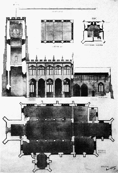
Fig. 11. Northleach church: cross-section on line of N. arcade, and ground plan, 1923
The nave of the church was remodelled in the mid 15th century, mainly at the expense of the woolman John Fortey (d. 1458), who bequeathed £300 to complete the work of the 'new middle aisle ... already begun by me'; (fn. 697) the south arcade was rebuilt, the north arcade was built or rebuilt, and a clerestory was added. The fourlight windows of the north aisle and clerestory are of similar design but those of the aisle are more heavily cusped and may have been completed first. The very tall five-bayed north and south arcades have hollowed polygonal piers with high bases and moulded capitals, continuing the form of the piers, and four-centred heads of multiple, hollow-chamfered orders; they are similar to the arcades at Chipping Campden and are also related to work at Winchcombe and All Souls', Oxford. (fn. 698) The roof is carried on corbels resting on shafts formed from the rere-arches of the clerestory windows, which rest on the arcade capitals. A very large window with a depressed head carries the clerestory over the chancel arch. The north aisle and the entire clerestory have embattled parapets, and the clerestory also has pinnacles. The north door has a four-centred head, continuously moulded jambs, and a hoodmould with head stops. Also in the mid 15th century the north chapel was built, and the chancel extended. The north chapel was said to belong to the parishioners c. 1703. (fn. 699)
The south chapel was built in 1489 by William Bicknell and his wife Margaret. (fn. 700) Bicknell was possibly lessee of the manorial demesne, which a Thomas Bicknell held shortly afterwards, (fn. 701) and rights in the chapel, which belonged to the Duttons in the 18th century, (fn. 702) presumably became attached to the manor of Eastington or specifically to its demesne farm. The chapel has a plain parapet with pinnacles, continuing that of the south aisle. The east window is similar to the clerestory windows, (fn. 703) but the south windows, which have heads like those of the south aisle, appear to be largely 19th-century restorations. The simple chamfered two-bayed arcade into the chancel has a very large rere-arch, and the opening from the south aisle has a four-centred head and an embattled string course on its south jamb. The east end of the south aisle, adjoining the Bicknell chapel, was also fitted as a chapel in the late Middle Ages, possibly for the chantry of St. Mary, mentioned above. On the east wall are the remains of an elaborate reredos with two tiers of recesses for statues, retaining traces of colour; near by is a statue niche of two depressed-headed blind panels in a square frame; and in the adjoining part of the south wall are an aumbry and pillar piscina.
The chancel also appears to have been remodelled in the mid or late 15th century, perhaps in conjunction with the work on the Bicknell chapel; it has windows of a similar pattern. The chancel arch has two chamfered dying orders, while the arch into the north chapel is of three chamfered orders which die into the wall over the opening from the former rood stair. The 15th-century sedilia in the chancel are possibly set into existing walling. Some minor work on the church continued in the early 16th century, when the east window of the north chapel was inserted.
A large west gallery was installed in the church before 1747 at the cost of the scholars of Northleach grammar school, (fn. 704) and in 1813 the church was furnished with 58 seats, appropriated to particular families, and the gallery was replaced with a new one to accommodate the poorer parishioners. (fn. 705) In 1884 a general restoration of the fabric and a refitting of the interior, including the replacement of some roof timbers, the removal of gallery and seats, and the provision of new pews and choir stalls (later moved to the north aisle), was carried out under the direction of James Brooks. (fn. 706) In 1897 the tower was restored. Further restoration work was carried out in 1902 with funds raised by subscription among leading county gentry as well as from local sources. (fn. 707) The church underwent a substantial re-ordering in the early 1960s: the west end of the chancel was fitted as the sanctuary, new seating designed by Sir Basil Spence and made by Gordon Russell was installed, and the chancel ceiling was replaced to the design of David Stratton-Davis. (fn. 708)
The church has an elaborate late 14th-century polygonal font, the decoration including portrait heads on the side panels of the bowl, angels playing musical instruments on the underside of the bowl, and devils being crushed at the base of the pedestal. (fn. 709) The 15th-century stone pulpit has been reset against the easternmost pier of the north arcade, where there was possibly once a tomb, as corbel heads survive half way up it and the next pier. The pulpit is goblet-shaped with a polygonal shaft similar to the arcade piers and blind tracery similar to the clerestory windows. Set in the side walls of the chancel are two carved stone croziers, presumably a reference to the insignia of the abbot of Gloucester, appropriator of the church and lord of Northleach. A medieval mensa, or altar slab, was found buried in the church in the late 19th century and was replaced in position in the chancel in 1902; (fn. 710) riddel posts with angels, designed by F. E. Howard, were added in 1923. (fn. 711) Fragments of 15th-century stained glass are reset in the heads of several of the aisle windows. Yellow stained glass inserted in the windows in the 19th century was replaced in several with plain glass at the restoration in the early 1960s, when a new east window, designed by Christopher Webb, was installed. (fn. 712)
The church contains one of the largest surviving collections of medieval brasses in England. Most of them commemorate 15th- and early 16th-century Northleach woolmen and have details which include Cotswold sheep, woolpacks, shepherds' crooks, and merchants' marks. Some have lost their inscriptions or are otherwise mutilated and most have been moved from their original positions at the restorations of the church. (fn. 713) Those commemorated are: a woolman and his wife in the dress of c. 1400; (fn. 714) the woolman Thomas Fortey (d. 1447), his wife Agnes, and her first husband, William Scors, a tailor; the woolman John Fortey (d. 1458), builder of the nave of the church; the woolman John Taylor (d. 1509) of Farmington and his wife Joan (d. 1510), whose brass appears to have been made before their deaths; (fn. 715) a woolman and his wife, who (as the brass has a merchant's mark incorporating the letter 'M') are likely to be William Midwinter (d. 1501) and his wife Agnes (d. c. 1503); (fn. 716) a mercer Robert Serche (d. 1502) and his wife Anne; (fn. 717) William Launder, vicar of Northleach from 1483 to his death c. 1524, (fn. 718) depicted kneeling at prayer; and the woolman Thomas Bush (d. 1525) and his wife Joan (d. 1526), whose elaborate brass incorporates the arms of the Calais staple, of which Thomas was a member. Also surviving, set in the wall of the south chapel, are fragments of the brass of the builders of that chapel, William Bicknell (d. 1500) and his wife Margaret (d. 1493), (fn. 719) and, in the north chapel, the matrix of a lost brass. A wall brass in the south chapel to Maud Parker (d. 1585), wife of Thomas Parker, farmer of the manorial demesne, (fn. 720) is inscribed with an acrostic poem incorporating the couple's names.
A peal of six bells was cast for the church in 1700 by William and Robert Corr of Aldbourne (Wilts.), perhaps at the cost of Sir Ralph Dutton, who is mentioned in an inscription on the tenor. To mark the royal jubilee of 1897 the peal was rehung and two more bells, cast by Mears and Stainbank of London, added, and in 1922 one of the old bells was recast. (fn. 721) The church plate includes an Elizabethan chalice made in 1569 or 1570, a paten cover of 1572 or 1573, an early 17th-century gilt cup given by Elizabeth Eames in 1707, and a new gilt flagon given in the same year by her sister Mary Parker. (fn. 722) An altar frontal made in the late 19th century from two bands of material of the Renaissance period (fn. 723) is framed on the wall of the south aisle. The churchyard monuments include some late 17th-century headstones and many of the 18th century, but all are much weathered. The registers survive from 1556 with some gaps in the early 18th century. (fn. 724) Travelling people who died while journeying through Northleach figure regularly among the burials in the 17th and 18th centuries. (fn. 725)
Nonconformity.
There was probably dissent from the established church at Northleach in 1639, when 13 men refused to pay church rates, (fn. 726) and 27 nonconformists were enumerated there in 1676. (fn. 727) In 1682 it was reported that 22 people did not come to church and that four refused to pay their Easter dues. (fn. 728) In 1735 10 Roman Catholics, 10 Presbyterians, and 5 Anabaptists were recorded at Northleach. (fn. 729)
The Congregational (or Independent) church at Northleach was evidently an offshoot of that at Pancakehill in Chedworth. In 1796 a group met in a room at Northleach belonging to William Wilson of Chedworth, and a new-built chapel opened at Antelope Close in West End in 1798 (fn. 730) was served in 1801 by the same minister as Pancakehill. (fn. 731) In 1851, when apparently still served from Chedworth, it had an average attendance of 80 at its evening service. (fn. 732) The chapel was replaced in 1860 by a new one built on the north-east side of the main street, facing the market place, with the Revd. R. B. Blanche as its minister. (fn. 733) In 1892 there was no settled minister and the chapel was served from Cheltenham. (fn. 734) By 1900, when the church had 28 members, there was a settled minister again, (fn. 735) and while one remained in post, until c. 1950, he also served the church at Chedworth. (fn. 736) In 1964 declining membership at Northleach and the chapel's need of extensive repair led to it being put up for sale and to services being held in the Cotswold Hall. Later, until 1969, meetings were held in the flat of one the few surviving members. (fn. 737) The chapel was later converted as a private house, preserving the narrow Gothic street front designed by J. R. Smith. (fn. 738) The burial ground at the site of the old chapel in West End remained in use by the congregation until the 1950s (fn. 739) and survived in 1997.
A group meeting at Northleach under a minister from Chalford in 1821 (fn. 740) were probably Wesleyan Methodists, who in 1827 opened a small new chapel at Millend. (fn. 741) The chapel ran a Sunday school by 1833. (fn. 742) In 1851 on the Sunday of the ecclesiastical census 100 people, including the Sunday scholars, attended its afternoon service and 114 its evening service. (fn. 743) It was then a part of the Cheltenham Wesleyan circuit and members of the Cheltenham church often walked over to Northleach to hold Sunday services. (fn. 744) Attendance later fell, partly as a result of the opening of the new Congregational church, and the Wesleyan chapel closed in 1883. (fn. 745) It was soon afterwards sold to the Primitive Methodists, who failed to sustain a membership at Northleach and sold it before 1889 to the Salvation Army, which also used it for only a short time. Before 1912 it passed to the Congregationalists who used it as an institute (fn. 746) until c. 1923. (fn. 747)
Education.
The principal school at Northleach was a grammar school, which was founded in 1559 by a wealthy local landowner and sheep farmer, Hugh Westwood of Chedworth, (fn. 748) and in 1606 placed under the patronage and rights of visitation of Queen's College, Oxford. Its history up to 1877, when it was reorganized under a Scheme of the Endowed Schools Commissioners, is given in an earlier volume. (fn. 749) In 1885, under its new governing body, which included representatives of the Northleach town charity trustees, it was teaching 30 boys on the foundation, together with some boarders; the endowment then produced an income of £708 a year. (fn. 750) The school was held in a building at the corner of High Street and Conduit Street (later Farmington Road) that had been acquired for it by the townspeople soon after 1560 under the terms of Westwood's will. (fn. 751) The boarders lodged at the headmaster's residence, College House, which is described above. (fn. 752) The school was closed by the governors c. 1912. (fn. 753)
Under a Scheme of 1926 the grammar school endowment was used in the establishment of a county council secondary school for Northleach and district called Westwood's Grammar school. That school, which was co-educational, opened in 1927 in new buildings at the south-east end of the town. (fn. 754) In 1984, when it remained a grammar school, it had 305 on its roll. (fn. 755) It was closed in 1988 and the pupils transferred to a new comprehensive school, the Cotswold school, at Bourton-on-the-Water. (fn. 756)
The original grammar school building at Farmington Road, much altered and enlarged, was used as offices by the Northleach rural district between 1949 (fn. 757) and 1974. The 20th-century school buildings at the south-east end of the town were replaced in the mid 1990s by a housing estate and leisure centre.
The wife of Sir John Atkinson (d. 1662) of Stowell (fn. 758) gave a meadow in Hampnett and 340 sheep-pastures, of a total value of £16 a year, to teach and apprentice eight poor children of Northleach. The gift was for a fixed term and the school, if ever established, lapsed during the 17th century. (fn. 759) Before his death in 1680 William Oldisworth of Fairford, who was lessee of the nearby manor of Coln Rogers, (fn. 760) supported a charity school for poor boys at Northleach, and in his will he instructed his sons to continue to pay £3 a year for teaching 6 boys reading, writing, and accounting. (fn. 761) Nothing further of that charity has been found, but George Townsend, who founded a number of charities including one to provide Oxford scholarships for boys from the Northleach grammar school, by will dated 1682 gave £4 a year for teaching Northleach children to read. (fn. 762) The endowment of Townsend's charities later increased in value, and by 1818 £10 a year each was paid to a master and mistress at Northleach, who were teaching 12 boys and 12 girls. (fn. 763) By 1868 the £20 was paid to the managers of the town's National school in respect of 24 children educated there free of charge. (fn. 764)
A school for the poor was opened at Northleach in 1831 in a new building paid for partly by a grant from the National Society. In 1833, supported by subscriptions and school pence, it had an attendance of 32 boys and girls. (fn. 765) In 1868 the National school was supported by voluntary contributions, pence, and the payment from the Townsend charity, the vicar supplying a deficiency in funds. (fn. 766) The building of a new school, on a site just outside the town, south of Millend, was begun in 1874; the site was given by Lord Sherborne and part of the cost was provided by the town charity trustees. (fn. 767) The school opened the following year with an attendance of c. 117. (fn. 768) It was enlarged to accommodate 200 children before 1897, when the average attendance was 144 in boys', girls', and infants' departments. (fn. 769) Average attendance at the school, called Northleach C. of E. school, remained at c. 140 during the early 20th century. (fn. 770) In 1997 it had 122 children on its roll. (fn. 771)
A church Sunday school was opened in or before 1801 (fn. 772) and one in connexion with the Wesleyan chapel before 1833. During the early 19th century the town and parish also had several small private schools. (fn. 773) A church school for Eastington was held in the new chapel built at Lower End before 1873 but it apparently did not survive the temporary closure of the chapel in the 1880s. (fn. 774)
Charities for the Poor.
About 1530 William King, who is described as of Hampnett but had probably been at one time undertenant of the Northleach manor farm, (fn. 775) gave a house in Northleach for use as a church house and market house. (fn. 776) Also, in what was apparently a separate gift in 1541 or 1542, King gave other houses to support loans to tradesmen, either young men starting out in business or old men whose businesses had failed, and with the profits from the property another house was later bought. (fn. 777) In 1602 12 leading burgesses were appointed in the town court to manage the property, (fn. 778) and in 1604 the court acquired a chest with three keys, to be kept by separate key holders, for storing the title deeds and the bonds which secured the tradesmen's loans. (fn. 779) It was decided that the interest received from the loans should be applied to the maintenance of the poor. (fn. 780) The town court subsequently administered King's charity together with other charities given later and other public assets under the general description of the town charities and town stock. The bailiff carried out the day-to-day administration and accounted to the court (fn. 781) and from the late 17th century he and the arbitrators granted leases of the property. (fn. 782)
William Dutton (d. 1618) of Sherborne left the building known as the Great House, together with £200, to his heirs and to the bailiff and leading townsmen to be let out to tradesmen who could put the poor to work, preferably in clothmaking; £4 of the annual profits he assigned as a direct dole to the poor. (fn. 783) The house and stock were assigned to two clothiers in 1631, (fn. 784) but by the mid 1640s the house was occupied by several different tenants and the stock was out on loan to five or more people. The donor's son John Dutton apparently thought that the charity was being misdirected in 1646 when he ordered the bailiff to bring him the bonds for the loans, and in 1650 he reserved the right to curtail a lease that the town granted of part of the house. (fn. 785) There is no evidence that the gift was used later to promote the cloth industry, though in 1670 the bailiff and court when granting a lease of the Great House to a single tenant made his tenure provisional in case a clothier should be found to take the house. (fn. 786) The house later became the Lamb inn and, after John Dutton (later Lord Sherborne) rebuilt it under a lease in 1818, it had the sign of the Sherborne Arms. The £200 was applied indiscriminately with the other town stock, (fn. 787) and in 1736 £80 of it was added to £100 given to the poor by Joshua Aylworth and used to buy a meadow of 8 a. in Hampnett; £4 a year from the rent of the meadow was later distributed to the poor in respect of Aylworth's £100 while the residue was applied with the rest of the town stock. (fn. 788)
William Edgeley, apparently in 1619, (fn. 789) gave the poor £15, which was used in 1628 to buy two burgages at Millend. It was intended to convert them as an almshouse for six inmates, but the scheme was conditional on acquiring additional property worth £10 a year as an endowment (fn. 790) and was apparently never implemented. The houses remained part of the town property and were on lease for 6 guineas a year in the 1820s. (fn. 791) The townspeople bought another house with £21 from the town stock in 1611 (fn. 792) and another in 1625 with £46, £20 of which derived from a gift by John Dutton of Sherborne. (fn. 793) Various sums were added to the town stock during the 17th and early 18th centuries, including £6 for loans to tradesmen given by Richard Hart in 1605 or 1606, two sums of £10 for the poor given by James Miller and his son John, (fn. 794) and £50 for apprenticeships left by Edward Carter (d. 1674), lord of Cold Aston manor. (fn. 795) The uses of the last gift were confirmed by the town court in 1726 and an apprenticeship was then made, (fn. 796) but later Carter's gift seems to have been applied indiscriminately with the other town charities. Other assets administered by the bailiff and court were, from the early 17th century, the common called Northleach Downs (fn. 797) and, from the mid 18th, the market tolls. (fn. 798) In the 1820s the real property they held produced an annual rental of £113, £70 of it coming from the Sherborne Arms and the meadow in Hampnett. (fn. 799)
The bulk of the profits of the town charities and stock appears to have been used in the same way as was laid down for William King's charity in 1604, regardless of the individual intentions of the donors. In 1610 seven sums of 20s.–40s., at that date all presumably deriving from King's charity property, were out on loan, but in 1685 a total of £216 was out on the security of 27 separate bonds. By 1701 sums of up to £25 were sometimes given to individual tradesmen and a total of £201 was then out on 22 bonds. (fn. 800) The tradesmen's loans were discontinued some time after 1745. (fn. 801) The direct aid given to the poor out of the town charities was mainly in the form of doles of bread in the 17th century. A system introduced in 1608 of maintaining four town almspeople, who were to attend church each Sunday and receive a 2d. loaf, (fn. 802) apparently gave way later to ad hoc doles of bread, (fn. 803) but in 1651 there was a regular system again under which six paupers received 1s. worth of bread from the bailiff in church each Sunday. (fn. 804) In the 1740s £2 12s. was expended each year in bread and the poor also received the £4 cash paid in respect of the Aylworth charity. (fn. 805) From the 1620s the bailiff and court also made grants to the town's overseers of the poor. (fn. 806)
In the 1830s disquiet over the uses to which the bailiff and feoffees applied the charity funds and a new responsibility they had assumed under the will of Mary Allen (described below) prompted reform of the town charities. Following an enquiry ordered by Chancery in 1831 the townspeople were allowed to make proposals for a new management scheme. That resulted in the creation of a new body of trustees who were to administer the old town charities and the Mary Allen charity in two separate accounts. The funds of the former were to be applied, subject to sums of £4 given to the poor in respect of the William Dutton and Joshua Aylworth bequests, to repairing the town property, paying off various loans (principally £500 which had been raised for buying out Lord Sherborne's lease of the Sherborne Arms), and building a new market house. After those obligations were met the trustees were to establish a school for the poor and provide other public buildings. A conveyance to new trustees under those terms was made in 1834. (fn. 807) The obligation to provide a new market house was dropped in 1858 and a scheme devised then to fund a middle-class school in connexion with the Northleach grammar school (fn. 808) was abandoned later. In 1859, however, the trustees, bought a house for use as a town reading room, (fn. 809) and in 1874 they provided £499 towards the cost of building the new National school. (fn. 810) In 1876, when the annual rental from property was £80 and the annual outgoings were the two sums of £4, then distributed in coal, £33 assigned to paying off a loan for the new school, and a variable sum for property maintenance, a good balance was being built up. (fn. 811)
In 1907 the assets of the town charities were £1,172 in stock, property producing a total annual rental of £51, and £275 cash in hand. A Scheme then created a separate educational foundation in support of the Northleach C. of E. school, endowed with the bulk of the stock and cash and administered by the trustees of the grammar school. By another Scheme in 1932 the town trustees took over the management of the Northleach almshouse of Thomas Dutton and they were empowered to devote their surplus income to the maintenance of that almshouse and one that they already administered as trustees of the Allen charity. A further Scheme of 1956 confirmed their powers to aid the almshouse charities and allowed them to use funds for other general purposes benefiting the town. It also created a new charity for the general benefit of the poor of the town, applying as an endowment £320 of the assets of the town charities and £360 of those of the Allen charity. (fn. 812) In the late 1990s the trustees used their income from the old town charities mainly to supplement the funds for the two almshouses; in 1998 the annual income was £2,634, derived from the rents of their two remaining properties, Northleach Downs and the meadow in Hampnett, and from stock. (fn. 813)
Thomas Dutton of Turkdean at his death in 1615 gave a house in East End at Northleach as the site for an almshouse for six inmates, each of whom was to have two rooms and a garden. For the maintenance of the building he gave a house in Oxford and to provide each almsperson with 20d. a week and a gown annually he planned an endowment of land worth £20, which he intended his brother and heir, William Dutton of Sherborne, would acquire using the profits of a manor in Turkdean. The almshouse was to be supervised by the bailiff, constables, and parish officers, who were to find suitable inmates, subject to the final choice of the Dutton family. (fn. 814) No estate was ever bought as an endowment nor were the profits of the house at Oxford apparently ever applied, but the Duttons of Sherborne paid for repairs to the building and the almspeople's weekly dole out of their estates in general. The almshouse seems to have been only for women until the 1820s when it was planned to admit men as well; their weekly doles were raised to 2s. under a bequest by Mary Allen. (fn. 815) Before 1932 the almshouse was endowed with £1,200 stock, presumably by one of the Lords Sherborne, and in that year it was transferred to the management of the town charity trustees. The Scheme of 1956 for the town charities provided that the six almspeople should contribute up to 5s. a week towards their support. (fn. 816) The almshouse, built on the southwest side of East End in or soon after 1615, is a gabled building with three entrances, each originally giving access to two lodgings. The interior was modernized in the early 1990s to accommodate four elderly residents, who paid the town charity trustees rents deemed appropriate under the 'fair rent' scheme. The other almshouse, that of the Allen charity, was modernized at the same time, and in 1998 the rents from both totalled £15,728; with £73 received in dividends from stock, the rent was applied by the trustees on paying off a large debt, incurred by the modernization of the two buildings, and paying fuel, water, and insurance bills. (fn. 817)
Mary Harritts Allen (d. 1817), widow of the Revd. John Allen, a former master of Northleach grammar school, (fn. 818) gave by her will the bulk of her possessions for charitable purposes in Northleach; her real estate was successfully claimed under the provisions of the Mortmain Act of 1736 by the heir-at-law but her personal estate, amounting in value to £3,100, came to the town. The will provided for the support of an almshouse for six men which, presumably by an earlier agreement, was to be built by the bailiff and leading townspeople. Her executors made a loan for that purpose to the townspeople, who completed and opened a row of six small cottages at Millend in 1818 and assigned a dole of 6s. a week to each inmate. Mary Allen also gave to the poor £4 in bread and £5 in fuel, added 4d. to the weekly dole of each of the Dutton almswomen, and gave £1 to the vicar or curate for a sermon. (fn. 819) Responsibility for the administration of the charity passed to the new town trustees in 1834. (fn. 820) In 1877, when the income of the Allen charity was £42 from stock and £18 from property, the almsmen each received 2s. 6d. a week and the other payments were made as laid down in the will. (fn. 821) In 1956 the endowment of the charity was £2,046 in stock, £360 of which was then applied to the new charity for the poor and £40 to support the payment for the sermon; from that time the occupants of the Allen almshouse were required to contribute up to 5s. a week. (fn. 822) In 1998 the almshouse was occupied by four tenants on the same basis as the Dutton almshouse. (fn. 823)
George Townsend (d. 1683) out of the same endowment he gave for a Northleach charity school provided for 1s. a week in bread for the poor and £5 a year each to Northleach and four other places for apprenticeships. (fn. 824) The charity's endowment was administered jointly for all the places benefiting, and in the early 19th century Northleach received an augmented sum of £15 for apprenticeships, besides the sum for bread; (fn. 825) the charity then usually apprenticed one Northleach child each year, generally to masters in the local area of the Cotswolds. (fn. 826) In 1973, when the endowment was divided among the places benefiting, Northleach was assigned £74 in stock, the proceeds of which were directed to the general benefit of the poor of Northleach with Eastington. (fn. 827)
Robert Charles (d. 1773) left 20s. in bread for the poor. The sum was later secured as a rent charge, (fn. 828) which was redeemed in 1968. John Harvey Ollney by will proved 1836 left £200 to Northleach to provide coal and blankets for the poor, and John Bedwell, a surgeon of the town, left £400 at his death c. 1890 to provide coal for the poor and Christmas dinner for the town's almspeople. By a Scheme of 1971 those three charities were amalgamated as a general relief in need charity to benefit the inhabitants of Northleach with Eastington. (fn. 829)
James Miles by will proved 1905 left money to be invested by the town charity trustees for the benefit of Eastington's agricultural workers and their widows aged over 60 in the form of coal or other provisions; that use was confirmed by the Scheme of 1956, when the charity had an endowment of £900 stock. Albert Teall (d. 1917) left property at Eastington, which realized a value of only £29, for the town charity trustees to distribute as they thought fit; the endowment, then £50 stock, was amalgamated with that of the town charities in 1956. (fn. 830)
A gift of 10s. in bread for the poor made by John Parker in 1692 could not be traced c. 1825, and a rent charge of 10s. for bread, given in 1771 by Simon Hughes, rector of Hampnett, was being paid then but was discontinued later. (fn. 831)