A History of the County of Wiltshire: Volume 12, Ramsbury and Selkley Hundreds; the Borough of Marlborough. Originally published by Victoria County History, London, 1983.
This free content was digitised by double rekeying. All rights reserved.
'Parishes: Ogbourne St. Andrew', in A History of the County of Wiltshire: Volume 12, Ramsbury and Selkley Hundreds; the Borough of Marlborough, (London, 1983) pp. 138-151. British History Online https://www.british-history.ac.uk/vch/wilts/vol12/pp138-151 [accessed 26 April 2024]
In this section
OGBOURNE ST. ANDREW
Ogbourne St. Andrew, 2, 180 ha. (5,387 a.), stretches west from the river Og across the downs north of Marlborough and Preshute. (fn. 1) An estate called Ogbourne existed c. 946 (fn. 2) and in the 11th century that name was borne by several holdings near the source of the river and along its valley. (fn. 3) Most of the lands of Ogbourne west of the river became part of Ogbourne St. Andrew, known in the 12th century as Little Ogbourne and later as South Ogbourne (fn. 4) to distinguish it from Ogbourne St. George, which lay chiefly east of the Og. To the lands of Ogbourne were added those of Rockley, which formed the western part of Ogbourne St. Andrew parish. Rockley may have included much of the downland between the Ogbournes and Hackpen Hill but by 1086 it had been divided into two estates. The eastern estate became part of Ogbourne St. Andrew parish, the western became part of Preshute parish as Temple Rockley manor. Land formerly in Ogbourne may have passed to Preshute after 1086, but it is not clear when the western boundary of Ogbourne St. Andrew, presumably marking that between the two estates, was firmly established. (fn. 5)
The modern western boundary runs north and north-east from the dry valley which marks the southern extent of the parish across Temple Bottom and Dean Bottom and then turns sharply north-west to Hackpen Hill. East of the hill fort called Barbury Castle the boundary with Ogbourne St. George follows Smeathe's Ridge and crosses Coombe Down, reaching the river almost halfway between the churches of St. Andrew and St. George. East of the Og it runs along the ridge above the valley and then descends to Bay Bridge. Within the boundaries are the townships of Ogbourne St. Andrew, Ogbourne Maizey, and Rockley, and the lands of Barbury farm. The largest township, Ogbourne St. Andrew, some 2,000 a. in the mid 19th century, included lands either side of the river beside the northern boundary. Ogbourne Maizey, south and west of Ogbourne St. Andrew, then included some 1,100 a., Barbury, in the north-west corner of the parish, 590 a., and Rockley, south of Barbury and west of the Ogbournes, some 1,500 a. (fn. 6)
The downs rise steeply in the north-west corner of the parish, reaching heights of 247 m. north of Four Mile Clump and 268 m. east of Barbury Castle. The chalk which outcrops over the whole parish is covered with clay-with-flints around the earthwork. The Og valley, below 137 m., is narrowest between the villages of Ogbourne St. Andrew and Ogbourne Maizey and widens near the parish boundaries. The dry valley which extends along the southern boundary divides 2 km. west of the river. One branch leads northwards east of Rockley village, others skirt Rough Hill as Temple and Wick Bottoms. That lying east of Rockley is sometimes watered by the Hungerbourne which rises below Barbury Castle. The stream, noted by Camden in 1609, flows more frequently from a spring at Rockley House and rose every three or four years in the early 20th century. It joins the Og at Bay Bridge. Gravel has been deposited in all the valleys and there is alluvium in the wider parts of that of the Og. (fn. 7)
Although prehistoric cultivation took place on the downs in the north part of the parish, (fn. 8) the lower ground was later used for arable and most of the downland for pasture. There was some downland arable, on the clay near Barbury Castle and on the lower slopes of Coombe Down, and in the 19th century more downland was brought under the plough. (fn. 9) Few references have been found to woods in the parish before the 19th century, when fir plantations were established. Of some 60 a. of woodland in 1839, 35 a., mostly planted with young firs, were around Rockley House and north of Rockley village (fn. 10) and the distribution of wood had changed little by 1980. Hare coursing took place at Rockley c. 1800 (fn. 11) and from the mid 19th century the downs east and north of that village were used as training gallops. (fn. 12)
In the 18th century the main route through the parish was the Swindon-Marlborough road, turnpiked in 1762. It entered the parish 500 m. east of Barbury Castle and ran south-east and then south to the Old Eagle, then an inn, 800 m. south-east of Rockley. Another north-south road, from Draycot Foliat to Marlborough, crossed the river a little south of the church. (fn. 13) Both were superseded by a Swindon-Marlborough road via Coate in Liddington, turnpiked in 1819, which followed the eastern bank of the Og to Bay Bridge. (fn. 14) In 1980 the two old roads survived as tracks north of the Old Eagle and of Ogbourne St. Andrew. The road from Marlborough to Wootton Bassett which ran from the Old Eagle across Rockley Down was turnpiked in 1809. (fn. 15) In the 18th and 19th centuries a road to Barbury Castle and Wroughton led north-west from that road 1 km. north of Rockley. (fn. 16) South of Barbury Castle Farm it was a track in 1980. Other tracks, most of them in the south and west parts of the parish, led from east to west across the downs in the late 18th century (fn. 17) and were still in use in the 20th century. They included the steep lane past the Old Eagle from Ogbourne Maizey to Rockley, which further west became a track leading to Top Temple in Preshute. The Swindon-Marlborough section of the Swindon, Marlborough & Andover Railway, built on the eastern slopes of the Og valley, was opened in 1881 and closed in 1964. (fn. 18)
The most notable archaeological site in the parish is the Iron-Age hill fort, Barbury Castle, the northern half of which lies in Wroughton. Near it are barrows and extensive earthworks indicating settlement continuing into historic times. The downs are generally rich in archaeological material. Late Bronze-Age earthworks and enclosures overlap the sites of field systems on Ogbourne Down and in Dean Bottom, and there are barrows on the surrounding downs. Ditches run from east to west north of Rockley and from north to south across Smeathe's Ridge and on Coombe Down. A bowl-barrow in Ogbourne St. Andrew churchyard was re-used in Roman, Pagan Saxon, and medieval times. (fn. 19)
If the tax assessments of the constituent townships of Ogbourne St. Andrew are considered together, the parish appears to have been one of the most highly rated in Selkley hundred in 1334. Similarly the total of 172 poll-tax payers in the parish in 1377 suggests a larger population than the average. (fn. 20) Tax assessments of the 16th century also were a little higher than average. (fn. 21) In the 1660s, however, there was plague in the parish and the inhabitants petitioned for exemption from a levy for the relief of Salisbury because of their own sufferings. (fn. 22) There were 434 inhabitants in 1801 and the population had risen to 511 by 1841. It had dropped to 386 by 1891 but was again above 400 in the early 20th century. Numbers declined from 422 in 1931 to 275 in 1971. (fn. 23)
Ogbourne St. Andrew village stands on the west bank of the Og 1 km. south of the parish boundary. The main street, some 400 m. long, was part of the road from Marlborough to Draycot Foliat. (fn. 24) It is joined to the SwindonMarlborough road, to which it is roughly parallel, by lanes which turn sharply east across the river at each end of the street. In 1377 Ogbourne St. Andrew was the most populous settlement in the parish. (fn. 25) Tax assessments of the 16th century were moderate or low compared with those of other communities in the hundred. (fn. 26) The original centre of the village may have been west of the street, where the church stands on rising ground. Beside the street are cottages of 17thcentury origin; most are timber-framed with brick nogging, partly replaced by sarsen. Two cottages on the west side of the street have walls partly of banded flint and stone with ashlar quoins. Substantial houses of the 18th and 19th centuries, standing opposite the lane which leads past the church, were at some time part of the principal farmstead. (fn. 27) The new turnpike road drew settlement eastward in the 19th century and infilling took place along the southern lane from the street and along the west side of the main road between Ogbourne St. Andrew and Ogbourne Maizey. (fn. 28) In 1841 the population was 166; (fn. 29) it may have increased slightly as building continued in the mid and late 19th century. Buildings of that period included the Baptist chapel, north of the southern lane, Tresco House, then the vicarage house, beside the road, (fn. 30) and the Wheatsheaf inn at the junction of the road and the lane. (fn. 31) Houses, including some council houses, were built east of the road in the 20th century. Other 20th-century buildings include a new farmhouse on the lane leading past the church towards Ogbourne Down, and houses beside the northern lane leading from the street.
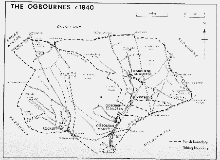
The Ogbournes c.1840
There is little evidence that Barbury, on the downs 500 m. south of Barbury Castle, was ever much more than a single farmstead. (fn. 32) In 1841 it had a population of 44 including an innkeeper. (fn. 33) In 1980 Barbury Castle Farm, a building of the 18th century or earlier, was approached by road from Wroughton.
Ogbourne Maizey stands west of the Og in the narrowest part of the river valley. In the Middle Ages it was a smaller settlement than Ogbourne St. Andrew; it was assessed for tax at 34s. in 1334 and had 50 poll-tax payers in 1377. (fn. 34) Tax assessments of the 16th century show it to have been one of the poorer communities of the hundred. (fn. 35) The older houses, including some 17th-century cottages, stand beside the lane to Rockley, which turns sharply south and west in the village. South of the lane and immediately west of the bridge over the Og is Ogbourne Maizey Manor. In the late 18th century the village was similar in size to Ogbourne St. Andrew and extended northwards beside the later Swindon-Marlborough road so that the two villages merged. (fn. 36) In 1841 the population of Ogbourne Maizey was 173 and it was the largest settlement in the parish. (fn. 37) New farm buildings south of the village were linked with the Swindon-Marlborough road by a bridge in the late 19th century (fn. 38) and c. 1900 the Bonita stables were built on steeply rising ground beside the lane to Rockley. (fn. 39) West of the village Maisey Farm was built on the crest of a hill 800 m. along the lane c. 1930. (fn. 40) Since the Second World War cottages have been demolished, there has been little new building, and the extent of the village in the 1970s was similar to that of the late 18th century. (fn. 41)
Rockley. When Rockley lay close to a major north-south route, the village may have been more important than in the 20th century. It was of sufficient substance to have been appointed the meeting place for the hundred court of Dunworth in the 13th century, although that appointment, which required the men of Dunworth to travel long distances, was one of several complaints laid against the deputy sheriff responsible. (fn. 42) In both the 14th and the 16th century Rockley was more highly rated for taxation than Ogbourne St. Andrew, perhaps because assessments of wealthy individuals were included. (fn. 43) There were 40 poll-tax payers in 1377. (fn. 44) The village was similar in size to Ogbourne St. Andrew and Ogbourne Maizey in the late 18th century. (fn. 45) It declined after the eastern SwindonMarlborough road was turnpiked (fn. 46) but the population was still 128 in 1841. (fn. 47) The Old Eagle at the junction of the former Swindon-Marlborough road and the road from Marlborough to Wootton Bassett has retained its name but was no longer in use as an inn in the mid 19th century. (fn. 48) There were several houses of the 19th and 20th centuries at the junction in 1980. The main part of the village is west of the road from Marlborough to Wootton Bassett, 2.5 km. west of Ogbourne Maizey in the valley watered intermittently by the Hungerbourne. Rockley House, Rockley Farm, and cottages of the 18th century are grouped north of a curving drive which was part of the road through the village until the late 18th century. In 1776 a new road was built 100 m. further south, (fn. 49) along which stand buildings mainly of the 19th century. They include the former school, the chapel, farm buildings, and cottages, one group of which bears the date 1897. Some 2 km. north-west of Rockley a white horse was cut in the chalk west of the road from Marlborough to Wootton Bassett, probably in the early 19th century. It became overgrown and was rediscovered in 1947. (fn. 50)
Manors and Other Estates.
Lands at Ogbourne devised by the ealdorman Athelwold to his brother Edric in 946–7 may have been in Ogbourne St. George or Ogbourne St. Andrew or both. (fn. 51)
The estate at Ogbourne held by Earl Harold in 1066 and by Miles Crispin in 1086 was probably the later manor of OGBOURNE ST. ANDREW. (fn. 52) On Miles's death it passed to his wife Maud of Wallingford. (fn. 53) The overlordship of the manor was part of the honor of Wallingford in 1242–3. (fn. 54) It descended with the honor until 1540 and thereafter with the honor of Ewelme. (fn. 55)
Between 1107 and 1133 Maud of Wallingford and Brian FitzCount, her second husband, gave the estate to provide clothing for the monks of the abbey of Bec-Hellouin (Eure). (fn. 56) A daughter house of Bec, Ogbourne priory, was established, probably at Ogbourne St. George, and endowed with the manor. The priory and manor were taken into royal keeping at various times in the 14th century during the wars with France. (fn. 57) In 1404 the keeping of the priory was granted to William de St. Vaast (d. 1404 or 1405), the last prior, Thomas Langley, dean of York, and John, duke of Bedford, (fn. 58) who was licensed to acquire the estates of the priory in 1410. (fn. 59) At the duke's death in 1435 Ogbourne St. Andrew reverted to the Crown and in 1437 it was granted to John St. Lo for life. (fn. 60) The reversion was granted to Cambridge University in 1439 (fn. 61) but was restored to the Crown in 1441. In that year it was included in the foundation grant to the college of St. Nicholas, later King's College, Cambridge. (fn. 62) Edward IV resumed the estates granted by his predecessor and omitted Ogbourne St. Andrew from those restored to the college in 1461. In 1462, presumably after the death of John St. Lo, he granted the manor to the London Charterhouse. (fn. 63) A commission was appointed by parliament in 1490 to determine the title to lands claimed by King's College and subject to dispute. Probably as a result of its findings, Ogbourne St. Andrew was held c. 1500 by the college, which paid a rent to the Charterhouse. (fn. 64) A similar arrangement was made in 1504 or 1505 (fn. 65) and in 1510 the college was licensed to pay £33 6s. 8d. yearly to the Charterhouse for the manors of Ogbourne St. Andrew and Ogbourne St. George. (fn. 66) The rent was extinguished at the Dissolution. (fn. 67) King's College sold its lands in Ogbourne St. Andrew in 1927. Poughcombe farm, some 405 a., was bought by W. H. Box who sold it to W. W. Saunders in 1928. (fn. 68) It was sold again in 1942 and 1959. In 1963 Mr. N. C. Naumann bought the farm, which he sold in 1977 to Hambro's Bank Executor Trustee Co. Ltd. (fn. 69) Upper Poughcombe, later New Barn, farm, 450 a., was bought in 1928 by Swindon corporation and sold to S. Maundrell c. 1935. It remained in the Maundrell family in 1980. (fn. 70)
Maud of Wallingford's gift of Ogbourne St. Andrew church to the abbey of Bec was confirmed c. 1148. (fn. 71) In 1192 or 1193 the abbey was licensed to appropriate the church (fn. 72) which became part of the endowment of the prebend of Ogbourne established in Salisbury cathedral for the abbot of Bec in 1208. (fn. 73) The prebendal estate, which included tithes and glebe in 1341 but later only tithes, passed with Ogbourne St. Andrew manor to John, duke of Bedford, (fn. 74) who granted it to the dean and canons of St. George's chapel, Windsor, in 1421. (fn. 75) The canons' tithes were commuted in 1839. (fn. 76)
Before 1147 Maud of Wallingford granted to her kinsman Richard 1 yardland in Ogbourne once held by his uncle Turga. (fn. 77) That may have been the basis of a second estate at Ogbourne St. Andrew held of the honor of Wallingford. Ralph Foliot (d. c. 1204) held an estate in Ogbourne of the honor in 1196. (fn. 78) He was succeeded by his brother Henry (d. 1233) (fn. 79) and by Henry's son Sir Sampson Foliot, mesne lord in 1242–3 and 1275. (fn. 80) After 1281 the mesne lordship passed with the manor of Draycot in Draycot Foliat to Henry Tyeys, Baron Tyeys (d. 1308). (fn. 81) On the execution of Henry's son Henry, Baron Tyeys, in 1321 it may have been forfeited to the Crown. (fn. 82) In 1231 William of Stoke had lands in one of the Ogbournes (fn. 83) and in 1242–3 he and Nicholas Crook held ½ knight's fee in Ogbourne St. Andrew of Sir Sampson Foliot. (fn. 84) By 1275 the estate had passed to Ingram de Waleys (fn. 85) who was succeeded by his son John in 1304. (fn. 86) It has not been traced further.
In 1780 Samuel Hawkes had a freehold estate of some 850 a. Its origins are obscure but it was probably formed by the consolidation and enfranchisement of copyholds of Ogbourne St. Andrew manor. (fn. 87) The estate was held c. 1796 by John Ward, husband of Hawkes's daughter Hannah. (fn. 88) It passed to their son T. R. Ward (fl. 1838) and grandson M. F. Ward (d. 1915). (fn. 89) In the 1930s the estate was bought by Whatley Bros., (fn. 90) and C. W. Whatley sold it to Mr. R. W. Margesson in 1946. In 1978 Mr. Margesson sold it as Ogbourne St. Andrew and Ogbourne Down farms to the Cadbury Schweppes pension fund. (fn. 91)
The endowments of a chantry founded in or before the late 14th century in Ogbourne St. George church (fn. 92) included 1 yardland and common pasture in Ogbourne St. Andrew in 1549. (fn. 93) The lands were sold by the Crown in 1550. (fn. 94)
The gift by Geoffrey son of Pain of lands at Barbury to the abbey of St. Georges de Boscherville near Rouen was confirmed in 1112–13. (fn. 95) The estate became part of the endowment of a priory founded at Avebury. After the suppression of that house, the lands passed in 1411 to Fotheringhay college (Northants.) and in 1545 to the Crown. (fn. 96) In 1547 the manor of BARBURY LEES was granted to Sir William Sharington (d. 1553). (fn. 97) Sharington was succeeded by his brother Henry (d. 1581). (fn. 98) The manor passed with that of Liddington to Henry's daughter Olive (d. 1646), wife of John Talbot, and to her grandson Sharington Talbot (d. 1677), whose son Sir John Talbot sold it in 1709 to John Churchill, duke of Marlborough. (fn. 99) It descended with the Marlborough title until 1877 when Barbury Castle farm was sold to Sir Henry Meux, Bt. (fn. 100) Meux was succeeded in 1883 by his son Sir Henry Bruce Meux (d. 1900), (fn. 101) whose relict sold the farm in 1906. (fn. 102) Members of the Redman family held the farm until 1936 when it was bought by J. W. W. Bridges. It was sold in 1942 to T. A. Sutton who was succeeded in 1945 by his son Mr. J. A. Sutton. Mr. Sutton was owner with his son Mr. C. A. Sutton in 1980. In 1979 some 94 a. were sold to Chiseldon Grain Dryers. (fn. 103)
Harding had lands at Ogbourne in 1066 and 1086. In 1086 Turchil held another estate there in which he had succeeded his father. (fn. 104) In 1242–3 Richard de Clare, earl of Gloucester and Hertford (d. 1262), held two estates in Ogbourne Maizey, possibly derived from those holdings. (fn. 105) They passed with the titles to Gilbert de Clare, earl of Gloucester and Hertford, on whose death in 1314 the overlordships passed to the Crown. (fn. 106) Both were held by William Poulton in 1428. (fn. 107) That of one estate belonged to the duchy of Lancaster in 1405 and to Philip Wroughton in 1462. (fn. 108) In 1242–3 Robert Marmium was mesne lord of that estate. (fn. 109)
The heirs of Robert de Maizey held OGBOURNE MAIZEY manor of Robert Marmium in 1242–3 and 1291. (fn. 110) In 1370 the manor was conveyed by William of Mere and his wife Catherine to William of Clyffe. (fn. 111) At his death in 1404 Peter Courteney held it in the right of his wife Margaret, daughter of John Clyvedon. (fn. 112) Margaret was succeeded in 1411 by her grandson William de Botreaux, Lord Botreaux. (fn. 113) On his death in 1462 the manor passed to his daughter Margaret, Baroness Botreaux, relict of Robert Hungerford, Lord Hungerford (d. 1459). (fn. 114) In 1469 that Margaret's granddaughter Frideswide Hungerford quitclaimed a share in the manor to Nicholas Hall. (fn. 115) The entire manor passed with Hall's manor of Bradford-on-Avon. Nicholas Hall (d. 1478) was succeeded by his sons Henry (fl. 1481) and Thomas (d. 1515). (fn. 116) The manor passed to Thomas's son William (d. 1550) and grandson Thomas Hall (d. before 1577), whose son John sold it in 1593 to John Cornwall. (fn. 117) After Cornwall's death in 1611 (fn. 118) it passed to his daughter Bridget (fl. 1629), (fn. 119) who was succeeded in or before 1638 by her son Sir William Master (d. 1662). (fn. 120) In 1712 the manor was held by Philip Ballard who sold it to John Pearce in 1717. (fn. 121) Pearce sold it in 1722 to Richard Stokes (d. 1723), whose relict Judith held it in 1740. (fn. 122) Their daughter Judith sold it to John Lydiard in 1743. Lydiard was succeeded in 1763 by his grandson the Revd. William Stratton Lydiard (fn. 123) who sold the manor in 1765 to George Spencer, duke of Marlborough. (fn. 124) It descended with the Marlborough title until 1820 when it was bought by Sir Hugh Smyth, Bt. In 1824 Smyth was succeeded by his brother Sir John (d. 1849). (fn. 125) In 1856 the manor was sold to John Tanner (fn. 126) who devised it by will proved 1859 to his son R. P. Tanner. (fn. 127) In 1893 it was bought by Frederick Lyneham who sold it before 1903 to George Edwardes, impresario of the Gaiety theatre in Aldwych, Westminster. On Edwardes's death in 1915 (fn. 128) his estate was divided between his daughters Dorothy and Nora. In 1948 the manor house and 550 a. were bought from Dorothy, wife of Cuthbert Sherbrooke, by Mr. A. C. Cooper, owner of the house and some 200 a. in 1980. In 1950 Mr. Cooper sold Maisey farm, 330 a., to Mr. Robert Curnick, the owner in 1980. Nora's portion was dispersed. (fn. 129)
Ogbourne Maizey Manor was built of banded sarsen and knapped flint with later additions in brick. There is a long main range with a central pedimented doorcase dated 1636. (fn. 130) A short back range formerly housed the kitchen. Many original stone-mullioned windows and some panelling survive but in the early 18th century the interior of the central part of the house was altered, a new staircase built, and some sash windows introduced. Extensive additions, which now house kitchens and service rooms, were made at the back in the 19th century.
The earl of Gloucester and Hertford's other estate at Ogbourne became the manor of EAST HAYES. It was held by Bartholomew de Emneberg in 1242–3 (fn. 131) and by Ellis Cotel in 1275. (fn. 132) The manor had passed to Walter Blake by 1316 and to Thomas Blake by 1428 when Thomas Seymour was named as a former holder. (fn. 133) John Blake was succeeded by his son William (d. c. 1550) and grandson William Blake. The younger William's relict Thomasine held the manor until her death c. 1573. The reversion passed to Nicholas Shipreve and Ralph Crook, nephew and grandnephew of the elder William. (fn. 134) William Goddard (d. 1603) bought Crook's reversionary interest in 1561 and Shipreve's moiety of the manor in 1573. (fn. 135) He was succeeded by his sons William (d. 1604), John (d. 1635), and Vincent (d. c. 1644), (fn. 136) and by Thomas Goddard, probably Vincent's nephew. By will dated 1653 Thomas devised the manor to Elizabeth Smith and Lucy Clarke, daughters of John Goddard (d. 1635), for life with reversion to his kinsman Edward Goddard of Hartham in Corsham. Edward inherited East Hayes in or before 1660 and was succeeded in 1676 by his son Edward (d. 1679). (fn. 137) The manor passed to that Edward's son John (d. before 1729) and granddaughter Elizabeth Goddard. Elizabeth, who married her cousin Edmund Goddard, sold the manor to William Lydiard in 1740. In 1760 Lydiard's son the Revd. William Stratton Lydiard inherited it (fn. 138) and thereafter it passed with Ogbourne Maizey manor.
Between 1449 and 1475 Isabel Bird endowed a chantry dedicated to St. Catherine in St. Peter's church, Marlborough, with a messuage in Ogbourne Maizey. (fn. 139) A messuage and 1 yardland, parcel of the chantry, were sold by the Crown in 1557 (fn. 140) and in 1558 were bought by Robert Drewe (d. 1575). (fn. 141) Nicholas Drewe (d. 1589) devised the lands to his wife Joan and daughters Joan, Dorothy, and Anne in succession. (fn. 142) The daughters, however, held them jointly. The three portions were acquired by John Hurlebatt, husband of the younger Joan, by inheritance or purchase and were sold by him to Thomas Goddard in 1614. The lands were then absorbed into East Hayes manor. (fn. 143)
The hospital of St. John the Baptist in Marlborough received 10s. rent for lands in Ogbourne St. Andrew in 1535. (fn. 144) The land passed to the Crown at the Dissolution and was granted to the mayor and burgesses of Marlborough in 1550 as part of the endowment of a grammar school there. (fn. 145) The holding, 26 a. in Ogbourne Maizey, was sold in 1650. (fn. 146)
Alfred of Marlborough held ROCKLEY in 1086. (fn. 147) The overlordship passed in the Tregoze family with the manor of Lydiard Tregoze and in 1302 it was part of the moiety of John Tregoze's estate allotted to Sir William de Grandison and his wife Sibyl. (fn. 148) Grandison (d. 1336) was succeeded by his sons Sir Peter (d. 1358) and John, bishop of Exeter. (fn. 149) In 1366 the bishop conveyed all his knights' fees in Wiltshire to Sir John Montagu. (fn. 150) Montagu was succeeded in 1390 by his son Sir John, later earl of Salisbury (d. 1400). (fn. 151) In 1538 a rent was paid for Rockley to Margaret Pole, countess of Salisbury. (fn. 152)
Hugh of Kilpeck had a house at Rockley in 1222 (fn. 153) and held the manor of Rockley in 1242–3. (fn. 154) He died in or before 1244 when the manor was granted to his relict Mazire as part of her portion. (fn. 155) In 1258, probably on Mazire's death, Hugh's estates were divided and Rockley was allotted to his daughter Isabel, wife of William Walerand, on payment of a rent to her sister Joan, wife of Philip Marmium. (fn. 156) Maud de Cauntelo held Rockley, perhaps as intermediate lord, in 1255. (fn. 157) Her grandson George de Cauntelo held the manor in 1268. (fn. 158) He was succeeded in 1274 by his sister Millicent, wife of Eudes de la Zouche. (fn. 159) In 1285 Millicent granted the manor to Elizabeth de la Zouche, perhaps her daughter, in return for an annuity. (fn. 160) Before 1301 Rockley passed to Nicholas Poyntz (d. c. 1311), who was succeeded by his son Sir Hugh (d. 1337). (fn. 161) Sir Hugh's son Nicholas conveyed it in 1351 to Sir Robert Russell (fl. 1395). (fn. 162) In 1397 Sir Ives FitzWarren and others, perhaps Russell's trustees, granted a moiety of the manor to Gilbert Newburgh and his wife Amice. (fn. 163) John Newburgh held the other moiety in 1412 (fn. 164) and the whole manor in 1428. (fn. 165) Newburgh or a descendant of the same name was succeeded in 1483 by a grandson John Newburgh. (fn. 166) On the younger John's death in 1486 the manor passed to his brother Sir Roger (fl. 1494). (fn. 167) It may have been sold in 1502 (fn. 168) and in or before 1509 it passed to Simon Green, whose son William inherited it in 1511. (fn. 169) In 1604 John Green, grandson and heir of Matthew Green, sold the manor to William Jones (d. 1611). (fn. 170) It passed to William's grandson William Jones (d. 1632) and great-grandson John Jones (fl. 1649). (fn. 171) In 1674 the manor was sold to William Grinfield (fl. 1685). (fn. 172) By will dated 1742 Edward Grinfield devised it to his son Steddy who sold it to the Revd. William Stratton Lydiard in 1775. (fn. 173) It passed with Ogbourne Maizey manor to John Tanner. (fn. 174) Tanner devised part of Rockley manor to his son William, (fn. 175) who apparently acquired the rest from his brother Robert. (fn. 176) William (d. before 1898) was survived by his wife Jane who sold the estate in 1911. (fn. 177) The manor house and some land were bought by H. de H. Whatton (d. 1926) (fn. 178) and passed through various hands until 1962. Mr. J. Lees-Millais then bought the house and 100 a. of land and in 1980 held 450 a. (fn. 179) In 1911 most of the land was bought by George Cowing whose executors sold it to Messrs. Hurditch and Harding of Portishead (Som., later Avon) in 1920. (fn. 180) In 1980 it was owned by Mereacre Ltd. (fn. 181)
Hugh of Kilpeck was granted timber to repair his house at Rockley in 1222, and in 1274 'certain buildings badly built' stood there. (fn. 182) Rockley Farm, a large timber-framed building of the 17th century or earlier, was derelict in 1980. It was probably superseded as the manor house by Rockley House. The east front of that house is of five bays with a central pediment and is in the style of the mid 18th century, but the decoration may be much later. The front appears to have been added to an earlier house to give symmetry; the addition may have been made when the house was extended westwards to make it almost square. The west side was probably further altered in the early 19th century when most of the roofs of the house were renewed. The many 20thcentury alterations include the removal of some original fittings, extensions on the north, west, and south sides, and general restoration of the 18th-century character of the house.
Robert of Ewias, to whom the estates of Alfred of Marlborough had passed, gave a hide in Rockley to the Templars in the 12th century. (fn. 183) The land apparently became part of their manor of Temple Rockley in Preshute. (fn. 184) In 1338 payment of 20 marks was made to the prior of Ogbourne for tithes, probably owed from the land formerly held by the Templars. (fn. 185) No other such payment is recorded and the land may thereafter have been considered part of Preshute parish.
A chantry founded at Bromham in 1494 by Sir Richard Beauchamp, Lord St. Amand, and his wife Anne was endowed with lands at Rockley. (fn. 186) They passed to the Crown at the Dissolution and were granted to Edward Carey in 1564. (fn. 187)
Economic History.
Ogbourne St. Andrew. There was land for 8 ploughteams on Miles Crispin's estate in 1086. The demesne was of 6 hides with 3 teams and 4 serfs. Another 3 teams were held by 11 villeins and 4 bordars. There were 8 a. of meadow and pasture ½ league long and ½ league broad. The estate was valued at £15 in 1066 and 1086. (fn. 188)
The open fields of Ogbourne St. Andrew probably lay on either side of the Og and the common pasture on the downs west of the river. There was an East field in the 16th century (fn. 189) and East, West, and South fields in the mid 17th. (fn. 190) Lord and tenants shared sheep pasture on Brinscombe, perhaps the later Coombe, Down from the 13th century to the 16th. (fn. 191) The farmer of the demesne of Ogbourne St. George had rights of pasture in Ogbourne St. Andrew and tenants from Ogbourne St. George worked lands in the Og valley south of the boundary between the parishes. Those rights probably derived from the common ownership of the manors of Ogbourne St. George and Ogbourne St. Andrew over a long period but may have predated it. Neither lord nor tenants of Ogbourne St. Andrew are known to have had equivalent rights in Ogbourne St. George. (fn. 192)
In the late 13th century the prior of Ogbourne had in hand 352 a. of arable in demesne, 8 a. of meadow, and common pasture for c. 1,000 sheep. (fn. 193) Much of the lord's income derived from corn, some £87 of the total of £114 in 1282. The income from sheep, however, may appear artificially low as some sheep were sold with those from Ogbourne St. George and their price was omitted from the total. (fn. 194) In 1294 there were 25 villeins who held 15 yardlands between them and 11 cottars who paid rents of 3s. 4d. each. (fn. 195) In the mid 13th century three cottars, all craftsmen, paid rents totalling 2s. The yardlanders then owed small money payments and three days work each week from Michaelmas to 1 August. During harvest they worked every day on the demesne. They performed the usual boonworks of ploughing and ploughed additional acres in return for herbage. Shearing and haymaking were done as the lord required. Exemption from certain works was granted for carrying services and threshing malt. Half-yardlanders owed half the services of yardlanders. (fn. 196) Labour services which already bore heavily upon the comparatively few tenants may have increased during the 13th century as exemptions in return for rents and special services were withdrawn. (fn. 197) In the 14th century there were repeated protests against the lord's demands. A writ was brought against the abbot of Bec in or before 1306 alleging that the manor was ancient demesne of the Crown and that yardlanders, who properly held by 5s. rent, 10d. woodgavel paid at Hocktide, and suit of court, had been compelled since the time of Edward I to do villein service including three days work each week. Although the courts found for the abbot, (fn. 198) the claim to ancient demesne was revived in 1332 and 1341. (fn. 199) In the 1330s the tenants resisted the abbot's servants by force, maintaining their cause from a common purse. (fn. 200) Rebellious tenants were fined and imprisoned and the lands of some were seized, but there were further disturbances in the 1340s, in 1389, and in 1416. (fn. 201) In the mid 15th century the demesne was leased with that of Ogbourne St. George manor. (fn. 202) Members of the Goddard family, lessees in the early 16th century, were succeeded by members of the Young and Bond families c. 1590–1685. The demesnes were still leased together in the 18th century. (fn. 203) The demesne lands of Ogbourne St. Andrew manor were known as Poughcombe farm from the 17th century. (fn. 204) In the mid 18th century that mainly several holding of 774 a. was worked from buildings on the east side of the village street, opposite the lane leading past the church. There were 221 a. of arable, mostly on the western slopes of Coombe Down. Near the river were 78 a. of meadow including Berry mead, formerly used in common. Sheep were pastured on 480 a. of Coombe Down. North-west of that pasture the farmer of Poughcombe had summer pasture for cattle on 409 a. of down, which were grazed by sheep from Ogbourne St. George in winter. (fn. 205)
Most, if not all, of the lands held by customary tenants of Ogbourne St. Andrew manor in the Middle Ages may have been shared in the 17th century between copyholders of inheritance and eleven copyholders for lives, known as corsiclemen. None of the corsiclemen had lands worth more than £4 a year. The copyholders of inheritance were more numerous and had larger holdings. (fn. 206) In the late 18th century there were no more than three copyholds. Many others had probably been absorbed into the substantial freehold estate then held by Samuel Hawkes which, with Poughcombe farm, included most of the lands of the township. (fn. 207)
In 1341 the prebendal estate included 2 yardlands, valued at 12s., and rents and services, valued at 6s. 8d. (fn. 208) The land was probably worked with the demesne land of Ogbourne St. Andrew manor (fn. 209) and may have been leased to the tenants of the demesne after 1421. In 1438 there were 28 a. of glebe arable and 2 a. of meadow. (fn. 210) From the mid 15th century the impropriate tithes of Ogbourne St. Andrew were leased with those of Ogbourne St. George. Members of the Goddard family were lessees from 1652 until c. 1680 (fn. 211) and from 1714 a lease passed in the Lydiard family, from 1740 with East Hayes manor. (fn. 212) The tithes were commuted to a rent charge of £830 in 1839. (fn. 213)
Except on Poughcombe farm common cultivation continued until c. 1,280 a. were inclosed by an award of 1780. Two large allotments were made, of 895 a. to Samuel Hawkes and 354 a. to King's College. Of the lands allotted to the college, c. 110 a. were attached to copyholds. (fn. 214) Much of the remainder may have been that part of the cow down, 235 a. in 1839, which was worked with Herdswick farm in Ogbourne St. George in the 19th and 20th centuries. (fn. 215) Poughcombe farm was little affected by the award. In the 19th century and the early 20th the farm measured 800–900 a., more than half of which was pasture, and was then worked from buildings north-west of the village, although there was no farmhouse until after 1858. (fn. 216) From 1800 until 1858 the farm was leased with the lands of Ogbourne St. George manor to members of the Canning family. (fn. 217) Members of the Gale family were lessees in the late 19th century and the early 20th when the farm was sometimes sublet. (fn. 218) When the farm was divided c. 1927 the northern part, Upper Poughcombe, included some 295 a. of down, 105 a. of lowland pasture, and only 50 a. of arable. Poughcombe farm included 141 a. of arable but was also mainly of pasture. (fn. 219) The other large farm in the parish, formerly Samuel Hawkes's, comprised 521 a. of down and lowland pasture, 468 a. of arable, and 49 a. of meadow land, including 17 a. of water meadows, in 1839. The arable lay either side of the Og and included burnbaked land on the downs east of the river. The land was worked from Upper and Lower Farms in Ogbourne St. Andrew and was held by lessees in the late 18th century and the 19th. (fn. 220) In the 20th century the land was divided into Ogbourne St. Andrew farm, 471 a., and Ogbourne Down farm, 404 a. Until 1969 Ogbourne St. Andrew farm was worked as a dairy farm. In 1980 the two farms and land outside the parish were worked together. There was some arable land and sheep and cattle were reared. (fn. 221)
At Barbury the prior of Avebury had 102 a. in demesne, valued at 34s., in 1294. Rents of 41s. 8d. were paid by five villeins, who held 4 yardlands, and two cottagers paid 3s. There was pasture for 300 sheep and the whole estate was valued at £5 8s. 4d. (fn. 222) From the 16th century or earlier Barbury was leased as a single farm, (fn. 223) until taken in hand briefly c. 1900. (fn. 224) In the 18th century the farmstead was 500 m. south-east of Barbury Castle and the lands lay in a semicircle around the earthwork with the pasture on the downs at the circumference. (fn. 225) There was grazing for 600 sheep in 1585. (fn. 226) In the 18th and 19th centuries almost half the farm of 590 a. was pasture, (fn. 227) and in the early 20th century there was only a small area of arable. Part of the land was then let as training gallops. (fn. 228) Since the 1930s much of the grass has been converted to arable. (fn. 229)
The mill which stood on Miles Crispin's estate in 1086, for which 30s. a year was paid, was one of the most valuable in the county. (fn. 230) Frequent references to mills and millers occur from the late 13th century to the 16th. (fn. 231) In 1294 there was a water mill on Ogbourne St. Andrew manor; (fn. 232) it is not clear how long that mill stood or when it was replaced by a windmill. In 1296 two tenants of the manor were amerced for having millstones in their houses to the detriment of the lord's mill. (fn. 233) In 1316 the miller was charged with grinding additional corn without licence. (fn. 234) In 1589 and probably earlier a mill was held as part of a copyhold of the manor. (fn. 235) That mill was probably the windmill at the east end of the churchyard said in 1760 to have been destroyed many years earlier. (fn. 236)
Ogbourne Maizey. Geld was paid for 5 hides from Harding's estate in 1066. In 1086 there was land for 3 ploughteams. On the demesne were 1 team and 1 serf, and 3 villeins and 4 bordars also had 1 team. There were 2 a. of meadow and pasture 2 furlongs long and 1 furlong broad. The estate was valued at £4. Turchil's was an estate of 2 hides, valued at 10s., with land for 1 team and 30 a. of pasture. (fn. 237)
From the 16th century or earlier open-field cultivation took place in East, South, and West fields and there was a common meadow west of the village, probably in the valley of the Hungerbourne. There was a large area of down in the township and sheep stints, reckoned at 80 to a yardland in the 16th century, were high. (fn. 238) Grazing for sheep on part, if not all, of the downland north and west of the village may have been shared with Rockley. In 1730 the boundary between Ogbourne Maizey and Rockley sheep downs was defined. It is not clear whether that was a new division or the re-establishment or adjustment of an existing one. (fn. 239)
The demesne farm of Ogbourne Maizey manor was of 4 yardlands in the late 16th century and was valued at £40 c. 1615. East Hayes was a farm of 10 yardlands, valued at £40 c. 1550. Both were leased in the 16th and 17th centuries. (fn. 240) There were then several copyholds, at least one of which was held of East Hayes manor, and all of which were apparently small. (fn. 241)
By an agreement of 1731, confirmed in 1740, the common fields and downs, some 1,000 a., were divided in 1735. (fn. 242) The allotment for the demesne farm of Ogbourne Maizey manor was of 339 a., including 197 a. of down. That for East Hayes manor was of 413 a., including 241 a. of down. Allotments of 176 a., including 105 a. of down, and of 56 a. of arable were made to copyholders. (fn. 243) By 1760 all those holdings had been amalgamated and in the late 18th century and the early 19th the land was worked as a single farm. (fn. 244) In 1839 it comprised 460 a. of pasture, 496 a. of arable, including 66 a. of ploughed downland, and 61 a. of meadow, of which 6 a. were water meadows beside the Og. (fn. 245) In the late 19th century new farm buildings were built on the down west of Ogbourne Maizey, the area of arable was extended, and a dairy herd introduced. The farm was in hand from 1893 to the 1920s. (fn. 246) Dorothy Sherbrooke's portion of it remained in hand until c. 1937. (fn. 247) It was then leased as Manor farm, c. 200 a., which was worked from buildings in the village, and Drove Barn, later Maisey, farm, 330 a. chiefly of downland. (fn. 248) Both Manor and Maisey farms were dairy farms until the 1960s when they became mainly arable. In 1980 some beef cattle were raised and commercial egg production took place on Maisey farm. Nora Edwardes's portion of Ogbourne Maizey farm was dispersed after 1915 and the lands worked with surrounding farms. (fn. 249)
Gallops on the downs between Ogbourne Maizey and Rockley were let to the tenants of Manton House stables in Preshute in the late 19th century. (fn. 250) A training stable was established at Ogbourne Maizey Manor by Frederick Lyneham in the 1890s (fn. 251) and another, Bonita, was built in or before 1903 for J. D. Edwardes. The stables were combined for some years but were managed separately from the 1930s. In 1980 Mr. A. R. Turnell trained at the Manor and Mr. P. Makins at Bonita. (fn. 252) The gallops, west of the village, ran parallel with the road from Marlborough to Wootton Bassett. (fn. 253)
Rockley. There was land for 6 ploughteams on Alfred of Marlborough's Rockley estate in 1086. The demesne was of 6 hides and 3 yardlands with 1 team and 1 serf: 3 teams were held by 7 villeins and 12 bordars and there were 3 a. of meadow and pasture ½ league long and 4 furlongs broad. The estate was valued at £8. (fn. 254)
In the 13th century much of the pasture of the township was several (fn. 255) but open-field cultivation continued until the 18th century. (fn. 256) The several pasture included 'Rothersdune', perhaps Rough Down, south of Ogbourne Maizey. (fn. 257) In the 18th century there was a common sheep down which bounded and may have been shared with Ogbourne Maizey. (fn. 258) The common arable lay in Dean and Temple Bottoms and probably in the valley of the Hungerbourne. Meadow land, much of which was divided into small closes in the 17th century, also lay in the valley. (fn. 259)
In the 13th century there was a large demesne farm and other small farms comprised 13 yardlands. The demesne included 432 a. of arable, several pasture for 200 sheep, 16 oxen, and 2 plough beasts, and another several pasture valued at 13s. 4d. Rents totalling 54s. were paid by villeins who held 9 yardlands between them and owed 2s. at harvest, three ploughworks, and two days weeding in the lord's corn. Two cottars owed 2s. in rent and three works in autumn. The yearly value of the manor was £16 3s. 7d. Six free tenants paid 25s. 8d. in rents; four were yardlanders, two held only crofts. (fn. 260) The men of Rockley owed services including ploughing, reaping, and carrying, to the barton estate of Marlborough Castle but in 1255 were said to have refused them for three years. (fn. 261) The holding granted to Bromham chantry, 32 a. of arable and 52 a. of pasture in 1494, was leased for 13s. 4d. as 1 yardland in 1563. (fn. 262) In the 17th century there were three farms. The demesne farm was said to include 200 a. of arable, 200 a. of pasture, and 20 a. of meadow. (fn. 263) There was a copyhold farm of 2½ yardlands including 72 a. of arable, pasture for 300 sheep, and closes of meadow, and another of 29 a. of arable and pasture for 100 sheep. (fn. 264) The three farms had rights on the sheep down in 1730 when the boundary was defined between the pastures of Rockley and Ogbourne Maizey. (fn. 265) The farms, which remained separate in the late 18th century, were in a single ownership and occupation in the early 19th and no inclosure award was therefore necessary. (fn. 266)
The Rockley estate was c. 1,330 a. in 1839. There were then 637 a. of downland on either side of the road from Marlborough to Wootton Bassett. (fn. 267) The proportion of pasture remained high although some downland was later ploughed. (fn. 268) From the late 18th century until the mid 19th Rockley House and between 40 a. and 80 a. were kept in hand or leased separately. (fn. 269) The remainder, 1,290 a. in 1845, was leased as Rockley farm to members of the Canning family. (fn. 270) It was in hand from c. 1867 to 1911. The land was then worked from Rockley Farm and farmsteads in Temple and Wick Bottoms. (fn. 271) The land in the western part of Rockley was later worked with land in Preshute as Temple farm, in 1980 by Mereacre Ltd. It was part of an extensive mixed farm with a principal farmstead in Rockley called Temple Farm, formerly Temple Bottom Farm. (fn. 272) In 1920 Rockley was a cattle and sheep farm of 750 a. of pasture and 133 a. of arable. (fn. 273) A farm of 450 a. was attached to Rockley House in 1980. (fn. 274)
In 1842 Rockley House and some 40 a. were leased to Edmund Jones, a racing trainer. (fn. 275) There was a racing stable adjoining the house in 1855. (fn. 276) Horses were still trained and bred there in 1911 but no later reference to the stable has been found. (fn. 277)
Spinners at Rockley were mentioned in the 18th century but nothing is known of their work. (fn. 278)
Sarsens were cut in Temple and Wick Bottoms by masons of the Cartwright family in the late 19th century. The supply of stone was exhausted c. 1905. (fn. 279)
Local Government.
Public and manorial business from Ogbourne St. Andrew township was transacted at courts held at Ogbourne St. George for the manors of Ogbourne St. Andrew and Ogbourne St. George. (fn. 280) Separate presentments from Ogbourne St. Andrew are not recorded before the 15th century. In the 15th, 16th, and 17th centuries a tithingman for Ogbourne St. Andrew was elected at the autumn court and made presentments. (fn. 281) Breaches of assize and manorial custom were the main business from the township. In 1249 the township was fined for failing to come to wash the lord's sheep. (fn. 282) Other offences included the omission of archery practice by inhabitants of the tithing in the 1590s. (fn. 283)
There is no evidence that representatives of the other townships in the parish attended the courts of Ogbourne St. Andrew manor and nothing is known of any court held for Ogbourne Maizey, Rockley, or Barbury. In 1281 quittance from suit at shire and hundred courts was claimed for Rockley manor, (fn. 284) but tithingmen from Rockley and Ogbourne, presumably Ogbourne Maizey, attended the hundred court in the 15th century. (fn. 285)
In 1776 the parish overseers bought a house to accommodate those unable to afford rents. Between 1770 and 1790 some £130 a year was spent on poor relief. In 1770 ordinary relief for 14–20 people each month cost the parish between £4 10s. and £6; another £4 a month was spent on extraordinary relief. (fn. 286) The average yearly expenditure rose to £352 in the 1830s. The parish joined Marlborough poor-law union in 1835. (fn. 287)
Churches.
Maud of Wallingford confirmed her gift of the church of Ogbourne St. Andrew to the abbey of Bec c. 1148. (fn. 288) After the appropriation of the church by the abbey in 1192–3 the living was served by a chaplain. (fn. 289) In 1208 a vicarage was ordained to which the abbot of Bec presented as prebendary of Ogbourne. (fn. 290) Under Edward I the prebendary received the right of archidiaconal jurisdiction in Ogbourne St. Andrew. (fn. 291) The exercise of that right by officials of the prior of Ogbourne and of the dean and canons of St. George's chapel, Windsor, or by lessees, is recorded from the 14th century to the mid 17th. (fn. 292) The Crown presented to the vicarage as keeper of Ogbourne priory in the 14th century, although the abbot of Bec sought to recover the patronage in 1335. (fn. 293) In 1421 the advowson passed with the prebendal estate to the dean and canons of St. George's chapel. (fn. 294) Grants of next presentation from the dean and canons allowed laymen to present to the living in 1565 and 1574. (fn. 295) The parish was served in plurality with Ogbourne St. George from 1951 (fn. 296) until the benefices were united in 1970 as the benefice of Ogbourne St. Andrew and St. George. In 1974 the united benefice became part of the Ridgeway team ministry. The rector of that ministry was thereafter appointed by a patronage board of five members including a representative of the dean and canons of Windsor. (fn. 297)
The vicarage of Ogbourne St. Andrew, valued at £4 13s. 4d. in 1291, was poor by comparison with others in the prebendal churches of the diocese. (fn. 298) In 1535, however, the vicar's yearly income of £15 12s. 10d. was above the average for Marlborough deanery. (fn. 299) The living was of moderate value, £160 a year, c. 1830. (fn. 300) The vicar received 2s. from the prior of Ogbourne on St. Andrew's day in the mid 13th century (fn. 301) and £20 a year in the 1660s from the dean and canons of St. George's chapel in augmentation of his income from tithes. (fn. 302) In the 15th century he held all tithes except those of corn, hay, wool, and lambs. In the 17th century, perhaps as a result of a grant from the dean and canons, the vicar also received wool and lamb tithes, except from Poughcombe and Rockley farms. (fn. 303) A yardland said to be part of the vicarage in 1588 may have been that held by the vicar as lessee from the Rockley chapel estate in 1563. (fn. 304) The vicar had no land except a garden and the churchyard in the 17th century. In 1650 he had a house with three rooms on each of its two storeys. (fn. 305) The house was described as a farm cottage, unfit for residence, in the early 19th century. A new brick vicarage house, hung with tiles above the ground floor, was built to designs by William Butterfield in 1848. (fn. 306) It was sold after 1951. (fn. 307)
In 1607 Obadiah Sedgewick, vicar of Ogbourne St. Andrew, was prosecuted for failing to wear the surplice and use the sign of the cross in baptism, (fn. 308) and Bartholomew Webb was ejected from the living in 1662. (fn. 309) In the early 19th century non-residence was common because of the condition of the vicarage house. (fn. 310) Some 100 people attended service at the parish church on Census Sunday in 1851. (fn. 311) In 1864 there were morning and afternoon services on Sundays. Communion was celebrated monthly and at the great festivals and was received by between eight and twelve communicants. (fn. 312) In the 1870s a succession of short incumbencies and unpopular clergy caused complaints from parishioners. (fn. 313)
The church had evidently been dedicated to ST. ANDREW by the late 13th century when the modern name of the parish was first used. (fn. 314) The church is built of sarsen and flint rubble with dressings of freestone and has a chancel, an aisled and clerestoried nave with a south porch, and a west tower which occupies the last bay of the nave. A new building may have been started when the church was granted to Bec abbey in the mid 12th century. (fn. 315) The nave and its arcades, which were presumably once of three bays but after the building of the tower of only two, survive from a church of that date and the reset north and south doorways were apparently built later in the 12th century, perhaps indicating slow progress in completing the aisles. A chancel arch was removed and the chancel rebuilt, presumably to align with the nave, in the early 13th century. In the early 14th century a new east window was inserted. Major alterations were made in the 15th century when the tower was built. Its intrusion into the nave was apparently necessary because the west end of the nave stood very near to the churchyard boundary. The clerestory was then added and both aisles were widened. Work of the 19th century includes the chancel roof, probably of 1873. (fn. 316) New pews were installed and the plain post-medieval south porch was rebuilt in 1914. (fn. 317)
In 1553, when 10 oz. of plate were confiscated, a chalice said to weigh 11 oz. was left in the parish. (fn. 318) In 1861 new plate was given to replace that destroyed by fire. (fn. 319) There were three bells in 1553. (fn. 320) A 15th-century bell, presumably one of them, survives. Three other bells, (i), (ii), and (iv), are of the 17th century and a fourth, (iii), of the 18th. (fn. 321) The parish registers are complete from 1538. (fn. 322)
In the 13th century there was a chapel at Rockley, the chancel of which was maintained by the prior of Ogbourne. (fn. 323) In the early 15th century it was dedicated to ST. LEONARD and served by a chaplain. No sacrament was administered there and the people of Rockley were required to attend the mother church at Ogbourne St. Andrew at festivals; in 1405 they were prosecuted in the prebendal court for failing to do so. (fn. 324) In 1563 the Crown granted a lease of the chapel and 1 yardland in Rockley, then held by the vicar of the parish. (fn. 325) By 1583 the building had been demolished and no later reference has been found to the land. (fn. 326) A house in Rockley served as a chapel of ease and was attended by 20 people on Census Sunday in 1851. (fn. 327) A new chapel was built in 1872 to designs by J. Baverstock of Marlborough. It is of flint and stone chequerwork with a chancel, nave, and south-west porch and was dedicated to ALL SAINTS. It was served by the vicar (fn. 328) until its closure in 1961, and was sold in 1973. (fn. 329) A chalice and paten of 1872 from Rockley were transferred to Ogbourne St. George church. There was one bell. (fn. 330)
Roman Catholicism.
A private chapel was built for George Edwardes at Ogbourne Maizey in 1911. It was served as a chapel of ease from St. Joseph's church, Devizes, until 1937 and then from Marlborough until 1970. The chapel, which stood opposite the Bonita stable beside the lane to Rockley, was demolished in 1970 or 1971. (fn. 331)
Protestant Nonconformity.
Bartholomew Webb, who was deprived of Ogbourne St. Andrew vicarage in 1662, continued to preach in the area until his death c. 1680. (fn. 332) In the 1660s and 1670s there were two or more Quaker families in the parish. (fn. 333) John Clark, founder of the Tabernacle church at Trowbridge, preached to spinners at Rockley in 1779. (fn. 334)
Methodist meeting houses in the parish were registered in 1817 and 1835. (fn. 335) In 1864 Primitive Methodists met in a private house. (fn. 336) A house at Rockley was registered for dissenters' meetings in 1818, and in 1820 there was an Independent chapel at Ogbourne St. Andrew. (fn. 337) The chapel was probably that known as the Zion chapel in 1858, (fn. 338) which was conveyed to the Particular Baptists in 1860. (fn. 339) In 1864 it had a small regular congregation. (fn. 340) It was closed in 1903. (fn. 341)
Education.
There were two private day schools in the parish in 1818 (fn. 342) but in 1833 most children from Ogbourne St. Andrew were said to attend schools in Marlborough. (fn. 343) In 1858 a National school, the origin of which is unknown, was held in a thatched cottage and had between 20 and 30 pupils. Some 35 children were then taught in a schoolroom attached to the Zion chapel; (fn. 344) nothing more is known of that school. A new National school with a teacher's house was built in 1872 and extended in 1896. (fn. 345) Average attendance rose from 61 in 1906 to 74 in 1914, but had fallen to 47 by 1932. (fn. 346) The school was closed in 1971 and the buildings were later used for a private nursery and primary school. Children from Ogbourne St. Andrew attended the primary school in Ogbourne St. George in 1980. (fn. 347)
A school was built at Rockley in 1868. (fn. 348) Attendance rose from 25 in 1906 (fn. 349) to 35 in the 1920s when some pupils came from downland farms in Preshute. Children were then sent to schools in Preshute and Ogbourne St. Andrew to relieve overcrowding at Rockley. (fn. 350) The school was closed in 1947. (fn. 351)
Charities for the Poor.
In 1776 money given to the poor by an unknown donor was invested to produce an income of 10s. a year. The proper beneficiaries were the second poor but in 1796, when the money was first used, food was distributed to all poor families of the parish. In the 19th century there were irregular distributions of fuel. The charity was known in 1905 as Canning's Trust or the Poor's Money. (fn. 352)
At inclosure in 1780 an allotment was made to the lord of Ogbourne St. Andrew manor of 5 a. on the downs in the north-west corner of the parish to raise furze or other fuel for poor parishioners. In the 19th century the land was leased and the annual rent of £4 was used to buy coal for poor householders, including those at Ogbourne Maizey and Rockley, or allowed to accumulate. (fn. 353) The land remained in trust for the poor. The income from the Poor's Furze and the Poor's Money was combined from the 1950s. In 1960 twelve people received 10s. each. In 1980 the money was used for any suitable charitable cause. (fn. 354)