A History of the County of York East Riding: Volume 1, the City of Kingston Upon Hull. Originally published by Victoria County History, London, 1969.
This free content was digitised by double rekeying. All rights reserved.
'Communications', in A History of the County of York East Riding: Volume 1, the City of Kingston Upon Hull, (London, 1969) pp. 387-397. British History Online https://www.british-history.ac.uk/vch/yorks/east/vol1/pp387-397 [accessed 26 April 2024]
In this section
COMMUNICATIONS
Ferries
Although the Rivers Hull and Humber brought undeniable advantages to Hull in the facilities which they provided for river transport, they nevertheless severely impeded the town's road communications. The River Hull obstructed travel to Holderness, and the Humber estuary blocked travel to the south. It was essential, therefore, to provide ferries from an early date.
There were ferries over the River Hull at both Stoneferry and Drypool by the 14th century. The earliest recorded name of the crossing at Stoneferry is 'Stanfordrak' in 1269. 'Stoneferry' occurs from the mid-14th century and suggests that a stonepaved ford there was replaced by a ferry, but the precise date at which this happened is not known. (fn. 1)
Further downstream at Drypool a ferry existed by 1273, crossing from land of the lords of Sutton on the east to land of Gilbert de Aton. Sir John de Sutton subsequently claimed that he had suffered by the grant of a ferry to the burgesses of Hull in the charter of 1299. It was found in 1307 that the burgesses no longer crossed in the accustomed place but 60 feet from it, and that the complainant did in fact suffer a financial loss. A further petition was lodged in 1332, (fn. 2) and it was found that his ferry had been worth £2 at the time the new ferry was established. (fn. 3) The precise location of Sutton's ferry is not certainly known.
In 1353 references are made to 'the North Ferry', presumably a designation applied to the ferry established in 1299 to distinguish it from the Humber ferry or 'South Ferry'. The corporation then paid the ferrymen a combined salary of £2. (fn. 4) In 1394–5 the ferryman was paid £3, (fn. 5) and this sum was paid regularly from 1424 until 1515–16. (fn. 6) In 1436–7 about £11 was spent on repairs to the boat, the building of a new one, and on repairs to the North Ferry Staith. (fn. 7) In 1454–5 £8 was spent on a new boat, (fn. 8) and in 1516 a vessel costing £110 called 'the Mary of the North Ferry' was launched. (fn. 9) The location of the ferry was in dispute in 1523 when the steward and receiver of Sir William Sydney forced a man to say that it was in the manor of Myton and not in Hull, although he later admitted to the corporation that he knew it was in the liberty of Hull. (fn. 10)
Presumably the ferry did not long survive the building of North Bridge in the mid-16th century. In 1608 a man was paid to dress and keep the staith 'at the North Ferry boat', (fn. 11) but there is nothing to suggest that the ferry was still in operation in 1610. About 1640 only 'the old ferry place' is shown. (fn. 12) The staith was reopened by the corporation in 1675 on the petition of inhabitants of the North End living near by. (fn. 13) In 1676 a temporary ferry was established from the Charterhouse (fn. 14) while North Bridge was rebuilt. (fn. 15)
Two other ferries over the River Hull are known. By 1823 a ferry existed from Garrison pier to the neighbourhood of Blackfriargate, near the mouth of the river. It was still in existence in 1856 but was presumably replaced by South Bridge. (fn. 16) A ferry known as 'the Brewhouse Wrack' is said to have operated in the 19th century between the Groves and Wincolmlee, serving in particular the cotton mills in the area. (fn. 17)
The ferry across the Humber has always been of greater significance to Hull's communications, providing the final link in the direct line of communication with London. Until the mid-19th century it was hazardous and uncertain, as some well-known travellers of the 17th and 18th centuries have testified. (fn. 18) The earliest crossings to have had a landfall close to Hull appear to have been the ferries from Barton and Barrow to Hessle, the first of which linked the road from London to that to Beverley and York. (fn. 19) In the 14th century the right to a ferry across the Humber became a source of dispute between the lords of Barrow and Barton which was not settled until 1371. A judgment was then given against a man who had set up a new private ferry with the assent of the lord of Barrow. The ferry from Barton was declared to be the exclusive passage from the coast of Lindsey with the exception of the original ferry from Barrow which was only for the inhabitants of that village. (fn. 20)
From the beginning of the 14th century a more direct communication between Hull and Lincolnshire became necessary. The need was expressed in 1308 when John Rotenhering applied for a 'new' passage from Hull to Lindsey. It was found that this would be worth about 6s. 8d. a year, but that the cost of establishing it would be heavy. There is no evidence, however, that further action was taken. (fn. 21)
In 1315, following complaints of extortion on the ferry between Hessle and Barton, the king ordered that only the customary dues of ½d. for a pedestrian and 1d. for a horseman should be exacted. (fn. 22) Later that year it was found that the proposed ferry from Hull would be worth £1. (fn. 23) In August the ferry was established to run from Hull to Lincolnshire and back, charging tolls for the king's use on pedestrians, horsemen, carts, and animals. The keeper of the town was to answer for the tolls annually at the Exchequer. (fn. 24) It became known as the South Ferry from the middle of the century. (fn. 25) In 1393 the town council complained to the king that the Barton ferryman was interfering with the ferry from Hull, and he was ordered at once to desist. (fn. 26)
It is not certain by what method the town originally managed the ferry. It was let in 1356, however, and from 1394–5 until 1481–2 the lessees paid a portion of the receipts from it to the chamberlains. (fn. 27) From 1482–3 onwards it was let at a fixed rent. (fn. 28) The ferry comprised a sailing-ship and a cog, or small boat. (fn. 29) New ferry-boats were built in 1424–5, 1451–2, 1468–9, and 1541. (fn. 30)
A ferry of cogs between Hull and Goxhill and Hull and Barrow existed as early as 1406. (fn. 31) After 1436 the profits were accounted regularly to the chamberlains. (fn. 32) Cogs and South Ferry were frequently managed by the same tenant. (fn. 33) In the 16th century the corporation itself also owned a boat or barge which it used to carry distinguished visitors to and from Barton; it was sold in 1577. (fn. 34)
During the 17th century the efficiency of the ferry was frequently criticized. (fn. 35) The lease changed hands often, the rent rose, (fn. 36) and in 1656 fares were increased for the first time since its foundation. (fn. 37) There was friction between the lessees and private boatmen who carried passengers to Lincolnshire, and rivalry between the crews of the Hull and Barton boats. (fn. 38) Throughout the century safeguards for the better running of the ferry were written into the tenants' leases. The lessee had at first to pay a sum to the market-keeper in lieu of toll on the livestock he carried, but this was discontinued after 1641. He was also responsible for the upkeep of the mooringposts of his vessels in the harbour and of the Horse Staith, their usual landing-place. From 1640 he was required to provide six men to man the vessels and from 1667 to take one vessel across on every tide. In 1673 the corporation proposed that a small crane should be installed at the Horse Staith to remove coaches from the sailing-ship, and in 1672 it ordered an abstract of the lease of the ferry to be displayed there. After 1698 colours were flown when the mayor and aldermen were carried, and a skiff was provided at Barton to help to land passengers. (fn. 39)
During the 18th century the rent of the ferry rose from £30 in 1719 to £300 in 1813, although the second sum includes the rent of the lessee's house at the South End. (fn. 40) The efficiency of the ferry, however, remained at its former low level, and in 1795 the corporation was forced to withdraw its lease from an unpopular tenant. (fn. 41) By 1752 a new boat or hoy had been built by the lessee at his own expense for the use of the foot passengers only. They were carried in it at the usual rates. (fn. 42) In 1780, however, the fare for inhabitants of Hull was raised following an agreement between the corporation and the tenant of the Barton ferry. This also required the ferrymen of Hull who took passengers from Barton to Hull to pay a proportion of the fare to the Barton ferrymen and vice versa. (fn. 43) The overlapping interests of the ferries were again in dispute, however, in 1787 and 1789. (fn. 44) In 1788 the lessee agreed to build a new hoy and in 1815 the fare for passengers in it was raised 'to exclude the lower orders'. (fn. 45)
Plans for the provision of more adequate landing facilities were made in 1770, (fn. 46) but their execution was probably delayed by the construction of the first Hull dock. In 1799, however, the corporation negotiated with the Crown for the purchase of part of the Artillery Ground to improve the streets approaching the South End, and to lengthen the South End jetty to form a dock for the ferry. (fn. 47) Negotiations dragged on until 1801 when the price of £2,400 was agreed, and the Ferry Boat Dock Act was secured. The work took the form of a pier, built parallel to the Humber shore, which protected landings from rough seas. (fn. 48) In 1805 a dock-master was appointed. Mud and warp impeded the use of the dock at an early stage and long remained an obstacle, while the superstructure required frequent repair. Indeed the ferry returned briefly to the old landing-place in 1808, but this in turn became a hazard as silt gradually accumulated around the jetty. (fn. 49)
On several occasions in the 18th century the corporation had tried to acquire the lease of the ferries from Barton to Hull and Hessle. (fn. 50) In 1796 it purchased the lease of the Crown's tenant at Barton for about £3,000, (fn. 51) and in 1815 it leased both ferries on new terms. (fn. 52) In 1821 it let the ferries at a rent of £800 to a company which operated a coachservice between Barton and London. (fn. 53) The new lessees used a steamboat in place of the hoy. The new vessel, the Waterloo, made two trips daily. It was replaced in 1826 by the Royal Charter, 'a very superior boat'. The company acquired the right to carry the London mail to Hull in her from 1827, and the number of passages a day was increased accordingly to four. A sailing-ship, or 'horse-boat', carried passengers at the old rates but was used chiefly for livestock and heavy goods. (fn. 54)
The ferries faced competition from market boats which sailed from Goxhill, Barrow, and Wintering- ham; (fn. 55) from a boat-service which operated briefly from Barrow in 1792; (fn. 56) and from the steam-packet service on the Humber. In 1820 the corporation forbade private boats to carry passengers or goods. (fn. 57) In 1826, however, a privately-operated service began again at Barrow. The corporation was advised that it retained an exclusive right of ferryage under the grant of 1315 and the judgment of 1371, but only if it satisfied public demand by supplying boats to other parts of Lincolnshire as well as Barton. Failure to do this rendered it powerless to prevent private boat-owners from supplying the need themselves. The corporation apparently abandoned the idea of litigation and the Barrow ferry continued without hindrance. (fn. 58)
The ferries were threatened from a different quarter in 1831 when the radical editor of the Hull Portfolio, James Acland, attacked the corporation's monopolies, drawing particular attention to the ferries. He denounced the 1s. fare as illegal, producing evidence that it had been imposed by the corporation against legal advice, and refused to pay it. With the support of the mob and of many tradespeople he chartered a series of steamboats to sail between Hull and Barton at a fare of 4d., establishing a regular service on the Public Opinion. Rivalry between this vessel and the Royal Charter became violent, and collisions occurred as the ships raced to the landing-places. (fn. 59) The corporation felt obliged to support its lessees and an action for libel was brought against Acland. At the 'York ferry trial', however, the plaintiffs received only nominal costs, and the judge himself intimated that the 1s. fare was illegal. (fn. 60) The trial over, Acland's popularity waned as he was forced first to raise his fare to 6d. and then to withdraw the Public Opinion in disrepair. (fn. 61)
The corporation's lessees, who had complained of financial losses in 1828, were unable to pay their rent after 1831, although the corporation continued to pay its own rent to the Crown. (fn. 62) After considerable difficulty the ferry to Barton was let for a year at a nominal rent in 1834. (fn. 63) It was calculated at a public meeting in Barton, however, that the receipts of the ferries together would not clear £2,400 that year against expenses estimated at about £2,700. The fall in receipts was attributed primarily to the rivalry of the New Holland ferry. (fn. 64)
This last ferry may have been established about 1825 and consisted simply of a 'gold duster', or rowing-boat. It expanded rapidly, however, receiving abundant public support during Acland's agitation. By 1832 a steamboat, the Magna Carta, was making three crossings to Hull daily, with extra crossings on market-days. (fn. 65) It was joined by the Falcon in 1839. (fn. 66) The proprietors of the New Holland ferry bought out the Barrow ferry although they allowed it to operate as before. (fn. 67) In 1836 the London mails to Hull were transferred from the Barton to the New Holland ferry. (fn. 68) In 1845 it was acquired by the Great Grimsby and Sheffield Junction Railway, and in 1846 it was taken over by the Manchester, Sheffield and Lincolnshire Railway. (fn. 69) The Barton ferry continued to provide four crossings daily until 1851, but was then discontinued. An attempt to revive it in 1856 proved abortive. (fn. 70) The New Holland ferry was still operated by British Railways in 1965.
In 1847 the ferry pier was joined to the mainland by a platform, and thereafter landings were made on the river side of the pier. In 1877 a floating pontoon was attached to the pier, then known as the Victoria Pier. The present pontoon landing-stage was erected between 1934 and 1936. (fn. 71)
Bridges
The North Ferry over the River Hull was replaced by a bridge in 1541, built to give better access to the fortifications under construction on the east bank. (fn. 72) The initiative for the scheme came from the king who bore part of the cost. Money and labour were also contributed from the county of Hull and from Holderness, while the town accepted responsibility for the cost of future repairs. (fn. 73)
The original site of the bridge is uncertain. An undated plan of the eastern side of Hull, ascribed to the mid-16th century, (fn. 74) places it within the town walls, crossing to a point just north of the castle. On the town side it is approached through a narrow arch in a crenellated wall. The structure is in two sections, each standing on five sets of piles. They are joined by a central leaf, presumably a movable section which allowed ships from Beverley to sail beyond the bridge. Another undated plan, also ascribed to this period, shows in addition a second bridge beyond North Gate near the present North Bridge. (fn. 75) This is the site occupied by the single bridge shown on maps of c. 1588 (fn. 76) and later. It is conceivable, therefore, that a temporary bridge was constructed in 1541 near the castle and was replaced by a more permanent one beyond North Gate with which it coexisted for a short period. It has been suggested that during the coexistence of the permanent and temporary bridges the former was for convenience called 'North Bridge'. (fn. 77) Another possibility is that the designation 'North' was simply transferred from the ferry to the bridge which replaced it. The name, however, does not seem to have been in use before the 17th century. From 1546 onwards the corporation let the collection of tolls from ships passing through the bridge; the tollcollector was also responsible for the upkeep of the bridge. (fn. 78)
In Hollar's plan of c. 1640 the bridge is depicted with seven sets of piles and an elaborate parapet and breastwork, but the movable leaf is not indicated. Throughout the 17th century the bridge underwent frequent repairs and alterations, particularly at the east end. (fn. 79) In 1676 merchants and shipowners petitioned the corporation to widen the arches of the bridge so that vessels hitherto forced to careen and trim at the South End might do so above the bridge. The corporation agreed and rebuilt the bridge with two leaves instead of one, each approximately 30 feet wide. The following year a lane for cattle was made on the bridge. (fn. 80) The structure of the bridge appears to have been primarily of timber and iron, and it was tarred frequently in this and the following centuries. (fn. 81)
In 1719 the bridge was repaired extensively, and in 1738 brickwork was added to secure the ends. (fn. 82) From 1775 plans were produced for substantially altering or rebuilding the bridge in brick or stone, and in 1785 a stone bridge was erected. (fn. 83) It is shown on a map of 1800 with an elaborate hoisting mechanism. By 1788 the corporation had acquired from the Crown property at the east end of the bridge. This was converted into an approach road, (fn. 84) and in 1790 a house for the bridgemaster was built there. (fn. 85) The bridge was extensively altered and enlarged in 1832, and the approach road on the town side was improved. (fn. 86) In 1870 it was opened as a horizontal drawbridge with hydraulic lifting-gear. It was replaced in 1931 by the present bridge, operated electrically, which was erected about 30 yards further north with new approaches from George Street and Witham. (fn. 87)
Several schemes for a second bridge below North Bridge had been prepared in the 19th century, but their execution was delayed by the suit between the corporation and the Crown over the Citadel, and it was not until 1862 that an Act was obtained. This incorporated the Hull South Bridge Co. and empowered it to erect a bridge. (fn. 88) The bridge, built in 1865, crossed the river from Humber Street to Garrison Side. It was removed in 1934. (fn. 89) Drypool Bridge was opened in 1889; it was rebuilt between 1958 and 1961. (fn. 90) Four bridges have been built upstream from North Bridge. In 1875 Sculcoates Lane Bridge was opened. (fn. 91) Scott Street Bridge was opened in 1902, (fn. 92) Stoneferry Bridge in 1905, (fn. 93) and Sutton Road Bridge in 1939. (fn. 94)
A scheme for a bridge across the Humber was proposed in 1867 as a demonstration project by a French company seeking support for its plan to build a Channel bridge, but it was abandoned in 1868. (fn. 95) A scheme for a tunnel under the Humber was put forward in 1872 but nothing came of it. In 1929 plans for a bridge were again proposed, but a Bill presented in Parliament was withdrawn in 1933. (fn. 96) Public interest in the scheme revived in the fifties and culminated in the Humber Bridge Act of 1959, but the bridge has not yet been erected. (fn. 97)
Roads
The creation of Wyke upon Hull in the late 13th century may have resulted in the improvement of the roads in the locality, though rivers were probably the chief means of carrying Yorkshire's wool to the port. (fn. 98) Little is known of the early road pattern. A track apparently ran westwards along the banks of the Humber to Hessle, although it was subject to frequent inundations. (fn. 99) The nearest approach from the east seems to have been the way from Bilton to Drypool granted by Saer de Sutton to the nuns of Swine before 1260. This no doubt followed the line of the modern Holderness Road. (fn. 100)
The provision of a more adequate road-system was a corollary of the development of the port by Edward I after 1293. The grant by the monks of Meaux to the king of all their rights in Wyke included permission to take land from their holdings outside the town for the construction of approach roads 40 feet wide. (fn. 101) A valuation of the lands to be acquired for this purpose was made in 1293, the projected roads being to Beverley, Hessle, and York. (fn. 102)
Little progress seems to have been made, however, and in May and September 1302 inquisitions again were held to determine how roads might most advantageously be made. The first road was to run eastwards from the River Hull through Drypool and Southcoates, continuing, 40 feet wide, to Bilton Bridge, thus providing a link with Holderness. The second was to run from the river, through the town, and then to divide, one branch leading westwards towards Anlaby, the other north-westwards towards Beverley; the road westwards was eventually to join the highway from Hessle to Beverley. Both these roads were to be 60 feet wide. They were probably linked to the Holderness road by North Ferry. Work on these roads had begun by 1305 when 4 acres of land in Milncroft, outside the town on the northeast, were assigned for the making of the royal highways there. (fn. 103) On the east side of the river the Sutton family claimed compensation for 7 acres of land which was taken in Southcoates, (fn. 104) and tried to prevent people from crossing their land. (fn. 105) In the same year Gilbert de Aton sought recompense for land in Myton which had been appropriated for the road 'newly constructed for travellers from the wolds to the town of . . . Hull'. (fn. 106) As late as 1324–5 Thomas Wake was trying to stop the burgesses from carrying a new road, presumably that to Beverley, across his lands. (fn. 107)
Responsibility for the upkeep of the new roads fell on the parishes through which they passed, although the Mayor and aldermen of Hull took responsibility for them within the lordship of Myton, since this was part of Holy Trinity parish. Repairs were also effected by private acts of charity. The legacies of John Gregg (1437), Alice Bilton (1441), and the merchant Robert Holme (1450), are notable examples in the 15th century. (fn. 108) Such bequests appear occasionally in the 16th and 17th centuries also: Aldermen William Gee (1600) and Thomas Ferries (1631), for example, made substantial bequests for the repair of roads outside the town. (fn. 109)
The recurrent cause of most of the damage to the roads was flooding. In 1316 commissioners of sewers found the roads to Beverley and York impassable and ordered inter alia that the Anlaby road be raised 6 feet. (fn. 110) Repairs to this road were again necessary in 1375 and pavage for three years was granted to the Mayor of Hull and prominent inhabitants of Hessle, Swanland, and Anlaby. (fn. 111) The following year permission was granted to reduce the width of the road, said to be 40 feet, when a dike was constructed on the north side. (fn. 112) In 1373 pavage for three years was granted for the road from Burstwick to Hedon and Drypool, and it was alleged that the road was too 'deep and muddy' to be repaired. (fn. 113)
In 1577 the roads to Hull, in particular the Holderness road, were so bad that the corporation was forced to amass a store of corn to ensure that supplies were available in case of scarcity, (fn. 114) and in 1596 the roads to Anlaby and Hessle required extensive repair. In 1603 the corporation permitted the people of Drypool and Southcoates to make a collection in Hull towards the repair of the Holderness road. (fn. 115) The Anlaby road was extensively repaired between 1631 and 1636, but an unusual amount of flooding in 1646 made fresh repairs necessary. (fn. 116) During the rest of the 17th century and the early years of the 18th the corporation carried out intermittent repairs to the causeways immediately outside the town gates and in Myton. (fn. 117) From 1692 until 1713 the proceedings survive of special sessions of highways for the town and county of Hull. The justices appointed annually two surveyors for each county parish and six for Hull. In 1695 they reported that the 'great waters' in Anlaby and Hessle were dangerous to travellers. It was ordered that the area be drained and that Hessle and Anlaby be fined if the road was not improved for travellers by the following winter. (fn. 118)
During the 18th century Hull vigorously supported schemes to turnpike the radial roads of the town. (fn. 119) The road to Beverley was turnpiked in 1744 and the roads to Anlaby and Hedon in 1745. (fn. 120) The Corporation of Hull strenuously protected the interests of the town during the negotiations which preceded the setting up of trusts. It ensured, for example, that the Hull end of the Hull-Beverley road should be repaired as promptly as the Beverley end. Again, its support for the turnpiking of the Hedon road was won by the provision that turnpiking proposals should not extend to the streets of Hedon itself.
In the early 19th century the communications of Hull were improved by the turnpiking of two further roads. In 1825 the road to Hessle and Ferriby was turnpiked. (fn. 121) The corporation approved of the scheme but did not invest deeply in it. (fn. 122) In 1830 a trust was established to build a new road running directly from Hull to Hedon. This road was intended to shorten the old circuitous route through Preston, in view of the development of Drypool, the possibility of further eastward expansion along the Humber bank, and the need to link the agricultural area of south Holderness more directly with the markets of Hull. (fn. 123) The corporation received the scheme coolly at first, but it increased its investment in the trust in 1831 when work temporarily stopped for lack of funds. (fn. 124)
Later in the 19th century, as Hull's boundaries were extended, the terms on which trusts cared for the radial roads of the town were altered. In 1855, for example, it was agreed that the responsibility of the Hull, Preston, and Hedon trust and the Hull and North Ferriby trust for the sections of their roads within the borough of Hull should cease when continuous lines of houses had been built along those sections. (fn. 125) Nevertheless, by the 1870s toll-bars in the expanding suburban areas of Hull were found to hamper free movement, and until the abolition of the trusts they were a source of irritation to residents. (fn. 126)
By the end of the 18th century the turnpike roads carried the mail service, passenger-coach services, and carrier services to and from Hull. The earliest reference to the establishment of a postal service from London to Hull is in 1635 when proposals for a national 'staffeto', or packet post, recommended that horses be provided for carrying letters to towns like Hull 'which lie far off the main roads'. (fn. 127) The post to Hull established in 1644 went through Lincolnshire to cross the Humber by the ferry at Barton. (fn. 128) In 1788 a mail-coach service from York was established and John Palmer, the mail-coach pioneer, was made a freeman of the town for his services. (fn. 129) From 1827, however, the southern mails were brought by the ferry steam-packet from Barton and the York coach services carried only the northern and western mails. (fn. 130)
The passenger-coach services of Hull did not expand so rapidly nor extend so widely as those of York. (fn. 131) In 1791 the London coach left Barton waterside daily in conjunction with the ferry. A coach travelled to York twice daily, and coaches served Scarborough and Bridlington, with a restricted service to Scarborough in winter. Five coaches travelled to Beverley. (fn. 132) In 1811 the services to York increased and an alternative route to London via Doncaster in 36 hours was established. Bridlington, Patrington, Scarborough, and Wakefield were each served by one coach. Two ran to Cottingham and three to Beverley. (fn. 133) Services to Liverpool, Newcastle, and Sunderland appeared sporadically in the following two decades. (fn. 134) The number of coaches serving Scarborough had increased to four by 1831, and a seasonal service was commenced to Hornsea. (fn. 135)
In the next fifteen years coach services expanded swiftly but briefly to Leicester, Liverpool, Nottingham, Norwich, and Sheffield, and a seasonal service was established to Harrogate. (fn. 136) These more extensive services did not survive the competition of the railways, however, and by 1851 twelve coaches served a limited area including Cottingham, Hedon, Hornsea, North Cave, Patrington, and Roos. Omnibuses also served Hornsea, North Cave, and Welton. (fn. 137) By 1861 the number of coaches had decreased further, while the number of omnibus services increased to seven. (fn. 138) Thereafter omnibus, passengercart, and waggon services expanded and in 1885 served routes within the growing residential areas of Hull until horse trams, waggonettes, and electric trams replaced them. (fn. 139)
The chief coaching inns at the end of the 18th century were the 'Cross Keys' and the 'Rein Deer' (Market Place), the 'Cross Keys' (Whitefriargate), Moor's (Land of Green Ginger), and Welburn's (Lowgate). (fn. 140) Only the 'Cross Keys' and the 'Rein Deer' retained their importance by the 1830s. Much of the trade had by then gone to the 'Vittoria Tavern' (Queen Street), the 'Bull and Sun' (Mytongate), and the 'Black Horse' (Carr Lane). (fn. 141) The latter retained its coaching interest as late as the sixties. (fn. 142)
The number of carrier services based on Hull before the late 18th century is unknown, but by 1791 11 carriers served the villages and farms around the city. Many of the services were based on the 'Blue Bell' (High Street), the 'Blue Bell' (Market Place), the 'Coach and Horses' (Whitefriargate), and the 'Bull and Sun', the 'Black Swan', and the 'King's Head' (Mytongate). (fn. 143) The number of carriers had increased to 97 in 1811 and by 1851 approximately 160 were based on 30 inns. (fn. 144) Their numbers barely rose in the second half of the century, however, and firms specializing in carriage by rail and water or by waggon appeared, capable of distribution over a much wider area. Hull has remained, nevertheless, a focal point of the local carrying trade.
During the 20th century the road pattern has remained basically unchanged. The principal concern has been to ensure a smooth flow of traffic across the River Hull, through the city, and out along the radial roads. To this end fly-overs have replaced two of the old level crossings, (fn. 145) stretches of dual carriageway have been incorporated into the Beverley and Anlaby roads, and by-passes have been built to avoid the narrow streets of North Ferriby, Hessle, and Anlaby.
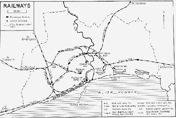
Railways (fn. 146)
The coming of the railways confronted Hull with the threat of competition from other ports no longer handicapped by their lack of inland waterways, and offered the promise of better land communications with the south and west. Railways were constructed subsequently in two roughly concentric arcs about the town. The completion of each of these marked a notable stage in Hull's attempts to meet the threat, and to capitalize on the promise. (fn. 147)
The first railway was that from Hull to Selby, (fn. 148) designed to join the Leeds and Selby line and so form a link with the West Riding. This line, opened in 1840, (fn. 149) carried 4,526 passengers in the first week. (fn. 150) By 1844 it had brought Hull to within 12½ hours of London, (fn. 151) and by 1849 express trains had reduced this to 10 hours. (fn. 152) The terminus for both passengers and goods occupied 5 acres of land facing Humber Dock, and had a frontage to the newly-constructed Railway Street. (fn. 153) There were single arrival and departure platforms, covered by a roof of three spans. At first trains stopped outside the station, the engine was detached, and the carriages were hauled into the platform by a rope. Eight turntables were needed to transfer the trains from the arrival to the departure side. (fn. 154) Cheap market tickets to Hull were issued within six months of the opening. (fn. 155)
The significance of the new railway as a crosscountry route was soon realized and the company was courted by similar interests in Manchester, (fn. 156) as well as by George Hudson, who controlled the York & North Midland and was determined to keep competitors from invading his area. (fn. 157) Overtures from the Leeds & Manchester led to a friendly alliance, (fn. 158) but Hudson had already acquired the small Leeds & Selby Company, (fn. 159) and he proceeded to put pressure on the Hull & Selby. He purchased the steam tugs which plied on the Humber between Hull and Selby, and ran them in competition with the new line. (fn. 160) By 1845 he had outbid the Leeds & Manchester, and in spite of opposition from the directors, who wished to maintain their independence, the shareholders of the Hull & Selby agreed to lease the line to the Y.N.M. with the option of purchase. (fn. 161) The lease was signed that year, (fn. 162) and in 1872 the railway was absorbed by the North Eastern, (fn. 163) which had been formed in 1854 by the amalgamation of the Y.N.M. and two other companies.
Whilst negotiations were in progress, the Hull & Selby had begun to build a branch to Bridlington. (fn. 164) This was opened in 1846, (fn. 165) and Hudson chose the occasion for a demonstration. He arrived from York, and a 'monster train' of 60 coaches, drawn by three engines, left for Bridlington. One of the engines appropriately named the Hudson less appropriately carried a name plate surmounted by a flag and the royal crown. (fn. 166) An undercurrent of distrust of the 'Royal George of York' can be detected in the speeches made at the banquet following the return journey. (fn. 167) It was a distrust which was to express itself in a number of abortive schemes, culminating finally in the Hull & Barnsley Railway of 1880.
With the opening of the Bridlington branch, the original station was found to be both inadequate and inconvenient. A new station, named after nearby Paragon Street, was designed by G. T. Andrews, George Hudson's architect, in 1846, and built in a more central position. (fn. 168) It had 'platforms equal to those at Derby and York', (fn. 169) and it was linked to the old line by 4½ miles of new railway. It covered 2½ acres and had a roof of three spans. (fn. 170) The station itself was opened without ceremony in 1848; (fn. 171) the adjoining hotel, although completed by 1849, was not opened until 1851. (fn. 172) No doubt Paragon was one of those buildings the erection of which brought a charge of 'wanton extravagance' at the inquiry of 1849. (fn. 173) The old terminus in Railway Street was converted into a goods station. (fn. 174) It was rebuilt in 1858, (fn. 175) and demolished in 1961. (fn. 176) In 1964 its site formed part of the Hull Central Goods Station, dealing with all kinds of freight. (fn. 177)
The lay-out of Paragon Station is similar to that of Andrews's earlier station at York (1841). (fn. 178) A range of buildings, one room deep, flanked the departure platform on the south side and contained the main station entrance from Anlaby Road. The hotel was placed at the head of the two platforms on the east, and was planned round a large internal court with a glazed roof over the ground floor. The buildings were designed in an Italian Renaissance style and constructed of ashlar masonry with slate roofs; the greater part of them survives unaltered externally.
The station buildings form a symmetrical composition consisting of a central booking-hall, of two stories and five bays, linked by single-storied wings, of eleven bays, to a two-storied 'pavilion', of three bays, at each end. The booking-hall has a portico with paired Doric columns supporting a Doric entablature and balustrade; it is now glazed to form an office. There are paired Ionic pilasters and pedimented windows to the first floor. The two wings each had a central Doric portico, supporting entablature and balustrade, but the portico on the west wing has been removed. Below the windows is a blind balustrade. The two pavilions have paired Doric pilasters to the ground floor supporting an entablature. The east pavilion and the two adjacent bays of the wing have been incorporated into a later extension of the hotel.
The hotel is linked to the east pavilion by an arcaded entrance to the station, and this feature, too, has been incorporated into the hotel extension. The east elevation to Paragon Square has two modern wings flanking the original three-storied hotel, which is of nine bays with the five central bays recessed. This centre has, on the ground floor, Doric pilasters enclosing an open arcade, and there are attached Ionic columns to the first floor. The original Doric portico has been removed from this front. The south elevation of the hotel is of ten bays: three have been removed for the modern extension of the east front, but the rest is unaltered and the details used on the east front are repeated here. The four central bays are recessed and arcaded on the ground and first floors. The original hipped roof has been removed and a fourth story added. (fn. 179)
In 1871 Paragon Station was dealing with 35 arrivals and 35 departures daily. (fn. 180) There were 505,022 passengers and 21,291 excursionists during 1873, the gross earnings being £92,525. (fn. 181) In 1903 the engine sheds were demolished and the station was extended towards Collier Street to form a new main entrance from Paragon Square. A new roof of five spans was erected, and new booking offices built. (fn. 182) A porte-cochère was erected on the east front; (fn. 183) this was demolished in 1960. (fn. 184) By July 1930 the station was dealing with 170 trains daily each way, and the estimated number of passengers in 1929 was 1,014,000. (fn. 185) The winter time-table for 1962 listed 158 daily arrivals and departures, (fn. 186) increased in the summer of 1963 to 184 arrivals and 173 departures. (fn. 187)
Railways
In 1848 the Manchester, Sheffield & Lincolnshire Railway reached Hull via the New Holland ferry. (fn. 188) This had been bought from one of its constituent companies in 1845, (fn. 189) and it replaced the ancient Barton ferry. (fn. 190) With the opening of the Great Northern to Peterborough in 1850, (fn. 191) the time to London by the ferry route, the East Lincolnshire, and the Great Northern main line was cut to just over 7 hours. (fn. 192) In 1856 the M.S.L. agreed to pay £40 a year to use the Corporation Pier at Hull. (fn. 193) In that year, too, there appears to have been an abortive attempt to reopen the older ferry. (fn. 194) The present 'station' at the pier-head was opened in 1880. The M.S.L. also operated a goods service by lighter from Lime Kiln Creek. (fn. 195) In 1879 a new warehouse, built by the North Eastern in Kingston Street, was opened by the M.S.L. (fn. 196)
In 1853 the Victoria Dock Railway, 3¼ miles in length, was opened. (fn. 197) This linked that dock to the older docks, west of the River Hull, and so completed the first railway girdle round the town. Built on the low level, the line crossed all the main roads into the town and was later to create serious traffic problems. (fn. 198) There were several suburban stations, of which Stepney and Southcoates were designed by a local architect, William Botterill. (fn. 199) This line had one of the earliest suburban passenger services in the country. From June 1853 to August 1854 the trains ran from the old Hull and Selby terminus to Victoria, a new station, built to the south of Hedon Road. They were later diverted to Paragon Station, but the service was withdrawn later in 1854, and the suburban stations were closed. (fn. 200)
The middle decades of the century saw two more coastal links established. The Hull & Holderness, (fn. 201) which opened in 1854, (fn. 202) was largely the work of Alderman A. Bannister, a Hull coal exporter. Designed to develop Withernsea as a resort, it carried 63,764 passengers in the first four months. (fn. 203) It was connected to the Victoria Dock line by a spur, and used Victoria Station as a terminus. (fn. 204) This arrangement was considered preferable to running the trains into Paragon. (fn. 205) The line was leased to the North Eastern in 1860 and absorbed by it in 1862. (fn. 206) The Hull & Hornsea, which opened in 1864, (fn. 207) was due almost entirely to the efforts of a Hull timber merchant, J. A. Wade. After running into financial difficulties it was merged with the North Eastern in 1866. (fn. 208) The line left the Victoria Dock branch at Wilmington, and upon amalgamation the trains of both lines used Paragon Station; in 1864 some of the suburban stations had been reopened. (fn. 209)
With the expanding trade of the port, facilities at the docks became increasingly inadequate, and the situation reached a climax with a complete breakdown in the movement of goods in 1872. (fn. 210) The North Eastern protested that it was quite capable of handling the traffic and laid the blame squarely on the Dock Company. (fn. 211) Nevertheless the confusion provoked further railway schemes, one of which, the Hull, South & West Junction, included a tunnel under the Humber. (fn. 212)
Another of these schemes included a deep-water dock, to be fed by a railway from south Yorkshire, which would exploit the coal trade of that area. It was projected by a London solicitor, Robert Galland, and enthusiastically supported by a Hull banker, Gerard Smith, and the Corporation of Hull. (fn. 213) Under the title of the Hull, Barnsley & West Riding Junction Railway and Dock Company, it was really a combination of the Hull & Barnsley Junction scheme of 1845, (fn. 214) and the Hull & West Yorkshire Junction of 1862, which provided for an independent entry into Hull. (fn. 215)
The promoters worked on the fears of Hull traders, pointing to the growth of Goole and Grimsby which had been fostered by railways. (fn. 216) The real underlying factor was the latent distrust of the North Eastern, a legacy from the days of George Hudson. Figures were produced to show that by quoting easier rates, the Hartlepools and the Tyne ports had been favoured at the expense of Hull. (fn. 217) Finally, local pride demanded that Hull, like other towns, should have an alternative line. (fn. 218)
A capital of £4,000,000 was issued and was soon oversubscribed. (fn. 219) An Act (fn. 220) was passed in 1880, and amid scenes of universal rejoicing Gerard Smith turned the first sod of the dock, during a snowstorm, in 1881. (fn. 221) Cutting through the chalk Wolds proved a formidable task and in 1884 funds were exhausted and the contractors ceased work. (fn. 222) Through the indulgence of Parliament an issue of £1,500,000 new capital was made, making this the largest scheme since 1850, and at £101,900 a mile the most expensive. (fn. 223) Work was resumed later in 1884, (fn. 224) and the railway was opened for both goods and passengers in 1885. (fn. 225) This completed Hull's second railway girdle, this time entirely on the high level.
William Shelford, the engineer of the line, proposed Kingston Square as the most suitable position for the terminus. (fn. 226) A bird's-eye view of Hull shows this proposed station resembling a red-brick version of St. Pancras. (fn. 227) The company, however, had to be content with a 'temporary' station at Cannon Street, Sculcoates, originally planned as a carriage shed. There were two departure and one arrival platforms, which dealt with thirteen trains each way when the line was opened. (fn. 228)
There was a suburban station at Beverley Road, and goods stations at Neptune Street, Cannon Street, and Sculcoates, with depots at Alexandra Dock, Ella Street, Burleigh Street (closed in 1952), and Dairycoates (closed in 1957). (fn. 229) The headquarter offices in Charlotte Street were bought for £7,500 from Henry Hodge in 1884. (fn. 230) The chief engine shed, together with the locomotive and carriage works, was at Springhead, 5 miles from Alexandra Dock. Outside firms built the rolling stock, but rebuilding and repair work were done under Matthew Stirling, son of Patrick Stirling of the Great Northern. He designed all but 53 of the final engine stock of 186. (fn. 231) Alexandra Dock also had an engine shed and in 1963 this housed diesel shunting locomotives. (fn. 232) In the early years of this century the railway had a small share in the emigrant traffic. Emigrants, chiefly from Russia, arrived at Alexandra Dock and left from a special station there for Liverpool, en route for America. (fn. 233) The North Eastern, which carried the bulk of this traffic, had to provide accommodation at Hull and special coaching stock to cope with it. (fn. 234)
The opening of the H.B.W.R.J. precipitated a war of rates between it, the North Eastern, and the Dock Company. In spite of optimistic forecasts the net revenue for the first five months was only £6,710, and by 1886 the company faced bankruptcy and an official receiver was appointed. Overtures for amalgamation were made to several companies but these were strongly opposed by the Corporation of Hull, which had invested £100,000 and sold land on condition that no agreement was entered into without its consent. (fn. 235) The Hull faction, which had the controlling voice, was, moreover, more interested in cheap transport than in earning dividends. (fn. 236) In 1891 the ordinary shareholders received their first dividend of 3/8 per cent. (fn. 237)
Parliament safeguarded H.B.W.R.J. interests in 1893, when the North Eastern purchased the Hull docks, and from 1899 there was a tacit agreement between the two railways. From that time the company's fortunes improved. (fn. 238) From 1903 dividends steadily rose until they reached 4½ per cent. in 1918– 20. (fn. 239) In 1905 Edward Watkin, nephew of Sir Edward Watkin of the M.S.L., became general manager. (fn. 240) In that year also the name was changed to the Hull & Barnsley Railway, (fn. 241) and an express to Sheffield was inaugurated in conjunction with the Midland. (fn. 242) This provided a connexion with routes to the south and west, and went towards fulfilling the forecast that the line would become the 'Hull and Everywhere Railway'. (fn. 243)
Amalgamation with the North Eastern, opposed by Hull Corporation, took place in 1922, a prelude to the general grouping which produced the L.N.E.R. in 1923. (fn. 244) In 1924 Cannon Street Station was closed to passengers, Beverley Road Station was closed entirely, and a spur was built to the Bridlington line to bring trains into Paragon Station. (fn. 245) Springhead became a wagon repair shop, which it still was in 1963. The headquarter offices became those of the L.N.E. District Operating and Motive Power Superintendents. From 1948, after the creation of British Railways, until 1962 this building also housed the District Goods Manager's office. The offices were partially destroyed by bombing in 1941 and were closed in 1962. A new building, Paragon House, was then opened over the forecourt of Paragon Station, and in 1964 this accommodated the offices of the Hull Division of the North Eastern Region of British Railways. (fn. 246)
The North Eastern had goods stations or depots at Railway Street (which in 1964 was known as Hull Central Goods Station, and dealt with all kinds of freight); Stepney and Drypool (which in 1964 dealt with station-to-station traffic in wagon loads); and Wilmington (which in 1964 dealt with full loads of station-to-station traffic). The Great Central had depots at Kingston Street and Lime Kiln Creek. The North Eastern had engine sheds at Dairycoates (in 1964 used for steam and diesel locomotives) and Botanic Gardens (in 1964 used for diesel multiple units). (fn. 247)
In 1952 a halt for football excursionists was opened at Boothferry Park on the Hull and Barnsley high level. (fn. 248) In 1962 a fly-over on Hessle Road was opened at Dairycoates. The H. & B. lines south of this point have been diverted to the former N.E. line. (fn. 249) This was the first stage in the elimination of Hull's level crossings. A second fly-over, on Anlaby Road, was opened in 1965. (fn. 250)
Passenger services on the H. & B. beyond Howden were withdrawn in 1932; they were totally withdrawn in 1955, (fn. 251) and the line was completely closed between Little Weighton and Wrangbrook Junction in 1959. (fn. 252) The line has been lifted in parts. The section between Springhead and Little Weighton was closed in 1964. (fn. 253) Under the Beeching Plan passenger services were withdrawn from Hornsea and Withernsea in 1964 and the Hull suburban stations closed. (fn. 254) A connecting link between the Bridlington and Leeds lines was opened in 1965. This eliminated a 1¼ mile stretch of the original Bridlington line and also three level crossings. The track has been lifted. (fn. 255)
Air Transport
Hull was among the first cities to establish a municipal airfield. In 1929 Hedon Racecourse and Twyers Farm, c. 200 acres in all, were acquired as a site, and the airfield was opened in that year. (fn. 256) It was requisitioned in 1939 by the Air Ministry. (fn. 257) In 1943 the corporation sought powers to re-establish air services as soon as the war ended, but nothing came of this. (fn. 258) The provision of air services to Hull was debated in the fifties and sixties, (fn. 259) and services to and from Brough airfield began in 1966. (fn. 260)