Survey of London: Volume 8, Shoreditch. Originally published by London County Council, London, 1922.
This free content was digitised by double rekeying. All rights reserved.
'Historical introduction: Hoxton, to the west of Hoxton Street', in Survey of London: Volume 8, Shoreditch, ed. James Bird (London, 1922), British History Online https://www.british-history.ac.uk/survey-london/vol8/pp72-88 [accessed 30 April 2025].
'Historical introduction: Hoxton, to the west of Hoxton Street', in Survey of London: Volume 8, Shoreditch. Edited by James Bird (London, 1922), British History Online, accessed April 30, 2025, https://www.british-history.ac.uk/survey-london/vol8/pp72-88.
"Historical introduction: Hoxton, to the west of Hoxton Street". Survey of London: Volume 8, Shoreditch. Ed. James Bird (London, 1922), British History Online. Web. 30 April 2025. https://www.british-history.ac.uk/survey-london/vol8/pp72-88.
(iii) Hoxton to the west of Hoxton Street.
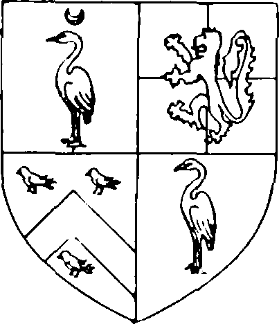
Starkey.
In the reign of Elizabeth the greater part of Hoxton west of Hoxton Street was included in three estates, belonging respectively to Sir Thomas Leigh, Sir Valentine Browne and the Haryong family.
The first had, a century before, been in the possession of Sir Humphrey Starkey (fn. 1), who, at his death in 1486, is said to have owned 3 messuages, 100 acres of land, 40 acres of meadow and 10 acres of pasture in Shoreditch, held of the bishop of London. (fn. 2). He left four daughters, (fn. 3) by whom the estate (or the greater portion of it) was sold to Sir Thomas Semer in 1525–6. (fn. 4)
Semer.
Semer died in 1535. (fn. 5) and in 1538 the property was transferred (fn. 6) from his son, Thomas, to Edward Elrington and Grace his wife. In 1553–4 Elrington sold (fn. 7) it (or a part of it) to Thomas (afterwards Sir Thomas) Leigh, (fn. 8) and on the latter's death on 17th November, 1571, he was found to have been possessed of a capital messuage and chief mansion house in "Hogeston" in his own tenure, all houses, barns, yards, etc., to the said capital messuage belonging, a garden, orchard, and little close in Hoxton called The Pingle, as well as a messuage and farmhouse in Hoxton, and all houses, gardens, etc., thereto belonging. (fn. 9)
Leigh.
Bond.
On 14th January, 1585–6, (fn. 10) Sir Thomas's widow agreed to convey the property to trustees for the use after her death of her daughter, Winifred Bond, (fn. 11) and in 1623 Thomas Bond, one of the sons of Lady Winifred, sold (fn. 12) it to Christopher Hewer and Thomas, his son. The elder Hewer died on 29th July, 1625, and on 26th February, 1625–6, Thomas also died. The inquisition (fn. 13) taken on the latter's property gives a full description of the estate. It contained:—
(i) A capital messuage, with chapel adjoining, lately in the tenure and occupation of Winifred, Lady Bond, widow.
(ii) A close of meadow and pasture called The Pingle (1 acre) on the west side of the messuage.
(iii) A close of land commonly called Brick Close (6¼ acres) abutting on the north side on the brick wall of the garden of the capital messuage, on Hoxton Street east, Old Street south, and the field called Pitfield west.
(iv) A close of land called Pale Close (4 acres) on the west side of the capital messuage.
(v) A close of meadow and pasture (10 acres) on the west side of the Pingle and Palecroft.
(vi) A messuage formerly in tenure of Margaret Burton, lately of Christopher Hewer and then of—Dashe.
(vii) Four cottages.
(viii) Six acres in the common field.
(ix) Four acres of land.
(x) A field called Pitfield (10 acres, 68 perches) then or late in the tenure of — Skingell, abutting on Brick Close, east, and Old Street, south.
Massie.
The property was said to be held of the bishop of London, and the next heir was John Massie, son of Jane, only daughter of Christopher Hewer. From John it passed to Robert Massie, and on the latter's death, to his son Edward, afterwards Sir Edward Massie, who disposed of the property in two lots. On 27th April, 1677, he sold (fn. 14) to Isaac Honywood (a) the "great messuage or tenement" formerly in tenure of William Dash, and then divided into three; (b) Pale Field, Pitfield, and Long Field, all adjoining one another and containing 28 acres. Long Field is obviously the name of the 10-acre close mentioned above. The Pingle also seems to have been included.
On 12th November, 1679, Massie sold the capital messuage and a field answering the description of Brick Close (and perhaps some other portions of the property (fn. 15) ) to Katherine Austen, from whom the premises passed successively to her son Thomas and grandson John. It will be convenient to deal with the Austen portion of the property first.
On 5th April, 1704, John Austen sold the capital messuage to Dr. Daniel Williams, (fn. 16) the founder of the Dr. Williams' Charity. From plans in the possession of the trustees of that charity the site of the house and appurtenances can be easily identified, within the angle formed by Hoxton Street and Fanshaw Street, extending as far as the eastern side of Short Street on the west, while its eastern boundary lay about 70 feet from Hoxton Street.
No mention of Brick Close by that name has been found later than the inquisition on Thos. Hewer in 1627. From the description of its situation as lying along Hoxton Street from the capital messuage to Old Street, however, it is clearly to be identified with the field known at the beginning of the 18th century as Church Field. (fn. 17) The southern portion of this field, extending from about 115 feet north of Hoxton Square, (fn. 18) was on October 19th, 1683 (fn. 19) let on lease to Samuel (afterwards Sir Samuel) Blewitt and Robert Hackshaw. The freehold continued in the Austen family until 1730, when Sir John Austen sold (fn. 20) to Israel Wilkes the younger (fn. 21) over 100 houses, including a Nonconformist chapel and The London Apprentice, all described as "in or near Hoxton Square, Hoxton Street and King Street."
We now return to that part of the Leigh estate which Sir Edward Massie sold to Isaac Honeywood in 1677. On 11th February, 1683–4, the latter let Pitfield in four portions to Anthony Ball and John Brown on a 900 years' lease for building. Three of the parcels were described as: (i) 320 feet on the south fronting Old Street, 352 feet on the north abutting on parcel (ii), 236 feet at the west end "on land lately belonging to Alexander Pitfeild and now or formerly used as a laystall," and 222 feet at the east end on parcel (iii) (fn. 22); (ii) 352 feet on the south abutting on parcel (i), 386 feet on the north abutting "on the ditch next and between the said close "('Pittfeild') and another field called Longfeild," 200 feet at the west end on lands now or late belonging to Alexander Pitfeild," 225 feet at the east end on parcel (iv) (fn. 23); (iii) fronting southwards on Old Street, 334 feet on the north abutting on parcel (iv), 222 feet at the west end on parcel (i), and 168 feet at the east end "on a feild or close or peice of ground lately belonging to Catherine Austen and then or then late lett by lease unto Samuel Blewett and Robert Hackshaw and intended to be built on." (fn. 24) Full details of the fourth parcel are lacking, but it included a portion on the north side of Queen Street (now Coronet Street) with depths of 91 feet and 87½ feet on the west and east sides respectively. (fn. 25) This evidently represented the northernmost extension of Pitfield, as the land further north is said to have belonged to Katherine Austen. From the above particulars, and with the knowledge that the land "formerly belonging to Alexander Pitfeild" was Laysterne Field, represented in Chassereau's Map by the six-acre field marked "Ashley Esq.," (fn. 26) the boundaries of Pitfield can be identified as—on the west the rear of the premises in Baches Street and Henson Street; south, Old Street; north, the line dividing premises in Charles Square (fn. 27) from those in Great Chart Street, continued east of Pitfield Street approximately 90 feet north of Coronet Street; east, the centre of Coronet Street extended to meet the northern boundary. Parcels (i) and (ii) were divided from (iii) and (iv) by the centre of Pitfield Street. (fn. 28) Ball and Brown, the owners of the long lease, endeavoured to establish a market on their property, and on 17th January, 1687–8, obtained a licence to hold two markets a week "apud Pitfeild prope Hogsden," namely, on Tuesdays and Saturdays, for the buying and selling of all kinds of flesh, fish and other provisions. (fn. 29) The project seems to have fallen through, and several references occur to "a parcell of ground lately used or intended to be used for a markett place called Hogsden Markett, but since converted into a square." (fn. 30) This is the origin of the square still called Hoxton Market.
On 13th June, 1690, Isaac Honeywood conveyed to Sir Peter Daniel and others, as trustees of the Haberdashers' Company, (i) the messuage of William Dash (then made into three messuages), (ii) Pale Field, and (iii) Long Field, all abutting east on land and houses of Mr. Blewitt (i.e., Church Field), north on a footway leading to Pimlico, and south on new buildings in Pitfield Street. (fn. 31) With the exception of the hospital and charity school, (fn. 32) the estate lay practically uncovered with buildings until the beginning of the 19th century, the first building lease, comprising the site of Haberdashers' Place, Aske Terrace and Haberdashers' Street, being granted in 1802. The general position of the estate is clearly shown on Chassereau's Map (Plate 1). Except in a few unimportant details, its boundaries are formed by East Road, Bevenden Street, Pimlico Walk, Short Street, the rear of the premises on the southern side of Ashford Street, Pitfield Street and the rear of the premises on the southern side of Great Chart Street and of Styman Street.
Browne.
We now come to the estate of Sir Valentine Browne. (fn. 33) The source whence, (fn. 34) and the date on which, Sir Valentine obtained it are not known, but as he is described as "of Hoxton" in an indenture of 20th September, 1575, (fn. 35) with Thos. Croker, the presumption is that he was then in occupation. A letter from him, addressed to Secretary Walsingham, and written from "Hoggesdon," is dated 12th August, 1583. (fn. 36) He died on 15th February, 1588–9, leaving "a capital messuage with appurtenances situated . . . in Hoggesdon alias Hockstone." (fn. 37) Sir Valentine, his son, died on 8th April, 1608. (fn. 38)
On 20th March, 1612–13, Thomas Nurse sold to William Johnson (fn. 39) "all that mansion house or capitall mesuage with appurtenances, scituate in Hoxstonne alias Hogsdonne . . . sometymes in the tenure . . . of Sir Nicholas Browne . . . that ys to say the mansion house or capitall mesuage, the moate, garden, courte yarde and all other the voyd roomes, voyd groundes and other edifices and buyldings whatsoever, as well without as within the compasse of the said moate in as large and ample manner as Sir Valentine Browne, knighte, now deceased, and the said Sir Nicholas Browne . . . enjoyed the same." Included were an orchard, adjoining the moat, walled about "partly with bricke and partly "with a wall of loome," a barn or stable with brickwalls, a yard adjoining the barn in the rear, "and all and every the edifices and buyldings of one gatehouse of tymber at the north end of the said barne or stable without the moate, which barne or gatehouse are adjoyning to the Kinges highway there." The property afterwards came into the hands of Sir Anthony Roper, at whose death, on 12th January, 1634–5, it was found (fn. 40) to consist of two messuages and divers lands, tenements and hereditaments, containing by estimation 60 acres at "Hoxton alias Hoggesdon," lately purchased from Sir Valentine Browne and William Johnson, and held of the Dean and Chapter of St. Paul's as of their prebend of Eald Street. On 22nd July, 1648, Henry Roper, brother of Sir Anthony, sold the estate to Charles (afterwards Sir Charles) Pitfield. It was said (fn. 41) to comprise:—
Roper.
(i) The capital messuage "sometymes in the occupacion of Joshua Hill and now or "late of John Brewer," and all the tenements, houses, barns, gardens, orchards, etc., thereto belonging, within and without the moat.
(ii) A close called Place Field (12 acres).
(iii) A close called Gore Close (8 acres).
(iv) A close called Abraham alias Apron Field (16 acres).
(v) A close called Pares Field (12 acres).
(vi) Three closes called Guyers Field, Bottom Field and Bull Field (31 acres).
In 1652, when the mansion house was occupied by Paul Tracy in virtue of a sub-lease made by Hill, a disastrous fire destroyed great part of it. As a result it lay waste for two years, while the moat, being unprotected, was a source of danger to the community, one man being actually drowned in it. (fn. 42) Sir Charles Pitfield died in 1680, (fn. 43) and his son Alexander succeeded to the property. A list of the rooms, etc., in the capital messuage "late the dwelling house of Sir Charles Pitfield" is extant, (fn. 44) from which the character of the house at this time can be gathered.
On Alexander's death, he was succeeded by his grandson Charles, the only son of Charles Pitfield, the elder, who had died before his father, leaving debts which for some time were a heavy burden on the estate. On 15th January, 1736, Charles the younger made a settlement of, inter alia, "all that the manor or reputed manor of Hoxton alias Hoggesdon." It comprised:—
Pitfield.
(i) The capital messuage then in occupation of Paul Hensch.
(ii) Farmhouse with barns, cowhouses, etc.
(iii) Place Field or Plane Field (12 acres).
(iv) Gyers Close or The Eight Acres (8 acres).
(v) Abraham alias Apram Field (16 acres).
(vi) Bottom Field and Bulls Field (17 acres).
(vii) The Fourteen Acres (14 acres).
(viii) Pax Field or Pars Field (12 acres).
(ix) Five acres in the common field.
(x) A close of meadow or pasture (4 acres) (fn. 45) "scituate near Bawmes house," purchased by Sir Chas. Pitfield of Sir Edward Massey, and two acres adjoining.
(xi) Crane Field "two acres whereof have been lately turned into garden ground and on them have been built lately three messuages or tenements now or late in the several tenures of Captain Smith, Mr. Capell and Mr. Sallee, and with the said Cranefield, are walled in and in lease to Ralph Harwood, Esq."
(xii) A close of meadow (3 acres).
(xiii) A number of houses.
Charles Pitfield died in 1740, leaving his property to his two daughters, Winifred and Mary (afterwards Mary Sturt (fn. 46) ). Fields (ii) to (viii) and (x) can be identified with those indicated on Chassereau's Map of 1745 as "Harvey, Esq.," (fn. 47) while Crane Field (xi) is the field marked "Harwood, Esq.," south of Hide Lane.
The site of Pitfield's mansion cannot be precisely identified. A list of occupiers in 1683 (fn. 48) shows Alexander "Pittfeild" as occupying a house at the northern extremity of the west side of Hoxton Street, and the Hearth Tax Rolls for 1666 (fn. 49) indicate that the house of "Chas. Pitfeild, Esq." (containing 13 hearths) was five houses north of The White Houses. A portion of these latter premises was sold in 1762 to George Brigenshaw and was then described as being on the north side of Constable's Alley (fn. 50) (now Hobb's Place). It would seem, therefore, that the only building which can possibly represent the Pitfield house in Chassereau is that situated (fn. 51) on the western corner of Hide Lane (Hyde Road) and the Path to Sir Geo. Whitmore's (St. John's Road).
It will have been seen that the above-mentioned property was described as "the manor or reputed manor" of Hoxton. It certainly, however, was not the manor of Hoxton, and, indeed, appears not to have been a manor at all. A detailed account of Hoxton Manor would be out of place in this volume, since it was situated within the parish of Hackney. Having regard, however, to its name and to the fact that a portion of it seems at some time to have been included in the parish of Shoreditch, (fn. 52) a short sketch of its history is here given.
The earliest definite mention of it that has been traced is in an indenture, (fn. 53) dated 6th October, 1351, of a lease by Sir John "de la Aspale" to Thomas Harewold of "tout son manoir de Hoggeston one les appurtenances en la paroche de Hakeneye." It had apparently been purchased with other property by Robert de Aspale in 1305–6 from John and Maud Birtecurte. (fn. 54)
Sir John died on 28th September, 1355, (fn. 55) and the next reference to the manor occurs in 1370–1, when it is found in the hands of Elizabeth de Aspale, (fn. 56) his widow. An indenture, dated 29th October, 1372, (fn. 57) shows that the manor of "Hoggeston," and other premises, all of which had been leased to the priory of St. Mary Spital for 10 years from Michaelmas, 1371, were sold by Elizabeth to John de Stodeye, Nicholas Brembre, John Birlyngham and Thomas Creyk.
The manor is next found in the possession of Sir John Philpot (or Phelipot) who died in 1384. By codicils to his will he provided (1) that Margaret his daughter was to have all the lands and tenements formerly belonging to John de Stodeye, (fn. 58) after the death of Margaret, his wife; (2) that Margaret his wife was to hold the place called "Hoggeston," for life, with remainder to his sons Thomas and Edward. (fn. 59)
The inference seems to be that Hoxton was not a part of the lands of John de Stodeye, otherwise it would be natural to connect it with the sale by Elizabeth de Aspale to John de Stodeye and others mentioned above.
The inquisition taken after Philpot's death (fn. 60) mentions that the manor of "Hoggesdon" was held of the bishop of London. It continued in the hands of the Philpot family until 20th June, 1634, when Sir John Philpot disposed of it (fn. 61) to Sir William Whitmore, Sir Samuel Sawyer and William Gibson, apparently as trustees for Sir George Whitmore. (fn. 62) In this transaction it is described as "the mannor or lordshipp of Bames." This name is first met with in the year 1509–10 when Peter Philpot, son and heir of Sir John Philpot, claimed livery of his father's lands, including "the manor of Hoggeston otherwais callid Bams." (fn. 63) This effectually disposes of the theory (fn. 64) that the name was derived from the circumstance that the manor house was built about 1540 by two Spanish merchants named Balms. The real origin of the name is unknown, but it is possible that it was derived from that of the family of Bamme, prominent London citizens in the late 14th and the 15th centuries, one of whom may have occupied it for some time. From Sir George Whitmore the manor descended to William Whitmore, after whose death it was sold by his trustees to Richard de Beauvoir, in 1687. (fn. 65) It remained in the possession of the De Beauvoir family throughout the 18th century. The only portions of the property in 1745 which lay in Shoreditch were two fields marked in Chassereau's Map "Bevoir Esq.," neither of which was a part of the original manor. (fn. 66)
Marow.
One of the most important houses in Hoxton in the 15th and 16th centuries was the residence of the Haryong family. (fn. 67) Robert "Heryong," (fn. 68) whose will (fn. 69) is dated 2nd May, 1500, provided that after the death of Margaret his wife, his son Richard should have "the grete place that John Heryonge my late fader, dwelled inne . . . with iij tenementes . . . gardens and berns down to the flode dyche." Richard died in 1545, (fn. 70) leaving a daughter Alice, married to Thomas Marow. On 9th February, 1612–13, the latter's grandson, Sir Edward Marow, sold (fn. 71) to Arthur Hollingworth, inter alia, "all that capitall mesuage and tenement garden and orchard . . . sett, scittuat and beinge in Hoxton . . . late in the tenure or occupacion of Sir Thomas Tressam, knight."
Tresham.
We first hear of Tresham (fn. 72) at Hoxton in 1583, when, after about 18 months' imprisonment in the Fleet, he was allowed a brief respite at Hoxton, where he was "badly lodged . . . his chamber being allotted over a noisome kitchen, rudely and disjoinedly boarded and not a whit ceiled." On 27th May, 1583, his wife wrote to her aunt, the countess of Bedford, asking that "he may be licensed to his house at Hogsdon, putting in band of 2,000l. not to depart forth of that house, enjoying therewithal a little orchard and less garden . . . it being the very next house where he now remaineth prisoner." (fn. 73) Presumably only part of this request was granted, for on 1st October he was still at Hoxton in a cottage which he described as "erst a tippling ale house." Numerous letters are extant from him or his wife written from Hoxton and dating from about this time until 1604.
There seems good reason to believe that during his lease the house was occupied for a time by his son-in-law, Lord Monteagle, (fn. 74) and it is more than likely therefore that this was the house where on 26th October, 1605, Monteagle received the warning which brought about the discovery of the Gunpowder Plot.
Parker (Monteagle).
The identification of the site of the house is not unattended with difficulty. The facts are as follows:—
(i) The indenture of 1613, between Sir Edward Marow and Arthur Hollingworth mentions (a) the Tresham house, (b) 2 acres in the common field of Hoxton, (c) a garden plot containing 1½ acres near the king's highway, (d) a messuage with close containing 2 acres late in occupation of Elizabeth Bullingham, and (e) 14 acres in the commonfield. (fn. 75)
(ii) On 28th September, 1618, Hollingworth settled (fn. 76) on his nephew, James Grace, and the latter's prospective bride, Elizabeth Hunt, the property purchased from Sir Edward Marow. The description of the property agrees, generally, with that in the deed of 1613, but the Tresham house is said to be in four occupations. (fn. 77) No other detailed descriptions of the Grace property occur for nearly a century.
(iii) In 1703 Ralph Harwood was in possession (fn. 78) of a messuage with garden, late in the occupation of William Haslewood "lying on the southwest side of the ground whereon heretofore stood the dwelling-house of one doctor Wilby," as well as another garden or orchard on the west side of the ground, containing 3 roods, and 4 cottages and ground adjoining, containing 50 roods or poles, fronting east on "Hoxton Road." All are said to have been purchased from James Grace.
(iv) In 1728 the premises mentioned in (iii) were in possession of Chas. Pitfield and were described (fn. 79) as a messuage sometime in the tenure of William Haslewood "lying . . . Doctor Wilby deceased and the garden thereunto belonging containing 50 roods fronting east upon Hoxton."
(v) In 1762 the then holders of the Pitfield estate sold (fn. 80) to John Bassington the premises described as a messuage "some time since in the occupation of William Haslewood and late of Richard Spiers lying . . . Dr. Wilby. Also the garden ground thereto belonging and adjoining, containing by estimation 1½ acres, and fronting east upon Hoxton Road."
There is no doubt that the premises mentioned in (iii) to (v) were identical, although the descriptions vary. (fn. 81) Now in (i) the items (b) and (e) relating to the common field may be neglected. Comparing (v) with the remaining items in (i) it can hardly be doubted that the Wilby house plus the 1½ acres, corresponds with the Tresham House plus 1½ acres. If this be granted, the question of site presents no further difficulty. In 1794 Bassington let out the premises for building, and from the various leases it appears that the property fronted east on Hoxton Street, west on "the Causway" (St. John's Road), and south on "ground called the Britania Gardens," (fn. 82) and that a street was to be formed throughout "about 28 feet wide and intended to be called Myrtle Street." (fn. 83) Myrtle Street, which still exists under that name, may be taken as representing the site of Tresham's house.
The site of the Bullingham house and two-acre close may with great probability be identified with the strip of ground to the south of the above. The history of this can be traced back as follows. In 1742 Matthew Featherstonhaugh the elder and Sarah his wife transferred to Matthew Featherstonhaugh the younger, (fn. 84)inter alia, the messuage and lands "now or heretofore called Pimlico House and the bowling greens and barrs . . . late . . . in the tenure of John Warren, victualler," as well as "those messuages or tenements scituate . . . in a court or yard, there called Whited [White Hind] yard, being now or heretofore in all 16 messuages or tenements, the greatest part of which are scituate within the said court and four of them being within the said court facing the road through Hoxton, but contiguous and backward adjoining to the said tenements in Whited Yard." The position of this property is clearly shown on Chassereau's Map as "Featherstone Esq," lying to the north of White Hind Yard (Pimlico Walk) and including the house called "Pimlicoe" at the extreme west. The property had come to Sarah Featherstonhaugh from her brother, James Brown, who had purchased (fn. 85) it, on 5th January, 1716–17, from Nicholas Barrett and Robert Stonyclift, and it had previously belonged to Susanna Clements and Elizabeth Hoskins. It was, therefore, the same that Captain Benjamin Hoskins left in 1710–12 to be divided between his two daughters, Susanna Clements and Elizabeth, (fn. 86) and formed part of certain premises purchased by him of James Grace in 1698. (fn. 87) There can be little doubt that it corresponds with item (d) in the indenture of 1613.
Pimlico was a noted place of entertainment at the end of the 16th and beginning of the 17th centuries, and is frequently referred to by the dramatists of the period. (fn. 88) In 1609 a poem (sic) was published called Pimlyco or Runne Redcap; 'tis a mad world at Hogsdon, (fn. 89) extolling the charms of the place, and particularly the excellence of the ale supplied.
The origin of the name is not known certainly, but if the quotation (fn. 90) from Newes from Hogsdon, 1598, is to be relied upon, it would seem to have been derived from an early (perhaps the original) tenant. The earliest reference to the better-known Pimlico in Westminster so far discovered is dated 1626, (fn. 91) and it may therefore have derived its name from the Hoxton place of entertainment. (fn. 92)
The property lying immediately to the north of the Tresham House site was in the latter part of the 16th century in the possession of William Peake, who by his will dated 19th January, 1596–7 gave to the relief of the poor an annuity of £5 4s. charged on this land. (fn. 93) On his death his estate passed in succession to William Wall, his nephew (d. 1639), Joseph Wall (d. 1644), and William Wall (d. 1676). On 26th November, 1690, the latter's daughters (Katherine Hunt and Constance Wiltshire) and widow Katherine (then wife of Henry Young) mortgaged to Wm. Crawley, Thos. Hillyard, Jas. Fell and John Thurby, in trust for Sarah Turney, for 999 years, a piece of property which three days later was demised to George Taylor for 100 years. (fn. 94) Three years later the property is described as Taylor's "new great messuage or tenement, with the yards, gardens, stables and coachhouse thereunto belonging . . Also that little messuage or tenement with the large garden ground thereunto belonging as the same was then enclosed with a brick wall and next adjoining to the before-mentioned premises and in the occupation of John Atkinson, gardener. (fn. 95) A portion of the property had been let by Taylor to Edward Lidgold on 23rd October, 1691, for 999 years. That the property as a whole corresponds with that marked "Oldfield L." in Chassereau's Map is shown by the fact that the executrix and the devisee of "Joshua John Oldfield, Doctor of Physick" on 6th December, 1751, assigned to John Russell their interest in a property described in terms of the "new great messuage" and the "little messuage . . . . in tenure of John Atkinson" as above, and also excepting the parcel let to Lidgold. (fn. 96) In 1792 the estate was purchased by Robert Nutter, who covered it with buildings. Crondall Street ran through the centre.
North of this property were two closes, both formerly called Billings, and later united under the name of Home Field. The one (a) containing 3 acres was in the possession of Lady Katherine Dormer, and the other (b) of 5 acres was part of the Haryong estate, and both came into the hands of Thomas Austen. (fn. 97) Sir John Austen and Lady Susanna Barrington sold the united property on 24th March, 1728–9, to James Colebrooke, whose name is attached to it on Chassereau's Map. It reached as far north as Ivy Lane.

Map of Hoxton Fields, showing archery marks, from Malcolm's "Londinium Redivivum".
The ground lying between the eastern half of Ivy (fn. 98) Lane and Ivy Street was as late as the beginning of the 18th century "a garden or nursery for trees, encompassed by a brick wall and pales," (fn. 99) whereon at some time between 1718 and 1734 James Pitman erected "several new and substantial bricked messuages or tenements," (fn. 100) corresponding, no doubt, to Pitman's Buildings on Chassereau's Map.
From the above facts it will be seen that, with the exception of the mansions of Sir Thomas Leigh and the Haryong family, the western side of Hoxton Street seems to have been almost devoid of houses, at any rate, as far as the site of Ivy Street, in the time of Elizabeth. Further north it is difficult to speak with certainty.
Further west lay the common fields of Hoxton, much utilised, with similar places north and east of the City, for the practice of archery. (fn. 101) Lengths were marked out in the fields by wooden posts and stone "rovers." All had names, and an ancient map, first printed in Malcolm's Londinium Redivivum, showing a large number, is here reproduced.
One of the rovers, named Scarlet, is still in existence, being preserved by the Honourable Artillery Company, who have kindly given permission for an illustration of it to be reproduced.
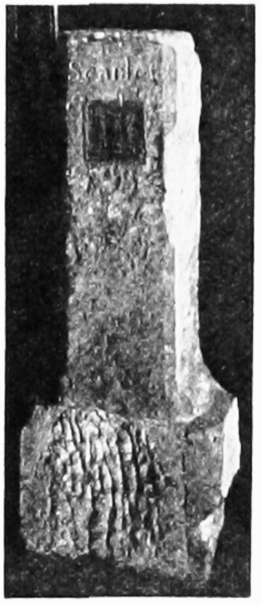
Ancient stone shooting mark, inscribed "Scarlet," preserved at the Honourable Artillery Company's Headquarters.
One notable incident is connected with the fields. On 22nd September, 1598, Ben Jonson and Gabriel Spencer fought a duel in Hoxton Fields, (fn. 102) with the result that the latter received a mortal wound and died instantly. Jonson was indicted for manslaughter and was found guilty, but escaped the capital penalty by pleading benefit of clergy, and being branded by the letter T. (fn. 103)
Those fields, which are marked "Harvey Esq. L." in Chassereau's Map, formerly belonged, as has been shown, to the prebendal manor of Eald Street. Certain of the commonfields of Hoxton were, however, included in the prebendal manor of Wenlock's Barn. This was the case with the two fields marked "Watson L" in Chassereau's Map, and the building shown on their northern boundary apparently was the manor house. (fn. 104) The field next eastward, marked "Ashley Esq., L," of 16 acres, is to be identified with the "close of pasture land commonly called . . Hogsdon Shott or Hogsdon Upper Shott," said to contain 18 acres, included among those portions of the Pitfield property which had not formed part of the original purchase by Sir Charles. (fn. 105) It had in fact been acquired (before 1703) by Ralph Harwood from James Grace, (fn. 106) and is to be identified with the 14 acres in the common field of Hoxton purchased by Arthur Hollingworth from Sir Edward Marow. It was also, therefore, part of the manor of Wenlock's Barn. It is doubtful whether the same can be said of the triangular field lying across the "pathway to the Rosemary Branch." The portion of it marked "Ashley L" represents the acre and three roods lying in the common fields of Hoxton in a shott "commonly called Hoxton Shott." This was also a part of the Pitfield property, (fn. 107) and can be traced back to 1648, when it was in the possession of Hunt Grace, son of James Grace. There is no proof, however, that it was among the property acquired by the latter from Sir Edward Marow. The "Ingram" portion of the field, which the plan of Wenlock's Barn (fn. 108) shows to have been the easternmost, was evidently the acre and a rood called "the Sewer Acre," which Ingram purchased, with other property, from John and Roberta Swynfou and which can be traced back to 1556. (fn. 109) In 1601 it was described as bounded east by land formerly of Samuel Marow (i.e., the field sold by Grace to Harwood, mentioned above), west by land formerly of Million, and south by the "Fludditch." The Lee portion of this field apparently corresponds with that of Million mentioned above. Sir John Lee (d. 1673) is stated (fn. 110) to have owned 2¾ acres of meadow or pasture ground lying in a certain field called "Hogsden Shott," intermixed with other lands of one Hunt Grace and others, but there is no information as to how he came by it.
The field of six acres marked "Ashley Esq." on Chassereau's Map, lying west of Aske's Hospital and Charles Square is referred to in the indenture of 1728 dealing with Pitfield property other than that originally purchased by Sir Chas. Pitfield, as six acres in Gravel Pit Close "near to the conduit head." The eastern strip of it, about 72 feet wide, was left by Sir Charles Pitfield in 1680 to the parishioners of Shoreditch (but has since been lost) under the description of "all that acre of land lyeing in the Laysterne field . . . which I lately ditched out and fenced, being heretofore in two halfe acres (called Pitts and Brentha)." Mention of these is found more than 200 years earlier. Joan Vince (circ. 1463) mentions that her late husband Robert had purchased inter alia "a rode of medowe and a pece of pasture called the Pyttes," (fn. 111) and on 8th December, 1464, John Roket and Edith his wife, daughter of Robert Vynce, sold to John Sharp, together with other property, "the lands called Pyttes and a rood of meadow called Brenthawe." (fn. 112) Both are said to abut on "le Oldestrete," towards the south.
On 9th May, 1663, Thomas Tirrey sold (fn. 113) to William Dashwood "all those foure acres of common or pasture ground lying in the common feild in the parish of St. Leonard, Shoreditch, abutting upon the footeway leading from London to Islington on the west end." This property was purchased from Dashwood by Jane Underwood, who on 15th March, 1663–4, transferred it to the parish of St. Botolph, Bishopsgate, for the performance of the charitable provisions in her late husband's will. In or shortly after 1672, six almshouses were erected on a portion of the ground, three of which were appropriated to the poor of St. Botolph, Bishopsgate, and three to those of St. Botolph, Aldgate, under the provisions of Lady Lumley's charity. (fn. 114) An illustration of the almshouses is given in Wilkinson's Londina Illustrata, II., facing p. 101. They were taken down and rebuilt in 1822 and finally pulled down about 1898. On another part of the ground was erected the "Shepherd and Shepherdess," afterwards the Eagle tavern. The ground lies at the south-eastern end of Shepherdess Walk extending to the backs of the premises in Westmoreland Place.
Two other strips of land in the neighbourhood, marked "St. Luke Cripplegate Poor" and "St. Luke Poor" on Chassereau's Map were given by William Bleyton in 1585 to the parish of St. Giles, Cripplegate. They are described as an acre and a half of pasture ground in the common fields belonging to "Hogsdon," and four acres (afterwards spoken of as three acres) of land lying near Hoxton Field. (fn. 115) The whole of the property was in 1782 leased to the parish of St. Luke, who built a workhouse on the western strip and sub-leased the eastern strip to "one Pitt," who erected Chatham Gardens (now Chatham Avenue).
At the end of the 18th century building had hardly begun on Hoxton Fields. In addition to Chatham Gardens, and a few houses on the Bishopsgate estate, the only buildings, save a few scattered in the neighbourhood of the present Bevenden Street, were at the south-west end of East Road and on the northern portion of the Laysterne Field (Craven Street, Baches Street and the north side of Brunswick Place).