Survey of London: Volume 21, the Parish of St Pancras Part 3: Tottenham Court Road and Neighbourhood. Originally published by London County Council, London, 1949.
This free content was digitised by double rekeying. All rights reserved.
'Tottenham Court Road (east side)', in Survey of London: Volume 21, the Parish of St Pancras Part 3: Tottenham Court Road and Neighbourhood, ed. J R Howard Roberts, Walter H Godfrey (London, 1949), British History Online https://www.british-history.ac.uk/survey-london/vol21/pt3/pp75-76 [accessed 30 April 2025].
'Tottenham Court Road (east side)', in Survey of London: Volume 21, the Parish of St Pancras Part 3: Tottenham Court Road and Neighbourhood. Edited by J R Howard Roberts, Walter H Godfrey (London, 1949), British History Online, accessed April 30, 2025, https://www.british-history.ac.uk/survey-london/vol21/pt3/pp75-76.
"Tottenham Court Road (east side)". Survey of London: Volume 21, the Parish of St Pancras Part 3: Tottenham Court Road and Neighbourhood. Ed. J R Howard Roberts, Walter H Godfrey (London, 1949), British History Online. Web. 30 April 2025. https://www.british-history.ac.uk/survey-london/vol21/pt3/pp75-76.
LIX—TOTTENHAM COURT ROAD (East Side)
The parish boundary between St. Pancras and St. Giles which follows Tottenham Court Road from south to north now turns east at Francis Street but formerly passed farther south through No. 196, the property of Messrs. Heal & Sons (see below). North of this point, the east side of Tottenham Court Road falls therefore within the parish of St. Pancras. The sites fronting the road in this section formed part of four separate properties: (a) the southernmost, Cantlowes Close, on which Torrington Place is built; (b) a six-acre field belonging to the Southampton estate—a long strip, the southern limit of which ran just north of Torrington Place and the northern through Pancras Street; (c) Bromfield, later known as Brickfields, the devolution of which is described at length in Part 2 of the Survey of St. Pancras (pp. 16–18), extending just north of Grafton Way; and (d) Pond Close, part of the grounds of Tottenhall Manor House (see p. 121), cut off by the Euston Road.
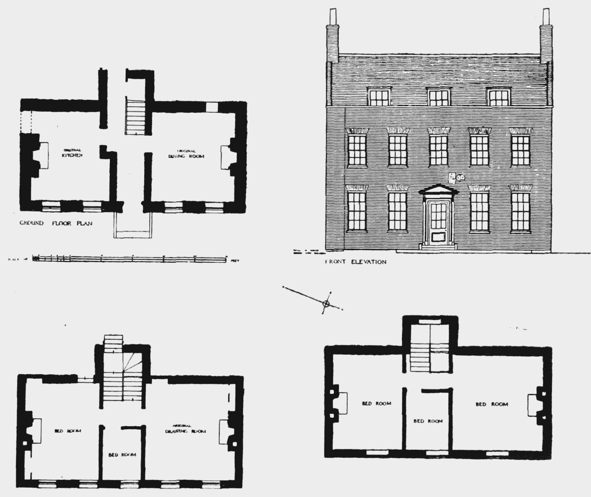
Farmhouse at rear of 196 Tottenham Court Road
The history of Cantlowes Close has already been given in the Survey (St. Pancras, Pt. 2, p. 19) and the farmhouse at the rear of No. 196 Tottenham Court Road, which stood in both parishes and which was demolished about 1917, has been described and illustrated (St. Giles-in-the-Fields, Pt. 2, p. 188 and Plate 107). A ground plan of the building, site plans and further photographs appear in an article in Transactions of the London and Middlesex Archaeological Society, New Ser., Vol. III, pp. 28–33, by Sir Ambrose Heal, who has kindly lent the plans for reproduction (page 75).
It may be recalled here that the farmhouse was known as Capper's Farm from Christopher Capper who was farming the surrounding property as early as 1693. His widow died in 1739, and his daughters, Esther Capper, and Mary Booth were in occupation until 1768. His son was a lecturer at St. George's, Bloomsbury. The Cappers occupied Brickfields and pasture land adjoining it to the east during the first half of the 18th-century. (fn. n1) In his wife's obituary notice in the London Daily Post of 10th July, 1739, Christopher Capper was described as "a great Cow keeper." Brickfields had passed to Hans Winthrop Mortimer of Caldwell (Derby) by 1768 and Mortimer's Market, on the western portion, was in process of building in 1795. (fn. 73) The houses shown on Plate 27 were part of the market which occupied the centre of the island now bounded by University Street on the north, Pancras Street on the south, and Tottenham Court Road and Hunter Street west and east respectively. The eastern portion of the Mortimer estate (Brickfields) was occupied by the northern part of Gower Street and provided the site for University College.
The frontage to Tottenham Court Road was built up in the early years of the 19th-century and the houses are recorded by Tallis in the drawings reproduced here.
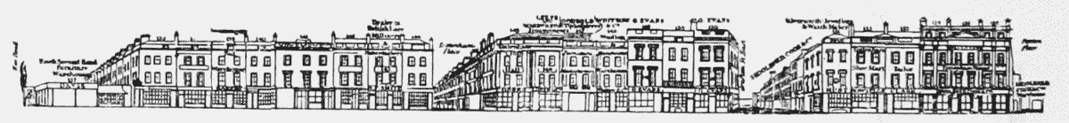
Tottenham Court Road (East side), reproduced from Tallis's Views of London
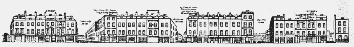
Tottenham Court Road (East side), reproduced from Tallis's Views of London
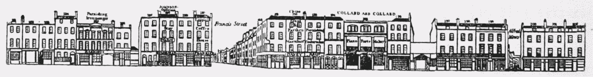
Tottenham Court Road (East side), reproduced from Tallis's Views of London