Survey of London: Volume 26, Lambeth: Southern Area. Originally published by London County Council, London, 1956.
This free content was digitised by double rekeying. All rights reserved.
'General introduction', in Survey of London: Volume 26, Lambeth: Southern Area, (London, 1956) pp. 1-17. British History Online https://www.british-history.ac.uk/survey-london/vol26/pp1-17 [accessed 19 April 2024]
In this section
General Introduction
The Manorial Background
The ancient parish of Lambeth was nearly six miles long from north to south, while its average width from east to west was only about one mile. It stretched from the River Thames opposite the Temple gardens to the wooded heights bordering the great parish of Croydon. The earliest development in the parish took place to the north of Kennington Lane, and this area has already been described in volume XXIII of the Survey of London. The present volume describes the remainder of the parish, and includes part of Kennington and Vauxhall, as well as South Lambeth, Stockwell, Brixton, Denmark Hill, Herne Hill, Tulse Hill and West Norwood.
The expansion of London south of the Thames did not begin in earnest until the second half of the 18th century, and in Lambeth south of Kennington Common (now Park) there were few buildings before about 1800. In 1801 the population of the whole ancient parish was 27,985; in 1901 that of the Metropolitan Borough of Lambeth, whose boundaries differed form those of the ancient parish only in relatively small degree, was 301,895. (fn. 1) The development of the area under review was therefore largely concentrated within the span of a single century. Owing to the great length of the parish from north to south many of the rapidly changing phases of London's expansion are illustrated in Lambeth. Although few of its buildings are of great architectural distinction, the area does contain many churches, schools, institutions and domestic buildings which are of considerable interest to the student of 19th century architecture.
Geographically Lambeth falls into three parts: the northern area close to the river (most of which has already been dealt with in volume XXIII), a flat central plain comprising South Lambeth, Stockwell and part of Brixton, and the rising ground to the south, where Herne Hill, Brixton Hill, Tulse Hill, Knight's Hill and Gipsy Hill provide a pleasant contrast with the level expanse of the Thames basin. Down the length of the parish ran the River Effra (also known in its northern reaches as Vauxhall Creek) whose tributaries rose in Norwood and joined together to flow beside Croxted Road and Brixton Road, part of which was sometimes called the Washway, as far as Kennington. There it divided to the west of the Oval and ran in two separate streams into the Thames.
The land upon which the buildings of modern Lambeth stand formerly comprised ten manors, whose Lords, acting either individually or through the manorial courts, could even in the 19th century play an important part in controlling the tenure and use of the land. The manors are therefore the natural starting-point for a survey of the fabric of the area. The three most important manors were those of Lambeth, Kennington and Vauxhall. Except during the Commonwealth period, none of these has been in private hands since the early Middle Ages, and their long unbroken continuity of administration has probably been the cause of the safe preservation of the records from which so much of the information contained in this volume has been drawn.
Of these three manors, that of Lambeth was much the largest in area. It stretched from the timber-yards bordering the Thames in the north to the Vicar's Oak at Sydenham in the south, and contained 1,474 acres. (fn. 2) The manor became the property of the Archbishop of Canterbury in 1197, (fn. 3) and it remained (except during the Commonwealth) in the hands of his successors until its administration was taken over by the Ecclesiastical (now Church) Commissioners in 1862. In 1806 an Inclosure Act (fn. 4) was obtained, and the award of 1810 provided inter alia for the inclosure of Rush Common and Norwood Common.
Kennington Manor consisted of a large area on either side of Kennington Lane, and several detached portions to the north in Lambeth Marsh. The latter and all of the main parcel on the north side of Kennington Lane have already been described in volume XXIII of the Survey of London; the rest of the southern piece falls within the area covered by the present volume. In 1337 Edward III granted the Manors of Kennington and Vauxhall to Edward, Earl of Chester and Duke of Cornwall, commonly known as the Black Prince, to be held by him and his heirs, eldest sons of the Kings of England and Dukes of Cornwall; the grant provided that if any such duke should die without a son to whom the duchy might descend, the Manors should revert to the King until a son should be born who was heir-apparent to the realm. (fn. 5) Except during the Commonwealth, this grant has remained operative ever since, and the Manor of Kennington is administered with other estates belonging to the Duchy of Cornwall.
Until the close of the 13th century the area now known as Vauxhall seems to have been part of a large manor called South Lambeth Manor. In 1293 the latter and the Manor of “la Sale Faukes” came into the hands of Edward I. (fn. 6) No further mention has been found of South Lambeth Manor, which seems to have been divided into two parts known as Vauxhall and Stockwell Manors. In 1337 Edward III granted the former to the Black Prince, who in 1362 granted it to the Prior and Convent of Christ Church, Canterbury. (fn. 7) After the Dissolution Vauxhall Manor was granted to the Dean and Chapter of Canterbury; its administration was taken over by the Ecclesiastical Commissioners in 1862. (fn. 8) The core of the manor lay between Kennington and Stockwell in the areas loosely known as Vauxhall and South Lambeth, but there were large pieces of copyhold and common land in Streatham and Mitcham.
The other part of South Lambeth Manor, Stockwell, seems to have acquired manorial status at the end of the 13th century, but a connection with Vauxhall Manor was retained until as late as the early 19th century. (fn. 9) Since the early 14th century Stockwell Manor has been in private hands except for a short period in the 16th century when it was held by the Crown. (fn. 10) The manor lay in Stockwell and Brixton, and stretched south along the west side of Brixton Hill.
There were also six lesser manors, three of which appear to have had tenuous connections with Lambeth Manor. One-third of the Manor of Milkwell, which lay in Lambeth and Camberwell, was subject to a quit-rent of 6s. 8d. per annum payable to Lambeth Manor; (fn. 11) the small Manor of Heathrow or Knight's in Brixton was subject to a similar rent of 12d., (fn. 12) while Levehurst Manor on the borders of Lambeth and Streatham owed 10s. (fn. 13) A fourth, Lambeth Wick Manor, was from the end of the 12th century owned by the Archbishops of Canterbury, who between 1480 and the beginning of the 19th century leased it for short terms. (fn. 14) Only two of these so-called manors in the area under review seem to have had no connection with Lambeth Manor—Bodley, Upgrove and Scarlettes, which occupied the area now called Tulse Hill and belonged to the Hospital of St. Thomas the Martyr in Southwark from the 14th century until the Dissolution; (fn. 15) and Leigham Court, the bulk of which lay in Streatham and was alleged to have been part of the ancient demesne of the Crown. (fn. 16)
Thus of the ten manors in Lambeth, four (Lambeth, Lambeth Wick, Kennington and Vauxhall) were held by Lords acting as custodians for their successors, and managed by courts which were still active enough to exercise a very important influence over 18th and 19th century building development. In manors of this type Acts of Parliament authorizing the Lord to adapt the ancient customs to the needs of developers were frequently obtained. In Stockwell and Leigham Court Manors it is doubtful if courts were held as late as the 19th century; in the Manors of Milkwell, Levehurst, Heathrow and Bodley, Upgrove and Scarlettes, courts may never have been held at any date, the Lords (or more accurately owners) either farming them themselves or leasing them.
But despite the wide variety of meaning which the term “manor” could imply, particularly in the 18th and 19th centuries, the manors still exercised an exceedingly important influence on the development of their areas. In carefully managed manors like Kennington or Lambeth the length of the leases or the licences to demise granted by the Lord or the scale of fines payable upon the admittance of a new copyholder, affected the type of buildings erected; while in the case of a small manor where no courts were held the enterprise or indifference of the owner, his financial position and even his testamentary dispositions could all affect the character of development.
Apart from the Turnpike Trusts the normal machinery of public administration played little part in the development of Lambeth or many other parts of London until the second half of the 19th century. The Open Vestry of Lambeth obtained a Local Act in 1810, (fn. 17) and it adopted Sturges Bourne's Act for poor law purposes between 1819 and 1827. (fn. 18) In the first half of the century the lighting of the parish was managed by nine separate local Trusts, while the road from Herne Hill to the Half Moon at Dulwich was lit by private subscription of the inhabitants. (fn. 19) In the second half of the 19th century, when the Metropolitan Board of Works and the Vestry began to control building development, much of the new character of the district had already been determined by other factors to which attention must now be turned.
Roads and Railways
In South London during the first half of the 19th century the course of the parish and Turnpike roads was often the deciding factor in determining where and when new houses should be built; in the second half of the century this role was to a great extent taken over by the railways.
In the area under review the two main arteries of communication were the road now known as Kennington Park Road and Clapham Road, and the road now known as Brixton Road and Brixton Hill (fig. 1). The former was part of Stane Street, which ran from the East Gate of Chichester through Pulborough, Dorking and Tooting to London. The date of its construction is uncertain, but it is likely that it was in use in A.D. 70. No trace of the Roman surface has been found in Lambeth, but there can be little doubt that it ran along Kennington Park Road and Clapham Road. (fn. 20)
Brixton Road and Brixton Hill may also have been part of a Roman road. Recent research has shown that a Roman road ran from Brighton or Portslade through the Weald to the Caterham Valley gap, and then on to Croydon and Streatham, whence it either went straight on to Stane Street, or followed the modern Brixton Hill and Brixton Road to form a junction at or near Kennington Park. (fn. 21) Traces of this road have been found in Sussex and Surrey, and in their History of Surrey (1814) Manning and Bray thought that “it took its course by Old Croydon and the West side of Broad Green, where it is still visible” (fn. 22) From Croydon it probably continued up London Road to Streatham, a name suggesting the existence of a Roman road. (fn. 23) From there its course can only be conjectured, but Brixton Hill, which was formerly known as Brixton Causeway, and Brixton Road may well have been the northern continuation of this road.
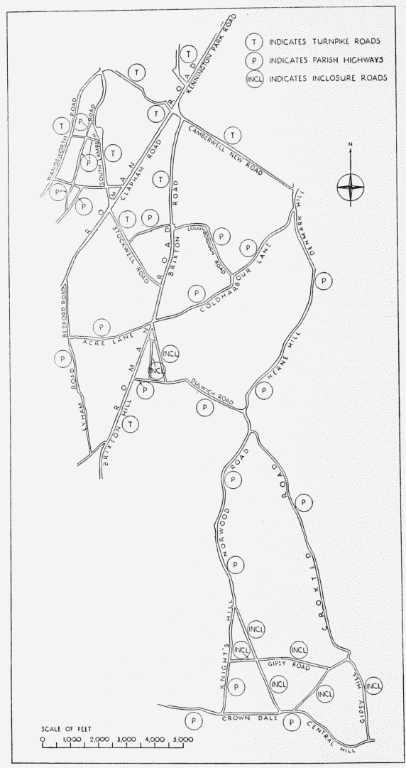
Principal roads in southern Lambeth. Wandsworth, South Lambeth, Clapham, Stockwell, Kennington Park and Brixton Roads and Brixton Hill were all parish highways before being placed under the authority of Turnpike Trustees
In 1717 an Act of Parliament (fn. 24) set up Turnpike Trustees for the roads from the Stones End in Blackman Street, Southwark, to East Grinstead, Sutton and Kingston. The East Grinstead road comprised what is now Kennington Park Road, Brixton Road and Brixton Hill, and ran on through Streatham and Croydon; the Sutton and Kingston roads comprised Clapham Road and Wandsworth Road respectively. The Trustees were also responsible for a branch road from Vauxhall to Brixton, now South Lambeth Road and Stockwell Road. (fn. 25) In 1751 the Trustees were authorized to make a new road (now Kennington Road) joining Kennington Common with the south end of the road made by the Commissioners for building Westminster Bridge. (fn. 26) In 1786 these Trustees and the Trustees for the Southwark to Highgate (Sussex) roads became known as the Trustees of the Surrey New Roads. (fn. 27) Finally the system of Turnpike roads in the southern part of Lambeth was rounded off in 1818 by the formation of Harleyford Road, Harleyford Street and Camberwell New Road, (fn. 28) which were intended as approach roads to Vauxhall Bridge, opened in 1816.
Besides the great Turnpike roads there were also a number of ancient and often winding country lanes, which were repaired by the parish Surveyors of the Highways. Roque's Map of the Environs of London (1741—5) shows, amongst others, Coldharbour Lane (called Camberwell Lane) connecting Camberwell and Brixton, while Acre Lane (whose western extremity is now called Clapham Park Road) led on to Clapham. “The Back Road”D; ran along what is now Bedford Road and Lyham Road, forming a short-cut between Clapham and the top of Brixton Hill. Water Lane has been straightened at the west end and is now called Brixton Water Lane and Dulwich Road. Camberwell and Dulwich were connected by what are now Denmark Hill and Herne Hill. To the south ran “Crocksed” or “Crocksted” Lane, which eventually split into a number of tracks in Norwood, and “Night's Hill Lane” which followed the winding course of what is now Norwood Road and Knight's Hill. The only road running east and west in the south part of the parish was provided by what are now Streatham Common North, Crown Lane, Crown Dale, Central Hill and Westow Hill. Here and there, at Brixton or along the west side of Norwood Common, groups of cottages or an occasional farm stood beside these old roads. Often there was a tavern, but of this humble and rural type of building there is now no trace save the memory preserved by the name of an old inn, such as the Horns at Kennington.
Apart from the Turnpike roads and the ancient parish highways, almost all the roads of modern Lambeth were made in the 19th century. The first important extension of the system was made in 1810 when the Lambeth Manor Inclosure Commissioners provided for a number of new roads in the southern part of the parish. The purpose of most of these roads was to supply access to the new inclosures on Rush Common and Norwood Common. They included what are now Effra Road and St. Matthew's Road, Brixton, and Norwood High Street, Elder Road, Chapel Road, Gipsy Road, Salter's Hill, and Gipsy Hill. The occupiers of land and houses on the old Rush Common and Norwood Common were made responsible for the maintenance of these new roads; they were to form themselves into two distinct committees, appoint officials and meet the cost of the necessary work by levying a rate upon themselves not exceeding one shilling in the pound, and by collecting tolls from the users of the roads. In 1823 all these roads were taken over by the parish Surveyors of the Highways. (fn. 29)
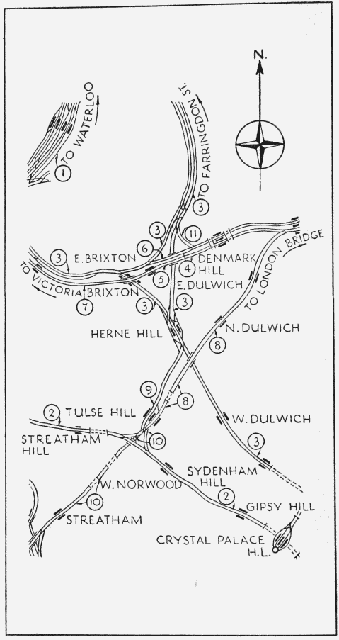
Diagram of Railway Development (not to scale)
1. London and South Western 1848
2. West End of London and Crystal Palace
3. London Chatham and Dover 1862–3
4. London Brighton and South Coast 1866
5. London Brighton and South Coast 1866
6. London Chatham and Dover 1866
7. London Chatham and Dover 1867
8. London Brighton and South Coast 1868
9. London Chatham and Dover 1869
10. London Brighton and South Coast 1871
11. Crystal Palace and South London 1872
Almost all the other roads of modern Lambeth were in the first place estate roads whose original purpose was to facilitate the development of the area through which they ran. After the death of Lord Thurlow in 1806, his Trustees obtained an Act of Parliament (fn. 30) permitting them, inter alia, to grant long leases on parts of his large estates in Lambeth and Streatham, and to build certain roads which included those now known as Palace Road and Canterbury Grove. A few years later Dr. Edwards, the owner of Tulse Hill Farm, built the roads now known as Tulse Hill and Upper Tulse Hill. Very gradually these estate roads provided communication across the fields which had been left untouched by the early ribbon-development along the old highways; ultimately the parish took them over, and the complicated street–system of modern Lambeth emerged. (fn. 31)
In the second half of the 19th century the railways played the decisive part in determining the type of development which overwhelmingly preponderates in the area today. In the first half of the century large houses, often with a coach-house attached, were built along the Turnpike and parish roads; many of these houses can still be seen in Brixton and Clapham Roads. This type of development continued along some of the earlier estate roads like Tulse Hill and Upper Tulse Hill. But the railways enabled a less prosperous and far more numerous section of the population to live in much greater comfort in the suburbs and travel to and from their work.
The first railway in the southern part of Lambeth (apart from a short piece of the Waterloo extension of the London and South Western Railway which was authorized in 1845, see fig. 2, no. 1) was the West End of London and Crystal Palace Railway, which was authorized in 1853 and opened in 1856 (fn. 32) (fig. 2, no. 2). It ran from Battersea through Clapham, West Norwood and Gipsy Hill to the Crystal Palace, and continued on to a junction with the London, Brighton and South Coast Railway north of Norwood Junction. Next, and far more important, came the London, Chatham and Dover Railway, a late-comer, which started in the provinces as the East Kent Railway and shouldered its way into London through the territory of the South Eastern and the London, Brighton and South Coast Railways. In 1860 the London, Chatham and Dover Company's trains first reached Victoria by using lines owned by the Mid-Kent, West End of London and Crystal Palace, and Victoria Station and Pimlico Railways. (fn. 33) But in the same year the famous “Metropolitan Extensions” Act (fn. 34) granted the London, Chatham and Dover Company greatly improved access to London. From Penge Junction a line ran through Herne Hill to Farringdon Street, with a junction at Smithfield with the Metropolitan; another line branched off from Herne Hill to the Victoria Station and Pimlico line at Battersea; finally a spur from Brixton to Loughborough Junction connected these two arms and completed a triangle of lines which formed the foundation of the complicated maze of railways in the area (fig. 2, no. 3).
By 1863 all the lines authorized by the Metropolitan Extensions Act had been opened. (fn. 35) In the same year a Select Committee of the House of Lords published a report on Metropolitan Railway Communication. The opening of the Metropolitan Railway between Edgware Road and Farringdon Street had just inaugurated a new era in London transport, and the report therefore stated that it was not desirable to bring any more main-line termini any further into London, that in the construction of any new railways in London, subways, tunnels or covered ways were to be preferred, and that girdle railways were needed to connect the existing main-line termini. (fn. 36)
With this report in mind, Parliament rejected several schemes for more lines in Lambeth. A most complicated arrangement was eventually approved in the sessions of 1863 and 1864, whereby Victoria and London Bridge were connected by direct lines above ground, the cost and the marshy character of part of the area presumably making covered ways impracticable. The Lambeth portions of these lines were built conjointly by the London, Brighton and South Coast and the London, Chatham and Dover Companies (fn. 37) (fig. 2, nos. 4–7). All these lines were opened by 1867, though not without mishap, for in 1864 nineteen newly-completed arches at Brixton collapsed when the centering was removed. (fn. 38) They also involved the construction of two high bridges over the Herne Hill to Brixton and Herne Hill to Loughborough Junction arms of the Metropolitan Extension, the latter having only been completed in 1863. In 1872 another spur, built by the Crystal Palace and South London Junction Railway and involving the erection of three iron bridges and the demolition of a number of houses in Flaxman Road, joined Loughborough Junction with the line to Peckham (fn. 39) (fig. 2, no. 11).
Apart from the widening of existing tracks, only two more lines were built in the southern part of Lambeth. The London, Chatham and Dover Company built a line from Herne Hill to Tulse Hill which was opened in 1869 and used by the London and South Western Company for a service between Wimbledon and Ludgate Hill (fn. 40) (fig. 2, no. 9). The London, Brighton and South Coast Company built a line from Peckham to Streatham, with spurs to the old West End of London and Crystal Palace Railway; the northern part of this line was opened in 1868, and the remainder in 1871 (fn. 41) (fig. 2, nos. 8 and 10).
The 1860s saw the railways take their modern course through Lambeth; horse-drawn trams soon provided another means of travel. In 1861 G. F. Train opened a line from the south end of Westminster Bridge to Kennington Park, and within a few months his trams were carrying over half a million passengers a month. Legal difficulties ensued, however, and the line was closed soon afterwards. (fn. 42) By 1870, however, trams were running down Westminster Bridge Road and Kennington Road to the junction of Brixton Hill and Brixton Water Lane; another route ran down Clapham Road. Within twenty years most of the main roads of the area were served by trams, (fn. 43) and this tremendous expansion was matched by the development of buses, whose numbers nearly trebled in the whole of London between 1871 and 1898. (fn. 44)
The last stage in the growth of suburban transport in Lambeth was reached with the opening of the City and South London Railway in 1890. This was the first tube railway in London, and ran from King William Street to Stockwell. It was electrically operated, with twin tunnels never less than forty-five feet below ground level. As usual with a new form of suburban transport, the line attracted a constantly increasing number of passengers, and the King William Street terminus was incorporated into the Bank Station; at the south end, the line was extended to Clapham Common. In 1922 the tunnels were enlarged and the line was subsequently absorbed into the Northern tube line, which ultimately reached out above ground to Morden. (fn. 45)
With these new means of travel the development of Lambeth, and of many other parts of London, was jolted on to a new course in the second half of the 19th century, and undistinguished speculation provided thousands of homes for families which could never have afforded the more spacious suburban houses of the pre-railway age.
The Pattern of Development
Apart from a thin line of buildings along the riverside there was little development in Lambeth until the middle of the 18th century. The opening of Westminster Bridge in 1750, the authorization of Kennington Road in 1751, and the building of Blackfriars Bridge and its approach roads between 1760 and 1769 provided easy access to Kennington from Westminster and the City. In 1776 William Clayton, the lessee of the Kennington Manor demesnes, obtained an Act of Parliament (fn. 46) enabling him to grant building leases, and in 1791 the Council of the Duchy of Cornwall decided that copyholders might be granted licences to demise their property for 99 years. (fn. 47) In the eastern part of the Manor houses soon began to spring up in considerable numbers. West of Kennington Road development did not make much progress until the end of the 18th century; the area remained relatively inaccessible from London and Westminster until the opening of Vauxhall Bridge in 1816, and the building of Harleyford Road and Camberwell New Road in 1818.
Vauxhall and South Lambeth were also too remote to be much affected by the opening of Westminster and Blackfriars Bridges and their approach roads. The existing roads were considered adequate, and no new ones were authorized until the early 19th century. Moreover the different types of land tenure which persisted for centuries in the Manor of Vauxhall, the small fields and the impossibility of obtaining enough contiguous land to make development worth while, all hindered the making of side roads and the building of houses. With London so near, market gardening and dairy farming were very profitable, so that little housing development took place before the opening of Vauxhall Bridge in 1816. The opening in 1848 of the London and South Western Railway Company's extension from Nine Elms to Waterloo was largely responsible for the industrialization of much of the neighbourhood. Many of the surviving buildings of architectural interest were erected in the brief period between 1816 and 1848.
South of Kennington Common (now Park) there was little building in Lambeth before the 19th century. A large proportion of this area formed part of the Archbishop's Manor of Lambeth, whose development was greatly influenced by a number of Acts of Parliament. The Inclosure Act of 1806 (fn. 4) resulted in the inclosure of Rush Common and Norwood Common and the formation of a number of roads. In the following year the Archbishop was authorized to grant 99-year leases in LambethWick Manor and parts of Lambeth Manor. (fn. 48) In 1824 this power was extended to a large area in Norwood. (fn. 49) More important still was the statutory authority obtained in 1825 for the Archbishop to grant his copyhold tenants licences to demise their property for 99 years. (fn. 50)
The application of these powers produced a spate of building, particularly in the Brixton area, which was affected by the opening of Vauxhall Bridge. Most of this early development took the form of undistinguished houses standing alongside the existing main roads like Brixton Road and Camberwell New Road. By the middle of the century ribbon development had stretched long fingers into most of the accessible parts of the Manor. Only in the northerly parts had the more laborious and expensive process of making side roads begun; Lorn Road, for instance, was formed about 1840, and Loughborough Park, which was in the Manor of Lambeth Wick, between 1844 and 1857.
Simultaneously another type of development was proceeding in several of the smaller manors where courts had never been held or had not been held for many years. Here there were no traditional manorial customs which could only be overridden by statutory authority, so that unless the private circumstances of the owner were unusual, no special Act of Parliament was necessary for development. In 1783, Samuel Sanders, a wealthy timber merchant, purchased that part of the Manor of Milkwell which occupied the areas now known as Denmark Hill and Herne Hill, (fn. 51) and shortly afterwards he began to grant long leases of large plots with frontages to the existing road. By 1843 an almost continuous line of houses stretched along the west side of the roads now known as Denmark Hill and Herne Hill. In the neighbouring districts of Tulse Hill and Brockwell Park, which formed part of the Manor of Bodley, Upgrove and Scarlettes, Dr. Thomas Edwards built two roads, now Tulse Hill and Upper Tulse Hill, in 1820–1, (fn. 52) and also began to grant long leases; while his wealthy neighbour John Blades, after toying with similar schemes, only lived long enough to build two large and a pair of semi-detached houses.
This type of development differed fundamentally from that which predominated in Kennington and Vauxhall. The houses were nearly all detached or semi-detached, and their relatively large front and back gardens provided a quasi-rural atmosphere which is completely absent from the terrace houses of 18th and early 19th century London streets. Perhaps because the ground landlords had a more personal interest in their property, better results were achieved at Denmark Hill, Herne Hill and Tulse Hill than by the haphazard development along Brixton Road.
Many of the inhabitants of these new residential areas were successful London business men. Two of the first inhabitants of houses built at Denmark Hill in the 1780s have been identified as a linen-draper from Southwark and a merchant from Budge Row, Cannon Street. The history of John Ruskin’s family illustrates the first prosperous phase of the 19th century migration to the new suburbs. Until 1823 John Ruskin’s father, a winemerchant, lived in a terrace house in Hunter Street near Brunswick Square; his office was in Billiter Street in the City, and every summer the family moved for a few weeks to lodgings in Hampstead or Dulwich. (fn. 53) In 1823 he took a three-storey semi-detached house (with garrets and basement) at Herne Hill, whose previous occupant had been a linendraper in Cheapside. (fn. 54) He continued to attend his office daily, returning to dine at Herne Hill at half-past four. (fn. 55) Of their neighbours the family saw almost nothing. “They were for the most part well-to-do London tradesmen of the better class” and often had “They were cortege of footmen and glitter of plate, extensive pleasure grounds, costly hot-houses, and carriages driven by coachmen in wigs”. (fn. 56) In 1842 his continued prosperity enabled Ruskin's father to take a larger and detached house at Denmark Hill where he lived until his death in 1864. (fn. 57) John Ruskin's loving descriptions of Herne Hill in his childhood go far to explain the attractions of suburban life. “The view from the ridge on both sides was, before railroads came, entirely lovely: westward at evening, almost sublime, over softly wreathing distances of domestic wood;—Thames herself not visible, nor any fields except immediately beneath; but the tops of twenty square miles of politely inhabited groves. On the other side, east and south, the Norwood hills, partly rough with furze, partly wooded with birch and oak, partly in pure green bramble copse, and rather steep pasture, rose with the promise of all the rustic loveliness of Surrey and Kent in them, and with so much of space and height in their sweep, as gave them some fellowship with hills of true hill-districts.” (fn. 58)
Development similar to that on Denmark Hill, Herne Hill and Tulse Hill also took place in the small Manors of Heathrow and Levehurst. But in each of these cases the process was regulated by Trustees acting under Chancery supervision and in accordance with a private Act of Parliament. Robert Stone, the owner of Heathrow Manor, most of which lay on the east side of Effra Road and the north-east side of Dulwich Road, died in 1820 leaving so many debts that the whole estate was sold in the course of the next thirty-five years. (fn. 59) Levehurst Manor formed part of Lord Thurlow's very extensive estates. After his death in 1806 his Trustees obtained an Act (fn. 30) enabling them to develop the property, and Levehurst was sold in 1825. Here an attempt was made to lay out a large circus in a fine position on top of a steep hill, but the scheme petered out and Royal Circus remains as a memorial to an unsuccessful speculation. (fn. 60)
With the coming of railways, trams and buses, the pattern of suburban development changed. Except in certain parts of Norwood (Thurlow Park Road, Palace Road and near the Crystal Palace) where the undulating ground provided attractive sites, few large detached houses were built in Lambeth after about 1860, and the area became the scene of widespread routine speculative building. This process produced architecturally undistinguished results, but a few general points concerning its workings may be noted.
After an Act of 1841 had authorized Lords of Manors to enfranchise copyhold land upon receipt of a lump sum payment from the tenant, (fn. 61) the ancient manorial customs seldom proved obstacles to building. Although the Acts regulating building in London had applied to Lambeth since 1707, (fn. 62) there was probably little real supervision until the establishment of the Office of Metropolitan Buildings in 1844. (fn. 63) In 1855 the control of building was taken over by the Metropolitan Board of Works. (fn. 64)
Most of the building in the area was done by small local firms who seldom engaged to build more than ten houses at a time; their yards were usually within a mile of the sites. (fn. 65) There was, however, one firm in Lambeth which at the beginning of the 20th century was large enough to undertake big contracts all over the country. Higgs and Hill Ltd. began as two businesses in north London. At the beginning of the 19th century Thomas Hill, builder, was working in Islington. His grandsons, Rowland and Joseph Hill, married sisters, Matilda and Mary Ann Edmonds, and through a friendship which Mrs. Joseph Hill formed at school with Lettie Higgs, her husband met William Higgs, Lettie's father. (fn. 66) William Higgs had been apprenticed to his uncle, Joshua Higgs, of Davies Street, Berkeley Square, and after saving £50 he started his own business in Bishop's Bridge Road, Paddington, in 1845. Shortly afterwards he moved to Euston Road, and again in 1852 to Palace Road, Lambeth, where he secured many contracts for churches, schools and public buildings. (fn. 67) In 1867 the business was transferred to a large four-acre site in Lawn Lane, Vauxhall, and in 1874 the two firms were amalgamated as Hill, Higgs and Hill. The two Hill brothers came to live at Clapham, but Rowland retired in 1879, when the name of the firm was changed to Higgs and Hill. As well as many buildings in Lambeth (part of Spurgeon's Homes, part of Wyvil Primary School, the north and south blocks of County Hall, and the London Fire Brigade Headquarters on the Albert Embankment) Higgs and Hill obtained contracts for the erection of Peter Robinson's in Oxford Street, the Tate Gallery, the Royal Naval College, Dartmouth, etc. (fn. 66)
Many of the people who occupied the speculators' new houses were clerks, shopkeepers, skilled artisans and the rank and file of the commercial world. Some of them were migrants from the surrounding countryside, attracted to London by the hope of better wages and housing; others may have come from the inner districts of London, many of which had been invaded by the very poor class of people who had lost their homes through the building of railways and the widening of main streets. Throughout the new suburbs people were constantly on the move. “Southwark is moving to Walworth, Walworth to North Brixton and Stockwell, while the servant-keepers of outer South London go to Croydon and other places.” (fn. 68) As early as 1848 commerce was invading a residential area of Kennington, for in that year the occupier of a house in Kennington Park Road wrote to the Duchy of Cornwall to complain of the dust caused by his neighbour, whose trade was “shaker of mats, rugs, carpets, etc.”—“at Breakfast I sometimes get nearly smothered”. (fn. 69) Inconveniences of this kind gradually led to the wealthier inhabitants moving further out of London; in 1871 John Ruskin gave up his house at Denmark Hill, which was later used as a hotel. (fn. 57) The leap-frog of suburban expansion had, in fact, begun in Lambeth long before the completion of the development of the area.
Many suburban householders had little capital, but were able to buy their houses through a building society. In the first half of the century a number of terminating building societies had been formed, which built houses for their members out of the capital accumulated by weekly subscriptions; when all the houses had been built and the advances paid off, the societies dissolved. The activities of these societies were supplemented by those of the land societies, whose original purpose was to buy land for distribution amongst their members, who would thus acquire a Parliamentary vote in counties. By the 1860s this political aim had been largely abandoned in favour of house ownership, while by about the same time many of the terminating building societies had been superseded by permanent societies, which borrowed from one class and lent to another. By 1870 there were 2,000 building societies in England and Wales, with a total membership of 800,000. (fn. 70) In 1874 the movement was regulated by an Act which remained the societies' basic code for many years. (fn. 71)
In the second half of the 19th century there were fourteen societies with names suggesting that Lambeth was the main scene of their activities. Of these the present Lambeth Building Society, found in 1852, is the sole survivor. (fn. 72) It is impossible to assess the extent or distribution of these societies' mortgages, but their work, and that of many other societies outside the parish, in the provision of money for the purchase of small houses made possible the tremendous suburban expansion of this period. Most of their advances were made to middle-class borrowers, and nearly five-sixths of their loans were for amounts of less than £300. (fn. 70)
The land societies do not appear to have bought large estates in Lambeth. A small estate on the north-east side of Dulwich Road was bought by the Westminster Freehold Land Society in 1855; (fn. 73) there were probably others. The area under review was too far from the middle of London for the semi-philanthropic housing bodies to buy land, and the Peabody Trustees' estate at Rosendale Road, where the earliest buildings were erected in 1901, provides the only example of this type of development.
Lambeth does, however, contain an early instance of the work of a land company, many of which were founded in the late 1860s after the constitution of joint stock companies with limited liability. (fn. 70) The purpose of these companies, of which the Artisans', Labourers' and General Dwellings Company, Ltd. was the most important, was to provide houses within the purchasing power of working men. In 1868 a 99-year lease of twenty-four acres was taken on behalf of the Suburban Village and General Dwellings Company. (fn. 74) The land lay beside the recently-opened eastern arm of the Metropolitan Extension of the London, Chatham and Dover Railway Company, and the rapid development of Milkwood Road, its main street, was greatly helped by the cheap fares for workmen which the Railway Company was compelled to provide. (fn. 75) The popularity of these cheap fares was, indeed, a most important factor in the development of working-class suburbs in the latter part of the century. By 1911 workmen's fares accounted for over twenty-five per cent of the entire passenger traffic on the South Eastern and Chatham Company's lines. (fn. 76)
The population of Lambeth reached its peak at the census of 1901, and with the virtual completion of the fabric of the area, later developments do not come within the scope of this volume.
The Fabric
In the area under review, a typical 19th century London suburb, the churches, chapels, schools and public buildings stand out in high relief against the general background of mediocrity created by the domestic buildings. There are, of course, several late Georgian terraces and houses of real merit, but in the main this is a fair generalization.
First among the churches are the four Greek Revival buildings erected between 1819 and 1825, known as the “Waterloo” churches and dedicated to the four evangelists, Matthew, Mark, Luke and John (Plates 2, 3, 4, 5, 6, 7, 8, 9, 10, 11, 12). These resulted from a resolution passed in 1819 by the Lambeth Vestry, (fn. 77) which appointed a committee to negotiate with the Church Building Commissioners for the provision of four churches in the parish, the cost being met by a grant from the Commissioners, by private subscriptions and by a church rate levied until 1850. (fn. 78) By far the finest of these churches is St. Matthew's, Brixton, consecrated in 1824, a noble Doric design by C. F. Porden. St. Mark's, Kennington, consecrated in 1824 and designed by D. R. Roper (also attributed to A. B. Clayton), is a far less satisfactory building, while St. Luke's, Norwood, designed by Francis Bedford and consecrated in 1825, is chiefly remarkable for the superb siting of its elegant portico and steeple. The fourth church, St. John's, Waterloo Road, also designed by Bedford and consecrated in 1824, is described and illustrated in volume XXIII of the Survey of London. The Brixton, Kennington and Norwood churches stand in open churchyards at important road junctions, but the demand for correct orientation prevented those at Brixton and Kennington from being sited for the maximum architectural effect. At Norwood, however, where a clause in the Inclosure Act of 1806 restricted the use of the site and caused the church to be built on a north to south axis, the portico and steeple command the attention they deserve.
The mid-19th century churches show a change in taste together with a decline in architectural quality, sometimes compensated by the part they play in providing a focal centre to a well laid-out residential area. Cases in point are St. Michael's, Stockwell Park Road (1841), an emaciated Gothic building of brick, reflecting the taste and parsimony of the Commissioners at that time (Plate 14a); St. Barnabas', Guildford Road (1850), a nondescript Gothic design in the increasingly popular ragstone; and St. John's, Angell Town (1853), a Gothic church of excellent form but poor detail, designed by Benjamin Ferrey (Plate 16).
Christ Church, Brixton Road (Plate 17), St. Anne's, South Lambeth Road (Plate 13c and d), and St. Matthew's, Denmark Hill (Plate 14b), superseded proprietary chapels, while St. Andrew's, Stockwell Green (Plate 13a and 13b), is actually a once charming late 18th century chapel recast in a sour Romanesque style.
The late Victorian churches are far more impressive. St. John the Divine, Vassall Road (Plates 18, 19), is outstanding, a Gothic masterpiece of G. E. Street, consecrated in 1874 and gutted during the war of 1939–45. All Saints', Rosendale Road (1888–91), is an unfinished but highly dramatic Gothic church by G. H. Fellowes Prynne (Plate 21), who also completed St. Peter's, Leigham Court Road (1870–7, Plate 20). Christ Church, Brixton Road (1898–1902), is an eclectic Byzantine design by that wayward original, Beresford Pite (Plate 17).
The Roman Catholic churches came later than those of the Establishment. First in date and architectural importance is the unfinished church of Corpus Christi, Trent Road (Plates 22, 23), first used in 1887, the torso of a sensitive and highly complex Gothic design by J. F. Bentley. St. Anne's, Kennington Lane (Plate 24), opened in 1903, is a Gothic hall church of noble simplicity, designed by F. A. Walters. Four small churches of no architectural distinction, known as Ellis churches after a generous benefactor, were built in the area during the first decade of this century, probably to the design of F. W. Tasker. They are St. Philip and St. James, Poplar Walk; St. Helen's, Robsart Street (now closed); St. Matthew's, Norwood High Street; and St. Francis of Sales and St. Gertrude, Larkhall Lane.
The earlier chapels of the Nonconformist sects adhere to the precedent of the 18th century preaching-box, but their later churches incline to the style and form of the Establishment's buildings. The earlier style is well represented by Trinity Congregational Church in St. Matthew's Road (Plate 25a), with its pleasant brick front of almost domestic character, but Trinity Presbyterian Church in Clapham Road (Plate 26b), designed in 1862 by Habershon and Pite, commands attention by its pompous Roman portico. The later type is represented by Roupell Park. Methodist Church (Plate 27b), a Gothic ragstone building designed in 1879 by Charles Bell, the steeple of which is a conspicuous landmark in the neighbourhood.
The schools in the area belong to two distinct groups—those sponsored by religious societies, such as the National Society, and those built after 1870 by the London School Board, the buildings of each group clearly reflecting their origin. Befitting their parochial and denominational origin, the church schools are much smaller and architecturally more varied than those of the School Board, which was under a statutory obligation to provide an universal elementary education. Buildings of both types are fairly evenly distributed throughout that part of the borough lying north of Brockwell Park and Tulse Hill, and there is a further group of three School Board and two denominational schools in the extreme south. But in the predominantly middle-class area comprising Tulse Hill and West Dulwich there was, before 1904, only one school built by the Board and none by the denominational societies, the needs for primary education evidently being met by schools and kindergartens privately conducted in houses.
Two interesting early 19th century school buildings survive in the area. St. Mark's Primary School in Harleyford Road (Plate 34a), designed by J. Bailey and erected in 1824–5, is a Regency Greek building of modest size containing two parallel class-rooms, one for boys and one for girls, linked in front by houses for the master and mistress. Although altered internally and extended, the building still provides a clear example of the design of voluntary schools in the early 19th century. The same basic plan was used for the much more imposing school in Kennington Lane (Plate 33b), managed by the Society of Licensed Victuallers, a building now serving other purposes and known as Imperial Court. This school was erected in 1836 to the design of Henry Rose and cost some £14,000 as against the modest £2,500 (including furnishings) expended on St. Mark's School.
St. Mark's belongs to a time when only an eccentric would have departed from the conventional classical mode of architectural expression then prevailing. Within ten years, however, sentiment was changing, the Commissioners' churches were becoming Gothic and Pugin was soon to publish his influential Contrasts, making it clear that Gothic, preferably of the 13th and 14th centuries, was the only style of architecture compatible with true Christianity. Henceforth all church schools in the area affected some form of Gothic or picturesque expression.
Although some of the later voluntary schools, such as St. John's, Warham Street, and St. Andrew's, Lingham Street, show the influence of the Board's schools, these last are easily recognized as a type. They fall into two groups according to whether the architect was E. R. Robson or T. J. Bailey, and almost all have class-room blocks of three lofty storeys, usually flanked by cupola-crowned stair towers and linked by cloak-rooms contained in five normal storeys. The materials generally are brick, yellow stock with red dressings, and terracotta, the windows of highly complicated design being of wood. The architectural expression is that which at the time was so inappropriately called “Queen Anne”, and which is in fact a hybrid of 17th and early 18th century vernacular strains. Kennington Manor School (Plate 35b), designed by Bailey and opened in 1897, is a typical example of the Board's later work. Robson, who was architect to the Board from 1871 to 1885, devoted great care to the design of the many schools for which he was responsible, but the Board was not popular in Lambeth (fn. 79) and none of Robson's experimental schools were built in the area.
The provision of public libraries was also strongly opposed by the Lambeth ratepayers, and in 1875, when an attempt was made to obtain approval for the adoption of the Libraries Act “every person who attempted to speak in favour of the adoption of the Act was literally howled down”. (fn. 80) The Act was eventually adopted in 1886, and seven libraries were built in the area under review between 1888 and 1906. Four of them—Knight's Hill, Kennington Lane (Plate 38b), Brixton and South Lambeth Road—were designed by Sidney R. J. Smith, the architect of the Tate Gallery. Architecturally, they are florid “Renaissance” creations of red brick dressed with stone.
In the second half of the 19th century Lambeth became the home of several philanthropic institutions, some removing there from the overcrowded districts of Central London. The Jewish Orphanage (Plate 32a) at Norwood (formerly the Jews' Hospital and Orphan Asylum) was originally in Mile End Road, while St. Saviour's Almshouses, the first of which was built in 1862 in Hamilton Road, had been established in Southwark since the 16th century. But as the character of Lambeth in its turn changed, other institutions moved out; the children of Spurgeon's Homes (Plate 32b), founded in 1867, left the area during the war of 1939–45 to remain at Birchington in Kent. Stockwell Training College, deriving from the Borough Road Training College, came from Southwark to Stockwell Road in 1861 and moved to its present home in Bromley in 1935. Trinity Homes (formerly Asylum), Acre Lane, founded in 1822, has stayed on its original site (Plate 31a).
An indication of the growth of Lambeth may be obtained by comparing the old Vestry Hall (Plate 36a) of 1853 (now the offices of the Church of England Children's Society) and the Town Hall of 1908, designed by Septimus Warwick and H. Austen Hall (Plate 36b). The first is a small building, modestly classical in a belated Georgian manner, while the latter is large and imposing, an opulent Edwardian Baroque building that dominates the neighbourhood with its tall tower, the very embodiment of civic pride and pomp.
The domestic architecture of the area follows the pattern of other London suburbs where development accelerated during the 19th century. In Kennington there are several late Georgian terraces of excellent design and good building (Plate 50a, fig. 12), while the development of Clapham Road is particularly instructive, where the short terraces are at first interspersed with, and then succeeded by paired houses and small villas, with an occasional large house of quality such as Nos. 171 and 173 (Plate 55a) and No. 369. Brixton Road follows something of the same varied pattern (Plates 49a, 55c), but the cheap uniformity of the Camberwell New Road terraces represents the low ebb of Georgian street architecture, the bright relief of Clifton Cottage (Plate 55d) only serving to emphasize the drabness of the rest. The new demand for detached or at least semi–detached houses is everywhere apparent, and Nos. 205 and 207 Brixton Road (Plate 55b), erected in 1823, two individually-fronted houses actually adjoining, illustrate the lengths to which builders would go to satisfy the desire for this type of house.
Two estates at least were developed on well-defined lines. The Stockwell Park area of about 1840 represents the survival of the Regency rus in urbe with its crescent of mixed Greek and Gothic houses embowered by trees (Plates 56, 57). Angell Town around 1850, on the other hand, shows in its large and fairly uniform houses the heavy hand of Victorianism. Angell Terrace in Brixton Road (1855), and Albert Square (1846) off the west side of Clapham Road, seem like outposts of the stucco empire of Bayswater (Plates 49b, 50d).
Some of the finest individual houses in the area were those built for upper middle-class occupation at Denmark Hill and Herne Hill during the first period of suburban expansion. One of them, No. 154 Denmark Hill, designed by William Blackburn and built about 1785, was before mutilation perhaps the most distinguished house in the area (Plates 52, 53). The smaller houses that lined Upper Tulse Hill, mostly built during the second quarter of the 19th century, are fast disappearing with the extensive redevelopment which is changing the character of the neighbourhood (Plates 60b, 61). Other interesting houses are No. 30 Wandsworth Road (fig. 27); No. 274 South Lambeth Road (fig. 26); and No. 363 Kennington Lane (fig. 8). No. 30 Wandsworth Road, erected in 1758, is a handsome mid-Georgian mansion now surrounded by industrial squalor. No. 363 Kennington Lane, probably built in 1824, is a small house of unusual distinction and originality, attributed to Soane's disciple J. M. Gandy. Mention must also be made of No. 87 South Lambeth Road (Plate 42), where an unusually attractive group of industrial buildings was erected about 1810 for Beaufoy's vinegar manufactory. It is worth nothing that a large house was built here for the proprietor at a time when many merchants and manufacturers chose to live in the suburbs at some distance from their work.
Brockwell Hall (Plates 66, 67) is the solitary reminder of the gentlemen's country seats which once graced the area. Caron House, a typical Jacobean mansion, was demolished in the late 17th century (Plate 44a); the fine classical house at Knight's Hill, designed by Henry Holland for Lord Thurlow, went in 1810 (Plate 44c), and Loughborough House in 1854. Brockwell Hall was designed by D. R. Roper and built between 1811 and 1813 for John Blades, a wealthy glass-manufacturer. Its survival is due to the surrounding lands having been acquired for a public park.
The only public park in the area before 1885 was Kennington Park, which had formed part of Kennington Common until the Inclosure Act of 1852. In 1889 William Minet presented the London County Council with the fourteen and a half acres of land known as Myatt's Fields, for use as an open space. Between 1890 and 1911, Brockwell, Vauxhall, Ruskin and Norwood Parks, containing in all some 214 acres, were opened to the public, in some cases part of the purchase money being contributed by private subscriptions.