Survey of London: Volume 27, Spitalfields and Mile End New Town. Originally published by London County Council, London, 1957.
This free content was digitised by double rekeying. All rights reserved.
'The precinct of St. Mary Spital: The priory site', in Survey of London: Volume 27, Spitalfields and Mile End New Town, (London, 1957) pp. 39-51. British History Online https://www.british-history.ac.uk/survey-london/vol27/pp39-51 [accessed 26 April 2024]
In this section
CHAPTER IV - The Precinct of St. Mary Spital: the Priory Site
On 10 November 1542 Stephen Vaughan, described as the King's servant, (fn. n1) was granted in fee the reversion of various leases of land within the precinct (fn. n2) granted by the prior between 1531 and 1538, and by the King to Nicholas Bristowe on 10 December 1540 (fn. 2) The prior's leases were of 'le oldehalle' and a 'garden platte' to Joan Rosse or Rose, widow; a tenement and garden described in 1542 as lying between the chapel of St. Mary and the former hospital on the north, the road to the churchyard on the south and west and Joan Rosse's tenement on the east, to John Apott of Multon, Suffolk, gentleman; a tenement over the west gate with a garden lying outside it, to Patrick White of London; property described in 1540_1 as a tenement or mansion called 'le brick house' within the cemetery of the priory, with vacant land to the north and east, to John Halles (Hales), gentleman; and tenements called the ’Crown’ and the ’Crown rents’ in Shoreditch (mainly outside the precinct) to William Sherlande. (fn. 3) The lease by the King for an unknown term of years to Nicholas Bristowe of London, gentleman (a clerk of the wardrobe of robes and beds), was of the house and site of the former priory and all the house, chambers and buildings called ’le Priours lodgeyng’, and the ’kytchyn garden’, and all the church and cloister, and all the house called ’le Frater’, with all other buildings, barns and stables usually in the occupa tion of the priory, reserving the buildings in which the sick lay for the term of their lives and also reserving the lead of the cloister. (fn. 4)
In April 1540 Richard Morysyn (who was said in 1546 lately to have held the house of Austin Friars in London) (fn. 5) had been granted in fee other lands formerly of the late priory. These included the farmery, the dorter and buildings beneath it, the hospice and building called the ’toure’ adjoin ing the dorter, waste ground leading from the churchyard to the farmery, the gardens called ’le Pryours gardeyn’ and ’le Covent garden’, adjacent waste ground, and two of the ’Crown rents’, (fn. 6) The following year Morysyn was licensed to alienate these properties to John Hales, the recipient of the 'brick house' lease from the prior, (fn. 7) and in March 1540/1 Hales was licensed to alienate the same to Vaughan, who subsequently possessed them (fn. 8)
Vaughan thus became possessed of almost all the former priory buildings and precinct, apart from the ’Tesell ground’ (see Chapter III).
Apparent exceptions were a tenement and land near the churchyard cross and another tenement called the ’posterne’, leased by the prior in 1536 to William Wyld, citizen and merchant taylor, (fn. 9) and property, described as the Candle House and gar den, two houses and one acre and one rood of land and a brick wall, and a tenement lately leased to Wyld (probably that leased by the prior in 1536), granted in June 1540 to Christopher Campion of London, mercer (fn. 10) (see page 46).
Stephen Vaughan made his home in the pre cinct. (fn. 11) A dispute over the tenement leased to Patrick White in 1538 shows Vaughan apparently anxious to gain actual possession of the property which he had been granted in reversion in 1542. In the summer of 1549 Patrick White, described as of London, gentleman, petitioned the Court of Requests against Vaughan. (fn. 12) The tenement over the west gate and the garden outside it had been leased to White by the prior; White, being ’a verye aged and Impotent creature and not mete ne able to occupye and manure the sayde messuage and other the premyses’, had, about six years before, granted the same to Thomas Pomell (or Poinell), priest, for ten years, apparently on con dition that White should be allowed to live there ’house rente free’. After a time Pomell en deavoured to eject White, but failing to do so, con veyed his interest to Stephen Vaughan, who ’by colour thereof and havynge the fee symple of the premysses, of his Insacyable covetous mynde … forcyblye therein entered and from thens in most cruell manner expelled your supplyaunte'. Vaughan had since withheld the premises reserved by White and also the rent due to him and had ’caused one of his servauntes with a dagger drawne to assaute and make a fraye uppon your Oratour whom the same servaunte wolde have sore hurted and wounded to the greate Jeopperdye of hys lyffe yf present Rescue had not then ben’. Since then Vaughan had daily threatened White with ’oppro bryous wordes and perpetuall Imprisonment.’ White described Vaughan as ’a man of great Sub staunce possessions and Estimacion and greatly frynded alyed and supported.’
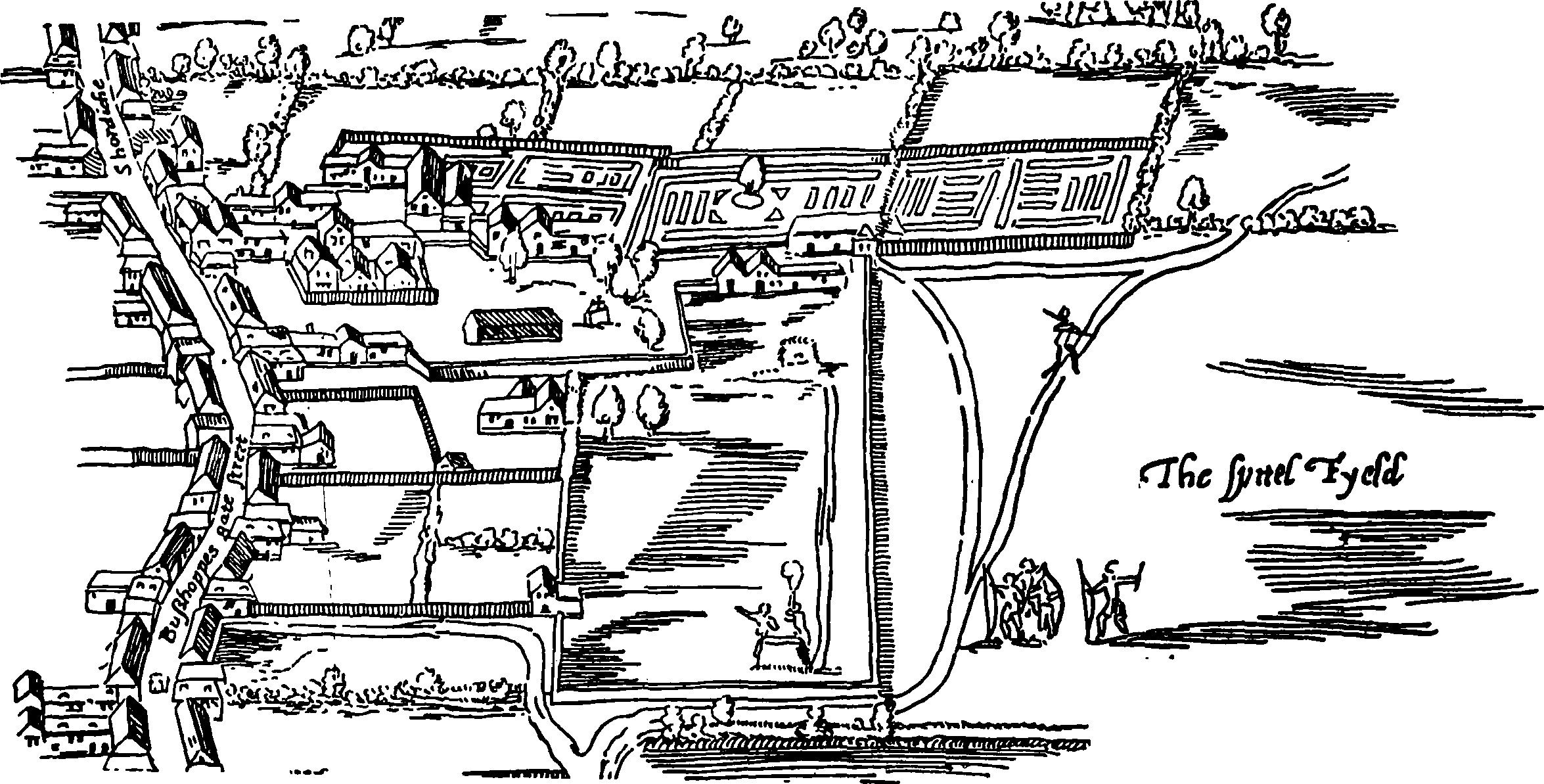
Extract from Agas's map showing site of St. Mary Spital and the Old Artillery Ground, c. 1560–70
Vaughan's reply consisted chiefly of the asser tion that the prior's lease to White was void be cause it was of property not customarily leased and was made less than a year before the priory's dissolution, the date of the lease (4 March 1537/8) being said to be earlier than its sealing and delivery, which did not occur until November of that year. This was denied by White, who had produced evidence from former brothers and sis ters of the priory that the premises had been occupied by two gentlewomen before the lease to White, and before them by (John) Stokes, and before him, about forty years past, by ’one dokter Smyth a dokter of physsyke’. After Vaughan's death in December 1549 White again petitioned the Court of Requests. (fn. 14) He claimed that Vaughan had been ordered to allow him possession of the premises (a chamber and stables) reserved out of his lease to Pomell and pay him his arrears of rent, but that neither Vaughan nor his executor, John Ewynethe, clerk, had done so. Ewynethe's answer, which he evidently thought sufficient, was that Vaughan had died in debt to the King for the sum of £3,637 12s. 6½d. of which only £1,900 had been paid, and Ewynethe was ’not in a sertenty howe the kynges maiestye shalbe answard of the resydew of the said dett.’.
The outcome of the second petition is not known. In his will (fn. 15) dated 16 October 1549 and proved 26 February 1549/50, Stephen Vaughan had left to ’the kinges maiestie’ some of his property in the priory precinct to the yearly value of £28 16s. 8d. for the period of his son Stephen's minority. This included the tenement over the gate and the garden which was in dispute with White. It was described in Vaughan's will as ’nowe in the holding of Thomas Hustewaite painter for lvi s. viiid. by yere’.
Apart from the property left to the King the only possessions in the priory precinct mentioned in Vaughan's will was ’my mansion howse at St. Mary Spittell with the gardeyn and orcharde thereunto belonging’, which he left to his wife for nine years and then to his son Stephen. Vaughan's possessions ’at St. Mary Spytyll’ were valued at £3765. 8d. per annum. (fn. 16)
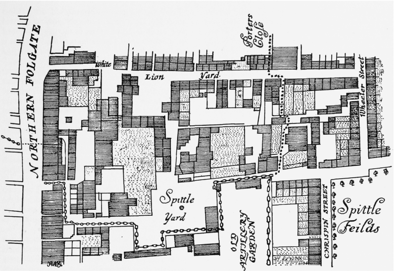
Extract from Ogilby and Morgan's map showing Spital Yard area, 1677
By his will of 15 February 1588/9, proved with codicils on 28 March 1605/6, (fn. 17) Stephen Vaughan left his property in St. Mary Spital, including his ’mancion house wherein I now dwell’ to his third son Rowland Vaughan, the eldest son Stephen being fallen into a kinde of phransie or lunacye and the second son Henry being ’gone I know nott whither’.
The eldest son Stephen was nevertheless seized of a third part of twelve messuages and a close of two acres in St. Mary Spital at the time of his death in October 1637, when they devolved upon his brother Sir Rowland Vaughan, knight. (fn. 18)
At Sir Rowland's death in July 1641 his daughter and heiress Elizabeth, who had married Sir Paulet St. John, second son of Oliver, first Earl of Bolinghbroke, became possessed of the twelve messuages which Sir Rowland had in herited from his brother Stephen and also of an additional eighteen messuages, two gardens and two orchards in St. Mary Spital (including Sir Rowland's dwelling-house), of which Sir Row land had been seized at his death. She was then a widow herself, living, like her widowed mother, at ’le Spittle’. (fn. 19)
In January 1685/6 Lady Elizabeth St. John conveyed to the Hon. Paulet St. John, her second son, her messuages and lands in St. Mary Spital. (fn. 20) In 1688 Paulet succeeded his brother as third Earl of Bolingbroke and died in October 1711 seized of the family property in St. Mary Spital, which he left to William St. John, who in 1714 succeeded Paulet St. Andrew St. John as Lord St. John. (fn. 21) The estate was however mortgaged to Jeremy Sambrook of London and Bedfordshire: the Sambrook interest (fn. 22) in the estate probably dated from at least 1693 when Sir Jeremy Sam brook was listed among subscribers to a fund to relieve distress among Spitalfields weavers. (fn. 23) At the time of the Earls' death in 1711 the first development of the former priory precinct in its modern form had already commenced with the construction of part of the north side of the west arm of Spital Square, on the south side of which the Earl's dwelling-house was situated. In July 1716 the Vaughan-St. John estate was conveyed by William, Lord St. John and others to Isaac Tillard, esquire. (fn. 24) A few years later Tillard acquired property in Spital Square which was probably the only part of the precinct (except for the Old Artillery Ground) not to have come to him already through the Vaughans and St. Johns. It was by the Tillards that the modern street lay out of the former priory precinct was developed and completed.
The Extent of the Precinct
The extent of the precinct at the time of the Dissolution can be indicated only approximately. As has been seen, in the early thirteenth century the priory precinct lay between Bishopsgate Street on the west and Lolesworth field on the east, and was further defined as lying between Shoreditch parish on the north and Berewardeslane on the south. The existence after the Dissolution of the two liberties of Norton Folgate and the Old Artillery Ground affords some presumption that these together represented approximately the limits of the precinct and such evidence as there is goes towards supporting this in the main, although the extension of the Norton Folgate Liberty west of Bishopsgate Street outside the precinct is a warning against a too ready identification of the liberty boundary with that of the precinct.
On the south the precinct in 1538 included the ’Tesell ground’, subsequently the Old Artillery Ground, and presumably the wall of the Ground represented the wall of the precinct. The southern limit of the precinct in the early fourteenth century, Berewardeslane, was said by Stow to join Bishopsgate Street to Hog Lane (now Middlesex Street). The maps of Agas and Faithorne and Newcourt suggest that this lane bordered the southern end of the Old Artillery Ground and is now represented by the western part of Artillery Lane, by Sandys Row and by Artillery Passage.
On the western side of the Old Artillery Ground the precinct did not reach Bishopsgate Street; (fn. 25) as on the southern side, the wall of the ’Tesell ground’ presumably marked the precinct boundary. It is evident that the precinct abutted west on Bishopsgate Street in the neighbourhood of Spital Square. The position of the west gate is not certain but there are said to have been precinct buildings both north and south of it (see page 44). The precinct apparently reached Bishopsgate Street approximately as far north as the present line of Fleur-de-lis Street. In 1743 this was the northern limit of the Bishopsgate Street frontage of the Tillard estate, which derived from Stephen Vaughan's possession of the precinct. (fn. 26) This agrees with the Ministers' Accounts of 1540–1 which include within the precinct two of the tenements known as the ’Crown rents’ (from the adjacent tenement called the Crown) in the parish of Shoreditch (fn. 25) which fronted upon Bishopsgate Street. (fn. 27) No other items within the precinct are said to have been in Shoreditch parish. These two tenements abutted south on the great barn of the priory, which must thus have been situated im mediately south of the then parish boundary in Bishopsgate Street.
The northern boundary of the precinct is not easy to establish with certainty although it probably followed the northern part of the liberty boundary as shown on Ogilby and Morgan's map, turning north along the line now followed by Blossom Street, then east along a line north of Fleur-de-lis Street, thus also following the liberty boundary as shown on the Ordnance Survey maps of 1873–5 and 1894–6. The grant to Vaughan in 1542 (fn. 2) had, in this area, included land north of the precinct, stretching eastward to Lolesworth field. (fn. n3) This land was described in 1538 as abutting south on the land of John Halles. (fn. 28) It is not known with certainty what land Halles possessed at this time, but it may have been the land within the precinct granted to Richard Morysyn in April 1540 which is described in the Ministers' Accounts of 1540–1 as being leased to Halles and which was subsequently alienated to him. This land included ’le Pryours gardeyn’, ’le Covent garden’, and waste ground adjoining, within the precinct, said to measure 544 feet from north to south. (fn. 29) This probably means that it stretched north from the priory buildings and enclosures in the neighbourhood of the present Spital Square to the position of the northern boundary of the liberty and that it included the area designated ’Porter's Close’ on Ogilby and Morgan's map of 1677, and unnamed on their map of 1681–2, immediately south of the liberty boundary.
The eastern boundary of the precinct probably followed, for the most part, the virtually straight line of the eastern boundary of the liberty shown on Ogilby and Morgan's maps and the late nineteenth-century Ordnance Survey maps. This would be consistent, in the period before the building of Wheler and Crispin Streets, with the abutment of the precinct eastward on Lolesworth field or Spitalfields. The boundary appears, however, to have diverged eastward to include ground outside the liberty, bordered in the eighteenth century by White Lion (now Folgate) Street, Wheler Street, Lamb Street and Tabernacle Yard (later Church Passage and now Nantes Passage). The maps of Braun and Hogenberg (c. 1555–72) and Agas (c. 1560–70) indicate the eastward extension of the priory gardens and enclosures in this area, and in the late seventeenth century Sir George Wheler, the owner of this ground, said that it ’is and ever was tithe free as part of St. Mary's Hospitall’ (see page 102). It may be noted that the eastern boundary of the Norton Folgate Liberty at this point is shown rather indeter minately by Ogilby and Morgan.
Position of the Priory Buildings
There is no certain evidence of the exact position of the priory church, cloister and related buildings, but they probably occupied a site near to or north of the later western arm of Spital Square (fn. n4). In 1892 sixteen medieval tiles that may have belonged to St. Mary Spital were found, apparently near the northern corner of the west arm of the Square. They are now in the north aisle of Christ Church, Spitalfields. (fn. 30) It is said, however, that at the period of the refoundation in about 1235 a new church was built eastward of the old (see page 21) and thus presumably stood some way back from Bishopsgate Street. In 1909 during the rebuilding of No. 38 Spital Square part of a twelfth century capital was found (fig. 1), which may have been part of the church.
Wyngaerde's view of a church said to be St. Mary Spital is too distant to indicate its position exactly. Agas's map of c. 1560–70 and Ogilby and Morgan's of 1677, compared with the modern Ordnance Survey maps, suggest that the main priory buildings occupied the north side of the western arm of Spital Square. Agas shows three buildings running north and south, with a large building running east and west across their northern end. Taken together this group may represent the former church and cloisters. Further north several other large buildings are shown, and these may represent ’le oldehalle’, the chapel of St. Mary (but see below, page 49), the hospital and prior's lodgings mentioned in the leases of 1531–40 (fn. 31) (see above) and the convent kitchen, mentioned in a lease of 1580 (fn. 32) (see below). Towards the north-east of the precinct Agas indicates ornamental gardens which may be identifiable with ’le Pryours gardeyn’, ’le Covent garden’ (fn. 6) and the ’sisters garden’. (fn. 32)
Agas shows an entrance from Bishopsgate Street west of the buildings that perhaps represent the church and cloisters. This entrance ran south on the line of the present Spital Yard, then, where there is now a cul-de-sac, turned east into the open space shown to the south-east of the suggested position of the priory church and cloisters. The open space, containing a pulpit cross and a single storey barn-like structure, represents the priory cemetery, which extended south to the northern boundary of the Teasel or Old Artillery Ground, and on the east included the sites of the later Nos. 30, 31 and 32 Spital Square. The pulpit cross is clearly marked on Ogilby and Morgan's map. The site was subsequently occupied by the back part of No. 32 Spital Square, the street front of which stood approximately fifty feet north of the site of the cross. The site is now occupied by the open roadway of Steward Street since its widening eastward at the time of the Spitalfields Market extension.
At the pulpit cross or Spital cross were preached the Spital sermons, attended by the Lord Mayor and Aldermen and by the masters and children of Christ's Hospital, on the Monday, Tuesday and Wednesday after Easter, in connexion with others preached on Good Friday and Low Sunday at St. Paul's Cross. The Spital sermon and cross probably date from at least 1398, as Stow records that in that year Richard II caused the papal con firmation of certain statutes and ordinances to be proclaimed ’at Pauls Crosse, and at saint Marie Spittle in the sermons before all the people’. (fn. 33) The chronicle of William Gregory, skinner and Lord Mayor of London in 1451, (fn. 34) says only that the confirmation ’was pronounsyd at Powlys Crosse and at Synt Mary Spetylle by fforme and in audyence of pepylle’. Stow records a bequest to the three preachers ’at the Spittle’ in 1439. (fn. 35)
Pepys twice notes his attendance at the Spital sermon. In 1662 he was there in time to see the arrival of ’my Lord Mayor and the blew-coat boys … and a fine sight of charity it is indeed’, although he left after an hour of the sermon, ’a Presbyterian one’. In 1669 it was again ’a dull sermon’ but he stayed to see the departure of the civic dignitaries and their wives, ’and, indeed, the sight was mighty pleasing’. (fn. 36) The sermon continued to be preached here until at least 1680: (fn. 37) the Old Artillery Ground plan probably of 1680/1 describes its northern abutment as ’The Spitle where my Ld Maior & Citty meet in Eastre week’ (Plate 54c).
According to Stow the Lord Mayor and Aldermen ’were accustomed to bee present in their Violets at Paules on good Fryday, and in their Scarlets at the Spittle in the Holidayes, except Wednesday in violet …’. In 1488 a house was built for their reception with a bequest made in 1477 by Richard Rawson, Alderman and Sheriff, and Isabell his wife. Stow describes it as a ’faire builded house in two stories’, in the upper of which, over the Mayor, ’the Bishop of London and other Prelates’ used to stand and now ’the ladies, and Aldermens wives doe there stand at a fayre win dow, or sit at their pleasure’. (fn. 38) It was situated south of the pulpit cross and may be the building apparently south-west of the cross shown on Agas. Stow records that in 1594 ’this Pulpit being old, was taken down, and a new set up, the Preachers face turned towardes the south, which was before toward the west’. (fn. 35)
The sermons were attended by the masters and children of Christ's Hospital. A contemporary writer described the sight on 3 April 1553 when there ’whent unto saynt Mare spytyll, onto ye sermon, alle ye masters and rulars, and skollmasturs and mastores [mistresses], and alle ye chylderyn, boyth men and vomen chylderyn, alle in plue cotes, and we[n]ssys in blue frokes and with skoychyons in brodered on ther slevys with ye armes of london, and red capes, and so II and II [to-]geder, and evere man in ys plasse and offes; and so at ye Spyttylle [a scaffold?] was mad of tymbur, and coverd with canves, and setes on a boyff a nodur for alle ye chylderyn syttyn on a boyff a nodur lyke stepes and after thrug lon don …’. (fn. 39) In 1594, when the pulpit was rebuilt, a large house was also built on its east side ’for the gouernors and children of Christs Hospitall to sit in’ with a bequest from William Elkens, Alderman, but falling into decay within a year, it ’was againe with great cost repayred at the Cities charge’. (fn. 35) This building or another on its site is shown on Ogilby and Morgan's map, immediately west of the boundary between the precinct and the north-east part of the Old Artillery Ground.
The Priory Gates
The evidence for the position of the west gate or gates to the priory, providing access from Bishopsgate Street, is exceedingly confusing; the conclusion which may tentatively be drawn is that there were two gates, one at the present western end of Folgate Street and one at the present western end of Spital Square. The former is the position customarily given for the gate, the principal evidence being the remains of a stone pier, let into the southern wall of the house on the north corner of Folgate Street, which survived into this century (Plate 61 a) and were described by Ellis in 1798 as possessing an iron staple for merly part of a gate-hinge. (fn. 40)
There is supporting evidence for this site in a recital in 1542 of a lease of 1537/8 to Patrick White of a tenement over and on each side of the west gate. (fn. 2) This describes the gate as abutting west on the King's broad street (letam strat’ nostram), east on the way entering the church, north on the hospital (i.e. priory) and south on the ’Candilhouse’. A garden is said to lie outside the gate, with the tenement leased to White on its north, a cross at the garden gate on its south, the street on the west and the hospital on the east. The exact position of the garden in relation to the gate is not quite clear. By the time of Agas's map (c. 1560–70) there does not seem to be any obvious room for a garden between the west side of the hospital or priory precinct and Bishopsgate Street. But the Candle House is known to have been within the precinct, and this fact, together with the existence of a garden leased with the gate and lying south of it, suggests that the west gate here referred to was appreciably north of the southwest corner of the precinct. In Ogilby and Morgan's map of 1677 and in subsequent maps the division between the Liberty of Norton Folgate and the parish of St. Botolph Bishopsgate is shown to be at or immediately south of the west entrance to Spital Square, and it is unlikely that the precinct fronting Bishopsgate Street ever extended south of this point. This suggests that the gate was further north, perhaps at the present western end of Folgate Street. The hospital precinct is known to have stretched north of this point to the Shore ditch boundary. The position of the Candle House is not known certainly, but if it was in fact immediately south of the west end of Folgate Street, this would be consistent with the known fact that the Candle House site was subsequently considered for one of the sites of a church to be built in Norton Folgate by the ’Fifty Churches’ Commissioners, one of which was on the south side of the western end of White Lion (now Folgate) Street.
There are, however, indications which would suggest that the Candle House may have been situated further east (see page 47). If the designation of the building south of the west gate in 1537/8 as the Candle House is erroneous, then the identification of the gate at the west end of Folgate Street with the main west gate of the priory is weakened. There is in fact evidence that there was another entrance to the priory, perhaps the main entrance, further south, at the later west end of Spital Square. In 1540–1 a tenement of the priory's called ’le Gonnpouder housse’ in the parish of St. Botolph Bishopsgate, and outside the precinct, was described as lying towards the common door (communem portam) of the former hospital, (fn. 41) which suggests that this door was situated at the southern extremity of the precinct, at the later west entrance of Spital Square. Stephen Vaughan in his will of 1549 speaks of a tenement ’within the gate of saint mary Spittell’ and another tenement ’over the gate of the saide Spittell’: he then goes on to speak of other tenements in the precinct distinguished as being ’without the barrs’. This suggests that the gate itself was within the bars and thus probably near the later entrance to Spital Square as the City bars are known to have been situated between Spital Square and Folgate Street, and nearer the former. (fn. 15) Agas's map of c. 1560–70 indicates that there was then some kind of entry near the present west entrance to Spital Square, with a passage to the cemetery. That in the later sixteenth century this may have been the main entrance is suggested by Stow, who in 1598 described the former priory as situated ’hard within the bars’, (fn. 42) which seems to imply that at least the main entrance was south of the bars, near the west end of Spital Square. A lease of properties within the precinct granted by Stephen Vaughan to Robert Hare in 1580 (fn. 32) mentions ’the new gate or passage now and of longe tyme before comonly used owt of the highe strete’ and Stephen Vaughan's dwelling-house. The position of this house is not certain but it was probably immediately south of the later western arm of Spital Square. The descriptions in the lease are not clear, but it does not seem likely that the gateway was situated north of the northern wall of the dwelling-house by a distance of more than sixty-two feet, plus perhaps part of the width of the building known as the ’principal tenement’ (see fig. 8): and this suggests a position of the gateway nearer Spital Square than Folgate Street. The description of the gateway does not clearly indicate whether this entrance way, or the structure over it, had existed before the Dissolution.
There is a reference in 1676 to the residence of a political suspect ’at a house on the left hand as you enter within ye grete gate of ye Spittel’, (fn. 43) which suggests that this gate may have been a remnant of the priory buildings and was perhaps the building called ’very ancient’ in 1715 (see below).
In Ogilby and Morgan's maps a passage from Bishopsgate Street is shown in a position corresponding to that indicated by Agas, and in the early eighteenth century a gateway led out of Bishopsgate Street at the west entrance to Spital Square. One of the plans of the area prepared for the ’Fifty Churches’ Commissioners in c. 1711–12 appears to show a gateway in this position, (fn. 44) although it may not have been an old one, and in July 1716 when Lord St. John conveyed the estate to Isaac Tillard part was specified as ’the New Court or Square within the Spittle Gate’: (fn. 24) this indicates that the gate was at the western entrance to Spital Square, which, although at that time only begun, already formed a wide street or court in a way that White Lion (Folgate) Street did not.
It may be that the main entrance before the Dissolution was in the more northerly position, and that after Stephen Vaughan made his home within the precinct a new or enlarged entrance was used in the more southerly position, the ‘new gate or passage’ mentioned in 1580.
In addition to the two gates fronting Bishopsgate Street there was also a postern on the east side. This was leased by the prior in 1536 to William Wyld (fn. 9) (see below), and is clearly shown on Agas's map at the north-west corner of the Spital Field.
The Candle House and the Brick House
The position of the Candle House and of a building sometimes mentioned in conjunction with it, called the Brick House, is not, despite the lease of the gateway recited in 1542, altogether clear. In 1536 the prior leased to William Wyld, citizen and merchant tailor, for ninety-nine years a tenement within the cemetery, ‘over and against’ the pulpit cross, and also the ‘posterne’ or little house leading to the fields. The tenement was lately occupied by William Kayme, gentleman. (fn. n5) Together with Kayme's tenement was leased the ground on its south side ‘unto the myddes of the iiii Elmes next stonding and growying to the said tenement’. (fn. 9) In June 1540 Christopher Campion of London, mercer, was granted by the King ‘le Candle House’ and also a tenement lately leased to Wyld, probably Kayme's tenement: both of these he was licensed in November to alienate to Wyld. (fn. 46) (fn. n6)
In 1549 Wyld owned the properties leased to him in 1536, one being described as a newly built messuage where the late house called ‘le Postern’ was situated, (fn. 47) and the same properties were owned by Wyld's executor at his death in 1558 or 1559: (fn. 48) the Candle House is not mentioned by name.
In 1573 Mary Wilkinson, widow of John Wilkinson, merchant taylor of London, died seized in fee simple of a capital messuage called the Brick House (identifiable with the ‘postern’) and of another messuage lying on the west side of it, called the Candle House. (fn. 49) In 1582 Vincent Goddard, in performance of trusts created by Mary Wilkinson, gave an annuity out of the Candle House to the parish of St. Botolph without Bishopsgate for the benefit of the parish and of Norton Folgate and in the same year Mary Wilkinson's son Paul gave a similar annuity out of the Brick House. (fn. 50)
The Brick House is identified with the property formerly called the postern in an assignment of the 1536 lease made in 1586 by Raffe Bott of London, gentleman, (fn. 51) who in 1589/90 claimed an interest in the forty-three acres of Lolesworth field lying immediately east of the precinct (fn. 52) (see page 96).
In 1645 the Brick House was evidently owned by (Sir) William Wheler (of Westminster) as he then confirmed the charitable annuity paid out of it. (fn. 53) His will, made in 1665, mentions his ‘Capitall Messuage … in the Spittle yard in the parish of St. Botolph Bishopsgate’: (fn. 54) it is uncertain whether this was the Brick House. In 1719 Isaac Tillard purchased the Brick House. (fn. 55) This purchase may well be that which in 1727 he claimed to have made from Sir George Wheler and others, after May 1717, at the instigation of the ‘Fifty Churches’ Commissioners, as a possible site for a church in Norton Folgate, near to a site already suggested. (fn. 56) This ground was on the north side of the eastern arm of Spital Square ‘bounded round by an old brick wall of an oblong square’ (seepage 61).
This position for the Brick House is that which the original lease to Wyld would seem to indicate when compared with Agas's map, on which the tenement north of the four elms and the postern seem to be shown approximately on the line of the later eastern arm of the Square. It is also consistent with the ownership of the Brick House by the Wheler family, the bulk of whose estate adjoined the east side of the precinct.
There is some further support from a plan made for the ‘Fifty Churches’ Commissioners which describes part of the ground on the north side of the eastern arm of the Square forming the suggested site for a church, as ‘belonging to the Parrishrsquo;. (fn. 57) The Brick House or Candle House are the only properties within the precinct to which this description is known to have been appropriate. (fn. n7)
It is difficult to explain the occurrence of ’le brik howse' in the Ministers’ Accounts of 1540–1 when it is said to be held by John Halles, gentleman, under an eighty-year lease of 1538. (fn. 58) The reversion of this lease was granted in 1542 to Stephen Vaughan, (fn. 2) who mentions the Brick House among his possessions in his will of October 1549. (fn. 59) This is difficult to reconcile with Wyld's ownership of the postern in 1549.
The Candle House was said in 1711 and again in December 1717 to have ’gone to ruin’ and was conveyed in the latter year to trustees for sale. (fn. 60) Isaac Tillard made a purchase in 1719 which certainly included the Brick House and probably also included the Candle House. As recited in 1851, the deed of purchase in 1719 only specifically included the Brick House but appears to have related also to Vincent Goddard's grant out of the Candle House and henceforward ’both the Candle House and the Brick House were regarded as freed from the trusts’. (fn. 61)
Much of this evidence suggests that the two buildings were adjacent or near to each other. Both were owned by Christopher Campion in 1540 and by Mary Wilkinson in 1573 when the description of them seems to imply juxtaposition or propinquity (see above): that they were both subject to a similar rent-charge suggests the same, as does the fact that, at least from the later sixteenth century, neither seems to have belonged to the Vaughan-St. John estate. On this interpretation part of the ground described on the Guildhall Library plan as belonging to the parish might well be the site of the Candle House, east of the Vaughan-St. John estate and west of the Brick House.
The fact that the sites on the south side of Folgate Street were proposed in 1711–17 for a new church by the owners of the St. John-Tillard estate suggests that the ground was all within that estate, and that the Candle House, whose site was considered in 1713 by the inhabitants of the liberty for the erection of a church, was, like the Brick House, on the ground marked as belonging to the parish at the west end of the eastern arm of the Square, where a church is indicated on some plans.
Nevertheless the Candle House was explicitly stated in 1537/8 to have been south of the west gate, abutting west either on Bishopsgate Street or a garden between the priory and the street (see page 44). If the west gate was at the end of White Lion (Folgate) Street the Candle House must have made a gap in the Vaughan-St. John estate which reached Bishopsgate Street north and south of it, and whatever the exact position of the west gate, must, according to this, have been an appreciable distance from the probable site of the Brick House.
Domestic Buildings in the Precinct in 1580
A considerable amount of information about the new and old buildings within the precinct in 1580 is contained in a lease of that year granted by the younger Stephen Vaughan to Robert Hare, (fn. 32) but not in such a way that the layout can be accurately determined (fig. 8). The chief property leased was described as a ’principal tenement or messuage … sumtyme in the tenure and occupacion of Edward Isaake’ of the parish of Wall in the County of Kent, gentleman, deceased. The consideration for which the lease was granted was said to include ’the greate coste and chardge which the said Robert Hare heretofore hath bestowed and hereafter intendeth to bestow in buylding repayringe and amending’ the principal tenement. Also leased was ’one old hall or buylded rome adioyninge to the Northwest side of the said principall tenement’, sometime in the tenure of Robert Grigges, currier, containing from east to west forty-four feet and north to south twenty-four feet, together with ’somuche in bredthe of the back yearde or voide grownde on the Northe side of the said olde halle as reacheth from the saide olde hall to the gutter conveyinge the water from the olde howse sumtyme the co[n]vent kitchen to the com'on sewer of the saide Steven Vaughan, And in length from the said convent kitchen unto the olde wail of flynt stone devidinge the said backe yearde from a garden sumtyme called the sisters garden'. A parcel of ground lying on the east side of this back-yard between the ’principal tenement’ on the south and the gutter on the north was included in the lease ’and also over the said gutter one parcell of grounde more lyenge before the west side of the tenement of stone buyldinge wherein Robert Maneringe dwelleth’ measuring on its east side thirteen feet northward from the north side of the door into Maueringe's dwelling, forty feet east to west, and fifteen feet on its west side.
All this lay north of the ’principal tenement’. Also leased, on its west, was ’somuche of the great base courte or yearde belonginge to the said Steven as lyeth alonge before the said principall tenement from a new pale (there erected by the said Steven) northwards to the foresaid olde hall', apparently measuring twelve feet square, with free access for carts and horses to the principal tenement through the court ’at the new gate or passage now and of longe tyme before comonly used owt of the highe strete’.
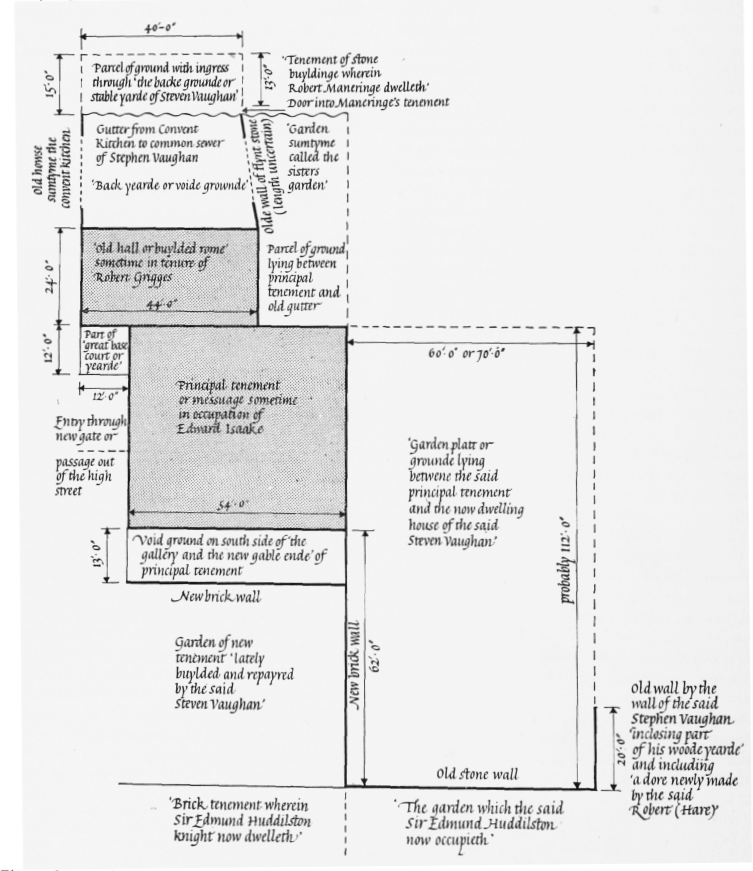
Suggested reconstruction of part of Stephen Vaughan's ground, 1580. Based on a lease in the Bodleian Library
On the south side of the principal tenement was a piece of void ground ’lyinge and beinge alonge on the south side of the gallery and the new gable ende of the said principall tenement’, enclosed within walls and measuring fifty-four feet east to west and thirteen feet north to south. On the south side of this void ground was a ’new brick wall’ dividing it from the garden of ’the new tenement lately buylded and repayred by the said Steven Vaughan’.
This garden appears to have extended eastward beyond a wall, to Stephen Vaughan's house, as the lease included ’one garden platt or grounde lying betwene the said principal tenement and the now dwelling howse of the said Steven Vaughan’, of which the east to west dimension was 60 feet and the north to south dimension probably 112 feet. It included also ’the dead walles or inclosures compassing and inclosing the said garden, That is to saye the new bricke wall extendinge sowthwarde from the sowthest [side] of the said new gable ende toward the brick tenement wherein Sir Edmonde Huddilston knight now dwelleth’ containing 62 feet in length, and the old stone wall ’lyeinge square from thense easteward’ containing probably 70 feet in length, abutting ’alonge upon the garden which the said Sir Edmonde Haddilston now occupieth’, and one other old wall ’turninge square from thense northward by the wall of the said Steven Vaughan inclosinge parte of his woodeyearde’, containing in length 20 feet, with free ingress ’at a dore newly made by the said Robert [Hare] throwghe the same wall’
Not all the dimensions are given and the relative positions are not always clear, but the apparent position of Stephen Vaughan's dwelling-house south-east of the leased ground may well correspond to the position of the house later occupied by the Earl of Bolingbroke and the Tillards, and the entrance from the high street to the present western part of Spital Square. The old hall, convent kitchen and sisters' garden north of this suggest that the position of the main priory build ings was on the north side of the western arm of Spital Square.
The ’oldehalle’ of this 1580 lease is mentioned in the grant to Stephen Vaughan in 1542, (fn. 31) where it is said to have been leased, together with a ’garden platte’ between the church and the Brick House wall, to Joan Rosse, widow, in 1538, evidently in extension of a lease of 1531. The grant to Vaughan also includes a tenement leased with an adjacent fenced garden to John Apott in 1537: this is described as lying between the tenement then of Joan Rosse on the east, the road to the churchyard on the south and west, and the chapel of St. Mary called ’le Hall Pace’ and the former hospital on the north. If Joan Rosse's tenement here mentioned is the ’oldehalle’ this evidently lay sufficiently far east for the chapel and hospital to lie north-west of it. (fn. n8)
Occupants of the Former Precinct
The occupants of the former precinct after the Dissolution included persons of some rank and distinction. The will of Stephen Vaughan, made in October 1549, mentions ’one tenement within the gate of Saint mary Spittell nowe in the tenure of Sir Thomas Wyatt, knight’; (fn. 15) this was presumably the conspirator against Queen Mary, although Wyatt seems to have been abroad from 1544 to 1550. (fn. 1) Vaughan's will also mentions the Brick House as being ’nowe in the holding of the Soveragan of Norwiche’, that is, William Rugg, Bishop of Norwich from June 1536 to January 1549/50.
In 1578 a list of names and addresses of Papists included ’Lord Chidiock Paulet, the Spittle, Without Bishopsgate’, presumably the third son of William Paulet, Marquess of Winchester. (fn. 62) Mentioned next in the list are ’Rob. Hare and Saunders of the Inner Temple, who repair to Lord Paulet’. (fn. 62) Two years later in 1580, as has been seen, buildings within the precinct were leased to Robert Hare, who in 1558 had been in the Marquess of Winchester's service. Hare was the second son of Sir Nicholas Hare, Master of the Rolls, and a Roman Catholic antiquary of note; he presented a valuable collection of historical material to Cambridge University. (fn. 1) In 1558 he was one of the witnesses of the younger Stephen Vaughan's will. (fn. 17) In January 1591/2. Hare, described as of the City of London, gentleman, assigned the lease to his brother, Michael Hare of Bruisyard, Suffolk, esquire, (fn. 63) but apparently he continued to live in St. Mary Spital, and in March 1606/7 he made, as of that place, an assignment of the same lease, and of another lease of 26 March 1582, to Edward Hobart of Hales Hall, Loddon, Norfolk, and Robert Hobart of Clifford's Inn, gentleman. (fn. 64) In April 1609 his previous assign ment to his brother Michael was also assigned to Edward and Robert Hobart. (fn. 63) The premises in the Spital appear, however, to have been occupied by their brother, Sir John Hobart, from January 1607/8. An undated early seventeenth-century manuscript gives a list of ’thinges remaynyng in Sir John Hobartes gallery at the Spitell’ (evidently the gallery of the ’principal tenement’ referred to in the lease of 1580), which ’are belonging to Robert Hare’. (fn. 65) This comprised twenty-nine pictures, including one of Christ, one of ’our lady’, one of ’King Ferdinando’, two of Bishop John Fisher, one of the Emperor Charles V, one of ’Hadrian Cardinally’, one of St. Michael and one of Hare's former patron, William (Paulet), Marquess of Winchester. Also included was ’a small table of St. Hierome’ and another ’of the tower of babilon’, ’a carde for the see in parchment in a frame’, ’Mr. Sekforde's mappe of England in a frame’, ’a great mappe of the world in a frame’, other framed maps of Cambridge, Oxford, Europe, Ireland and Milan, and framed ’tables’ of the vice chancellors and proctors of Cambridge and of ’the orders of Angelles and the 9 beatitudes’. Sir John Hobart received letters addressed to him at St. Mary Spital from January 1607/8 to Novem ber 1611. (fn. 66) He presumably continued to reside there until his death in 1613, as he was buried at St. Botolph Bishopsgate on,7 July 1613; he was then described as ’Sir John Hobarde, Knighte, a mercifull man to ye poore’. (fn. 67) A Mr. John Hobart still occupied the house ’att the Spittle’ in 1650 as a tenant of Lady Elizabeth St. John, who in that year required him to put the house in repair. (fn. 68)
At the time that the principal tenement and other buildings had been leased to the Roman Catholic Robert Hare, other neighbouring premises, presumably within the precinct, had been occupied by Sir Edmund Hodleston (see page 49). A Sir Edmund Huddlestone, knight, of Sawston Hall, Cambridgeshire (which he built about 1580), was of a family noted for its ad herence to the Roman Catholic faith and it may be that it was he who occupied the house in St. Mary Spital.
In 1599 the Jesuit Father Garnet had a house in London ’in a place called Spital’, probably the precinct of St. Mary Spital, and it was also prob ably from this house that another Jesuit priest, John Gerard, rode into the country after his escape from the Tower in 1597. (fn. 69)
In his history of Shoreditch Ellis says that Sir Horatio Palavicino resided within St. Mary Spital, (fn. 70) but his house appears to have been on the west side of Bishopsgate Street. (fn. 71) An occupant of the precinct in the early seventeenth century was Alexander Nevile, the author of an account of Kett's rebellion and brother of Thomas Nevile, Dean of Canterbury; (fn. 1) he is described in his will as ’of St. Marie's without Bishopsgate commonly called St. Maries Spitle …. Esquier’. His will does not indicate the position of his house but refers to books in his study, and bequests to his cook, butler and cater. (fn. 72) In August 1627 Lady Elizabeth Gilford, wife of Sir Henry Gilford and daughter of the Earl of Worcester, died 'at hir house in St. Mary Spittle’. (fn. 73) Probably in the following year, a Jesuit priest, ’Mr. White, alias Black and Browne’, was thought to be residing ’at Spittle’ with Lady Digby. (fn. 74)
In 1632 the Vaughan property within the pre cinct included, besides Sir Rowland Vaughan's dwelling-house, ’that great messuage tenement or mansion house then or formerly in the tenure of Richard Lord Weston, Lord Treasurer of Eng land, and John Mayne’. (fn. 75) Weston, the Roman Catholic diplomatist and financier, was created first Earl of Portland in February 1632/3: it is not known how long he resided in St. Mary Spital. (fn. 1)
The indications that the Spital precinct was a fashionable place of residence are borne out by Stow, who in 1598 wrote that ’in place of this Hospitall, and nere adioyning, are now many faire houses builded, for receipt and lodging of worshipfull persons’. (fn. 76) Its position within the Liberty of Norton Folgate probably made it attractive to adherents of the Roman Catholic faith.
In the late seventeenth century Doctor Samuel Annesley, minister of a Nonconformist meetinghouse in Little St. Helen's Place, Bishopsgate, and father of John Wesley's mother, Susanna, lived in Spital Yard, dying there in 1696.
Susanna was born in 1669 at the house, which was perhaps that at the southern end of the present Spital Yard, just within the City boundary. (fn. 77)