Survey of London: Volume 40, the Grosvenor Estate in Mayfair, Part 2 (The Buildings). Originally published by London County Council, London, 1980.
This free content was digitised by double rekeying. All rights reserved.
'Oxford Street: The Development of the Frontage', in Survey of London: Volume 40, the Grosvenor Estate in Mayfair, Part 2 (The Buildings), ed. F H W Sheppard (London, 1980), British History Online https://www.british-history.ac.uk/survey-london/vol40/pt2/pp171-173 [accessed 30 April 2025].
'Oxford Street: The Development of the Frontage', in Survey of London: Volume 40, the Grosvenor Estate in Mayfair, Part 2 (The Buildings). Edited by F H W Sheppard (London, 1980), British History Online, accessed April 30, 2025, https://www.british-history.ac.uk/survey-london/vol40/pt2/pp171-173.
"Oxford Street: The Development of the Frontage". Survey of London: Volume 40, the Grosvenor Estate in Mayfair, Part 2 (The Buildings). Ed. F H W Sheppard (London, 1980), British History Online. Web. 30 April 2025. https://www.british-history.ac.uk/survey-london/vol40/pt2/pp171-173.
The Development of the Frontage
Not much is known about the development and early appearance of this part of what was until the 1750's promiscuously called the Tyburn, Uxbridge, Oxford or Worcester Road. From 1721 the road was administered by a turnpike trust which set up a gate at the junction with Park Lane (then Tyburn Lane). The stretch west of the Banqueting House Bridge, which carried the road across the Tyburn stream near the present corner with Davies Street, was until 1770 surfaced merely in gravel and not such as to encourage speedy development. Close to the narrow bridge itself, the road was execrably maintained, and 'carts were daily overturning there' before the turnpike trust was able to improve matters in the 1730's. (fn. 1) Another inhibition was an old water pipe running parallel to the road a little to its south, from the corner with Tyburn Lane. This carried water to the City of London from springs at Paddington; there were conduit heads at two points, just east of the corners with North Audley Street and Park Street, and tenants of the buildings eventually erected along its length were obliged to allow access to the system. (fn. 2)
Consequently, the original takers of plots with frontages towards the Oxford Road in the 1720's were inclined to view this district as back land and let it out for building gradually and piecemeal. The background of Sutton Nicholls's engraving of Grosvenor Square, which should not be taken too literally but offers a rough indication of progress in the 1730's, still presents a very rural appearance along the road. Rocque's map of 1746 shows that building had then progressed only as far as North Audley Street; but there was still a large gap at the corner with Davies Street, where buildings were not erected until the 1750's (fn. 3) (Plates 1, 2, 5a in vol. XXXIX).
More rapid changes began after 1760, following the development of the Portman estate along the north side of Oxford Street west of Marylebone Lane. The land between North Audley Street and Park Lane was now at last developed, by agreements of 1764–5 with John Spencer and John Phillips, carpenters. (fn. 4) West of Park Street, Phillips was able to organize the building of some distinctly fashionable private houses including Camelford House (Plate 69a, 69b, 69c), and Hereford Street was squeezed in here.
The developments between North Audley Street and Park Street were simpler, but Tallis's view shows one striking house, then No. 252, which stood on a narrow frontage close to Park Street. Though first built in about 1769 by Joseph or Joshua Saunders, carpenter, (fn. 5) its elegant plan and façade, with a curving porch on columns, a pedimented window on the first floor and a Diocletian window, were doubtless the result of alterations by his architect son George Saunders, whose office was at this address until his death in 1839. (fn. 6)
Of the buildings illustrated by Tallis, one other is worth notice, the then No. 269 between Queen (now Lumley) Street and George (now Balderton) Street. This was the Oxford Street front of the extensive works of Joseph Thrupp, the most enduring of several firms of coachbuilders established hereabouts, and latterly called Thrupp and Maberly. The building had perhaps been inserted in about 1810 in place of a simple archway leading into the works. Tallis in 1838–40 shows a three-storey building with a shop front and round-headed windows above recessed in giant arches at second-floor level. In 1857–8 the building was extended and the façade given a weighty Italianate treatment by the architects F. J. and H. Francis, which, however, reproduced the giant arches (fn. 7) (Plate 45b). It may parenthetically be noted that Oxford Street tradesmen who were also manufacturers and occupied premises west of George Street, were quite tidily accommodated, having good back access to their workshops from North Row, a lane close behind. But for Joseph Thrupp and other large businesses east of George Street, there was no convenient mews behind because of the casual way in which this sector had been developed; so their premises tended gradually to sprawl back and encroach upon once-independent houses in the side streets. (fn. 8)
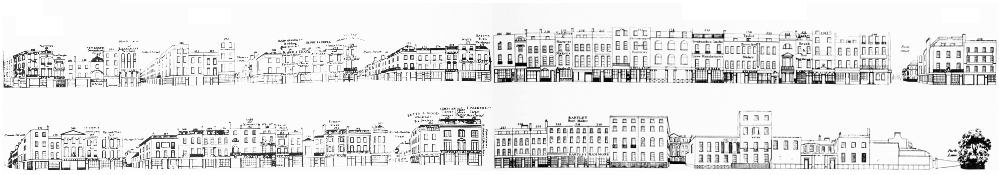
Oxford Street, the Grosvenor estate frontage in c. 1838–40. All demolished
To return to the progress of eighteenth-century Oxford Street, in 1770 maintenance of the road was transferred to the St. Marylebone Paving Commissioners, who immediately paved this sector and brought it up to the high standard of the rest of the street. (fn. 9) By 1780 the frontage up to Park Lane was completely developed, and public executions having shortly afterwards ceased at Tyburn, any stigma still attached to this western end was removed. Oxford Street now enjoyed its first heyday as a centre for retailing, and it became fashionable to promenade along its whole length. One foreign visitor, Sophie von La Roche, records her impression in 1786. 'Just imagine … a street taking half an hour to cover from end to end, with double rows of brightly shining lamps, in the middle of which stands an equally long row of beautifully lacquered coaches, and on either side of these there is room for two coaches to pass one another; and the pavement, inlaid with flag-stones, can stand six people deep and allows one to gaze at the splendidly lit shop fronts in comfort … Up to eleven o'clock at night there are as many people along this street as at Frankfurt during the fair, not to mention the eternal stream of coaches. The arrangement of the shops in good perspective, with their adjoining living-rooms, makes a very pleasant sight. For right through the excellently illuminated shop one can see many a charming familyscene enacted: some are still at work, others drinking tea, a third party is entertaining a friendly visitor; in a fourth parents are joking and playing with their children.' (fn. 10)
There was, however, one development of this time, the St. George's Market, which certainly detracted from local salubriousness. This was a butchers' market founded in 1785–6 without any agreement with Earl Grosvenor in a quite restricted yard between James (now Gilbert) Street and Davies Street, with access at either end from Oxford Street and Chandler (now Weighhouse) Street. It was the project of Henry Tomlinson, a plumber and glazier of St. Marylebone with interests in the development of Hans Town. Tomlinson took a thirty-five-year lease of the ground and erected what must have been twenty very small houses. (fn. 11) Complaints soon arose from the inhabitants of the Grosvenor Market (see page 68), which was erected at just this time very close by in Davies Street and was officially supported by Earl Grosvenor; and in 1791, when St. George's Market was put up for sale, they petitioned the Earl to suppress it. (fn. 12) Nevertheless the market continued until the original lease ran out, at which time Tomlinson's houses disappeared. Even then St. George's Market did not die out, and butchers and cheesemongers were to cluster in this part of Oxford Street and stalls were to encumber passers-by for many years, attracting unfavourable comment from The Builder as late as 1867. (fn. 13)
The construction of Regent Street from 1813 onwards considerably diminished the lustre of Oxford Street as a fashionable thoroughfare, and for the next fifty years the Grosvenor estate's part of it was in decline. There were a number of rebuildings of commercial premises, some of them visible on Tallis's illustrations, but nothing of real consequence. Among the shopkeepers who advertised on his drawings was the aptly named Mary Mash, potato dealer. No. 260 between North Audley Street and Park Street was between 1806 and 1852 occupied by the speculative architects and surveyors Robert William Jearrad senior and junior and Charles Jearrad. The Jearrads were most famous for their developments in Cheltenham, but Charles and the younger R. W. Jearrad were successively surveyors to the St. George's Vestry. The family performed some minor works on the estate, though not apparently in Oxford Street. (fn. 14)