Survey of London: Volumes 43 and 44, Poplar, Blackwall and Isle of Dogs. Originally published by London County Council, London, 1994.
This free content was digitised by double rekeying. All rights reserved.
'Between Poplar High Street and East India Dock Road: Castor, Morant, Oriental and Hale Streets', in Survey of London: Volumes 43 and 44, Poplar, Blackwall and Isle of Dogs, (London, 1994) pp. 171-173. British History Online https://www.british-history.ac.uk/survey-london/vols43-4/pp171-173 [accessed 26 April 2024]
In this section
CHAPTER VII - Between Poplar High Street and East India Dock Road, and All Saints' Church
Before the building of the East India Dock Road in 1806 the only roads running north from the High Street were North Street, leading to Bow Common, and Bow Lane and Robin Hood Lane, which merged to form a single road leading to Bromley. Several buildings had appeared along North Street by the late sixteenth century (Plate 145a), and by the early 1700s some building had taken place on the east side of Bow Lane and the west side of Robin Hood Lane, at their southern ends. (fn. 1) The setting out of East India Dock Road and West India Dock Road at the beginning of the nineteenth century provided an incentive to development, forming a block of land bounded by those roads on the north and west, on the south by the premises in the High Street and on the east by the boundary wall of the East India Docks. Even so, new building was slow, perhaps because the rents from the small houses characteristic of early nineteenth-century Poplar produced an income not appreciably greater than that obtained from keeping the land in use as pasture and garden. (fn. 2) There was also a ropewalk north of Pennyfields— along the alignment later followed by Church Path—and the East India Company's land on which its almshouses and Poplar Chapel stood. The development of the eastern end of this block of land began in the first decade of the nineteenth century and, at its western end, Castor Street was laid out by 1812, but not until the 1850s and 1860s was the space between the High Street and the East India Dock Road filled up, except for the East India Company's land, which became a recreation ground.
Castor, Morant and Oriental Streets
The ground to the north of Pennyfields, as far as East India Dock Road, was held in the early nineteenth century by Miss Mary Burch, of St George's-in-the-East (see page 132). Perhaps encouraged by the development generated by the East India Dock Road, in 1812 she granted a number of leases in the recently laid out Castor Street. (fn. 3) The lessees included two carpenters, a bricklayer and a builder, and a number of small houses were erected in Castor Street and Sandpit Road (later West Street, from 1875 Birchfield Street) (fig. 59). It was entirely characteristic of developments in Poplar at that time that, although not all of the street frontages were filled, five houses were erected in a narrow court off the north side of the street. The court was pretentiously named Vulcan Street. (fn. 4) No doubt the 31-year term granted by Miss Burch was too short to encourage a higher standard of building. The reputation of the neighbourhood was no better: in 1840 some of the occupiers of adjoining premises complained of the filth 'of every kind' in Castor Street, and commented that 'it is quite impossible for any respectable persons to avail themselves of it, as a short road to Limehouse'. (fn. 5)
By 1832 the Langley family had acquired the land from Miss Burch. (fn. 6) Further development was carried out in the 1850s, under the ownership of Joel Langley of Limehouse, shipowner. From about 1855 Joseph and George Mills established a cooperage in Castor Street and from c1886 Lancaster & Bawn, iron tank manufacturers, took over premises on the south side of the street. (fn. 7) In the 1930s these brick-and-slate workshops and offices were still owned by the heirs of Langley and Bawn, and the tank works were run by William Byron Bawn & Company until c1940 (see page 117). (fn. 8) Joel Langley also initiated new residential development. The local architect E. L. Bracebridge (1812–92), who designed a terrace of three houses for Langley at Nos 78–82 East India Dock Road, set out Morant and Oriental Streets in 1857 between Castor Street and the rear of Langley's houses in East India Dock Road (see page 155). By 1859 the two streets contained 19 completed houses and nine others in the course of construction, and by c1870 there were 85 houses together with the Oriental Tavern. (fn. 9)
In 1878 an extension of Morant Street eastward on to J. W. Perry Watlington's land was approved, superseding an unexecuted plan to extend Perry's Close. Sheffield & Prebble of Bromley built 26 houses in the extension and four others in North Street. They were of slightly unusual construction for their date, with the party walls and 'a small portion of the external walls' of concrete, although the external walls were chiefly of brick. (fn. 10)
Some of the properties in the three streets were cleared following bomb damage in the Second World War, but others remained until acquired in the 1960s for the Saltwell Street housing scheme (see page 94).
The Wade Estate
The Wade estate lay to the north of Poplar High Street and extended into Bromley. It had been in the hands of the Wade family since the early 1700s, and a century later was held by Mary Wade, a widow (see page 58). The East India Dock Road, set out in 1806–12, cut across the estate, and that part between the new road and Poplar High Street was first developed in the early nineteenth century. Wade Street and Wade's Place were set out and building lots along them were sold in 1808–10. (fn. 11) Development on the remainder of that part of the estate was more haphazard, with Noble Street running in a north-easterly direction from High Street and a number of short streets and courts built off it. (fn. 12) This area was developed on a short lease, and by 1815 contained 'a great number of very small and dilapidated Tenements' where, it was said, the 'scenes which have so long been exhibited … are so destructive of the Morals and dangerous to the Peace and security not only of the Neighbourhood, but of all Persons passing through it'. (fn. 13) The lease expired in 1818 and more systematic development followed the division of the land among Mary Wade's daughters and their husbands in 1823. A modified street layout was created between Wade's Place and Hale Street—Noble Street was cleared away—and building took place during the remainder of the 1820s and in the 1830s (fig. 59). (fn. 14)
By the late nineteenth century this area of small terraced houses had developed an unenviable reputation. The vicinity of Sophia Street and Rook (formerly Mary) Street was described as 'a regular Irish den … all the vices of the Irish rampant, murder, rows, riot etc… . and fat brawny brawling women shouting at one another'. (fn. 15)
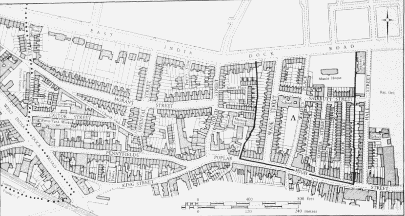
The Morant Street area, the southern part of the Wade estate (A), and Hale Street. Plan based on the Ordnance Survey of 1894–6
The Holy Family Roman Catholic School, Wade's Place.
Originally the school comprised a chapel, house and school erected in Wade Street in 1818. (fn. 16) Until 1908 it was known as the Wade Street School and from 1908 until 1983, SS Mary and Joseph's Roman Catholic School. (fn. 17) The mid-nineteenth-century buildings were remodelled in 1905 and extended in 1922. A separate building was erected in 1929, bringing the capacity of the school up to 1,000 places for boys, girls and infants. (fn. 18) The present buildings consist of the two-storey 1929 block, designed by Thomas H. B. Scott, with additional classrooms constructed in the mid–1970s. (fn. 19)
Sophia Street Wash-house (demolished).
The washhouse was built in 1930–1 by Poplar Borough Council to provide the laundry facilities hitherto available in the baths and wash-house building in East India Dock Road (see page 164). In 1929 it was decided to transfer the laundry elsewhere, because there was not room for it in the proposed new baths building. (fn. 20)
A part of the Lower North Street and Sophia Street Improvement Area, formerly occupied by Nos 1–4 Sophia Street, was acquired. The wash-house was built by direct labour to the designs of Harley Heckford, the Borough Engineer and Surveyor, at a cost of £6,091. (fn. 21) The machinery and plant was supplied by Messrs J. J. Lane of Old Ford Road for £2,035. (fn. 22) The red-brick single-storey building was well equipped, with six washing machines, generous hand-washing facilities, and 18 drying cham bers. (fn. 23) The coal-fired boilers were converted to oil firing shortly after the opening of the building, and reconverted to coal firing in 1933. (fn. 24) Both conversions were undertaken because of comparative fuel costs.
In 1932–7 the wash-house had an average of 13,850 users each year, (fn. 25) but by the late 1950s the number had dropped to 7,540. (fn. 26) The machinery had become obsolete by the 1950s and the increasing availability of domestic washing machines had also reduced the demand. Consequently, a double shop unit in Aberfeldy Street in South Bromley was adapted by the Borough Council as a launderette, and the Sophia Street establishment closed in 1961. (fn. 27) The building was later demolished.
Hale Street
Hale Street was set out in the early 1800s on the land of Thomas Hale, a builder of Bush Lane, Cannon Street. (fn. 28) It contained seven houses by 1805 and 19 by 1826. (fn. 29) Initially, its passage northwards was obstructed by Noble Street on the Wade estate, but by 1823 it had been extended to the East India Dock Road.
Wesleyan Chapel (demolished).
The chapel, on the east side of the street, was registered for worship in 1807. (fn. 30) In 1848, following the completion of the new chapel in East India Dock Road (see page 160), there was an unsuccessful attempt to dispose of the site, but instead the buildings were employed as a school. (fn. 31) In 1905 they were condemned as unsuitable for elementary education, 'chiefly owing to the inconvenient accommodation, the awkward and inflammable staircases to the first floor, and the close proximity of the offices to the schoolroom'. (fn. 32) The school was closed at the end of 1906, (fn. 33) although the Sunday school continued to meet there for a number of years. It had been closed by 1937. The two-storey buildings were remembered as being 'far from attractive from the aesthetic point of view'. (fn. 34)