Survey of London: Volumes 43 and 44, Poplar, Blackwall and Isle of Dogs. Originally published by London County Council, London, 1994.
This free content was digitised by double rekeying. All rights reserved.
'Limehouse Hole: The riverside area', in Survey of London: Volumes 43 and 44, Poplar, Blackwall and Isle of Dogs, ed. Hermione Hobhouse (London, 1994), British History Online https://www.british-history.ac.uk/survey-london/vols43-4/pp388-397 [accessed 30 April 2025].
'Limehouse Hole: The riverside area', in Survey of London: Volumes 43 and 44, Poplar, Blackwall and Isle of Dogs. Edited by Hermione Hobhouse (London, 1994), British History Online, accessed April 30, 2025, https://www.british-history.ac.uk/survey-london/vols43-4/pp388-397.
"Limehouse Hole: The riverside area". Survey of London: Volumes 43 and 44, Poplar, Blackwall and Isle of Dogs. Ed. Hermione Hobhouse (London, 1994), British History Online. Web. 30 April 2025. https://www.british-history.ac.uk/survey-london/vols43-4/pp388-397.
In this section
CHAPTER XIV - Limehouse Hole
The riverside district north of Millwall was, until recently, known as Limehouse Hole. The name was in use by the seventeenth century and seems originally to have designated a part of the river itself. (fn. 1) It reflects the area's historically greater links with Limehouse than with either Poplar or the Isle of Dogs. Limehouse Hole can be taken to stretch southwards from the parish boundary to the South West India Dock (Impounding) entrance lock and inland to include Garford Street (Plate 42a; fig. 141). This was one of the first parts of the parish of Poplar to be developed, but almost nothing survives of the early fabric, and the dominating feature in the area is now Westferry Circus (Plate 152). As London's riverside was developed, and Limehouse spread eastwards in the seventeenth century, Limehouse Hole was built up with shipping-related enterprises. These characterized the area into the twentieth century. There were shipbuilders, barge-builders, boat-builders, ropemakers, sailmakers, mastmakers, blockmakers and ship-chandlers, as well as general wharfingers. Away from the river there were other industrial premises, and some houses, most notably on the early nineteenth-century Rosher estate.
The Riverside Area
The Margetts's Ropeyard Site
The eight acres of riverside land immediately south of the boundary between Limehouse and Poplar, empty save perhaps for a few small houses behind the river wall, were leased by Sir Edward and Sir John Yate to John Graves in 1633. Graves was a shipbuilder at the yard on the north side of the boundary, later known as Limekiln Dockyard and then as Dundee Wharf. (fn. 2) The northern part of this property was sublet to George Margetts and, c1650, developed as a ropemaking yard with a wharf, ropehouse, storehouse, houses and a ropewalk. (fn. 3) In 1664 Samuel Pepys visited Margetts's ropeyard and apparently decided to use it to supply the Navy. (fn. 4) The royal dockyards at Woolwich, Chatham and Portsmouth had their own roperies, but that at Deptford did not, and the Margettses were its principal suppliers of cordage in the late seventeenth century. (fn. 5)
In 1662 Margetts acquired the freehold of Graves's eight acres, with an additional 2½ acres to the east. (fn. 6) The estate subsequently passed by marriage to Cornelius Purnell, a Portsmouth shipwright. His son sold part of it in 1717 to Philip Willshire, who acquired the remainder in 1723. (fn. 7) The estate passed through Willshire's family to Edward Emmett, whose heirs retained the property until 1809, when it was sold off in parcels. (fn. 8)
The number of buildings on this land gradually increased. In 1664 the Poplar Commissioners of Sewers built a storehouse south of Margetts's ropehouse, which housed the tools used by the 'marsh-men' to maintain the river wall and foreshore. Another storehouse for the same purpose was built nearby c1696. (fn. 9) By 1694, when several leases were granted, there were more buildings. John Burford took a three-storey warehouse to store fruit for cider-making and built two more warehouses. Other buildings, including the first Marsh Storehouse, and a section of wharf with a crane, were let to Joseph Dent, a shipwright, who in turn assigned his property to Edward Terrett, a joiner, in 1703. (fn. 10) Terrett built a shop and loft for Michael Upston, a blockmaker, in 1705. (fn. 11) By the early eighteenth century the area had become the site of a dense and irregularly grouped complex of houses, warehouses and workshops. (fn. 12) From c1730 to the late 1760s the Hudson's Bay Company held one of the warehouses, which may have accommodated ships' stores or exports, rather than imported furs. (fn. 13)
The ropeyard, which was worked by various lessees from the 1720s, (fn. 14) was taken by William Moffatt c1775, and was held by his partner James Mitchell from 1778 to 1817. Sailmaking became a part of the business, and houses on the north-east side of what later became Emmett Street were converted into a three-storey sail warehouse. (fn. 15) In 1799 Mitchell obtained a patent for an influential method of rope manufacture which involved greater subdivision of cables than had earlier processes, to reduce strain on the fibres. (fn. 16) In 1809 his premises comprised a pantile-covered ropewalk, about 1,000ft long and flanked by spinning grounds, with a yarn house, tarring houses (rope was tarred to protect it from the effects of sea-water), a rigging house, warehouses and timber-built dwelling houses. The northern section of wharf, adjoining Limekiln Dockyard, had become a bargebuilder's premises. The site south of the ropeyard buildings and north of the passage to Limehouse Hole Stairs (Thames Place) was a boat-builder's shed and yard, later used for mastmaking. (fn. 17)
The ropeyard was held by John Robertson from the 1820s to the 1860s, when William Henry Briant converted it to the manufacture of wire. It ceased working in the 1880s. (fn. 18) The site between the ropeyard and Thames Place was redeveloped as Pier Wharf in 1875–6, by Tomkins, Courage & Cracknell, malt factors. Their three-storey granary warehouse was extended in 1881–2 and 1888. (fn. 19) The main ropeyard site and the adjacent barge-builder's wharf were redeveloped with one- and two-storey brick sheds in 1899–1901 as the southern part of the Dundee, Perth & London Shipping Company's Dundee Wharf, most of which was on the Limekiln Dockyard site. The company expanded on to Pier Wharf in 1905, building a two-storey warehouse with cruciform-section iron columns on the ground floor. These parts of Dundee Wharf were let to the London Trading Company in 1910, for the relocation from Wapping of its River Plate Wharf, and from 1916 to 1929 were used for wrapping and packing Oxo cubes. The site was then taken back into Dundee Wharf. (fn. 20) All the buildings on the north side of Thames Place were cleared in 1950–1 for a rebuilding of Dundee Wharf. The river wall north of Limehouse Hole Stairs was then pushed out to align with the rest of the wharf. (fn. 21) Dundee Wharf was cleared in 1990 for the Limehouse Link road.
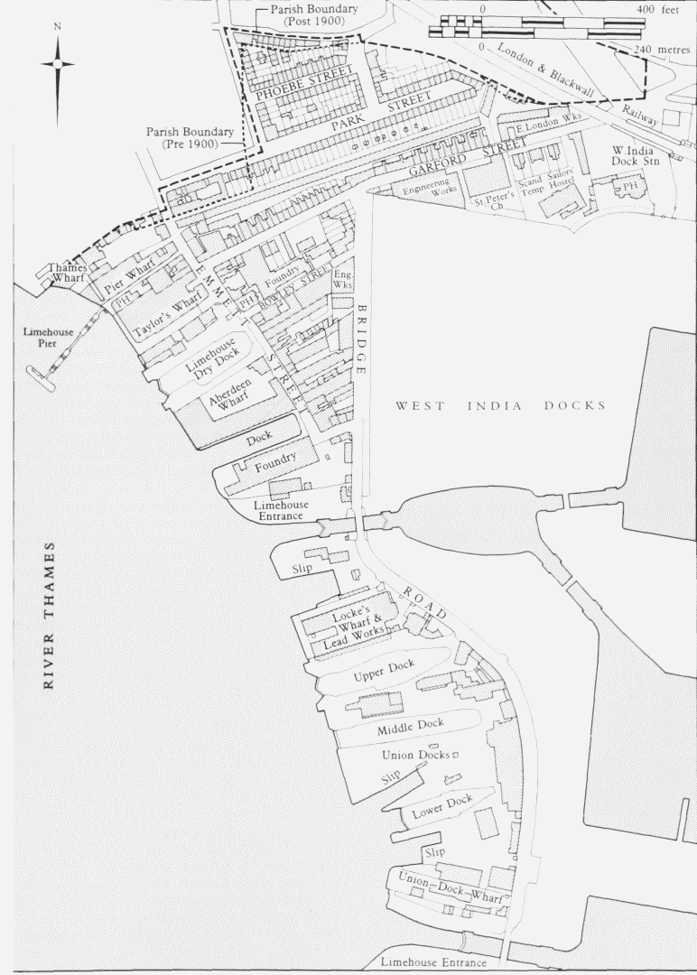
Limehouse Hole area. Based on the Ordnance Survey of 1893–5
The sail warehouse on the east side of Emmett Street was used by E. Speeding & Company, sail- and flagmakers, and Alfred Masson, a corn merchant, before being removed in 1946–7 to make way for an electricity sub-station. The west end of the covered ropewalk was incorporated into a contractor's yard until clearance in 1955–6. (fn. 22)
Limehouse Hole Stairs and Limehouse Pier
Limehouse Hole was a plying place for watermen from the seventeenth century. There were two sets of river stairs in 1687, but only those at the end of the passage that became Thames Place survived. They are prominent in John Hood's painting of Limehouse Reach in 1768 (Plate 146b). (fn. 23) In 1843 watermen attempted to recover business lost to steamboats by erecting a floating pier at Limehouse Hole Stairs. This had evidently gone by 1860, when the Thames Conservancy erected new stairs projecting on to the foreshore. (fn. 24) Representations calling for a passenger steamboat service to the locality persuaded the Conservancy Board to erect a floating pier at Limehouse Hole Stairs in 1870. The pier, a walkway on three pontoons, was designed by Stephen William Leach, the Board's engineer. (fn. 25) It was removed in 1901 for the building of Dundee Wharf. In 1905–6 the LCC constructed a pier, consisting of two lengths of lattice-girder walkway to a pontoon, as one of several river piers erected for the 'Penny Steamer' service. (fn. 26) It was removed by the PLA in 1948, but the stairs and Thames Place, though closed off in 1967, survived until 1990. (fn. 27)
The Staples's Distillery — Buchanan's Wharf Site
The riverside below Limehouse Hole Stairs was developed c1692 when Richard Staples and William Holland built a substantial malt distillery which was enlarged c1715. North of the distillery there were at least four houses, built after the land was let to Doyla Catterton, a colourmaker, in 1695. (fn. 28) Near the stairs there was a public house, perhaps known as the White Lion in the late seventeenth century, later the Chequers, and then the Horns and Chequers. (fn. 29) The Royal Oak public house stood to the east of the distillery on the road that became Emmett Street. From c1735 Ricklas Booth & Company had the distillery, ten years later it passed to Sherman Godfrey & Company and from c1767 to c1790 it was held by Isaac Lefevre and Thomas Ayre. Hood's painting of 1768 shows the Chequers and a long barnlike building beyond, perhaps the maltings (Plate 146b). (fn. 30)
Lefevre and Ayre probably rebuilt the distillery c1775–6, when they took a new lease. Their main building was a large three-storey brick block, in two divisions with timber internal construction. (fn. 31) The 'maltings' was replaced by three-storey brick warehouses, one of which was 215ft by 21ft. The warehouses were let to Joseph Bramah c1799 and used for hay-pressing, presumably with Bramah's hydraulic machinery. At approximately the same date the distillery was taken by Thomas Bowman and John Garford, oil and seed merchants, who were tenants of the northernmost windmill on Millwall. Garford later gained sole control of the premises, which became a seed-crushing mill and oilcake and seed-cake warehouse, and he acquired the former hay-pressing buildings in 1835. (fn. 32)
John Garford (c1772–1850) was a prominent figure in Poplar, active in the formation of the parish and the building of All Saints' Church. The road that ran from his wharf to the Commercial (West India Dock) Road still carries his name (see below). Until 1877 his family produced oilcake at what became Garford Wharf, with A. E. Burrell & Son using the eastern part of the premises as a paint factory from 1874. (fn. 33) The main buildings were sold to William Taylor & Company for use as a paint factory called Taylor's Wharf, (fn. 34) and the long warehouse (215ft by 21ft) was used by R. J. Hanbury for storing rice, wheat, tapioca and hops, and was known as Limehouse Wharf (Plate 42b). These wharves were combined as Venesta Wharf from 1900 to 1921 under the occupation of the Venesta Company, packing-case makers. (fn. 35) The Royal Oak public house was rebuilt in 1878 and No. 12 Emmett Street, just north of the long warehouse, was the United Brothers' beerhouse from the late nineteenth century until 1935. (fn. 36)
P. R. Buchanan & Company, tea merchants, acquired Venesta Wharf in 1921, to replace a wharf at Wapping. (fn. 37) The eighteenth-century warehouses were extended towards Thames Place in 1924 and 1928–9 with fourand six-storey blocks, and the Horns and Chequers was demolished. (fn. 38) The old warehouses and the Royal Oak were replaced in 1935–7 with six-storey brick warehouses designed by Charles Dunch & Son, architects and wharf specialists. (fn. 39) Buchanan's Wharf was severely damaged in the Blitz. (fn. 40) The south-east corner block survived, but the other buildings on the rectangular site were reinstated in 1950–2 as a six-storey warehouse, with A. J. Thomas and G. Hartley Goldsmith as architects. The building was brick with reinforced-concrete internal construction, rather than the timber and iron used in the 1935–7 buildings. It was similar in appearance to those lost; plain and bulky, with a touch of Classicism (Plate 42a). Towards the river there were full-height pilaster strips beneath a continuous cornice. The eight divisions provided more than 1,250,000 cu.ft of storage for tea and rubber. (fn. 41) Buchanan's Wharf was cleared in 1990 to make way for the Limehouse Link road.
Batson's Yard, Limehouse Hole, site plan in 1799Key: 1 House: 2 Store: 3 Antigallican Public House: 4 Sawpits: 5 Pitch-House and Boiler: 6 Kiln and Warehouse: 7 Anchor Smith
The Aberdeen Wharf Site
Gray's and Heydon's Dockyard. The riverside property latterly Aberdeen Wharf was part of the land purchased by George Margetts in 1662. Edward Gray, a Shadwell mastmaker, acquired approximately five acres of the site on a 99-year lease in 1678, soon after he had taken a contract from the Royal Navy worth £14,400. (fn. 42) Initially Gray used his land for a mast- and timber-yard, but soon began an ambitious development, wharfing the upper section of his frontage as a dockyard, with a dry dock and a large house. The building work was incomplete when he died, greatly in debt, in 1682. (fn. 43) His son, also Edward, finished the project, probably in 1684. The dry dock alone had cost about £1,000, and later in the 1680s it had to be substantially rebuilt for about £500 more. The house was a substantial one, with a belvedere on a balustraded roof-flat (Plate 146b). The yard had storehouses, a smiths' shop, cranes and smaller houses. (fn. 44)
The lower part of Gray's frontage was taken by John Heydon, a shipwright, who built another dry dock in 1686. The two dry docks were recorded in 1742 as being a single dock 198ft long, 36ft 4in. wide and 13ft 9in. deep, and a double dock 168ft long, 40ft 9in. wide and 13ft 7in. deep. (fn. 45) It is not evident that they had been enlarged since their construction. By 1687 Gray's dry dock had been let to a Mr Kerbey, perhaps John Kirby; Gray retained part of the site as a mast- and timberwharf. To build warships, Heydon made a 'lanth' or slipway in 1693–4, by which date he held both dry docks and the house. Heydon was succeeded at the yard by George Fowler, tenant from 1696–7 to 1711. (fn. 46)
Batson's Yard. This dockyard and its house were briefly in the hands of William Johnson and others in 1712–19, before passing to William Hoskins. Robert Carter took the yard in 1737, when the Gray family gave up the lease, (fn. 47) and he was building ships for the Royal Navy in the 1740s. He died in 1751 and was succeeded by his nephews, John and Robert Batson. Their yard is prominent in the painting by John Hood, who may once have been a foreman there. He shows it and the foreshore congested with Baltic timber, imported for the building of warships and East Indiamen (Plate 146b). (fn. 48) From c1770 Robert Batson (c1735–1806) had sole control of the yard. He made some improvements, building a new smiths' shop and, in 1778, a mould loft (fig. 142). He also rebuilt the north-east corner of the yard as the Antigallican public house, which survived until the 1850s. (fn. 49)
Curling, Young & Company (Limehouse Dockyard).. In 1800 Batson's yard was transferred to Cox, Curling & Company, shipbuilders, previously based at Duke Shore, Limehouse, and across the river. They enlarged the dry docks and demolished the house. (fn. 50) In 1864 the dry docks were measured at 240ft by 48ft and 240ft by 40ft. (fn. 51) The company was controlled in the early nineteenth century by Robert Curling and William Young. William Curling (c1770–1853). Jesse Curling and George Frederick Young succeeded them and from c1820 the firm was known as Curling, Young & Company (Plate 41c). They built East and West Indiamen and, from the late 1830s, large merchant steamships, all of them of timber, not iron (fig. 152). (fn. 52) The yard became known as Limehouse Dockyard, and the management as Young, Son & Magnay from about 1855, by which time at least one of the slips was covered with open-sided shedding. (fn. 53) The firm continued to build large timber ships, but this was a declining section of the shipbuilding industry.
Aberdeen Steam Wharf, Limehouse Hole, site plan in 1878. A–D Warehouses
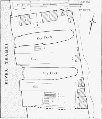
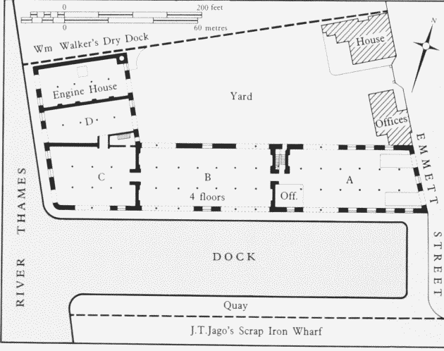
In 1865 Limehouse Dockyard was bought by the newly formed London Quays & Warehouses Company, which planned to provide wharfage and warehouses around a new dock. Buildings were cleared in early 1866, but the scheme was not implemented, probably because of the current difficulties in the financial markets. (fn. 54) Sidney Young & Company operated the lower section of the dockyard until 1874. William Walker & Company, shipbuilders, took the upper dry dock in 1869. (fn. 55) It was lengthened to 256ft, still largely timber-lined with timber gates, with new shedding on its north side. As Limehouse Dry Dock it was occupied by James Turner and others until c1901. (fn. 56)
Aberdeen Wharf. The Aberdeen Steam Navigation Company, previously established at a wharf in Wapping, acquired the lower half of Limehouse Dockyard in 1874, and by 1878 had completely redeveloped the property, with James A. McConnochie as engineer. (fn. 57) The dry dock was filled in and the site of the building slip to its south excavated as a brick-lined tidal dock about 250ft by 50ft. A four-storey block of warehouses in four divisions, with a reversed-L plan, was built on the north side of the new dock (Plate 42c; fig. 143). The architect was George Judge (c1826–1902) and the builders were H. Lee & Sons. (fn. 58) Parts of the ground storey were left open from quay to yard for transit handling. The first floors had brick arching on iron joists, girders and cylindrical castiron columns with ornamental heads. The upper storeys had timber floors on similar columns. There were timbertrussed slated roofs of about 45ft span with wrought-iron queen rods. The brick waterside elevations had a giant order of pilasters. The capacity of the warehouses was about 770,000 cu.ft, and the site had its own hydraulic power supply. Towards Emmett Street the yard was enclosed by offices and a manager's house, flanking an entrance gate. (fn. 59)
Aberdeen Steam Wharf was chiefly used for the storage of goods brought from Scotland, notably tinned salmon. (fn. 60) The wharf was extended to include the Limehouse Dry Dock site in 1901–4, by the filling of the dry dock and the erection of three four-storey warehouse divisions along the riverside, continuing the lines of the earlier buildings. The engineer was J. J. Robson and the builders were George Munday & Son. The warehouses, which had a capacity of 490,000 cu. ft, had Columbia fire-proof flooring (that is, flat concrete), above the ground storey, and timber upper floors and roof trusses, all on cast-iron columns. The faccedil;ade treatment of the earlier buildings was continued, but to the river the parapets were decorated with polychrome voussoirs. (fn. 61) A variety of tenants occupied parts of the wharf. In 1912 J. Spurling Ltd took the three 1870s warehouses alongside the tidal dock for the storage of strawboard and paper; that part of the wharf was renamed Spurling's Lower Wharf, or Lower Aberdeen Wharf. (fn. 62)
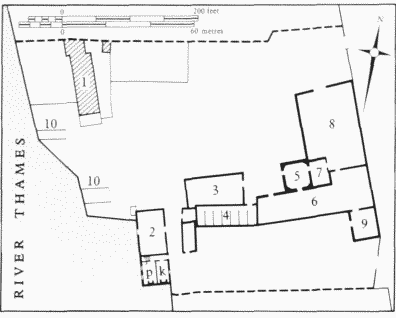
White Lead Factory, Limehouse Hole, site plan in 1787Key: 1 House: 2 Brewhouse with Parlour (p) andKitchen (k): 3 Three-storey Store with two Lofts:4 Stables: 5 Former Windmill: 6 Wash-House withDrying-Lofts: 7 Engine-Room: 8 Stackway:9 Smelting-Room: 10 Drawdocks
The wharf was badly damaged in the Blitz; the remains of the riverside warehouses were cleared in 1948–9, and the Emmett Street house and offices in 1956. (fn. 63) A singlestorey transit shed, approximately 144ft by 100ft, was erected in the yard in 1950. The quay walling was renewed in concrete to support travelling diesel-cranes and a single-storey brick Customs Office was erected at the north-west corner of the wharf. (fn. 64) In 1952 J. Spurling Ltd put a reinforced-concrete upper storey on the surviving ground floor of the division near Emmett Street, and in 1956 the firm took over the whole wharf. (fn. 65) P. Bork & Company Ltd (later P. Bork Shipping Ltd), timber agents, acquired the wharf in 1962, for the storage of veneers. (fn. 66) The remaining 1870s warehouses were demolished in 1971–2, and a single-storey transit shed was put up on the south-east corner of the wharf, with open lean-tos erected on the north and east sides of the yard. (fn. 67) Aberdeen Wharf was cleared in the late 1980s for use by contractors working on Westferry Circus and other parts of the Canary Wharf site.
The Limehouse Entrance Lock and Westferry Circus Area
The White Lead Factory and early Timber Yards. The section of riverfront occupied by the north-west quadrant of Westferry Circus has a complex history. The flood wall here was rebuilt well back from the river following the large breach in 1660 (see below). The building in 1678–84 of Edward Gray's dockyard, just to the north, made the adjoining foreland particularly useful for the laying of masts and other shipbuilding timber. It was let initially to Gray's partner William Wood, a mastmaker, then from 1698 to Philip Dyson, a Bermondsey shipwright. Dyson's house stood behind the flood wall and nearby was the Star, a timber-built public house. (fn. 68)
A section of this foreland, with a frontage of 110ft, was developed in 1717–20 by William Rice for the production of white lead. His buildings included a windmill, and there was a drawdock. In 1734 the site was sold to the London (Quaker) Lead Company, which was engaged in the mining and smelting of lead in northern England and north Wales (fig. 144). (fn. 69) By 1740 the company had wharfed the land and enlarged the whitelead factory. (fn. 70) Lead that was otherwise unmarketable was brought here by ship and used to make paint, chiefly sold in the metropolitan area. (fn. 71) The manufacture of white lead was by the 'stack' process, which had been brought to England from Venice, via Holland. The 'stack' was an enclosed building about 50ft by 40ft, in which lead plates, cast in the smelting room and then rolled, were placed in pots of vinegar and stacked several layers high over a bed of horse manure. The lead was left to corrode for a few weeks, then ground into paint powder in the windmill, which was replaced by an 'engine' in 1755–6. A brewhouse, near the river, and stables may have been added at this date. (fn. 72)
The London Lead Company vacated the premises in 1780 and they were then taken by Richard Hanks as a timber-wharf and yard. (fn. 73) The factory buildings were let to Peter Mellish in 1787 as warehousing and a part of them was occupied for a time by the East India Company as Bengal Wharf. (fn. 74) From about 1727 the south end of the white-lead site had been used by John Satchell, a timber merchant. From mid-century John Tucker, of Weymouth, had part of this frontage as a stone-wharf, presumably for Portland stone. (fn. 75) Tucker's stone-yard and Satchell's deal-yard each had a house, but no other buildings of consequence. The drawdock at the south end of this frontage was used by Obadiah Reeves, a timber merchant, from about 1768, and after 1778 he made the site a ship-breaking yard. (fn. 76)
All of these properties were compulsorily purchased for the formation of the west entrance lock to the West India Docks and the buildings were demolished, except for Hanks's house, which was dismantled in 1828, following flood damage. (fn. 77)
Emmett Street Wharf. The remainder of the whitelead factory site — north of the entrance lock and south of Emmett Street — was garden until 1835, when Curling, Young & Company took it for use as a timber-yard. (fn. 78) Following closure of their dockyard in the 1860s the site was used as a scrap-iron wharf by James Thomas Jago. (fn. 79) In the 1870s Sidney Young & Company made the property a shipwrights' and joiners' yard and put up a sawmill. (fn. 80) In 1885 the wharf was let to Thomas Smith, an ironfounder from County Durham, who named the site the Emmett Street Foundry and Wharf. Thomas Smith & Company were 'manufacturers of sashweights, columns, firebars, sanitary castings etc'. A large foundry was erected in 1889–90, and a moulding shop and store in 1898. The company was wound up in 1916. (fn. 81)
Emmett Street Wharf was purchased c1916 by William Mallinson & Company, timber merchants, who, as a wartime exigence, used it to store aeroplane timber. An open-sided shed of 18 bays, 267ft long, was erected in 1917–18 to cover the timber. It had a Belfast-truss roof on reinforced-concrete columns and an electric travelling crane on a gantry which projected over the river. Four brick timber-drying kilns were built at the east end of the wharf. The builders were Leslie & Company of Kensington Square. (fn. 82) From the early 1960s to 1984–5 the wharf was occupied by Jack Summers Ltd, timber merchants and kiln dryers. (fn. 83) The site was subsequently cleared and is now part of Westferry Circus.
Bridge Wharf. The West India Docks' Limehouse entrance lock became unusable upon the filling of the Limehouse Basin in 1927–8. In 1929 the lock and its pierheads were let to J. J. Prior Ltd, sand and ballast wharfingers and transporters, who filled the lock and wharfed the frontage with timber in 1930. No. 8 Bridge Road, a former gatekeeper's house built by the West India Dock Company in 1815, was also leased and the site was named Bridge Wharf after the redundant lock crossing. Amongst the processing structures erected in the 1930s were a tar plant-house of three steel silos, hoppers, conveyors and cranes. (fn. 84) Bridge Wharf was transferred to Merediths Ltd, timber importers, in 1962, and the wharfing was replaced with concrete-capped steel sheet-piling. (fn. 85) The site has been absorbed into Westferry Circus.
The Limehouse Slipway. The former ship-breaking yard south of the entrance lock was used by the West India Dock Company as its main site for the delivery of bricks during the building of the docks, when it contained a mortar steam engine and lime-kilns (see page 326). In 1813, when the dock company's primary building works were complete, the frontage was embanked in brick, leaving a drawdock or slipway for the repair of dockcompany lock gates and boats. The surrounding area was used as a carpenters' yard, occupied by Thomas Johnson & Son, who rebuilt the drawdock with landing stairs in 1822–3. (fn. 86) Boatbuilders' and smiths' shops were erected later in the nineteenth century. The site and its buildings were leased to Charrington, Gardner, Locket & Company in 1925, for their barge repair business. (fn. 87) The slipway was reconstructed in concrete in 1938–9 to take two barges under one roof, but the buildings were destroyed and the slipway damaged in the bombing raids of 1940–1. (fn. 88) The PLA took the site in 1962 for the repair of its own barges and John Mowlem & Company then raised a shed roof and gantries over the slipway. (fn. 89) The PLA sold the Limehouse Slipway c1972 and it was subsequently used by Robbins (Marine) as a barge- and yacht-repair yard. The site was taken for the building of Westferry Circus. (fn. 90)
The Union Wharf Site
The Breach, Poplar Gut and the Gut House. A large section of the medieval river wall below Limehouse was dramatically breached on 20 March 1660 and much of the Isle of Dogs was flooded. It was the worst breach since that of 1449, although smaller ones had occurred from time to time, and they may have become more frequent during the seventeenth century. (fn. 91) The Poplar Commissioners of Sewers repaired the damage and rebuilt other sections of defective wall, at a cost of more than £16,000, raised by the imposition on landowners of very high rates of about £24 per acre. The work was done by William Ham, Orton Brooker and George Salmon, and presumably consisted of timber piling and planking, with chalk and clay fill and buttressing. The new section of wall was set well back from the river behind unprotected foreland that came to be known simply as the Breach. (fn. 92) Most of the floodwater was drained, but approximately five acres of water remained, stretching eastwards from the Breach. This came to be called the Great Gut, or Poplar Gut. (fn. 93)
In the early 1730s William Atterbury, a butcher, built a house at the south-west corner of the Gut; this became a public house which by 1750 was known as the Gut House, although it may originally have been the Shipwright's Arms (Plate 41b). (fn. 94) In the 1790s a row of eight houses and William and John Godsell's ropeyard were built south of the Gut House, but these were removed within a decade for the building of the City Canal. (fn. 95) The Gut House was displaced by the West India Export Dock in 1806 and the establishment moved to new premises north of the City Canal west entrance lock, but these had to be demolished in 1811 for a realignment of Bridge Road. The proprietor, James Oughton, then moved slightly further south to build the City Arms public house (see page 409). (fn. 96)
The Breach Dockyard, 1707–1818. The large foreland formed by the breach of 1660 was used for laying up timber until 1707. In that year John Winter, a London shipwright, who had taken important Navy contracts, was given a 99-year lease of about four acres of the Breach south of Philip Dyson's foreland, a site more than 500ft deep, with a river frontage of c350ft. (fn. 97) Winter quickly began work on a major building project, reclaiming and wharfing the land as a shipbuilding yard. It was wartime and ships were in demand, but Winter overreached himself, found that he could not meet his debts — which were £7,360 by 1710 — and his mortgagee, Peter Pouree, foreclosed. Building work continued under Pouree until 1712, and John DeGreaves occupied the yard until 1715, when Pouree was himself declared bankrupt. (fn. 98)
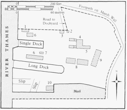
The Breach Dockyard, Limehouse Hole, site plan in 1774 Key: 1 Carpenters' Shop: 2 Watch House: 3 Coach House: 4 House and Wings: 5 Wash-House and Brew-House: 6 Sawpits: 7 Coachman's House: 8 Warehouses: 9 Mould Loft and Stable: 10 Smiths' Shop
Winter's dockyard was built with two dry docks, presumably timber lined. One was described as the 'long Dock' and was one of the longest private dry docks on the Thames (Plate 41a; fig. 145). In 1742 it was measured as a double dock 406ft long, 40ft 8in. wide and 14ft 2in. deep, although by 1864 it was only 320ft long and 37ft wide. The single dock was 140ft long, 38½ft wide and 12½ft deep. At the lower end of the yard there were one or two building slips and towards its rear were warehouses, a mould loft and, most prominently, a substantial three-storey house with full-height forward-projecting pavilion wings. There were also brick pitch-furnaces, smiths' and carpenters' shops, sawpits and a crane. (fn. 99)
In 1715 William Hoare, previously employed in the yard, became its manager. Hoare acquired the remainder of Winter's lease in 1717 and the 500-year head-lease in 1719. He died in 1740 and his son let the yard to Thomas Snellgrove, who built for the Royal Navy, as he or his family had previously done in Wapping and Deptford. (fn. 100) In 1753 the yard was sold to John Smart (c1702–77), a malt distiller. (fn. 101) Smart had the yard painted by Francis Swaine, but he did not use it for shipbuilding (Plate 41a). By 1754 he had built a distillery, served by the two windmills which he erected near the river between 1754 and 1759 (Plate 146b). He also put up a cooperage, stables, pigsties and a bacon house. (fn. 102) In 1774 Smart leased the property to James Menetone, a Wapping and Ratcliff shipwright, and cleared his buildings so that the site could again be used as a dockyard. Menetone reconstructed the smaller dry dock, probably enlarging it, and spent at least £2,000 on the premises before his death in 1786. (fn. 103) The yard was then taken by his son-inlaw Almon Hill (c1741–1808), in partnership with Robert Mellish, and they built warships and East Indiamen. From 1808 to 1818 the business was carried on by Hill's sons, Almon and James. (fn. 104)
The yard had changed little since the early eighteenth century. A storehouse had been built on the north side of the upper dry dock, probably by Menetone in the 1770s, allowing the old warehouses to become smiths' shops and stables. A foreman's house and, adjoining it, a large two-storey rigging house had also been built to the south-west of the main house. (fn. 105)
The Breach south of the dockyard was a mast- and timber-laying dock throughout the eighteenth century (Plate 41a). (fn. 106) It was partially reclaimed for the west end of the City Canal in 1802–5. The section between the canal and the dockyard was acquired by the West India Dock Company in 1805 for a projected second Limehouse entrance, but this was not built, and it remained a mast pond until 1829. There was also a timber-yard adjoining the north pierhead of the canal entrance lock. The Breach south of the lock was wharfed and developed as the Canal Iron Works in 1807–9 (see page 410). (fn. 107)
The Union Docks (Fletcher, Son & Fearnall), 1818–1925. The West India Dock Company bought the freehold of the Hills' dockyard in 1818, partly with a view to possible enlargement of its Limehouse Basin, partly to control development near the docks. In 1808–15 a road had been built along the line of the river wall of 1660, skirting the east side of the dockyard, and the company rerouted this away from its Export Dock after its acquisition of the yard. The mansion and mould loft were demolished and an extensive garden with an ornamental pond was also destroyed. (fn. 108) In 1818 the lease of the yard, with an additional plot as far north as the drawdock that became the Limehouse Slipway, was transferred to the partnership of Henry and Joseph Fletcher and William Fearnall, trading as Fletcher, Son & Fearnall. (fn. 109) The Fletcher family had been shipbuilders at Shadwell since the early eighteenth century. (fn. 110) A new house built at the north end of the dockyard c1820 was a large villa with multiple bow windows, perhaps comparable to Bridge House in appearance. John Rennie may have been its architect, through the connection with the dock company. He did prepare plans for rebuilding the upper dry dock in 1821, but when it was remade in 1824–5, it was probably not to Rennie's specifications. As measured in 1864 it was 276ft long and 48ft wide. (fn. 111) Opposition to the use of dock-company land for shipbuilding led the company to agree in 1822 to give up the freehold, but it was not actually sold to Joseph Fletcher until 1827. (fn. 112)
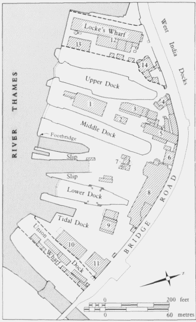
Union Docks, Limehouse Hole, with Locke's Wharf and Union Dock Wharf, site plan in 1881 Key: 1 Engineering and Fitting Shops: 2 Store: 3 Ship-wrights' Shops: 4 Offices: 5 Smiths' Forges: 6 Steam Hammer: 7 Coal-Tar Furnaces and Drying Shop: 8 Engineering Workshop, Drilling, Boring and Punching Machines: 9 Sawpits: 10 Block-and-Pulley Workshop and Mast House: 11 Sail Loft: 12 Workshops, Furnaces and Foundry: 13 Storehouse: 14 House
Fletcher. Son & Fearnall were early steamship builders, taking contracts from British and foreign governments, the East India Company and steam-navigation companies. They also repaired shipping using the West India Docks. Thomas Joseph Ditchburn (1801–70) was superintendent of the yard from 1822 to 1837 and established its reputation for steamship building. He was an innovative designer, specializing in long, fast river- and excursionvessels, some of the ships' engines for which were made nearby at the Canal Iron Works. (fn. 113) Joseph Fletcher extended the dockyard to the south in 1829–31, leasing the former mast pond and timber-yard from the dock company. (fn. 114) He solved the problem of creating the foundations for a dry dock on this unembanked frontage by sinking the hull of the Canton, an old East Indiaman, in the former mast pond, fastening it down with piles, fitting it with timber gates, and surrounding it with made ground to form an oak-lined dry dock, 220ft by 56ft. Completed by 1833, the dock was intended for steamboats, and so there were recesses in the side walls to give room around the paddles (fig. 146). Associated work included new wharf-walling, a building slip south of the dry dock, sheds, sawpits, a mastmakers' shop and a house. The Union Docks thus came to occupy virtually all of the Breach, with the entire frontage between the two Limehouse entrance locks, becoming one of the largest private yards on the Thames (Plate 147b). (fn. 115)
From the death of Joseph Fletcher in 1852, the firm was controlled by John Thompson Fletcher and Thomas Keddey Fletcher, with the latter carrying on alone from 1869 until his death in 1889. It did not make the transition from timber to iron or steel shipbuilding and so its business became predominantly repair work. In this period a sawmill with an engine house was added between the upper and middle docks, and shops for sail-, mast- and blockmakers, riggers, coopers, blacksmiths and fitters were erected to the south. (fn. 116) The lower or steamboat dry dock was slightly lengthened c1873–4. (fn. 117) The upper dry dock was enlarged in 1879–80, with Edward Charles Homer as engineer, being lengthened by approximately 50ft, to 334ft, and made 46½ft wide at its entrance, and 17ft 4in. deep at high water. It was given brick walling and a concrete bottom, but retained its timber gates behind new jetties. The middle dry dock was also enlarged in 1880, to 352ft long and 44ft 3in. wide at its entrance, and deepened by 1ft 6in. to 15ft 10in. Its timber entrance was reconstructed in brick and concrete and given an iron caisson instead of gates. The sawmill between the upper and middle docks was replaced in 1880–1 with a two-storey engineers' shop, eight bays long, with a surrounding veranda, for general marineengineering and boiler-making work. (fn. 118)
From 1889 the proprietors of the Union Docks were Reginald George Fletcher and Henry Marshall Fletcher, the former acting alone from 1896, when Fletcher, Son & Fearnall became a limited-liability company. In 1891–2 the upper slipway was filled and embanked, and a gridiron 250ft by 40ft was laid along the foreshore. The gridiron was later shortened to 130ft and moved to a position below the lower dry dock. (fn. 119) The lower dry dock was entirely rebuilt in 1897–9 with W. R. Kinipple, a drydock specialist, as consulting engineer, William Jaffrey as resident engineer, and Kirk & Randall as contractors. The hull of the Canton was removed and land was reclaimed from the river to make a dry dock 440ft long, 79ft wide (60ft at its entrance) and 24ft deep. It was built entirely of concrete, and had iron gates with air chambers for buoyancy and a jetty, 46ft long, below its entrance. There was centrifugal pumping-machinery, supplied by Gwynne & Company, in an engine house north of the dock, driven by 340hp gas engines made by Crossley Brothers Ltd of Manchester, and connected to serve the other dry docks. Travelling cranes were installed beside all three docks. (fn. 120)
Fletcher, Son & Fearnall's business increasingly became general engineering work, though the 1914–18 war brought a revival in ship repair and even some shipbuilding. This allowed some improvements at the yard in 1916–18. A large office building was erected south of the Bridge Road entrance, with Andrews & Peascod as architects, and a row of three houses for dockyard employees, Fletcher's Villas, was built near the south end of the yard by Hammond & Miles, to the designs of Frederick G. Faunch. Business declined, however, and Fletcher, Son & Fearnall Ltd was wound up in 1925. (fn. 121) For a decade the Union Docks site remained vacant. The buildings were cleared, except the new offices and Fletcher's Villas (which stood until they were demolished in 1988), and the upper and middle dry docks were filled during the mid-1930s.
Locke's Wharf and Union Dock Wharf. In 1871 the northernmost section of the Union Docks — that is, the house of c1820 with land up to the river that had been its garden — was leased to Locke, Lancaster & Company, an established firm of lead merchants that had recently become manufacturers. By 1872 F. W. May of Camberwell had built a lead-refining works on the site, which became known as Locke's Wharf, and the house became offices. The works comprised a single-storey factory with two blast-furnaces, a foundry, workshops, warehouses and a tall chimney, all used to extract lead and silver from lead ores. The buildings were extended in the 1880s and a third blast-furnace, reputedly the first mechanically charged lead blast-furnace in the country, was added in 1892. (fn. 122) Locke, Lancaster & Company retained the wharf until c1930. (fn. 123)
The southernmost section of the Union Docks, the small wharf that had been a timber-yard until 1829, was let c1880 to Lamb, Beal & Son, chain-cable makers and anchor-smiths. They named the site Union Dock Wharf and put up several sheds and workshops, removed others, and retained the wharf until the early 1920s. (fn. 124)
Cargo Fleet Wharf, the Union Dry Dock and Union Wharf. The Union Docks site was divided in 1934–5. The middle section was taken by the Cargo Fleet Iron Company (a subsidiary of the South Durham Steel & Ironworks Company) and became Cargo Fleet Wharf. This steel company, which had been at Pyrimont Wharf since 1926, had been formed at Middlesbrough by Henry Frederick Swan in 1880. By 1936 a large fabricating shop, clad in steel and corrugated-iron, had been erected by John Mowlem & Company, with a huge travellingcrane gantry adjoining. The wharf was used as a stockyard and distribution depot for steel girders shipped from Middlesbrough. A two-storey office building and a brick pattern shop and store were erected on the east side of the wharf in 1948–50. (fn. 125) The northern section of the dockyard had become Union Wharf, occupied from 1934 by J. Spurling Ltd as an open timber-and stone-yard, with two sheds erected in 1935 to house iron and steel. From c1938 Union Wharf was occupied by Goodman Price Ltd, housebreakers. (fn. 126) In the late 1940s Cargo Fleet Wharf spread north on to the Union Wharf site. The wharf's river wall was reconstructed in steel sheet-piling in 1957–8. (fn. 127)
The lower dry dock and the gridiron, slip and wharf to its south were unused from 1925 until c1940, when the Admiralty requisitioned the dry dock for wartime work. It was managed as the Union Dry Dock by R. & H. Green & Silley Weir until 1951, when it was derequisitioned. (fn. 128) In 1955–6 the Thames Dry Dock & Engineering Company, which was part of the General Lighterage (Holdings) Group, converted the dry dock into a double slipway for the building and repair of small tugs and barges, designed and built by G. Tate & Son. The slipway was of reinforced-concrete, with its deck raised on columns and beams. A twin-span steel-framed shed was erected over its inner 200ft to provide a plating shop. In 1958 the lower section of wharf was reconstructed in steel sheet-piling, but the slipway was used only until c1965 (fn. 129)
In the late 1960s Cargo Fleet Wharf and the Union Dry Dock were taken as a site for the processing of sand and gravel by various concrete and dredging companies. The fabricating shop and gantry were cleared, and the slipway was filled. Wharfing was renewed and hoppers, conveyors, cranes and gantries were erected. The northern section was taken for the building of Westferry Circus. The remainder was cleared in 1991. (fn. 130)