A History of the County of Cambridge and the Isle of Ely: Volume 10, Cheveley, Flendish, Staine and Staploe Hundreds (North-Eastern Cambridgeshire). Originally published by Victoria County History, London, 2002.
This free content was digitised by double rekeying. All rights reserved.
'Stow cum Quy', in A History of the County of Cambridge and the Isle of Ely: Volume 10, Cheveley, Flendish, Staine and Staploe Hundreds (North-Eastern Cambridgeshire), (London, 2002) pp. 230-233. British History Online https://www.british-history.ac.uk/vch/cambs/vol10/pp230-233 [accessed 24 April 2024]
STOW CUM QUY
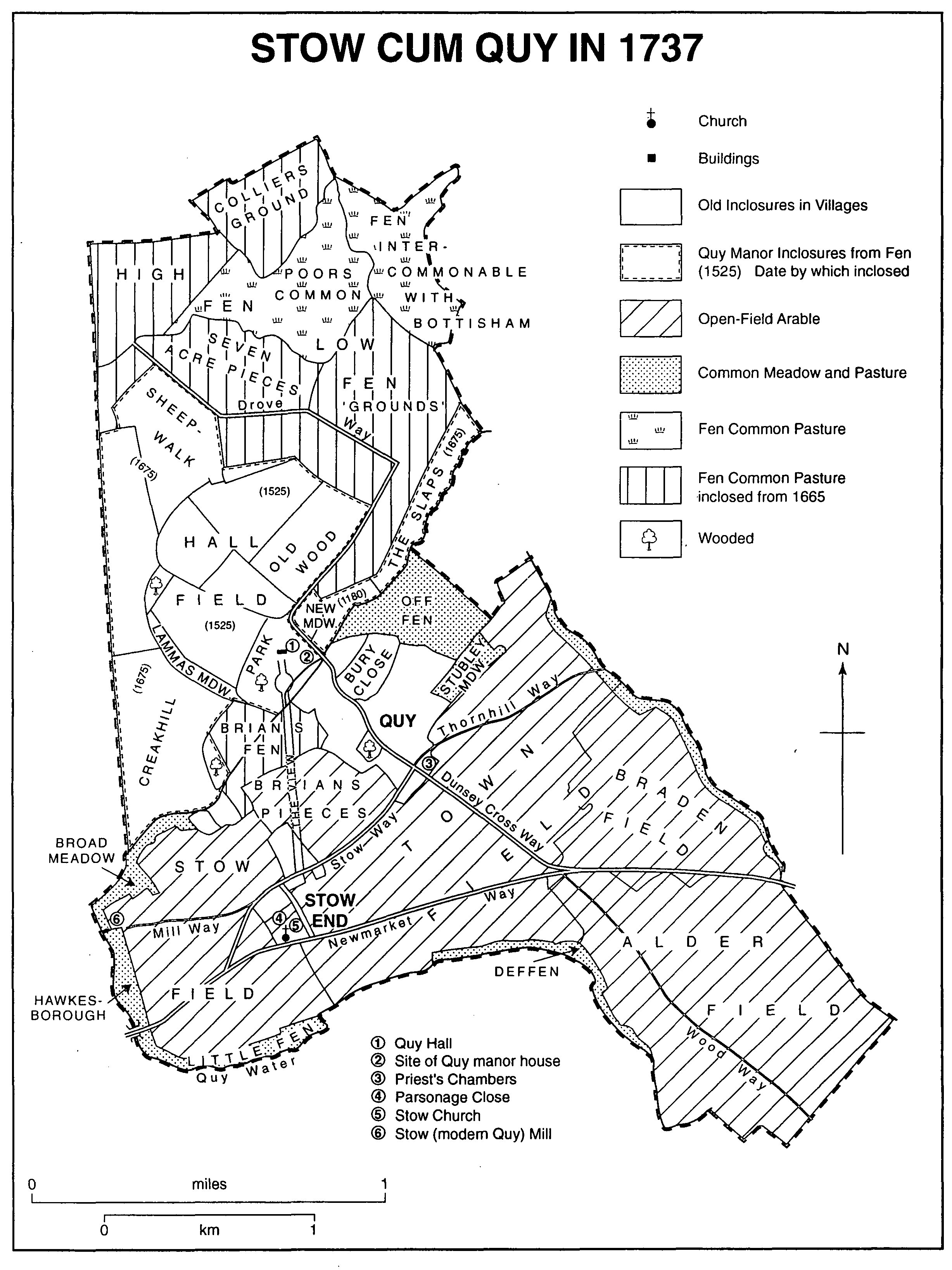
The parish, lying 7.5 km. (4½ miles) eastnorth-east of Cambridge, (fn. 1) covers 1,579 a. (fn. 2) in an approximately triangular shape. Its eastern and southern boundaries largely follow watercourses, that to the south-west running along part of Quy water. Rising near Little Wilbraham that stream turns north-east to flow across the parish north of Quy village, dividing former open-field land from fenland on the north-west. The straight line of the dykes that separate the parish from Fen Ditton to its west, principally Black ditch, probably indicates that the existing boundary there was set out only when former fenland was drained in the 17th century. (fn. 3) Following inclosure in 1839-40 (fn. 4) more than c. 50 a. of intercommonable fen at the north-east end were assigned to Bottisham parish. (fn. 5)
The Anglo-Saxon settlements of Quy, presumably named 'Cow-ey' (Cow island) from its position amid the fens, (fn. 6) and Stow were hidated together by 1066. (fn. 7) Though having separate manors, (fn. 8) they were combined as one ecclesiastical parish by the early 13th century (fn. 9) and treated administratively as a single vill by the late 13th. From the early 14th century they were regularly styled Stow cum Quy or Stow Quy. (fn. 10) In the 20th century the village was usually called locally simply Quy.
The land, mostly lying on the Lower Chalk, (fn. 11) is largely flat, the half in the north that was fenland being below 7.5 m. (35 ft.). A low ridge of gravel, rising to over 20 m. (50 ft.), runs across the south end of the parish, providing a dry route for the Cambridge-Newmarket road, a turnpike between 1745 and 1872. (fn. 12) Other gravel terraces cover the far north of the fenland. Creakhill plantation west of Quy Hall's park, 16½ a. at inclosure when there were altogether 28 a. of woodland, was probably established after 1740. (fn. 13) The southern half of the parish was used for arable farming, in open fields under a triennial rotation until inclosure in 1839. The northern part, once fen pastures, was progressively drained and inclosed between the 12th century and the early 18th. (fn. 14)
A few traces remain of human occupation from the Bronze Age onwards. (fn. 15) By 1086 the population included 17 peasant households. (fn. 16) By 1279, when at least 40, possibly c. 70, messuages or cottages were reported, there were over 60 tenants. (fn. 17) In 1327 22 people, besides two lords, paid tax, (fn. 18) and in 1377 there were 148 adults. (fn. 19) By 1524 there were only 38 taxpayers (fn. 20) and in 1563 only 31 households. (fn. 21) Pressure from an increasing population in the late 16th century is suggested by the fining of villagers c. 1590 for harbouring inmates in their cottages. (fn. 22) In 1584 newly built cottages and those put up on sites unoccupied within the last 20 years were barred from keeping more than one bullock on the common. (fn. 23) In 1660 70 residents paid a poll tax: (fn. 24) in 1664 and 1674 there were 40-45 dwellings, (fn. 25) housing 78 adults in 1676. (fn. 26) After a temporary decline in the 1720s when there were only c. 170 people in 41 families, (fn. 27) numbers recovered by up to a third by the 1760s. (fn. 28) In 1801 there were 235 people in 50 households. Growth, especially rapid until the 1820s, since the birth rate greatly exceeded the death rate from the 1780s, almost doubled the population to c. 450 by the 1840s; the number of families increased by a half. After a slight decline, (fn. 29) following some emigration, (fn. 30) numbers stabilized at 365-85 until the 1890s before dropping to c. 325 between 1900 and the 1920s. People living in military huts in the park brought a temporary rise to 527 in 1951, but the population fell to 447 in 1961 and was still only 450-60 in the 1980s. (fn. 31)
Quy village stands just beyond the northern edge of the former open fields, its older portion along a road running north-west from the Cambridge-Newmarket turnpike towards Quy Hall. That road is crossed 800 metres from the turnpike by a side road leading south-west from Lode hamlet in Bottisham parish to rejoin the turnpike near the presumed site of Stow, still called Stow End in the 20th century. (fn. 32) Stow church, almost isolated by the 19th century, still stood there in the late 20th. About 1737 it had had to its north c. 10 a. of ancient closes, perhaps once inhabited; one was called Stow close. Only two farmsteads with a few early 19th-century dependent cottages remained near the church in 1839. (fn. 33) At Quy the housing stood in 1737 amongst c. 45 a. of ancient closes. (fn. 34) Many crofts west of the street were absorbed from the 1840s into Quy Hall's park, in which earthworks from demolished farmsteads are still visible. (fn. 35)
Among the few houses surviving from before 1800 (fn. 36) is the timber-framed Park Farm east of the crossroads, built in the mid 17th century, soon afterwards enlarged eastwards, and brickcased after 1800. One timber-framed 17thcentury house still stands at Stow End. Most of the older houses, among them several early 19thcentury cottages, stand close to the crossroads, around which dwellings were concentrated in 1839, especially north-east of the street. (fn. 37) The parish then contained 12 houses, mostly farmhouses, and 63 cottages, of which 32 belonged to the Quy Hall estate. (fn. 38) In the later 19th century and the early 20th many new cottages were built, largely to standard designs provided for the estate. By 1861 there were c. 43 dwellings on and around the main street and 25 at Stow End, while 3-5 farmsteads stood elsewhere in the former open fields and fen. (fn. 39) In 1910, besides 10 houses, there were 69 cottages, including 15 at Stow End; 47 of them belonged to the Hall estate. (fn. 40) There were still only 89 houses in the parish in the 1920s. (fn. 41) In the 1930s a line of c. 13 dwellings, mostly bungalows, was built along the Stow road and the former turnpike. (fn. 42) In the early 1940s a military camp for personnel at Waterbeach airfield, including 40 huts which unlike the village were supplied with sewerage, was established in the south-east corner of the park. When squatters moved in after 1945, the rural district council took over the huts for temporary housing. The huts had been removed by the early 1960s. (fn. 43) Council houses were put up c. 1974-6 in two estates east and west of the crossroads. (fn. 44) By 1977 there were c. 50 council houses in the parish; another 63 dwellings belonged to the Hall estate, and c. 40 were owner-occupied, including many recently built at Stow End. (fn. 45)
Stow Cum Quy in 1737
Quy bridge, mentioned c. 1325 (fn. 46) and as Stow bridge in the 16th century, (fn. 47) was rebuilt in brick in 1837. (fn. 48) The Cambridge-Fordham railway line, opened in 1884, crossed the parish north of Quy water. A station was opened off Hall lane which leads north from Quy Hall. Passenger traffic ceased in 1961 and the line was closed entirely in 1963. (fn. 49) In 1959 the Stow road was realigned to bypass the village crossroads. (fn. 50) The eastern portion of the Cambridge northern bypass built in 1976-8 ends south-east of Quy mill in the south-western corner of the parish. Much of that corner was occupied by an extensive interchange with a new dual carriageway built at the same time along the southern edge of the parish, parallel to the old turnpike, to link the Cambridge and Newmarket bypasses. (fn. 51)
Quy had three or four public houses in the 19th century, (fn. 52) among them the (White) Swan, at the crossroads, in a timber-framed, possibly 17th-century, house on a brick plinth, (fn. 53) open by 1750. The Plough, recorded from the 1790s, may have been replaced by the Bush, north of the crossroads, open from 1821 (fn. 54) to 1904. The Bush's clubroom (fn. 55) was perhaps used by the friendly society with 18 members recorded c. 1815. (fn. 56) The Prince Albert opened in the 1840s on the turnpike (fn. 57) was still open in 1990, as were the White Swan and the Wheatsheaf at Stow End, (fn. 58) recorded from 1886. (fn. 59)
The village feast, traditionally celebrated on two days in Rogation week, (fn. 60) was held until the 1950s. In the 1920s showmen's stalls were set up, obstructing the customary cricket matches, on the 3-a. recreation ground (fn. 61) east of the crossroads, which had been allotted to the parish in 1840 under the inclosure Act. (fn. 62) Village cricket and football clubs played there into the 1980s. A bowls club used a ground provided from 1935 by the Francises of Quy Hall in their park, (fn. 63) previously opened to villagers on only one day a year. (fn. 64) In 1920 T. M. Francis had given a prefabricated Army hut, put up by the crossroads, as a village hall. It remained in use by the Women's Institute, started in 1919, and for other village entertainments (fn. 65) until 1981, when it was transferred to Morley Engineering for offices. The former school then became the village hall. (fn. 66)
After 1840 the remaining intercommonable fen, c. 70 a. at the north end of the parish, not affected by the inclosure, was left nominally in the ownership of the three intercommoning parishes; (fn. 67) the poor could continue to cut turf for fuel there. In the 1860s the new lord, Clement Francis, asserted sole sporting and mineral rights over it as supposed manorial waste, suing farmers who shot there. (fn. 68) In 1867 Francis's contractor for digging coprolites there was deterred by large and orderly demonstrations of labourers from Horningsea, who levelled the diggings. In 1869 labourers tried to dig the coprolites themselves. (fn. 69) By 1900 rights of turbary were no longer exercised, and the derelict common fen was subject to poaching until the Second World War, when it was let for grazing. In 1953 the tenant ploughed up all but 5 a. Vigorous local agitation led to a Scheme of 1959 vesting the fen in trustees for the three interested parishes and the Cambridgeshire Naturalists' Trust, to be preserved as an open space for recreation and as a surviving specimen of fenland, with botanically interesting grassland. The grassland was reseeded in the late 1950s, (fn. 70) and, after overgrazing, in the late 1980s. (fn. 71)
The non-juror Jeremy Collier, opponent of Restoration comedy, born in the parish in 1650, (fn. 72) is commemorated in the church and by a modern street name.