A History of the County of Cambridge and the Isle of Ely: Volume 10, Cheveley, Flendish, Staine and Staploe Hundreds (North-Eastern Cambridgeshire). Originally published by Victoria County History, London, 2002.
This free content was digitised by double rekeying. All rights reserved.
A F Wareham, A P M Wright, 'Ashley cum Silverley', in A History of the County of Cambridge and the Isle of Ely: Volume 10, Cheveley, Flendish, Staine and Staploe Hundreds (North-Eastern Cambridgeshire)(London, 2002), British History Online https://www.british-history.ac.uk/vch/cambs/vol10/pp29-33 [accessed 30 April 2025].
A F Wareham, A P M Wright, 'Ashley cum Silverley', in A History of the County of Cambridge and the Isle of Ely: Volume 10, Cheveley, Flendish, Staine and Staploe Hundreds (North-Eastern Cambridgeshire)(London, 2002), British History Online, accessed April 30, 2025, https://www.british-history.ac.uk/vch/cambs/vol10/pp29-33.
A F Wareham, A P M Wright. "Ashley cum Silverley". A History of the County of Cambridge and the Isle of Ely: Volume 10, Cheveley, Flendish, Staine and Staploe Hundreds (North-Eastern Cambridgeshire). (London, 2002), British History Online. Web. 30 April 2025. https://www.british-history.ac.uk/vch/cambs/vol10/pp29-33.
ASHLEY CUM SILVERLEY
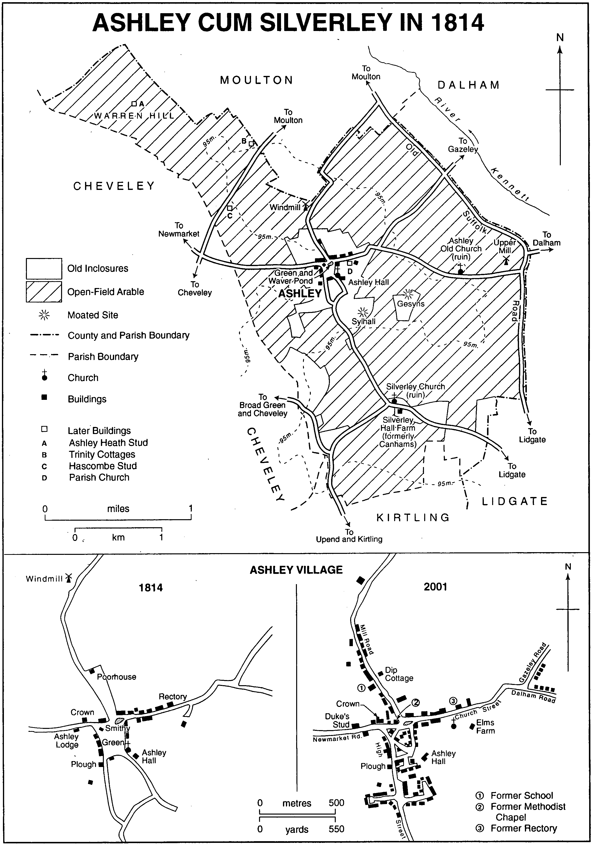
Ashley cum Silverley, usually called Ashley, is on the Suffolk border 6 km. (3¾ miles) ESE. of Newmarket. (fn. 1) Its two ancient parishes have long been united and still longer associated. The manors were owned and assessed for tax together in 1066, (fn. 2) passed to one Norman overlord, and were reunited in the ownership of the Hospitallers in the 13th century. (fn. 3) By 1300 they were economically integrated, (fn. 4) and in 1286 were fined together as the township of Silverley with Ashley, (fn. 5) Silverley having always been the larger. (fn. 6) The Hospitallers' manor house, however, was in Ashley, (fn. 7) and in 1299 the prior successfully claimed that Silverley was a hamlet of Ashley and with it formed one township and one tithing. (fn. 8) Taxes in the 14th century were laid on 'Ashley with Silverley'. (fn. 9) The ecclesiastical parishes were united c. 1550. (fn. 10)
The modern parish covers 900 ha. (2,225 a.). (fn. 11) Its boundaries on the north, west, and south conform to field boundaries. That on the east follows Old Suffolk Road, part of which connects Dalham and Moulton (both Suff.); south of the Ashley-Dalham road it was a through route in 1814 but later fell into disuse. (fn. 12) The boundary with Moulton north-west of Ashley Heath stud was straightened in 1993. (fn. 13) The line dividing Silverley on the west from Ashley on the east is uncertain in detail, though its general course lay east of the modern village, between the abandoned moated sites of two medieval manor houses, and east of Silverley Hall Farm. (fn. 14) Its line was apparently still known in 1791, when it was possible to assign precise acreages of the principal estate in the parish to Ashley and to Silverley. (fn. 15) In 1279 Silverley had three times the arable acreage of Ashley (1,382 a. against 433 a.). (fn. 16)
Ashley lies at the north-east end of a ridge which forms the watershed between tributaries of the Cam and Stour. The end of the ridge makes a flat-topped plateau above 95 m. (312 ft.) in the centre of the parish. On the east and north the land falls steeply into the Kennett valley, with the parish and county boundary lying part way down the slope. The valley bottom is in the Suffolk parishes of Lidgate, Dalham, and Moulton. The lowest point in Ashley is 55 m. (180 ft.). To the north-west the land shelves more gently from the plateau to c. 85 m. (279 ft.) on Warren Hill, a spur of the main ridge whose lower slopes are in Moulton and Cheveley. Below 90 m. (295 ft.) to the east and north the Upper Chalk underlies a dry flinty soil. Above 90 m. the Chalk is capped by boulder clay with poorly drained and heavy soils. (fn. 17) Streams descending eastwards to the Kennett have either dried up or been straightened as drainage ditches. Waver pond at the main crossroads in Ashley village is the largest of several on the plateau. It was often neglected in the 20th century. (fn. 18)
The heath on Warren Hill had been reduced by assarting to 60 a. of common pasture in 1279, (fn. 19) and survived as 100 a. of open sheepwalk until inclosure in 1814. (fn. 20) In the 1560s the manor court passed bylaws to prevent residents of neighbouring parishes from taking furze and thorns there. (fn. 21) During the agricultural depression of the 1880s the former heath, by then ploughed up, reverted briefly to rough grazing. (fn. 22)
The boulder clay was wooded in Anglo-Saxon times, when both parish names referred to woodland vegetation. (fn. 23) By the 11th century most of it had been cleared: the private manorial woods were small in 1086 (fn. 24) and covered only 9 a. in 1279. (fn. 25) They and other woods recorded in the 13th century were mostly in the centre of the parish. (fn. 26) In the 1340s Ashley manor had coppice woods of ash and oak. (fn. 27) In the mid 16th century the main estate, which had united Ashley manor with other property, had perhaps 30 a. of coppiced underwood of oak, ash, and sallow, of which half was being cleared in 1548, besides several hundred mature trees in three or four small groves. The trees in two closes were customarily cropped and shredded by the tenant for firewood and fencing. (fn. 28) No ancient coppices survived in 2001. Game coverts were planted on the heath before 1820 (fn. 29) and remained in the 1990s. Cropley park in Lidgate extended into the south-east corner of Ashley from the 13th century to the 19th. (fn. 30)
Ashley Cum Silverley in 1814
The minor roads linking Ashley with its neighbours in Cambridgeshire and Suffolk were unaltered at inclosure in 1814. (fn. 31) The most important led to Newmarket and was called Portway or Marketway in the 13th century. (fn. 32)
Both parishes were small and late settled: Silverley had only 22 or 23 families in 1086, Ashley perhaps half as many. (fn. 33) Taxes were paid in 1327 by 16 people, (fn. 34) among the smallest numbers in the county. There were 116 adult taxpayers in 1377. (fn. 35) The 120 communicants in 1603 (fn. 36) indicate a population of c. 160. Between 1700 and 1750 there was a small excess of baptisms over burials every year, averaging 2.0. The increase then became more rapid, despite an epidemic in 1763: the average annual surplus 1750- 1800 was 4.5, and was growing from the 1780s. The population stood at 272 in 1801; it rose almost without pause to 562 in 1871, with net out-migration 1801-41 taking away only half the natural increase. It fell back in the 1870s and 1880s but rose again to 584 in 1901. In the 20th century numbers fell slowly at first and then stabilized after 1945 between 450 and 500. (fn. 37)
Woodland clearance in Anglo-Saxon times produced small scattered settlements. The parish churches presumably stood at 10th- or 11th-century manorial sites: Silverley on the Chalk by a stream feeding the Kennett, Ashley at the junction of Chalk and clay. Thirteenthcentury field-names attest to other settlements by then abandoned: 'Stonley' in the north-east; (fn. 38) 'Wicham' west of the later village; (fn. 39) and 'Eldeappelton' unlocated in Silverley. (fn. 40) They were not necessarily occupied all at the same time: 'Wicham' is probably a name coined early in the Anglo-Saxon period for a settlement near a Romano-British site, (fn. 41) whereas the others, including the parish names, are of types thought to be later.
Clearance and rising population at first added to the dispersed pattern. By the 13th century both manor houses had moved to moated sites on the plateau. (fn. 42) At the lost 'Hunts green' (apparently near Silverley church) there were at least six houses, (fn. 43) but three other dwellings in the parish each stood isolated between arable land on both sides. (fn. 44) In Ashley there were two houses, not next to each other, by the DalhamNewmarket road. (fn. 45)
Settlement was concentrated on the site of the modern village, around Wood green and Waver pond, before 1300. In its final stages the shift may have been hastened by the Hospitallers as lords of the manor and owners of a chapel on the green. The green apparently lay in Silverley, since two villeins of that manor had cottages there c. 1240, (fn. 46) but the village came to be called Ashley, probably because the Hospitaller manor had that name. In the 13th century two other groups of four and seven cottages stood near the green, the larger group including the rector of Silverley's house. (fn. 47) Several cottages and arable strips near by were said to be 'in the township of Ashley in [or 'of'] the fee of Silverley'; (fn. 48) the phrase may have meant that Ashley village lay in Silverley township, or simply that Silverley was one of two fees in the united township. The house in Silverley parish which in 1386 stood between other houses on either side was probably at the green. (fn. 49)
The creation of a village at Wood green involved the abandonment elsewhere of crofts which were then ploughed up: in the later 13th century there was arable land in 'Addecroft', (fn. 50) 'Banecroft', (fn. 51) 'Clippescroft', (fn. 52) 'Grescroft', (fn. 53) 'Mannescroft', (fn. 54) 'Maugerscroft', (fn. 55) 'Sandrescroft', (fn. 56) 'Hunerestretecroft', (fn. 57) 'Netherstretecroft', (fn. 58) 'Wolverescroft', (fn. 59) and the crofts formerly of Gerin (fn. 60) and Peter of Coventry. (fn. 61) All of them were evidently incorporated into adjoining fields and their names fell into disuse. At least some of the names were derived from the names of their former owners. Although it is not certain that all the owners had lived in houses fronting the crofts, there was another house in the parish in 1442, Goystons, which bore the same name as the croft which backed on to it and presumably derived from a contemporary or earlier owner. (fn. 62)
The name Wood green was replaced by Ashley green in the 17th century, (fn. 63) and the green itself survived until 1814. The cottages and farms of the village stood in irregular crofts around its perimeter and along the roads to Newmarket, Moulton (Mill Road), Dalham (Church Street), and Silverley (High Street). (fn. 64) About 1670 there were c. 40 dwellings in the parish as a whole. (fn. 65) In 2001 no more than half a dozen houses built before 1700 survived. In 1801 there were still only 38 houses, though several were subdivided. (fn. 66) The central part of the green, 1½ a., was inclosed in 1814 and divided among 16 owners of cottage property in the parish. (fn. 67) Later in the century most of the allotments and other land north of the green were built over with cottages. (fn. 68) The loss of the green-as a writer complained c. 1908- destroyed 'the old-world appearance of the village', (fn. 69) and produced a jumble of houses standing at odd angles, like a squatter settlement. By the late 20th century that in turn had come to be regarded as picturesque. (fn. 70)
The total number of houses grew from 38 in 1801 to 100 by 1851 but not again until the 1890s, reaching 129 in 1901, and again very little before 1945. Many older cottages were condemned and demolished in the 1930s. There was a further increase after 1945 to 219 in 1991. (fn. 71) Much new building was of council houses: 30 were finished before 1939 and another 50, including some prefabs, between 1945 and 1961, (fn. 72) of which 14 stood at the fork of the Dalham and Gazeley roads, 16 on Mill Road, and the rest at Silverley Way and Silhalls Close off High Street. The first group was outside the village, the others on its periphery. Most of the post-war prefabs in Silverley Way were pulled down in the later 1980s and replaced by sheltered housing for the elderly and housing association homes for renting. (fn. 73) Twentieth-century private building was mostly of individual bungalows and houses or semi-detached pairs, (fn. 74) with one estate of 11 houses south of the green. The local authority's policy for the village, restated in 1991, was for 'infill only'. (fn. 75)
At Silverley there was only a single farm in 1752, (fn. 76) with a few cottages added in the 19th century. On the heath half a dozen cottages were put up after inclosure, and there was another at the Upper mill on the Dalham road until the mid 20th century. (fn. 77)
The village had two public houses by 1764: the Crown on Newmarket Road and the Plough on High Street. Both remained open in 1991. (fn. 78) The Plough was a private house for a time in the 1970s before reopening with a restaurant. (fn. 79) As the Old Plough it went further up market in the 1980s and was much frequented by racegoers, trainers, and breeders. (fn. 80)
There was no village Feast in 1753 (fn. 81) and only limited social activities in the 19th century. A cricket club was started in 1836, (fn. 82) and in the 1880s the school was used for concerts and other events. Dances held there in the 1920s were stopped because of vandalism. (fn. 83) The church provided a reading room in an iron shed in the early 20th century, (fn. 84) and in 1961 the British Legion hall behind the Plough was used by several groups. (fn. 85) Both buildings had gone by 1991. In the early 1960s allotments south of Silverley Way were converted into playing fields with a pavilion. (fn. 86)
The village's wider links were as much with Suffolk as Cambridgeshire. Richer farmers in the 16th and 17th centuries often owned land in Suffolk parishes. (fn. 87) The village carriers in the late 19th century ran to Newmarket and Bury St. Edmunds. (fn. 88) Out of 94 male household heads in 1861, 54 had been born in the parish, 24 in Suffolk, and only 13 elsewhere in Cambridgeshire, of whom all but 3 were from the nearest parishes of Cheveley, Woodditton, and Kirtling. (fn. 89)
Although the Kirtling and Cheveley estates had most of the land in Ashley, (fn. 90) they did not own many cottages (fn. 91) and took a smaller part in parish life than in Kirtling and Cheveley. The aristocratic owners of those estates, respectively the Norths and the dukes of Rutland, did not try to act as squires of Ashley, but they sometimes co-operated, as in 1844 when they subscribed £500 and £200 towards the cost of the new parish church; the foundation stone was laid by the duke's son Charles Manners, marquess of Granby, in the absence of the marquess of Bute, husband of the North heiress and donor of the site. (fn. 92) The influence of the Norths, however, was evident in the timing and manner of parliamentary inclosure. The Act of 1806, earlier than in any adjoining parish, covered both Kirtling and Ashley (fn. 93) and passed through the House of Lords between a Friday and the following Thursday. (fn. 94)