A History of the County of Cambridge and the Isle of Ely: Volume 10, Cheveley, Flendish, Staine and Staploe Hundreds (North-Eastern Cambridgeshire). Originally published by Victoria County History, London, 2002.
This free content was digitised by double rekeying. All rights reserved.
'Snailwell', in A History of the County of Cambridge and the Isle of Ely: Volume 10, Cheveley, Flendish, Staine and Staploe Hundreds (North-Eastern Cambridgeshire), (London, 2002) pp. 475-479. British History Online https://www.british-history.ac.uk/vch/cambs/vol10/pp475-479 [accessed 18 April 2024]
SNAILWELL
The small parish of Snailwell, (fn. 1) possibly named after an Old English word meaning either sluggish stream, or snails' spring, lies north-east of Newmarket (Suff.), and its area has remained 2,034 a. (823 ha.) from 1804 until 2001. (fn. 2) In 1992 there was a minor realignment of the boundary between Snailwell parish and Newmarket along the Snailwell Short Road and Snailwell Belt. (fn. 3) It lies in a peninsula of the county projecting eastwards into Suffolk, and is approximately rectangular in shape, being aligned towards the north-west, with its western and southern boundaries marking the county borders. In 1801 the principal landowner transferred 2 a. from Snailwell parish to Chippenham to straighten the former's eastern parish boundary. (fn. 4) A spring, perhaps the eponymous Snail well, in the north-west of the parish is the source of the river Snail which flows on a north-easterly course for 1.5 km.; its tributaries form the curving northern parish boundary. Around the spring and river there are alluvium and river gravel deposits overlying Middle Chalk. (fn. 5) A 60-m. ridge forms the southern parish boundary; to the north-west its escarpment falls within 1/3 km. to 40 m., after which the land slopes gently downwards for a further 1 1/5 km. before briefly rising to a 30-m. ridge. The terrain in the north-west of the parish is almost level. Brown sandy gravel to a depth of 0.80–0.90 m. overlies a chalky silt up to 9 m. deep, which lies on Middle Chalk. (fn. 6) From the Middle Ages until the late 20th century the parish has comprised two-thirds arable in the centre, heathland to the south, and fenland and pasture to the north and north-west. (fn. 7) The areas between the river Snail and its tributaries were subject to flooding in the late 19th and early 20th centuries. (fn. 8)
During the Bronze Age the escarpment was cleared of woodland, juniper, and thorn bushes with grazing creating the heathland, where the earliest evidence of settlement has been found. (fn. 9) Ten barrows close to the ancient Icknield way, discovered in 1879, were levelled in 1941 to make way for the airfield. (fn. 10) The earliest barrow dates from the Beaker period, and the latest with 13 cremations from the late Bronze Age, or early Iron Age. (fn. 11) In 1879 a cremation urn and 19 skeletons were uncovered during work on Exning road. (fn. 12) Objects of a possibly 'Catuvellaunian' type, discovered in 1952 at the angle of the Chippenham Road and the village Street, were presented to the Cambridge Museum of Archaeology. (fn. 13) In the late 20th century a Roman cremation burial was discovered 500 m. to the west of the church, (fn. 14) while in 1995–6 pieces of Roman pottery were found in the gardens of houses along the road called Roman Way. (fn. 15)
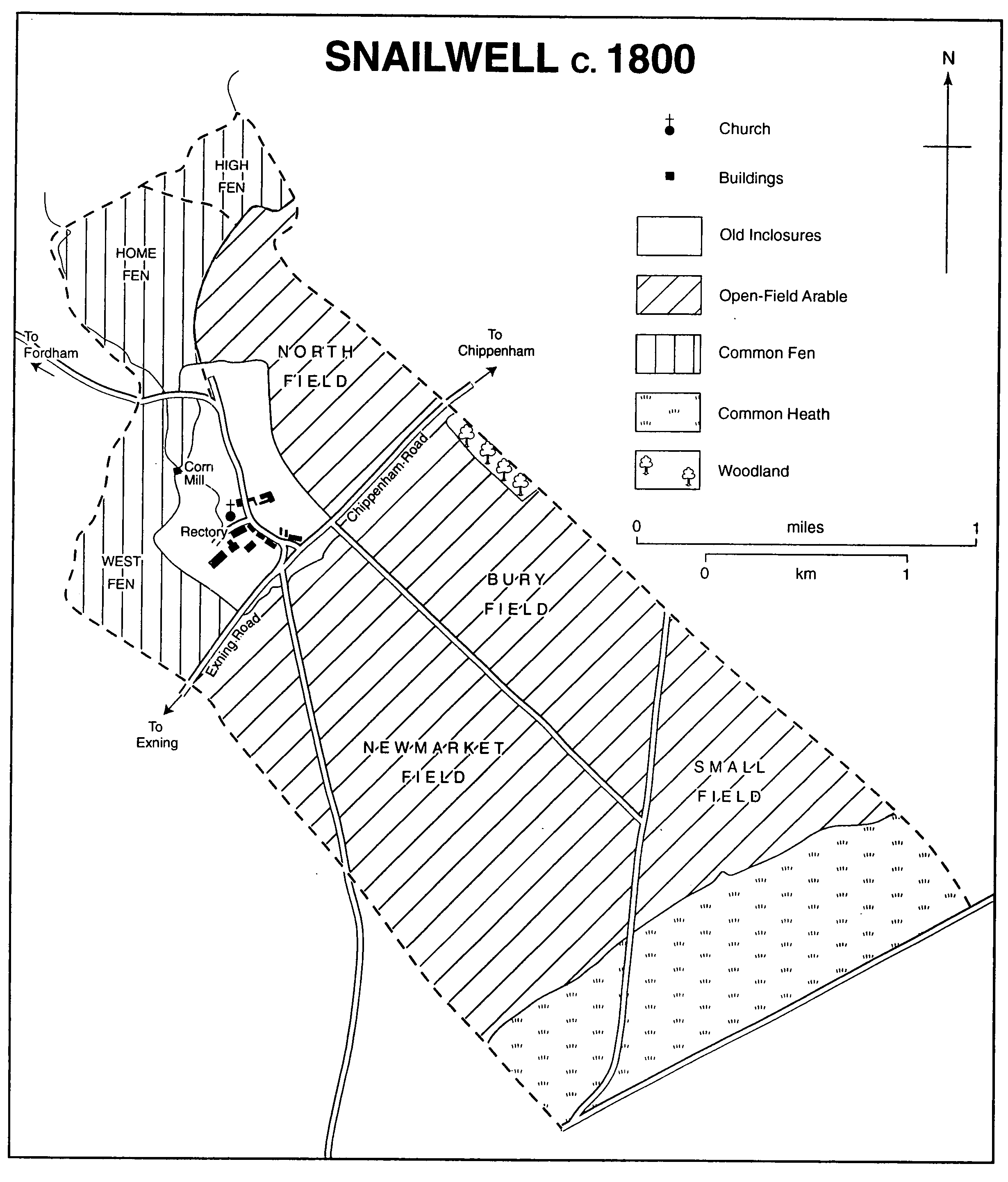
Snailwell c.1800
In 1086 18 peasants were reported in the parish, and in 1279 c. 52 landholders. (fn. 16) In 1327 there were only 27 taxpayers. (fn. 17) By 1377 the population had fallen to 105 adults. (fn. 18) There were 26 households in the parish in 1525 and 1664, and 29 in 1674. (fn. 19) Between 1801 and 1851 the population rose from 200 to 323 persons, but between 1861 and 1871 it declined from 257 to 226, before stabilizing at around 186 from 1881 to 1901. (fn. 20) In 1911 and 1921 there were around 207 people, and between 1931 and 1961 the population stood at c. 190. (fn. 21) There were 176 inhabitants in 1971 and 1981, (fn. 22) and 165 in 1991. (fn. 23)
The principal communications have always been by road: the road from Newmarket to Bury St. Edmunds (Suff.) which ran along Snailwell's southern boundary may have been made a regular Roman road, following the line of the Icknield way. (fn. 24) A major road in 1604, it was a turnpike between 1814 and 1871, and was presumably straightened by the turnpike commissioners, with a turnpike lodge being occupied at least in 1841 and 1910. (fn. 25) The Norwich road, important in 1604 and a turnpike between the 1760s and 1865, branched off the Bury road at the south-west corner of the parish and then ran north-eastwards through its southern section. (fn. 26) A road, perhaps of Roman origin, running across the parish from Exning northeastwards to Chippenham, and another running from Newmarket north and north-west to Fordham, straightened in 1806, crossed at a junction south-west of the village, and that section of the road from Exning to the junction was given the name Snailwell Short Road in 1994. (fn. 27) In 1604, at the north-western parish boundary where the Fordham road crossed the Snail, there was a bridge, named Snailwell bridge in 1659. (fn. 28) Its masonry was in good repair in 1821, but in 1996 a weight restriction of 7.5 tonnes was imposed upon traffic using it. (fn. 29) In the 19th century and probably before, Fordham and Newmarket roads were frequently used by farmers from Fordham, Isleham, and Soham to transport produce to Newmarket, (fn. 30) and the Ely to Newmarket omnibus which passed through the parish in 1845 probably used the same route. (fn. 31) The Green road (formerly Ashley road until 1805) ran from the Chippenham road south-eastwards through the centre of the parish to the former Bury turnpike, and footpaths indicate that it once led to Ashley and Cheveley villages, to the south-east. (fn. 32) It may have been used for driving sheep to the heathland. The development of gallops on the heathland c. 1882–1910, however, cut Green road short at its junction with Chippenham Park drive, and in the late 20th century it was a bridleway. (fn. 33) Between 1712 and 1801, an owner of Chippenham manor made Chippenham Park drive, or Coach road, which ran in a southwards direction through the southern section of Snailwell parish. (fn. 34) It was closed during the Second World War, and was not reopened thereafter. (fn. 35) The High Lodge built c. 1890–1910 at the entrance of the drive in the south-west corner of Snailwell parish served as the guardroom of Snailwell airfield in 1941–6, and in the 1990s housed Jockey Club employees. (fn. 36)
The modern development of Snailwell's communications has been determined by its proximity to Newmarket: in 1854 the Newmarket to Ely railway line running north-eastwards along the western parish boundary was completed. (fn. 37) In 1879 the Cambridge to Newmarket line was extended eastwards to Bury St. Edmunds running through the southern section of the parish. (fn. 38) Snailwell triangular junction constructed in 1889 in the south-west corner of the parish provided a more direct route from the East Anglian ports to the north, cutting out Newmarket and Cambridge, and was still much used in 1938. (fn. 39) By 1955, however, the section of railway which ran directly out of Newmarket northwards had been dismantled, and in 1965 diesel services between Ely and Newmarket were withdrawn. (fn. 40) Between 1972 and 1975 a section of the Newmarket bypass was built on a flyover running parallel to the Newmarket-Bury St. Edmunds railway line, (fn. 41) replacing the old turnpike as the principal road to Bury St. Edmunds. Access by public transport from Snailwell to Newmarket became increasingly difficult in the late 20th century, with a thriceweekly bus service of 1961 being reduced by 1996 to one on Saturdays. (fn. 42) The parish's inhabitants may not have been that affected, however, as in 1991 of the 75 households, 69 had cars, with two thirds having two or more. (fn. 43)
There was no significant ancient woodland by the late 11th century, and the only natural woodland in 1834 was Snailwell belt standing on the southern 60-m. ridge, covering 36 a., but much reduced in the 20th century. (fn. 44) In 1791 the parish church was surrounded by horse-chestnuts, which in the 1980s also lined the banks of the Snail along with willows. (fn. 45) Trees were planted along Chippenham Park drive by 1842, and between 1889 and 1902 others were planted along the eastern parish boundary from Jerusalem wood to Foxburrow plantation. (fn. 46) In 1961 diseased elms which lined the roads into the village were destroyed, but in 1989 conservation measures were taken to protect trees and hedges along Green lane, while pines and firs edged the fields during the 1980s and 1990s. (fn. 47)
In the Middle Ages there were five open fields, but between 1560 and 1684 around one fifth of that acreage was inclosed, and after the inclosure award of 1806 arable was concentrated in three fields to the south and north of the village. (fn. 48) The main burden of medieval rents and labour services fell upon the villeins, and few freeholds were larger than a yardland. (fn. 49) During the 16th and 17th century inclosure small peasant holdings were combined to create much larger holdings, (fn. 50) and from the late 18th century until the late 19th virtually the entire acreage of the parish, apart from the glebe, was divided between two farms owned by the principal landowner. (fn. 51)
Snailwell fen, bordering upon the northern tributary of the Snail, comprised 300 a. in 1560 (fn. 52) but both the larger part of it, and also West fen, bordering upon the western tributary of the Snail, were drained in the 19th and early 20th centuries, (fn. 53) and only 33 a. in the northern tip of the parish retained its vegetation in 1996. (fn. 54)
Between 1560 and 1684 93 a. of arable bordering upon the heathland reverted to heath, (fn. 55) being used as sheepwalk during the late 18th century and the 19th. (fn. 56) After c. 1882, when the Jockey Club of Newmarket leased and then purchased 421 a. on the Limekilns from the principal landowner, (fn. 57) it was used for equestrian training. (fn. 58) Snailwell Stud was established on the glebe, south-west of the village, between 1895 and 1910, (fn. 59) and from 1946 it has been a public stud of national importance. (fn. 60) Its most famous stallion Chamossaire (1943–65), whose offspring won prizes totalling around £336,000, was commemorated in 1965 by a life-size bronze statue made by John Skeating, (fn. 61) which stands where the Newmarket Road enters the village. Around a third of Snailwell's acreage was used for activities related to horse racing during the 1980s and 1990s. (fn. 62)
In 1684 Charles II's Lifeguards were billeted at Snailwell when the regiment was based at Newmarket. (fn. 63) From March 1941 to October 1946 a grass airfield was established north of the Bury St. Edmunds railway line. (fn. 64) It was used mainly by the American Air Force, but the R.A.F., including 302 Polish squadron, and the Royal Belgian Air Force also operated from it. Hangars and buildings were constructed along Chippenham Park drive. (fn. 65) Parts of the concrete perimeter track, with air-raid shelters and other underground facilities, were well preserved in 1996, (fn. 66) and veteran airmen from the United States returned to the parish in 1995. (fn. 67)
The village itself has probably stood at least since the 11th century in its present position nestling below the 30-m. ridge in the north-west corner of the parish. Church Lane (formerly street) runs eastwards from the Snailwell spring to a junction with the Street running northwards to the Fordham Road. (fn. 68) The lower green at the junction of those roads marked the centre of the village until at least the early 19th century. The church dates from the 11th century, (fn. 69) and there is 12th-century masonry at the former Old Rectory. Otherwise the village's oldest surviving dwellings, dating from the late 16th and 17th centuries, are Church Farm, its tithe barn, and two of its tied cottages. (fn. 70) Between 1805 and 1842 cottages for farm workers were built along the Chippenham Road at the southern end of the Street. (fn. 71) Three cottages, outbuildings, and the stable of Church Farm date from the 19th century, while much of Manor Farm was rebuilt in 1850. (fn. 72) In 1883 eight new brick cottages between Manor Farm and the school replaced earlier buildings. (fn. 73) During the late 19th century, apart from the old manor house, the Old Rectory, and two farmhouses, the rest of the 42 dwellings were farm workers' cottages. (fn. 74) By 1910 the number of dwellings had fallen to 31, with 29 being owned by the principal landowner and two by the rector. (fn. 75) The Chippenham Park Estate Company, formed c. 1932 by Lt.-Col. G. P. Tharp (d. 1933), was still the principal houseowner in the village in 1995, when there was a long waiting list for its tenancies. (fn. 76)
The estate's control of the village housing was reduced and the village layout altered in 1951–2, when Newmarket Rural District Council built 16 council houses, 12 of them bungalows, at the angle between the Street and Chippenham Road. That angular section of road was renamed Roman Way after a chieftain's burial was discovered. (fn. 77) The development changed the physical balance of the village, with the top green, renamed in 1994 the Green, in front of Roman Way replacing the lower green as its focus. (fn. 78) The council houses which were not sold in the 1980s were thereafter managed by Hereward Housing Association. (fn. 79)
Outside the village, two further houses, at Philadelphia, and Small (or Lower) farms, were built after 1805, and were divided into tenements between 1842 and 1910. (fn. 80) Philadelphia farm was demolished in 1941, and Lower farm has not been inhabited in the late 20th century. (fn. 81) In 1991 there were 22 detached houses, 44 semidetached ones, 11 terraces, one purpose-built flat attached to the old rectory, and two other residences. (fn. 82) The Chippenham Park Estate has not allowed infilling. In the 20th century the light yellow brick characteristic of the area was used for most buildings.
The village had a public house in 1670 and 1704. (fn. 83) The George and Dragon was first recorded in 1834, and has stood on its present site since 1842. (fn. 84) In the early 1850s it accommodated an annual dinner attended by gentlemen from Snailwell, Newmarket, and neighbouring parishes. (fn. 85) Inquests were held there between 1861 and 1894, (fn. 86) and it has been an important social centre of the village throughout the 20th century. (fn. 87)
In 1670 the rector disapproved of intemperance, and in the late 1870s the rector and his family gave musical evenings at the rectory for the villagers. (fn. 88) Lt.-Col. G. P. Tharp founded a branch of the British Legion for Snailwell and Chippenham parishes. (fn. 89) From 1933, with the closure of the school, the building served as the village hall, where the Women's Institute met in 1961 at least, but after 1976 it became a private house. (fn. 90) In 1979 a village sign, a snail and a well, was built with money left from the Queen Elizabeth II's Silver Jubilee fund, and it was put up on the Green. (fn. 91) In 1991 the Best Kept Village in Cambridgeshire award was presented to the village. (fn. 92)