A History of the County of Cambridge and the Isle of Ely: Volume 9, Chesterton, Northstowe, and Papworth Hundreds. Originally published by Victoria County History, London, 1989.
This free content was digitised by double rekeying. All rights reserved.
'Graveley: Introduction', in A History of the County of Cambridge and the Isle of Ely: Volume 9, Chesterton, Northstowe, and Papworth Hundreds, (London, 1989) pp. 320-322. British History Online https://www.british-history.ac.uk/vch/cambs/vol9/pp320-322 [accessed 12 April 2024]
GRAVELEY
THE parish lies on the former western boundary of Cambridgeshire, abutted on three sides by Huntingdonshire parishes. (fn. 1) In shape roughly triangular, it supposedly covered 1,558 a. in 1805, when 15½ a. assigned to landowners in four adjoining parishes were transferred to those parishes. The largest area lost was 11¾a. northwest of the village to Offord Darcy (Hunts.). (fn. 2) Thereafter Graveley contained 1,582 a. (640 ha.). (fn. 3) The eastern boundary with Papworth St. Agnes follows in the south a brook flowing northward from a chalybeate spring called Knill or Nill Well since the Middle Ages. (fn. 4)
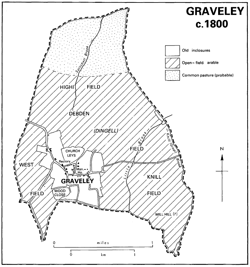
The western part of Graveley (fn. 5) lies mostly on a plateau at over 40 m. (130 ft.). Further east the ground falls gradually into a valley at c. 30 m., down which two watercourses, the northern one called Spetchley brook by 1615, (fn. 6) run to join Knill brook. The parish lies upon a thick bed of Oxford clay, (fn. 7) overlaid except in the southeast with boulder clay, once heavily wooded. Graveley's name indicates its origin as a woodland clearing. (fn. 8) In 1086 there was sufficient wood for building and fencing. (fn. 9) About 1120 Ramsey abbey acquired a wood, partly assarted, (fn. 10) which covered 8 a. in 1279. (fn. 11) Oaks and ashes were being felled there c. 1348. (fn. 12) Still fenced c. 1458 (fn. 13) it had probably gone by 1558. (fn. 14) It may have occupied Wood close (c. 9 a.) by Wood Green Lane south-west of the village. (fn. 15) Despite the heavy soil Graveley has been devoted almost entirely to farming. The arable was cultivated in open fields, after 1400 on a triennial rotation, until inclosure in 1802.
In 1086 the recorded inhabitants were 16 peasants and 4 servi, (fn. 16) by 1200 c. 35 tenants. (fn. 17) There were c. 45 resident landholders in 1279 (fn. 18) and 44 taxpayers in 1327. (fn. 19) The number attending the single manor's harvest boons declined from c. 125 in the 1310s to c. 85 by 1360 and c. 65 in the 1380s. (fn. 20) In 1377 the poll tax was paid by 94 people. (fn. 21) Further depopulation followed in the early 15th century, when 9-12 people from c. 10 families of bondmen emigrated. (fn. 22) By 1524 there were only 20 taxpayers, (fn. 23) and in 1563 23 households. (fn. 24) In 1604 45 men were presented for not practising archery. (fn. 25) The population may have nearly doubled between the 1560s and the 1630s to almost 200, but fell again from the 1660s before stabilizing, perhaps at c. 150. (fn. 26) There were 81 adults in 1676, (fn. 27) 30-34 houses under Charles II, (fn. 28) and still 34 families, comprising 120 people, in 1728. (fn. 29) From 156 in 1801 the population increased rapidly to 207 by 1811, (fn. 30) then, despite high infant mortality, to c. 250 in the 1820s and a peak of 334 in 1851. It then declined, partly through emigration, to 294 in 1871 and more sharply to 207 in 1881, before stabilizing at c. 175 from 1881 to 1911. (fn. 31) In the 1890s most young people were leaving the parish. (fn. 32) Numbers grew again from the 1920s to over 200 in the 1950s and after a decline by 1971 had recovered to 244 by 1981. (fn. 33)
The village stands on high ground in the south-west. (fn. 34) Its main street, flanked by lanes winding through the closes, runs east and west between two small greens and widens at the middle into a third green, from which Church Lane, mentioned in 1439, (fn. 35) leads north to the church. From the western green roads diverge towards the Offords and Toseland (Hunts.), while from the eastern a road leads across Papworth St. Agnes towards Ermine Street. The inhabited area was probably shrinking from the late 14th century. Seven ruinous dwellings were reported in 1399 (fn. 36) and six in 1434, despite rent remissions to encourage repairs. (fn. 37) In 1402 it was thought useless to rebuild a house because noone would live there. (fn. 38) About 1540 there were only 18 houses and 4 cottages, (fn. 39) probably half those existing in 1279. (fn. 40) Renewed growth after 1550 led to new building. (fn. 41) In 1654 there were only eight cottages anciently entitled to common rights, while newly built ones on the waste were often reported in the early 1650s. Despite plans in 1656 for their eventual demolition, (fn. 42) at least six still stood after 1700. (fn. 43) Under Charles II most houses had only one or two hearths, only four having three or more. (fn. 44) Among the cottages were probably a row of three stud-built ones near Church Lane, perhaps the town houses mentioned in 1685. (fn. 45) In the 1960s five other 17th-century dwellings survived: Rookery Farm south-west of the church, of three bays with a crosswing, demolished in 1971; Baldock Farm south of the main street, later given brick walling; and three one-storeyed cottages. (fn. 46)
The number of buildings hardly increased between 1700 and the 1830s, when there were only 32 houses for over 50 families. (fn. 47) Of c. 60 dwellings in the mid 19th century most still lay along the street and three or four at Duck End on the Offord road. (fn. 48) Eight houses were empty in 1871 (fn. 49) and barely 40 were inhabited from the 1880s. (fn. 50) In 1897 there were 10 houses and 28 cottages. (fn. 51) In 1910 besides 15 houses, 8 occupied by farmers, there were 26 cottages, of which at least 8 were overcrowded. (fn. 52) After 1949 the number of houses increased, mainly through infilling, to c. 60, including 26 council houses, some built c. 1924, others after 1955. (fn. 53)
Graveley usually had one principal public house. The Chequers on the main street, licensed from the 1760s (fn. 54) and burnt down c. 1900, (fn. 55) was succeeded by the White Lion, and that after 1900 by the Three Horseshoes, still open in 1981. (fn. 56) The village Feast, c. 1910 held on 20 June, close to St. Botolph's day, was replaced c. 1912 by a flower show held in July. (fn. 57)
In 1941 106 a. between the Offord and Toseland roads were requisitioned to form part of Graveley airfield, mainly in Offord Darcy (Hunts.) and intensively used by bomber squadrons between 1942 and 1945. The section in Graveley, bought by the government c. 1950, contained the end of the main runway, roads, and various buildings. The airfield closed in 1946 but was again used in the late 1950s as a relief landing ground for Oakington. After 1967 the buildings were mostly removed and the land was sold for farming. (fn. 58)
Graveley c. 1800M