A History of the County of Chester: Volume 5 Part 2, the City of Chester: Culture, Buildings, Institutions. Originally published by Victoria County History, London, 2005.
This free content was digitised by double rekeying. All rights reserved.
'Major buildings: The Rows', in A History of the County of Chester: Volume 5 Part 2, the City of Chester: Culture, Buildings, Institutions, (London, 2005) pp. 225-239. British History Online https://www.british-history.ac.uk/vch/ches/vol5/pt2/pp225-239 [accessed 11 April 2024]
In this section
THE ROWS
Since the Middle Ages the most distinctive element of the four main streets of Chester has been the Rows, a system of largely continuous first-floor galleries, raised above undercrofts and incorporating public walkways which run parallel with the street below and give access to shops on the inner side, and a stallboard or open area for the display of goods on the outer. Although galleries with shops were a common feature of medieval urban buildings, the Chester Rows are remarkable for running through groups of adjoining buildings in multiple ownership. The feature, which has been the subject of comment since the mid 16th century, is clearly ancient. (fn. 1) Despite the loss of almost all the medieval structural evidence above the level of the undercrofts, there are indications that Row galleries occurred in several widely separated places within the four main streets from an early period. Unambiguous traces of a gallery running through adjoining plots survived in 2000 at nos. 28–34 Watergate Street, where it was spanned by arches set within the party walls between the two houses and with a simple profile which, though obscured by stucco, is consistent with the mid 13th-century date of other parts of the buildings (Fig. 138). (fn. 2) A similar arch spanning the Row at no. 32 Eastgate Street survived until the mid 19th century, (fn. 3) and in the 1990s there were also traces of early gallery openings in party walls at nos. 48 Bridge Street and 6 Lower Bridge Street, both at some distance from the Cross. (fn. 4)
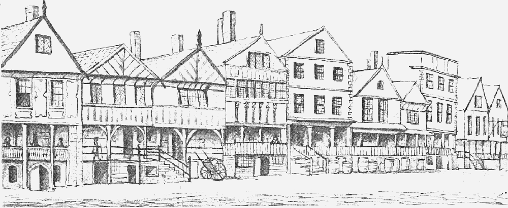
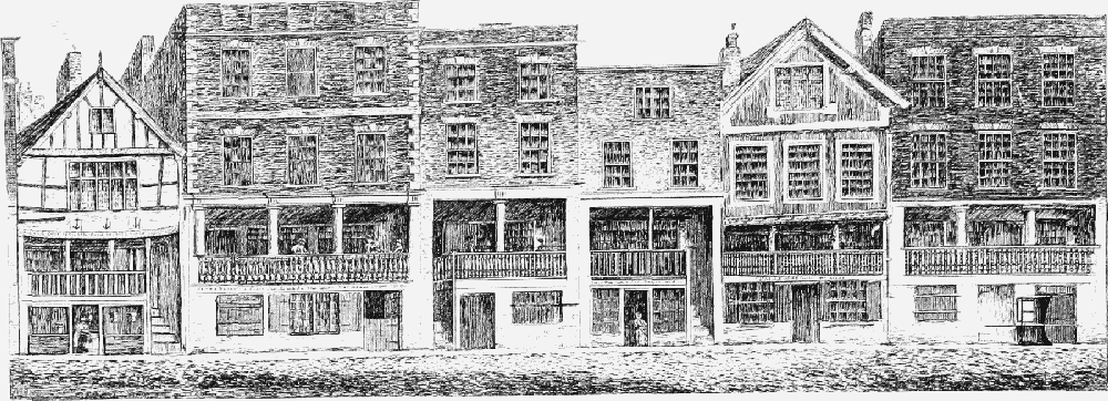
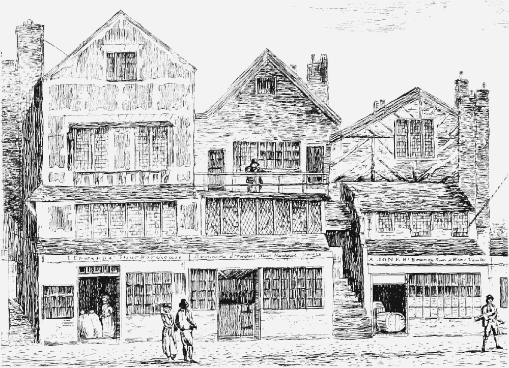
Watergate Row South in later 18th century
Origin and Early Development
The Rows are unlikely to have originated much before 1200. The only indication of an earlier date is a tradition, probably 14th-century, that property on the north side of Eastgate Street recorded in 1155 was known as Lorimers' Row. (fn. 5) At the west end on that side of the street, however, the Buttershops or Bakers' Row occupied a site which was apparently still open ground in the 12th century. (fn. 6) Otherwise, Rows were first recorded in 1293 near the Cross at the centre of the city. (fn. 7) One of them, Ironmongers' Row, lay immediately north of St. Peter's church, and may have originated in four shops which abutted the church by the 1220s. Whether the term Row already had the specialized meaning of 'elevated walkway' in the 1290s is uncertain, and the earliest unambiguous instance of such a usage is in 1356. (fn. 8) Ironmongers' Row was nevertheless probably elevated above the street, since Northgate Street is known to have had undercrofts by the 1280s and commercial premises above them by the 1340s. (fn. 9)
Although first mentioned only in the mid 14th century, Fleshers' Row on the north side of Watergate Street abutting St. Peter's was probably in the form of a Row by the late 13th century. Buildings on the site, owned by the influential Doncaster family in the 1290s, included two adjacent properties comprising shops and rooms over undercrofts by the 1340s. (fn. 10) By 1398 the Row ran west as far as Goss Lane. (fn. 11)
Opposite St. Peter's on the north side of Eastgate Street the building or group of buildings known c. 1270 as the Buttershops contained a Row by 1369. (fn. 12) It was exceptional in being located within substantial structures more than one storey high, shops with rooms above them, as early as 1361. (fn. 13) The Row ran into and was sometimes confused with Bakers' Row immediately to the east. That Row, named from its proximity to the important bakehouse belonging to St. Giles's hospital, existed by 1293. (fn. 14) By 1375 it was associated with undercrofts, and it seems likely that it was a Row by the 1290s. (fn. 15) Other early Rows of similar form included Cornmarket Row on the south side of Eastgate Street, and Corvisers' Row, probably within the structures on the west side of Bridge Street known in the 1270s as the Shoemakers' Selds. (fn. 16)
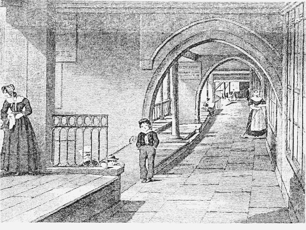
Watergate Row North in 1849, showing 13th-century arches
In the late 13th and early 14th century Rows thus existed in many places in the four main streets. For long it was believed that they had evolved gradually, though the factors which engendered the development proved difficult to isolate. (fn. 17) Later, it was argued that they were deliberately planned after the destructive fire of 1278. (fn. 18) A detailed programme of interdisciplinary research conducted between 1985 and 1992 suggested more convincingly that the Rows emerged gradually between c. 1200 and 1350 through the adaptation of a common form of urban domestic building, the splitlevel house with an undercroft, to the unusual circumstances present in the centre of Chester. (fn. 19) One important element, recognized long previously, was the peculiar topography of the city centre, where the accumulation of material from collapsed Roman buildings caused the ground level to rise quite steeply on either side of the main thoroughfares. (fn. 20) The difference in levels was such that the characteristic Row building had its first floor fronting the street on a level with the ground floor at the rear. Moreover, because of the height of the rear levels and the presence of bedrock immediately beneath the street surface, the first storeys had to be set relatively high. For external access they thus required substantial stairways which projected inconveniently into the highway and darkened the narrow frontages which gave the undercrofts their sole source of light. The Row walkway provided a means of limiting the number of stairways from the street without restricting access to the first-floor premises.
Another prerequisite for the Rows, 'a reasonably continuous occupation of the street frontages', had undoubtedly long existed in Chester. (fn. 21) The crowding of buildings on to the street frontages resulted from the commercial desirability of a location on the four main thoroughfares. It was apparent both in the concentration of shops and in the frequency with which property changed hands in the 13th and earlier 14th century. (fn. 22) Such pressure led to a demand for the maximum commercial space along the street, and hence to the appearance of so many shops at first-floor level.
It may be that such factors alone account for the emergence of the Rows. Certainly, they are consistent with the variable character and wide date-range of surviving Row buildings and with their evidently gradual evolution to become the norm in the principal streets. Nevertheless, the appearance of walkways running through adjacent properties in different ownership was remarkable. While there is no hint of anything so radical as a requirement upon house owners in the four main streets to reconstruct their property so that a public thoroughfare could run through it at first-floor level, it remains possible that a single early development somewhere in the city provided an influential model. The Rows seem always to have housed commercial premises and the earliest ones to be recorded were invariably linked with a single trade. That suggests that they may have owed something to the co-operation of members of the same craft, a process easier to secure in Chester than elsewhere because of the persistence there of a guild merchant covering all the trades and acting as a governing body for the whole city. (fn. 23) The selds, which contained a Row from an early date and were perhaps the area in which the stallboards were pioneered, were especially closely associated with the guild merchant, which met there until 1250. (fn. 24) Possibly the guild was responsible in the mid 13th century for laying out the first Row which became the pattern for others. Alternatively, the concentration of shops and early evidence of Rows around St. Peter's might suggest that the Rows originated in a comprehensive rebuilding on land associated with that church, perhaps the urban estate to which St. Peter's was originally attached. (fn. 25)
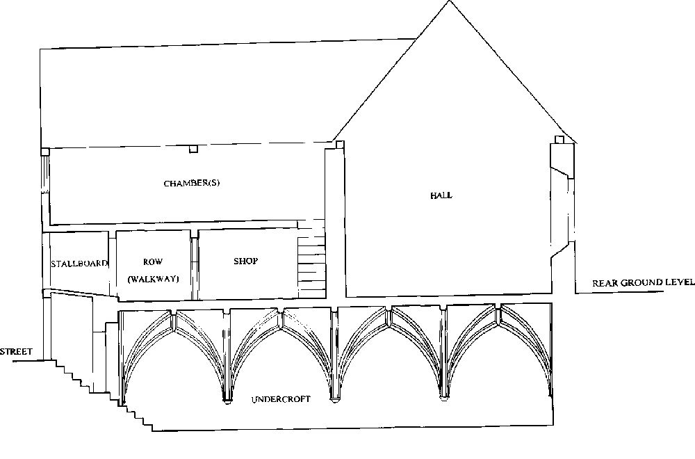
Elements of a typical house in the Rows
Physical Form of Row Buildings
Burgage Plots
One of the determinants of the form of Row buildings was the division of property along the main thoroughfares into long narrow plots in order to provide access to the street for as many owners as possible. In the early 13th century such holdings were occasionally described as 'burgages' (burgagia), but more often simply as 'land' (terra), 'plots' (placeae), 'messuages' (messuagia), or 'tenements' (tenementa). (fn. 26) As is implied by the use of such varied and unspecific terminology, the plots were in no way uniform. The few plot measurements recorded varied greatly, widths from as little as c. 5.5 m. to nearly 17 m., and lengths from c. 10 m. to over 48 m. (fn. 27)
Undercrofts and Frontages
The buildings erected on the plots were diverse in size but had a number of standard elements. Most striking are the undercrofts, many of which survived in 2000, which were almost invariably built at the front of plots and at right angles to the street, and were only partially below ground level. (fn. 28) Such structures were common in medieval English towns, doubtless because of the security which they afforded for the storage of valuable commodities, especially wine, and because they doubled the frontage available for commercial purposes. In the main streets of Chester they were exceptionally numerous, generally comprising single cells ceiled with heavy timbers, but also including grand stone-built examples, best represented in 2000 by the stone-vaulted and arcaded undercroft at no. 11 Watergate Street. They varied in size from 3.7 m. to 9 m. in width, and from 10 m. to 41 m. in length, and do not seem to have been the product of a single plan. Their existence provided an essential, though not of itself sufficient, precondition for the development of continuous first-floor walkways above them.
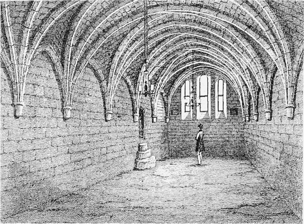
Undercroft at no. 12 Bridge Street, 1849
The undercrofts which can be traced to the 13th and 14th centuries were generally relatively wide. Above them, at Row level, were groups of small shops usually no more than 2 m. wide and 3 m. deep. A single merchant house might contain anything up to five such tiny lock-ups. (fn. 29) Such concentrations of shops above relatively high-set undercrofts made a common walkway at first-floor level especially desirable.
The nature of the medieval frontages to the undercrofts can be determined from a few known instances, at nos. 28 Eastgate Street, 6 Lower Bridge Street, and 11 and 25 Watergate Street. Each had a central doorway up to 1.5 m. wide with flanking windows. Access and illumination would otherwise have been difficult to provide for: only one undercroft is known to have had a rear light-well, and only the Leche House (no. 17 Watergate Street) certainly had access by stairs to the rear of the undercroft. (fn. 30) The fact that the undercrofts were often divided into sections each requiring its own door and windows made especially heavy demands upon the frontage. At nos. 32–4 Watergate Street, for example, the surviving timber arcade, grooved to take wattle and daub partitions, implies a division into three longitudinal sections, each only 2.6 m. wide internally. If, as was probable, there were three upper-level shops, the benefits of a gallery approached by only a single flight of steps are clear. In 2000 such steps occurred on average at every third plot, a distribution which may well reflect medieval commercial groupings in the 13th and 14th centuries.
Domestic Accommodation
Behind the shops, at Row level and above, lay domestic accommodation reached by passages leading from doors opening on to the walkway. (fn. 31) Buildings took two main forms. In the simpler and much more common type the hall was placed at right angles to the Row, while in the grander houses, usually at corner sites, it ran parallel to the walkway across several undercrofts. The presence of the Row affected the layout of the houses, precluding the courtyard plan found in other towns. The Row's overriding importance in the planning is evident from the fact that the main entrance at the cross-passage of such houses was approached from the street only indirectly and inconveniently by steps at either end of the frontage. (fn. 32)
Access stairs and domestic accommodation in Watergate Row South, 1818
Selds
The structures referred to in local sources as seldae, 'selds', have long been thought to have made an important contribution to the development of the Rows. In the past it has been suggested that they were long strips of property in front of the undercrofts, and that building over them was what enabled Row walkways to be developed at first-floor level. (fn. 33) That theory, however, is based on a misconception of the nature of selds. They are most plausibly viewed as 'private bazaars' into which were gathered stalls selling a particular form of merchandise, perhaps under privileged regulations. (fn. 34) The resemblance of Chester's selds to market halls is confirmed by a dispute in 1288–9 over the right of way through one of them. (fn. 35)
The selds were concentrated in Bridge Street, on the western side near Commonhall Lane. (fn. 36) They occupied the area in front of the common hall itself and extended northwards to the junction of Bridge Street with Watergate Street, where in the early 15th century lay the 'Stone Seld', probably that which in the 1270s adjoined Mayor John Arneway's seld in Bridge Street. (fn. 37) The whole quarter was known in the 13th and 14th centuries simply as 'the Selds'. (fn. 38)
In Chester a seld was sometimes an individual stall or booth but more usually a structure much bigger than a single shop. In the mid 13th century, for example, Mayor Arneway was granted half a seld measuring 10 ft. by 52 ft. (fn. 39) The tenement plots in Bridge Street immediately east of the common hall are very long and narrow. No. 32, for instance, is 40 m. long and less than 4 m. wide, dimensions similar to those of a seld recorded at Middlewich in 1334. (fn. 40)
Like those in London's Cheapside, the selds of Chester were elevated above undercrofts and probably fronted by shops. (fn. 41) They undoubtedly contained a Row. In 1356 the mayor and citizens granted a small piece of land in Bridge Street 'next to the new steps which lead towards Corvisers' Row at the end of the Fishboards, next to the pillory of Chester, in the corner towards the church of St. Peter'. (fn. 42) The 'Row' was thus an elevated walkway reached by steps and running along the west side of Bridge Street southwards from the junction with Watergate Street. (fn. 43) Although the steps were new in 1356, the Row was probably much older. In 1275 Robert le Barn, agent of Vale Royal abbey, leased to Alexander Hurrell, a former sheriff and later mayor of Chester, a group of 11 shops for the large sum of 40 marks. (fn. 44) The lease, originally for 12 years, was apparently soon terminated, since by 1278 Robert had granted the same properties in perpetuity to Vale Royal. (fn. 45) The shops were then called collectively the Shoemakers' Selds (seldae sutorum); they lay in Bridge Street between land belonging to St. John's hospital and that of Ralph of the pillory, probably the pillory which in the mid 14th century stood next to the steps leading to Corvisers' Row. (fn. 46) By 1334 Vale Royal owned 15 shops and a burgage in Chester, all apparently on a single site, and at least one of the shops was held by a corviser or shoemaker. (fn. 47) The connexion with Corvisers' Row is clear. It seems likely, therefore, that the Row existed in the 1270s when the Shoemakers' Selds were first recorded. Almost certainly it was linked with Saddlers' Row further south, which contained shops belonging to the Erneys family in 1342 and perhaps as early as 1293, and was evidently associated with their seld near the common hall. (fn. 48)
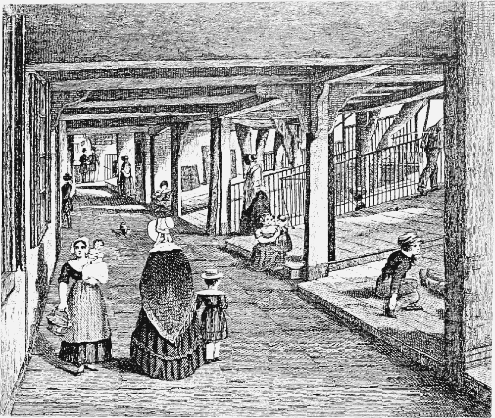
Row walkway and stallboards, Bridge Street Row West, 1847
The selds declined and virtually disappeared after the earlier 14th century, although the structure on the corner of Bridge Street and Watergate Street continued to be known as the Stone Seld and later as the Staven Seld. (fn. 49)
'Porches' and Stallboards
In the earliest Row buildings the walkway was apparently flush with the frontage. Soon, however, the trading space within the galleries was extended by the addition of stallboards between the walkways and the street fronts, normally sloping gently up from the walkway side and used for the display of merchandise. Stallboards appear to have developed as the roofs of light lean-to timber shelters or 'porches' (porcheria) added at the front of the undercrofts. (fn. 50) Though such structures nowhere survived in 2000, their existence may be inferred from the fact that in many cases the side walls below the stallboards were then predominantly of 18th- and 19th-century brickwork. (fn. 51) Stallboards supported by a stone porch in substantial townhouses such as nos. 38–42 Watergate Street were not apparently part of the original construction.
As early as 1293 indictments were made regarding the erection of obstructions to the public highway, including both steps and shelters. The 'porches' then erected by Hugh of Brickhill in front of four vacant houses in Bakers' Row in Eastgate Street represented an early example of encroachment large enough to support stallboards. Although the structures were initially condemned as injurious to the highway, commercial pressures were such that ultimately they were accepted by the authorities. (fn. 52)
Land annexed from the highway for porches was deemed to be still in public ownership. In 1508, for example, the Staven Seld at the corner of Bridge Street and Watergate Street was fronted by narrow strips of land which belonged separately to the mayor, sheriffs, and citizens of Chester. (fn. 53) In Bridge Street the strip was 2½ 'virgates' (2.3 m.) (fn. 54) wide and c. 185/8 virgates (17 m.) long, dimensions which correspond with the length of the street frontage of the seld and the width of the pre19th-century stallboard above. In Watergate Street, where the corresponding dimensions were 2 virgates (1.8 m.) and 21½ virgates (19.7 m.), it may be significant that the medieval frontage lay 2.4 m. back from the modern line. (fn. 55)
The strips which fronted the Staven Seld had probably long been in civic hands. In 1356 the mayor and citizens owned a plot of land, 2 ells (2.3 m.) wide and 3 ells (3.4 m.) long, lying next to the steps leading to Corvisers' Row. (fn. 56) It thus appears that between the 1290s and the mid 14th century the local authorities abandoned their attempts to prohibit the extension of Row properties into the highway in the four main streets, but retained ownership of the land encroached on. Already in the late 13th century the encroachers included such leading citizens as Hugh of Brickhill. Perhaps Edward I's charter of 1300, in granting jurisdiction over Crown pleas to the mayor and bailiffs and licensing the citizens to build on vacant sites, removed any final constraint on the process, or at least allowed the civic community, as opposed to the king's representative, to charge rent for encroachments. (fn. 57)
The local use of the term tabula throws further light on the early development of stallboards. Though it could mean simply a trestle or stall, it was also applied in Chester to more permanent structures. (fn. 58) In 1355, for example, one holding included a tenement and two undercofts, a quarter share of a seld, a shop, and another undercroft and tabula, (fn. 59) the last evidently a fixture. In the mid 15th century one citizen paid the city 4d. a year rent for 'a certain piece of land under the tabula' of another. (fn. 60) It is unlikely that any use would have been found for a small piece of land under another man's stall. If, however, the tabula was a stallboard the rent may have been for the strip of ground below it at street level. In 1445 the same tenant was paying an identical rent for a piece of waste ground in Bridge Street flanked by undercrofts and between the house frontages and the highway. Very probably it was the same property. (fn. 61) Many of the tabulae were located in Bridge Street and several were expressly linked with selds. (fn. 62) Perhaps, therefore, the tabulae were at first newly developed structures in front of the selds for the display of cloth at Row level, possibly at fair time when commercial space was at a premium. (fn. 63)
Row Walkway
The ambiguous origins and legal status of stallboards and the land beneath them have parallels in the Row walkway itself. It began as private property and continued to be deemed an appurtenance of the property through which it passed. Nevertheless, it eventually attained the status of right of way under the control of the civic authorities. How and when that control was acquired is not clear. By the mid 14th century the Row in the Buttershops was regarded as a highway (alta via), and thus perhaps as public. (fn. 64) No civic regulations relating to the Rows survive before the early 17th century, when it was accepted that the owner needed the corporation's permission for any action which impeded access or caused obstruction to the Row walkway. (fn. 65) Possibly such regulation had been imposed in the earlier 16th century, when mayors such as Henry Gee were much concerned to define and codify civic custom and law. (fn. 66)
Medieval Extent and Appearance
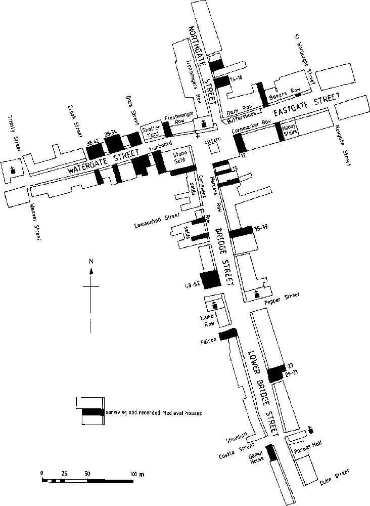
There was relatively little building within the city centre in the later 14th and 15th century. (fn. 67) Where there was reconstruction, as at Leche House (no. 17 Watergate Street) in the late 15th century, or the Old King's Head (nos. 48–50 Lower Bridge Street) in the mid 16th, the new buildings continued to contain a Row. (fn. 68) Probably, therefore, there were few additions to the Rows system, which may be assumed to have reached its full extent by c. 1350. Almost certainly by then the following areas, identified by their modern street names, contained substantial lengths of gallery.
Eastgate Street North
The stretches of Row on the north side of Eastgate Street were known variously as Dark Lofts (or Row), Buttershop Row, Bakers' Row, and Cooks' Row. (fn. 69) Buttershop Row overlapped with Bakers' Row by the early 14th century, and galleries extended as far east as St. Werburgh Street by the 15th. (fn. 70) Hardly any medieval structures survived in 2000, though a stone arch spanning the walkway was recorded at no. 31 (just west of St. Werburgh Street) c. 1840. (fn. 71)
Probable extent of the Rows in the Middle Ages
Eastgate Street South
Cornmarket Row was first mentioned in 1342, (fn. 72) and presumably ran through the complex of corn market, shops, kilns, and houses which existed by the 1270s. (fn. 73) A stone undercroft surviving in 2000 at no. 28, and twocentred chamfered arches shown in a 19th-century drawing as spanning the walkway at no. 32 were relics of the medieval Rows. Another stone-vaulted undercroft was recorded at no. 12 in 1855, but was later demolished. (fn. 74) The Row probably extended to Newgate Street; beyond that the walkway was presumably at street level, though in 1393 buildings with shops and undercrofts extended to the walls. (fn. 75)
Northgate Street West
Ironmongers' Row ran northwards from St. Peter's church to the market square by the late 13th century. (fn. 76)
Northgate Street East
Medieval undercrofts, surviving in 2000 only at no. 22, but formerly also at nos. 8 and 14–16, indicate that the Row extended northwards from the Buttershops to the market square. (fn. 77)
Watergate Street North
Fleshers' or Fleshmongers' Row ran westwards to Goss Street; beyond that the undercrofts and galleries at Booth Mansion (nos. 28–34) and at nos. 38–42 show that it continued at least to Crook Street, if not to Trinity Street. Medieval arches spanning the walkway at nos. 28–30 provide the earliest structural evidence of a gallery connecting adjacent holdings. (fn. 78)
Watergate Street South
The survival of a large number of medieval undercrofts, including three well built stone ones, suggests that the Row extended from the Cross at least to Weaver Street. (fn. 79)
Bridge Street West
Corvisers' or Shoemakers' Row ran south from the Cross through the Selds by the mid 14th century and probably by the 1270s. (fn. 80) Further south Saddlers' Row existed by c. 1300. (fn. 81) Undercrofts at nos. 12, 32, 36, and 48–52 suggest that the Rows ran along the full length of the street to Whitefriars. (fn. 82)
Bridge Street East
Medieval undercrofts at nos. 15 and 35–9 suggest that the Row extended south to Pepper Street. By the late 15th century it was called Mercers' Row. (fn. 83)
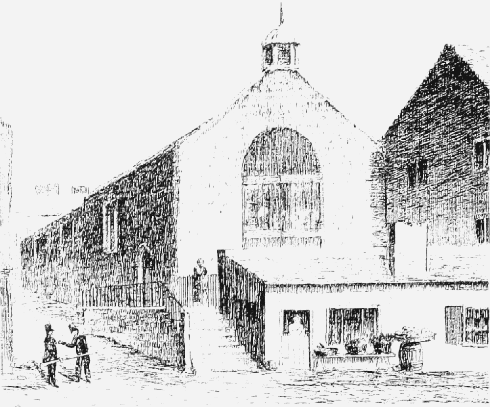
Terrace in front of St. Olave's, 1818
Lower Bridge Street
South of the Two Churches (St. Bridget's on the west side of the street, facing St. Michael's on the east) there were certainly galleried buildings and perhaps Rows from an early date. In the 16th century Mercers' Row allegedly occupied the whole east side of Bridge Street from the Cross to Dee Bridge. (fn. 84) On the west side the Falcon (no. 6) still in 2000 contained a large medieval undercroft and early evidence of a gallery. In the early 19th century Lamb Row (nos. 2–4, since demolished) was also galleried. (fn. 85) Further south, where the street drops towards the river, there may have been a raised open walkway, such as that which still existed in 2000 at Gamul House (nos. 52–8), perhaps extending as far as Shipgate Street. On the east side medieval masonry has been noted at nos. 27 and 29–31. The Row probably ran to Duke Street, incorporating Richard the engineer's house. Some sections seem to have taken the form of a raised walkway with no oversailing buildings, such as the terrace which in 2000 survived in front of St. Olave's church (Fig. 144). (fn. 86)
Appearance
It is difficult to establish what the medieval Rows looked like. At Thun (Switzerland) there are firstfloor walkways which are open and not oversailed by upper storeys, an arrangement similar to that which survived in 2000 on the west side of Lower Bridge Street and which may have disappeared from the eastern side only in the 19th century. In the city centre, however, in buildings such as nos. 28–30 Watergate Street, 48 Bridge Street, and 32 Eastgate Street, oversailing was clearly in place from the beginning, while similar arrangements were recorded in the 14th century in Ironmongers' Row in Northgate Street. (fn. 87)
Generally, it seems likely that the walkway was open at the front. In the earliest phases it probably overlooked the street, but by the later 13th century it was often separated from the street by an area for stalls or tabulae, a feature which originated in encroachment but was eventually an integral part of the structure. (fn. 88) In only one instance, the Dark Row, does the walkway seem to have been screened from the street by solid building, in the configuration preserved until the 1990s on the corner of Eastgate Street and Northgate Street. That it was unusual and made the Row notably ill-lit is indicated by the name.
Rebuilding, and Enclosure, 1550–1850 (fn. 89)
In the later 16th and early 17th century there was much rebuilding in the Rows, in particular of the superstructures above the undercrofts, the timber frames and elaborate frontages of which still survived in 2000 in considerable numbers. The new buildings continued to incorporate Row walkways, presumably because they remained commercially useful and because as earlier the upper storeys were in separate occupation from the undercrofts and therefore required independent access. Major projects included the rebuilding of the Buttershops and Dark Row in 1592, (fn. 90) and the new houses of Bishop Lloyd, Alderman John Aldersey, and the Mainwarings in Watergate Street. (fn. 91)
Although by then the Rows were under corporation control, (fn. 92) they continued in some sense to belong to the properties through which they passed, the owners of which were responsible for aspects of their maintenance, such as railings and stairways. (fn. 93) In the 1630s, for example, the corporation leased the Buttershops (or New Buildings) together with the Dark Row. (fn. 94)
The Rows remained an important and admired focus for trading. In the late 16th century William Smith praised the shops occupied by mercers, grocers, drapers, and haberdashers, to be found both at Row level and in the undercrofts; he was especially impressed by Mercers' Row which still apparently ran the full length of Bridge Street and Lower Bridge Street. (fn. 95) Elsewhere, however, undercrofts were used for storage, as workshops, and as taverns, and the best shops were at Row level. (fn. 96) By then, too, additional permanent retail structures were being created by the enclosure of stallboards. (fn. 97) There was especial activity at fair time (fn. 98) and on market days; in the later 17th century, for example, the flax and linen market was often held in the Rows on Watergate Street or Bridge Street. (fn. 99)

Bishop Lloyd's House, Watergate Street
Encroachment into the street in front of Row buildings continued to be licensed by the Assembly, whose income was increased by numerous small rents for the parlours, shops, and stairs thereby erected. Rent was also payable for extensions to upper storeys carried out over the street on posts. In the late 16th and early 17th century encroachments were especially numerous on the west side of Bridge Street. (fn. 100) By the mid 17th century they had a produced a notable rebuilding at nos. 22–6 (the Dutch Houses), timber-framed with two storeys above the Row adorned with twisted columns.
Enclosed Rows, Lower Bridge Street West, c. 1810
Such developments radically changed the character of the Rows. The enclosure of stallboards darkened the Row itself and the rooms or shops which opened on to it, a development illustrated in 2000 by Tudor House (nos. 29–31 Lower Bridge Street). By the early 17th century there were already complaints that shops on stallboards were a nuisance which deprived legitimate Row traders of light, created shelter for 'lewd persons' at night, and were used as latrines. (fn. 101) Nevertheless, the process remained unchecked. By 1662 the Row walkways seem generally to have been flanked by shops on both sides, (fn. 102) and throughout the late 17th century there were frequent applications to build new shops and chambers in them. (fn. 103)
Stallboard enclosures perhaps encouraged a move away from the hall at Row level to the street chamber over the Row as the principal room in houses in the main streets. Especially fine examples survived in 2000 at Tudor House, no. 17 Eastgate Street, and Bishop Lloyd's House (no. 41 Watergate Street), the last with notable plasterwork. (fn. 104) There was also some development of a fourth or attic storey where rooms might be furnished with fireplaces and plaster ceilings.
The Rows' commercial function appears to have been greatly undermined between the mid 17th and the mid 18th century, a development marked by the enclosure of approximately a third of the walkways and their incorporation within private housing. Removal of the walkways was perhaps encouraged by their increasingly dark and noisome character and by extensive damage to Eastgate Street and Watergate Street through bombardment during the final stages of the siege in 1645. (fn. 105)
Enclosure was licensed by the Assembly and successful applicants had to pay a fine and an annual rent, charges later simplified into a single payment. The earliest known example occurred in 1643 when Sir Richard Grosvenor successfully petitioned to enclose a portion of the Row within his house at no. 6 Lower Bridge Street (in 2000 the Falcon Inn). (fn. 106) Nothing further was recorded until the 1660s, after which enclosure gathered momentum until the 1720s, petitioners often describing the Rows as useless, dangerous, or seldom used, (fn. 107) and occasionally as allowing disorder at night. (fn. 108) The greatest losses were in Lower Bridge Street, initially on the west side where a long section, running south from Grosvenor's house to Bridge House (nos. 18–24), had disappeared by 1687 (Fig. 146). (fn. 109) On the opposite side, enclosure began in 1700 at no. 51, (fn. 110) and between then and 1730 there were c. 20 further petitions for Bridge Street as a whole. (fn. 111)
In Watergate Street, too, enclosure began early, in the 1670s. (fn. 112) Although the Row was retained near the Cross even in such a major reconstruction as Booth Mansion (nos. 28–34), (fn. 113) further west there were many losses, with at least eight petitions to enclose between 1700 and 1745. (fn. 114) When in the mid 18th century the city began to oppose complete enclosure, (fn. 115) the Rows in Lower Bridge Street and in Watergate Street west of Crook Street on the north side and Weaver Street on the south had almost entirely disappeared.
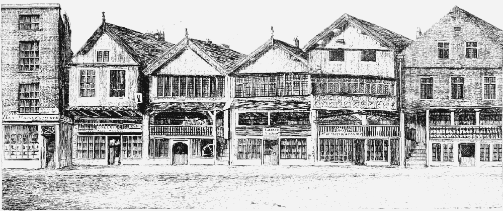
Uniform frontages, Eastgate Street North, c. 1810
Although there were some early petitions for Northgate Street, few were implemented and the Row on the west side remained intact. (fn. 116) In Eastgate Street, the city's main commercial centre, the process began later and was generally resisted by the Assembly, although there were a few enclosures, usually for shops. (fn. 117)
Except in Lower Bridge Street, there were few complete rebuildings in the Rows in the later 17th and early 18th century. Much more common was the refronting of premises. The Assembly was often petitioned for permission to move forward the boundaries of properties on the main streets, (fn. 118) sometimes to fence front plots, (fn. 119) but mostly to enable them to push out the front walls of houses by a few feet, (fn. 120) to make them level and uniform with those adjoining. (fn. 121) On at least some occasions the reconstructed frontages were of brick with a first-floor colonnade to light the Row walkway. (fn. 122)
Permission to enclose declined from the mid 18th century and virtually disappeared after 1770. Although as a result no substantial new houses were built, in the late 18th and early 19th century renewal of frontages continued. Gradually the Row walkway came once again to be regarded as a desirable feature. Cast-iron columns were introduced, and by the early 19th century Row openings were heightened when the buildings behind and above them were rebuilt. The stallboard structures, which darkened and obstructed the Rows and about which the Assembly had become concerned by the 1760s, (fn. 123) were largely removed in the early 19th century. (fn. 124) With the appointment of additional constables in 1815 and the introduction of gas lighting in 1818, the Rows were set to become once more respectable. In 1828, when William Brown built his grand store in Eastgate Street, the stone frontage in the Greek revival style incorporated a well lit Row walkway. (fn. 125) By then the Rows from the Royal Hotel on the south side of Eastgate Street to St. Michael's church on the east side of Bridge Street contained the best shops and formed a fashionable promenade. (fn. 126) Maintenance was further enhanced with the establishment of an improvement committee under the terms of the Chester Improvement Act of 1845. By 1847 the committee was requiring owners to repair the steps giving access from the street to the walkways. (fn. 127)
Reconstruction and Conservation, 1850–2000 (fn. 128)
By the mid 19th century the Rows had become an antiquarian attraction and the Chester Archaeological Society was recommending that they be preserved and where necessary reconstructed with appropriate timber-framed buildings. (fn. 129) They were also highly prized for their picturesqueness by the increasing number of tourists whom Chester attracted. (fn. 130) Early examples of Row buildings in the revived vernacular style survived in 2000 at nos. 36–8 Eastgate Street and 40 and 51–3 Bridge Street, the first designed by T. M. Penson in 1857, the others by James Harrison in 1858.
Vernacular revival buildings, Eastgate Street South: nos. 36–38 by T. M. Penson, 1857 (right) and nos. 40–44 by W. T. Lockwood, 1912 (left)
Antiquarian interest was accompanied by a desire for conservation, first expressed over no. 9 Watergate Street (God's Providence House) in 1861. (fn. 131) Although that building was in fact completely rebuilt, something of the style of its former frontage was preserved. By then the stone-vaulted crypt at no. 28 Eastgate Street had been preserved and incorporated by Penson in an otherwise High Victorian Gothic building for Browns department store. Despite such developments the early fabric of the Rows continued to be eroded. A major loss was the stone-vaulted and aisled undercroft at no. 12 Bridge Street, demolished in 1861 despite a campaign by the Chester Archaeological Society for its preservation. (fn. 132) A further setback, again accomplished against public opposition, was the destruction of the Row at the east end of Eastgate Street North to make way in 1860 for the Chester Bank, a large stone building with a pediment and Corinthian columns.
Other relatively modest buildings of the 17th and 18th century were swept away during the full flowering of the vernacular revival led by the local architects John Douglas and T. M. Lockwood. (fn. 133) Such work was usually thorough in its replacement of all that had gone before. Notable achievements included Lockwood's work at the Cross: the half-timbered no. 1 Bridge Street with its domed turret, built in 1888, and the brick and timber nos. 2–4 Bridge Street built opposite it in 1892. (fn. 134) Even more important was the reconstruction of Shoemakers' Row on the west side of Northgate Street, where a group of mainly 17th-century buildings had attracted low life and made the highway unduly narrow. The work was accomplished between 1897 and 1909, mostly to designs by Douglas, and although it did not incorporate an elevated walkway, the frontage preserved something of the character of the Rows, with a timber-framed arcade rising over low-set undercrofts or cellars. (fn. 135)
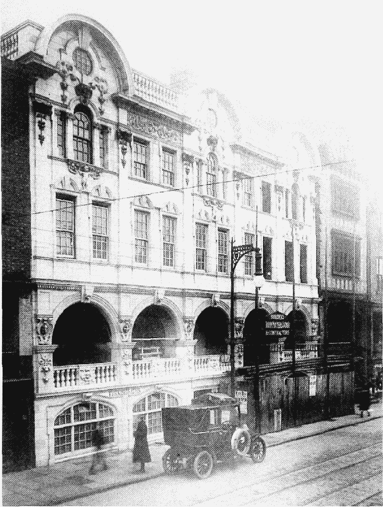
In 1909 W. T. and P.H. Lockwood, who had taken over their father's practice, rebelled against the prevailing half-timbered vernacular style and, under the patronage of the 2nd duke of Westminster, erected St. Michael's Row in Bridge Street, an incongruously bulky structure with a facade of white and gold Doulton tiles (Fig. 149). In 1911, however, in response to local protest, the duke, while professing his admiration for the building, personally paid for the facade to be replaced with the half-timbering deemed more appropriate. The tiles survived only on the ground floor and in the top-lit arcade of shops set behind and at right angles to the street frontage. (fn. 136)
The Lockwoods' experiment marked the end of a period of reconstruction within the Rows, when many new buildings were inserted, generally much larger than those which they replaced. Except in Shoemakers' Row they had all included a Row walkway, often made more convenient, with better lighting, more even floors, and improved steps from the street. The Rows system thus made a major contribution to the transformation of Eastgate Street, Bridge Street, and the southern end of Northgate Street into a modern shopping centre. Behind the improved frontages, however, the yards and rear buildings were until the 1930s crowded with much humbler workshops and residential buildings in insalubrious courts reached by narrow passageways from the Rows. (fn. 137)
St. Michael's Row as first built
Although the department stores in Eastgate Street continued to be enlarged between 1910 and the 1930s, no significant additions were made to the buildings within the Rows until the 1960s. (fn. 138)
In the early 1960s the insertion of the Grosvenor shopping precinct behind the Rows in Bridge Street East and Eastgate Street South greatly extended the retailing area to which the Rows gave access. In Watergate Street, until then relatively little altered, a medieval undercroft was lost to make way for Refuge House, and nos. 55–61 were replaced with a concrete brutalist building by Bradshaw, Rowse, and Harker of Liverpool (Fig. 150). Although that structure incorporated a Row, another new building of the period at nos. 42–8 Northgate Street did not. (fn. 139) A further replacement of Row buildings in modern materials took place at nos. 14–20 Watergate Street in 1970.
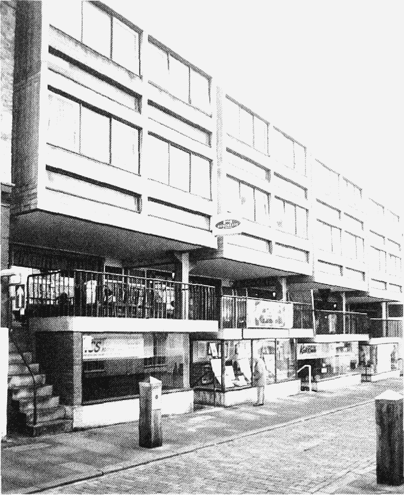
Nos. 55–61 Watergate Street
With the publication of the Insall Report in 1968, a number of dilapidated Row buildings including the Dutch Houses, Bishop Lloyd's House, and the Falcon were repaired. In 1988 a new building by Robin Clayton, of brick with a gabled facade, was erected at no. 12 Watergate Street, and in the early 1990s the Dark Row on the corner of Eastgate Street and Northgate Street was reconstructed by the Biggins Sargent Partnership, a development notable for its expansion of the Rows system. (fn. 140)