A History of the County of Essex: Volume 6. Originally published by Victoria County History, London, 1973.
This free content was digitised by double rekeying. All rights reserved.
'Becontree hundred: East Ham', in A History of the County of Essex: Volume 6, ed. W R Powell (London, 1973), British History Online https://www.british-history.ac.uk/vch/essex/vol6/pp1-8 [accessed 30 April 2025].
'Becontree hundred: East Ham', in A History of the County of Essex: Volume 6. Edited by W R Powell (London, 1973), British History Online, accessed April 30, 2025, https://www.british-history.ac.uk/vch/essex/vol6/pp1-8.
"Becontree hundred: East Ham". A History of the County of Essex: Volume 6. Ed. W R Powell (London, 1973), British History Online. Web. 30 April 2025. https://www.british-history.ac.uk/vch/essex/vol6/pp1-8.
In this section
THE HUNDRED OF BECONTREE (continued)
THE HUNDRED OF BECONTREE
EAST HAM
The Origin of North Woolwich, p. 8. Manors and Other Estates, p. 8. Economic History, p. 14. Marshes and Sea Defences, p. 17. Forest, p. 18. Local Government, p. 18. Public Services, p. 23. Parliamentary Representation, p. 24. Churches, p. 25. Roman Catholicism, p. 31. Protestant Nonconformity, p. 32. Judaism, p. 38. Education, p. 38. Charities for the Poor, p. 42.
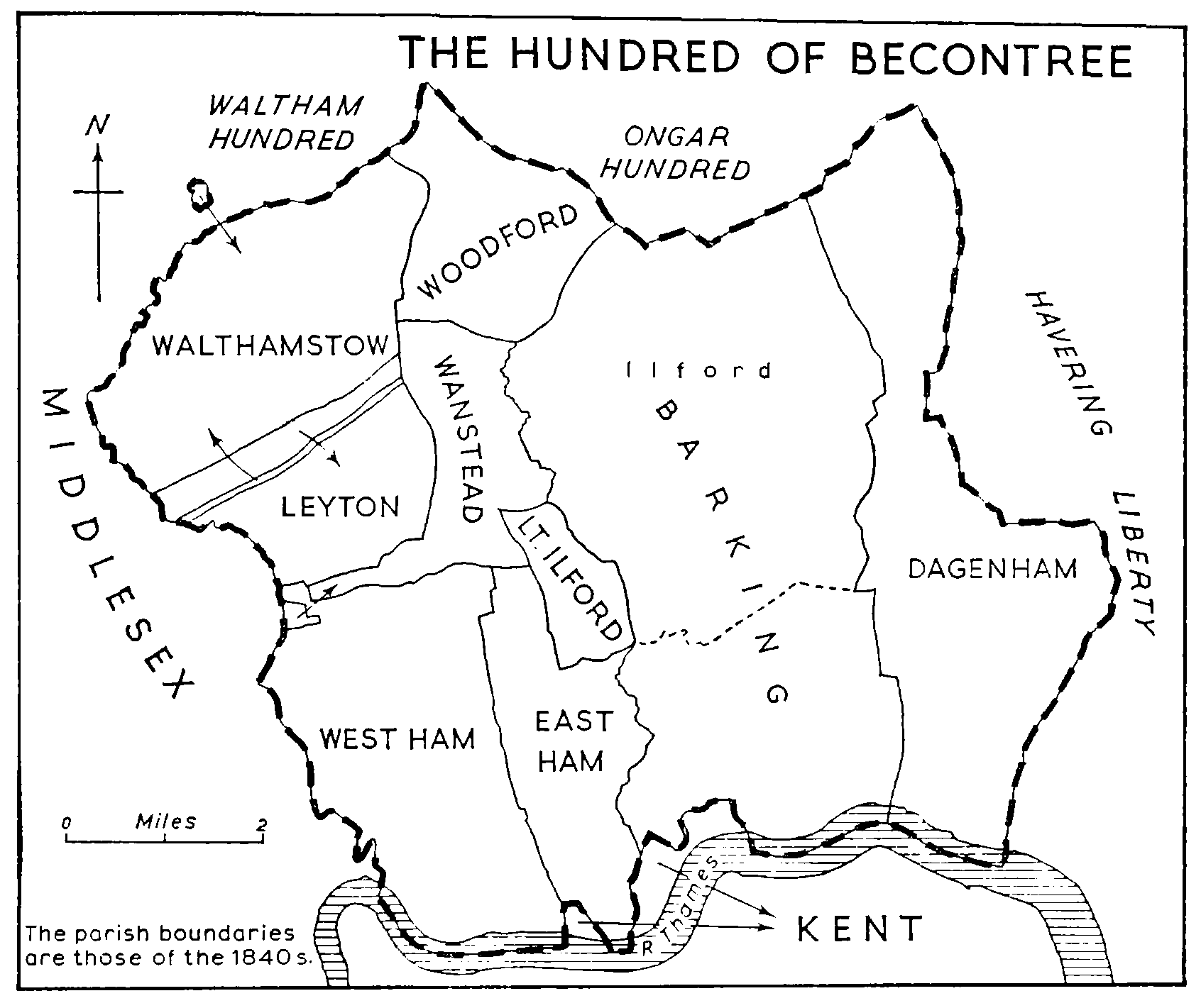
East Ham, about 7 miles east of London, is part of the London borough of Newham. (fn. 1) It is principally a dormitory suburb of small houses built between 1890 and 1910, with little industry except in the south, where are situated the Royal Docks and Beckton gasworks. The ancient parish extended from the Thames north for about 4 miles to Wanstead Flats. The eastern boundary, shared in the north with Little Ilford parish, followed White Post Lane (now High Street North) south to Jews Farm Lane (East Avenue). It then turned east to join Back river (a loop of the Roding), and marched with Barking parish down that river and across the marshes to the Thames. (fn. 2) The southern boundary followed the Thames for two short stretches, between which it curved inland, cutting off a small piece of Woolwich (Kent). Another piece of Woolwich, abutting on East Ham and Barking, lay farther east along Gallions Reach. The origin of these detached parts of Woolwich is discussed below. (fn. 3) The western boundary marched with that of West Ham from the southern edge of Wanstead Flats, down Green Street to the Thames. The ancient parish, which was entirely rural until about 1850, had an area of 2,498 a. (fn. 4) It became an urban sanitary district in 1879, and this was enlarged in 1886 to 3,266 a. by the addition of Little Ilford parish. (fn. 5) Further boundary alterations took place in 1893 with Barking, in 1901 with Wanstead, and in 1907 with both Barking and Ilford. (fn. 6) The most important was that of 1901, by which 96 a. of Wanstead Flats were transferred to East Ham, thus extending the northern boundary of the urban district by about ½ mile. East Ham became a municipal borough in 1904 and a county borough in 1915. In 1961 its area was 3,324 a. (fn. 7) It became part of Newham in 1965. That year has been taken as the terminal point of the present article, though a little later information has been included. This article also deals with the history of Little Ilford between 1886 and 1965; the earlier history of that parish is separately treated. (fn. 8)
The land rises from the Thames to a height of about 50 ft. on Wanstead Flats. Beside the Thames and the Roding are extensive alluvial marshes; elsewhere the soil is valley gravel. A former inlet of the Thames, called Ham creek, formed part of the boundary with West Ham. (fn. 9) Between 1656 and 1673 this seems to have been regularly used as a naval dockyard, subsidiary to the main yard at Woolwich. (fn. 10) It was occluded in the later 19th century during the industrial development of North Woolwich. (fn. 11) In the upland part of the parish there were a number of ponds and springs, of which the most notable was Miller's well, a medicinal spring situated at the point where the present Cheltenham Gardens joins Central Park Road. (fn. 12)
Roman remains, sufficiently numerous to prove a littoral settlement, have been found near St. Mary's church and at North Woolwich. (fn. 13) Until the later 12th century references to Ham ('low-lying pasture') do not distinguish between East and West Ham, and are therefore difficult to interpret precisely. (fn. 14) The Domesday evidence suggests that the main settlement then, as in Roman times, was in the south, and that the northern part of the parish was thickly wooded. (fn. 15) In 1086 the total recorded population of the two manors in East Ham was 72, indicating a substantial village. East Ham was not then greatly outranked in size by West Ham. It may have retained its relative position in the 12th century, when there was evidently much forest clearance in the parish, but between the 14th century and the 17th, while West Ham greatly increased in importance, East Ham seems to have stagnated or even declined. This was at least partly due to flooding in the later Middle Ages.
As late as 1670 there were only 79 houses in the parish. (fn. 16) The number increased to 94 in 1762 and to about 150 in 1796. (fn. 17) In 1801 the population was 1,165. It rose slowly to 2,264 in 1861. (fn. 18) Growth then became rapid, with industrial development on Thames-side, and suburban house-building advancing eastwards from West Ham. By 1891, having annexed Little Ilford, East Ham was a town of 32,713, and during the next 10 years it grew much faster than any other place of its size in England, to 96,018 in 1901. The peak population was reached about 1914, though the highest official figure, of 143,246, was recorded in 1921. Since the 1930s the population has decreased, partly as a result of wartime bombing, to 120,836 in 1951 and 105,682 in 1961. Since the Second World War many immigrants, mainly from the Commonwealth, India, and Pakistan, have settled in East Ham. In 1961 the resident population included 2,793 born outside the British Isles, or 2.6 per cent of the total.
Little is known of the later medieval pattern of settlement. The most important change in that period seems to have been the destruction by floods of the hamlet at North Woolwich. (fn. 19) The evidence for the existence of that hamlet includes the Domesday entry relating to Westminster Abbey's estate in East Ham (Hammarsh), and various later references, especially from 14th-century deeds. (fn. 20) Chapel field, mentioned in and after 1315, indicates the existence of a chapel then or earlier, and the foundations of that building were still visible in the 18th century. (fn. 21) Chapel field was in the larger or eastern detached part of Woolwich parish, just outside East Ham, (fn. 22) and it is clear that the hamlet lay across the boundary between the two parishes. One statement implies that this settlement was destroyed by a great flood in 1236 (fn. 23) but the process may have been more gradual, possibly culminating in the floods of the late 14th and early 15th centuries. From about 1500 the flooded lands at North Woolwich were being reclaimed, but until the 19th century they seem to have been used only for grazing, and not for habitation.
Eighteenth-century maps show the parish before modern changes. (fn. 24) In the extreme south and southeast lay undeveloped marsh land. In the north the 'lower forest' (Wanstead Flats) ran down to the Romford-London road. The principal local road, then as now, ran south from the Romford Road past the parish church to the marshes. The name East Ham Street, recorded in 1443, (fn. 25) probably applied to the central part of this road. The northern end was known in the 18th century and later as White Post Lane, from a post standing at its junction with Romford Road. These two stretches of the road now form High Street North. The present High Street South was formerly called East Ham Manor Road. The most southerly section of this spinal road, between the parish church and North Woolwich, retains its old name of East Ham Manor Way. In the 18th and early 19th centuries, when there was a small ordnance store at North Woolwich, Manor Way appears to have been maintained by the army (fn. 26) but the tradition that stone shot was used in its repair was not substantiated in 1896, when the U.D.C.'s surveyor carried out a detailed examination of the road in connexion with its diversion and straightening. (fn. 27)
Along the spinal road, and especially at its junctions with other roads, were most of the houses in the parish. The hamlet of North End lay at the point where White Post Lane was joined by Plashet Lane (now Plashet Grove) and Jews Farm Lane (now East Avenue). Jews Farm Lane probably acquired that name in the later 18th century. (fn. 28) In 1764 it was called Harrow Lane, from a public house. East Avenue commemorates Joseph East, first chairman of the U.D.C. (fn. 29) There was a cluster of houses at the junction of High Street and Wakefield Street, and another at South End, at the junction with White Horse Lane (now Rancliffe Road) and Vicarage Lane. Wake field, from which the street was named, occurs in 1674. (fn. 30) There were also hamlets at Wall End, near the Barking boundary, and at Plashet, at the junction of Plashet Lane and Red Post Lane (now Katherine Road). Green Street, in the west of the parish, was the southern end of the present street of that name; the northern end was formerly Gipsy Lane. Wall End, Plashet, and Green Street are all mentioned in 1460–1. (fn. 31) The first probably refers to an early wall against Back river, and the second to forest clearance. (fn. 32) Gipsy Lane continued to be a resort of gipsies until the area was built over. (fn. 33) The southern continuation of Green Street, now Boundary Road, which formerly terminated in the marshes, was called Blind Lane. The road linking Green Street and Red Post Lane was also known as Blind Lane: this is now Plashet Grove and Grangewood Street. White Horse Lane, named from a public house, ran from South End to Green Street on the line of the present Rancliffe and Central Park Roads. In the southeastern marshes were Gooseley Lane and Clapgate Lane. Those names, still used, are both found elsewhere in Essex. (fn. 34) The first, meaning 'goose pasture', no doubt refers to the wild fowl which frequented the marshes. (fn. 35) The second presumably comes from the swing gates preventing cattle from straying. The road from High Street to Wall End, now part of Barking Road, was formerly Watchhouse Lane or Wall End Lane. (fn. 36)
Before the 19th century East Ham's communications with the outside world depended mainly upon the Romford Road, which since 1721 had been maintained by the Middlesex and Essex turnpike trust. (fn. 37) There were also several lanes running west from Green Street to West Ham and Plaistow, but Barking, to the east, could be approached only by foot- or horse-bridges over Back river and the Roding. (fn. 38) About 1812 the Commercial Road turnpike trust built New Road (now Barking Road) from the East India Docks to Barking. (fn. 39) A toll-gate was set up at the junction with High Street. (fn. 40) New Road, which enabled traffic to by-pass Stratford, Ilford, and the centre of Barking, continued to serve as an arterial road until the opening of the East Ham and Barking by-pass in 1928. (fn. 41)
Modern development has, in the main, preserved the lines of the old roads, though, as shown above, many of their names have been changed. Most of the changes took place between 1885 and 1905, and are recorded in the minutes of the local board and the U.D.C. They were usually dictated by a desire for clarity or refinement. Of the more important local roads of early origin only Katherine Road bears a completely new name, commemorating the daughter of Elizabeth Fry. (fn. 42)
Apart from the road pattern hardly anything remains in East Ham that is older than the 19th century, except the ancient parish church. Even before urban development began there appear to have been few surviving houses more than 150 years old, and none earlier than the 16th century. East Ham Hall, immediately north of the parish church, and the vicarage, about 500 yards farther north, were probably on medieval sites, but both were rebuilt in the earlier 19th century. The manorhouse of East Ham Burnells had apparently been demolished before the early 17th century. The earliest secular building in the parish of which there is a detailed description was the mid-16th-century Green Street House, also known as Boleyn Castle, which survived until 1955. (fn. 43) Three other buildings were probably of 16th-century origin: the Harrow, High Street North, (fn. 44) the old Duke's Head, Barking Road, (fn. 45) and the old White Horse, on the west side of High Street South. (fn. 46) Of these the Harrow was converted into a private house in the 19th century, and later demolished, while the Duke's Head was rebuilt early in the present century. The White Horse, which had been rebuilt in the 18th century, was replaced in 1905 by a new building on the east side of the street; it was again rebuilt in 1965. (fn. 47) Plashet House, Plashet Lane, was mentioned in 1615, when Richard Glover, who had bought it from Robert Thomas, died leaving it to his son and namesake. (fn. 48) It later passed to the Bendish family, impropriators of East Ham rectory, who sold it in the middle of the 18th century to Charles Hitch. (fn. 49) From 1784 to 1829 it was the home of the Fry family, and it figures prominently in the reminiscences of Katharine Fry, (fn. 50) who also described its later history. It was demolished about 1883. A drawing made in 1806 shows a central block of two storeys with attics, apparently of the early 18th century. (fn. 51) There were two wings, said to have been added by Charles Hitch. (fn. 52)
Breame's alms-houses, High Street South, were erected about 1630, and rebuilt at the end of the 18th century. (fn. 53) Rancliffe House, Rancliffe Road, was probably built early in the 18th century. It was a large square building of three storeys. (fn. 54) The house and grounds were bought in 1896 by the U.D.C., to make Central Park. (fn. 55) The house was demolished in 1908. (fn. 56) Oak Hall, High Street North, and Clock House Farm, High Street South, were other square brick houses of the same type and period. Burges House, Wakefield Street, was probably also contemporary with Rancliffe House. In the early 18th century it was the home of Ynyr Lloyd. (fn. 57) It was a two-storey brick building with a frontage of five bays. (fn. 58)
Lloyd, a wealthy business man working in London, was a type of resident already common in some Essex places near the city but previously rare here. Between 1750 and 1850 East Ham was attracting such men in increasing, though never large numbers, and this was naturally reflected in its buildings. Lloyd's nephew Ynyr Burges lived in an unnamed house in High Street South, which had been built about 1760 and which he enlarged in 1774. (fn. 59) Among other large houses probably dating from the later 18th century were The Limes and Wood House, both in High Street North; the latter was unusual in having a weather-boarded façade and may have been entirely of timber construction. At Potato (or Plashet) Hall, a house of the same period in Romford Road, the roof was surmounted by an octagonal lantern. (fn. 60) This seems to have been a favourite feature in the area, probably because of the view it could command of the river Thames and its shipping. The old Black Lion in High Street North and the White House in Plashet Grove were probably built in the early 19th century. (fn. 61) The Manor House at Manor Park (fn. 62) and Plashet Cottage in Katherine Road, (fn. 63) both associated with the Frys, were certainly of that period. East Ham House in St. Bartholomew's Road, (fn. 64) with its 'Greek' porch, dates from c. 1830, and the Green Man, at the junction of Plashet Grove and Katherine Road, is in the gabled Tudor style of the mid 19th century. Meanwhile East Ham was attracting cottagers of a new kind: Irish potato workers. (fn. 65) These men and their families were housed in short two-storey terraces: Irish Row in Romford Road, Bullyrag Row in Wakefield Street, Salt Box Row in High Street South, and others. (fn. 66) Of all the buildings mentioned in this paragraph only three survive: the Green Man, East Ham House, and the Manor House at Manor Park.
Some verses written about 1850 refer to East Ham's 'dead flats … Marshes full of water rats, onions and greens, black ditches and foul drains'. (fn. 67) At that date, or a little earlier, the villagers still believed the parish to be haunted. (fn. 68) But it was beginning to lose its rural character. The first area to be thus affected was North Woolwich. In 1828 a philanthropist named Mills had tried to establish an industrial colony centred on a brickworks there. (fn. 69) This failed, but the opening of the North Woolwich railway (1847), (fn. 70) the Victoria Dock (1855), (fn. 71) and Henley's cable works (1859) (fn. 72) provided conditions more favourable to urban development. By the 1870s streets were being laid out on both sides of North Woolwich railway station, (fn. 73) and the transformation of the area was completed in 1880 by the opening of the Albert Dock. The houses built there during this period were crowded into long terraces, to accommodate the families of dock workers and sailors. The building of the King George V Dock (1912–21) necessitated the demolition of some of these houses. The area was heavily bombed during the Second World War, and since the war the East Ham section of North Woolwich has been largely redeveloped.
A mile north-east, still on the coastal fringe of the parish, the industrial village of Beckton grew up beside the great works of the Gas Light & Coke Co., opened in 1870. Here the workers lived in wellbuilt company houses, which are still in use. Between Beckton and North Woolwich was the housing estate of New Beckton. The first part of this was built in 1881, (fn. 74) and its street names commemorate persons and places that had been in the news during the previous decade, including Plevna (Street) and Cyprus (Place). Cyprus, as the whole estate was called for many years, was a squalid development, a long-standing nuisance to the local board because of its lack of main drainage. (fn. 75) Contemporary with it was another small slum area north of Vicarage Lane, at Bonny Downs. This pleasant name, taken from a field originally called Burnels Downs, (fn. 76) was also applied to one of the streets of the estate, which disappeared from the map when Bonny Downs Road and adjacent streets were redeveloped after the Second World War.
In the central and northern areas of East Ham the opening of railway lines by the Eastern Counties and the London, Tilbury, and Southend companies (fn. 77) had by 1860 prepared the way for rapid suburban development, and this started about 1880, when houses began to go up on the eastern fringes of the parish. (fn. 78) The Boleyn estate, east of Green Street House, commemorated by its street names not only Anne Boleyn, whose legendary connexion with the house is discussed below, (fn. 79) but also most of the other wives of Henry VIII. The houses there were also of the slum type, erected by builders who were continually contravening the by-laws. The area is now (1966) being redeveloped. The Woodgrange estate, at Manor Park and Forest Gate, was much better, and included some larger detached houses as well as terraces. The Manor Park side of it, from Durham Road to Romford Road, was mostly completed about 1883, and the Forest Gate side, from Hampton Road to Romford Road (so far as this lay in East Ham) a few years later. The developer was A. Cameron Corbett, who later built much of Ilford. (fn. 80) He operated on a large scale, and kept down his prices while maintaining a good standard.
South of Woodgrange, at Plashet, development began in 1883 with the sale of the Plashet House estate (between St. Stephen's Road and Plashet Grove). (fn. 81) This estate, with adjoining parts of East and West Ham, became known as Upton Park. By 1890 building was in progress in the whole Plashet area from Green Street to High Street North, including the estates of Plashet Cottage (Grosvenor, Eversleigh, and Spencer Roads), Plashet Hall (Sherrard, Halley, Strone, and Monega Roads), and Wood House (between Woodhouse Grove and High Street North).
Shortly before 1890 the Burges family, who were the largest landowners in East Ham, began to develop their estate, comprising some 400 a., mainly in the centre and east of the parish, but including sections in the south near St. Mary's church and in Roman Road. These developments went on steadily until the First World War, and were completed after the war. (fn. 82) Among them was the area between High Street North and Burges Road, and that to the south of St. Bartholomew's church.
The new estates at Upton Park and Plashet, and those on the Burges lands, were nearly all the same: long terraces of small but well-built dwellings for clerks and skilled workers. Most of the other houses built in East Ham between 1890 and 1914 were of similar type. The most important exception was at Manor Park, where some poor building took place between 1895 and 1899 on the Little Ilford Manor farm estate, part of which, in Grantham, Alverstone, and Walton Roads, soon became slums, which are now (1966) being redeveloped. (fn. 83) Council housing, before 1914, was represented by some 200 dwellings in cottage terraces, in Savage Gardens, New Beckton, and Brooks Avenue, off High Street South.
The most notable public building erected during this period was the town hall, completed in 1903, which stands at the junction of Barking Road and High Street South. It was designed by Cheers & Smith (fn. 84) and is built of dark red brick, lavishly ornamented with buff terra-cotta in a variety of early Renaissance styles. (fn. 85) The two frontages are set back behind trees and the angle between them is emphasized by a tall clock-tower. Adjoining the town hall are other municipal buildings erected a little later in similar styles and materials. The dominance of the clock-tower has been somewhat lessened since 1962 by the eight storeys of the new technical college on the opposite side of High Street South. The Methodist central hall, further east in Barking Road, formed part of the same group until its demolition in 1969. Other important churches built before 1914 are St. Michael's, Little Ilford (Romford Road) (1898–1906), St. Barnabas', Manor Park (Browning Road) (1900–9), and St. Bartholomew's, East Ham (Barking Road). St. Bartholomew's (1902–10) which replaced St. John's (High Street North) (1866, demolished 1925), was rebuilt in 1949–53 after war damage. East Ham's largest Anglican church, St. Stephen's, Upton Park (Green Street) (1887–94) was also bombed and was not rebuilt.
Between 1914 and 1939 there was little building. During the Second World War the borough suffered heavy bombing, especially in the south, and after the war the corporation undertook extensive redevelopment. (fn. 86) This includes Priory Court, Priory Road (1953), containing 96 flats in a multi-storey block, adjoining the old Boleyn estate, (fn. 87) and Durban Court, Katherine Road (1960), a 6-storey block with clinics on the ground floor and 30 flats above. (fn. 88) The largest scheme, completed in 1965, was the redevelopment of North Woolwich, providing 488 new dwellings. (fn. 89) This included the closure of the short roads linking Albert Road and Woodman Street; the building of small 'town squares' dominated by five-point blocks of 8-storey flats and closed by small blocks of flats and houses in Albert Walk; a local shopping precinct at the junction of Woodman Street and Pier Road; and the re-location of certain industries. The corporation also erected a number of new schools between 1945 and 1965. Plashet secondary school, Plashet Grove (1951), and the new technical college, High Street South (1962), both on confined sites, are multi-storey blocks of glass and concrete. The Langdon Crescent schools (1951–3), on the other hand, are low brick buildings, loosely grouped on an extensive site. A few churches have been erected since 1945, usually to replace older and larger ones, or those destroyed by bombing. Among them is the Wakefield Street Congregational church (1959).
The phenomenal growth of East Ham between 1880 and 1914 was made possible by a good transport system. (fn. 90) The first railway through the parish was the Eastern Counties line from London to Romford, opened in 1839, extended to Brentwood in 1840 and Colchester in 1843. (fn. 91) The nearest stations were originally at Stratford and Ilford, but Forest Gate station was opened by 1841, and Manor Park station in 1872. (fn. 92) The line was electrified in 1949. (fn. 93) A branch from Stratford to North Woolwich, with a ferry across to Woolwich, was opened in 1847, and extended to Beckton gasworks in 1874. (fn. 94) The next main line through the district was the London, Tilbury, and Southend, the first part of which, opened in 1854, ran from Forest Gate to Tilbury, with a station at Barking. In 1858 the L.T.S. opened a cut-off between Bow and Barking, through the centre of East Ham, with a station at North End. (fn. 95) The Tottenham and Forest Gate railway, opened in 1894, included a short spur between East Ham station and a new station at Woodgrange Park. (fn. 96) In 1902 the District (underground) line was extended to East Ham; electrification of that line was completed as far as East Ham in 1905, and from East Ham to Barking in 1908. (fn. 97)

WEST HAM (NORTH) AND EAST HAM (NORTH), 1965 (INCLUDING THE FORMER PARISH OF LITTLE ILFORD)
The North Metropolitan Tramways Co. opened services along Romford Road to Manor Park and along Barking Road to East Ham about 1884–7. (fn. 98) In 1901 the U.D.C. inaugurated an electric tramway system which by 1926 was providing services between Aldgate and Ilford, Aldgate and Barking, Wanstead Park to the docks, and East Ham town hall to Stratford via Plashet Grove. (fn. 99) In 1903 there were also horse bus services from East Ham to Poplar and to Blackwall. (fn. 100) About 1908 the London Road Car Co. began to run motor buses from East Ham to Swiss Cottage, and opened a garage at Upton Park. That company was soon absorbed by the London General Omnibus Co. (fn. 101) East Ham's buses and trams were all taken over by the London Passenger Transport Board in 1933. (fn. 102)
Letters were being collected and delivered twice daily at East Ham in 1692, and by 1794 there was a receiving house in the village. (fn. 103) When the London postal area was divided into districts in 1856 East Ham had a sub-post office in the eastern district. (fn. 104) From about 1873 this office was in a cottage on the corner of High Street North and Wakefield Street. The postmaster was James Stokes, father of Alfred Stokes, mayor and historian of East Ham, and the postman was Billy Twin, whose irreverent quick wit became legendary. (fn. 105) The post office has remained on the High Street site until the present day, though modern buildings have replaced the cottage. It became a branch office in 1917, when the E. 6 postal district, comprising East Ham, was formed. (fn. 106) A telegraph service was opened in 1895. (fn. 107) The National Telephone Co. opened an exchange at East Ham in 1907; it was taken over by the G.P.O. in 1912. (fn. 108) Between 1919 and 1927 subscribers were transferred to the Grangewood exchange, which became automatic in 1937. (fn. 109) The Clocktower exchange, which also serves East Ham, was opened in 1961. (fn. 110)
There was a post office at North Woolwich by 1863, and another at Cyprus Place, New Beckton, by 1886. (fn. 111) North Woolwich, with Victoria Dock, constitutes the E. 16 postal district formed in 1917. (fn. 112) It is served by the Albert Dock telephone exchange, opened by the National Telephone Co. in 1897. (fn. 113) The postal history of Manor Park (now the E. 12 district) is described below. (fn. 114)
Among notable persons connected with East Ham have been Sir Henry Holcroft of Green Street House, a zealous Parliamentarian during the Civil War, and his successor Sir Jacob Garrard, who had Royalist sympathies. (fn. 115) The most prominent figure in the 18th century was Ynyr Burges, who made a fortune in the service of the East India Company and used it to build up a large estate. (fn. 116) In the early 19th century Elizabeth Fry lived in the parish and helped to found one of its earliest schools. (fn. 117) Eminent vicars have included a non-juror, Richard Welton, and a scholar and journalist, Samuel Reynolds. (fn. 118) Outstanding among those who influenced the modern development of East Ham was Lord Bethell. (fn. 119)
East Ham's Volunteer detachments are mentioned elsewhere. (fn. 120) In the early 19th century prize-fighting was regularly carried on in the marshes of East Ham, just below the church, but it ceased in 1840, when the Metropolitan police took over the parish. (fn. 121) After the building of Beckton gasworks the Gas Light & Coke Co. provided facilities for sport, including football, cricket, and cycle-racing. (fn. 122) By 1897 there were at least 15 football clubs and about the same number of cricket clubs at East Ham. (fn. 123) Many of these were church clubs, and at that time most social activities in the town depended upon the churches. There were relatively few public houses, then or later. (fn. 124) Public halls, independent of churches, were even more scarce. Only two appear to have existed in the 1890s—East Ham public hall, Barking Road, and Manor Park recreation hall, Romford Road (fn. 125) —though the situation was later improved by the opening of the town hall, which contained two meeting halls. By 1901 there was a 'palace of varieties' in High Street North, near the corner of Harrow Road. (fn. 126) The East Ham Palace (later the Regal cinema) was built about 1906 farther north in the same road. (fn. 127) About 1910 cinemas began to appear: by 1915 there were ten in the borough. (fn. 128) In 1964 East Ham had a wide variety of local organizations, including over 60 youth clubs, but their number was not large in relation to the population. (fn. 129) Then, as earlier, many people evidently found recreation principally in their own homes. None can have done so with greater singleness of mind than Edmund Lusignea (d. 1961), who for 46 years spent his spare time embellishing the interior of his terrace house, 184 Byron Avenue, with marble floors, domed ceilings, recessed mirrors, classical columns, and statues in niches. (fn. 130)
THE ORIGIN OF NORTH WOOLWICH.
The southern boundary of the ancient county of Essex followed the Thames everywhere except at two points, where it curved inland, leaving two pieces of the parish of Woolwich (Kent) on the north bank of the river, separated by a tongue of East Ham. Until the 19th century these detached parts of Woolwich were usually described as 'Woolwich in the parts of Essex' or something similar. (fn. 131) The term North Woolwich appears to have been applied first to the railway of that name, opened in 1847, (fn. 132) but soon came to be used for the whole coastal area on the north bank of the river opposite Woolwich.
Hasted, in his History of Kent, suggested that the detached parts of Woolwich originated through a connexion with Hamon dapifer, who in 1086 was sheriff of Kent and also held land at Woolwich and neighbouring places in that county. (fn. 133) He cited no evidence, apart from Domesday Book, to support his theory; but he was almost certainly right.
In 1846–7 the detached parts of Woolwich were stated to comprise a total of 402 a., out of 1,116 a. for the whole parish. (fn. 134) The smaller and more westerly part, containing 68 a., extended west for about half a mile from North Woolwich station. The larger detached part, of 334 a., had a Thames frontage of about 1½ mile, running west from Barking Creek, along Gallions Reach. The areas given in the first edition of the Ordnance Survey were slightly larger: 70 a. for the western detached part (No. 1) and 343 a. for the eastern (No. 2). (fn. 135)
There is little doubt that in 1086 Hamon dapifer held the whole of Woolwich including the detached parts. Woolwich is mentioned by that name only once in Domesday: Hamon held in demesne 63 a. 'which belong to (pertinent in) Woolwich'; and which before the Conquest had been held by William the Falconer. (fn. 136) Pertinent in is an appropriate phrase to describe a detached part, and the size of this tenement is remarkably similar to that of North Woolwich detached part No 1. Hamon also held, under Odo, Bishop of Bayeux, the manor of Eltham. This large manor undoubtedly included much of Woolwich, (fn. 137) probably including detached part No. 2.
Besides Woolwich and Eltham Hamon held several other manors in Kent, and many in Essex. (fn. 138) Most of his lands in Kent, and some at least of those in Essex, subsequently became part of the honor of Gloucester, which his granddaughter Maud, daughter of Robert Fitz Hamon brought in marriage to Robert, earl of Gloucester. (fn. 139) In 1242–3 ½ knight's fee in Eltham was held by William de Henlee of Margery de Rivers, and by her of the earl of Gloucester. (fn. 140) In 1339 rent at 'Woolwich in Essex' was held by John de Rivers of Tormarton (Glos.). (fn. 141)
At Woolwich, including the detached parts, Hamon was thus lord of the manor as well as sheriff. If, before his time, the detached parts had belonged to Essex, he would have had both a motive and an opportunity to add it to his own county of Kent. At this period the financial perquisites of a shrievalty were great, and some sheriffs made unscrupulous use of their opportunities. (fn. 142) Hamon's contemporary, Baldwin, sheriff of Devon, seems to have tampered with the boundary between Devon and Cornwall in his own interests. (fn. 143) What is known of Hamon's character strongly suggests that he was quite capable of doing the same. Domesday Book records several encroachments by him upon the lands of his Essex neighbours, including the king, and in one case his refusal to render a customary due. (fn. 144) His highhandedness as sheriff of Kent is implicit in his gift of the church of Dartford, which belonged to the king's manor there, to Rochester cathedral. (fn. 145) While absolute proof is lacking, it seems likely that the Woolwich boundaries, north of the Thames, were the result of a similar piece of aggression by this 11th-century baronial sheriff. The anomaly continued to exist until 1965, when North Woolwich was incorporated in the London borough of Newham.