A History of the County of Essex: Volume 6. Originally published by Victoria County History, London, 1973.
This free content was digitised by double rekeying. All rights reserved.
'West Ham: Introduction', in A History of the County of Essex: Volume 6, ed. W R Powell (London, 1973), British History Online https://www.british-history.ac.uk/vch/essex/vol6/pp43-50 [accessed 30 April 2025].
'West Ham: Introduction', in A History of the County of Essex: Volume 6. Edited by W R Powell (London, 1973), British History Online, accessed April 30, 2025, https://www.british-history.ac.uk/vch/essex/vol6/pp43-50.
"West Ham: Introduction". A History of the County of Essex: Volume 6. Ed. W R Powell (London, 1973), British History Online. Web. 30 April 2025. https://www.british-history.ac.uk/vch/essex/vol6/pp43-50.
In this section
WEST HAM
Growth, p. 44. Domestic Buildings, p. 50. Rivers, Bridges, Wharfs, and Docks, p. 57. Transport and Postal Services, p. 61. Worthies, p. 64. Entertainments, Sports, and Pastimes, p. 65. Manors and Other Estates, p. 68. Agriculture, p. 74. Industries, p. 76. Ancient Mills, p. 89. Markets and Fairs, p. 93. Marshes and Sea Defences, p. 94. Forest, p. 95. Local Government to 1836, p. 96. Local Government 1836–86, p. 99. Local Government 1886–1965, p. 103. Public Services, p. 108. Parliamentary Representation, p. 112. Stratford Abbey Precincts, p. 112. Churches, p. 114. Roman Catholicism, p. 123. Protestant Nonconformity, p. 124. Judaism, p. 140. Philanthropic Institutes, Settlements, and Hostels, p. 141. Education, p. 144. Charities, p. 157.
West Ham, about 5 miles east of the City of London, is part of the London borough of Newham. (fn. 1) It contains part of the royal docks, and a wide variety of industries, especially those concerned with engineering, chemicals, and food. The ancient parish extended from the Thames north for about 4 miles. The eastern boundary marched with East Ham from Wanstead Flats down Green Street to the Thames. The western boundary, which divided Essex from Middlesex, followed the river Lea for most of its length. Near the north-west corner of the parish, locally situated within West Ham, was a small detached part of Wanstead, recorded at least as early as the 16th century. (fn. 2) There was a small adjustment of the boundary with Wanstead in 1790, and of that with East Ham, near the Thames, in 1857. (fn. 3) In the 1860s the ancient parish of West Ham comprised 4,667 a. (fn. 4) In 1856 it was constituted a local government district, under a board of health, and in 1875 the detached part of Wanstead was merged in that district, increasing its area to 4,706 a. (fn. 5) West Ham became a municipal borough in 1886 and a county borough in 1889. It became part of Newham in 1965. In general that year has been taken as the terminal point of the present article.
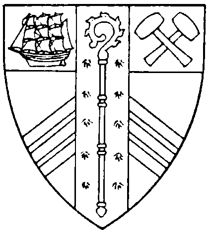
West Ham County Borough. Per fesse gules and or, in a chief a ship under sail proper and two hammers in saltire of the second, in base three chevronels of the first, over all a pale ermine thereon a crosier erect also of the second.
The land rises from the Thames to a height of about 50 ft. on Wanstead Flats. Beside the Thames and the Lea are extensive alluvial marshes; elsewhere the soil is valley gravel. An inlet of the Thames, called Ham creek, formed part of the boundary with East Ham until it was occluded in the later 19th century. (fn. 6) More than half the land in the parish, in the south and west, lay below the level of ordinary spring tides. From early times those marshes were protected by embankments and drainage ditches. (fn. 7) During the past hundred years, in the course of building development, land levels have been raised in some parts of the low-lying areas by means of rubbish tipping, (fn. 8) while the open drainage ditches have been replaced by piped sewers. (fn. 9) The topography of that part of the parish was also much affected by the building, on the Thames, of the Royal Victoria Dock (1850–5) and the adjoining Royal Albert Dock (1875–80). The river Lea, as it enters the parish from the north-west, divides into several branches, of which the westernmost is the main channel of the Lea and the easternmost the Channelsea river. The channels pass under Stratford High Street and converge again at the Three Mills, below which the Lea, as Bow creek, flows down to the Thames. The ancient pattern of the channels was greatly altered by a flood relief scheme carried out in 1931–5. (fn. 10)
THE GROWTH OF WEST HAM.
Until the later 12th century references to Ham ('low-lying pasture') do not distinguish between East and West Ham, and cannot, therefore, be interpreted precisely. (fn. 11) In 1086 the manor of (West) Ham, with a recorded population of 130, was by contemporary standards a large village. (fn. 12) Until the 19th century West Ham remained largely rural, though more populous than its Essex neighbours. In 1327, 101 persons in the parish were assessed to the lay subsidy, the largest number in Becontree hundred except for Barking. (fn. 13) In 1381 there were 240 poll-tax payers in the parish, (fn. 14) and in the fiscal year 1523–4 238 paid the lay subsidy. (fn. 15) By 1670 West Ham contained some 415 houses, (fn. 16) but any estimate of the population at that date would have to take into account the Great Plague, which had killed 160 there between July 1665 and May 1666. (fn. 17) About 1740 the number of householders was estimated at 570. (fn. 18) In 1801 the population of West Ham was 6,485. (fn. 19) It rose steadily to 12,738 in 1841, and then began a phenomenal growth, which was especially rapid between 1871 and 1901, when over 204,000 were added. By 1911, with 289,030 inhabitants, West Ham was seventh in size among English county boroughs. The new population had all been crowded within the boundaries of the ancient parish. There was little room for further growth, and the population of 300,860 in 1921 proved to be the highest census figure. A slight decline after that was greatly accelerated by the Second World War, when heavy bombing destroyed many houses and forced large-scale evacuation. The population of the borough was 170,993 in 1951 and 157,367 in 1961. Since the Second World War many overseas immigrants, mainly from the Commonwealth, India, and Pakistan, have settled in West Ham. In 1961 the resident population included 5,383 born outside the British Isles, or 3.4 per cent of the total.
Little is known in detail of the pattern of settlement before the 16th century. The Domesday manor of (West) Ham, like those in neighbouring parishes to the east, lay on the gravel terraces above the marshes, with the forest immediately to the north. (fn. 20) Robert Gernon's section of it was possibly centred on West Ham village, about ½ m. east of the Channelsea river, where by the 12th century the parish church was in existence. Ranulph Peverel's section became known in the 12th century as Sudbury ('southern manor'). Sudbury, a lost name, was in the Plaistow area. In the 13th century part of it, with other lands, became the manor of Bretts, the manor-house of which was in Plaistow village. About ½ m. north and west of West Ham village was Stratford, often called Stratford Langthorne. The 'tall thorn' existed as a physical feature in 958, while Stratford, where the Roman road from London to Colchester crossed the river Lea, was first recorded as a place-name between 1066 and 1087. (fn. 21) The Roman crossing was probably at Old Ford at Bethnal Green (Mdx.), (fn. 22) and that route remained in use until early in the 12th century, when Maud (d. 1118), queen of Henry I, built Bow and Channelsea Bridges, linked by a causeway, to carry the main road over the Lea and the Channelsea, about a mile south-east of Old Ford. (fn. 23) Bow Bridge was the lowest bridge over the Lea, and remained so until the 19th century. Along the road, on each side of the bridge, grew up the villages of Stratford Bow (Mdx.) and Stratford Langthorne. (fn. 24) In 1135 William de Montfitchet, successor to Robert Gernon, founded the Cistercian abbey of Stratford Langthorne about ½ m. south of that road. (fn. 25) Among the abbey's earliest endowments was Woodgrange, an outlying farm on the edge of the forest, first mentioned in 1189. (fn. 26) Stratford became a rich and important house, often visited by royalty, especially in the 13th and 14th centuries, (fn. 27) and probably used as an administrative centre for south-west Essex. (fn. 28) It steadily enlarged its estates in West Ham, and by the 15th century controlled most of the parish. The abbey precincts, beside the Channelsea, included a few industrial buildings and private dwellings as well as the conventual buildings; but the Cistercian tradition of isolation was not without effect there, for Stratford Abbey, unlike those of Barking and Waltham Holy Cross, did not attract settlement outside its walls.
Two early 16th century rentals of the abbey's land provide much topographical information about West Ham. (fn. 29) The main settlements were in Church Street (West Ham village), Stratford, and Plaistow. Plaistow first appears in records in 1414. (fn. 30) Its name, and the shape of the old village, suggest settlement around a village green or place of 'play'. The rentals also contain a few references to Upton, in the east of the parish, but, though that name had been recorded as early as the 13th century, (fn. 31) there was no substantial settlement there. Stratford, Plaistow, and Upton are still well-known names, but one hamlet often mentioned in the rentals has left no trace on modern maps. That was Hook End, which lay about a mile south-east of Plaistow village, at the end of Greengate Street. There are occasional references to Hook End down to the 19th century, and as late as 1869 the north end of the present Tunmarsh Lane was known as Hook End Lane. (fn. 32)
Saxton's (1576) and Norden's (1594) maps both mark West Ham, Stratford Langthorne, and the bridges over the Lea. Norden also marks Woodgrange, and shows the Ilford-London road, joined at Stratford by the road leading north to Woodford and Dunmow. West Ham's minor roads do not appear on any surviving map before the 18th century.
From the 16th to the early 19th century West Ham was increasingly favoured as a place of residence or holiday resort by wealthy merchants and professional men working in London. (fn. 33) By the early 17th century the parish had been divided into wards: Church Street (including West Ham village), Stratford, Plaistow, and Upton; Upton ward was later merged in Church Street. In 1670 the houses of the parish were distributed among the wards as follows: 179 in Stratford, 103 in Church Street, 108 in Plaistow, and 25 in Upton. (fn. 34)
About 1700 there was a spurt of growth at Stratford. Defoe reported in 1722, no doubt with exaggeration, that it had more than doubled in size during the previous 20 or 30 years. He also stated that two new hamlets had grown up on the forest side of the village, namely Maryland Point, on the Woodford Road, and the Gravel Pits on the Ilford Road. (fn. 35) Maryland Point is shown on a map of 1696. (fn. 36) The first house there is said to have been built by a rich merchant who returned to England from Maryland. (fn. 37) Various attempts have been made to identify the merchant. The most likely candidate is Richard Lee (d. 1664), who emigrated to Virginia about 1640. (fn. 38) Among his estates was land on the Maryland side of the Potomac river, near a place known in 1676 as Maryland Point. (fn. 39) He returned to England in 1658, and in 1658–9 bought properties at Stratford Langthorne. In 1662 he had a house there with 9 hearths. (fn. 40) Whatever its origin, Maryland Point became a permanent place-name in West Ham. The Gravel Pits, the other new hamlet mentioned by Defoe, is not named on any map. (fn. 41) It was probably the settlement, north of Stratford Common (or Green), shown on later maps.
The growth of Stratford in the early 18th century emphasizes the importance of its position at the gateway to London. In the 17th century this had sometimes been literally true. A turnpike gate, at the Stratford end of Bow Bridge, was seized by the Royalists in 1648. (fn. 42) In 1681, at another time of national unrest, quarter sessions set up a turnpike in Stratford High Street, and another at the Abbey Mill in Abbey Lane, to prevent the escape of criminals from London. (fn. 43) The Abbey Mill gate was rebuilt by the county in 1698. (fn. 44) In the mid 18th century the parish vestry was employing a gatekeeper there. (fn. 45) By the later 19th century it had become a private toll-gate, attached to the Abbey Mill. (fn. 46) Tolls were still being collected in 1933 (fn. 47) but appear to have ceased soon after. The later history of the other turnpike set up in 1681 is not known, but that also may have become a toll-gate. In 1721 the main road through Stratford was taken over by the Middlesex and Essex turnpike trust, whose toll-gate in High Street was about 500 yd. west of Channelsea Bridge. (fn. 48) The trust, which survived until 1866, received composition payments from the landowners upon whom, as successors in title to Stratford Abbey, had fallen the obligation to maintain Queen Maud's bridges and causeway. (fn. 49)
The roads and settlements of the whole parish are shown, though not all are named, on Rocque's map (1744–6). (fn. 50) The roads of Plaistow ward also appear, without names, on John James's map (1742), which is part of a detailed survey including earlier information and later annotations up to the 1780s. (fn. 51) By 1744–6 development was already fairly continuous along the main road at Stratford from Charles (Channelsea) Bridge as far as the present Broadway and the Grove, with outlying hamlets near Bow Bridge, at Maryland Point, and on the north side of Stratford common. Stratford common (or green), about 6 a. in extent, was the site later used for West Ham's technical college. (fn. 52) It was inclosed by the West Ham manor court c. 1807–20 in a series of copyhold grants. (fn. 53) In the 18th century the name Stratford green was also used for the site now occupied by St. John's church, Stratford, (fn. 54) and it seems likely that those two sites were the eastern and western ends of what had once been a much larger green. Stratford green was also called Gallows green, probably from the gallows set up in the 13th century by Richard de Montfitchet. (fn. 55) It is thought to be the place where the Protestant martyrs were burnt in 1555–6. (fn. 56) Rocque also shows Forest Lane, Woodgrange Road, and Water Lane. West Ham village clustered round the church, with a few houses along Stratford (now West Ham) Lane to the north, and along Abbey Lane (now Abbey Road) which ran south-west to West Ham abbey. From the abbey a lane ran south through Abbey marsh. It was known as Marsh Lane until the later 19th century, when it became part of Manor Road. Ass House (now Vicarage) Lane and Church Street are named. In naming the former the cartographer may have been misled by a rustic informant: the form Jackass Lane, also recorded in the 18th century, seems more authentic. (fn. 57)
In the 1740s Plaistow village appears to have been the largest settlement in the parish. Its centre was roughly triangular, comprising the present High Street, North Street, and Richmond Street. There were also houses along Balaam Street to the southwest and Greengate Street to the south-east. High Street was known in the 16th century and later as Cordwainer Street, from the leather trade carried on there. (fn. 58) Balaam Street, first recorded in 1364–5, (fn. 59) took its name from the Balun family, who lived at Plaistow as early as 1183. (fn. 60) South of the village, in the 1740s, were several lanes running through the marshes towards the Thames. New Barn Street, the continuation of Balaam Street, was first recorded in 1527. (fn. 61) It took its name from New Barns farm, the ancient rectorial glebe of West Ham. (fn. 62) The present Butchers Road and Freemasons Road, which fork south from New Barn Street, are shown by both Rocque and James. Freemasons Road was then called Green Lane. (fn. 63) During the 19th century it was known for a time as Dirty Lane. (fn. 64) Butchers Road was formerly known as Butchers Hedge Lane. (fn. 65) West of it was a lane running down to Bow creek. In the earlier 19th century the whole of that was called Forty Acre Lane, but as a result of modern changes the name has been retained only for a short stretch of road. (fn. 66) Prince Regent Lane, which runs south from Greengate Street, was known in 1667 as Trinity Marsh Lane. (fn. 67)
Rocque and James also show Chargeable Lane and Star Lane, running west from Balaam Street and Forty Acre Lane respectively. Chargeable Lane led to a field called Shillingshaw, or Chargeables, the owner of which was bound to contribute to the maintenance of Chargeable Wall at Lea Mouth. (fn. 68) Star Lane led to Star field. (fn. 69) Running east from Plaistow village, above the marshes, were two roads named by Rocque: Brewers Lane and Pursey Lane. Brewers Lane was roughly equivalent to the part of Barking Road between the Abbey Arms and Green Street. Pursey (or Palsey, or Purles Hill) Lane was on the line of the present St. Mary's and Queen's Roads. (fn. 70) Running north from the village was the road to Upton, now Pelly Road and Upton Lane. Rocque also shows Portway, linking Upton with West Ham village, and the present Plashet Road, running from Upton to East Ham. Portway ('town way') is recorded from the 16th century, (fn. 71) Plashet Road was previously called Plashet Lane. (fn. 72) The junction of Upton Lane, Portway, and Plashet Lane was known, at least from the 16th century, as Upton Cross. (fn. 73) Around and to the north of the Cross were several country houses, including Ham House in its park (now West Ham Park). Green Street, which formed part of the boundary with East Ham, was the southern end of the modern road of that name; the northern end was formerly Gipsy Lane.
In the later 18th century there was considerable further development, including some industry, (fn. 74) in the northern wards of the parish, but comparatively little in Plaistow ward. Between 1742 and c. 1780 the number of houses in Plaistow rose only from 152 to 159. (fn. 75) There are no corresponding figures for the other wards, but the trend can be seen from rateable values. In 1742 the rateable value of Plaistow was £3,800, compared with £3,700 for Stratford, and £3,500 for Church Street (including Upton). (fn. 76) In 1788–9 the values were: Stratford £7,500, Church Street £7,300, Plaistow £4,900, and in 1818–19: Stratford £12,600, Church Street £11,300, Plaistow £6,800. (fn. 77) These figures show the increasing influence of London upon the northern wards, and the relative isolation of Plaistow. Plaistow was at last provided with a main road, by-passing Stratford, about 1812, when the Commercial Road turnpike trust built New (now Barking) Road from the East India Docks, across the Plaistow marshes, to East Ham and Barking, with an iron bridge over the Lea by Bow creek, (fn. 78) and a toll-gate in Barking Road, near the bridge. (fn. 79) That road did not immediately influence local settlement, (fn. 80) but it eventually became the main thoroughfare and shopping centre of south West Ham. It was controlled by the Commercial Road trust until the trust expired in 1871. (fn. 81)
By the early 19th century West Ham was already a populous parish, and with the coming of the railways (fn. 82) it grew rapidly. Stratford became a junction on the Eastern Counties Railway (1839–40). In 1847 the E.C.R. transferred its main works, previously at Romford, to a site north-east of the junction. Beside the works the company built Hudson Town, named after its chairman, George Hudson 'the railway king'. It was stated in 1848 that 100 houses had already been completed there and that another 150 were being planned. (fn. 83) By 1855 Hudson Town extended east from Leyton Road to Leytonstone Road, and north from Windmill Lane to Maryland Road. (fn. 84) A little later it became known as Stratford New Town. (fn. 85) During the 1860s, as further building took place, that name was extended to include also the area between Maryland Road and the northern boundary of the parish. (fn. 86)
The growth of south West Ham also began in the 1840s. About 1843 the North Woolwich Land Co. bought and began to develop much of Plaistow marshes, between Barking Road and the Thames. (fn. 87) Prominent in that syndicate was George P. Bidder (1806–78), a civil engineer whose remarkable career had started in childhood as a 'calculating phenomenon.' (fn. 88) Bidder, more any other person, was the maker of modern West Ham. He was the projector of the Eastern Counties and Thames Junction Railway, opened in 1846–7, from Stratford to North Woolwich, with an intermediate station at Barking Road. (fn. 89) The line was intended mainly to carry coal from the Thames. Coal did indeed form a large part of the early traffic, but the line immediately gave rise also to manufacturing industries at Bow creek, including the shipyard of C. J. Mare & Co. (1846), later the Thames Ironworks and Shipbuilding Co. (fn. 90) Soon after the completion of the railway, work also started on the Victoria Dock, of which Bidder was the chief designer.
The workers in the new enterprises were housed in two townships near Barking Road station. (fn. 91) One of these was Canning Town, a name of unknown origin first applied to the small area north of Barking Road, between the Lea and the railway. In 1851 it comprised some 60 houses in Stephenson Street, Wharf Street, and Wharf Place. (fn. 92) The other township grew up south and east of Barking Road station, close to Mare's shipyard. In 1851 it was called Plaistow New Town, which contained about 80 houses, mostly in or near Victoria Dock Road. (fn. 93) By 1855 it had become known as Hallsville, apparently after the owner of some of the houses. (fn. 94) It then extended as far east as Rathbone Street and Roscoe Street (now Ruscoe Road). (fn. 95) In the course of the next 10 or 15 years the name Hallsville dropped out of use, except for a road, and the name Canning Town came to be used for the whole built-up area, south as well as north of Barking Road station. (fn. 96) The opening of the railway to North Woolwich was soon followed also by development along the Thames bank. About 1852 the rubber firm of S. W. Silver & Co. opened a factory near Ham creek, just inside the parish and thus founded Silvertown. (fn. 97) A few workers' houses were built beside the factory, but the development of the area was slow at first.
By the 1850s new building was going on in several other parts of the parish, mostly following the railways. In the north, at Forest Gate, development started about 1855, on the Gurney and Dames estates, west and north of the E.C.R. station. (fn. 98) In the centre new streets had been laid out north and south-west of Plaistow village by 1855, (fn. 99) and development there was stimulated by the opening, in 1858, of the London, Tilbury & Southend Railway's loop line to Barking, with a station at Plaistow Road. There was also new building immediately east of West Ham village. That area, which included Leabon Street, John Street, Plaistow Grove, and the north end of Plaistow Road, was known in 1855 as Rob Roy Town, a short-lived name of unknown origin. (fn. 100) At Stratford, by 1855, there had been development in two areas south of High Street. One was east of Stratford Bridge station, and included Chapel, Langthorne, and Paul Streets. The other was at Stratford Marsh, near the gasworks. (fn. 101) About then building was also starting on the Manbey estate, east of the Grove. (fn. 102)
Building continued steadily throughout the 1860s. The southern portion of the Upton 'Manor' estate, including Pelly Road, was being developed in 1866. (fn. 103) At the same time Canning Town was spreading eastwards. Among developments there were Hudson's estate, including Hudson's Road, and Ireland's estate, including Denmark Street. (fn. 104) Near those was Cherry Island, a small market-garden partly surrounded by marsh ditches. (fn. 105) There, about 1868, a speculator laid out Edwin, Bradley, and Thomas Streets, and built a number of squalid cottages which were a nuisance to the local board for many years. (fn. 106) Cherry Island was also a resort of gipsies, whose clean and orderly camp compared favourably with the cottages. (fn. 107) At Silvertown a small estate was built north of the railway about 1865, comprising Constance, Andrew, and Gray Streets. (fn. 108) At Stratford the Carpenters' Company of London began developing their estate about 1867. (fn. 109) It comprised 63 a. on the north side of High Street at Stratford marsh, which the company had owned since the 18th century. The Carpenters leased the land to builders who, during the next 20 years, erected factories, and some 600 workers' houses, in Carpenters Road and neighbouring streets. (fn. 110) South of High Street, in Sugar House Lane, the Reynolds estate was by 1862 being covered with factories. (fn. 111)
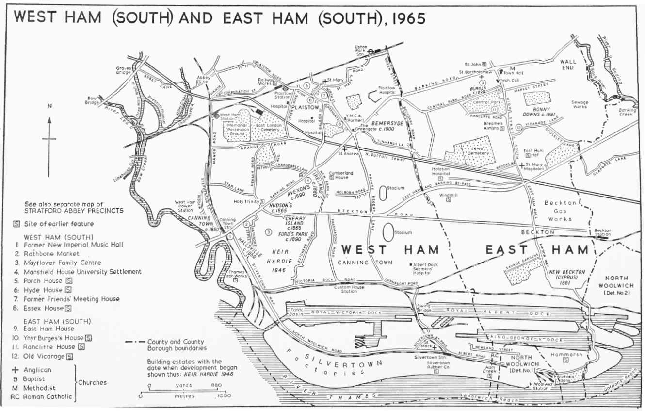
WEST HAM (SOUTH) AND EAST HAM (SOUTH), 1965
After 1870 West Ham grew remarkably fast, and by the end of the century had become a great seaport and manufacturing town, with a northern fringe occupied by professional men and clerks working in London. Between 1871 and 1901 over 30,000 houses were built. (fn. 112) The peak building periods were about 1877–83 and 1897–1901. (fn. 113) In 1881–2 2,400 new plans were deposited with the local board, compared with 218 in 1870. (fn. 114) That was exceptional, but between 1886 and 1897 over 14,000 plans were deposited, and 13,000 buildings erected. (fn. 115) Most of the new building took place to the east of the older districts, but there was also a good deal of in-filling, especially in the areas west of old Plaistow, and north of Barking Road station. (fn. 116) Many of the new houses were on estates where building had started before 1870. (fn. 117) Among important new developments in the north were the Hamfrith(West Ham Hall) and Woodgrange estates, both at Forest Gate, east of Woodgrange Road. The Hamfrith estate, where development started about 1872, was bounded on the east by Manor Park cemetery, and included Godwin and Sebert Roads. (fn. 118) The Woodgrange estate, comprising 110 a. and extending into East Ham, lay between Romford Road and the railway, (fn. 119) Between 1877 and 1892 1,160 good quality houses were built there, mainly in Hampton, Osborne, Claremont, Balmoral, Windsor, and Romford Roads. (fn. 120) The development was started by Thomas Corbett, and continued by his son A. Cameron Corbett, later Lord Rowallan, whose work at Ilford has been described elsewhere. (fn. 121) The area south of Forest Gate was also growing fast. West Ham Park, dedicated to the public in 1874, (fn. 122) was an amenity likely to attract middle-class residents. The surrounding district was developed accordingly, (fn. 123) and the word 'park' was included in several of the local place-names. The area east of the park, previously occupied by country houses of wealthy Quakers, (fn. 124) was developed in the 1880s as the suburb of Upton Park. (fn. 125) The Matthews Park estate, comprising five roads north of the park, was developed in the 1890s. (fn. 126) The large Shirley House estate, built about the same time, lay in the angle between West Ham Lane and Romford Road. (fn. 127)
In the south of the borough, between 1871 and 1901, the building of houses followed industrial expansion, notably the completion of the Royal Albert Dock and the building of large new factories at Silvertown. West Ham was greatly affected also by the building of Beckton gasworks in East Ham, to which a railway, branching from the North Woolwich line, had been opened in 1874. During the 1880s there was much building in the Custom House district of Canning Town. (fn. 128) Developments in the 1890s included the Fords Park estate, which lay south of Beckton Road, (fn. 129) and the Avenon's charity estate, between Barking Road and Beckton Road. (fn. 130)
By 1901 most of the borough had been built up. (fn. 131) The development of the Bemersyde estate, occupying the triangle between Barking Road, Boundary Road, and Tunmarsh Lane, was completed about 1906. (fn. 132) The name Bemersyde was given to it by Henry Haig (1818–97), who acquired it about 1870. He was a distant descendant of an ancient Scottish family, the Haigs of Bemersyde (Roxburgh). (fn. 133) The estate was developed by his son Neil W. Haig (1868– 1926). Its development coincided with the borough's first council houses, some 400 of which were built at Stratford, Plaistow, and Canning Town between 1899 and 1905. (fn. 134) By 1908 the only part of the borough which had still not been built upon was that east of Prince Regent Lane. (fn. 135) There was a little later building even there, (fn. 136) but some of that area still remains open.
Between 1918 and 1939 the borough council built about 1,200 more houses, under slum clearance and road improvement schemes. Some 600 more, built by the Ministry of Transport under the Silvertown Way scheme, were transferred to the council. There was little other building. During the Second World War some 14,000 houses, over a quarter of those in the borough, were destroyed. The damage was heaviest in the south, especially in Tidal Basin ward, which had contained some of the worst slums. Between 1945 and 1965 the borough council carried out redevelopment and slum clearance schemes in many areas, involving the building of over 9,500 dwellings, of which 8,000 were permanent. The main project was the Keir Hardie estate, north of the Royal Victoria Dock. Other large schemes were carried out at Bidder Street, Canning Town, Grange Road, Plaistow, Church Street, West Ham, Rokeby Street and Carpenters Road, Stratford, and at Stratford New Town.
Modern development has preserved the lines of most of West Ham's old roads, though, as shown above, some of the names have been changed. In the north of the borough the main thoroughfares are, in the main, the old roads widened and improved. In the south, however, some thoroughfares are entirely modern. The North Woolwich Land Co., when it began developing Plaistow Marshes in the 1840s, built North Woolwich Road from Canning Town to North Woolwich, parallel with the railway. (fn. 137) When the Victoria Dock was built shortly after, its entrance cut across that road and railway. The Eastern Counties Railway, which had acquired the North Woolwich branch, then built a new loop line to North Woolwich, skirting the north side of the dock and crossing its eastern tip by a swing bridge. A tunnel was later built under the dock for the loop. The old North Woolwich line, retained for goods traffic only, was carried over the dock entrance on a swing bridge only 23 ft. wide, which it shared, like a tram line, with the North Woolwich Road. (fn. 138) Along the north side of the dock, beside the railway, the North Woolwich Land Co. built Liliput Road, running from Victoria Dock Road, at Hoy Street, west to Custom House station. When the Albert Dock was built, Liliput Road was extended and linked with a new public road, Connaught Road, which ran parallel with the railway down to Silvertown station, passing between the two docks on the swing bridge. Traffic on both the upper and the lower roads to Silvertown was subject to long delays at the swing bridges and at several level crossings. Vehicles, though not pedestrians, were also obliged to pay tolls to the North Woolwich Land Co. About 1866 the local board took over the original part of Liliput Road, but the company retained control of North Woolwich Road, and of the Liliput Road extension when that was built. As Silvertown grew, the company came to draw a large income from tolls, while spending little on the repair of its roads. In 1884, under pressure from the local industrialists, the local board secured statutory powers to acquire North Woolwich Road and the Liliput Road extension. (fn. 139) It completed the purchase in 1886, and immediately made up North Woolwich Road. (fn. 140) In 1887 Liliput Road was renamed as part of Victoria Dock Road. (fn. 141)
The difficulties caused by the level crossings and the swing bridges became increasingly serious until 1934, when Silvertown Way was completed. (fn. 142) That new road, linking Barking Road and North Woolwich Road, was carried over Victoria Dock Road, the North Woolwich railway, and the dock entrance by a viaduct and bridges. The scheme also included a new road bridge over the Lea at Canning Town, the widening of Barking Road at its west end, and a new road, Silvertown By-Pass (1935), carrying North Woolwich Road over the railway north of Silvertown station.
Beckton Road, linking Canning Town with the new gasworks at Beckton, was built about 1870. (fn. 143) The section of it east of Prince Regent Lane was a private road belonging to the Gas Light and Coke Co., which levied tolls there until 1931, when the road, so far as it lay in West Ham, was bought by the borough council. (fn. 144) The East Ham and Barking By-Pass, which diverges from Beckton Road at Prince Regent Lane, was opened in 1928 and given a second carriage-way in 1959. (fn. 145)
The need for a direct thoroughfare from the western side of Canning Town to Stratford was soon recognized, but has never been fully met. The local board discussed it as early as 1862, and in 1879 approved a scheme for a 50-ft. road running from Barking Road, opposite Rathbone Street, north to join Bridge Road. (fn. 146) That was not carried out, but a partial substitute was provided in 1889, when the Great Eastern Railway diverted and widened Manor Road during improvements to the North Woolwich branch line. (fn. 147)
In the north of the borough the most notable road works have been at High Street, Stratford, which during the past forty years has been altered almost beyond recognition. The High Street Improvement Scheme, for which the borough council secured statutory powers in 1930, was closely linked with the River Lee Flood Relief Scheme. (fn. 148) It was delayed by the Second World War, but was completed in 1964, providing a dual carriage-way from Station Street to Bow Bridge. Under a new scheme, completed in 1967, a flyover was built at Bow Bridge to carry east-west traffic.
Communications between Stratford and Plaistow have been improved by the construction of New Plaistow Road, completed in 1959, which links West Ham Lane and Plaistow Road, by-passing West Ham village. (fn. 149) That was part of a redevelopment scheme which also included the widening of Plaistow Road and High Street.
It is relevant to include the northern outfall sewer in an account of modern roads, because the flattopped embankment which carries it is laid out as a public footpath. The sewer enters West Ham near Marshgate Lane, Stratford, and runs south-east, at a commanding height, to its outfall on the Thames by Barking creek. It was built by the Metropolitan board of works in 1868, to drain the northern half of London. (fn. 150)
The origins of many of West Ham's minor modern street names have been the subject of a special study. (fn. 151)