A History of the County of Essex: Volume 9, the Borough of Colchester. Originally published by Victoria County History, London, 1994.
This free content was digitised by double rekeying. All rights reserved.
'Outlying parts of the Liberty: Greenstead', in A History of the County of Essex: Volume 9, the Borough of Colchester, (London, 1994) pp. 382-390. British History Online https://www.british-history.ac.uk/vch/essex/vol9/pp382-390 [accessed 26 April 2024]
In this section
GREENSTEAD
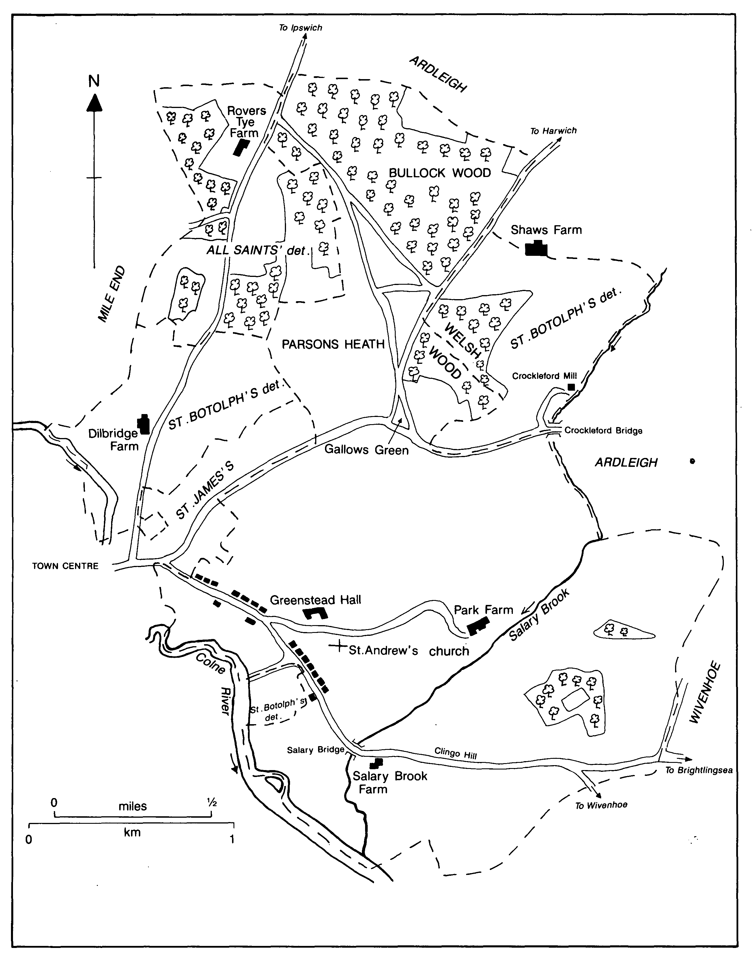
Greenstead c. 1838
The ancient parish of Greenstead comprised 1,501 a. (607 ha.) on the east of the built-up area of Colchester. (fn. 1) Greenstead was originally a compact estate, but a quarter of it passed to St. Botolph's priory, Colchester, and thus became detached parts of St. Botolph's parish. Earlier the parish was probably bounded on the south-west by the Colne, on the west by Mile End, on the north by woodland, and on the east for a short stretch by Salary brook, while the south-east boundary lay across Whitmore heath and Wivenhoe heath. Later the boundary excluded a detached part of St. Botolph's parish in the north-east, and another on the west. Much of the parish lies at over 30 metres, reaching 40 metres on Clingo hill, but the land falls gradually to c. 5 metres by the river Colne and more sharply to Salary brook which bisects the main part of the parish. (fn. 2) The soil is mostly glacial gravel with some alluvium along the river valleys; a band of London clay runs from south-west to north-east and there is some glacial loam in the east. (fn. 3) Much of the parish is good arable land, but the lower ground in the southeast is marshy, and was considered unhealthy in 1723. (fn. 4) The abbot of St. John's, Colchester, had fishponds in Greenstead in the 13th century, and before 1286 had created a park, presumably in the area of the later Park farm. (fn. 5) Wivenhoe park, landscaped in the late 18th century, extended into the south-west part of the parish. (fn. 6)
The Colchester-Harwich road, turnpiked c. 1725, crosses the north of the parish. A road, described as a lane in 1608, branches east towards Bromley. (fn. 7) The Colchester-Ipswich road runs along the parish boundary for a short distance in the north-west. In the south Greenstead Road, called Greenstead Street in 1372, is part of the Colchester-Wivenhoe road; a branch led eastwards to Greenstead Hall and church and to Park farm. (fn. 8) A road called Soleyntye was mentioned in 1498. (fn. 9) In the 17th century a road from Greenstead to the Hythe was built. (fn. 10)
Sunterforde bridge recorded in 1386, Caterford bridge in 1478, and Cunterfet bridge in 1646 appear to be different names for Salary bridge which carries the Wivenhoe road over Salary brook. (fn. 11) Crockleford bridge, which takes the Bromley road over Salary brook, was a ford in 1206; by 1586 there was a bridge, perhaps a footbridge, there. (fn. 12) Dilbridge farm seems to have taken its name from a bridge over the Colne, perhaps near the end of Land Lane where signs of an old ford were apparently still visible in the early 20th century. (fn. 13)
The railway to Ipswich across the north of the parish was opened in 1846 and the Tendring Hundred railway across the south in the 1860s. (fn. 14) There was a sub-post office by 1866, and by 1908 there were two, one in Greenstead Road and one at Parson's Heath. (fn. 15)
In the Roman period there may have been one or two villas in the area. (fn. 16) An estate which became Greenstead manor existed in the mid 10th century. By 1066 the settlement was well established, with at least four households in addition to the two servi who worked the manorial demesne, and had its own church. (fn. 17) Thirteen householders were assessed for subsidy in 1296, compared with 7 in Mile End, and 16 in Lexden; William of Greenstead was the most highly taxed inhabitant. (fn. 18) Members of the Northen family were substantial tenants of Greenstead manor in the 15th and 16th centuries. Thomas Northen was the wealthiest man in the parish in 1523 when 24 were assessed, more than in West Donyland and Mile End, but fewer than in Lexden. (fn. 19) There were 73 households in 1671, of which 44 were exempt from hearth tax. (fn. 20) In 1692 there were 107 adults rated to the poll tax. There were significantly more burials than baptisms in the period 1701-31, and by 1768 there were only 26 houses in the parish, many on the road to the Hythe having been demolished. The number of houses increased to 35 in 1790, and in the following decade there were only two thirds as many burials as baptisms. (fn. 21)
The population increased rapidly from 309 in 1801 to 598 in 1831, then more slowly to 789 in 1861. There was a slight decline to 752 in 1881 before the population rose again to 1,162 by 1901. (fn. 22) The number of inhabited houses increased from 118 in 1821 to 161 in 1851 and 242 in 1901. (fn. 23)
Greenstead was for long a sparsely populated, agricultural parish, with the houses concentrated in the south-east nearest Colchester town. (fn. 24) From c. 1795 another focus developed around Parson's heath in the north, as parts of the former manorial waste on Gallow green were sold in small plots. (fn. 25) By 1900 new houses were beginning to fill the gaps along the Greenstead road near the Hythe, and the south-east corner of the parish was increasingly drawn within the compass of the town. Most of Greenstead, however, remained a predominantly agricultural parish, rural rather than suburban, until the mid 20th century. (fn. 26)
A charity house, apparently near Clingo hill, was recorded in 1435. It may have been an unendowed almshouse or hospital, or it may simply have been owned by St. Mary Magdalen's hospital. (fn. 27) The few buildings from before 1800 which survived in 1990 were in Greenstead Road except for Salary Brook Farm, a timberframed house of the late 16th or early 17th century. (fn. 28)
MANORS AND OTHER ESTATES.
Ealdorman Aelfgar held an estate at Greenstead which he and his daughters devised to a religious house at Stoke, probably Stoke by Nayland (Suff.). (fn. 29) GREENSTEAD manor, presumably the same estate, was held in 1066 by Godric, a free man. On his death it was divided between his four sons, and by 1086 half of it was in the king's hands while Eustace of Boulogne and John son of Waleram each held a quarter. (fn. 30) Eustace's quarter seems to have passed to St. Botolph's priory, of which he was a benefactor, and to have been merged with the priory's neighbouring manors of Dilbridge and Shaws. (fn. 31) The remaining three quarters of Greenstead passed to Eudes the sewer (dapifer), the king's moiety presumably with the rest of the royal demesne in Colchester, John son of Waleram's quarter with his other Colchester land which Eudes had acquired by 1119. (fn. 32) Eudes apparently gave Greenstead to St. John's abbey, Colchester, but on his death in 1120 it was seized by William of St. Clare. William, with the consent of his brother Hamon of St. Clare and Hamon's son and heir Hubert, restored Greenstead to the abbey between 1141 and 1151. (fn. 33) The abbey's estate in Greenstead was enlarged by several grants in the 12th, 13th, and 14th centuries, notably by Hubert of St. Clare between 1148 and 1154, and by William Brome, who gave a total of c. 75 a. in 1336. (fn. 34)
St. John's retained Greenstead until the Dissolution, when it was granted to Thomas Cromwell, Lord Cromwell. (fn. 35) On his attainder in 1540 the estate escheated to the Crown, and was granted in 1548 to Princess, later Queen, Mary. (fn. 36) In 1557 Mary granted it to Bernard Hampton, a clerk of the Privy Council, who conveyed it in 1561 to Lawrence Cockson, a London haberdasher, who conveyed it in 1563 to Sir Thomas Lucas. (fn. 37) The Lucas family had already acquired Mile End manor in 1544 and Bullock and Soane woods in 1546. (fn. 38) From Sir Thomas (d. 1611) the manor passed to his son Sir Thomas (d. 1625) and grandson John Lucas, Baron Lucas of Shenfield. Lord Lucas was succeeded by his daughter Mary, Baroness Lucas of Crudwell (d. 1702), who married Anthony Grey, earl of Kent. (fn. 39) The manor then descended with the barony of Lucas of Crudwell until 1917 when it was sold. (fn. 40) From 1918 to 1931 the manor was held by C. E. Gooch of Wivenhoe Park, but thereafter manorial rights seem to have lapsed. (fn. 41)
Greenstead Hall, where courts were held, was a manor house. (fn. 42) The building, demolished c. 1967, appears to have been a farmhouse of the 18th and 19th centuries. (fn. 43)
The farmstead of SHAWS, called a manor from 1542, derived from the holding of John at Shaw in Greenstead, recorded in 1296. (fn. 44) It was held of St. Botolph's priory in 1311, and passed into the priory's possession between 1318 and 1351, perhaps on the death of John at Shaw who was last recorded in 1337. (fn. 45) By 1542 Shaws, on the boundary between Colchester and Ardleigh, was the centre of an extensive estate comprising land and rents in St. Botolph's, All Saints', St. Giles's, St. Runwald's, St. James's, St. Peter's, St. Nicholas's, St. Leonard's, St. Mary Magdalen's, and Greenstead parishes in Colchester, and in Ardleigh, Bromley, Tendring, Little Bentley, Elmstead, and Wivenhoe, presumably acquired by St. Botolph's at different times. At the Dissolution it was granted to Sir Thomas Audley, later Lord Audley, (fn. 46) and escheated to the Crown on his death in 1545.
The Crown retained the manorial rights, but not the demesne land, until 1596, (fn. 47) and probably until c. 1626 when they were sold to George Whitmore, alderman and later lord mayor of London (d. 1654). (fn. 48) He was succeeded by his son William (d. 1678) and grandson, also William Whitmore, who died without issue in 1684. Shaws was sold with the Whitmore's other Essex manor, Wrabness, to Sir Thomas Davall, who held it in 1698. (fn. 49) On his death in 1712 it passed to his son, another Sir Thomas Davall (d. 1714), who was succeeded by his infant son Thomas (d. 1718). (fn. 50)
On the death of the last Thomas Davall Shaws passed with Wrabness to Daniel Burr, cousin and devisee under the will of the second Sir Thomas Davall. Burr sold the manor in or before 1749 to Nathaniel Garland (d. 1756), who was succeeded by his son Lewis Peak Garland (d. 1780) and by Lewis Peak's son Nathaniel (d. 1845). Nathaniel's son Edgar Wallace Garland died without issue in 1902 and was succeeded by his nephew Arthur Nathaniel Garland who was lord of the manor in 1928, by which time most of the manorial rights had been sold. (fn. 51)
The Crown granted the manorial demesne, later Shaws farm, in 1545 to William Beriff, a Colchester clothmaker, and John Multon. (fn. 52) Beriff died in 1595 in sole possession of Shaws which he left to his son, another William Beriff (d. 1628), who was succeeded by his son, also William Beriff. (fn. 53) By 1640 the farm had passed to Edmund Church. When he died in 1649, his lands were under sequestration for recusancy and Shaws does not seem to have been among those recovered by his daughters Anne and Mary. (fn. 54) By 1706 the farm belonged to William Hall; (fn. 55) he sold Shaws before 1748 to Thomas Kilham of London (d. 1753) (fn. 56) who devised it to his son Leonard. Leonard, of St. James's, Westminster, died in 1799 leaving the farm to his cousin John Roberts (d. 1820). In 1837 Roberts's widow Sarah sold Shaws to Sir Thomas Mash, the principal mortgagee. (fn. 57)
By 1425 St. Botolph's priory held a farm at DILBRIDGE north-east of the town. (fn. 58) It presumably comprised the detached portion of St. Botolph's parish there and was probably the quarter of Greenstead manor held in 1086 by Eustace of Boulogne which he, or more probably his successor another Eustace of Boulogne, gave to the priory before the second Eustace's retirement in 1125. (fn. 59) At the Dissolution the farm was granted to Sir Thomas Audley, later Lord Audley, who immediately conveyed it to John Christmas. (fn. 60) John and his son George sold it in 1552 to John Lucas, owner of Mile End manor, with which Dilbridge descended thereafter. (fn. 61) Baroness Lucas sold the farm to W. Marriage in 1917. (fn. 62)
Throwerystye, later ROVERS TYE, was recorded in 1353. (fn. 63) An estate there was bequeathed by Sir Laurence Rainsford to his son Henry in 1489. (fn. 64) In 1544 Edward Smith of Hadleigh (Suff.) and Ursula his wife sold it, with its lands and rents in All Saints', St. Botolph's, Greenstead, and Ardleigh, to John Lucas, and it became part of the Lucas estate in Mile End and Colchester. (fn. 65) In 1917 Baroness Lucas sold the farm to its occupier. (fn. 66)
The former Rovers Tye farmhouse is an early 17th-century timber-framed house with 18thcentury additions along the west side. In 1983, when it was converted into a public house, (fn. 67) major timber-framed extensions were made on the west, and a small barn which had stood to the west of the house was rebuilt at the south end.
ECONOMIC HISTORY.
In 1066 there were 4 ploughteams. In 1086 only 2 teams with 2 servi were recorded, both on the king's demesne. There were 24 a. of meadow and marsh on the king's 2 hides, and presumably an equivalent area on the remaining 2 hides. The king's hides were valued at 30s. each, compared with 20s. for the remaining 2 hides, suggesting that, although no teams were recorded in 1086, they had not gone out of cultivation and were being cultivated from other Colchester estates. (fn. 68)
There was considerable early clearance of woodland. The farm name Shaws, meaning wood or grove, suggests that it was an assart. (fn. 69) Other land was also inclosed and used for arable cultivation. (fn. 70) Rye and oats were recorded in the 14th century. (fn. 71) Some of the cleared land was used for pasture. (fn. 72) At Shaws and at Rovers Tye in 1435 pasture was overloaded with 260 sheep. (fn. 73) In the 14th century 13 of St. John's abbey's tenants holding a total of 270 a. of arable, 72 a. of wood, and 22 a. of meadow had rights of common for 348 sheep, 50 cows, and 8 pigs beside Crockleford brook and on Parson's heath and Cross heath. (fn. 74)
St. John's abbey inclosed some ancient common in the north before 1323 and planted Sowen wood, c. 220 a., later known as Soane or Bullock wood, one of the earliest examples of planted woodland in the country. In 1546 trees were still being planted in rotation on 200 a. there. Sixty acres remained in 1986. (fn. 75)
An account of the common fields in 1599 recorded 137 a. of arable and pasture and 19 a. of meadow held in severalty, and 10 a. of common meadow. (fn. 76) In the 17th century cows' milk was used for cheesemaking. (fn. 77) Shaws farm was deteriorating in 1654, but by 1706 was in cultivation. Underwood from the woods there was sold in 1712. (fn. 78)
The Lucas family owned Rovers Tye, Dilbridge, and Greenstead farms, as well as Mile End farm, from the mid 16th century. (fn. 79) In 1683 Rovers Tye, in Greenstead and other parishes, comprised 2 pasture crofts, and 8 other closes (one called Saffron field) in the detached part of All Saints' parish, probably totalling c. 80 a. as they did in 1802; there was also a meadow in Greenstead. By 1730 as much as 12 a. of waste along the Ipswich road had been inclosed as part of the farm. (fn. 80) In 1699 Dilbridge farm (mainly in St. Botolph's parish) comprised 11 a. of pasture, 9 or 10 arable fields among the burgesses' half year lands, at least 11 other arable fields, and an unspecified amount of meadow and pasture in St. Botolph's, Mile End, St. James's, and St. Nicholas's parishes; in 1711 it was by far the most valuable of the Lucases' Colchester estates. (fn. 81)
Greenstead paid £132 land tax in 1778, eleventh of the 16 Colchester parishes; the nonresident lady of the manor, whose Greenstead land was leased in five main farms, paid over half the tax. (fn. 82) In 1794 Mary Rebow was the chief of the 39 freeholders and 69 copyholders of the manor. (fn. 83) Various members of the Clay family farmed almost three quarters of the manorial estate in 1800 besides a little of their own land. (fn. 84)
In 1801 the main crops in the parish were wheat, oats, and barley; some peas, turnips, beans, and potatoes were also grown. (fn. 85) At Rovers Tye farm in 1802 fallowing had been entirely eliminated on the 50 a.-60 a. of arable by using beans, peas, turnips, clover, or grass. (fn. 86) In 1821 Shaws farm, mainly in St. Botolph's parish but extending into Ardleigh, comprised 181 a.: 178 a. arable (including c. 7 a. former meadow presumably along Crockleford brook), 1½ a. of woodland, and the site of the farmhouse and buildings. (fn. 87) In 1824 the tenants on the largely arable manorial farms followed a rotation of turnips, barley, clover, wheat, and, if manured, oats, but poor drainage in places diminished yields. (fn. 88)
By 1839 about three quarters, 726 a., of titheable land was arable. Much of the 239 a. of tithe-free land was woodland. Just over half of the parish was owned by the absentee lord of the manor, who let most of it in three main holdings, of c. 245 a., 150 a., and 83 a., and the rest mainly as small parcels of grass or arable or as cottages with gardens. (fn. 89) The only other significant landowner in the parish was the Rebow family, which in the 18th and 19th centuries was gradually consolidating its holdings in the east of the parish and in neighbouring Wivenhoe and Ardleigh. (fn. 90) In 1839 Lieut. Gen. Francis Slater Rebow of Wivenhoe Park Lodge owned almost a quarter of Greenstead parish. (fn. 91)
Agriculture remained the most important source of employment, particularly for those living in the north part of the parish. However, the farms employed a smaller proportion of the inhabitants in the later 19th century because of agricultural depression and increasing alternative employment in the town. (fn. 92)
There was very little industry in the parish before the 19th century. A tilemaker was mentioned in 1370, there was a kiln house for the manufacture of tiles at Dilbridge in 1398-9, and there was brick- and tile-making on a small scale c. 1800. (fn. 93) The 'thrower' for whom Rovers Tye was named before 1353 may have been a potter, for there is evidence of pottery-making in Mile End. (fn. 94) A grazier in 1547 was described as being also a clothier and a salter. (fn. 95) In 1810 a millwright's and engineer's business was started. Whiting was manufactured in 1842 but no longer by 1900. (fn. 96) By 1881 there were nursery gardens along Greenstead Road and an iron and brass foundry near the Hythe. (fn. 97)
LOCAL GOVERNMENT.
The abbot of St. John's held a manor court in Greenstead in the early 13th century. (fn. 98) In 1274 and 1285 he claimed gallows, tumbrel, the assize of bread and of ale, and free warren by charter of Henry III. (fn. 99) The gallows presumably stood on or near Gallow green, the triangle of land on the edge of Parson's heath. (fn. 100) Manor courts with view of frankpledge were held about three or four times a year from the 14th to the 16th century, usually including one at Whitsun and one near Christmas. An ale-taster, two constables, and one or two rent collectors were elected each year at Whitsun. (fn. 101) Between 1572 and 1602 the manor court with view of frankpledge met annually and appointed two constables and two wardens of the commons; thereafter until 1669 it met less regularly. Courts baron were held until 1931. (fn. 102)
John at Shaw unsuccessfully claimed heriot from a tenant of Shaw's manor in 1311. (fn. 103) St. Botolph's priory and its successors as lords held courts for the manor of Shaws until 1841; from 1558 they apparently held view of frankpledge, but no leet business was recorded, the courts being concerned solely with the transfer of copyhold land; pleas leading to recoveries were occasionally heard. In 1764 an Ardleigh man was presented for digging brickearth between Harwich Road and Soane wood, and from 1769 encroachments on the waste were presented and licences to inclose small pieces of waste were granted. (fn. 104)
Parish stocks were recorded in 1581. (fn. 105) Vestry records do not survive, but churchwardens and overseers were mentioned in 1685. (fn. 106) A parish workhouse was sold in 1815. (fn. 107) Annual expenditure on poor relief amounted to £152 in 1776 and c. £145 in 1783-5. (fn. 108) By 1812 it reached £322, equivalent to c. 15s. a head, and by 1820 to £487, but fell to £384 in 1821, still c. 15s. a head, just below the average for Colchester. In 1835 Greenstead became part of the Colchester poor-law union. (fn. 109)
CHURCH.
The church existed by 1066, and at the Conquest passed with the manor to Eudes the sewer who c. 1119 gave to St. John's abbey tithes of Greenstead, presumably of his demesne. (fn. 110) After Eudes's death in 1120 William of St. Clare acquired the church and between 1141 and 1151 gave it to the abbey, which kept the advowson until the Dissolution. (fn. 111) In 1540 Henry VIII granted the patronage to Thomas Cromwell, but it reverted to the Crown on his attainder and was granted in 1548 to Princess, later Queen, Mary. (fn. 112) It has remained with the Crown, from 1863 being exercised by the Lord Chancellor. (fn. 113)
The rectory was valued at 13s. 4d. in 1254 besides a pension to the abbey of 6s. (which had increased from 5s. in the late 12th century) and 4 lb. of wax a year. (fn. 114) The value of the rectory was £1 10s. c. 1291 and £5 in 1535. (fn. 115) In 1443 the living was vacant because of its poverty. (fn. 116) The abbot of St. John's retained the tithes of the manorial demesne, presumably as a result of Eudes's grant. In 1620 Thomas Lucas, lord of Greenstead manor, successfully resisted the rector, William Denman's, claim to tithe from Greenstead park, but Denman recovered tithe from two other parcels of land. (fn. 117) The house and 11 rods of glebe were worth £6 and the tithes £50 in 1650. (fn. 118) The tithes of c. 980 a. were commuted for a yearly rent of £293 in 1839, helping to raise the value of the living from £280 in 1835 to £308 10s. in 1887. (fn. 119)
The parsonage house, almost falling down in 1607, had been either repaired or replaced by the early 18th century, and was in good repair in 1790. (fn. 120) A new house was built in Greenstead Road in 1805, and enlarged c. 1898. (fn. 121) About 1962 a new house was built next to the church. (fn. 122)
Before the mid 18th century more than half of the incumbents of the poor living were pluralists. (fn. 123) Thomas Juscard, rector 1325-51, was accused in 1324 of assault, and several times between 1330 and 1351 of roaming the town at night with armed men. (fn. 124) Richard 'Father' Alvey, rector 1546-8, was one of the most influential of the early protestant preachers. Deprived of his preferments during Mary's reign, he fled abroad and was closely associated with important Marian exiles such as John Pulleyne. He was later Master of the Temple from 1560 until his death in 1584. (fn. 125) In 1575 Richard Spencer, curate from the early 1570s until 1580, had to do penance for drunkenness. (fn. 126) Robert Holmes, rector 1586-9 and rector of St. James's, Colchester, 1585-92, considered the wearing of the surplice a papal superstition. Three brief incumbencies followed until the institution of William Denman, rector 1599-1624. In 1607 the churchwardens provided a surplice for communion services only. (fn. 127) John Jarvis, rector from 1638 and rector of North Fambridge from 1631, was accused in 1644 of speaking against parliament, neglecting his cure on Sundays, swearing, frequenting alehouses, and reading his sermons from a book. He was deprived of both livings in 1646 and, at the request of the parishioners, Greenstead was served by John White, rector of St. James's. (fn. 128)
Paul Duckett, appointed in the 1650s, apparently conformed at the Restoration, but was succeeded in 1662 by John Ruting (Johannes Ruytinck), minister of the Dutch church in Colchester 1645-63 and master of Colchester grammar school 1659-62, who held the church in plurality with St. Leonard's, Colchester. (fn. 129) In 1683 the rector, Thomas Shaw, was urged to read prayers on Sunday mornings, but a later rector was still neglecting to do so in 1705. (fn. 130) Theodore Garland, rector 1706-28, was elderly and infirm by 1723 when a neighbouring clergyman served the cure. By then Garland had moved to the town because his family suffered ague and fevers at Greenstead. Benjamin Owen, resident rector 1730-54 and vicar of Abberton, performed one service on Sundays and administered communion three times a year in each parish. (fn. 131) Samuel Forster, rector 1783-97, whose brother Nathaniel was rector of All Saints', Colchester, lived in Oxford where he was registrar of the university, and employed a curate to serve Greenstead. (fn. 132)
Charles Hewitt, rector from 1797 until he died aged 96 in 1849, was rector of St. James's 1783-99 and headmaster of Colchester grammar school 1779-1806. He was serving Greenstead himself in 1815, but employed a curate in 1848. (fn. 133) Under his successor, the Evangelical Meshach Seaman, rector 1849-82, Greenstead was among the parishes which petitioned Queen Victoria c. 1850 against the restoration of the Roman Catholic hierarchy. Seaman was responsible for restoring the church in 1856-7. (fn. 134) On Census Sunday 1851 attendances of 77 in the morning and 134 in the afternoon were reported out of a population of 751. (fn. 135) In 1869 there were still only eight communion services a year. (fn. 136)
In 1920 average church attendance was 50-60 in the morning and 30-40 in the evening, mainly 'well-to-do working men'. (fn. 137) St. Edmund's church hall was built in 1966 on Greenstead housing estate to serve both as a church and as a parish hall, but in 1985 it was used mainly as a church hall. (fn. 138) In 1981 a parish room at Harwich Road was converted into St. Matthew's church and an assistant curate was appointed to serve the increasing population of Greenstead. (fn. 139) St. Andrew's maintained its Evangelical tradition in 1987.
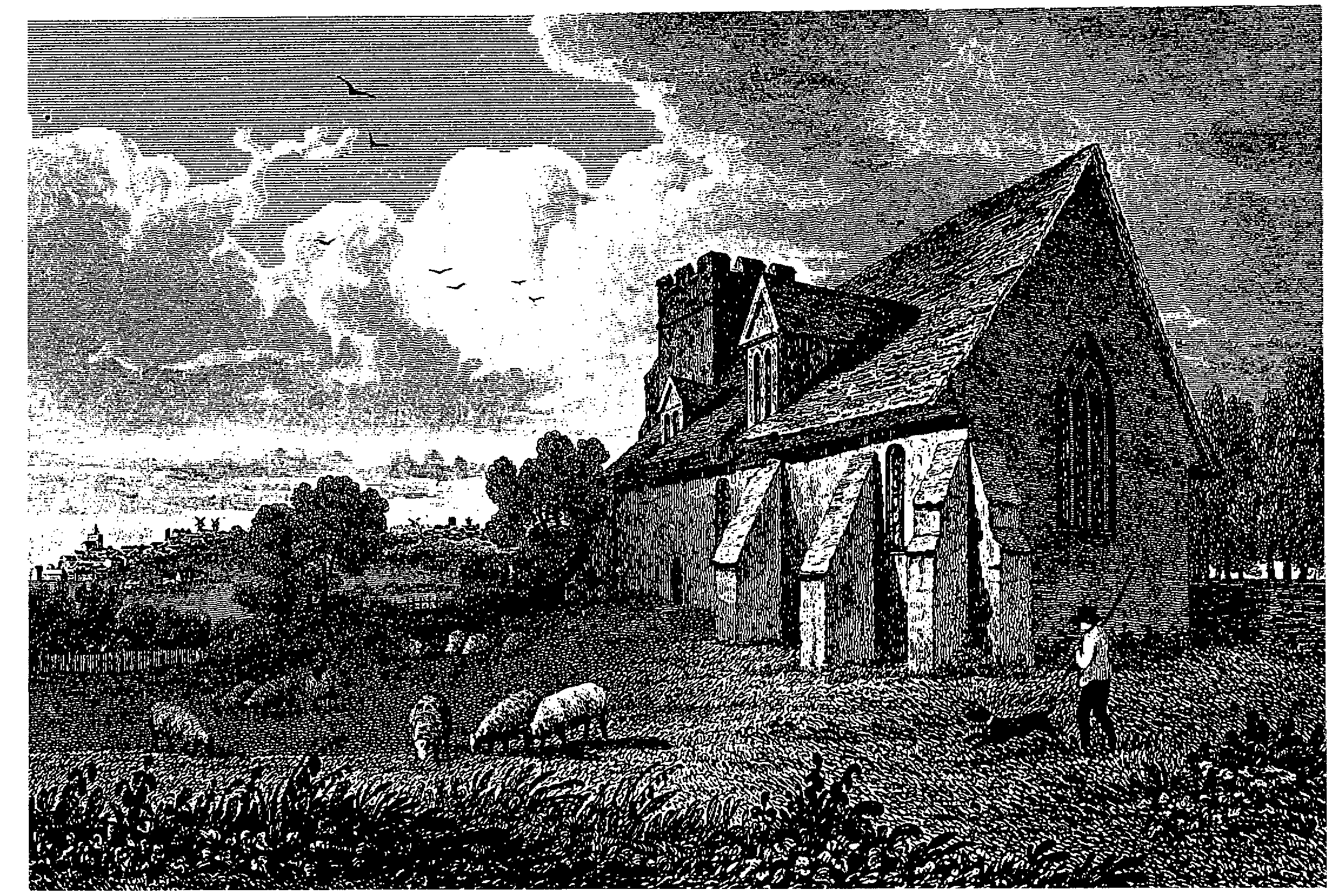
Greenstead church c. 1824
The ecclesiastical parish was reduced in 1863 when the chapelry of St. John the Evangelist was created. In 1911 a small portion of St. Botolph's parish was added to Greenstead. (fn. 140) Under the reorganization of Colchester parishes in 1953 one small portion of Greenstead parish became part of the new parish of St. Anne, and another became part of the new parish of St. James with All Saints, St. Nicholas and St. Runwald. In 1961 a small portion of St. John's parish was annexed to Greenstead. (fn. 141)
The church of ST. ANDREW, Forest Road, Greenstead, comprises a chancel and nave, structurally undivided, a south aisle running the length of the nave and chancel, a west tower, and a north porch. (fn. 142) The walls are of mixed rubble, the old work mostly being rendered, the tower is of red brick, and the roofs are of tiles and slates. The simple plan may be of 12th-century origin and the exposed north-west angle incorporates some re-used Roman brick. Until the mid 19th-century restoration two 12th-century windows survived in the chancel, which had other medieval features including a 13th-century lancet and a mid 14th-century east window with reticulated tracery. (fn. 143) Two recesses in the east wall are probably early 14th-century and a plain tomb recess in the north wall retains some medieval painting in formal imitation of stonework. The late 16th-century tower is decorated with a simple pattern in dark headers in the red brickwork.
In 1633 the church was in a poor condition, the buttress on the south side of the chancel having fallen down, and it was presumably damaged during the siege in 1648 when a parliamentary gun battery was erected in the churchyard. (fn. 144) About 1705 a buttress, presum ably the clasping buttress at the south-east angle in existence in 1824, was built to support the south wall of the chancel. The chancel and east part of the nave were refaced in the late 18th century. By 1824 the south side of the chancel had been heavily buttressed and two dormer windows had been inserted in the nave. (fn. 145)
The church was thoroughly restored in 1856- 7, largely at the expense of Thomas Philip de Grey, Earl de Grey, and J. G. Rebow, M.P. A south aisle, designed in 13th-century style by G. Sargent, was added and the interior was repewed. (fn. 146) After the earthquake of 1884 the nave ceiling was replaced and the tower repaired and stripped of its rendering. (fn. 147) Extensive repairs in 1971 included reroofing the tower and rebuilding its parapet. (fn. 148)
Victorian oak wall tablets on either side of the chancel east window contain the Lord's prayer, commandments, and creed. The Hanoverian royal arms hang above the north door. There is one bell, of 1723 by Thomas Gardiner; an earlier bell was recorded in 1607. The church plate includes a 17th-century silver cup made by R. Hutchinson of Colchester. (fn. 149)
In 1896 Francis Thomas de Grey, Lord Cowper, gave c.½ a. to extend the churchyard, (fn. 150) which was still used for burials in 1985.
The dual purpose church hall of ST. EDMUND, designed in 1966 by J. Thompson, in brick lined with wood, has a glass south wall surmounted by a cross. (fn. 151) The red brick church of ST. MATTHEW was converted from a parish room which had previously been a school. (fn. 152)
NONCONFORMITY.
A small number of Independents was recorded in 1790 and 1810. (fn. 153) Later Congregational and Baptist chapels were founded in the parish from churches in the town. (fn. 154)
EDUCATION.
Three small day schools, presumably dame schools, at which 30 children were educated at their parents' expense, were reported in 1833, but had apparently disappeared by 1841. (fn. 155) A National school, which later became Greenstead Church of England primary school, was built in Greenstead Road in 1851 at the instigation of the rector, Meshach Seaman, in a building erected by Thomas Philip de Grey, Earl de Grey, lord of the manor. (fn. 156) The site and building remained the property of de Grey's successors until they were given in trust to the rector and churchwardens in 1921. (fn. 157) At first the school was maintained solely by Seaman. (fn. 158) By 1863 it was attended by c. 100 children, and from 1866 it received annual government grants. (fn. 159) In 1874 attendance fell as new schools opened in neighbouring parishes, and in 1875, at Seaman's request, the committee of the central National school took over the management of the school. (fn. 160) In 1893, when 91 children attended, the school was enlarged by subscription to accommodate 174, and by 1899 attendance had risen to 130. (fn. 161) In 1932 the school was reorganized for juniors and infants. It was granted Controlled status in 1951 and closed in 1976. (fn. 162)
St. John's Church of England primary school originated in 1863 as a small school for 30 children, associated with St. John's district church and held in a cottage. In 1872 a new school for 90 children was built by subscription and grants on land in Ipswich Road given by Katrine de Grey, Countess Cowper. (fn. 163) It received government grants from its opening in 1873. (fn. 164) Average attendance was c. 60 in 1890, but later that year several children left to go to Kendall Road board school. In 1895 a government inspector found the school inefficient, but it survived falling numbers and frequent staff changes. Attendance rose from 52 in 1898 to 87 in 1910, (fn. 165) when the building was enlarged. In 1934 the school was reorganized for juniors and infants. It was granted Controlled status in 1952, and in 1972 moved to new buildings in Clay Lane Grove. (fn. 166)
Parson's Heath Church of England primary school originated as a National day and Sunday school for 72 children, hastily built in Greenstead Road in 1890 to forestall a British school. It received annual government grants from its foundation. (fn. 167) By 1893 it had 87 children, and in 1894 was enlarged for 121. (fn. 168) It was reorganized in 1932 for juniors and infants. (fn. 169) In 1951 the school was granted Controlled status and in 1966 it moved to a new building in Templewood Road. (fn. 170)
East Ward school, Hazelmere schools, St. Andrew's schools, and Sir Charles Lucas school are described above. (fn. 171)
CHARITIES FOR THE POOR.
None known.