A History of the County of Gloucester: Volume 10, Westbury and Whitstone Hundreds. Originally published by Victoria County History, London, 1972.
This free content was digitised by double rekeying. All rights reserved.
Kathleen Morgan, Brian S Smith, 'Frampton on Severn: Introduction', in A History of the County of Gloucester: Volume 10, Westbury and Whitstone Hundreds, ed. C R Elrington, N M Herbert, R B Pugh (London, 1972), British History Online https://www.british-history.ac.uk/vch/glos/vol10/pp139-143 [accessed 30 April 2025].
Kathleen Morgan, Brian S Smith, 'Frampton on Severn: Introduction', in A History of the County of Gloucester: Volume 10, Westbury and Whitstone Hundreds. Edited by C R Elrington, N M Herbert, R B Pugh (London, 1972), British History Online, accessed April 30, 2025, https://www.british-history.ac.uk/vch/glos/vol10/pp139-143.
Kathleen Morgan, Brian S Smith. "Frampton on Severn: Introduction". A History of the County of Gloucester: Volume 10, Westbury and Whitstone Hundreds. Ed. C R Elrington, N M Herbert, R B Pugh (London, 1972), British History Online. Web. 30 April 2025. https://www.british-history.ac.uk/vch/glos/vol10/pp139-143.
FRAMPTON ON SEVERN
FRAMPTON ON SEVERN lies 9 miles south-west of Gloucester, on a bend in the River Severn. It is widely known for its spacious village green, called Rosamund's Green after Henry II's mistress, Rosamund Clifford, a member of the family closely associated with Frampton from the 11th century to the 20th. The River Severn forms one of the six sides of the parish; the former course of the River Cam marks the south-western boundary, Wicksters brook the southern, the Gloucester-Bristol road the south-eastern, the River Frome most of the northeastern, and the Gloucester and Berkeley Canal roughly follows the north-western boundary. (fn. 1) The area of the parish, excluding river foreshore, was 2,365 a., (fn. 2) including 1 a. that was formerly a detached part of Wheatenhurst and was added to Frampton in 1882. (fn. 3) In 1935 43 a. of the parish forming a small promontory east of the Gloucester-Bristol road was transferred to Eastington. (fn. 4)
The land lies flat and low, mostly below the 50 ft. contour line, and rises to 100 ft. only at one point on the eastern boundary. It is mostly on the river clays and gravels, and was formerly drained by the streams mentioned above and by small feeders, but human works have changed the pattern. The course of the Frome has been altered at the eastern angle of the parish, by Fromebridge Mill, and also, over a longer stretch, a mile downstream. More fundamentally, the Gloucester and Berkeley Canal takes all the water that once ran along the River Cam west of the line of the canal, and drainage works have reduced the smaller streams to ditches. (fn. 5)
The River Severn has from time to time caused flooding in the parish, notably in 1606. (fn. 6) It has also encroached on the parish and added land to it: c. 1615 the river left high and dry 30 a. which became known as Bromwich's warth, (fn. 7) and in 1791, when recent endeavours to prevent encroachments by the shifting Severn had proved ineffective, (fn. 8) 15 a. of the manorial estate were said to have been washed away. (fn. 9) A manorial fishery apparently existed in the Severn c. 1225, when Richard de Clifford made a grant of a place for making six putchers or fish-traps near Buckpool, (fn. 10) and a fishery in the Severn belonged to the manor in 1315. (fn. 11) In 1866 the lord of the manor, H. C. Clifford, had stop-nets in the Severn, and although he failed to register his title to them with the Fisheries Commission (fn. 12) his successor had a several fishery in the river in 1968. (fn. 13) In 1819 a 60-ft. whale was killed in the Severn at Frampton. (fn. 14)
Boats on the Severn, before the opening of the Gloucester and Berkeley Canal in 1827, (fn. 15) put in at Frampton Pill, the mouth of the River Cam with an inlet on the Frampton side that appears to have been enlarged as a basin. (fn. 16) In 1668 a storehouse for the reception and sale of coal was built or proposed to be built on the Slimbridge side of Frampton Pill, (fn. 17) which was crossed as early as 1584 by a bridge called Warth Bridge. (fn. 18) The pill was being used for landing coal in 1770, (fn. 19) and in 1781 the bridge needed repair after a large coal-carrying vessel had broken it. (fn. 20) In 1806 further repairs were needed after damage by a break-away barge, (fn. 21) and that may have encouraged the inhabitants of Frampton to build a bridge at the upper end of the landing-place, where it would be less vulnerable to boats, but where in 1806 it was alleged to infringe the rights of the inhabitants of Slimbridge. (fn. 22) In 1815 the inclosure commissioners awarded the parishioners of Frampton a free landing-place on Frampton Pill, (fn. 23) which was replaced by one on the canal bank when the canal was built. (fn. 24) Some maritime activities by the inhabitants of Frampton are mentioned below. (fn. 25)
Woodland in Frampton was recorded in 1086, (fn. 26) and in 1315 the manorial demesne included 40 a. of oak wood. (fn. 27) A lease of land at Woodend, near Claypits, (fn. 28) in 1320 also gave permission to fell trees. (fn. 29) Woodland of 20 a. in Frampton park was recorded in 1296, (fn. 30) and the lord's park, mentioned in 1434, (fn. 31) was leased in 1499 to be converted into pasture. Four hundred oak trees were then reserved, (fn. 32) as were 480 in other leases of the park in 1543. (fn. 33) The lord's park, in the south of the parish, (fn. 34) was distinct from the park of c. 50 a. that later adjoined Frampton Court on the east. (fn. 35) The commonable land of the parish, including open fields and extensive marshy grass-land, was inclosed by a gradual process which culminated in a parliamentary inclosure of 1815. (fn. 36)
The gravel that covers a large part of the area of the parish was being dug by 1646. (fn. 37) Gravel-pits, fairly large in 1879, (fn. 38) were greatly extended in the early 20th century: mineral railway lines were built south-east to the main railway line and south-west to a wharf on the canal, (fn. 39) by which means the gravel was carried to Avonmouth where it was used in the building of the docks. (fn. 40) Former workings are marked by pools at the centre of the parish that were used for sailing in 1968, when other pits near-by were being worked and the gravel company had a depot in the eastern corner of the parish. The clay of the parish was once used for brick-making. A bricklayer recorded in 1746 (fn. 41) was presumably associated with a local brick-yard, where bricks, once sold at 6s. 6d. a thousand, were sold c. 1775 at 8s. (fn. 42) A brick-yard and limekiln lay just west of the church in 1782, (fn. 43) and there was a later clay-pit further south. (fn. 44) Frampton brick-makers were recorded in the mid 19th century; (fn. 45) many houses of that period in neighbouring parishes are said to be of Frampton brick, which is regarded as unsatisfactory because of the high proportion of salt in the clay. (fn. 46)
The good drainage provided by the gravel brought early settlement to Frampton. Evidence of prehistoric and Romano-British occupation has been found in the gravel-workings, (fn. 47) and it is reasonable to assume that the Saxon settlement of Frampton was relatively early. The village, in the north-west quarter of the parish, forms a long and narrow settlement reaching 1 mile in length and ranged along a single, sinuous street at the southern end and a wide village green at the north end. In the early 18th century the village was said to comprise two parts, Church End and Frampton or Rosamund's Green. (fn. 48) Such a division may be represented by a gap in the older houses, at the point where a brook, once bridged by Buckle Bridge, (fn. 49) runs under the village street, but it makes the green end include some houses that are in fact in the street.
Church End, with the parish church nearly at the southern extremity of the village street, is likely to represent the earlier settlement: the position of the church, the location of the pound on the south-west side of the churchyard, (fn. 50) and the unevenness of the ground on some of the unoccupied sites fronting the street suggest that a greater proportion of the houses of the village were once in Church End. The surviving houses there include several timberframed buildings, of which some retain their thatch. They include a cruck-framed house of five bays, which was largely rebuilt in 1967, and there was a pair of cruck-framed cottages, demolished in 1966, opposite Oegrove Farm. (fn. 51) Oegrove Farm is a twostory house built on rectangular plan in the early 17th century, timber-framed in square panels on the front with a massive southern gable-end of rubble masonry. A large barn of seven bays near the church has walls framed in regular square panels in which the wattle is not plastered. Two timber-framed houses of one story with attics may be of the earlier 16th century; one of them has a gabled dormer, and the other has at least one large tension brace. In the 1960s several small houses were built unobtrusively in gaps between older houses in Church End and on the sites of demolished cottages.
Frampton Green, or Rosamund's Green as it came to be known from 1651 onwards, (fn. 52) is nearly ½ mile long. At the southern end, where the village street leads off to the church, the houses are concentrated. At the beginning of the street, among the brick cottages of the 18th and 19th centuries, are several timber-framed buildings: Tudor Cottage, which has a jettied gable-end to the street, may be of the 15th century, and Greycroft has a cruckframed gable-end with blocked openings at two levels. Further down the street, Buckholt House is a fair-sized 18th-century brick house of two stories and dormered attics, with a bow to the full height on the south and beside it, moved from the west side of the house, a doorway with fan-light, pediment, and Doric pilasters. Many of the larger houses of the village are well spaced along the two sides of the green. They include Frampton Court and the Grange on the east side and Manor Farm on the west side, which are discussed below, (fn. 53) and some late-17th- and 18th-century houses in brick of which the largest, Frampton Lodge at the north-east corner of the green, is of three stories and has a modillion cornice, long and short quoins, and a pedimented doorway. There are also some timberframed and thatched houses round the green, including one near the southern end containing a cruck truss.
The green itself has retained that 'air of neatness and cultivation' noticed in the late 18th century. Richard Clutterbuck, who drained the green in 1731 (fn. 54) and built a new road along it, has generally received the credit for redeeming it from the state of a marsh, (fn. 55) but the green was described as 'a very pleasant place' 20 years earlier. (fn. 56)
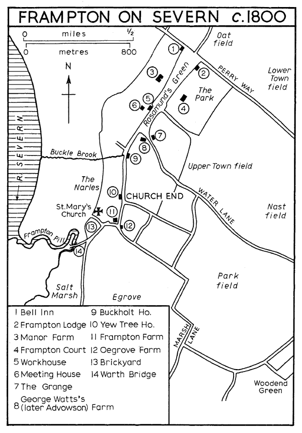
Frampton-on-Severn c. 1800
The village was a relatively large one and in minor ways acted as a centre for an area stretching beyond the parish boundaries. In the Middle Ages Frampton had a market and a fair. (fn. 57) An attempt in the early 14th century by the lord of the manor, Robert FitzPain, to create a borough of Frampton (fn. 58) seems to have come to nothing. No burgess tenure is recorded; (fn. 59) the only possible indications that have been found of a surviving tradition of borough status are a charge, in the early 17th century, of usurping the privileges of a borough (fn. 60) and references between 1683 and 1718 to houses as being in the borough. (fn. 61) The high proportion of non-agricultural occupations in Frampton in more recent times (fn. 62) may result from the attractiveness of the village as a place of residence, not only for the more independent tradesmen but also for gentry and professional people who would draw other tradesmen there to provide for them. Thomas Daniel, licensed in 1643 to practise medicine, (fn. 63) is the earliest known of many physicians and surgeons in Frampton. (fn. 64) The inhabitants in 1798 included an accountant, a surgeon, two cabinet-makers, and a 'carver'. The carver was John Pearce (fn. 65) and funeral monuments by him and by two later Frampton masons, Wilkins and Bennett, are to be seen in the churches of the district. (fn. 66) Four clergymen, of whom the vicar was not one, were living in Frampton in 1842, (fn. 67) and from 1856 the large number of private residents gave employment to such trades as chemist, milliner, music-teacher, piano-tuner, and wine merchant. (fn. 68)
The continuing eligibility of the village has led to the building of several modern houses there and the conversion of cottages and small farm-houses into middle-class houses. The major expansion of the village, however, has been the building by the rural district council of an estate of c. 200 houses north of the green; there were a few small houses there in the late 19th century and a row of council houses was built before the Second World War, but most of the houses were built in the 1960s. Of the outlying settlements most are single farm-houses. Park's Farm, in the south-east corner of the parish, was built in the 17th century, a two-story house with a timber frame largely concealed behind later brick and rendering; it has a rectangular plan, with a central chimney-stack of brick between the front door on one side and on the other a newel staircase to the first floor and attics. Walk Farm, at the north corner of the parish, was perhaps built in the same period, a square-framed building standing on a low stone plinth and cased in brick in the early 19th century. Nastfield (formerly Field) Farm, 1 mile east of the church, was built shortly before 1777 (fn. 69) in brick on a high ashlar plinth, and has a symmetrical entrance front which breaks forward beneath a pediment with a blank bullseye at the centre; the brackets of the modillion cornice and the plat-band are of terra cotta. Townfield Farm, between Nastfield Farm and the village, and two farm-houses in the eastern corner of the parish at Netherhills were built of brick in the late 18th or early 19th century. East of Netherhills is Fromebridge Mill, (fn. 70) with an 18th-century mill-house of rendered brick reputed to have been an inn in the mid 19th century, a pair of cottages of perhaps the same period, and a row of seven two-room cottages built c. 1800. There were also once a farm-house or houses called Woodend and Puddiford's, near Claypits; (fn. 71) the name Puddiford's recalls a family with land in Frampton in the 13th century, (fn. 72) and there was a piece of manorial waste called Woodend Green, with one house beside it, in 1782. (fn. 73) At Oatfield, on the road to Wheatenhurst, there were five houses by 1879, two more had been built by 1920, (fn. 74) and there were altogether 11 in 1968. South-east of the north end of the green are six small houses of the 19th and 20th centuries.
Frampton village is linked with Arlingham, where there was an ancient crossing of the Severn, and with the Gloucester-Bristol road by Perry Way, which follows the line of a Roman road (fn. 75) and was recorded by that name in 1302; (fn. 76) it was a turnpike road from 1726 to 1874, under the same trust as the Gloucester- Bristol road. (fn. 77) That road, marking the south-east boundary, was partly repairable by the parish. (fn. 78) It crossed the Frome by a bridge called Frome Bridge in 1328, (fn. 79) which was to be mended by the lord of the manor and the men of Frampton in 1378. (fn. 80) There were plans for rebuilding the bridge in 1740 (fn. 81) and c. 1867, (fn. 82) by which time it was a county bridge. (fn. 83) Road improvements in the mid 20th century totally altered both Frome Bridge and Wickster's Bridge, by which the road crossed Wickster's brook 2 miles south-west. Wickster's Bridge, recorded c. 1363 as out of repair, (fn. 84) was mended in 1675 (fn. 85) and 1759, (fn. 86) and by 1859 had become a county bridge. (fn. 87) Buckle Bridge and Warth Bridge are mentioned above.
In 1086 27 people in Frampton were enumerated, (fn. 88) and in 1327, though only 12 people were assessed for tax, Frampton had the highest assessment in Whitstone hundred. (fn. 89) Frampton had 85 names, one more than Stonehouse, on the muster-roll of 1542, (fn. 90) and there were said to be 329 adults in 1603. (fn. 91) There may have been a decline in the mid 17th century: whereas 105 families were given in the return of 1650, (fn. 92) in 1672 only 47 houses were assessed for hearth tax, (fn. 93) and the number of adults was said to be 249 in 1676. (fn. 94) From 500 people, living in 100 houses, c. 1710 (fn. 95) the population grew to 600 c. 1775 (fn. 96) and 860 in 1801. It continued to grow until 1831, and then fell from 1,055 to 730 in 1911. Thereafter there was a steady rise to 1,096 in 1961, (fn. 97) but by 1968 further building had taken the total well beyond that figure.
Two unlicensed victualling houses were presented in 1595, (fn. 98) and the 'Boar's Head' was recorded in 1643. (fn. 99) There were two unlicensed alehouses in 1667, (fn. 100) and in 1689 Quarter Sessions ruled that all the alehouses in Frampton be suppressed except the Old Inn and the 'Crown'. Six months later a similar order excepted only the 'Nag's Head' and the 'Golden Heart', but it was also stated that the alehouse near the bridge (presumably Buckle Bridge) ought to be licensed. (fn. 101) There were four victuallers in 1755, (fn. 102) one of whom kept the Bell Inn at the north end of the green, recorded in 1740, (fn. 103) rebuilt in the 19th century, and extant in 1968. Before 1807 there was an alehouse called the 'Old Swan', (fn. 104) and in 1838 there was a public house (the 'Bell') and 7 beershops. (fn. 105) Apart from the 'Bell' there were three public houses in 1939, (fn. 106) of which the 'Three Horseshoes' remained in 1968.
The Frampton Volunteers were raised in 1798 under Nathaniel Winchcombe of Frampton Court, and drew about half their number from nine neighbouring parishes. They were disbanded sometime after 1806. (fn. 107) A friendly society was active from 1816 to 1843 or later, (fn. 108) and in 1842 its club-day was held on Frampton Feast Monday. (fn. 109) Frampton Feast, to judge from the date on which it was held, was a survival from the medieval fair. (fn. 110) A pleasure fair on the green was held at the time of the feast, (fn. 111) and although the feast was discontinued during the Second World War the pleasure fair survived and the feast was revived in 1966. (fn. 112) A Literary and Mechanics' Institute, founded in 1852, (fn. 113) became defunct c. 1890. (fn. 114) Some of its activities were taken on by a Parish Institute, which had a hall built in 1907 by an anonymous benefactor. (fn. 115) The hall remained actively in use in 1968.
In 1643-4 a parliamentary garrison at Frampton served to keep the royalist forces at Berkeley under some control. (fn. 116) In 1662 an unusually severe storm did much damage to the village, destroying a house and 12 barns and uprooting 357 trees. (fn. 117) In 1631 and 1650 opponents of inclosure caused some unrest in the parish, (fn. 118) and in 1766 a riotous mob of 50 began to pull down John Sansum's house. (fn. 119)
The history of Rosamund Clifford (d. c. 1176), (fn. 120) Henry II's 'Fair Rosamund', has been embroidered from the 14th century onwards with much imported legend (fn. 121) and has filled many pages purporting to tell the story of Frampton. (fn. 122) She is authentically linked with the parish only by her father Walter's lordship of the manor and by his grant to Godstow Abbey, where Rosamund was buried, of the mill at Frampton for the good of the souls of his wife Margaret and his daughter Rosamund. (fn. 123) John Clifford (d. 1684) may have fostered the Rosamund story locally: he named one of his daughters Rosamund, (fn. 124) he had his pedigree copied with the original Rosamund included, (fn. 125) and the first recorded use of the name Rosamund's Green (fn. 126) was in the year after he bought his estate in Frampton. (fn. 127) He may have been responsible for the belief that Rosamund was born at Fretherne Lodge, (fn. 128) where his ancestors had lived, but after the demolition of that house (fn. 129) Frampton Court (fn. 130) and, later, the part of Manor Farm called Rosamund's Bower (fn. 131) were regarded as her birthplace.