A History of the County of Gloucester: Volume 11, Bisley and Longtree Hundreds. Originally published by Victoria County History, London, 1976.
This free content was digitised by double rekeying. All rights reserved.
'Stroud: Growth of the town and outlying settlements', in A History of the County of Gloucester: Volume 11, Bisley and Longtree Hundreds, (London, 1976) pp. 104-111. British History Online https://www.british-history.ac.uk/vch/glos/vol11/pp104-111 [accessed 24 April 2024]
GROWTH OF THE TOWN AND OUTLYING SETTLEMENTS.
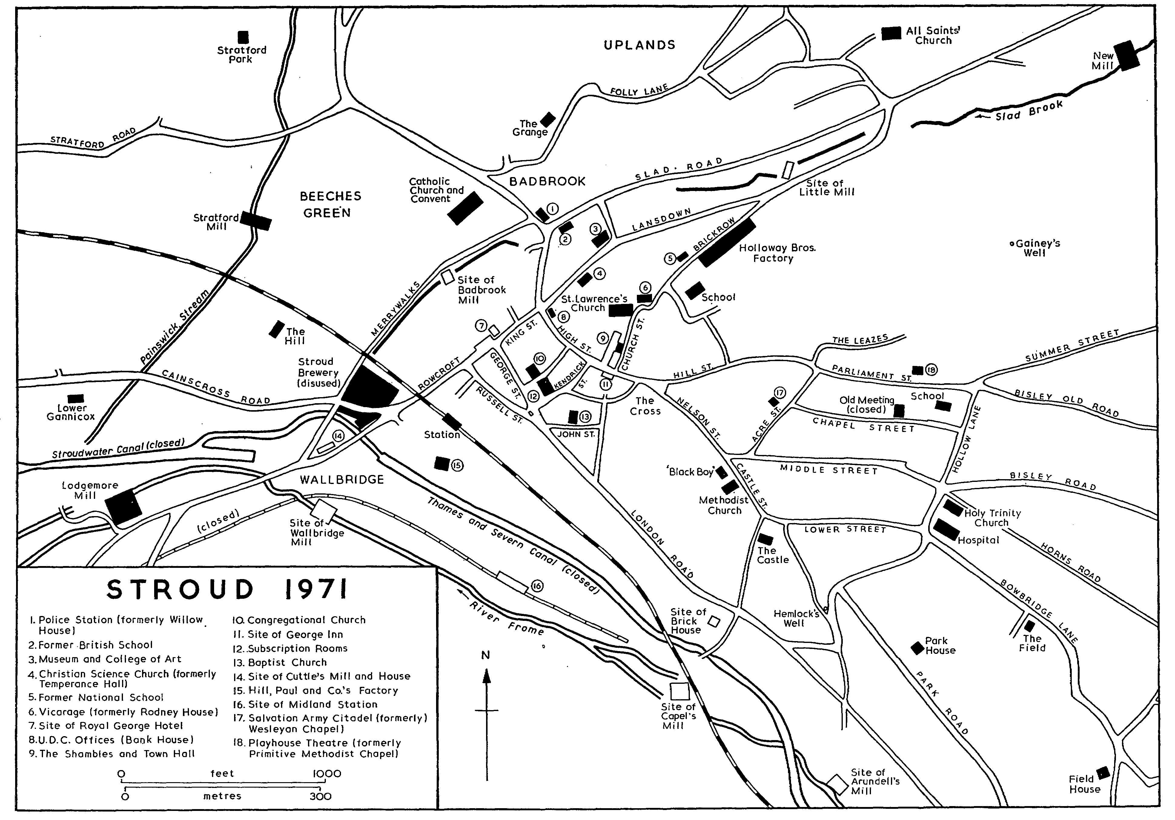
The town of Stroud grew up on the road from Paganhill to Bisley where it climbs the end of the spur above the junction of the Frome and Slad valleys. The church was built north of the road where, known as High Street, it runs steeply up to the place called the Cross; at the Cross the road forked, one branch continuing towards Bisley by way of Hill Street (formerly known in its western end as Tower Hill and its eastern as Silver Street) and Parliament Street, and the other branch leading by way of Nelson Street, Castle Street, and Lower Street to Bowbridge Lane and the old road to Thrupp and Chalford. From its nucleus on High Street the town expanded along the roads above the Cross in the 17th and early 18th centuries and Acre Street, Chapel Street, named from the Congregational chapel built at the beginning of the 18th century, (fn. 1) and Middle Street were established within the fork. At its lower, western end High Street was met by King Street (named from the visit of George III in 1788) (fn. 2) which carried the traffic from the old London turnpike into the town from the south. Within those streets the town was confined until the 19th century, its western extent being roughly marked by the junction of High Street and King Street, and its eastern extent by Hollow Lane and its continuation (later called Trinity Road from the church built there in 1839) (fn. 3) running down from the end of Parliament Street. The life of the town was centred on High Street. The market-place was situated between the street and the church and trading and other activities also took place at the Cross. The chief inn of the town, the George which had opened by 1654, stood on the south side of High Street and in the 18th century 12 other inns stood in or around the street. (fn. 4)
The small market-place north of High Street, known in the 17th century as the Pitching but later usually called the Shambles, (fn. 5) was situated on land called Pridie's Acre which was assigned as the endowment of the church in 1304 and became vested in the body called the Stroud feoffees. (fn. 6) On its east side stands the market-house, built by John Throckmorton, lord of Over Lypiatt manor, c. 1590. (fn. 7) It is a rectangular stone building with a central gable, and above the ground floor, which was the site of shops and stalls, it had originally a large first-floor room and small second- and third-floor rooms. The principal elevation, facing upon the market-place, originally had an arcade of four bays giving access to the ground floor, and the first-floor room was lit by an oriel window. Instability on that front later led to the reduction in size of the two central arches of the arcade and the addition of a buttress, ornamented with classical columns, beneath the oriel window. (fn. 8) The alterations were perhaps part of the repair work which was carried out on the building between 1640 and 1646. (fn. 9) In the late 18th century rooms in the market-house were used by the Red Boys charity school and by a Sunday school (fn. 10) and in the 1780s part was used as a spinning-house by a clothier. In the early 19th century, from which time the building has been called the town hall, the first-floor room was used for meetings of the vestry and the Stroud improvement commissioners and for sittings of the county court and magistrates; from 1856 the Stroud board of health met there. (fn. 11) In 1851 a Gothic extension, designed by Francis Niblett, was built adjoining the north side of the market-house for the county court. (fn. 12) In 1865 extensive restoration of the market-house included the removal of the two upper floors, and the insertion of a new roof for the single high upper room thus created; (fn. 13) it was apparently then that Gothic staircases were built on either side of the front. At a subsequent restoration, before 1890, heavy buttresses were built on either side of the oriel window to support the front. (fn. 14)
In 1726 a blind-house, or temporary lock-up, adjoined the back of the market-house. (fn. 15) At the beginning of the 19th century, however, the blindhouse stood with the stocks at the Cross at the top of High Street. In 1811 it was removed once more to the Shambles, but in 1830 a new blind-house was built in Nelson Street. (fn. 16) A building called the church house, recorded from 1601, evidently also stood in the Shambles. (fn. 17) In the south-east corner of the Shambles above the entry from High Street were two houses belonging to the Stroud feoffees and another three of their houses, including the Butcher's Arms inn, formed part of the west side. (fn. 18) The inn was rebuilt in the early 1830s when a castiron colonnade was put up along the west side, (fn. 19) and a corn exchange, later the church institute, was built in the north-west corner in 1867. (fn. 20)
Few houses of any antiquity survive in High Street and most have modern shop fronts inserted on the ground floor. On the south side a 17th-century house retains a steep gable, and there are two other gabled stone houses in the block above the entrance to Church Street, one having an early-19th-century bow-windowed shop front. Bank House at the bottom of High Street on the north side is an early18th-century building faced in roughcast, with dormers, sash-windows, and a classical porch; the house, with a 19th-century building adjoining it on the east, was once the headquarters of the Gloucestershire Banking Co. but from 1930 it housed the offices of the Stroud U.D.C. (fn. 21) On the north of the Cross a substantial, mid-18th-century stone house, in two occupations, was demolished in 1971. (fn. 22) Some of the other houses in High Street were rebuilt or remodelled with ashlar fronts in the earlier 19th century: typical are the house above the entry into the Shambles, which was rebuilt by the Stroud feoffees in 1846, (fn. 23) and the house below the entrance to Kendrick Street, which was rebuilt by the same body in 1841. (fn. 24) Just off High Street on the east side of Church Street there formerly stood a low gabled stone house, which was assigned as part of the endowment of a charity school by Thomas Webb in 1642; (fn. 25) it was demolished c. 1945. (fn. 26)
Above the Cross the old town was an area of steep and narrow streets of stone houses. In 1971 over 30 17th- or early-18th-century houses survived in that area, most of them in Lower Street, Middle Street, and in Whitehall at the east end of Middle Street; they are of 2 storeys with a central attic gable and usually have a central doorway with 2 stonemullioned windows on each floor. (fn. 27) The area also contains some plain stone cottages of the 18th and early 19th centuries, and there was some later-19thcentury brick development, notably in Middle Street, which replaced Parliament Street and Silver Street as the main thoroughfare when the Bisley road was diverted to it in 1823. (fn. 28) The south side of Middle Street was largely rebuilt with brick terraces in the early 1870s. (fn. 29) Among the older houses destroyed during demolition for redevelopment in the upper part of the old town in the 1960s and early 1970s were a pair of gabled stone houses in Nelson Street, one dated 1676, which was pulled down in 1964, (fn. 30) and a row of 16th- or 17th-century houses in Hill Street, demolished in 1968 and 1969. (fn. 31)
There are very few large houses in the old town; as was noted in the 1770s, the clothiers, generally the wealthiest inhabitants, usually lived at or near their mills. (fn. 32) A group of larger houses was built, however, in the late 18th and early 19th centuries just outside the town at Beeches Green in Painswick parish. (fn. 33) One of the few large houses within the town was Rodney House in Church Street northeast of the church; it became the vicarage in 1912. (fn. 34) The south-west range formed the original house and by the early 18th century had been extended to the east and west to form a rambling gabled house. A stone with the date 1635 and a cloth-mark was reset in a small porch added in the 19th century. (fn. 35) Another large house was the Castle on the south side of Castle Street. There was a house there by 1687 when it was owned by a clothier, Richard Arundell, who died c. 1732. A later owner was the clothier Charles Freebury (d. c. 1795), and in 1809 the Castle was bought by P. H. Fisher, (fn. 36) the historian of Stroud, who occupied it until his death in 1873. (fn. 37) The basement storey retains 17th-century features but the house was extensively remodelled in the 18th century, apparently c. 1789, (fn. 38) and the office wing on the west was enlarged in the 19th century. The house was known as the Castle by 1732, (fn. 39) and the name is evidently older than the embattled folly which is built into the garden wall. Corbett House, west of the Castle, was built between 1820 and 1835. (fn. 40)
Expansion of Stroud in the early 19th century occurred mainly south-west of the old town and was stimulated by the building of the new Bath- Cheltenham road in 1800 and the new London road in 1814. (fn. 41) The former emphasised the importance of King Street and its south-western extension, Rowcroft, and the latter was made to connect with Rowcroft by a street which was later named Russell Street as a compliment to Lord John Russell. (fn. 42) Shortly afterwards another street, known by 1826 as Great George Street (but later called George Street), was made branching out of the new London road at the eastern end of Russell Street to take a more northerly course to King Street. (fn. 43) The development of Russell Street had begun by 1820, (fn. 44) and by 1835 considerable building had taken place in it and Great George Street and in the London road east of their junction. Also by 1835 building had begun on two new streets made to connect High Street with the new London road: Union Street, later renamed Bedford Street, ran from the middle of High Street to Great George Street, and a street, which originally took the name Swan Lane from an ancient lane with which it connected but was later known as Union Street, ran from opposite the Shambles to the new London road. Swan Lane also had a branch running to the London road called John Street, (fn. 45) on which a Baptist chapel built in 1824 was one of the first buildings. (fn. 46) Russell Street, Great George Street, the original Union Street, Swan Lane, and the London road as far as the houses called Frome Buildings at its junction with Swan Lane were all included with the older streets in plans to light the town in 1833. (fn. 47)
The new roads also caused fresh building in the southern end of King Street and in Rowcroft, on which, however, some new houses had been put up in the 1790s, including Rowcroft House on the north-west side, later rebuilt as the premises of Lloyds Bank. During the first decade of the 19th century a terrace of stone houses was put up along the remainder of that side of Rowcroft; in its final form the terrace apparently comprised a symmetrical group, the central and two end buildings accentuated by pediments, but in 1845 the two southern houses were demolished to make way for a railway viaduct. (fn. 48) By 1835 a development of 37 houses called Bath Place had been built between Russell Street and the Thames and Severn canal. (fn. 49)
Stroud 1971
A focus for the new part of the town was provided in 1833 when the Stroud Subscription Rooms were built at the bottom of Bedford Street facing Great George Street over a small square. The rooms, which were built to the designs of George Basevi, (fn. 50) are a rectangular stone building of two storeys, the south front having a central pediment and semicircular headed windows to the ballroom on the first floor; a porch with a balcony above was added in 1868. (fn. 51) A large classical Congregational chapel built on the opposite side of Bedford Street was opened in 1837. (fn. 52)
The opening of the railway with a station south of Russell Street in 1845 further stimulated the development of the south-west part of the town, although it also involved the demolition of some houses, including part of Bath Place. (fn. 53) About 1870 the Imperial hotel, a large three-storey stone building, was built on the north side of the station yard. (fn. 54) Building continued in the existing streets during the middle years of the 19th century, and one new street, Kendrick Street running from High Street to George Street by the east side of the Subscription Rooms, was made in 1871-2; its east side was built up in the upper part with large brick buildings with terracotta dressings, and in the lower part with large three-storey stone buildings, the lowest, called the Cloth Hall, designed for the firm of Libby & Pearce by W. B. Baker of Painswick. (fn. 55)
Expansion north of the town occurred mainly in the later 19th century. There was, however, one earlier development, the Brick Row, a long terrace of houses running north-westwards from the end of Church Street which was built in the early 19th century by Joseph Grazebrook; (fn. 56) the terrace was later demolished to make way for the clothing factory of Holloway Bros. (fn. 57) In 1867 the west side of Badbrook Lane, the extension of High Street down to Badbrook, was built up with new houses by S. S. Dickinson and renamed Gloucester Street; the project involved the demolition of the Chequers inn and a group of old cottages on the corner of King Street. (fn. 58) Shortly before 1872 a plan, which had been mooted as early as 1835, to make a new road from the west end of High Street to meet Slad Road (fn. 59) was realized by a Dr. Paine and the Revd. Edward Mansfield. (fn. 60) By 1882 the new road, which was called Lansdown, was built up at its southern end and the development of its middle section with brick terraced houses was in progress. (fn. 61) Lansdown also became the site of a number of public buildings: near its south end a Gothic group is formed by the public library, built as a private school in 1873, Lansdown Hall, built as a temperance hall in 1879 but later used as a Christian Science church, (fn. 62) and the School of Science and Art, built in the 1890s. (fn. 63) During the later 19th century the town expanded to the north-west, beyond the parish boundary, with the growth of a new suburb called Uplands; it is treated above under Painswick. (fn. 64)
During the 19th century the town expanded most significantly on its east side, beyond Hollow Lane and Trinity Road. In the earlier part of the century Summer Street, running from the end of Parliament Street, Bisley Old Road, and the area in between were gradually built up, mainly with terraces of stone cottages, and at the same period the Leazes, north of Parliament Street, was developed. (fn. 65) The main expansion east of the town occurred after 1873 when the upper part of the Field estate, lying between Bisley Old Road on the north and Bowbridge Lane on the south, was put up for sale in building lots. (fn. 66) The building up of Bisley Road eastwards from Middle Street with large villas in pairs or threes, some modestly decorative with Tudor-style windows, Dutch gables, or bargeboards, had begun by 1882 (fn. 67) and continued during the remainder of the century; concurrently the south side of Bisley Old Road and Belmont Road, running between Bisley Road and Bisley Old Road, were built up with smaller semi-detached brick villas. During the late 1870s and the 1880s a large estate of working-class houses was built by George Holloway on Horns Road, running eastwards from Trinity church; (fn. 68) it comprises a double row of brick terraces north of the road and smaller terraces south of it. Further south William Cowle, the owner of the lower part of the Field estate from 1873, (fn. 69) laid out the Park estate on a new road south of Bowbridge Lane; by 1882 he had built Park House in Italianate style as his own residence and two pairs of Tudor-style stone villas, (fn. 70) and a few other villas of the same type were built soon afterwards. Two terraces of brick houses built between Park Road and the London road before 1882 (fn. 71) were apparently also part of Cowle's development.
The town continued to expand eastwards during the 20th century. In 1921 the Stroud U.D.C. built eight pairs of houses in Bisley Old Road, (fn. 72) and by 1936 two large council estates had been built, one of 72 houses on Summer Street (fn. 73) and the other of over 80 houses in Highfield Road leading off Bowbridge Lane. (fn. 74) The Bisley Old Road council estate was later greatly extended as far as the Bisley road. Considerable private building occurred in the same part of the town in the 1950s and 1960s, notably on the Bisley road and on Bowbridge Lane, and in the London road, where a few detached villas had been built by 1936, (fn. 75) there was also piecemeal development.
During the 1960s and beginning of the 1970s much demolition for redevelopment was carried out in the upper part of the old town, particularly in Parliament Street and in Hill Street, on the north side of which a new police station and magistrate's court were under construction in 1971. In the lower part of Summer Street a large development of bungalows and flats involved the demolition of some of the old cottages. Another development, including a new shopping centre and multi-storey car park, was in progress in 1971 in the lower part of the town between King Street and Merrywalks, a road which runs along the old parish boundary from Badbrook to the Cainscross road. Merrywalks was a road of little importance before the 1960s when a new thoroughfare was built between its southern end and Wallbridge and it became part of a traffic scheme to ease pressure on the route by King Street and Rowcroft.
Outside the town the high ground in the north and east parts of the larger division of the parish was sparsely settled with isolated farmsteads and manorhouses. The ancient manor-houses of Lypiatt Park, Ferris Court, Middle Lypiatt, and Nether Lypiatt stand spaced out along the western edge of the Toadsmoor valley. (fn. 76) A number of farmsteads in the north of the parish, mainly held from Over Lypiatt manor, were recorded from the 16th and 17th centuries. Fennell's Farm, a small 17th-century farm-house with 19th-century extensions, northwest of Lypiatt Park, was held in 1573 by the family of Nichols otherwise called Fennell. (fn. 77) Kilminster Farm, a small farm-house dating in part from the 17th century, was recorded in 1558; it took its name from Thomas Kilmister, the tenant in 1725, having been called successively Baldwins and Churches from previous tenants. (fn. 78) Hill House on the opposite side of the Stroud-Bisley road is basically a 17th-century building which was remodelled in the 19th century, before 1876, when it was given an embattled parapet and Tudor-style windows. (fn. 79) A small cottage north of Kilminster Farm, formerly called Nodlings, was recorded from 1558, (fn. 80) and a house called Little Ferris in 1581 was apparently that known in the early 19th century as Berrymans north-west of Ferris Court. (fn. 81) Two houses called Slatters and Hawkins recorded in 1609 but pulled down by 1725 were apparently near Fennell's Farm. (fn. 82) There were also scattered dwellings in the north part of the Toadsmoor valley, including a house called Deptcombe messuage in 1562, which was later replaced by three cottages, and some cottages in Bismore which were demolished before 1667. (fn. 83)
There were a few ancient farmsteads on Slad Lane in the north-west part of the body of the parish. Stroud House in Steanbridge Slade which the lord of Over Lypiatt granted to Thomas Clissold in 1607 and another Thomas owned in 1721 (fn. 84) may have been at Stroud Slad Farm, a small early-18thcentury farm-house. Higher up Slad Lane a small hamlet called the Vatch includes Abbey Farm and Riflemans, both 17th-century stone houses to which Tudor-style windows were added in the 19th century; the latter was the Rifleman's Arms public house in 1882. (fn. 85) Knapp House, standing above the Vatch, is a late-16th-century stone house with arched heads to the lights of its mullioned windows. Originally it was a small symmetrical building, but near-contemporary extensions were made on the north and on the south-east. At the bottom of Slad Lane, Slade House is a three-storey double-pile house of c. 1710 which may have replaced the adjoining 17th-century building, used as outbuildings in 1971.
The southern part of the eastern division of the parish was more thickly populated, with a succession of cloth-mills at intervals of 300-400 yards along the Frome, and, higher up, loosely grouped settlements of cottages and some large clothiers' houses lying on or around the old road from Stroud town to Chalford. Nearest to the town, and later encompassed by its suburbs, there was a straggling settlement on Bowbridge Lane by the late 17th century. The two large houses there, the Field and Field House, are described below. On the south-west side of the lane a pair of stone-built cottages, formerly a single house, dates from at least the 16th century; cusped lights from a medieval window have been reset in a north-west wall, and an adjoining building, demolished in 1960, contained a cruck truss. (fn. 86) Further up the lane on the same side a long stone range includes at its south-east end a small 17thcentury house called Daneway, which has central gables on both main elevations. About 1690 there were four cottages on the opposite side of Bowbridge Lane around Crease Gate, where the lane was joined by the track from Nether Lypiatt, (fn. 87) but only one small stone cottage, and that of a later date, survived there in 1971. In the 18th and early 19th centuries several houses were built at the bottom of the lane at the complex of mills and dye-works at Bowbridge, but most were demolished in 1961 and 1962. (fn. 88) Near by where the old road turned up the hill again to Thrupp another small group includes the Gunhouse, a substantial early-17th-century house which was occupied by a clothier, John Webb, in 1659. (fn. 89)
East of Bowbridge Lane, where the Lime brook and a tributary run down wooded coombs from the high ground of the central spur, there were scattered cottages by the late 17th century. Together with the cottages on Bowbridge Lane, they belonged to the Clutterbucks' Thrupp estate (fn. 90) and in the earlier 18th century were usually leased to families of weavers. (fn. 91) A group called Weyhouse Cottages, standing by the track from Nether Lypiatt to Crease Gate, (fn. 92) fell into disuse in the 20th century in the absence of an access road and was in ruins in 1971. The occupation of another group of cottages to the south-east was preserved by the making of a tarmac surface to the track leading up from Thrupp c. 1950. (fn. 93) They include a 17th-century cottage, which was the Foresters' Arms public house in 1842 and until c. 1965, (fn. 94) and a row of three cottages which was converted to become the farm-house of Claypits farm. The little group of cottages at the Heavens near by was in existence by 1775 (fn. 95) but was rebuilt in the late 19th century. Further north a row of three 17th-century cottages, known as Rifle Butts from the use made in the late 19th century of the Horns valley below, (fn. 96) was converted to a single dwelling in the mid 20th century.
Thrupp, more usually called the Thrupp, was recorded as a settlement name from 1367 (fn. 97) and seems to have originally applied to the group of houses at a bend in the old road, where Thrupp House, the centre of the Clutterbucks' estate, (fn. 98) an adjoining cottage which was later the farm-house of the estate, and a few other cottages stood by the late 17th century. (fn. 99) A few more cottages were added in the 18th or early 19th century. A larger settlement, however, was further along the road at the hamlet which was also named as Thrupp in 1820 (fn. 100) but was later distinguished as Far Thrupp. A few 17th- or early-18th-century houses survive there including the former farm-house of Yew Tree farm. A larger number of cottages was added in the later 18th century, and the building of the new London road in 1814 caused the hamlet to expand westwards down the hill so that it became the largest and most compact settlement in the eastern division of the parish outside Stroud town. Further down the old road Upper Bourne and Lower Bourne also had small settlements of cottages by the early 19th century, (fn. 101) and presumably much earlier, for Bourne was described as a vill in 1304. (fn. 102) At Quarhouse on the lane up to Nether Lypiatt the establishment of another small hamlet had begun by 1687. (fn. 103)
Along the bottom of the valley, the growth of small settlements around the mills and crossingpoints of the river was stimulated by the building of the canal in 1789 and the new London road in 1814, and a number of inns opened to serve users of road and canal. At Wallbridge by 1820 there was the Ship and by 1856 also the Bell. Bowbridge had the New Inn by 1856, and the Ship at Brimscombe Port had opened by 1820. At Bourne in 1820 there was the Quay inn and in 1856 the Railway, the Railway Canal, and the King's Arms. (fn. 104) In the later 19th century the London road began to be developed, particularly at Far Thrupp and Brimscombe where brick terraces were put up. The earlier 20th century saw further building all over the valley: a new settlement was created at Blackness at the bottom of the Toadsmoor valley, and in the 1920s and 1930s there was ribbon development, with detached and semi-detached houses, along the old road south of Thrupp and at Bourne. In the mid 20th century new factory buildings put up for some of the industries which settled on the old mill-sites along the river emphasised the long-standing industrial nature of the valley.
There were several large houses, mostly owned by clothiers, scattered along the valley. On Bowbridge Lane were two substantial houses, the one nearest the town called the Field and another further down the lane called Field House. The Field belonged to the Arundell's Mill estate and descended to the Revd. John Hawkins (d. 1871), whose trustees sold the house in 1873 to William Cowle (fn. 105) (d. 1899). (fn. 106) It is basically a 17th-century house, to which a new ashlar west front in classical style was added in the 18th century; ground-floor bay-windows were inserted on the front in the 19th. Field House incorporates on the north-east a 17th-century range with a central oak staircase around a well, some original windows, and two surviving gables with oval lights. Early in the 19th century a range was added on the south-west to provide a new entrance hall and living-rooms and the end walls of the older block were rebuilt to match the new work. The new part may have replaced an older wing, for in 1825 when it belonged to Samuel Clutterbuck of St. Mary's Mill the house was said to have been recently taken down and rebuilt. (fn. 107) In 1971 it was the headquarters of the Gloucestershire wing of the Air Training Corps. At the bottom of Bowbridge Lane, on a site which after 1814 was bounded on the east by the London road, stands another remodelled 17th-century house, which with an adjoining dyeworks belonged to Nathaniel Partridge in 1842. (fn. 108) The back is of rubble with some stone-mullioned windows, but c. 1800 the house was given an ashlar south-west front in classical style.
Bowbridge House on the east corner of Bowbridge Lane and the London road is a large three-storey stone house with a classical porch and a venetian window above. It was probably the house Thomas Newcombe, the owner of a near-by mill, was building in 1804, (fn. 109) for it belonged to a subsequent owner of the mill, Richard Sandys, in 1842. (fn. 110) The house called the Thrupp on the south side of Thrupp Lane was evidently that which belonged to the Griffin's Mill estate in 1740 and until 1794 when it was sold to John Partridge of Bowbridge. In 1807 John's son Thomas sold the house to William Stanton of Stafford's Mill who occupied it until his death in 1841. (fn. 111) Stanton evidently rebuilt the Thrupp, which is a three-storey stone house. (fn. 112) New House at Far Thrupp, later renamed Brimscombe Court, belonged in 1769 to the Wathens, (fn. 113) owners of Thrupp Mill; the family occupied it until c. 1830 (fn. 114) and in 1845 their trustees sold it to Nathaniel Marling. (fn. 115) It was evidently rebuilt c. 1800 and is a three-storey stone house with shaped parapets at the sides and a classical porch. In 1971 it was occupied as several flats.
In Paganhill tithing, the detached western portion of the parish, the earliest settlement was evidently at the village which gave the tithing its name, of which Pakenhill was an alternative form used into the 20th century. (fn. 116) The village had a chapel of ease by 1287, (fn. 117) and the manor-house of one of the ancient divisions of Paganhill manor was at Field Place at the west end of the village. (fn. 118) Several 17th- and early 18th-century cottages survive in the village, including a row near Field Place of which the northernmost is dated 1714 and the southernmost has housed the Old Crown inn since at least 1879. (fn. 119) The other cottages are mainly of the later 18th century and include a three-storey row of five at the road junction in the centre of the village. Upfield, one of the larger residences, which in 1971 housed a boys' preparatory school, is a Tudor-style stone building of the early 19th century. The Rose inn on the east side of Paganhill Lane south of the village had opened by 1822, (fn. 120) and in the mid 19th century there was also the Stag and Hounds opposite. (fn. 121) Farmhill House, on the east side of the road running up to Whiteshill, was the manorhouse of one part of Paganhill manor, and there was formerly another large house, called Farmhill Park, on the opposite side of the road. (fn. 122)
By the early 19th century the most populous area of Paganhill tithing was at the twin villages of Ruscombe and Whiteshill in its high northern part. The two villages run together at the head of the deep coomb formed by the Ruscombe brook, Whiteshill lying along the eastern edge and Ruscombe forming a smaller and more straggling settlement along the western edge. (fn. 123) A settlement had been established at Ruscombe by the mid 14th century, (fn. 124) and the largest house in the village, Ruscombe Farm, was recorded from 1532; (fn. 125) Whiteshill has not been found as a settlement name before 1732. (fn. 126) Both villages have a few 17th- or early-18th-century cottages, including the one at Whiteshill which has been the Star inn since at least 1782, (fn. 127) and Rake End at Ruscombe which is dated 1713. The majority of the houses, however, are plain stone cottages built during the later 18th and early 19th centuries with no distinctive features. A few brick or stone cottages were added in the late 19th and early 20th centuries, including a group of small modestly decorative stone villas built at the south end of Whiteshill c. 1900. (fn. 128) At the beginning of the 19th century the two villages had the reputation of being the most poverty-stricken and morally-degraded part of Stroud parish, a condition which the building of an Independent chapel at Ruscombe and a church at Whiteshill was later thought to have much alleviated. (fn. 129)
There are a few smaller groups of houses in the north part of the tithing. The Plain on the PaganhillWhiteshill road, where the pound for the tithing was sited in 1825, (fn. 130) has a few 18th-century stone cottages. At Callowell east of the road Callowell Farm is a gabled and mullioned 17th-century farmhouse. It was evidently the Callowell House that Giles Gardner of Stratford acquired in 1684, (fn. 131) although at the same period there was another Callowell House standing near by, which Thomas Wood, a clothier, bought in 1683. (fn. 132) A 17th-century cottage which stood just north of Callowell Farm and housed the Plough inn from at least 1882 (fn. 133) was pulled down c. 1966, (fn. 134) and there are also a few later stone cottages. The hamlet was called Upper Callowell in 1782 in distinction to a house called Lower Callowell which stood some way to the southeast (fn. 135) until it was demolished shortly before 1891. (fn. 136) Stokenhill Farm further north is a late-17th-century farm-house of two storeys and gabled attics. The narrow central entrance bay is flanked by cross-wings with symmetrical fenestration. (fn. 137) A central porch which was subsequently added to the principal front on the south has a sundial dated 1717. The house belonged to William Gardner of a prominent local family in 1741. (fn. 138) Kite's Nest Farm north-east of Whiteshill village is a small 18th-century stone farm-house.
There was very little development in the extreme south of the tithing before the building of the new Stroud-Cainscross road in 1825. (fn. 139) One of the few houses there earlier was Gannicox, later called Lower Gannicox to distinguish it from a house built north of it called Upper Gannicox. Lower Gannicox belonged in the early 18th century to Thomas Bond, and passed in succession to his brother Henry Bond (d. 1757), curate of Stroud, and his nephew, William Knight, a London banker (d. 1786). (fn. 140) In 1971 it was a nursing home. The house is a three-storey building which appears to be largely of the later 18th century. The long brick south front was symmetrically arranged (although the doorway was later moved to one side) and has a central pediment and canted bay-windows at each end. North-west of the house the brick stable block, now partly demolished, evidently also had a symmetrical elevation. Upper Gannicox was built in the early 19th century, and is a three-storey house with an ironwork verandah on the ground floor. The buildings called Prospect Place, which stand on the north side of the Cainscross road but pre-date it by a few years, (fn. 141) comprise a terrace of four plain stone houses, with a more elaborate house on the west end and two brick houses added on the east end in the later 19th century. The houses at Stratford Park and Stratford Abbey in the east part of the tithing are mentioned below. (fn. 142) Stratford Cottage, opposite the entrance to the drive of Stratford Park, is a Gothicstyle stone house built shortly before 1804. (fn. 143)
Considerable building occurred in Paganhill tithing during the 20th century. The development of Stratford Road leading eastwards from Paganhill village began c. 1900 when some brick villas were put up on the south side; the Stroud U.D.C. began building council houses on the south side of the road in 1925, and by 1929 it had built 14 pairs along the north side. (fn. 144) By 1936 another council estate had been built on the north of Paganhill village and the development of the former grounds of Farmhill Park further up the Whiteshill road had begun. (fn. 145) In the 1950s and 1960s much building took place on the east side of the Whiteshill road so that by 1971 there was a continuous belt of housing up that side as far as the Plain. A private estate was built in the 1960s south-west of Paganhill village. On Cainscross Road a row of brick houses was put up west of Upper Gannicox in 1899 or shortly afterwards (fn. 146) and similar houses were built on the east side of Beard's Lane near by. Some detached villas had been built on the south of Cainscross Road by 1936 (fn. 147) and by 1971 there had been a further development east of Upper Gannicox. In the north of the parish a council estate was added south-east of Whiteshill village, and during the 1950s and 1960s many houses and bungalows were built north of it, while in Ruscombe village several new houses were put up among the older cottages.