A History of the County of Gloucester: Volume 4, the City of Gloucester. Originally published by Victoria County History, London, 1988.
This free content was digitised by double rekeying. All rights reserved.
'Gloucester: The castle', in A History of the County of Gloucester: Volume 4, the City of Gloucester, ed. N M Herbert (London, 1988), British History Online https://www.british-history.ac.uk/vch/glos/vol4/pp245-247 [accessed 30 April 2025].
'Gloucester: The castle', in A History of the County of Gloucester: Volume 4, the City of Gloucester. Edited by N M Herbert (London, 1988), British History Online, accessed April 30, 2025, https://www.british-history.ac.uk/vch/glos/vol4/pp245-247.
"Gloucester: The castle". A History of the County of Gloucester: Volume 4, the City of Gloucester. Ed. N M Herbert (London, 1988), British History Online. Web. 30 April 2025. https://www.british-history.ac.uk/vch/glos/vol4/pp245-247.
GLOUCESTER CASTLE
A castle (fn. 1) was built at Gloucester soon after the Norman Conquest, 16 houses having been demolished to make way for it. (fn. 2) It was placed in the custody of the sheriff of the county, Roger of Gloucester. That castle, distinguished as the old castle in 1143, (fn. 3) probably had as its motte the mound called Barbican hill, in the south-west part of the town at the south end of the later Barbican Road. Archaeological evidence, however, has led to the suggestion that the first structure was a ditched enclosure within the south-west corner of the old Roman town and that the Barbican hill motte was a later addition near the end of the 11th century. (fn. 4)
Before 1112 Walter of Gloucester built a new castle west of Barbican hill on a former garden of Gloucester Abbey, overlooking the Severn. (fn. 5) The hereditary sheriffs held Gloucester castle until 1155. Later it was retained by the Crown, passing with the borough lordship to the widows of Henry III and Edward I. Henry III often used it as a residence, and it played an important role in the barons' war of the 1260s. (fn. 6) Under the Crown the castle was the responsibility of the county sheriffs (fn. 7) and of constables appointed during pleasure or for life. (fn. 8) The perquisites of the constableship included Castle Meads, on the opposite bank of the river from the castle, (fn. 9) and a custom called the tyne of ale (later castle cowle) which was levied on the brewers of the town until the mid 16th century. (fn. 10) Part of the castle was being used as a gaol by 1185 and it was probably then the official county gaol, as it certainly was by 1228. (fn. 11)
A chapel in the castle and the offerings made there belonged to St. Owen's church, presumably by gift of Walter of Gloucester, and in 1137 were included in the endowment of Llanthony Priory. (fn. 12) The priory later exercised full parochial rights in the castle; (fn. 13) a claim by Gloucester Abbey to those rights was apparently not pursued after 1197. (fn. 14) The castle and its defences, together with Barbican hill which was probably maintained as an outwork, were excluded from the borough boundary in a peninsula of the county. In the postmedieval period the site formed part of the extraparochial North Hamlet. (fn. 15)
In the mid 13th century, when it had reached its fullest extent and strength, the castle and its defences covered c. 8 a. of the south-western sector of the town. (fn. 16) It was defended on the west by the Severn and on the other sides by moats, for most of the circuit a double line. There were three entrances. The main entrance on the north-east, leading to the town by way of Castle Lane, had inner and outer gatehouses and drawbridges over the moats. On the west a gateway opened on a bridge across the Severn, defended at its western end by a brattice; the bridge was rebuilt in 1222, and again in 1265 after its destruction in the siege of the previous year. On the south another gateway and drawbridge led to a road to Llanthony Priory. The curtain wall within the moats included towers and turrets with a tall tower over the inner gatehouse on the north-east. Within the wall were several baileys, one of which was attached to the office of county sheriff in 1222, and a vineyard and herb garden. The central feature was a massive square keep, evidently built by Walter of Gloucester in the early 12th century; it was heightened in the 1230s. A chapel adjoined the keep and was probably contemporary with it. The other buildings, most of them built in the 1240s and 1250s for Henry III and his family, included the king's and the queen's chambers, each with chapels, a great hall, and a kitchen. All of those buildings were apparently ranged round the curtain wall.
Although few additions were made to the castle after the 1260s, the defences were kept in full repair until the mid 15th century. (fn. 17) According to later tradition it was in Richard III's reign that the castle ceased to be maintained as a fortress, continuing in use later only as the county gaol. (fn. 18) The office of gaoler had become attached to the constableship by the late 14th century, (fn. 19) and in the post-medieval period the constable, who held for life by letters patent and had custody of all of the castle buildings, usually sublet his rights to deputies, who acted as, or appointed, gaolers. In spite of early 16th-century statutes covering castles used as county gaols, the rights of the county sheriff in Gloucester castle remained vague and undefined, and in the late 17th century the constable claimed that the sheriff might house prisoners there only by agreement with him. In 1672, following a lawsuit, the sheriff established his right to use the inner yards and surviving buildings for the gaol, (fn. 20) and the constable, though his patents still included the whole site, was later required to grant leases of those parts to the county. From 1712 to 1810 the constableship was held by the Hyett family, tenants of Marybone House which adjoined the castle grounds on the north-east side. (fn. 21)
Parts of the castle buildings were demolished in 1489 and the stone used for road repairs. (fn. 22) In 1529 the city corporation was allowed to take stone from the castle for building the new Boothall, on condition that it left enough for repairs to the gaol, (fn. 23) and in the 1590s the corporation used much stone from the site for road repairs. (fn. 24) By the mid 17th century all the buildings around the curtain wall had apparently gone, leaving only the keep, used as the gaol, and the main gatehouse standing. Most of the wall itself was removed in the 1630s and 1640s, the stone being sold by the deputy constable for roadworks or burnt in a limekiln at the site. New low walls were built to enclose the gaol area, and c. 1650 the county authorities, who had temporarily asserted their rights against the constable, built a brick bridewell on the north side of the keep. (fn. 25) Thomas Baskerville, who visited the castle in 1683, said that the gaol was 'esteemed… the best in England, so that if I were forced to go to prison and make my choice I would come hither'; the prisoners' ample scope for fresh air and exercise was mentioned in 1714. The precincts included a flower garden kept by the gaoler's wife and a bowling green, used by inhabitants of the city (fn. 26) as well as by the gaoler and his prisoners. (fn. 27) The attractions of the area were enhanced in the 1740s when the constable Benjamin Hyett laid out an ornamental garden on the castle grounds to the east and south of the gaol. (fn. 28)
John Howard reported unfavourably on the county gaol in 1777, and from 1783 a leading county magistrate Sir George Onesiphorus Paul promoted its reform and rebuilding on lines advocated by Howard, including the provision of separate cells. An Act of 1785 empowered the county magistrates to build a new gaol, and they acquired for that purpose the central part of the castle site, buying out the Hyetts' interest. (fn. 29) Demolition of the castle keep began in 1787, (fn. 30) and the new gaol, designed by William Blackburn and completed under the supervision of John Wheeler, (fn. 31) was finished in 1791. The extensive, three-storeyed buildings were ranged around three quadrangles and housed a gaol, penitentiary, and house of correction; in the perimeter wall on the east side was a gatehouse. (fn. 32) In 1826, to the designs of John Collingwood, the perimeter walls were extended eastward to Barbican Road, a new debtors' prison was built east of the gatehouse of 1791, and a new gatehouse was built in the north-east part of the wall, opening on the Castle Lane approach. (fn. 33) In the years 1844–50 a new convict prison, originally organized on the 'Pentonville' separate system, was built east of the gaol of 1791. It incorporated the original gatehouse, to which large three-storey cell-blocks were added on the north and south, and on the west, linking it to the old prison, a block containing a chapel. A treadmill was built south of the old prison. (fn. 34) Among buildings added later in the mid 19th century was a governor's house built in the south perimeter wall facing Commercial Road. (fn. 35)
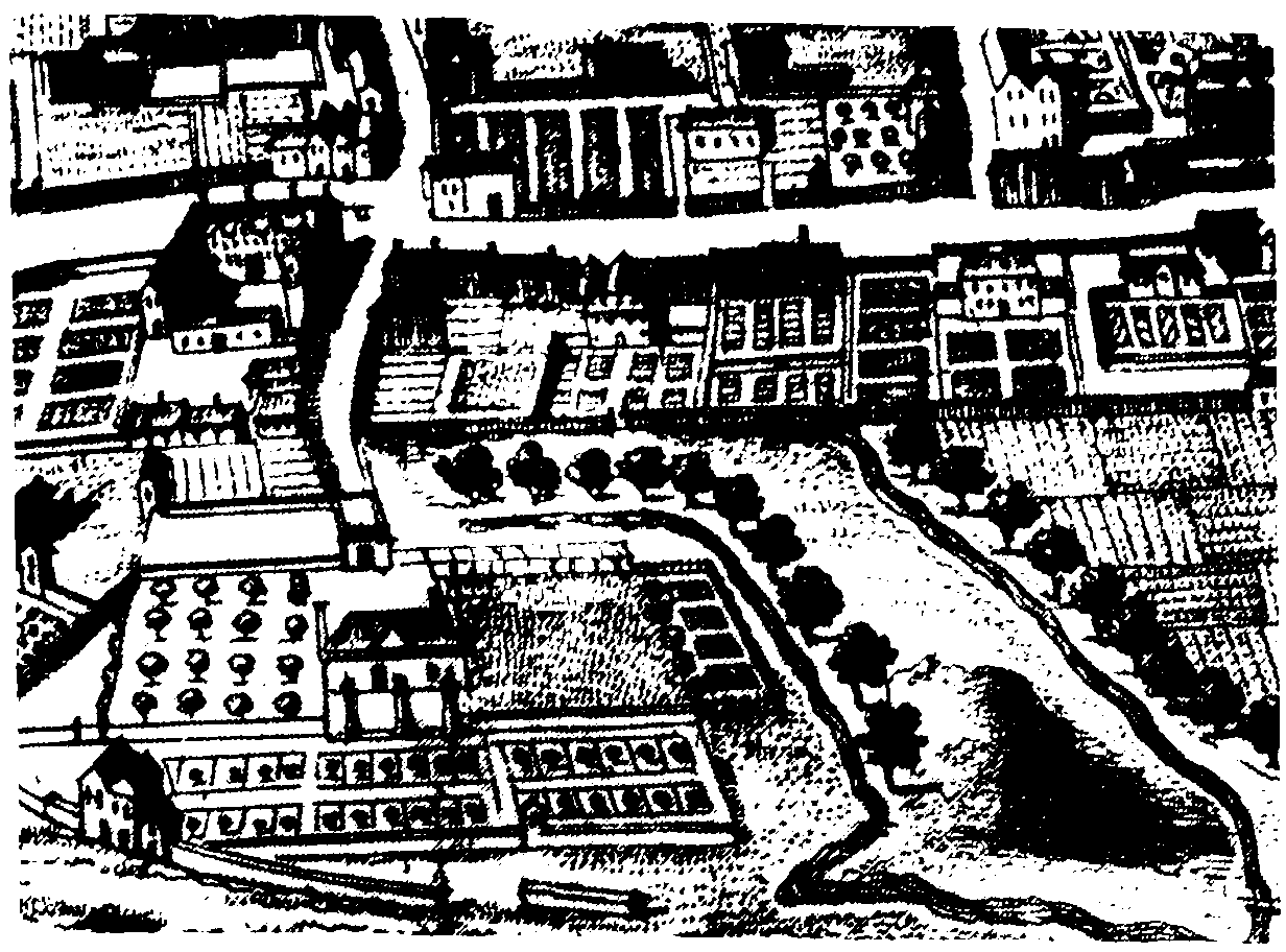
Gloucester castle, c. 1710, with Castle Lane leading to Bearland on the north (top) and Barbican hill on the east
In 1878, under the Prisons Act of the previous year, the buildings passed from the control of the county magistrates to become H.M. Prison, Gloucester. (fn. 36) The eastern ranges of the prison of 1791 were demolished in the late 19th century or the very early 20th, but its western range remained in use for female prisoners until c. 1915 when the prison became an all-male establishment. The western range was demolished c. 1920, (fn. 37) and in 1921 a terrace of eight houses for prison officers was being built at the north-west corner of the site, facing the road along the riverside and excluded from the secure area by an alteration in the perimeter wall. (fn. 38) In the years 1985–6 those houses and other buildings on the west part of the site were cleared and a new reception and administration block was built overlooking the road along the riverside. In 1986 the prison of the 1840s, relatively little altered since it was built, housed prisoners from the area covered by the Crown courts of Gloucester, Worcester, and Hereford, while a small new block east of it housed a unit for 'special category' prisoners, opened in 1971. (fn. 39) Of the earlier buildings the gatehouse of 1826 and the former debtors' prison, from which the top storey had been removed, still survived.
In 1816 commissioners for Crown lands sold some of the old castle grounds outside the walls of the county prison to John Phillpotts, tenant of Marybone House under the Hyetts, and Phillpotts apparently also had a grant of the constableship. Those lands included Barbican hill, (fn. 40) which was levelled c. 1819 (fn. 41) and built over in the mid 1830s, (fn. 42) and a garden behind Marybone House, which was sold with the house when it became the police station in 1858 (fn. 43) and was covered by the new police station and sessions courts in the 1960s. Castle Gardens, another part of the castle grounds lying north of the prison, (fn. 44) was used in the mid 1850s as the site for the militia barracks (fn. 45) and in the 1970s for a new wing of the Shire Hall. All the former castle grounds, except those occupied by the prison, were placed within the city boundary in 1874, (fn. 46) and the prison was included in the city in 1896. (fn. 47)