A History of the County of Gloucester: Volume 9, Bradley Hundred. The Northleach Area of the Cotswolds. Originally published by Victoria County History, London, 2001.
This free content was digitised by double rekeying. All rights reserved.
'Parishes: Sevenhampton', in A History of the County of Gloucester: Volume 9, Bradley Hundred. The Northleach Area of the Cotswolds, (London, 2001) pp. 166-187. British History Online https://www.british-history.ac.uk/vch/glos/vol9/pp166-187 [accessed 24 April 2024]
In this section
SEVENHAMPTON
Sevenhampton is a rural parish high on the Cotswolds 9 km. east of Cheltenham. The ancient parish contained 3,377 a. (fn. 1) (1,367 ha.) mostly in a long and relatively thin band of land extending eastwards from the edge of the Cotswold escarpment to Hampen, in the southeast. On the west the parish boundary on the scarp above Prestbury and Charlton Kings was in 1732 a way to Winchcombe (fn. 2) and on the east, where Sevenhampton had a peninsulated part extending northwards, the boundary followed ancient routes including, in the northern part, a salt way recorded in the 10th century. (fn. 3) The river Coln, rising at springs in Sevenhampton and Charlton Abbots, to the north, (fn. 4) bisects the parish from north to south, and streams flowing from some of its sources marked short sections of Sevenhampton's long northern boundary. The other boundaries were field boundaries. In 1935 the northern tongue of land was included in the new civil parish of Sudeley, leaving Sevenhampton with 2,843 a. (fn. 5) (1,151 ha.), and in 1987 land at Hampen was transferred from Shipton to Sevenhampton, making part of the boundary between the two parishes a disused railway line (fn. 6) and increasing Sevenhampton's area to 1,162 ha. (fn. 7) This account deals with Sevenhampton as it was constituted before 1935.
The river Coln, which in 1531 was called Senhampton brook, (fn. 8) has cut a narrow valley through the centre of the parish at c. 180 m. Short valleys run at right-angles into the central valley and at the western end of the parish the upper part of a tributary stream runs southwards in a deep valley at Puckham. The south-eastern part of the parish includes the upper part of a wider tributary valley, known as Hampen bottom, running south-westwards. Above the valleys the land rises steeply to over 280 m. and in the far west it reaches 310 m. near the highest point of the Cotswold escarpment. In the northern peninsulated part of the parish, comprising White hill and, to the north, Bespidge hill, the land falls away steeply to the north-west. Near the summit of Bespidge hill, known as Grim's hill in the 10th century, (fn. 9) Roel Camp is a prehistoric earthwork, probably an Iron-Age hillfort. (fn. 10) While the soil of the Coln valley is formed by the Upper Lias clay and the Midford Sand, most of the higher land of the parish is on the Inferior Oolite. Some high ground is formed by overlying strata of fuller's earth and the Great Oolite and an area in the west towards Puckham by a large outcrop, defined by faults, of the Cotswold slate or tile beds at the base of the Great Oolite. (fn. 11) The parish has been much quarried and the numerous abandoned quarries include extensive slate workings in the west.
Settlement in the parish is scattered, with several clusters of cottages in the Coln valley and a number of isolated farmsteads on the higher downs. The parish name, first recorded in 1086 and with later variants including Senhampton and Sennington, indicates seven settlements. (fn. 12) Some of the isolated farmsteads cover Roman sites and there were several small hamlets or farmsteads in the west of the parish in the early Middle Ages. (fn. 13) The village of Brockhampton on the north side of the parish above the Coln had probably become the principal or largest settlement in the parish by 1327 when parishioners were assessed for the subsidy under the heading of Brockhampton with Sevenhampton. (fn. 14) With its own open fields and commons in the northern part of the parish, (fn. 15) Brockhampton was sometimes accounted a separate manor by the later 16th century (fn. 16) and it had clearly defined boundaries including, on the west, the river Coln. (fn. 17)
Sevenhampton formed part of the bishop of Hereford's estate at Prestbury in 1066 and remained part of the estates of that see until the mid 16th century. In the later Middle Ages the parish included a number of open fields and commons and, in the west, extensive woodland centred on the valley at Puckham. The northern part of the parish, which had been included in the boundaries of a wood described in the 10th century, (fn. 18) retained several wooded areas in the 17th century (fn. 19) but Bespidge wood, comprising 32 a. on the northern boundary, was the only woodland there in the early 19th century. (fn. 20) Puckham woods (or wood), which were partly in Prestbury parish, were presumably represented in 1086 by woodland recorded on the bishop of Hereford's Prestbury estate. (fn. 21) The bishop had established a warren in the woods by the 1270s (fn. 22) and the episcopal estate derived an income from sales of wood and undergrowth in the later Middle Ages. (fn. 23) Under a lease of 1565 the large timber trees were reserved and only two fellings were permitted during the 21-year term. (fn. 24) In 1575 the woods contained 214 a. divided into 13 'sales' or coppices, including Annis wood (fn. 25) which was among woodland in several ownership in the late 14th century. (fn. 26) Puckham woods were intercommoned by the tenants of Sevenhampton and Prestbury manors until the mid 17th century when, under an agreement of 1657 giving the woods' area as c. 320 a., the warren was destroyed, c. 40 a. on the east side of the valley was allotted to the lord of Sevenhampton and c. 100 a. on the west side, mostly in Sevenhampton, to the lady of Prestbury. The rest of the woods were divided into separate commons for Sevenhampton and Prestbury respectively, the division evidently following the parish boundary. Under the agreement the lady of Prestbury had liberty to dispose of the coneys in that part of the woods belonging to her manor; (fn. 27) the land assigned to her became farmland known as Puckham warren. (fn. 28) A wood called Prior's grove was retained in hand by Llanthony priory in 1418. (fn. 29) By agreement in 1563 it was to be divided between the two owners of the former priory estate and felled (fn. 30) but in the later 17th century the eastern part of Puckham woods included an area called Prior's coppice. (fn. 31)
Inclosure of the open fields and commons was a piecemeal process completed in 1818 by parliamentary inclosure. (fn. 32) The area of woodland in Sevenhampton, which was increased in the 19th and 20th centuries, was 226 a. in 1905. (fn. 33) Many of the new plantations created before the First World War were in the northern part of the parish (fn. 34) and the later plantations included a belt of woodland along the parish boundary west of Puckham. (fn. 35) In the mid 1720s Sir William Dodwell began walling in c. 80 a. west of the Syreford—Winchcombe road for a park in front of his house (later Brockhampton Park). The park, the creation of which was completed after Dodwell's death in 1727, (fn. 36) contained an avenue of trees aligned on the house. (fn. 37) A herd of deer established in the park by the 1870s (fn. 38) dispersed during the Second World War and the few remaining deer were removed in the early 1950s. (fn. 39) In the late 1990s an equestrian centre was built in the park. (fn. 40)
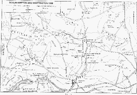
Fig. 13: Sevenhampton and Whittington, 1998
According to the Domesday survey of 1086 there were 24 tenants in Sevenhampton. (fn. 41) Parts of the parish were depopulated in the early 14th century (fn. 42) and 21 persons in Brockhampton and Sevenhampton were assessed for a subsidy in 1327. (fn. 43) There were said to be 20 households in the parish in 1563 (fn. 44) and the number of communicants was estimated at 140 in 1551 (fn. 45) and 125 in 1603. (fn. 46) A hearth-tax return for 1672 named 24 householders in Sevenhampton and Brockhampton. (fn. 47) The parish's population, which c. 1710 was reckoned at 180, (fn. 48) increased in the 18th century (fn. 49) and was 349 in 1801. After falling slightly in the first decade of the 19th century, it resumed its rise and in 1851 it stood at 553. In the later 19th century the population declined and in 1901 it was 400. The boundary change of 1935 was only partly responsible for a further decline from 422 in 1921 to 308 in 1971. Thereafter the population rose to 376 in 1991. (fn. 50)
In the later Middle Ages roads and paths crossing or touching the parish were used by travellers to and from Winchcombe and the pilgrimage centre of Hailes to the north. In 1531 a route in or near the centre of the parish was known as Hailes way (fn. 51) and in 1611 a man was presented in the manor court for having ploughed up an old footpath to Hailes. The market way recorded in 1626 (fn. 52) probably followed the route of the road from Syreford, in Whittington, to Winchcombe, which ran northwards through the centre of the parish and was known in 1638 and later as the port way. (fn. 53) In the mid 19th century the road linked Winchcombe with the Cheltenham–London road at Andoversford. (fn. 54) It remained the most important south-north route through the parish in the late 20th century.
A lane running south of Puckham woods was part of a highway from Stow-on-the-Wold in 1387 or 1388 (fn. 55) and was known as the white way in 1652. (fn. 56) In the mid 18th century it was part of a route to Cheltenham which, in the east of the parish, ran down through Brockhampton from a road junction on the boundary with Hawling. (fn. 57) In the mid 1720s Sir William Dodwell diverted the section of the lane between Brockhampton village and the port way southwards away from his house (fn. 58) and probably moved the section west of the port way similarly to create the park mentioned above. In the west of the parish the lane once took a shorter route from east to west (fn. 59) but by the early 19th century its course followed a road from Syreford running north-westwards near Whitehall and turned south-westwards to rejoin the route south of Puckham woods. (fn. 60) The road from Syreford was turnpiked in 1794 as part of a route over the hills to Gotherington, in Bishop's Cleeve. (fn. 61) Either it or a route between Cheltenham and Winchcombe crossing the north-west corner of Sevenhampton was the way across West Down, the part of Cleeve common touching Sevenhampton, said in 1803 to be much used for driving cattle to fairs and markets. (fn. 62) Both routes were confirmed in 1818 as public ways to Winchcombe (fn. 63) even though most traffic between Cheltenham and Winchcombe presumably used the road through Prestbury village turnpiked in 1792. (fn. 64) Many ancient routes and paths throughout the parish were formally closed to the public in 1818. Among them was Blind Lane, which ran along the north side of the park and north of Whitehall from the port way to West Down. (fn. 65) In the later 19th century the road north-westwards from Syreford was primarily a way to Cleeve common, and the routes to Cheltenham at the west end of the parish survived only as tracks. (fn. 66)
On the east side of the parish the salt way provided a route northwards to Winchcombe and Chipping Campden and southwards to Northleach and Cirencester. The Campden road, which ran north-eastwards from Syreford (fn. 67) and crossed the Cheltenham road at a place known in the later 18th century as Harolds cross, (fn. 68) joined the salt way south of Roel Gate. It was confirmed as a public way in the early 19th century (fn. 69) but the section south-west of Harolds cross had declined in status to a track by the end of that century. (fn. 70) The road crossing the salt way at Roel Gate, described as a way to Cheltenham and Stow-on-the-Wold in the mid 18th century, (fn. 71) was of local significance in the early 19th century. (fn. 72) Of two routes running across the south-eastern corner of the parish near Hampen in the late 17th century Gloucester way, descending to the lower part of Hampen bottom, (fn. 73) was the principal road between Stow and Gloucester (fn. 74) and part of a turnpike from 1755 until 1877. (fn. 75) The other route, known both as Stow way and Cheltenham way, followed a course further north through Hampen bottom. (fn. 76) It had been abandoned by the mid 18th century when the road along the boundary with Hawling was a way to Cheltenham. (fn. 77) The Banbury and Cheltenham railway, part of which crossed the south-eastern corner of the parish at Hampen, (fn. 78) opened in 1881 (fn. 79) and was in use until 1962. (fn. 80)
Sevenhampton parish church, situated at Upper Sevenhampton on the western side of the Coln valley below the Syreford–Winchcombe road, was built before the mid 12th century. To the west stands a 17th-century manor house and to the east, on a lane descending towards the river, is a cluster of smaller houses. The oldest house, with a two-gabled south front, dates from the 17th century. A church house built in the early 16th century (fn. 81) stood at the south-western corner of the churchyard and was later converted as a poorhouse. In the mid 19th century it was demolished, the site being incorporated in the burial ground, (fn. 82) and several houses and a tithe barn immediately east of the churchyard were pulled down to make way for a new vicarage house. (fn. 83) A pair of estate cottages was built on the south side of the lane in the later 19th century. In the later 20th century four houses were built near by on the Syreford— Winchcombe road, one on the site, south of the church lane, of a swimming pool belonging to the manor house (fn. 84) and two north of the manor house. Manor Farm, further north, is a mid 19th-century farmhouse with an earlier barn among its outbuildings. (fn. 85)
The hamlet of Lower Sevenhampton, further down the Coln valley, is the settlement known in 1270 as Clopley. (fn. 86) That name, sometimes given as Clopton in the late 17th century and the early 18th, (fn. 87) does not survive. The hamlet stands on both sides of the river with most of its houses above the eastern bank, (fn. 88) where a lane runs northwards past a small green to Brockhampton. It has several 17th- and 18thcentury houses and cottages. Some are in the gabled Cotswold style and nearly all have been enlarged. In 1997 one range of a house had a thatched roof. A small 18th-century farmhouse (formerly Lower Farm) at the south end of the lane, (fn. 89) on or near the site of a house belonging in 1531 to an estate in Clopley called Reeves, (fn. 90) was enlarged several times in the 20th century. To its east a large barn built in the 18th century was partly demolished in the later 20th century. In the mid 19th century a pair of cottages was built on the river's eastern bank at the north end of the hamlet and, in 1870, a school was built by the Brockhampton lane a short distance from the hamlet. A new house was built at the north end by the lane in the early 20th century. (fn. 91) In the later 20th century Lower Sevenhampton grew slightly and some of its older buildings, including a barn and the school, were converted as houses. In 1997 most of the new houses, including some bungalows, filled the east side of the lane as far as the former school to the north.
Brockhampton village, in the Coln valley on the north side of the parish, became the largest settlement in Sevenhampton, possibly before the early 14th century. (fn. 92) Situated on the hillside east of the river, the village, which has the same name as several other places in the county, was known as Brockhampton in the Wold in the later 14th century. (fn. 93) In the early 18th century it contained 18 houses. (fn. 94) At that time there was a watering place by a ford on the river (fn. 95) and a spring known as Dunn (later Dunny) well just below the village. (fn. 96) In the later 18th century a close in the centre of the village and on the south side of the lane to the river was known as May Pole close. (fn. 97) Among the houses dating from the 17th century, an L-shaped farmhouse (formerly Upper Farm) with an east front was rebuilt with three storeys in the early 19th century (fn. 98) and was later divided into two dwellings. Brockhampton Court, lower down on the north side of the lane, is a mid 17th-century house built with a threegabled front and, following its enlargement in the mid 19th century, was for a time a farmhouse. (fn. 99) The northernmost house in the village, occupied as two dwellings in 1997, is of three storeys and its north front, which is not gabled, has a window dated 1703; the north range incorporates some 17th-century fittings. (fn. 100) In 1859 a row of six cottages was built in the centre of the village. (fn. 101) A nonconformist chapel was also built in the mid 19th century. A brewery established in the village in the later 19th century (fn. 102) had a tall brick chimney, which remained an unusual landmark in the valley in 1997. In the later 20th century several outbuildings and the chapel were converted to residential use.
In the early 20th century Fairfax Rhodes, owner of the Brockhampton estate, provided several new buildings in the village, including on the east side a pair of cottages in 1904 and a house in 1928, (fn. 103) and in the late 1940s and early 1950s Northleach rural district council built three pairs of houses to the east on the lane up to Brockhampton Quarry. (fn. 104) Brockhampton Park, a 19th-century mansion north-west of Brockhampton village, stands west of the river Coln on the site of an earlier country house and until the 1960s its grounds included the park west of the Syreford–Winchcombe road. (fn. 105) In the early 20th century three stone estate cottages, including a pair, were built west of the road and north of the park (fn. 106) and in 1969 a pair of cottages was built further south, within the park. (fn. 107) In the late 20th century outbuildings in the grounds east of the road and north of the mansion were converted for residential use and some new houses were built there.
The hamlet of Brockhampton Quarry was established at quarry workings on the hillside south-east of Brockhampton village by 1616 (fn. 108) and it contained 8 houses c. 1710. (fn. 109) Most of the surviving cottages date from the 18th and 19th centuries. The oldest are at the upper end of the hamlet and many are on the lane to the village, which was a route to Cheltenham in the mid 18th century. (fn. 110) In the years after 1818 cottages were built lower down the hill, on the south side of the lane, (fn. 111) and in 1834 a nonconformist chapel was erected there. A cottage was built at the bottom of the hamlet in 1913 (fn. 112) and a house lower down towards the village is dated 1933. (fn. 113) Several new houses were built in the hamlet in the late 20th century.
By 1732 there was a farmstead high up on the east side of the parish at place known at that time as Starveall (fn. 114) and later as Oxleaze. The two-storeyed stone farmhouse, in 1803 'very old and indifferent' with bulging side walls and with two barns and two stables among the stone outbuildings, (fn. 115) was rebuilt in the early 19th century. In the late 20th century it became a private residence and the extensive ranges of farm buildings were converted as houses. A pair of 19th-century cottages to the north-east (fn. 116) was occupied as a single dwelling in 1997. Some way to the northwest, a small stone farmhouse and a barn were built on the top of White hill shortly after 1818. (fn. 117) The farmhouse, which was derelict in 1934, (fn. 118) was rebuilt in 1936. (fn. 119) Two bungalows were built south-west of Oxleaze at Harolds cross in the 20th century.
In the south-east of the parish a farmstead was established at Soundborough, in the upper part of Hampen bottom, by John Hincksman on land awarded to him at the parliamentary inclosure. (fn. 120) The oldest surviving range incorporates a barn dated 1817 with Hincksman's initials; the end of that range and a nearby stable building were converted as cottages in the 1980s. The principal house, above and to the south-west, dates from the 1830s (fn. 121) and a pair of later cottages, lower down the valley, from before the early 1880s. (fn. 122) In 1340 Hampen, as a hamlet of Sevenhampton, was depopulated if not deserted (fn. 123) and in the 18th century its principal farmsteads were on estates in Compton Abdale and Shipton Oliffe. (fn. 124) The only building there belonging to Sevenhampton in 1818 was a barn on the parish boundary higher up on Hampen hill. (fn. 125) In 1850 that site contained a new factory and two cottages built by T. B. Browne, the owner of the Hampen estate. (fn. 126) The factory, with its tall stack, was abandoned in the late 19th century and was demolished in the later 20th century. (fn. 127) Browne also built a row of six cottages near by on the Gloucester road. (fn. 128) The row, partly of brick, was later reduced to five cottages and was acquired by the rural district council. (fn. 129) In the 1960s a private bungalow was built in the fields to the north-east. (fn. 130)
On the downs of the western half of the parish a number of farmsteads or small settlements, namely Calcombe, Nash (Fraxina), and Whitewell, were inhabited in the mid 13th century (fn. 131) and had been deserted or depopulated by 1340. (fn. 132) Later open-field land at the head of a deep valley west of the road from Syreford to Cleeve common was associated by name with Calcombe and closes east of that road were, together with the lane leading up from Brockhampton, associated similarly with Nash. (fn. 133) East of the road 12th- and 13th-century pottery has been recovered at the site of a deserted settlement high above the Coln valley in a place, near the head of a dry side valley, (fn. 134) known by the mid 16th century as Old Sennington. (fn. 135) Some way to the north-west a short row of building platforms is visible high on the hillside overlooking another deep side valley to the north-east.
Whitewell, which apparently remained inhabited in 1327, (fn. 136) may have been a short distance further north on the hillside at the Whitewells where in the 18th century a farmstead known later as Whitehall was established. The farmhouse, standing next to one of the principal sources of the river Coln, is a two-storeyed house with basement and attics built probably soon after 1718 on Sir William Dodwell's estate. (fn. 137) The symmetrical five-bayed west entrance front has a central doorway with an oeil-de-boeuf over, cross-mullioned windows on both storeys, and hipped dormers in a pitched stone-slate roof. Though the elevation was sophisticated for a farmhouse of that date, the accommodation was limited to two main rooms on each floor separated by a central passage with staircase. By the late 19th century a twostoreyed south block had been added, (fn. 138) its ground floor probably superseding as kitchen the 18th-century south ground-floor room which has a large fireplace. The original house had lean-to north-east service rooms (which in 1951 included a dairy) lower down the slope, and in the 19th century a bakehouse was built there. In 1958 the dairy was raised by two storeys to accommodate a kitchen and bathroom (fn. 139) and about the same time a porch was added to the west front and windows inserted in the west face of the south block. A south-east extension made in the late 1960s was raised in the mid 1990s, after the house had become a private dwelling. (fn. 140) Among the outbuildings, to the north, is a mid 18th-century barn with four bays and a porch. (fn. 141)
South-east of Whitehall, on the lane from Brockhampton and just outside the park, a stone cottage newly built in 1920 (fn. 142) was enlarged in the early 1990s to serve as the farmhouse. (fn. 143) Next to it stands a pair of cottages built in the late 1940s in modified Cotswold style for Lady Dorothy Lygon, the farm's owner. (fn. 144) North-west of Whitehall, on the road to Cleeve common, a pair of cottages built in 1867 (fn. 145) was made a single dwelling, and a cattle shed immediately to the north was rebuilt as a music room in the late 20th century. (fn. 146) Two other houses were built on sites off the road in the 20th century.
At Puckham, where a new house was recorded in 1652, (fn. 147) there was a house in woodland on the west side of the valley in 1818. (fn. 148) A red brick keeper's cottage on that site was enlarged in the mid 20th century and rebuilt on a much larger scale as Puckham Woods House in the late 20th century. (fn. 149) A cottage higher up to the west was recorded from 1768 (fn. 150) and a wooden bungalow lower down the valley dates from c. 1960. (fn. 151) Puckham Farm, some way to the south-west, is on a site which belonged to a freehold farm from 1633. In the mid 20th century its farmhouse was demolished (fn. 152) and another house was built near by, to the south-west.
In the early 17th century several Sevenhampton inhabitants sold ale without a licence (fn. 153) and in 1667 another kept an unlicensed alehouse. (fn. 154) An innkeeper living in Brockhampton in 1846 (fn. 155) kept a beerhouse in the village known as the Craven Arms in 1881. (fn. 156) A beerhouse opened at Brockhampton Quarry by 1856 was known as the White Hart in 1879, (fn. 157) the Hare and Hounds in 1881, (fn. 158) the Stag in 1891, (fn. 159) and the Stag and Hounds in 1920. (fn. 160) It closed after 1976. (fn. 161) The Craven Arms, in Brockhampton village, remained open in 1996. A friendly society meeting at a Brockhampton inn in 1853 was dissolved before 1880. (fn. 162)
The Lawrence family, which settled in the parish in the later 16th century before acquiring the manor, was a dominant influence in parish affairs until the early 20th century. The occupants of Brockhampton Park in the 19th century and the early 20th also played an important role, particularly in the life of Brockhampton village. In the 1880s Charles Goodwin Colquitt-Craven established a reading room in a former schoolroom there, (fn. 163) and Fairfax Rhodes, who enlarged it as a memorial to his son John (d. 1902) and as a reading room and institute for the inhabitants of Sevenhampton and Charlton Abbots parishes, added a caretaker's cottage and a rifle range. (fn. 164) The room was run as a village hall from 1948. In 1935 the owner of Brockhampton Park erected a standpipe to supplement the water supply to houses at the northern end of the village. (fn. 165)
Manors and Other Estates.
Land in Sevenhampton may have been connected with estates claimed in 803 a.d. by Wulfheard, bishop of Hereford, from Denebeorht, bishop of Worcester, (fn. 166) and in the 10th century the church of Worcester may have held land in the parish as parts of an estate centred on Hawling. (fn. 167) In 1066 and 1086 the bishop of Hereford's Prestbury estate included 20 hides at Sevenhampton, (fn. 168) and by 1241, when the bishop was granted free warren in his demesnes, (fn. 169) SEVENHAMPTON was regarded as a separate manor. (fn. 170) The bishops held the manor until 1559, when, under an Act of that year, the Crown took it and other manors during a vacancy of the see in exchange for tithes and impropriate rectories in its hands. (fn. 171)
In 1576 Reginald Nicholas of Prestbury and Richard Wardwick of London acquired part of the former episcopal estates in Prestbury and Sevenhampton (fn. 172) and in 1591 the Crown granted Sevenhampton, by then usually known as the manors of Sevenhampton and Brockhampton, to Thomas Crompton, Robert Wright, and Gelly Meyrick. They, acting almost certainly as trustees for Robert Devereux, earl of Essex, (fn. 173) sold the estate off in parts within a few weeks. (fn. 174) Part, including the manorial rights, was acquired by Sir Thomas Throckmorton and Reginald Nicholas. In 1608, following Throckmorton's death, his son Sir William Throckmorton acquired Nicholas's interest and sold the manor to Anthony Lawrence, (fn. 175) whose father Robert Lawrence (d. 1584 or 1585) of Shipton Solers had in 1570 acquired a lease of the demesne and other land together with the site of the manor. (fn. 176) Those lands, sold in 1591 to Robert Lawrence's widow Eleanor Sankey and John Carter, were conveyed in 1606, on Eleanor's death, to Robert's son, also Robert Lawrence, and in 1610 he conveyed most of them to his brother Anthony, the owner of the manorial rights. (fn. 177) At Anthony's death in 1645 the manor passed to his grandson Robert Lawrence (fn. 178) (d. 1700), who was succeeded by his son Anthony, a physician in Tewkesbury. (fn. 179) On Anthony's death without surviving male issue in 1717 the estate passed to his sisters Mary, wife of Carew Williams, and Anne, wife of Thomas Ludlow, and soon afterwards they surrendered it to their nephew Walter Lawrence. (fn. 180) Walter (d. 1764) was succeeded by his son Walter (fn. 181) (d. 1810), from whom the manor passed to his daughter Mary, wife of William Morris (fn. 182) (d. 1834). Mary died in 1839 and the manor passed to her son Walter Lawrence Lawrence (fn. 183) (formerly Morris), owner of the nearby Sandywell estate. (fn. 184) Walter, who had acquired part of the Brockhampton estate and, as part of an exchange with W. J. Agg in 1832, woodland at Puckham, (fn. 185) died in 1877 and on his wife Mary's death in 1889 (fn. 186) his land passed to their son Christian William Lawrence. On his death in 1920 most of the Sevenhampton estate went to his niece Wynnefrede Lawrence and the rest to her sister Katharine Evans, who assumed the surname Evans-Lawrence. (fn. 187) Both sisters sold their land in the early 1920s (fn. 188) but Wynnefrede retained the manor house until c. 1930 (fn. 189) and Manor farm (c. 330 a.) until it was bought in 1943 by the tenant, Thomas Hyatt. By later purchases of adjoining fields Hyatt (d. 1991) owned in all c. 202 ha. (500 a.), which was held in trust for his family in 1997. (fn. 190)
Sevenhampton Manor, the home of many generations of the Lawrence family, is a gabled stone-built house standing next to the parish church and incorporating the remains of a 17thcentury house of two storeys with attics. Two bays of the east range, marked by a high external plinth and with a large south stack, perhaps belonged to the residence of Eleanor Sankey (d. 1606). (fn. 191) They contain a single large room, which has beams with jewelled stops and a carved stone chimneypiece of good quality; the room's panelling is pieced together from early 17th-century fragments. By 1672, when Robert Lawrence was assessed for tax on seven hearths, (fn. 192) the house had been extended west and south and formed an L plan. The north-west angle of the L had been infilled by the mid 18th century when a staircase was inserted in the east range, in line with a new west entrance. In the 1830s a plain classical porch fronted the west entrance and the west front and the ground floor of the south front had windows with arched lights; there was also a short north wing. (fn. 193) Porch and windows probably dated from an early 19th-century remodelling. The screen of columns dividing the entrance hall from the staircase and the classical decoration of the two surviving front rooms are of that period. In the mid 19th century tenants occupied the house (fn. 194) but W. L. Lawrence made it his residence before 1865, when it was much out of repair. (fn. 195) The fenestration of the west and south fronts was presumably altered in the late 1870s when a gabled porch was added to the west front. (fn. 196) The north service wing was probably built at the same time. (fn. 197) After 1889 the house was again let to tenants and C. W. Lawrence moved many fittings to Sandywell Park. (fn. 198)
In the later 1930s E. D. Horsfall extended the southernmost bay of Sevenhampton Manor westwards. (fn. 199) After the Second World War other owners briefly ran the house as a country club (fn. 200) and Horsfall's wing was demolished after fire reduced the southern end of the house to a shell c. 1960. In the mid 1960s the surviving part of the house was converted as two dwellings (later combined as one) and the service wing became a separate dwelling. (fn. 201) Some outbuildings were demolished in the mid 19th century. (fn. 202) The surviving ranges, east of the house, date from the 17th century and include a matching pair of buildings, of which the northern one, once incorporating a dovecot, was a house in 1997.
Among the bishop of Hereford's lands at PUCKHAM taken by the Crown in 1559 were the woods straddling the boundary between Sevenhampton and Prestbury and regarded as part of Prestbury manor. (fn. 203) When the woods were inclosed under an agreement of 1657, c. 100 a., mostly in Sevenhampton, was awarded to Mary Talbot as the owner of Prestbury manor. (fn. 204) The Craven family, which later regained Prestbury manor, (fn. 205) retained that land, together with 100 a. in Prestbury acquired in 1732, (fn. 206) until 1809 when it was sold to James Agg of the Hewletts, Cheltenham, (fn. 207) the owner of Puckham farm in Sevenhampton. (fn. 208) Land elsewhere in Sevenhampton held of Prestbury manor belonged in the late 16th century and the early 17th to the Duttons of Sherborne. (fn. 209)
Puckham farm had been the bishop of Hereford's demesne farm at Puckham and by 1542 it was held with Whittington manor by the Cotton family. (fn. 210) By 1600, when Ralph Cotton was the tenant, ownership of both the farm and Prestbury manor had passed to Reginald Nicholas (fn. 211) (d. 1612), whose son and heir Thomas (fn. 212) sold the farm in 1633 to Alexander Packer. (fn. 213) Alexander (d. 1638) devised it to his daughter Margaret for 21 years with reversion to his grandson Alexander Packer (fn. 214) (fl. 1663), from whom the architect Hugh May acquired an interest in the farm. In 1668 Sir John Denham, May's associate, (fn. 215) sold the farm to John Jordan (fl. 1692) of Witney (Oxon.), who devised it his son Francis (d. 1722). In 1732, following a dispute about ownership, the farm was divided between Thomas Carter, husband of Francis's daughter Hannah, and Thomas Bastin; Bastin's interest derived from Richard Washington, husband of Francis's other daughter Elizabeth. The Carters sold their share to Roger Bourchier in 1736 and Roger's sister Catherine and her husband Humphrey Brickland settled it on their daughter Elizabeth, wife of John Cater, in 1750. The farm remained in divided ownership until 1765 when the Caters and Thomas Bastin's son Thomas sold out to Ambrose Reddall, a Stonehouse clothier. In 1785 Reddall conveyed the farm to Nathaniel Osborne, to whom it was already mortgaged. (fn. 216) James Agg bought it from Osborne in 1798. (fn. 217)
James Agg (d. 1827) was succeeded by his son William John Agg. (fn. 218) In 1832 he relinquished some woodland at Puckham as part of an exchange with W. L. Lawrence (fn. 219) and in 1874 he conveyed his estate at Puckham and elsewhere to his son William Agg (d. 1901). (fn. 220) William Gibbins, who had acquired Puckham farm by 1911, (fn. 221) remained the owner until his death in 1933. Arthur Mitchell, a landowner at Glenfall, in Charlton Kings, purchased the farm in 1935 and some adjoining woodland in 1936 (fn. 222) and J. E. Rowe, the landowner at Whalley, in Whittington, bought the farmhouse and some land a few years later. (fn. 223) Mr. Lawrence Mitchell, Arthur Mitchell's son and heir, retained oxer 161 ha. (400 a.), mostly woodland, at Puckham in 1997. (fn. 224) The farmhouse, a 19th-century building at Puckham Farm in red brick with stone quoins, was used as a youth hostel c. 1940 and was demolished in the 1950s. The sole surviving farm building at the site is a stone barn converted in the late 1980s as a house for the architect Mr. Peter Yiangou, who built a detached block of offices for his practice next to it. (fn. 225)
In 1086 three hides, part of the bishop of Hereford's estate in Sevenhampton, were held by Durand of Gloucester. (fn. 226) At least part of that land was presumably at HAMPEN where, in 1285, Durand's descendant Reynold son of Peter was mesne lord of an estate of the Marmion family. (fn. 227) In the early 13th century Yvette Map granted a few acres from that estate to Walter of Banbury, who in 1215 gave them to Winchcombe abbey. Yvette's son Geoffrey Marmion, who also granted the abbey land at Hampen, (fn. 228) was dead by 1221 and his estate, described as a ploughland, was inherited by his son William. (fn. 229) Robert Marmion held the estate, at Upper Hampen, in 1285 and John Marmion held it in 1303, when it was assessed at ¼ knight's fee and was held directly from the bishop of Hereford. (fn. 230) In 1346 it was in the hands of the bishop. (fn. 231)
In the early 16th century St. Oswald's priory, Gloucester, owned land in Sevenhampton (fn. 232) as part of an estate at Hampen, from which it paid rents to Winchcombe abbey and others and a pension to Llanthony priory. (fn. 233) The descent of the estate, which centred on a farmhouse in a detached part of Compton Abdale parish, is treated in this volume under Shipton. (fn. 234) In the early 20th century the estate retained over 200 a. in Sevenhampton. (fn. 235)
In the early 1270s Arnold of Banbury granted Llanthony priory ½ hide at Calcombe. (fn. 236) The priory, which held that land from the bishop of Hereford's manor (fn. 237) and in 1292 was granted free warren in its demesne in Sevenhampton, (fn. 238) also appropriated Sevenhampton church, and in 1366 and later it leased its estate, which had become known as the manor of SEVENHAMPTON, together with some tithes. (fn. 239) After the priory's dissolution the manor passed with the impropriate rectory and became regarded as part of it. (fn. 240)
The BROCKHAMPTON estate was based on a house built by Paul Peart (d. c. 1645) (fn. 241) of St. Martin in the Fields (Mdx.), who purchased land in Sevenhampton from 1638. Peart devised the house and land to his cousin Anne, wife of Ralph Dodwell (d. 1663), and at her death in 1685 they passed to her son Paul Dodwell. (fn. 242) Paul, who lived at Sandywell, in Dowdeswell, acquired other land in Sevenhampton and died in 1691 to be succeeded by his son William. (fn. 243) William was later knighted (fn. 244) and at his death in 1727 his estates passed to his only child Mary, a minor. (fn. 245) In 1746 she married Thomas Tracy (d. 1770) and following her death in 1799 (fn. 246) a disputed succession to her estates, including Sandywell, was decided in favour of the sisters Judith and Patience Timbrell and Rebecca Lightbourne. (fn. 247) Rebecca, the survivor, left the estates at her death in 1823 to Walter Lawrence Lawrence and he, to discharge her debt and legacy to the Cheltenham solicitor Theodore Gwinnett, surrendered part of the Brockhampton estate, including its principal house, to Gwinnett in 1825. Gwinnett died in 1827 and his trustees sold his estate to Fulwar Craven in 1832. (fn. 248) Craven, already a landowner in the parish, (fn. 249) made later purchases of land there. (fn. 250) He died in 1860 and was succeeded by his daughter Georgina Maria (d. 1878) and her husband Goodwin Charles Colquitt-Goodwin, who changed his surname to Colquitt-Craven. (fn. 251) At his death in 1889 (fn. 252) the estate passed to his son Fulwar John Colquitt-Craven (d. 1890) and in 1900 the latter's son and heir Lewis Fulwar Colquitt-Craven (fn. 253) sold it to Fairfax Rhodes of Leeds (Yorks. W.R.). (fn. 254) Rhodes, who sold some land in 1914, (fn. 255) died in 1928 and his remaining estate, over 1,500 a., was broken up following sales by his trustees in 1934. (fn. 256)
The south-western corner of Brockhampton Park stands on the site of the house begun by Paul Peart in or soon after 1639. (fn. 257) The house had altered considerably by the early 18th century when it was a double-pile country house with sash windows and, on the west front, a baroque doorcase. (fn. 258) In the late 18th century and the early 19th, when it was known as Sennington or Sevenhampton Park and it was let to tenants, including William Pearce, the perpetual curate of Sevenhampton, (fn. 259) it had dining and drawing rooms, a library, a servants' hall, and a butler's pantry on the ground floor, first-floor bedrooms, and attics. (fn. 260) It was still much the same size and shape in 1832 when Fulwar Craven bought it, (fn. 261) but he altered it considerably, completely rebuilding the west range above cellar level and extending it northwards to almost double its length. The new facade was more consciously antique, in a Tudor style; Craven also built the porch and a castellated turret as a top light to the upper floor. (fn. 262) In the years 1864–8 the east range was rebuilt on a much larger scale with reception rooms around a large light-well flanked on the west by a staircase hall, and the north end of Fulwar Craven's house was replaced by an L-shaped wing with a tower on the west and a service range on the north. (fn. 263) Rainwater heads on the east front bear the gryphon and crosslets of the Colquitt-Craven family. (fn. 264) In the early 20th century Fairfax Rhodes, having engaged the Leeds architect G. W. Atkinson to prepare plans, (fn. 265) added a small north-west service block closely following the free Jacobean style of the 1860s alterations. He also roofed over the light-well to form a doubleheight reception hall and redecorated the entrance hall with high-quality, neo-17thcentury plasterwork in the manner of Ernest Gimson. Rainwater heads dated 1902 and 1908 all around the house indicate that Rhodes also modified the gutters. The house, bought at the break up of the estate in 1934 by Stephen Mitchell, (fn. 266) was a convalescent home at the end of the Second World War, (fn. 267) after which it changed hands a number of times and was for a short time a country club and hotel. From 1954 it was occupied, partly as offices, by an engineering company within the Dowty Group (fn. 268) and c. 1980 it was divided into 21 flats. (fn. 269)
In the early 18th century there were outbuildings north of the house, formal gardens to the west, and a small park to the east. The park included an avenue leading to Brockhampton village and was crossed near the house by a canal created from a section of the river Coln. (fn. 270) In the mid 1720s Sir William Dodwell enlarged the grounds by diverting a lane southwards away from the house (fn. 271) and started the creation of a park to the west. (fn. 272) By the mid 19th century, possibly as part of the alterations by Fulwar Craven, the grounds had been landscaped with terraced lawns around the house and a small lake in place of the canal, and there was a lodge south-west of the house. (fn. 273) In his alterations to the house and its grounds in the early 20th century, Fairfax Rhodes built a summer house and erected a bridge across the lake, the bridge having a timber frame supported on ornamental limestone piers and steel beams. Rhodes also enlarged the lodge and rebuilt a cottage in Brockhampton village as an east lodge. (fn. 274) The outbuildings north of the house, some of which were used as laboratories and engineering workshops from the mid 1950s, (fn. 275) were restored in the late 20th century mostly as dwellings.
By 1136 two thirds of the demesne tithes in Prestbury and Sevenhampton belonged to the dean and the precentor of Hereford cathedral. (fn. 276) The dean and the precentor, who in 1291 each had a portion in Sevenhampton church valued at £1 13s. 4d., (fn. 277) leased their tithes to Llanthony priory in 1426 and later. (fn. 278) Their Sevenhampton tithes, for which the Lawrence family paid a rent to their lessee for many years after the Restoration, (fn. 279) were commuted at parliamentary inclosure in 1818 for a total of 78 a., reduced on an exchange to 71 a. (fn. 280) That land became part of the Lawrence family's estate by purchase in 1859. (fn. 281)
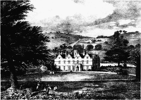
Fig. 14. Brockhampton Park from the west, c. 1840
In 1136 the bishop of Hereford granted all the other tithes in Sevenhampton together with the church there to Llanthony priory. (fn. 282) The priory later appropriated the rectory, (fn. 283) which was valued at £9 6s. 8d. in 1291, (fn. 284) and in 1366 and later it leased at least some of its tithes with its manor in Sevenhampton. (fn. 285) It retained the rectory until the Dissolution. (fn. 286) In 1545 the Crown sold the impropriate rectory together with the advowson and the priory's manor to William Berners (fn. 287) and he sold them to Joan Davis. In 1563 Joan and her husband Richard Herbert sold the estate, including the impropriation, to William Wenman and William Chandler and they divided it between themselves. (fn. 288) In 1567 Wenman and Chandler, who had unsuccessfully claimed all tithes in the parish, (fn. 289) sold their tithes from Hampen to Edward Goddard, the landowner there. (fn. 290) Wenman's moiety of the rectory was sold to Stephen Hales in 1569 and to Robert Lawrence of Shipton Solers in 1570. (fn. 291) Robert (d. 1584 or 1585) left it to his youngest son Robert (fn. 292) (d. 1644) and the latter left it to his grand-nephew Robert Lawrence, (fn. 293) who inherited Sevenhampton manor in 1645. (fn. 294) In 1689 Robert settled his share of the rectory on his son Anthony and under that settlement Anthony (d. 1717) was succeeded by his nephew Walter Lawrence. (fn. 295) From Walter (d. 1764) it descended, evidently with Sevenhampton manor, (fn. 296) to William Morris, who at parliamentary inclosure was awarded 218 a. for his share of the tithes. (fn. 297)
The other moiety of the rectory passed from William Chandler (d. c. 1614) to his son William (fn. 298) (fl. 1625). It passed from the latter to his son William (fn. 299) (d. 1652). (fn. 300) and it was acquired before 1669 by Joseph Hincksman of Salperton, possibly through his marriage to Elizabeth Chandler. (fn. 301) Joseph died in 1683 (fn. 302) and another Joseph Hincksman, who owned the same share of the estate in 1690, (fn. 303) died in 1740. (fn. 304) The share of the impropriation passed to John Hincksman, (fn. 305) after whose death in 1774 it was held by his widow Margaret apparently until their son James came of age. From James (d. 1796) (fn. 306) the estate passed to his brother John, (fn. 307) who was awarded 221 a. centred on Soundborough for his share of the tithes in 1818. (fn. 308) From John (d. 1828) the land passed to Fulwar Craven, who purchased the Brockhampton estate in 1832 and sold some of the rectory buildings and land in 1833 to W. L. Lawrence. (fn. 309) Soundborough remained a farm on the Brockhampton estate (fn. 310) and comprised over 300 a. in 1914 when Fairfax Rhodes sold it to Charles and Jesse Smith. Charles, the sole proprietor from 1917, purchased more land in 1921 and his son Edward Charles Smith sold the farm in 1964. In 1971 D. S. Gemmell doubled the farm's size by acquiring Syreford farm in Whittington and in 1980 he sold the enlarged farm to the Hon. R. I. H. Wills, Soundborough's owner in 1997. (fn. 311)
The rectory or parsonage house, which was in divided ownership from 1563, when it was called the manor house, (fn. 312) stood east of the church and among the outbuildings recorded in 1818 was a tithe barn. (fn. 313) The house and other buildings there were pulled down to make way for the new vicarage house built in 1850. The main house at Soundborough originated as a three-storeyed farmhouse built in 1837. The third storey was removed during repairs following the house's abandonment in the 1950s and the rear wing was extended in the 1970s using stone from some of the nearby farm buildings. The house was further enlarged in 1985. (fn. 314)
Economic History.
In 1086 the bishop of Hereford apparently had 2 ploughs on his demesne in Sevenhampton. (fn. 315) His livestock there in 1240 included 8 cattle. (fn. 316) In 1291 the bishop had 3 ploughlands. (fn. 317) A few years earlier 383 a. arable at Puckham and Sevenhampton was in demesne, perhaps worked as two farms; the land was valued at only 2d. an acre compared with 6d. an acre for the arable on the bishop's demesne below the escarpment in Prestbury. The bishop also had 25 a. meadow, pasture at Puckham, and 21 a. arable and 4 a. meadow at Clopley (Lower Sevenhampton) by a recent acquisition. (fn. 318) In 1289 the bishop quitclaimed a pasture close in Sevenhampton to Llanthony priory as part of an agreement under which the priory relinquished its claim to pasture oxen in his park in Prestbury. (fn. 319) Several pieces of the bishop's demesne were converted to meadow or pasture before 1390 (fn. 320) and his estate in Sevenhampton included 16 a. meadow and 12 a. pasture as well as 4 ploughlands of hilly ground in 1404. (fn. 321) In 1506 most of the demesne was in the hands of a farmer for £3 6s. 8d. a year and the demesne at Puckham was farmed separately at £1 6s. 8d.; (fn. 322) the rent from the Puckham demesne was increased to £5 before 1535. (fn. 323) Under a lease of 1531 the site of the manor and its demesne were farmed from 1537 with other land in Sevenhampton and Clopley at £6 18s. 7d.; the farmer had a right of estovers in Puckham woods. (fn. 324) In 1575, when Robert Lawrence held the site of the manor, John Cotton and William Baghot, the other lessees of demesne, held Puckham farm and Puckham woods respectively. (fn. 325) Llanthony priory administered its land at Calcombe with its Prestbury estate in 1291 (fn. 326) but its lands in Sevenhampton were let at farm in 1366 and later. (fn. 327)
In 1086 the bishop of Hereford's estate included 3 free men having 7 ploughs with their men and 21 villani with 11 ploughs. (fn. 328) About 1280 there were some 15 free tenants and 36 customary tenants on the manor. Five free tenants owed scutage for estates held by knight service, two holding 18 yardlands that formerly belonged to William of Notcliffe, William holding 6 yardlands, and the others holding 3 yardlands and a wood at Puckham respectively. The other free tenants owed cash rents and heriots. One held 4 yardlands and the rest, including Llanthony priory, had smaller estates. Of the customary tenants 17 each held 2 yardlands and owed 160 days' work a year, including the carrying of grain to Prestbury. A tenant with 1 yardland owed service as the bishop's ploughman and summer labour services. Sixteen other customary tenants between them held 301/2 yardlands for cash rents and owed payments in commutation of the service of providing firewood at the feast of St. Andrew (30 November), fish at Lady Day, and salt at Michaelmas. Another tenant with a yardland held a mill at will and had a duty to provide firewood, as did one free tenant, who, because he was not freeborn, was likewise a tenant at will. One customary tenant held two crofts of 'forelet' land, land granted only for the life of the bishop, for a cash rent. All the tenants, except those by military service, were by custom to make their ploughs available for the bishop's use. (fn. 329)
In 1340, when settlements throughout the parish were depopulated or deserted, the greater part of the arable land was uncultivated. (fn. 330) In the late Middle Ages the bulk of the bishop's income in Sevenhampton was from assized rents (fn. 331) and in 1506 some, representing over a third of their total value, were unpaid. (fn. 332) By the mid 1530s consolidation of holdings on the manor had created several large tenant estates. (fn. 333) The largest included 11 yardlands and was owned by the lords of Shipton Solers manor. (fn. 334) Two others called Okeys and Reeves, in Sevenhampton and Clopley respectively, were farmed with the site of Sevenhampton manor from 1537. (fn. 335) In 1575, when the tenants' holdings were described in a court of survey for Prestbury manor, 22 copyholds in Brockhampton, Sevenhampton, and Clopley were in the possession of 19 tenants. The commonest holdings, of which two comprised forelet land, were 1 or 2 yardlands. Five holdings had several messuages and between 3½ and 7½ yardlands each and the other tenants each held only a few acres, including some forelet land and five quarries. A yardland comprised 48 a. of open-field land. (fn. 336)
In the later 14th century, when the bishop of Hereford wintered sheep at Puckham (fn. 337) and Llanthony priory kept a flock in Sevenhampton for at least part of the year, the parish evidently included extensive sheep walks and several sheephouses. The priory reserved the hay from its meadows and tithes as fodder for its sheep and the farmer or farmers of its estate undertook to provide food for a shepherd and a dairymaid while those sheep were in the parish. (fn. 338) The farmer continued to support the priory's shepherd and pay him a stipend of 5s. in the early 15th century when the priory had a sheephouse and some pasture in hand. (fn. 339) In 1506 the bishop retained some newly inclosed meadow land at Nash in hand for feeding ewes and the profits of his manor included income from the sale of pasture rights in meadows. (fn. 340) Under a lease of 1542 the tenant of Puckham farm had to maintain eight bays ('rooms') of a sheephouse there. (fn. 341)
In the early 16th century Sevenhampton and Brockhampton had separate open fields, each set being operated on a two-course rotation. (fn. 342) In 1575, when most of the tenants of the manor had land in both sets of fields, there were at least nine or ten areas of open-field land in the centre and the northern part of the parish; references to the fields of Clopley and Nash suggest that some fields had once belonged exclusively to those hamlets but had been incorporated in the Sevenhampton field system. (fn. 343) Puckham may also have had its own fields in the late 13th century. (fn. 344) In 1531 the Sevenhampton fields were named as Quarr field, which took in land east of the river Coln, including a furlong called Oathill, and North field, which took in land to the west, including Calcombe field near Puckham woods. (fn. 345) Early inclosures were represented by the field called Blackthorns, south-east of Lower Sevenhampton, which although cultivated separately by 1503 was common pasture after the harvest, (fn. 346) and by closes at Nash, nearby Old Sennington, and elsewhere belonging to the manorial demesne in 1549. (fn. 347) In 1574 Robert Lawrence, lessee of part of the demesne, and the customary tenants inclosed and exchanged a small proportion of their lands in the Sevenhampton fields, 2 a. for every yardland (then said to contain 24 a.), to enable them to grow more grass and fodder for cattle and livestock and thereby increase the amount of manure at their disposal. (fn. 348) The Sevenhampton fields, which in the mid 17th century included Mill field to the south, Court field to the west, and Quarr field to the east, (fn. 349) continued to be worked on a two-course rotation in 1780. (fn. 350) Of the Brockhampton fields in the early 17th century North field included Rowborough furlong and other land on White hill, and South field took in land on the Hawling boundary east of Brockhampton Quarry. (fn. 351) The area of the Brockhampton fields was also reduced by piecemeal inclosure, most of which apparently took place after 1700. (fn. 352)
In 1503 freeholders and customary tenants in Sevenhampton and Brockhampton had common rights in their respective fields for a horse, 4 cattle, and 40 sheep for each yardland. They also had common rights for horses and cattle on waste land in the fields belonging to the lord of the manor. (fn. 353) In the 16th and 17th centuries many sheep and smaller numbers of cattle were pas- tured (fn. 354) and there were large commons on the hills and downs in the outlying parts of the parish. (fn. 355) In the west, West Down was part of an extensive common centred on Cleeve hill in Bishop's Cleeve parish to the north-west. (fn. 356) Arbitration in 1581, following disputes over common rights there, assigned that part of West Down adjoining Puckham woods, to the south, to Robert Lawrence for the term of his lease of demesne land and granted the Brockhampton copyholders pasture rights on the rest of the common, as far as Wontley wood, for the same period. (fn. 357) Later the part adjoining Puckham woods was a several sheep sleight, belonging to the manor (fn. 358) and, from 1638, to the Brockhampton estate, (fn. 359) and the common included only a narrow strip of land within Sevenhampton, along the parish boundary; in 1676 separate parts were open to the Sevenhampton and the Brockhampton commoners. (fn. 360) Puckham woods, which were partly in Prestbury, (fn. 361) had been used as a common in the 1270s (fn. 362) and the tenants of Sevenhampton manor had a customary right to graze horses and cattle but not sheep throughout the year in them in 1503. (fn. 363) Although in 1565 the Sevenhampton tenants denied that the Prestbury tenants had common rights in the woods, (fn. 364) it was intercommoned by livestock from both parishes until it was inclosed under an agreement of 1657, which allotted c. 80 a., mostly on the east side of the valley, as a common for the landholders of Sevenhampton and Brockhampton. (fn. 365) The bounds of the common were slightly varied in 1669 on an exchange between landowners and the individual coppices on it were closed to horses and cattle during the first seven years' growth. (fn. 366) An agreement of 1704 reduced the number of cattle grazing in the woods (fn. 367) and in 1728 the manor court ordered local landowner and farmer Thomas Bastin to supervise the commoners' building of a wall to exclude sheep from the common. (fn. 368)
On the south side of the parish a large common in Hampen bottom was used for pasturing both sheep and cattle in the later 17th century. Its boundary with the Hampen estate, to the east, was known as the 'great mere' but pasture rights on the eastern side of the bottom, where there was a watering place called Black wells, were disputed by the estate's owners (fn. 369) and, by agreement with the commoners in 1709, Goddard Carter built a wall as a new boundary for the estate. (fn. 370) A wall was built to mark its southern boundary under an agreement of 1780 (fn. 371) and the common, although described in 1713 as a cow pasture, (fn. 372) was grazed by sheep in the late 18th century. (fn. 373) Brockhampton's commons were on the downs in the northern part of the parish, where, in the far north, an area known as 'new broke lands', adjoining Hawling, was brought into cultivation before 1624. The Oxleaze, a pasture below the Hawling boundary east of Brockhampton village, may have been used as a sheep pasture in the early 17th century, (fn. 374) but an agreement of 1650, under which eight landholders in Brockhampton inclosed parts of it and some small woody areas on Bespidge hill, regulated its use as a cattle pasture and designated the remaining common land on White and Bespidge hills sheep pastures. (fn. 375) In the late 18th century the common on Bespidge hill adjoining Roel Gate was used as a cow pasture. (fn. 376)
In the later 17th century and the early 18th parts of the open fields were tilled every year and it had long been accepted practice to plough up parts of the commons, including the Oxleaze, for a number of years. (fn. 377) The hills at Hampen, where Goddard Carter employed a shepherd, were devoted mainly to pasture but corn was also grown there. (fn. 378) Puckham farm continued to be used primarily for raising sheep and cattle, the owner in the 1680s removing his sheep from the parish during the lambing and shearing seasons to avoid paying tithes, (fn. 379) and in the mid 18th century, although in divided ownership, it remained a single farm, worked by the Bastin family. (fn. 380) In the mid 18th century the Tracys' estate included farms worked from houses at Lower Sevenhampton, Oxleaze, and Whitehall (fn. 381) and cottages at Brockhampton held under leases for terms of three lives. (fn. 382) By 1778 Whitehall farm was worked together with a farm in Bishop's Cleeve. (fn. 383)
Pressure on the shrinking area of common land was perhaps felt as early as 1612 when the manor court sought to exclude from the parish in winter sheep which had not spent the summer there. In 1656 the court ordered a reduction in the number of sheep for the next two years (fn. 384) and in 1675 the lord of the manor and the commoners agreed to put fewer animals on the commons for the next eight years. The agreement, which reduced the number of sheep by a third, (fn. 385) was repeated later and the number of sheep allowed on the commons continued at the lower level, if perhaps intermittently, until after 1776. (fn. 386) Under an agreement of 1780 for the management of the Sevenhampton fields and commons the commoners hired a single shepherd to look after their flocks. (fn. 387)
In the mid 1770s the parish was described as being principally in tillage (fn. 388) and in 1801 930 a. was returned as growing arable crops, mainly wheat, oats, barley, and turnips. (fn. 389) Several of the Sevenhampton fields were uninclosed in the early 19th century, including Lower, Elsdown, Down Furlong, Blackthorn, and Oathill fields east of the river Coln, Upper and Lower Bentil fields south of the park, and Little, Lower, and Great Calcombe fields west of the road from Syreford to Cleeve common. At that time nearly 200 a. in the west of the parish was common land, including part of Puckham woods and heavily-pitted land to the east that had been part of the open fields and was known as the slate common and the little slate common. (fn. 390) In the south-east Hampen common covered 152 a. Brockhampton retained rather less open-field land, but 195 a. on White and Bespidge hills remained common land, known as Bespidge common, and there were two much smaller commons, Lower and Upper Oxleaze, to the south, nearer Brockhampton village. The inclosure of the parish was completed under an Act of 1814 and the commissioner's award, dated 1818, dealt with many old inclosures as well as the open fields and commons and commuted all the tithes for land. Of the main beneficiaries Rebecca Lightbourne received 563 a., William Morris 491 a. (including 20 a. for an estate held in trust for his son W. L. Lawrence), and John Hincksman 320 a. The 78 a. awarded to the dean and the precentor of Hereford was reduced to 71 a. on an exchange with James Agg, who received 13 a. Three other landowners were awarded 18 a., 2 a., and 1 a. respectively. (fn. 391)
In the early 19th century the majority of families in the parish, 62 out of 74 in 1811 and 58 out of 103 in 1831, were employed chiefly in agriculture. (fn. 392) Following inclosure Rebecca Lightbourne's estate had four farms with over 200 a. each in Sevenhampton, the largest (380 a.) centred on Oxleaze and the others on Brockhampton, Whitehall, and Lower Sevenhampton. (fn. 393) Later, by 1833, the Lawrence family's estate had two much larger farms, one centred on Sevenhampton and the other on Whitehall. (fn. 394) In 1851 the largest farm in the parish comprised 780 a. and employed 31 men and children, and the other farms employing ten or more labourers had 550 a., 540 a., 430 a., 400 a., and 256 a. (fn. 395) Seventeen agricultural occupiers were returned in 1896. Nearly all were tenant farmers but one was a freeholder and smallholder. (fn. 396) Of the 17 holdings returned in 1926, three had over 300 a., four over 150 a., one over 100 a., and seven under 20 a. Eleven, including the three largest, were in the hands of tenants and there were 38 agricultural labourers in regular employment. (fn. 397) Of the fifteen farms returned for the parish in 1956 two had over 300 a., three over 150 a., and eight under 50 a. Twelve farms were returned in 1986, one with over 741 a. (300 ha.), another with over 494 a. (200 ha.), a third with over 247 a. (100 ha.), and the rest with under 74 a. (30 ha.). During the later 20th century the number of labourers regularly employed on Sevenhampton's farms fell and more agricultural work was undertaken by contractors. Six hired labourers were returned as having regular employment in Sevenhapton in 1986, when one of the larger farms was run by a manager and the smaller holdings were all worked by part-time farmers. (fn. 398) In 1997 Manor farm, worked since 1899 by Benjamin Thomas Hyatt and his descendants, comprised c. 195 ha. (483 a.) and Whitehall farm, also worked by its owners, c. 162 ha. (400 a.). (fn. 399)
Three shepherds lived in the parish in 1851, one of them at Hampen, (fn. 400) where T. B. Browne raised large flocks and conducted sheep sales in the 1850s and 1860s. (fn. 401) In 1866, when 1,186 sheep, 264 cattle including some milch cows, and 78 pigs were returned for the parish, (fn. 402) some 2,274 a. was planted with crops, including grass seeds, a few acres were fallow, and 592 a. was permanent grassland. (fn. 403) Later in the century the area devoted to cereals was reduced and land turned to permanent pasture, and in 1905 the parish had 1,358 a. of arable and 1,313 a. of permanent grassland. Those proportions remained much the same in 1926, when 590 a. was described as rough grazing. Only 699 sheep were returned for the parish in 1896 and 542 breeding ewes in 1926. Beef animals accounted for most of the 227 cattle returned in 1896. In the early 20th century stock rearing and pig farming increased, 497 cattle and 163 pigs being returned in 1926, and large-scale poultry farming was introduced. In the late 19th century horses were bred and reared in Sevenhampton (fn. 404) and in the 1920s and 1930s the profitability of Manor farm, which was then devoted to raising sheep and cattle, depended on the sale of carthorses and hunters. (fn. 405) In 1956, when only 347 a. was returned as growing corn and 39 a. as fallow, 749 a. was described as permanent grassland and at least 1,017 a. was used as pasture; the livestock returned that year included 454 ewes, 621 beef and dairy cattle, 221 pigs, and 2,328 poultry. (fn. 406) In the 1970s and 1980s more land was used for cereals and more sheep were kept and Manor farm, on which dairy cows had been bred earlier, maintained a herd of up to 280 cattle. In 1986, when 1,470 a. (595 ha.) was returned as growing corn, 598 a. (242 ha.) was described as grassland and 158 a. (64 ha.) as rough grazing and the livestock in Sevenhampton included 1,012 ewes and 288 beef cattle. In the late 1990s, when most of the farms continued a mixed economy, Manor farm had 200 ewes and c. 160 beef cattle and Whitehall farm supported a herd of beef cattle. (fn. 407)
A water mill recorded in Sevenhampton in the late 13th century (fn. 408) was held at will from the bishop of Hereford c. 1280. (fn. 409) In 1337 Roger of Breinton was licensed to grant the bishop a mill, almost certainly at Clopley, as part of an endowment for an obit for Richard Swinfield, a former bishop, (fn. 410) and in 1404 the bishop's estate had a ruined water mill. (fn. 411) That or another water mill was later let to a tenant, but the rent was unpaid in 1506 (fn. 412) and its site, which was forelet land, (fn. 413) was among the land acquired by Reginald Nicholas and Richard Wardwick in 1576. (fn. 414) A water grist mill operated in Sevenhampton in 1669 (fn. 415) and field names recorded in 1818 indicate that a mill once stood on the Coln downstream of Lower Sevenhampton towards Syreford. (fn. 416)
The Cotswold slate outcrop in the west of the parish was quarried for roofing material, perhaps as early as Roman times. (fn. 417) In 1404 the bishop of Hereford's Sevenhampton estate had two quarries, both of which had been worked for ragstone and stone tiles. (fn. 418) One may have been Nash quarry, east of Puckham, which was recorded in the late 1380s (fn. 419) and paid rent to the manor in 1506. (fn. 420) Place names recorded in the mid 16th century suggest that lime had once been made at several sites on that side of the parish. (fn. 421) Slate quarrying was an important source of income for the manor in 1630 (fn. 422) and, although one slate digger undertook in 1648 not to quarry in the commons or fields of Sevenhampton, (fn. 423) it continued intermittently. (fn. 424) In 1781 seven men with quarries on common land, five of them from parishes neighbouring Sevenhampton and two from Winchcombe, agreed to pay the lord of the manor a royalty and he undertook to prosecute people taking stones and slates without their consent. (fn. 425) In 1997 old workings were clearly visible in those areas east of Puckham woods known in the early 19th century as the slate common and the little slate common. (fn. 426) Several small pits had been reopened there in the late 1940s (fn. 427) and the most recently abandoned workings were to the north at Puckham Scrubs, by the road to Cleeve common. (fn. 428)
In the later Middle Ages there were important quarries in Brockhampton. Llanthony priory used stone from one to repair a bridge near Cheltenham in 1481 or 1482 (fn. 429) and the prior, along with the abbots of Winchcombe and Evesham and others, owed rents to the manor in the early 16th century for quarries there. (fn. 430) The manor's Brockhampton quarries, of which three were recorded in 1575, (fn. 431) were sold in 1591. (fn. 432) The main area of quarrying was on the hillside at Brockhampton Quarry, where the depth of the workings is indicated by the survival in the summer of 1635 of snow and ice from the previous winter. (fn. 433) At that time the quarries supplied freestone over a wide area, including Gloucester, and they were also a source of Cotswold slates or tiles. (fn. 434) Two masons were listed in Brockhampton in 1608 (fn. 435) and members the Denley family, masons resident at Brockhampton Quarry from the mid 18th century, became active in quarrying in neighbouring parishes. (fn. 436) At least four masons lived at Brockhampton Quarry in 1851 (fn. 437) but the main quarry there had been abandoned by the early 1880s. (fn. 438) It provided stone for a new house built nearby in the early 1930s. (fn. 439)
In the late 1930s there was a large quarry in the east of the parish at Soundborough. (fn. 440) It was worked for stone to make roof slates in the late 1940s (fn. 441) and it was a source of undressed building stone in the late 1990s. (fn. 442) Building stone was excavated on a small scale in the centre of the parish until the mid 1970s. (fn. 443)
Early evidence for trades and crafts other than those connected with stone working is slight. The washing or soaking of flax and hemp in the Coln in 1646 (fn. 444) may have been part of a local industry for which no other evidence survives. A blacksmith was recorded in 1669 and a cordwainer in 1694. (fn. 445) In 1770 a Shipton carpenter and wheelwright took a lease of a barn known as Sheephouse barn and undertook to convert it as a cottage and his workshop. (fn. 446) Building and other village trades were well represented at Brockhampton and, to a lesser extent, Brockhampton Quarry in the 18th and 19th centuries. (fn. 447) There was also a smithy at Lower Sevenhampton in 1818 (fn. 448) and another at Upper Sevenhampton operated in the later 19th century. (fn. 449) A machine maker at Lower Sevenhampton in 1823 moved to Brockhampton. (fn. 450) John Wood, a baker, built a malthouse in Brockhampton village in 1769 (fn. 451) and George Combe (d. 1871) established a brewery in an outbuilding to the west after he bought it in 1853. (fn. 452) The brewery closed in or soon after 1921 (fn. 453) and, after malting ceased some years later, the malthouse was used for a time to dry grain. (fn. 454) Brockhampton had a shopkeeper in the mid 18th century (fn. 455) and there were also shopkeepers in some of the smaller hamlets in the 19th century. A carrier at Brockhampton Quarry provided a service to and from Cheltenham in the 1850s (fn. 456) and there was a post office in Brockhampton in the early 1880s. (fn. 457) Among the less usual tradesmen recorded in the parish was a corn factor in 1784. (fn. 458) In the mid 19th century one Brockhampton man was described variously as a chemist (fn. 459) and a surgeon and dentist, and other Brockhampton residents included a gardener and a tree planter. (fn. 460) Some village trades, including those of blacksmith and carrier, survived at Sevenhampton and Brockhampton in the 1930s (fn. 461) and traditional crafts were practised by a saddler and a stone waller in the late 1970s. (fn. 462) The parish retained a number of shops in the 1930s (fn. 463) but they all closed later. In 1997 Brockhampton village hall accommodated a post office.
In 1850 T. B. Browne, who patented several innovations in weaving, provided new buildings for a flax mill on the parish boundary at Hampen and for a few years manufactured sacking and hoses there. (fn. 464) Browne, who devised several schemes for employing country people, (fn. 465) also operated the factory as a bone mill in 1856. (fn. 466) A few years later he handed it over to a local farmer, (fn. 467) who ran it solely as a bone mill producing fertilizer and artificial manure. (fn. 468) The factory was abandoned in the late 1880s. (fn. 469)
Local Government.
In 1287 the bishop of Hereford claimed view of frankpledge in the manor of Sevenhampton and, by a grant of Henry III, exemption for his men there from suit of shire and hundred courts for all pleas except those belonging to the Crown. (fn. 470) In 1394 the bishop was granted assize of bread, wine, ale, and other victuals and assay and sealing of measures and weights on his estates. (fn. 471) Although the bishop's Prestbury courts apparently dealt with matters relating to Sevenhampton until at least the 1530s, (fn. 472) two court sessions were held in Sevenhampton in 1506. (fn. 473) Court rolls from the years 1573–4 and 1609–98 are among surviving manorial records for Sevenhampton. (fn. 474) By the later 16th century the manor court evidently met once a year, in the spring, to combine the business of the view of frankpledge with that of a court baron. In the 17th century it enforced the assize of ale and on at least one occasion an incidence of bloodshed was reported to it. The court also dealt with the harbouring of strangers and had the usual concern for roads, watercourses, and bridges. In dealing with agrarian matters, including, in the late 16th century, inclosure of land, it regulated common rights, electing four men as sheep or beast tellers, and ordered the inhabitants to repair the common pound. It also acted against encroachments on the lord's waste land.
The parish had two churchwardens in 1543 and later, (fn. 475) although by the early 18th century there was often only one. (fn. 476) In the 17th century the manor court elected the constable and the duty of filling that office possibly rotated among landholders. The court also elected two surveyors of the highways for the parish, and in 1656 it sought to control the use of the church house as a poorhouse. (fn. 477) Poor relief was administered by one overseer of the poor in 1720 (fn. 478) and by two overseers in 1803. (fn. 479) Its cost rose from £82 in 1776 to £258 in 1803, when 46 people were receiving assistance. (fn. 480) Ten years later slightly less was spent on providing help for half that number (fn. 481) and in the later 1820s and early 1830s the annual cost was usually below £180. (fn. 482) Sevenhampton was included in Northleach poor-law union in 1836, (fn. 483) and the whole of the parish was in Northleach rural district from 1895 (fn. 484) until 1935 when the area lost to the new civil parish of Sudeley was transferred to Cheltenham rural district. (fn. 485) At local government reorganization in 1974 the remainder of Sevenhampton became part of Cotswold district and Sudeley part of Tewkesbury district.
Church.
In 1136 Sevenhampton church, then described as the church of Prestbury on the hills, was given by Robert, bishop of Hereford, to Llanthony priory. (fn. 486) The priory had the church, a rectory, in its gift in the mid 13th century and, as the incumbent conceded in 1264, received a pension of 40s. from it. (fn. 487) In 1275 the priory was permitted to appropriate the rectory by virtue of the church's status as a dependent chapel of Prestbury. (fn. 488) In the late Middle Ages the appointment and maintenance of a chaplain or curate for the church rested with farmers of the priory's Sevenhampton estate; (fn. 489) a chaplain taking a lease of the estate in 1383 was required to serve in person or to provide someone suitable in his place. (fn. 490) The owners of the impropriate rectory nominated curates after the Dissolution (fn. 491) and the benefice, called a vicarage in the mid 16th century, (fn. 492) became a perpetual curacy following several endowments in the 18th century. (fn. 493) Later also known as a vicarage, (fn. 494) it was united with Charlton Abbots in 1929. (fn. 495) Hawling was added to the united benefice in 1953 and Whittington in 1975. (fn. 496) From 1996 Sevenhampton was one of eight parishes served by a priest-in-charge living in Shipton Oliffe village. (fn. 497)
After the division of the rectory estate in 1563 (fn. 498) the two impropriators usually, if not always, made joint nominations to Sevenhampton church, (fn. 499) as in 1766 when John Lawrence, to whom his father Walter (d. 1764) had willed the curacy at that vacancy, was their nominee. (fn. 500) The bishop, who nominated by reason of lapse in 1851 and 1872, (fn. 501) acquired the patronage from C. W. Lawrence and G. C. Colquitt-Craven in 1888. (fn. 502) At the union of benefices in 1929 he obtained the advowson for two of every series of three turns (fn. 503) and from 1953 he shared the patronage with E. W. W. Bailey. (fn. 504) At the union of 1975 the bishop and three other parties were awarded a joint right of presentation. (fn. 505)
In the 1530s, and presumably earlier, the Sevenhampton curate received a salary or stipend from the farmer of Llanthony priory's estate. (fn. 506) A stipend paid later by the impropriators (fn. 507) was £8 in 1603 (fn. 508) and had been raised to £10 by the early 18th century. (fn. 509) Each impropriator paid half of the stipend and at parliamentary inclosure in 1818 their payments were fixed as rent charges on land allotted to them. (fn. 510) Joshua Aylworth of Aylworth, in Naunton, by deed of 1715 gave £200 in trust to augment the curate's income. (fn. 511) A similar sum left by Sir William Dodwell by will proved 1728 (fn. 512) was used for the same purpose and was matched in 1730 by a grant from Queen Anne's Bounty. (fn. 513) Goddard Carter by will proved 1725 left a rent charge of £5 from land at Hampen for a person appointed by his successors to read Sunday morning prayers in the church; (fn. 514) at the end of the century it was paid to the curate. The curate's income from that and from the other three gifts mentioned here was £39 15s. in 1807. (fn. 515) From 1810 the curacy was augmented several more times by Queen Anne's Bounty (fn. 516) and in 1828 it owned 24 a. in Withington. (fn. 517) Its value in 1856 was only £50. (fn. 518)
There was no house attached to the living until the mid 19th century. (fn. 519) Edward Ellerton, curate from 1825, acquired a house standing south-east of the churchyard and in 1846, when it was occupied by his stipendiary curate, he gave it to Queen Anne's Bounty in exchange for an augmentation of the living. (fn. 520) The house and other houses and buildings near by were demolished to make way for a parsonage that Ellerton built in 1850 next to the churchyard and set back from the road. (fn. 521) That house, retained for the united benefice in 1929 and 1975, (fn. 522) was sold in the mid 1990s. (fn. 523)
Among the earliest known curates was John Hanley, who in 1551 was unable to recite the Ten Commandments. (fn. 524) Until the mid 19th century the curates usually served one or more churches besides Sevenhampton and many held neighbouring benefices. In the mid 1560s Miles Busted, who was then also curate of Salperton, officiated in person but some services were performed by the rector of Whittington. (fn. 525) Busted (d. 1584) was succeeded as curate of Sevenhampton by William Busted. (fn. 526) The curate in 1593 was described as a sufficient scholar but no preacher. (fn. 527) The curate named in 1642 (fn. 528) lived in Brockhampton in 1650. (fn. 529) Following the Restoration the church was served by a succession of clergy including the rector of Whittington for much of the 1660s and the curate of Salperton in the early 1670s. (fn. 530) In the mid 1680s the rector of Hawling had the curacy of Sevenhampton, and in the 18th century the two benefices were held together for several periods (fn. 531) and services alternated between the two churches. (fn. 532) In 1768 John Lawrence, who had been appointed to both benefices in 1766, resigned Hawling and became curate of Salperton but from 1772 and until his death in 1808 he held all three benefices. William Pearce, his successor at Sevenhampton and Salperton, lived in Sevenhampton and served both parishes; in 1811 he was licensed to be absent for two years. (fn. 533) Pearce retained Sevenhampton after becoming vicar of Leigh in 1813, but after a few years he took up residence in Staverton and placed stipendiary curates in charge of Sevenhampton. Stipendiary curates were also appointed by the next perpetual curate, Edward Ellerton, 1825–51, who was an Oxford don. (fn. 534) At the end of his incumbency Ellerton provided a parsonage or vicarage house (fn. 535) and his successors were usually resident. (fn. 536) From 1996 the church was served by a non-resident priest (fn. 537) and in most weeks in 1997 it had one Sunday service.
In 1365 Llanthony priory granted a lease of a house and its lands in Brockhampton by the service of maintaining a lamp in Sevenhampton church. (fn. 538) Land in Sevenhampton given to support a lamp in the church passed to the Crown and was granted to Sir Edward Warner in 1561. (fn. 539)
The church, which bore a dedication to ST. ANDREW by 1503, (fn. 540) comprises chancel, central tower, north and south transepts, and nave with south porch. (fn. 541) The cruciform plan and some of the surviving fabric date from the 12th century; the lintel of the nave south doorway has chevron decoration and the west end pilaster buttresses. A substantial rebuilding took place in the 13th century, the lancet windows in the chancel and south transept and a blocked one in the nave being from that period. Before its rebuilding in 1892 the east wall of the chancel also contained evidence of former lancets; (fn. 542) shafts in the reveal of the south transept south window in 1863, (fn. 543) crudely altered to receive them, could have come from there. Larger traceried windows replaced the east window, the north-east and south-east chancel windows, and the west window in the 14th century. For part of that century the entire church was evidently maintained by Llanthony priory or the farmers of its Sevenhampton estate (fn. 544) but by the end of it the priory or its lessees were only concerned with the repair of the chancel; (fn. 545) after the Dissolution the lay rectors became responsible for the chancel's fabric. (fn. 546) In the late 15th century or the early 16th the slender tower, with a tierceron vault on angel corbels, was inserted into the larger crossing by means of flying buttresses from the west walls of the crossing, (fn. 547) the south porch was added, the south side of the church was much rebuilt in squared limestone, and several new windows were installed. Those alterations were partly paid for by John Camber (d. 1498), a Worcester wool merchant, who left 100s. for work on the church. Camber was buried in the church (fn. 548) and in 1535 funds for an anniversary commemoration of his death came from property in Prestbury. (fn. 549)
New doors and seats were installed during repairs carried out in 1771 and 1772 under the direction of the incumbent John Lawrence. His brother Walter, who supplied a deficit in funds from subscriptions, donated a number of fittings and furnishings. (fn. 550) The chancel was overcrowded in 1807 (fn. 551) and the church remained cluttered, with tall pews facing in all directions and the altar barely visible from the nave, until it was restored and repewed in 1892 and 1893 to plans by F. W. Waller. During the restoration, which was partly at the expense of the Lawrence family, the chancel was reroofed and its east wall rebuilt, chimney stacks were built on the north side of the chancel and nave, most of the windows were reglazed, and a vestry was formed at the west end of the nave. Soil that had accumulated against the walls was removed and the churchyard levelled in places. (fn. 552) Among the new church fittings was a font given by Agatha Lawrence; (fn. 553) the baluster font it replaced, dating probably from the Restoration and described in 1863 as wretched and modern, (fn. 554) was used for floral displays in the church in 1997. A small organ stood in the north transept from 1974. (fn. 555)
Of the church's three bells the oldest dates from the 15th century, the treble, the gift of William Chandler, was cast by John Pennington in 1650, and the third was recast at the Rudhalls' foundry in Gloucester in 1718. (fn. 556) The plate includes a paten of 1716 obtained by gift from Mary Lawrence (d. 1717) and a chalice and paten cover of 1731 acquired in 1732. (fn. 557) John Camber is commemorated by a brass in the chancel; it was formerly on the floor there. (fn. 558) The chancel also contains a stone monument to William Chandler (d. 1652), a wooden memorial to Anna (d. 1653), wife of John Carter of Charlton Abbots, (fn. 559) brasses to members of the Lawrence family in the later 17th century, and later memorials to members of both the Lawrence and Hincksman families. Of the glass memorials in the chancel only one was installed before 1892 (fn. 560) and two date from the mid 1990s, one of the latter depicting the church in an agricultural scene. The south transept windows contain memorial glass of the later 19th century and the early 20th. The earliest memorials in the north transept, where owners and occupants of Brockhampton Park sat, are marble wall monuments to Sir William Dodwell (d. 1727) and the Revd. John Craven (d. 1804); its windows contain early 20th-century glass memorials. In the churchyard near the porch is a group of richly carved tombchests and headstones of the later 17th century and the 18th. (fn. 561) The surviving parish registers, which begin in 1588 and include entries for Charlton Abbots in the 17th and 18th centuries, contain few marriages between 1716 and 1755. (fn. 562)
Nonconformity.
Although Baptists from Bourton-on-the-Water and elsewhere held a meeting at Brockhampton in 1660, (fn. 563) no nonconformists were recorded among Sevenhampton parishioners in 1676. (fn. 564) A house in Brockhampton was registered for nonconformist services in 1813 (fn. 565) but that meeting was short lived. (fn. 566) In 1833 Baptists led by James Smith, a minister in Cheltenham, were active there and the following year they built a chapel called Bethel at Brockhampton Quarry; (fn. 567) in 1837 their Sunday school taught 60 children and was connected with Salem chapel in Cheltenham. (fn. 568) The chapel became Particular Baptist and in 1851 its congregation was fewer than 50 and its minister lived in Withington. (fn. 569) Another Baptist meeting in Brockhampton was associated with Salem chapel in the late 1840s (fn. 570) and it built a chapel in the village in 1850. That chapel, known as Salem, had a congregation said in 1851 to number up to 100 (fn. 571) and was General Baptist in the later 19th century. (fn. 572) It was rebuilt in 1861 (fn. 573) and had a new schoolroom added to it in 1920. (fn. 574) It closed in 1990 and was converted as a house. The Brockhampton Quarry chapel, which had remained open until the 1960s, was also a house in 1997. (fn. 575)
Wesleyan Methodists from Cheltenham began holding services at Hampen hill in 1861 but abandoned them in 1865 in favour of other missions to the area. (fn. 576)
Education.
In 1813 a schoolmaster lived in the parish (fn. 577) and in 1818 Sevenhampton had two or three day schools teaching c. 20 children and a Sunday school with c. 40 pupils. (fn. 578) Twenty children from the parish also attended day school in 1825. (fn. 579) From 1830 children went to a day school in Whittington opened by the trustees of Rebecca Lightbourne's charity and the Sunday school received £2 a year from the charity. (fn. 580) The Sunday school, which was also supported by subscriptions, was united to the National Society and it taught 55 children in 1833 and 49 children in 1847; in the latter year it was held in the church. (fn. 581) In 1845 a schoolmaster was among Brockhampton's residents (fn. 582) and in 1851 Sevenhampton and Brockhampton each had a dame school. (fn. 583)
In 1855 a day school was established in Sevenhampton under the management of the perpetual curate Charles Chambers. Supported by voluntary contributions and pence, it occupied the same room as the Sunday school (fn. 584) in a small building behind the vicarage house. In 1864 Georgina Maria Craven provided a new schoolroom built in Brockhampton village partly by subscription and she took over the management of the day and Sunday schools, (fn. 585) but in 1868 the incumbent G. E. F. Masters reopened the Sevenhampton schoolroom and the Lightbourne charity resumed its grant, discontinued in 1865, to the Sunday school; the grant was paid until 1872. (fn. 586) The church day school, which in 1869 had 38 infant and junior pupils in a single department, (fn. 587) moved in 1870 to a new building on the lane from Lower Sevenhampton to Brockhampton; the site was given by W. L. Lawrence (fn. 588) and the building designed by D. J. and R. Humphris of Cheltenham. (fn. 589) The school in Brockhampton closed in 1869 (fn. 590) and its room was later used as a reading room. (fn. 591) The church school taught children from Sevenhampton and Charlton Abbots (fn. 592) and had an average attendance of 60 in 1889 (fn. 593) and 81 in 1904. (fn. 594) Later known as Sevenhampton C. of E. school, it had infant and mixed junior classes and was supported by the Lawrence and Rhodes families in the early 20th century. The school building was enlarged in 1912 (fn. 595) but the average attendance was 62 in 1922 and fell to 35 in 1938. (fn. 596) From 1946 the school took children from Salperton (fn. 597) and in 1958 it had 39 children on its roll. (fn. 598) It closed in 1974 (fn. 599) and the building was converted as a house.
Charity for the Poor.
By deed of 1720 Hester Mitchell and her son Thomas Longford gave a 20s. rent charge from a close called Dunnwell (later Dunnywell) for a bread dole four times a year to ten parishioners, including five widows. (fn. 600) The charity was distributed only at Christmas by the late 1820s (fn. 601) and the recipients were given bread until the 1950s. The rent charge was redeemed in the late 1960s and a Scheme of 1972 permitted the charity's distribution of doles in kind or cash. (fn. 602) The charity was wound up in 1989 and its funds were given to a local old people's club. (fn. 603)