A History of the County of Gloucester: Volume 9, Bradley Hundred. The Northleach Area of the Cotswolds. Originally published by Victoria County History, London, 2001.
This free content was digitised by double rekeying. All rights reserved.
'Parishes: Dowdeswell', in A History of the County of Gloucester: Volume 9, Bradley Hundred. The Northleach Area of the Cotswolds, (London, 2001) pp. 42-69. British History Online https://www.british-history.ac.uk/vch/glos/vol9/pp42-69 [accessed 25 April 2024]
In this section
DOWDESWELL
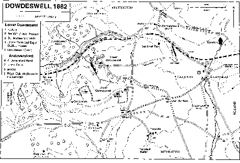
Fig. 2: Dowdeswell, 1882
Dowdeswell parish, which formerly included most of the hamlet of Andoversford, lies at the edge of the Cotswold escarpment 6 km. south-east of Cheltenham. It was recorded from the late 8th century a.d. as 'Dogodeswellan', (fn. 1) presumably the name of one of the springs that rise there and combine to form the river Chelt. In the mid 8th century an abbot called Headda inherited an estate at Dowdeswell and was also granted an estate at Andoversford ('Onnanforda'), (fn. 2) those two estates possibly comprising the whole of the later parish of Dowdeswell, which covered 2,246 a. (909 ha.). (fn. 3)
The eastern end of the ancient parish (fn. 4) was at a place called Hannington hill (fn. 5) on the StowGloucester road east of Andoversford; the hill was presumably the 'Onnandunam' which marked the east boundary of the Andoversford estate granted to Abbot Headda and which gave its name to the whole of that estate c. 790 a.d. (fn. 6) The south boundary of the parish crossed the river Coln at the ford at Andoversford and followed the Stow-Gloucester road up to its junction with the main Oxford–Gloucester road at a place called by the late 18th century Kilkenny. (fn. 7) From there the boundary branched away southwestwards along Ratshill bank (apparently called Norden bottom in 1681) (fn. 8) and Bogdon bank, taking in an upland area called Pegglesworth. Beyond Pegglesworth the west boundary of the parish followed a valley called Chatcombe, a name recalling 'cattes hlinc', which was mentioned as a landmark c. 1000 a.d. when Dowdeswell was perambulated as part of the bishop of Worcester's Withington estate. Further north the boundary followed a stream down the side of the valley of the river Chelt to cross the river at the bottom of the valley; stream and crossing were probably those recorded as 'maerbroc' and 'maerforda' (boundary brook and boundary ford) c. 1000 a.d. (fn. 9) The north boundary of the parish is partly on an old Charlton Kings to Whittington road, and, in returning to Andoversford, it followed ancient field boundaries, which are mostly no longer apparent as a result of the enlargement of Sandywell park and the building of a new Cheltenham to London road in the 1820s and the building of a railway later in the 19th century.
After Dowdeswell became established as a separate parish, distinct from Withington, land called Rossley (c. 102 a.) on the south side of the Chelt valley remained a detached part of Withington until Dowdeswell absorbed it in 1883. (fn. 10) Land in Foxcote common meadow within Withington parish, amounting to 3 a. in 1819 after the inclosure of the meadow, was a detached part of Dowdeswell, (fn. 11) presumably until the implementation of the Divided Parishes Act of 1882. In 1956 426 a. at the east end of the parish was included in a new civil parish of Andoversford, which also took parts of Withington, Whittington, and Shipton. (fn. 12) The following account covers the ancient parish of Dowdeswell together with Rossley, and it includes the whole of Andoversford hamlet, where some buildings stood just within the adjoining ancient parishes.
Dowdeswell includes one of the highest parts of the Cotswold escarpment, the land reaching 298 m. just west of Pegglesworth Home Farm and 289 m. further east at Cold Comfort hill, so called by the mid 17th century (fn. 13) from its exposed situation. Further north the land falls steeply to the valley of the river Chelt, which lies at around 140 m., and to a side valley formerly called the Coombs; (fn. 14) beyond the Chelt the land rises steeply again to reach c. 230 m. at the north boundary. The lowest part of the parish, in the Chelt valley, is on the Lower Lias clay and the sides of the valleys are formed of the Middle and Upper Lias clays and sands, with an intervening band of marlstone. The high ground is formed mainly by the Inferior Oolite and the two highest points by caps of the Great Oolite above a band of fuller's earth. (fn. 15)
The river Chelt rises just west of Sandywell park and is augmented by springs emerging on the north side of the valley at Woodlands farm and Dowdeswell wood and on the south side of the valley at Upper Dowdeswell (near the head of the Coombs), Rossley, and Lineover wood. (fn. 16) Plans to employ the Chelt's headwater springs to supply Cheltenham with water were discussed from the 1830s (fn. 17) and were realized between 1883 and 1886 when the Cheltenham borough corporation built the Dowdeswell reservoir, (fn. 18) formed by a dam constructed across the valley bottom near the west boundary of the parish. The water treatment plant below the dam was improved by the installation of mechanical filters in the years 1924–5, (fn. 19) and in the late 1920s the corporation bought much of the Dowdeswell manor estate to safeguard the sources of supply to the reser- voir. (fn. 20) In 1998 the reservoir was no longer used for water supply and its owners, Severn Trent Water Ltd., were preparing to convey it to the Environment Agency to be maintained as a flood defence and nature reserve. (fn. 21)
The slopes of the Chelt valley are well wooded. Dowdeswell wood, which occupies the bulk of the land within the parish on the northern slopes and before the reservoir was built extended southwards to the main Cheltenham– London road, covered 159 a. in 1838. (fn. 22) Woodlands farm, adjoining on the north-east, was probably an assart from Dowdeswell wood, taken out before 1632 when a group of closes, including three called the Woodlands grounds, were recorded there. (fn. 23) Lineover wood, Acres grove, and Red wood, occupying part of the slopes of the Chelt valley, south-west of Rossley, covered 76 a. in 1838, and there were some smaller groves on the hillside further east. From the early modern period all the woods of the valley sides belonged in severalty to the Dowdeswell manor estate, which, by 1641, also included a wood called Ayles wood by the southwest boundary. Ayles wood was originally part of a larger wood of that name, mainly in the adjoining Hilcot area of Withington. The part in Dowdeswell, 48 a. in 1838, (fn. 24) was felled before 1883. (fn. 25) Smaller groves in the same area of the parish, at Ratshill bank and Little grove, belonged to the Pegglesworth estate, whose owners added other small plantations and shelter belts on the high land in the 19th century. (fn. 26)
Some spruces were introduced on part of the Dowdeswell manor estate in the 1790s, (fn. 27) but its woodland in the Chelt valley comprised mainly ash and hazel coppice with some old oak timber trees c. 1950. The owner, Cheltenham corporation, then began an extensive reafforestation scheme, planting mainly conifers but also some beech. (fn. 28) In 1998 Dowdeswell wood, owned by Severn-Trent Water Ltd., was a nature reserve, as were the woods south-west of Rossley (then known collectively as Lineover wood) which Severn-Trent had sold to the Woodland Trust in 1986. (fn. 29)
Parts of Dowdeswell were enclosed as parkland for its several large houses. A park adjoining Sandywell house, in the north-east part of the parish, was enlarged, or newly made, by Henry Brett who rebuilt the house in the early 18th century: in 1705 he acquired by exchange land called Hulls Cross field to form the part of the park adjoining the Kilkenny–Whittington road. (fn. 30) By c. 1710 the park was already elaborately planted, part as a deer park and part, to the north of the house, as formal gardens with a short canal and a pond. (fn. 31) By 1770 the park had been re-landscaped in Brownian style, (fn. 32) and in 1803, when its wall enclosed 80 a., it was grazed by a herd of 150 deer. (fn. 33) In 1824 the owner Walter Lawrence enlarged it northwards to take in part of Whittington parish as far as the line of a new Cheltenham–London road then under construction. (fn. 34) In 1998 most of Sandywell park was arable but some of its ornamental trees, including an avenue of limes leading to an old entrance on the Kilkenny–Whittington road in the west, survived. A long canal-like fishpond which survives in Dunce meadow, just east of the park, may once have been part of its ornamental features, though by 1828 it had been excluded from the walled area. (fn. 35)
In the higher part of the parish a park covering c. 30 a. was formed between Upper Dowdeswell and the main Gloucester–Oxford road for Upper Dowdeswell Manor, (fn. 36) probably by the Rich family who enlarged that house in the late 17th century. The park was grazed by deer in 1773 (fn. 37) but it was probably not maintained during the 19th century when the house was leased as a farmhouse. On the north-eastern slopes of the Coombs valley, below Lower Dowdeswell village, there was a deer park belonging to Upper House (later Dowdeswell Court) by the 1820s. (fn. 38) More extensive grounds were landscaped in the late 1830s and early 1840s, after the house was rebuilt, including an ornamental lake formed on the stream flowing down the valley. (fn. 39)
A rectangular hillfort, called the Castles, (fn. 40) encloses 14½ a. of the ridge on the south-west side of the Coombs valley. (fn. 41) Its ramparts were damaged by ploughing in the mid 19th century, (fn. 42) and only part of the south-western side remained in a good state of preservation in 1998. Another rectangular earthwork adjoins the south side of Upper Dowdeswell and was partly included in the park mentioned above. Wycomb, a small Romano-British town near Andoversford, lay mainly in the ancient parish of Whittington but extended into a field called Black Close within Dowdeswell, beside the Stow-Gloucester road. (fn. 43) A tumulus at Cold Comfort, crowned by a clump of trees, was known as St. Paul's Epistle by 1828 (fn. 44) and it has been suggested that an epistle was read there at the beating of the parish bounds, which run close by. (fn. 45) In the mid 19th century, however, the name 'Paul and the Epistles' was sometimes used and was said to refer to the number of trees. (fn. 46)
Twenty-one people were assessed for the subsidy at Dowdeswell in 1327, (fn. 47) and in 1381 at least 45 were assessed for the poll tax in the parish, excluding Pegglesworth. (fn. 48) About 55 communicants were recorded in 1551 (fn. 49) and 8 households in 1563. (fn. 50) In 1650 there were said to be 27 families, (fn. 51) c. 1710 c. 120 inhabitants in 25 houses, (fn. 52) and c. 1775 199 inhabitants. (fn. 53) In 1801 196 people were enumerated in 37 houses. The population fluctuated later but showed a rise overall, reaching 232 in 1831 and 350 in 1861. It fell again to 261 by 1901 but during the first half of the 20th century, mainly due to building at Andoversford, it rose, reaching 316 by 1921 and 416 by 1951. In 1961 the residual Dowdeswell parish, after the creation of Andoversford civil parish, had a population of 192, falling to 174 by 1991. Andoversford civil parish had a population of 352 in 1961, rising to 547 by 1991. (fn. 54)
Routes from Gloucester and Cheltenham have played an important part in Dowdeswell's history. The ancient road from Gloucester to Burford and Oxford (fn. 55) crosses the high land of the west part of the parish, and the Gloucester–Stow road (fn. 56) branches from it at Kilkenny, crossing the river Coln at Andoversford. The ford at Andoversford was of sufficient note in 759 a.d. to give its name to a local estate. (fn. 57) A bridge, presumably a small packhorse bridge, was mentioned there in 1580 (fn. 58) and in 1697, (fn. 59) but the ford evidently continued to be used by vehicles until the 1760s (fn. 60) or later. An ancient ridgeway along Withington and Foxcote hills entered the parish from the south (fn. 61) at a place called in 1819 Cold Comfort gate. (fn. 62) From the gate an easterly branch, passing close to St Paul's Epistle, joined the Gloucester road near Kilkenny and from Kilkenny led down the hill towards Whittington. That road was called the salt way c. 1600, (fn. 63) presumably because it connected near Winchcombe with the main Cotswold salt way to Droitwich, and in 1737 it was called the Cirencester–Winchcombe road. (fn. 64) A westerly branch from Cold Comfort gate, marked only by foot and bridle paths in 1998, crossed the Gloucester road and descended the escarpment between Lineover wood and Rossley to the Chelt valley; (fn. 65) it provided part of a route to Cheltenham from Lechlade, Cirencester, and elsewhere. (fn. 66)
The road on which the village of Lower Dowdeswell was established was originally part of a route across the Chelt valley, which was described in 1591 as a highway from Cheltenham to Northleach (fn. 67) but was apparently little used in the mid 18th century. It descended the north side of the valley through Dowdeswell wood to cross the Chelt just below the village, where it was known as Scob lane. It entered the village at Dowdeswell rectory house (fn. 68) before climbing the hillside to meet the Gloucester–Stow road at a place called Garricks Head. Another lane (in 1998 for the most part only a field path) left it just above Lower Dowdeswell and ran eastwards to link the village with Andoversford. Parts of the lane, along what became the south boundary of Sandywell park, were called in the late 16th century the green way and (from an estate of the Knights Templar) Temple Lane. Its crossroads with the salt way, at the south-west corner of the park, was presumably the Hulls cross which gave its name to an adjoining field. (fn. 69)
The Gloucester–Oxford road by way of Kilkenny and Frogmill (in Shipton parish) was a turnpike from 1751 until 1870 (fn. 70) and with the development of coaching it became the principal London road from Gloucester, though until the 1780s some London-bound traffic went by way of Andoversford and through Shipton parish. (fn. 71) The Gloucester—Stow road was a turnpike from 1755 to 1877. (fn. 72) In 1786 (under an Act of 1785) (fn. 73) a new London route from Cheltenham was formed through Dowdeswell parish by building a road up the Chelt valley from Charlton Kings into Lower Dowdeswell village, widening and improving the road from there up to Garricks Head, and forming a short new branch from Garricks Head to the Gloucester—London road. (fn. 74) From that time some of the Gloucester to London traffic, including the newly established mailcoaches, came through Cheltenham and up that road. (fn. 75) The hill through Lower Dowdeswell village was, however, steep and difficult and a new line of road to replace it was opened in 1825: branching from the road of 1786 in the valley west of Lower Dowdeswell, it ran between Whittington and Sandywell and through Andoversford to rejoin the old route east of Frogmill. (fn. 76) A turnpike placed at the junction of the old and new routes in the Chelt valley (fn. 77) was later moved westwards down to a point near the parish boundary. (fn. 78) The new line of road, which won the approval of Thomas Telford when he surveyed the South Wales mail route in 1825, (fn. 79) remained the principal Cheltenham–London road for motor traffic in the 20th century. It was rerouted east of Andoversford village by a short bypass in 1971. (fn. 80)
Plans for a railway down the Chelt valley to Cheltenham were promoted from the 1830s, (fn. 81) and some works for what was originally called the East Gloucestershire railway were done before 1876 on the north side of the London road near Dowdeswell wood. (fn. 82) Later a different course was adopted running south of the road, traversing Sandywell park by a cutting and short tunnel and straddling the road to Lower Dowdeswell by a high 12-arch brick viaduct. The line, and a station on the north-west of Andoversford, opened in 1881 as the Banbury and Cheltenham Direct railway but it was absorbed by the Great Western in 1897. (fn. 83) In 1891 the Midland and South Western Junction railway, running from Andover (Hants) through Cirencester to Andoversford, was opened to join the Banbury and Cheltenham line north of the hamlet. Its trains were not allowed to stop at the G.W.R. station until 1904 and the M. & S.W.J. company built its own station (called Andoversford and Dowdeswell) south of Andoversford within Shipton parish. That station was closed to passengers in 1927 but continued in use for freight until the line closed in 1961. The Banbury and Cheltenham line closed the following year, (fn. 84) and the viaduct at Lower Dowdeswell was demolished in 1967. (fn. 85)
Dowdeswell has two villages, Lower Dowdeswell on the north-east side of the Coombs valley and Upper Dowdeswell on a high site at the head of the valley; those names for the two parts were in use by 1470. (fn. 86) Lower Dowdeswell comprises the church and a group of fairly large houses. Home Farm, the old manor house, stands close to the west end of the church with its farm buildings (converted as a dwelling by 1998) to the north and another house called Eight Gabled House, formerly part of the same property, to the south. Some way to the south stood Upper House, which became the residence of the owners of the manor in the late 17th century and was replaced by a big new mansion called Dowdeswell Court in the 1830s. (fn. 87)
North of Home Farm and further down the hillside, a farmhouse called Lower House was the home of a branch of the Rogers family between the 16th century and the mid 19th. It was added with its farm to the manor estate in 1858, (fn. 88) was renamed the Villa before 1870, (fn. 89) and c. 1910, when it was the home of Lt.-Col. George Beale-Browne and his wife Ellen, part owners of the estate, it was renamed Dowdeswell House. (fn. 90) Surviving in the three-bayed rear wing are a moulded chimneypiece and an ex-situ mullioned window from the 16th century or the early 17th, but the wing otherwise dates mainly from the late 18th century. The main range of the house's L plan, facing south-west over the Coombs valley, was given a plain classical facade in ashlar at a rebuilding c. 1790 (fn. 91) which, judging from its asymmetry, conceals older fabric. Canted bays were added on the north-west of both ranges, perhaps early in the 19th century, and in 1932 (fn. 92) the main range was extended to the south-east by three matching bays. The dormers, rear extensions, and hooded porch may be of the late 19th century or the 20th.
The former rectory house, a private house in 1998, stands at the north end of Lower Dowdeswell village, separated from the other houses since the building of the new road in 1786. The village once had a few houses standing on Well Lane, which formerly led down from Upper Dowdeswell and joined the main road on or near the course of the drive to Dowdeswell Court. (fn. 93) They included the house of a Dowdeswell attorney John Applegath (d. 1753), (fn. 94) which before 1777 was converted to form five cottage tenements. Applegath's house and the others on the lane were later bought by the owners of the manor and they were demolished by Hester Rogers in the 1830s or 1840s when she rebuilt Upper House as Dowdeswell Court and remodelled its grounds. (fn. 95) That, and the building of some cottages at Upper Dowdeswell by Hester's successor Richard Coxwell-Rogers, seems to be the origin of a tradition that an early 19th-century owner moved the cottagers wholesale from Lower to Upper Dowdeswell. (fn. 96)
Upper Dowdeswell, which formed on a lane leading westwards along the hillside from the old road called the salt way, comprises Upper Dowdeswell Manor, once the centre of a large freehold estate, and some short rows of cottages. Several of its houses were grouped loosely around a green on the steep bank on the north side of the lane. In the 16th century two small farmhouses at the lower, northern edge of the green were owned respectively by Corpus Christi college, Oxford, which had succeeded to property of the Knights Templar in the parish, (fn. 97) and by the Huddleston family. (fn. 98) There were cottages at the west end of the green, below Upper Dowdeswell Manor, c. 1700, (fn. 99) and in 1838 two stood there and two others near the north-east corner. (fn. 100) A farmhouse which belonged to the Okey family from the 16th century until 1769 (fn. 101) stood at the south-east of the green, facing the lane. A gabled building in Cotswold vernacular, it was demolished by Richard Coxwell-Rogers in 1851 and replaced by a row of four cottages in a Tudor style. (fn. 102) A pair in similar style stands on the south side of the lane and, with a few earlier cottages, a former schoolhouse of 1843, and a Romanesque-style wellhouse built in 1870 at the cost of Anne Rogers Morris, sister of the lord of the manor, (fn. 103) helps to give the lane the character of a regular village street.
Pegglesworth, on the highest land of the parish, existed as a distinct estate before the Norman Conquest, possibly by 981 a.d. (fn. 104) It was taxed as a separate vill in 1381, though it probably then had very few inhabitants. (fn. 105) That it had a small hamlet in early medieval times is reflected later by its distinct open fields and by the divided ownership of the land, which persisted until the late 17th century when Pegglesworth was consolidated into a single farm. (fn. 106) Pegglesworth Home Farm, which occupies a relatively sheltered site in a low coomb at the centre of the area, may represent the earlymedieval hamlet. In 1838 a cottage just east of that farmhouse was the only other dwelling, (fn. 107) but later in the century a pair of farm cottages was added at Ratshill bank. (fn. 108) Shortly before 1910 a a house (later called Pegglesworth House) with gables in mock timber-framing was built on the Gloucester—Oxford road by the owner of the estate, perhaps to let as a hunting box; it was offered for sale as suitable for that purpose in 1921 when the buildings included stables and a groom's cottage. (fn. 109)
At Rossley, the detached part of Withington parish in the Chelt valley, there was probably a dwelling by 1327 when William de Rosteleie was assessed for tax under Dowdeswell, (fn. 110) and a farmhouse was recorded there from the mid 15th century. The farmhouse was extensively remodelled and enlarged in the early 20th century, becoming a country club c. 1930. (fn. 111) At Sandywell, to the east of Lower Dowdeswell, there was a dwelling c. 1600, replaced by the large mansion set in parkland at the start of the 18th century. (fn. 112)
By the end of the 17th century three outlying farmsteads, probably all built within that century, (fn. 113) belonged to the Upper Dowdeswell estate. In 1649 it had farmhouses at Cold Comfort on the Gloucester road (fn. 114) and at Ossage (formerly Ausage) west of Andoversford. (fn. 115) In the early 1920s Ossage Farm was acquired for use as the kennels of the Cotswold Hunt, which in 1924 and 1938 added new cottages adjoining the farmhouse for its staff. (fn. 116) Woodlands Farm, in the north of the parish near Dowdeswell wood, was built for the Upper Dowdeswell estate before 1687. (fn. 117) The rubble-stone lower part of the L-plan farmhouse possibly survives from the 17th century, but in the 19th or 20th centuries it was heightened in brick and the whole rendered. Its buildings include a pair of cowsheds, weather-boarded and originally thatched.
At Castle barn, on the hillside south-east of Rossley, the Dowdeswell manor estate built new farm buildings in 1782. (fn. 118) In 1851 two labourers' families lived at Castle barn (fn. 119) and a pair of cottages there was later converted to a farmhouse. In the years 1936–7 the owners, Cheltenham corporation, built a new farmhouse there. (fn. 120) In the mid 19th century a farmhouse called Heylyns Farm was built for the manor estate north of Upper Dowdeswell, near the junction of the old salt way and the old Cheltenham turn- pike road. (fn. 121) In the late 20th century the farmhouse and its barn became private houses and a new farmhouse, retaining the name Heylyns Farm, was built east of Upper Dowdeswell.
Andoversford hamlet, named from the crossing of the river Coln by the Stow–Gloucester road at the east end of the parish, is mainly of 19th- and 20th-century growth, (fn. 122) though there were a few dwellings in that area by the 13th century when several inhabitants of Dowdeswell were surnamed 'of Andoversford'. (fn. 123) In the early modern period the place-name usually took the form Anford or Anfords ford. (fn. 124) From the Gloucester road a short way west of the ford an old lane led northwards to join an old Cheltenham–London road in Whittington parish west of Syreford, (fn. 125) and in the early 17th century an inn (from the mid 19th century called the Royal Oak) was built on the Gloucester road opposite the entrance to the lane. (fn. 126) A stone farmhouse, later called Home Farm, was built beside the lane in the 17th century and comprises a squarish gabled chamber block of two storeys and attics, attached to a lower, and possibly earlier, two-storeyed range. Before the end of the 18th century at least one cottage had been established on the waste on the north side of the Gloucester road near the entrance to the lane; the lord of Dowdeswell manor gave a mason leave to rebuild it on a larger scale in 1807 and it was joined by a second cottage soon afterwards. (fn. 127) The new Cheltenham-London road built through Andoversford in 1825 crossed the old lane north of Home Farm and crossed the Coln by a bridge before forming a crossroads with the Gloucester road beside the old ford. Though making Andoversford a focal point on the road system, the new road was little developed until the 20th century; the only buildings on it by 1838 were the new Andoversford inn (later Hotel) on its east side, a cottage and smithy at the crossroads, and a cottage and carpenter's shop near by. (fn. 128) A pair of cottages for the Sandywell estate was built just north of the inn in 1877 (fn. 129) and others, in pairs or threes, were added before the end of the century further north (fn. 130) on the site of a former brickworks. Before 1883 a terrace of 10 cottages was built on the south side of the Gloucester road adjoining the Royal Oak inn. (fn. 131)
The role of Andoversford was enhanced in the late 19th century by the building of the two railway lines and their stations; it became a centre for the local carrying trade and a livestock market was opened there. (fn. 132) The Midland and South Western Junction line overlaid part of the Cheltenham–London road at the south end of the hamlet, and the road was diverted to the east by means of two right-angled turns and a bridge to carry the railway over it. The Northleach rural district council built six houses on the Cheltenham road at the north end of the hamlet in 1921. (fn. 133) A few houses and bungalows were added to the hamlet in the 1920s and 1930s by private enterprise, (fn. 134) which in 1930 the council said was likely to supply local housing needs. (fn. 135) After the Second World War, however, the council decided on Andoversford, with its good road and rail communications and its proximity to Cheltenham, as the site of its main housing development outside Northleach town, and in the mid 1950s the Crossfield estate was built north of the Gloucester road some way west of the old hamlet. (fn. 136) The estate was further enlarged in the 1960s (fn. 137) when new private bungalows were also built in the Andoversford area. (fn. 138) In the late 20th century, after a bypass had relieved the pressure of traffic, there was further private building, including a substantial estate on the west side of the Cheltenham road; that estate was being expanded in 1998 by building on the site of the Banbury and Cheltenham line station. Another recent estate then covered the site of the Andoversford Hotel on the east of the road, and an industrial estate had been formed at the south end of the hamlet on former property of the M. & S.W.J. railway.
At the south edge of Dowdeswell parish a series of inns served traffic on the Gloucester and Cheltenham roads. A cottage built beside the Stow–Gloucester road west of the ford at Andoversford on the waste of Withington manor (fn. 139) was granted on lease by the lord of that manor in 1628. It had opened as an alehouse by 1647 (fn. 140) and in the 18th century it had the sign of the George, (fn. 141) though it was more usually known simply as the Andoversford inn. It became a posting house, (fn. 142) and in the 1760s and 1770s it also enjoyed the custom of some of the Gloucester to London stagecoaches, which came through Andoversford to join an old Cheltenham—London road in Shipton parish; that caused rivalry with the landlord of the Frogmill inn on the main London route, who was accused by the Andoversford innkeeper in 1763 of altering signposts. (fn. 143) By 1788, after the opening of the Cheltenham–London turnpike through Dowdeswell, the route by Frogmill had reasserted its position and the Andoversford inn was said to be much reduced in value. A new landlord fitted it up in 1789 but it closed before 1820 and was converted to two tenements. (fn. 144) It reopened before 1870 as the Royal Oak inn, (fn. 145) which it remained in 1998. The building retains some 17th-century beams internally and has a mid 18th-century ashlar front with a classical doorcase.
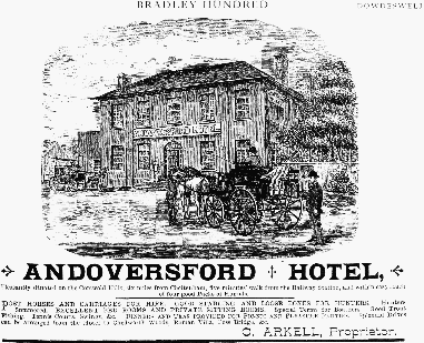
Fig. 3. Andoversford Hotel advertisement, 1889
Within a few years of the opening of the new Cheltenham–London road in 1825 (fn. 146) a coaching inn called the Andoversford inn (later Hotel) was built on the east side of the road. It was a two-storeyed square building with a hipped roof and had on the north side a large yard with ranges of stables on three sides. (fn. 147) From 1840 until the mid 1870s the innkeepers farmed Home farm at Andoversford, leasing both inn and farm from the Sandywell Park estate. (fn. 148) In the late 19th century they relied for part of their custom on the accommodation of hunting visitors and their horses. The hotel was also a stopping place for carriers from Cotswold villages to Cheltenham. The opening of the railway stations brought more business and in 1889 it kept its own post horses and carriages. (fn. 149) It closed c. 1980 and was later demolished to make way for housing.
A house called Crarricks House in 1737 (fn. 150) (later usually Carricks (fn. 151) or Garricks House) stood west of Andoversford on the north-west corner of the junction of the Gloucester road and the road from Lower Dowdeswell. Its position suggests that it was at one time an inn or alehouse, and in 1824 (fn. 152) and until the early 20th century a smithy adjoining served traffic on the main road. (fn. 153) A small stone house built at the south-west corner of the junction (within Withington parish) after 1819 (fn. 154) had opened as a public house by 1851 under the sign of the Garricks Head, (fn. 155) though the name Garricks House was also used sometimes for it as well as for the older house opposite. (fn. 156) The public house closed in the mid 20th century. (fn. 157) The small settlement at the road junction was enlarged in 1939 by an estate of eight council houses called Clock House Square (fn. 158) and in the 1950s and 1960s by a few private houses and bungalows, one replacing the original Garricks House. (fn. 159)
At Kilkenny, at the fork of the Gloucester roads to Stow and London, an inn called the Cross Hands opened shortly before 1780; it stood on the north side of the junction but its site was just within Withington parish. The innkeeper in the 1780s, Richard Stallard, also occupied adjoining land, for which he paid his rent to the owner of the Dowdeswell manor estate, Edward Rogers, partly in the form of postchaise hire. (fn. 160) The inn retained its sign of the Cross Hands until the mid 20th century, (fn. 161) but later it was called the Kilkenny inn. (fn. 162) The low, late 18th-century range of buildings also incorporated two cottage dwellings and a further dwelling was added to the range in the late 20th century.
At Cold Comfort, the high point on the Gloucester road west of Kilkenny, a house was built shortly before 1649. It was apparently intended only as a farmhouse for that part of the Upper Dowdeswell estate (fn. 163) but it had become the Cold Comfort inn by 1667 (fn. 164) and was open as such until 1777 or later. (fn. 165) The building remained a farmhouse on the Upper Dowdeswell estate (fn. 166) until the early 20th century, but it was derelict by the late 1960s when it was restored as a private house. It was later a restaurant and in 1994 became a small hotel under the name of the Pegglesworth Hotel. (fn. 167) The house (fn. 168) mentioned in 1649 was a two-storeyed, lobbyentry building with a three-bayed east facade with mullioned windows. In the early 18th century a south wing with a basement kitchen was added, giving the house an L plan, and in the 19th century a narrow range with a cellar was added in the angle. Early in the 19th century a canted bay was added at the north end of the original range facing the road. A farm building added on the west side of the house in the 19th century was taken into the house at the restoration in the 1960s and later given an additional storey.
In 1802 a friendly society called the Hand in Hand met at the Cross Hands at Kilkenny. (fn. 169) Another met at the Andoversford inn (later Hotel) in 1828 and was dissolved c. 1870, (fn. 170) and the Andoversford Working Men's friendly society met at the hotel from 1885 until its dissolution in 1909. (fn. 171) In 1900 Agatha Lawrence, sister of the owner of Sandywell Park, opened a reading room and working men's club at Andoversford for use by railwaymen. (fn. 172) In 1950 a village hall, formed of two wartime army huts brought from Sandywell park, was built for Andoversford on the east side of the Crossfield housing estate. It was opened in 1951 and managed in conjunction with an adjoining playing field, apparently laid out a few years earlier. Andoversford then had cricket and football clubs, which amalgamated into a single sports club c. 1964, (fn. 173) and the hall, enlarged and improved, served as village hall and sports clubhouse in 1998. A village hall for Upper Dowdeswell, a converted farm building on the south side of the lane there, was opened in 1927 (fn. 174) and remained in use in 1998.
A skirmish occurred at Andoversford in 1643 when royalist soldiers, some from Sudeley castle, attacked a detachment from Gloucester under Edward Massey, returning from a sally against Stow-on-the-Wold. (fn. 175) George Turner of Dowdeswell, whose family leased Upper Dowdeswell Manor farm, wrote a short survey of Gloucestershire agriculture for the Board of Agriculture in 1794. (fn. 176)
For most of the early modern period Dowdeswell, unusually for a place of its size, had several resident gentry families, occupying houses at Lower Dowdeswell, Upper Dowdeswell, and Sandywell Park, and litigation between them over manorial and parochial matters was a feature of the period. The Rogers family was at one time represented in the parish as landowners by four separate branches, one branch taking the name Coxwell-Rogers in the 19th century. (fn. 177)
Manors and Other Estates.
A mid 8th-century abbot called Headda inherited an estate at Dowdeswell, and in 759 a.d. he also acquired 10 cassati of land at 'Onnanforda' (apparently Andoversford) by gift of three princes of the Hwicce acting with the sanction of King Offa. Headda left his whole estate to any of his kinsmen who were in priestly orders, with reversion to the see of Worcester. (fn. 178) It prob- ably passed to the see before 957, when land at Pegglesworth was held from Bishop Coenwald. (fn. 179) A perambulation of the bishop of Worcester's Withington manor c. 1000 a.d. included the whole or most of Dowdeswell, (fn. 180) and in 1086 4½ hides in Dowdeswell and Pegglesworth (later accounted as 3 and 1½ hides respectively) were held from Withington by Robert. (fn. 181) By 1166 Dowdeswell and Pegglesworth were held as 1 knight's fee by Humphrey de Bohun, whose widow Margaret held them later in the 12th century. By Margaret's death c. 1197 the de Bohuns had made a subinfeudation to the Knights Templar, and a tenant-in-demesne held the bulk of Dowdeswell from the Templars, the Templars from the de Bohuns, and the de Bohuns from the bishops of Worcester. (fn. 182) In 1226 Humphrey de Bohun, earl of Hereford, was disputing the bishop's claim to service (fn. 183) and in 1299 the estate was said to render no service to the bishop. (fn. 184) The earl confirmed his ancestors' gift to the Templars in 1225 and 1244, (fn. 185) and later tenants-in-demesne held from Temple Guiting manor, the site of a Templar preceptory. (fn. 186) Corpus Christi college, Oxford, owner of Guiting from 1517, received a chief rent from the lords of Dowdeswell manor until the 19th century. (fn. 187)
In the later 12th century a man called Robert held Dowdeswell and Pegglesworth in demesne under the Knights Templar, (fn. 188) and William of Dowdeswell, who gave a demesne estate at Andoversford to the Templars before 1185, (fn. 189) was presumably another owner at that period. In 1248 Roger son of William was claiming half the manor of DOWDESWELL from John of Dowdeswell and also the lordship of four tenant holdings there. (fn. 190) A later owner was Robert of Dowdeswell, whose son William of Dowdeswell was lord of the manor in 1285 (fn. 191) and conceded dower to Robert's widow Agnes and her husband Thomas de Teye in 1287. William died before 1320 when, subject to rights in dower of his widow Maud, his son Thomas of Dowdeswell held the manor; Thomas retained the manor until 1328 or later. (fn. 192) John of Dowdeswell held it in 1346, (fn. 193) Richard Chastilon in 1358, (fn. 194) and William Gernon in 1400. (fn. 195) The same or another William Gernon was lord in 1434, (fn. 196) and in 1445 Dowdeswell manor was held by another William Gernon, a minor who had livery before 1451. (fn. 197) The last-mentioned William died in 1461, leaving his son and heir William, then a minor; (fn. 198) he died before 1479 when his son, also called William Gernon, was a minor in the custody of Edward Woodville. Four feoffees held the manor during the same minority in 1484. (fn. 199) In 1494 it was held by Elizabeth Hill, widow of Sir Thomas Hill; (fn. 200) she died in 1501 and was succeeded by her son Robert Hill, (fn. 201) a merchant of the Calais staple. Robert sold the manor in 1504 to Ralph Latham, a London goldsmith, (fn. 202) who sold it in 1505 to Edmund Tame of Fairford. (fn. 203) Edmund (d. 1534) was succeeded by his son Sir Edmund Tame, (fn. 204) who in 1539 leased the manor for 60 years to Joan Rogers, her son William Rogers, and members of William's family. (fn. 205)
At Sir Edmund Tame's death in 1544 a lifeinterest in the freehold passed to his widow Catherine (fn. 206) and by agreement among his sisters and heirs the reversion passed to one of the sisters Isabel, who married, apparently as her second husband, (fn. 207) William ap Rees. William, Isabel, and her son Rees ap Owen sold the reversion in 1558 to the lessee William Rogers, who died the same year; some rights reserved in that sale were released to his son William Rogers by Rees ap Owen in 1559. (fn. 208) Catherine Tame, who married Sir Walter Buckler and later Roger Lygon, (fn. 209) died in 1582 when the freehold was assumed by William Rogers. The Rogerses, a branch of a family based at Bryanston (Dors.), remained the principal landowners in Dowdeswell parish for over three centuries. (fn. 210)
William Rogers died in 1593, having settled the manor house and part of the estate on the marriage of his daughter Dorothy and John Higford and the rest on his own second marriage, by which he left an infant son William. (fn. 211) In 1594 the manor court was held in the names of John and Dorothy but in 1610 and 1611 in that of William, who was in the guardianship of Walter Savage and later of William Moulton. William came of age c. 1614 (fn. 212) and died in 1640, having settled the manor for life on his wife Philip (d. 1644), with reversion to his eldest son Don Rogers. Don's brother William (fn. 213) succeeded and in 1655 for the benefit of his creditors conveyed the estate to trustees, (fn. 214) who sold off parts during the 1660s. William (d. 1678) was succeeded by his son William Rogers, who came of age in 1683 with the estate still encumbered by debt and in 1687, in order to secure a release from the surviving trustee, sold a large part to John Vannam, vicar of Bibury. (fn. 215) William incurred further debts, and in 1695, to keep it 'in the name and family of . . . Rogers', he conveyed Dowdeswell manor to his kinsman and creditor William Rogers in return for an annuity. (fn. 216)
The new owner William Rogers, a London lawyer and Chancery Master, was from a younger branch of the family which had settled at Upper House in Dowdeswell. He died in 1734 (fn. 217) and was succeeded by his nephew John Rogers, rector of Dowdeswell, who in 1751 bought back the land alienated to Vannam in 1687. (fn. 218) The Revd. John Rogers (d. 1768) left the manor to his nephew William Rogers (d. 1783), who left it to his brother Edward. Edward (d. 1810) left it to his niece Hester Rogers with contingent remainders in favour of the sons of her sister Ann, wife of the Revd. Charles Coxwell, and a proviso that male heirs who inherited should take the additional surname of Rogers. (fn. 219) Hester, whose estate in Dowdeswell covered 806 a. in 1838, (fn. 220) died in 1848 and was succeeded by her nephew Richard Rogers Coxwell, who became R. R. Coxwell-Rogers. (fn. 221) He added Upper Dowdeswell to the estate in 1867 (fn. 222) and died in 1895. He was succeeded by his daughters Ellen, wife of Lt.-Col. George Beale-Browne, and Grace; Richard's eldest surviving son Godfrey, having been declared a bankrupt, had conveyed his reversionary life-interest to his mother Ellen (d. 1894) and she had left it to the two daughters. (fn. 223) Godfrey died in 1913, and in 1914 the manorial rights and the bulk of the estate belonged to his son Richard Hugh Coxwell-Rogers, (fn. 224) who was killed in action in 1915, having devised the Dowdeswell estate to a friend Cecil Mein Probyn-Dighton, who took the name Coxwell-Rogers. (fn. 225)
Several parts of the estate were later sold off, but most of the land in the Chelt valley was eventually re-united by purchases made by Cheltenham corporation to safeguard the catchment area of its Dowdeswell reservoir. In 1928 the corporation bought Dowdeswell wood and Woodlands farm, a total of 311 a. adjoining the reservoir on the north side of the valley, (fn. 226) and the following year it bought Home and Castle Barn farms (583 a.) from C. M. CoxwellRogers. (fn. 227) The corporation's Dowdeswell estate passed with its water undertaking in 1965 to the North West Gloucestershire water board and in 1974 to Severn-Trent Water, which sold some of the land in the 1980s, retaining in 1998 Dowdeswell wood and Castle Barn farm. (fn. 228)
The old manor site of Dowdeswell, on the west side of the church, was called the Farm in the early modern period and Dowdeswell Farm in the 19th century; in the late 20th century the two houses which stand close together there were known as Home Farm and Eight Gabled House. Following the purchase of Dowdeswell manor by a younger branch of the Rogers family in 1695 Upper House (later Dowdeswell Court), standing further south, was the residence of the owners, while the old manor buildings remained the centre of the principal farm on the estate. (fn. 229)
At Home Farm the older, western range was probably built by the Rogerses in the later 16th century, before 1581. (fn. 230) It is of two storeys, built of coursed squared rubble, and contains a twobayed hall with a chimneypiece with a fourcentred head; the western end retains part of the service end, originally divided from the hall by a timber-framed partition. The rest of the service end was probably removed in the 19th century (the apparent date of the present west wall). The chamber end on the east was rebuilt as a tall block of two storeys and attics in the 17th century, (fn. 231) apparently before 1638, (fn. 232) and has large windows in the gabled attics and a newel stair with timber treads and post at its southeast corner. In the 19th century the entrance in the hall range was moved to the centre of the north side and the cross passage was converted to a kitchen; the early 16th-century first-floor window with arched lights may have been introduced then. About 1971, during an extensive restoration of Home Farm and its adjoining buildings, (fn. 233) the entrance to the hall range was moved back to its old position.
Eight Gabled House, standing only a few yards to the south of Home Farm, is unusual both in its form and its position. Its original purpose is obscure. Its position and the lack of documentary reference to it as a separate house suggest it was always part of the same property as Home Farm. The assessment of William Rogers on 10 hearths in 1672 is likely to have covered both buildings, (fn. 234) and Eight Gabled House was certainly part of the same tenancy in 1838, when it was apparently no longer in domestic use. (fn. 235) It was used as a farm building to Home Farm in the mid 20th century until the restoration of the buildings in the early 1970s, when it was sold off as a separate dwelling. (fn. 236) Eight Gabled House contains (in the roof above the central corridor in the north part of the house) the remains of a substantial cruck and other re-used, smoke-blackened timbers. It is possible, therefore, that it originated in a medieval hall house that predated Home Farm. Its present form, probably assumed by 1687, (fn. 237) is a square building of two storeys and attics with three bays on the north and east sides and two bays on the south and west. Each face is surmounted by two matching gables (giving the house its name), the two- or three-light mullioned windows have individual hoodmoulds, and there are small, arched lights in the gables; a central north entrance is linked in a symmetrical composition to flanking windows by a single stringcourse. The east–west spine wall, containing two chimney stacks, is of large blocks of dressed stone, as was a wall that formerly divided the ground floor of the south part of the house into two unequal, unheated rooms. The south-west room formerly had a small, partitioned compartment at its south-west corner and possibly two other timber-framed subdivisions. North of the spine wall the house is divided into two rooms and a central corridor by substantial timber-framed walls; the west wall is close-studded on the ground floor but boxframed on the first floor and the box-framed east wall is of one build. The north-west room has beside the stack the base of a spiral stair, later hollowed to make a cauldron. The staircase, which has splat balusters, may have been imported into the central passage from elsewhere and re-erected in one straight flight. (fn. 238)
The former farmyard north of Home Farm includes on its north side a rubble-built barn of the late 16th century or the 17th. It is of five bays with a gabled cart-entrance to the south and retains its original roof of raised cruck trusses, which have arched braces to a tiebeam, a high collar, and a saddle carrying the ridge piece. (fn. 239) The barn has been extended, probably in the 18th century. To its west, forming the entrance to the farmyard, is a 16th-century stone-built gatehouse with a partly weather-boarded timber-framed upper storey containing a dovecot. During the restoration of the buildings in the early 1970s a range of cowsheds on the east side of the yard was remodelled to form a separate dwelling house and the barn and gatehouse were restored as part of the same property.
Upper House, so called by the 1670s, was evidently the dwelling with 6 hearths for which Richard Rogers of Dowdeswell was assessed in 1672. (fn. 240) The earliest visual evidence found, of the 1820s, (fn. 241) shows an H-plan, two-storeyed house of the late 16th century or the 17th; the main range had a south front with a symmetrical five-bayed centre, flanked by gabled wings and extended eastwards by other irregular ranges. Alterations seem to have been made in the 18th century or the early 19th, including the creation of a railed forecourt with a two-storeyed building attached at the south-west corner and the refenestration of the central bays of the house. An octagonal gazebo containing a cold bath was built on the slope to the west in 1773 (fn. 242) and survived in 1998.
In 1833 Hester Rogers pulled the house down and began to build a large new mansion, which was completed in 1837 and became known as Dowdeswell Court. It was designed by Charles Paul, of the firm of Rowland Paul & Sons of Cheltenham, though some details of the elevations were altered by the builder, a local mason Thomas Denley of Syreford, in Whittington. Hester Rogers ceased to employ Denley in 1835 as a result of a dispute over his charges, and the remaining work, mostly internal joinery, was completed by Joseph Rainger of Cheltenham. The house, built mainly of stone from Syreford quarry, is in a convincing early 18th-century style, the windows being copied from the nearby Sandywell Park, and it has stone carving of high quality, including the massive Corinthian capitals, which were carved by Denley. (fn. 243) The entrance front on the south has a five-bayed centre with two-bayed projecting wings and a hexastyle portico, the garden front on the west is of six bays, and a service wing projects to the east. The house was originally three-storeyed (fn. 244) but c. 1928 the top floor was removed, the parapet and the capitals of the angle pilasters being carefully reinstated. (fn. 245) The north front appears also to have been altered, for a mid 19th-century illustration shows its east five bays as projecting. Richard Coxwell-Rogers when he inherited the estate in 1848 remodelled the entrance hall to the designs of Samuel Onley of Cheltenham; a screen of columns has been partly blocked. (fn. 246) The groin-vaulted cellars beneath the balustraded terrace, south-west of the house, were probably built as part of the substructure of the new mansion, and there is a substantial coach house and stable block to the south-east.
It appears that Dowdeswell Court was not occupied by the Coxwell-Rogers family after 1897. It was tenanted by 1906, (fn. 247) and it was later sold, but it returned to the same ownership as the bulk of the estate in 1947 when Cheltenham corporation bought it. (fn. 248) Requisitioned by the Air Ministry during the Second World War, Dowdeswell Court housed in succession colleges for R.A.F. apprentices and for R.A.F. chaplains, the chaplains' college remaining there (fn. 249) until 1962; various other institutions occupied it later, including the staff college of Rolls Royce Ltd. and a special school for children with behavioural difficulties. The owners, Severn-Trent Water, sold the house c. 1985 to a consortium which opened it as a private nursing home for the elderly; that concern was succeeded by another nursing home called Cheltenham Dalecare, the occupant in 1998. The landscaped park adjoining the house was sold separately in the 1980s, together with the coach house which was converted to a residence. (fn. 250)
By the 15th century a large freehold estate was based on UPPER DOWDESWELL. It was then and later styled a manor, but in the late 16th century it owed suit to Dowdeswell manor, (fn. 251) whose owners resisted the claims to manorial rights of Edward Rich in the 1660s and 1670s and Edward Gilbert Rich in the 1730s. (fn. 252)
Upper Dowdeswell was evidently the manor at Dowdeswell that Richard Beauchamp, perhaps the heir of Lord Beauchamp of Powicke, sold to John Carpenter, bishop of Worcester, in 1463 or 1464. The bishop's purchase was presumably part of his scheme for the re-endowment of the college of Westbury-onTrym, (fn. 253) which held Upper Dowdeswell at the Dissolution. (fn. 254) In 1544 the Crown granted it with the other property of Westbury college to Sir Ralph Sadler (fn. 255) who sold it in 1549 to Richard Abington. (fn. 256) Richard died in 1593 and his son Edmund in 1605, (fn. 257) but Edmund's son Anthony had possession of the whole or part of the estate by 1588 (fn. 258) and had a conveyance from his father in 1589. (fn. 259) Anthony (d. 1631) was succeeded by his son John Abington, (fn. 260) who in 1649, when under sequestration for royalist activities, (fn. 261) sold the estate to Edward Rich, a lawyer. Edward died in 1681 and the estate was possibly retained by his widow Martha (d. 1684). Edward's grandson Lionel Rich (fn. 262) held it in 1687 and at his death in 1736 was succeeded by his grandson Edward Gilbert Rich (d. 1753), who devised the estate in trust for his daughter Mary. She married Robert Lawrence of Shurdington, but under a provision of her father's will Upper Dowdeswell passed at her death in 1761 to her cousin Thomas Rich, who sold it in 1774 to Charles Van Notten, a London merchant. (fn. 263)
Charles Van Notten, who assumed the surname Pole (that of his wife's family) in 1787 and was created a baronet in 1791, died in 1813. He devised Upper Dowdeswell to his fourth son, the Revd. Henry Pole, who from 1853 used the surname Van Notten Pole. The Revd. Henry (d. 1865) was succeeded by his son Henry, (fn. 264) who sold the estate in 1867 to Richard CoxwellRogers, owner of Dowdeswell manor. It then included c. 420 a. in the parish, comprising farms based on Upper Dowdeswell Manor, Ossage, Cold Comfort, and Woodlands. (fn. 265) In 1919 the owner of the Dowdeswell manor estate sold the various farms off separately. (fn. 266) Upper Dowdeswell Manor and a few fields were bought then by Capt. Ferdinand Reiss, (fn. 267) and during the mid 20th century the house was owned successively by the Clutterbuck and Bridgeman families. About 1980 it was divided into three dwellings. (fn. 268)
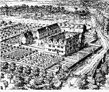
Fig. 4. Upper Dowdeswell Manor from the north-east, c. 1710
A chief house on the Abingtons' estate, presumably Upper Dowdeswell Manor, was mentioned in 1588, (fn. 269) and in 1672 Edward Rich was assessed for tax on 13 hearths. (fn. 270) When illustrated by Kip c. 1710 (fn. 271) Upper Dowdeswell Manor had four ranges of equal size enclosing a small inner court, the main fronts being to the north and the east; there was a courtyard of service buildings, including a large dovecot, on the west and south. The walled gardens, evidently laid out in the late 17th century, included massive north gatepiers and at the north-east corner a small gazebo, features which survived in 1998. In the late 18th or early 19th century, when the house was leased as a farmhouse, (fn. 272) the south range and the south part of the west range were demolished, making the house L plan. (fn. 273) The surviving north and east ranges were probably built in the late 16th century as hall range and chamber wing respectively; on the ground floor of both are chimneypieces with four-centred arches. The north range had three central bays, containing a ground-floor hall, and projecting, gabled wings with six-light mullioned and transomed windows. The north entrance doorway into the hall, surmounted by the Rich family's arms, is of the late 17th century; the entrance may have been moved to that position at that time and a doorway made in the east front for access to the garden. A well-staircase was built adjacent to the doorway. Some chimneypieces and bolectionmoulded panelling may also be of that date. Between 1919 and 1921 Capt. Reiss (fn. 274) replaced the west wing in a matching style and added a one-bayed wing, projecting east, to the south end of the east wing. His architects were Healing and Overbury of Cheltenham. (fn. 275) Since the early 18th century the north front has been altered by the addition of a porch and the removal of its central gable and the east front by replacing its doorway with a window and by the removal of its three gables.
PEGGLESWORTH formed part of Dowdeswell manor in the early Middle Ages, (fn. 276) and what appears to have been the principal freehold there in the late 16th century owed suit to the manor. (fn. 277) In 1619, however, that estate was said to be held directly from the former Templar manor of Guiting (fn. 278) and at times during the 17th century Pegglesworth was claimed as a separate manor. (fn. 279)
In the late 16th century Pegglesworth was divided among various owners, including the Rogerses of Dowdeswell manor, who had two yardlands there, and Giles Brydges, Lord Chandos, who had a house and 54 a. at his death in 1594, (fn. 280) possibly the lands at Dowdeswell in which his ancestor Giles Brydges of Coberley acquired an interest in 1501. (fn. 281) In 1605 one of Brydges's coheirs, Elizabeth wife of Sir John Kennedy, sold his Pegglesworth land to William Dutton of Sherborne (fn. 282) (d. 1618). William's son John (fn. 283) bought 2 yardlands at Pegglesworth from the Okey family in 1619, and in 1628 his estate there comprised a chief house and c. 200 a. John Dutton sold his estate in 1648 to Theophilus Brereton and Thomas Spencer, who in 1668 divided it between them, Spencer's land later passing to a Mr. Harris. Brereton added 1 yardland, bought from William Rogers, lord of Dowdeswell manor, in 1661, and in 1683 he sold his share to Thomas Ridler, a Stroud clothier. Ridler also bought out Harris and the other owners at Pegglesworth and took a lease of the rector's glebe land there, inclosing the whole into a compact estate. (fn. 284)
Thomas Ridler and his son Robert, who may have succeeded to part of his Pegglesworth estate, died before 1711; Thomas's three daughters Sarah, Hannah, and Mary, who soon afterwards married respectively William Jones, John Wade, and Richard Cambridge, then agreed to partition his estates. Sarah's share included the chief house and lands described as a moiety of Pegglesworth manor, while a reversionary right to other lands there, held in dower by Thomas's widow Winifred, was divided between the three of them. John and Hannah Wade (both d. by 1746) were succeeded by their son John Wade, (fn. 285) who inherited his aunt Mary Cambridge's share at her death in 1761. He died in 1793, leaving his estate to a kinswoman, Anna, the wife of William Gordon and later of John Berkeley Burland. (fn. 286) At Anna's death in 1819 (fn. 287) her share of Pegglesworth, said to be 7/10 of the whole, (fn. 288) passed to her son Robert Gordon of Kemble (Wilts., later Glos.). William and Sarah Jones's share of Pegglesworth passed to their daughters Elizabeth and Mary. Mary was a lunatic by 1774 in the custody of her cousin John Wade, who probably acquired her share. Elizabeth (d. 1752) left an unrestricted right in her share to her husband Samuel Storke (d. 1753), whose son and heir Richard died a minor in 1767, when under Samuel's will that share passed for life to his second wife Mary. Mary, who was married twice more, to George Hayley and Patrick Jeffery, died in 1808, when her share reverted to Samuel's heirs, Thomas Cooper and his sister Elizabeth Storke Cooper; Elizabeth died c. 1818, leaving her right to be sold for the benefit of her nephews and nieces. (fn. 289)
In 1821 Robert Gordon and Thomas Cooper (acting for himself and his sister's beneficiaries) were negotiating to sell the Pegglesworth estate, then comprising a farmhouse (later called Pegglesworth Home Farm) and 560 a., to John Gardner, a Cheltenham brewer. (fn. 290) By 1823, however, it was owned by James Fielder Croome of Cirencester, its former tenant. (fn. 291) Croome added the estate to lands he had bought in the adjoining part of Withington parish (later forming Pegglesworth Hill farm) (fn. 292) and died before 1838. (fn. 293) By 1867 the Pegglesworth estate belonged to William Hall (fn. 294) (d. 1872) and it passed, with his estate in Coberley to his daughter Sarah, (fn. 295) who married first John Hampson (d. 1876) and second, in 1884, Henry Bubb. Sarah Bubb conveyed Pegglesworth in 1885 to her first husband's sister, Mrs. Sarah Bouth, who sold it in 1894 to Charles Macintosh Rodger. The estate, based on Pegglesworth Home and Pegglesworth Hill farms, was enlarged by Rodger to a total of 1,034 a. by his purchase the same year of Needlehole farm, in Withington, and the former part of Ayles wood in Dowdeswell. He died in 1902 and his executors sold the estate in 1910 to George Forrest (d. 1914), who was succeeded by his brother Charles (d. 1915). (fn. 296) In 1922 the estate was bought by Andrew Hart, (fn. 297) who with his wife Catherine sold Pegglesworth Hill farm in 1924. (fn. 298) The Harts offered Pegglesworth Home farm for sale in 1932, by which time part of it, adjoining the Gloucester–Oxford road and including Pegglesworth House, was in separate ownership. (fn. 299) Pegglesworth Home farm belonged in 1977 to Robert Pilkington, who sold it then to Mr. A. Ebeid, who later bought back the land based on Pegglesworth House. Mr. Ebeid remained the owner of Pegglesworth in 1999, using some fields to pasture his polo ponies and leasing the rest to a farmer. (fn. 300)
Pegglesworth Home Farm dates from the mid or late 17th century and is an L-plan, rubblebuilt house of two storeys and attics. The symmetrical main front, to the north, has three gables, two- and three-light, chamferedmullioned windows, and a central entrance, linked by stringcourses stopped at each end of the facade. (fn. 301) A hall and parlour filled the ground floor of the main range, with service accommodation in the rear wing. The re-arranged wellstaircase has dumb-bell balusters. In 1970, to the designs of Kershaw & Ganter, (fn. 302) a tall porch, incorporating bathrooms, was added and the house was linked by a new range to a twostoreyed, 17th-century former cottage and outbuilding standing to the west. (fn. 303) Both 17thcentury buildings retain their original roofs, that over the main block having cambered collars. The ranges of 19th- and early 20th-century farm buildings, forming a yard on the north side, were adapted for stables and domestic purposes in the late 20th century.
The estate at Dowdeswell later called SANDYWELL was represented by a house and 2½ yardlands in the late 16th century. It was then a free tenancy, owing suit to Dowdeswell manor, (fn. 304) but c. 1600 and later it owed a quit rent and suit of court to Corpus Christi college's Temple Guiting manor. (fn. 305) William Lygon (d. c. 1577) was succeeded in one third of the estate by his son Richard, (fn. 306) and the remaining two thirds apparently belonged to Thomas Wye at his death in 1581, passing to his widow Gillian who married John Throckmorton. (fn. 307) Robert Rogers, probably a younger son of William Rogers (d. 1558), was tenant of all or part of the estate in 1581, (fn. 308) and c. 1588 he acquired the freehold, part from Richard Lygon and part from John Throckmorton. (fn. 309) At his death in 1628 Robert was succeeded by his son William (fn. 310) (d. 1664), whose widow Elizabeth retained Sandywell until her death in 1670. It then passed to William's daughter Elizabeth, (fn. 311) the wife of Paul Dodwell (d. 1691). Elizabeth, who had been married earlier to Sir Walter Raleigh (fn. 312) and continued to be styled Lady Raleigh, died in 1697. She had settled Sandywell on the marriage of her daughter Philip Raleigh to Oliver Weekes (fn. 313) (d. 1688 or 1689), and their son Carew Weekes sold it in 1704 to Henry Brett. (fn. 314)
Henry Brett sold Sandywell in 1712 to Francis Seymour-Conway, Lord Conway, (fn. 315) who added to it the adjoining Whittington estate in 1714. Lord Conway was succeeded at his death in 1732 by his son Francis, (fn. 316) who sold the estates in 1748 to Thomas Tracy, (fn. 317) M.P. for Gloucestershire. Tracy died in 1770 and his estates were retained by his widow Mary (fn. 318) until her death in 1799. Mary Tracy died intestate and litigation over her estate lasted until 1807. Three sisters Rebecca Lightbourne, Patience Timbrell, and Judith Timbrell were then declared heirs to the bulk of it and in 1809 had a conveyance from Mary's surviving trustees, Charles Hanbury Tracy and his wife Henrietta; other claimants were compensated with land at Upper Slaughter or with cash, and Rebecca's estranged husband, Thomas Lightbourne, surrendered his rights in return for an annuity. (fn. 319) Judith died in 1812 and Patience in 1814, both devising their shares to Rebecca, (fn. 320) who died in 1823, leaving her estate to Walter Lawrence Lawrence (formerly Morris). Attempts to upset Rebecca's will made by other claimants, partly on the grounds of undue influence by Walter's father, William Morris, who had managed her affairs, failed. (fn. 321) In 1838 Walter Lawrence's estate in Dowdeswell parish comprised 328 a., including Sandywell house and park and, at Andoversford, Home farm and the Andoversford inn. (fn. 322)
In 1847 W. L. Lawrence leased Sandywell house and park to Dr. Samuel Hitch, (fn. 323) who opened a private asylum there, initially in partnership with Dr. William Bush. (fn. 324) In 1851 it housed 17 patients and 23 servants and staff, including Hitch, his wife and daughter, and his son-in-law, the architect Frederick Waller, who managed the business side of the asylum. (fn. 325) In 1862 there were 30 patients. About 1865 Hitch, in debt for reasons unconnected with the asylum, sold the establishment to Dr. William Sankey, (fn. 326) who continued it until 1881 or later. (fn. 327)
Ownership of Sandywell and the rest of the estate remained with Walter Lawrence, whose financial difficulties led to the appointment of a receiver for his creditors in 1860. (fn. 328) He died in 1877 and Sandywell was presumably retained, as was Whittington, (fn. 329) by his widow Mary before passing to his son Christian William Lawrence, who took over Sandywell as a residence again before 1889. C. W. Lawrence, who followed a career in the diplomatic service, (fn. 330) died in 1920, (fn. 331) and the same year his coheir, his niece Katharine Evans-Lawrence, sold Sandywell house and its park to Hubert Stephens of Gloucester. (fn. 332) Sandywell was bought in 1925 by Capt. Thomas Colville (d. by 1950), and it was later acquired by the English, Scottish, and Australian Bank, which leased it in 1962 to Gloucestershire county council. The council used it as a conference centre for adult education and youth courses (fn. 333) until the mid 1970s, and from c. 1976 until 1980 it was owned by Mr. A. Preston, who restored it and used part as a showroom for an antiques business. In the early 1980s the house was converted to form 12 flats. (fn. 334)
Robert Rogers had a house at Sandywell on or close to the site of the present mansion c. 1600, (fn. 335) and in 1672, when occupied by Paul Dodwell, it had 10 hearths. (fn. 336) A new house was built by Henry Brett soon after 1704 and was illustrated by Kip c. 1710. (fn. 337) Its main front faced west. The plan was double-pile, with a transverse corridor running between a central entrance on the south front and the services, which included a low projecting wing, on the north side. Flanking wings were added on the north and south for Lord Conway, probably in the 1720s. The new wings, of two by five bays and three storeys with balustraded parapets and baroque detail, were possibly designed by Francis Smith of Warwick. (fn. 338) The west facade of the original house seems to have been slightly altered: pedimented dormers replaced circular ones in the outer bays and a doorcase with semicircular pediment replaced a mannered one. (fn. 339) Early eighteenth-century panelling has survived throughout, with mannered pedimented doorcases on the east wall of the present entrance hall and in the upper part of the staircase hall, but internal alterations seem to have been made for Lord Conway. The staircase seems to have been replaced or remodelled and the lower part of the staircase hall altered and given more conventional classical detail. The west entrance hall may have been created at the same time, possibly partitioned from a central saloon. The south wing appears to have accommodated the new saloon.
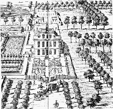
Fig. 5. Sandywell Park from the west, c. 1710
Alterations to Sandywell Park were made by Walter Lawrence in 1824 (fn. 340) and by Samuel Hitch in 1847. (fn. 341) The ground floor of the north wing and the south-west room of Brett's original house were redecorated and plain two-storeyed wings were added on the south-east and northeast; some sashes and the staircase window appear to have also been altered. By the 1850s the cupola and balustrade of Brett's house had been replaced, (fn. 342) the latter with an iron railing, and in 1861 (fn. 343) a ballroom was fitted up in the north-east wing. When the house was divided into flats in the 1980s much panelling was reproduced in matching early 18th-century style.
The formal approach to Henry Brett's new house was from the Kilkenny–Whittington road on the west by an avenue leading through the deer park, described above, (fn. 344) but the entrance forecourt lay on the south side, the west front having a railed parterre. The stable court was to the east and the formal gardens lay on the north. (fn. 345) During the Conways' ownership wrought-iron gates, with the family crest incorporated in the overthrow, were set in the west wall of the park, at the end of the avenue, and a gateway with urn-surmounted pillars and a similar overthrow in the south wall. The drive approach seems to have been from Whittington by 1770. (fn. 346) When he enlarged the park northwards to the new Cheltenham–London road in 1824 Walter Lawrence made an entrance with a pair of lodges on the new road to the north-west of the house, (fn. 347) but that was later abandoned in favour of one on the same road north of the house, where there is another set of 18th-century pillars and gates, perhaps moved from an old entrance on that side, and another lodge. A small dovecot and clock tower, dated 1851 with the initials of Samuel Hitch, stands north of the stable block.
The Knights Templar, who had a mesne lordship over the whole of Dowdeswell in the 12th and 13th centuries, themselves acquired an estate there and annexed it to their manor of Temple Guiting. (fn. 348) The core of the estate was the part of the parish adjoining Andoversford: 'Temple Andoversford' was named among the hamlets of Guiting manor in 1328, (fn. 349) and c. 1600 the extreme eastern end of the parish formed a separate liberty of TEMPLE DOWDESWELL, which owed suit to the Guiting manor court. (fn. 350) It was claimed, however, that the liberty should actually extend as far west as the road called the salt way, running between Kilkenny and Whittington, (fn. 351) and land at Upper Dowdeswell and Pegglesworth seems also to have once been Templar property.
The land at Andoversford was given to the Templars by William of Dowdeswell before 1185, when their tenant Jordan (evidently known as Jordan of the Temple) held demesne land and 2½ yardlands and another tenant held 1 yardland. (fn. 352) One of the earls of Hereford, the Templars' overlords in Dowdeswell during the 13th century, was also said to have given them a house and land in the parish. (fn. 353) At least one large freehold was later based in the Andoversford end of the parish, possibly representing Jordan's estate: in 1367 Ralph of Andoversford had 3 yardlands with other lands in Dowdeswell, Andoversford, and adjoining parishes; (fn. 354) in 1388 Thomas Adynet of Northleach had an estate described as in Temple Dowdeswell and Pegglesworth; (fn. 355) and shortly before 1599 2½ yardlands within Temple Dowdeswell liberty and a messuage at Upper Dowdeswell were sold by John Redfern to Henry Browne. (fn. 356) Corpus Christi college, Oxford, owner of Temple Guiting, retained a few closes at the end of the 16th century but ownership within the liberty was by then much divided, with the college, Browne, and the owners of the Sandywell, Upper Dowdeswell, and Shipton Solers estates all having land within it. Also presumably old Templar property, but lying outside the liberty as then defined, were a tenement at Upper Dowdeswell and 1 yardland 'in the fields of Dowdeswell', belonging to Corpus Christi, and lands called Temple fields and Temple meadow, belonging to the Upper Dowdeswell estate. (fn. 357) The college still owned the site of a cottage and barn at Upper Dowdeswell in 1830, and its yardland was presumably represented by three fields lying south of Sandywell park which the park's owners held by copyhold under the college in the 18th century and the early 19th. (fn. 358)
About 1200 Richard de Croupes granted the Templars pasture rights in his manor of Whittington for livestock kept at the 'court' of Jordan of the Temple. (fn. 359) That was probably the place called the Temple or Old Temple beside Temple Lane at the south-east corner of (the later) Sandywell park: there were ruined buildings there c. 1600, (fn. 360) and the remains of a rectangular moat, fed from a spring that rises near by, with traces of building foundations at its centre were visible in 1998.
Lands in ROSSLEY, which formed a detached part of Withington parish, were given to Studley priory (Warws.) before 1330 by Peter of Ashridge and Jordan, his brother, (fn. 361) and in 1462 the owners of Dowdeswell manor held a house and land (later recorded as 50 a.) there from Studley. (fn. 362) In 1536 another estate at Rossley, described as a pasture with woodland belonging to it, was owned by Winchcombe abbey, which leased it to Richard Rogers and his family. (fn. 363) The Crown granted the abbey's estate in 1547 to John Dudley, earl of Warwick, who sold it shortly afterwards to Owen Whorwood. (fn. 364) Whorwood sold it in 1550 to William Rogers, Richard's son. (fn. 365) William was then lessee of the other part of Rossley, of which his family became owners, with Dowdeswell manor, in 1582. (fn. 366) Rossley, usually styled a manor, then descended with Dowdeswell manor until the early 20th century and, together with lands lying within Dowdeswell parish, formed one of the main farms of the estate. (fn. 367) Before 1923 C. M. Coxwell-Rogers made the house at Rossley his residence (fn. 368) and he kept it, with 73 a. of land, when he sold the rest of his Dowdeswell estate in the late 1920s. (fn. 369) About 1930 he opened a residential country club called Rossley Manor, much enlarging the house and providing it with squash and tennis courts and a swimming pool. At his death in 1953 he left it to Mr. (later Lt.Col.) R. A. Coxwell-Rogers (a descendant of the former owners of Dowdeswell) who continued it as a country club until 1966. He sold Rossley Manor in 1993 to Mr. J. Hitchins. (fn. 370)
In 1883 the buildings at Rossley comprised a farmhouse with a south entrance, and an attached barn which extended northwards to link with other farm buildings ranged around a yard. Other outbuildings stood to the southwest and south-east (fn. 371) but those were removed during extensive remodelling in the first half of the 20th century, which transformed the farmhouse and its attached buildings into a large, rambling residence in the revived Cotswold style.
The original house, surviving as part of the south range in 1999, was built in the mid 16th century in large blocks of dressed stone and was probably of a single storey with attics. It appears to have had four bays with two ground-floor rooms and a through-passage, represented by the doorway on the south front. There is a heavy beam with broach-stops near the west end of the range and an original chimney stack on the west wall. In the mid or late 17th century a twostoreyed wing, with an attic and one room on each floor, was added to the north-east, forming an L plan; a 16th-century, four-centred headed doorway with vase-stops has been reset in its north wall. Probably some time later, and with workmanship of a very poor quality, the adjoining part of the main, south range was raised and roofed in line with the wing. In the 18th century a brick-built addition of two storeys and attics was made to the east end of the south range and by 1883 the whole east side of the house had been extended to the east. (fn. 372) The farm buildings appear to have been added mainly in the 19th century.
The remodelling of the farmhouse (fn. 373) as Rossley Manor had begun by 1914, when the east side had become the new entrance front and had a 17th-century style, gabled facade and the east front of the former barn had been given mullioned windows. On the west side of the house a lean-to had been replaced by a loggia and a single-storeyed addition had been built. By 1929 the south range of the farm buildings around the yard had been replaced by a singlestoreyed range of bedrooms and garages and the east range had been reconstructed as other accommodation; brick was used for the walls facing into the courtyard. Further alterations followed for the country club during the 1930s, additional bedrooms being planned in 1933 and 1935. (fn. 374) The south range of the courtyard was raised to two storeys and the east front of the house was remodelled by the addition of three projecting wings, and the south front was given a two-storeyed gabled projection, which partly masked the brick-built east bay. All the facades were given mullioned windows and so looked consistently 17th-century in style. After 1945 the west range of the courtyard was replaced by a two-storeyed cottage, and a long, projecting two-storeyed range containing bedrooms was built south of it. A pair of detached cotttages was built to the north-east of the house in the mid 1940s. (fn. 375) A single-range, timber-framed house, brought from its original site on the north side of Cheltenham (by Gloucester Road), was re-erected at the entrance to the drive of Rossley Manor on the London road in 1929. (fn. 376)
Economic History.
Little is known of the early agricultural organization of Dowdeswell, partly because ownership of the land was fragmented. Dowdeswell manor apparently had demesne arable enough to employ two ploughteams c. 1300, when its lord William of Dowdeswell granted a house and 16 a. to a smith to hold by the service of providing the fittings for two ploughs and shoeing his warhorse. (fn. 377) The manor had at least four customary tenants in 1248, (fn. 378) and in 1558 there were five tenants holding from it by copy. (fn. 379) In 1599 four copyhold tenements were granted to members of the Higford family, relations of the lord and lady of the manor; the purpose of the grants is not clear but they may have been a preliminary to enfranchisement, as three of the estates were later freeholds. They were 2 yardlands based on the house later called Upper House (fn. 380) then in the tenure of Richard Rogers (d. 1609), a younger brother of the former owner of the manor William Rogers; (fn. 381) 3 yardlands which became Lower House farm, long in the possession of another branch of the Rogerses; (fn. 382) and 6 yardlands held by William Okey (or Smith) which were based on a farmhouse at Upper Dowdeswell and remained in part in possession of the Okeys until the late 18th century. (fn. 383) The fourth tenement recorded in 1599, 1 yardland in the tenure of Henry Hibbert, remained a copyhold of the manor in the tenure of the Hibberts and their successors until the mid 18th century. (fn. 384)
The Upper Dowdeswell estate had tenants paying a rental of 20s. in 1535 when they were called customary tenants, (fn. 385) but in later disputes over the alleged manorial status of Upper Dowdeswell no evidence that it ever had copyhold tenants owing suit to a manor court was produced. (fn. 386) Some land of the former estate of the Knights Templars at Dowdeswell remained copyhold under Temple Guiting manor until the 19th century. (fn. 387)
There is evidence for Dowdeswell's share in Cotswold sheep farming from the end of the 12th century when the Templars' estate there was given rights to pasture a flock of 300 in the adjoining manor of Whittington. (fn. 388) A shepherd was among those assessed for tax at Dowdeswell in 1381. (fn. 389) In the mid 1460s, following his purchase of the Upper Dowdeswell estate, John Carpenter, bishop of Worcester, built a sheephouse, cleared pastures, and stocked the land with sheep. (fn. 390) The sheephouse and pastures were possibly on what became the Woodlands farm of the estate, where there was a field described as the old sheephouse close in 1632. (fn. 391) Another sheephouse in the parish, belonging to Lower House farm, was mentioned in 1664. (fn. 392)
Dowdeswell, excluding the Pegglesworth area, was inclosed in 1562 by an agreement between the lessee of the manor William Rogers, the copyhold tenants, and the freeholders including Richard Abington of Upper Dowdeswell. (fn. 393) The details of the inclosure are not known, but it appears to have replaced at least two open fields, an upper field occupying land between Upper Dowdeswell and the main Gloucester road and a lower field (possibly also called Temple field) extending from the Kilkenny–Whittington road eastwards towards Andoversford. (fn. 394) The inclosure possibly covered common downland in the high part of the parish, where a sheep down of 100 a. on the south side of the Gloucester road, called Dowdeswell (or Cold Comfort) hill, belonged in severalty to the Upper Dowdeswell estate in 1649 (fn. 395) and one of 166 a. on the north side of that road, called the Downs and Castles (after the prehistoric camp), belonged to the Dowdeswell manor estate in 1687. (fn. 396) In the 17th century, and presumably from the origins of the parish as a part of Withington, all or most of the Dowdeswell freeholders and the rector had land in Foxcote common meadow, both within and outside an area of the meadow that formed a detached part of Dowdeswell parish. (fn. 397)
Following the inclosure Dowdeswell was farmed as a mixture of substantial tenant farms and smaller freeholds. The latter, having been formed by enfranchisement, apparently in 1599, were eventually re-absorbed into the Dowdeswell manor estate, the Upper House estate in 1695 when its owner bought the manor, (fn. 398) the Okeys' farm based at Upper Dowdeswell in 1769, (fn. 399) and Lower House farm in 1858. (fn. 400) During the 18th and 19th centuries the Dowdeswell manor estate comprised two main tenant farms. Dowdeswell farm, based on the old manor house (Home Farm), had 182 a. in 1782, (fn. 401) while a farm based on the farmhouse at Rossley and including buildings at Castle barn had 349 a. in 1786. (fn. 402) Those two farms remained much the same size in the 19th century, Dowdeswell farm having 176 a. in 1879 and Rossley farm 321 a. in 1872. (fn. 403)
On the Upper Dowdeswell estate new farmhouses were built before 1649 at Ossage, near Andoversford, and at Cold Comfort, on the high sheep down beside the Gloucester road. About 80 a. forming the detached part of the estate between Dowdeswell wood and the Whittington boundary, was provided before 1687 with a small farmhouse, (fn. 404) later called Woodlands. In 1774 the estate comprised four units, based on Upper Dowdeswell Manor, Ossage, Cold Comfort, and Woodlands, but all were then leased to the same farmer. (fn. 405) Later, Woodlands with 84 a. was a separate tenancy, but the other three parts of the estate, a total of 354 a. employing 10 farm labourers in 1851, continued as a single farm, (fn. 406) worked from c. 1820 to c. 1910 by members of the Arkell family. (fn. 407)
Of the agricultural land at Andoversford belonging to the Sandywell Park estate 86 a. was farmed in 1838 from Home Farm, on the west side of the Cheltenham turnpike road, and 37 a. from the Andoversford inn, on the other side of the road; (fn. 408) all that land was presumably included in the 170 a. that the innkeeper was farming in 1851. (fn. 409)
Pegglesworth had its separate open-field system comprising a north field on the high plateau above and to the west of Pegglesworth Home Farm and a south field south-east of the farmhouse extending to Ratshill bank. (fn. 410) In 1661 a yardland in the Pegglesworth fields was 48 a. and had pasture rights for 12 beasts and 120 sheep. (fn. 411) By the early 1680s when Thomas Ridler began purchasing land in Pegglesworth the whole or part of the north field had been inclosed to form a sheep walk; having acquired all the land, Ridler completed the inclosure of Pegglesworth and turned more of the arable land to sheep pasture. (fn. 412) The large ring-fenced farm that resulted was said to be almost entirely arable c. 1785, (fn. 413) but over 100 a. of its highest land, west of the farmhouse, was still cultivated as sheep pastures (slaights) in 1838. (fn. 414) In 1851, when it included land in the adjoining part of Withington, it was a Cotswold sheep- and cornraising farm of 690 a., employing 18 labourers. (fn. 415)
The lower parts of the parish, with much steep land, considerable woodland, and tracts of parkland attached to the principal houses, were less intensively cultivated. Even in the mid 19th century, in the parish as a whole, pasture and meadow was rougly equal to arable: in 1838 880 a. was pasture and 884 a. arable, (fn. 416) and in 1866 778 a. was returned as permanent grassland and 897 a. as under crops or rotated grassland. (fn. 417) In the late 19th century and early 20th the balance shifted firmly to permanent grass, which was returned as 1,493 a. compared with 467 a. under crops in 1926. (fn. 418) Cattle farming played an increasing role over that period, with cattle (raised mainly for beef) returned at 86 in 1866, 230 in 1896, and 250 in 1926. Sheep and lambs were returned at 864 in 1866 and 1,803 in 1926. (fn. 419) In 1926 a total of 19 farms was returned in the parish, most of modest size for the Cotswolds: only one was over 300 a. and only three others over 100 a. They then employed a total of 27 full-time workers. (fn. 420)
By 1956 the proportions of arable and permanent pasture, then supporting one or more dairy herds, were roughly equal again, and in 1986 for Dowdeswell civil parish (the Andoversford end of the ancient parish having been removed) 281.5 ha. (696 a.) of arable and 152.8 ha. (378 a.) of grassland was returned. Fifteen farms, employing 25 workers, made returns in 1956. (fn. 421) During the late 20th century some land and most of the farmhouses went out of agricultural use, and in 1986 for the civil parish only three farms, worked by 11 people, made returns; one was an arable enterprise, growing mainly winter barley and wheat, one was a dairy farm, and the third was worked part-time. (fn. 422) In 1998 the farms based in the ancient parish of Dowdeswell were Castle Barn, Woodlands, and Heylyns Farm (near Upper Dowdeswell), and some land, including most of Pegglesworth, was occupied by farmers from outside the parish.
Dowdeswell mill, situated on the river Chelt at the west boundary of the parish, (fn. 423) was recorded from the late 16th century. There were two mills there in 1591, one new-built. (fn. 424) In 1620 the lord of Dowdeswell manor William Rogers granted a lease of the two mills for six years to the owners of Upper Dowdeswell, Sandywell, and Upper House. (fn. 425) There were evidently still two mills at the site in 1649 when the lower mill was mentioned. (fn. 426) Dowdeswell mill was included in the lands that were alienated from the manor estate to John Vannam in 1687 (fn. 427) and returned to the estate in 1751. (fn. 428) It apparently remained in use until Dowdeswell reservoir was built on the Chelt just above it, (fn. 429) its site being absorbed in the waterworks below the reservoir dam.
In 1381 the inhabitants of the parish included 3 tailors and a carpenter. (fn. 430) The only tradesmen listed at Dowdeswell in the muster roll of 1608 were a miller, a millwright, and a glover. (fn. 431) In 1831 six families in the parish were supported by trade and 27 by agriculture. (fn. 432) During the 19th and 20th centuries most trading activity was concentrated at Andoversford. In 1851, however, a stonemason had a yard at Hill Cottages, just above Lower Dowdeswell, and employed 9 workmen, (fn. 433) and the cottagers at Upper Dowdeswell included a grocer in 1856 (fn. 434) and a shopkeeper and a carpenter in 1906. (fn. 435) During the 19th century there was a smithy at Garricks Head on the Gloucester road; (fn. 436) that small roadside settlement also had a carpenter in 1828 and in 1851, when he kept the beerhouse there, and a mason in 1831. (fn. 437) At the Kilkenny inn, on the same road further west, the landlord was a haulier in 1856. (fn. 438)
By the early 18th century the woodland of the Dowdeswell manor estate supplied wood in many small consignments, presumably for domestic fuel, to inhabitants of Cotswold villages as far away as Bibury and the Slaughters, (fn. 439) and in the 1790s that trade was bringing the owner an income of around £250–£350 a year. (fn. 440) In the 1920s and 1930s stone quarries were worked commercially on the high ground by the Gloucester road near Kilkenny. (fn. 441)
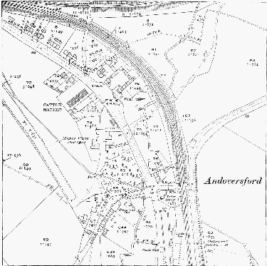
Fig. 6. Andoversford in 1920, with the Midland and S.W. Junction railway on the north-east of the hamlet and the Banbury and Cheltenham on the north
A mason was living at Andoversford in 1807. (fn. 442) By 1838, as the hamlet developed under the influence of the new turnpike road of 1825, a smithy stood at the crossroads formed by that road and the Gloucester-Stow road and a carpenter's shop close by, and the hamlet also had a butcher. (fn. 443) In the 1830s and 1840s its inhabitants included chaise drivers and ostlers employed by the Andoversford inn or the nearby Frogmill inn, (fn. 444) and in 1841 three Andoversford men were described as horsekeepers. (fn. 445) In 1864 Walter Lawrence of Sandywell Park established a brick and tile works at the north end of the hamlet, in the angle between the Cheltenham road and the Banbury and Cheltenham railway line, then under construction. (fn. 446) He let the works to the railway company in 1876. (fn. 447) Production apparently ended c. 1890 when the Midland and South Western Junction railway was built across the site. (fn. 448)
Shortly before 1894 the railways prompted the opening of a livestock market, holding fortnightly sales, on a site opposite the Andoversford Hotel. (fn. 449) It was established by farmers from the surrounding area of the Cotswolds, who formed a limited company called the Andoversford Sale Yard Co. (fn. 450) By 1906 two coal merchants (one also dealing in hay) and a corn and manure merchant had premises at Andoversford, (fn. 451) and during the earlier years of the 20th century it was a depot for railway freight, with, as well as the livestock on market days, much corn and timber being loaded there and large quantities of coal unloaded for distribution to surrounding villages. (fn. 452) In 1939 elements of what had become an important centre for the area were the saleyard, coal merchants, two public houses, two garages, a doctor's surgery, a branch of the National Farmers Union, a post office (kept at Home Farm), the smithy, and a grocer, builder, and newsagent. (fn. 453) The livestock market remained open in 1998, dealing mainly in sheep brought from farms within a distance of 25–30 miles; the sales, then held once a week with special sales in autumn, were conducted by the firm of Tayler & Fletcher, auctioneers of Stow-on-the-Wold, who leased the market from the shareholders. (fn. 454)
A small industrial estate was established on the south side of Andoversford in 1966 by Mr. V. A. Masek, who moved his furniture-making firm, Balanced Bobbins, to the site of former sidings of the M. & S.W.J. railway. (fn. 455) Other firms settling there later included Cleanacres, makers of agricultural sprays, and Cotswold Windows, making window units. In the late 1980s a development company bought another part of the former railway property further south and introduced other businesses. (fn. 456)
Local Government.
In 1299 the bishop of Worcester claimed jurisdiction over Dowdeswell, as over other former members of Withington, for his view of frankpledge held at Withington; but Dowdeswell evidently freed itself early from that jurisdiction, sending no representatives to the Withington court in the late 15th century or afterwards. (fn. 457) In addition, in 1287, the Knights Templar claimed view of frankpledge in Dowdeswell, Upper Dowdeswell, Pegglesworth, and Temple Andoversford, saying that their tenants from those hamlets attended their view at Temple Guiting. (fn. 458) Whether that was a general claim over the whole parish made in respect of the Templars' mesne lordship under the de Bohuns or in respect of specific tenements that they had obtained in fee is not clear, but c. 1600 the owners of Guiting, Corpus Christi college, Oxford, claimed leet jurisdiction, waifs, strays, and other unspecified rights in a 'liberty' called Temple Dowdeswell, restricted in area to the Andoversford end of the parish. (fn. 459) In spite of those ancient claims, in the late 16th century and the 17th the lords of Dowdeswell manor held their own court leet and baron which appears to have exercised jurisdiction over the whole of the parish, with the owners of the Upper Dowdeswell estate and owners from Sandywell, Pegglesworth, and Temple Dowdeswell all owing suit as free tenants. (fn. 460)
A later complication was that in the 1670s Edward Rich, seeking to establish that his Upper Dowdeswell estate was a separate manor, held his own court baron and summoned his tenants to attend. He also attempted to intimidate William Okey, whose freehold farm based on Upper Dowdeswell was a former copyhold of Dowdeswell manor, into rendering suit. When his claim to hold the court was challenged by William Rogers, lord of Dowdeswell manor, Rich seems to have been unable to produce any concrete evidence or precedent, (fn. 461) and no record has been found of his successors holding a court.
A court book, recording courts held for Dowdeswell manor during the period 1577–1673, (fn. 462) was compiled from original court records in the late 17th century, and the proceedings of the 26 courts it contains are probably not a complete record of those held in the period. (fn. 463) The court leet heard presentments of assaults and bloodshed intil 1649 or later, (fn. 464) and in 1588 and 1610 the lords exercised a claim to take felons' goods. (fn. 465) In 1730 the lord claimed a horse as a deodand after a man was killed in a road accident on Cold Comfort hill. (fn. 466) Since suit was owed to it from, apparently, the whole parish, the court involved itself in matters of parochial government in the 16th and 17th centuries. It elected the two surveyors of the highways for the parish, enforced the performance of statutory road work, and in 1663 fixed a rate for those who wished to compound for their obligations in that respect. (fn. 467) In 1634 the jury complained that the inhabitants of Pegglesworth were refusing to do their share of the road work. (fn. 468) The court also made efforts to keep down the poor rates, demanding that parishioners give security for lodgers they took in and report any beggars to the constable and, in 1664, ordering the constable to take action against vagabonds. (fn. 469) The office of constable was served by a rota of the householders of the parish. (fn. 470)
The surviving records of parish government include churchwardens' accounts for the years 1683–1731, 1741–78, and 1815–1909, (fn. 471) overseers' accounts for 1687–1782, (fn. 472) and vestry minutes for 1840–65. (fn. 473) The parish offices were sometimes served by the resident gentry of the parish: the lord of the manor William Rogers was a churchwarden in 1661 (fn. 474) and Paul Dodwell and Lionel Rich were among the overseers in the 1680s. (fn. 475) The appointment of the officers and the passing of their acounts were left in the hands of two or three leading parishioners; in the 1740s, for example, John Rogers, rector and lord of the manor, Edward Gilbert Rich of Upper Dowdeswell, and William Rogers of Lower House were sometimes the only ones present on such occasions.
In the late 1770s the overseers of the poor deputed a man, presumably salaried, to carry out their duties. No more than two or three paupers were ever on permanent relief during the late 17th and early 18th centuries, rising to c. 5 in the mid 18th century. (fn. 476) Late in the century one or two paupers were housed by the overseers in cottages rented from the lord of the manor at Lower Dowdeswell. (fn. 477) Between 1813 and 1815 14–16 people were on regular relief each year (fn. 478) but the annual cost of relief, and presumably the numbers relieved, had fallen significantly by the last years of the old poor-law system. (fn. 479)
Dowdeswell became part of the Northleach union in 1836 (fn. 480) and was later in the Northleach rural district (fn. 481) before becoming part of the new Cotswold district in 1974.
Church.
Dowdeswell church, on architectural evidence, was founded during the Norman period. It originated as a chapel to Withington at a time when Dowdeswell formed a part of that large manor. It evidently had its own separate endowment by 1287 when a rector of Dowdeswell was mentioned, (fn. 482) and in 1413 the rector was said to have performed the full sacraments in the church time out of mind. Until 1413, however, when Dowdeswell was given burial rights, the parishioners still carried their dead to Withington for burial and paid mortuaries to its rector. (fn. 483) The rectors of Dowdeswell later owed an annual pension of £2 to the rector of Withington (fn. 484) and until the late 15th century their church was sometimes styled a chapel or 'chapel with cure of souls' (capella curata). (fn. 485) Dowdeswell remained part of the peculiar of Withington, whose rector exercised archidiaconal powers, (fn. 486) including the induction of the incumbents, (fn. 487) and proved the wills of Dowdeswell parishioners in his court. (fn. 488) Dowdeswell was made a united benefice with the Shiptons and Salperton in 1975, when the ecclesiastical parish was renamed Dowdeswell and Andoversford. (fn. 489)
In 1306 the advowson of the rectory was held by the lord of the manor, William of Dowdeswell, (fn. 490) and it remained in the possession of his successors. William Beaufiz presented during a minority in 1445. (fn. 491) In 1568 and at two later vacancies William Rogers, farmer of the manor under Lady Catherine Buckler (later Lygon), presented under her grant, (fn. 492) becoming patron in his own right when assuming the freehold of the manor in 1582. (fn. 493) The Queen presented during a minority in 1598, and in 1778 John Read of Frenchay, in Bristol, exercised the advowson for one turn. (fn. 494) The ladies of the manor Ellen Beale-Browne and Grace CoxwellRogers were patrons in 1910, (fn. 495) and in 1931 and 1939, when it had not been exercised since 1908, the advowson belonged to Sir C. A. King Harman. (fn. 496) About 1941 it was acquired by the Martyrs' Memorial Trust and c. 1952 by the Church Pastoral Aid Society. (fn. 497)
The rector of Dowdeswell received all the tithes of the parish. (fn. 498) By the early 17th century it was customary for the owners of the main estate in Pegglesworth to make a fixed payment of 26s. 8d. a year for tithes, except those of grain, but in the 1620s the rector William Driver took action against John Dutton to enforce payment in kind or a new composition. (fn. 499) In 1672 the rector Joseph Stone agreed to let the tithes of Theophilus Brereton's land at Pegglesworth, together with glebe land there, to Brereton for £5 a year. (fn. 500) The tithes of the Sandywell estate were leased by the rector John Rogers to the owner, Lord Conway, for £7 a year in 1718. (fn. 501) The tithes arising from a few fields at the east end of the parish were replaced by a rent charge of £3 16s. under the inclosure award for the Shiptons in 1793, (fn. 502) and the remainder were commuted for a corn rent charge of £421 4s. in 1838. (fn. 503)
In 1612 the rector's glebe comprised c. 24 a. in two closes in Lower Dowdeswell, 5 a. in Foxcote common meadow, and uninclosed arable in the Pegglesworth open fields. The Pegglesworth land was for long a cause of dispute. It was thought to be ½ yardland in 1612 but, being insufficiently distinguished from William Dutton's lands in the fields, it was in danger of being lost to the rectory. (fn. 504) When Joseph Stone became rector in 1670 he found the land, then said to be 1 yardland (48 a.), rented by the various owners in Pegglesworth for a total of £10 a year, and c. 1680 only 4 a. of it could be identified. When Thomas Ridler inclosed Pegglesworth in the early 1680s he did not accept that any of it was glebe land, claiming that payments made to the rectors by former owners had been for tithes only. He came to an agreement with the rector about the matter, but in 1713 his heirs were again denying that there was glebe there. Following litigation, (fn. 505) in 1715 the Ridlers accepted a lease from the rector John Rogers of all the glebe at Pegglesworth, together with all the small tithes there, at £15 a year. (fn. 506) In 1838, when no part of Pegglesworth was accounted as glebe, the rector had 22 a. in the parish, mostly in closes north of the rectory house. (fn. 507)
The rectory house was recorded with its farm buildings from 1612 and was described c. 1680 as comprising 5 bays and measuring 94 ft. in length. (fn. 508) It was sold after the union of the benefices in 1975, the incumbent residing at Shipton. (fn. 509) The building, which stands on the north side of Lower Dowdeswell village, may post-date that described c. 1680, having no front of the length or number of bays then specified. In its present form it is a two-storeyed, U-plan building of dressed limestone with a stone-slated roof. It has gabled wings on the south-west, where, because of the steep slope, there is a high basement; the north-east, entrance front is of seven asymmetrical bays under a roof with hipped ends. The south-east end is the earliest part of the house and seems to have had an L plan, with three-bayed north-east and southeast elevations; there are mullioned-andtransomed cross windows on the north-east front, a former central entrance on the southeast front, and the remains of an original staircase. The house was enlarged c. 1780 by the rector William Baker, (fn. 510) who was presumably responsible for replacing the windows on the south-east front with sashes and for moving the entrance to the north-east by adding a threebayed projection, which contains the entrance hall and has a Tuscan portico. Alterations made soon after 1826 by Charles Coxwell (fn. 511) apparently included the addition of a bay within the U of the south-west front and the addition or rebuilding of the north-west wing. A chimneypiece in the south-east wing may also be part of that work. By 1926 (fn. 512) a square bay window, since removed, had been attached to the west bay of the north-west front. Late 20th-century alterations and additions included the flat-roofed infill, with a conservatory above, between the wings on the south-west front.
The living of Dowdeswell was valued at £13 6s. 8d. in 1535, (fn. 513) £80 in 1650, (fn. 514) £100 in 1750, (fn. 515) and c. £160 in 1771. By 1803, however, the value had risen to c. £350. (fn. 516) The corn rent of £421 awarded for the tithes in 1838 had declined in value by 1889 when the living was worth £345 net. (fn. 517)
The rector John of Dowdeswell who died c. 1306 (fn. 518) and other men of the same name who were instituted in 1307 and 1326 respectively (fn. 519) were presumably relatives of the lords of the manor. William Somerset, a monk of Eynsham abbey (Oxon.), was dispensed to hold the living in 1445 (fn. 520) and was succeeded the following year by Richard Necton, a doctor of medicine. (fn. 521) In 1551 the rector John Strange was found satisfactory in knowledge of doctrine but employed a curate who was unable to repeat the Ten Commandments. (fn. 522) Christopher Andrews, rector 1554–67, also had the rectory of Canon Frome (Herefs.). He neglected Dowdeswell: the churchwardens complained in 1563 that no alms were given to the poor, no provision made for sermons, and that both church and churchyard were in disrepair. (fn. 523) Andrews was temporarily suspended for failure to appear at a visitation in 1566. (fn. 524) Thomas Child, rector 1575–98, (fn. 525) was not a graduate or preacher but in 1576 was judged to be a good Latinist and sound in theological knowledge. (fn. 526) In 1605 the rector Robert Temple, described as a usurer, and his curate John Harby, described as a drunkard and common gamester, were indicted for shortcomings in their ministry, and a public altercation between the two during a church service was reported. (fn. 527) William Driver was instituted in 1623 and survived the changes in Church policy until his death in 1670. (fn. 528)
In 1713 John Rogers (d. 1768) was presented to Dowdeswell by his uncle William Rogers, whom he later succeeded as lord of the manor. William Baker, rector from 1778 and from 1803 also vicar of Stonehouse, (fn. 529) was involved in a series of disputes over minor matters with the lord of the manor Edward Rogers, whom on one occasion he physically assaulted. (fn. 530) In 1821, when Baker had been absent for several months without providing anyone to serve the cure, the bishop licensed as curate Charles Coxwell, (fn. 531) brother-in-law of the lady of the manor. Coxwell, who inherited the Ablington estate at Bibury, (fn. 532) succeeded Baker as rector in 1826 and served to his death in 1854. His son William Rogers Coxwell-Rogers (who followed his elder brother, the lord of the manor, in adopting the additional surname) succeeded to the living and held it to 1894; he was succeeded in turn by his son Richard who served to 1908. (fn. 533)
In 1919 C. W. Lawrence of Sandywell Park gave a site at the north end of Andoversford for a building to be used for church services under the direction of the rector of Whittington. (fn. 534) The building remained in use as a mission hall until 1951 or later. (fn. 535)
The church of ST. MICHAEL, (fn. 536) which stands on the hillside at Lower Dowdeswell, is predominantly Perpendicular in style, a large part of it built in the 16th and early 17th centuries. Of dressed limestone, it is cruciform on plan, and comprises chancel with south organ chamber, central tower with spire, transeptal chapels, and nave with south porch and northwest vestry. Many of its interior fittings are reminders of the parish's leading landowners.
Fragments from a Norman church were found buried in the churchyard in the 19th century, including a tympanum with the 'Tree of Life' motif and some dogtooth ornament and part of a capital, which were later set in the south wall of the organ chamber built in 1867. (fn. 537) The base of the tower and the east end of the nave are of the 14th century, though the crude groin vault in the tower and the buttresses against its east and west sides may have been constructed when the spire was added in 1577. The chancel is mainly of the late 15th century and has a north window and an unceiled wagon roof of that period. The south porch was added in the 16th century, and the north transeptal chapel has 16th-century windows, probably preReformation. The short splay-footed, stoneslated spire was built in 1577 at the cost of nine leading parishioners, whose names are recorded in an inscription cut into the sill of the west window of the north chapel. (fn. 538) The south transeptal chapel was rebuilt in 1632. (fn. 539)
In 1840 the south wall of the chancel was rebuilt with new Perpendicular-style windows and a doorway, (fn. 540) but in 1867 at the cost of Richard Coxwell-Rogers an organ chamber was built (fn. 541) in the angle formed by that wall and the south chapel, and the doorway and one of the windows were re-set in the chamber. A new east window was inserted in the chancel in 1849 in memory of Hester Rogers, lady of the manor, and her sister Ann Coxwell, the rector's wife; (fn. 542) it forms part of a triptych, the side panels of which are inscribed with the Commandments, Creed, and Lord's Prayer. The nave and north transept also acquired new windows in the 19th century and a small vestry was added to the north-west of the nave.
The south transeptal chapel of Dowdeswell church was apparently the lady chapel in the Middle Ages, (fn. 543) but according to John Abington in 1632 it was used after the Reformation as a private chapel by his family, owners of the Upper Dowdeswell estate. Anthony Abington, John's father, left a legacy for rebuilding it when he died in 1631, (fn. 544) but the rebuilding was carried out the following year as a joint project of the parishioners and only £10 of the total cost of £50 was supplied by the legacy. (fn. 545) Nevertheless, John Abington secured a licence from the bishop confirming an exclusive right in the rebuilt chapel for himself and later owners of his house. He was immediately challenged by the owners of Dowdeswell manor, Sandywell, and Lower House (all called William Rogers), who presented evidence that the original chapel had long been used by the parish in general. Arbitrators appointed in 1634 (fn. 546) seem to have decided in favour of Abington, for the chapel, called Abington's chapel, was included in later conveyances of the Upper Dowdeswell estate (fn. 547) and in 1804 was referred to by Edward Rogers, the lord of the manor, as Sir Charles Pole's aisle. (fn. 548) The north transeptal chapel was apparently common to the parish in 1632 when poorer parishioners sat there at service time, (fn. 549) but it appears to have been appropriated later to the lords of the manor: many of the Rogers family were buried there, (fn. 550) and in 1804, when part seated his female servants, Edward Rogers called it 'my aisle'. (fn. 551)
Much of the floor space in the small church came to be occupied by the proprietary seats of Dowdeswell's gentry families and seating for them and their households sometimes caused tension. It was said that in the mid 16th century all, including the lord of the manor and his visitors, were content to use stone benches or wooden 'plank' seats, (fn. 552) but c. 1590 Edmund Abington built himself a more substantial seat, and c. 1610 Robert Rogers of Sandywell built one in the south chapel. After the rebuilding of that chapel in 1632 William Rogers, lord of the manor, built two seats there for his household, aggravating the dispute over ownership. (fn. 553) A seat for the Sandywell estate was built in the body of the church by Henry Brett in the early 18th century and, after some objections by other parishioners, was confirmed to Thomas Tracy in 1752. (fn. 554) Later in the 18th century Tracy's widow ejected the parish clerk from a seat in the south chapel in favour of her female servants, and the chapel then contained a large pew of the Pole family, its owners. Edward Rogers owned more than seven seats in the church in 1804, when seating was among matters in dispute between him and the rector William Baker. (fn. 555) All or most of the proprietary seats were removed in 1837 and a matching set of pews, which survived in 1998, was installed. (fn. 556) A gallery built at the west end of the nave by Hester Rogers in 1822 (fn. 557) and a smaller one of similar type and date against the north wall of the north chapel survive; both were reached by external stairs.
The font, which has quatrefoil panels on the bowl, dates from the 15th century. Set in an 18th-century ledger stone in the centre of the chancel is a late-medieval brass of a priest in processional robes; (fn. 558) the inscription is lost and the grounds for identifying the priest as an abbot of Hailes, as was done c. 1710, are unknown. (fn. 559) The large number of wall monuments still in situ is a feature of the church, the great majority for members of the Rogers and Coxwell-Rogers families. On the north wall of the chancel is a large and ornate monument by Christopher Horsnaile the elder (fn. 560) incorporating a portrait bust to William Rogers (d. 1734), Chancery Master and lord of the manor. In the south chapel there are monuments to William Rogers (d. 1664) of Sandywell, his wife Elizabeth (d. 1670), Edward Rich (d. 1681), owner of Upper Dowdeswell, and Baily Rich (d. 1723), son of Lionel Rich. A hatchment for one of the Riches is fixed to the chapel's south wall, and there are others for members of the Rogers family above the galleries at the west end of the nave and in the north chapel. An early 19th-century royal arms (fn. 561) surmounts the chancel arch.
A chalice, paten cover, and plate were said c. 1700 to have been given to the church by Martha (d. 1684), widow of Edward Rich, (fn. 562) but of the set later in use only a plate of 1671, inscribed with the initials 'M R', apparently derived from the gift; a chalice of 1662 has an inscription recording its acquisition in 1664. There is also a tankard flagon, given in 1766 by John Rogers, rector and lord of the manor. (fn. 563) Edward Rogers (d. 1810) left the church a large silver christening bowl of a type known as a 'monteith', made in 1690 and an heirloom of his family. (fn. 564) It was used for christenings in the church until some time in the late 19th century when the bishop objected to the practice on liturgical grounds and ordered the font to be used. The christening bowl was later sold to one of the CoxwellRogerses for a sum of money assigned to church maintenance. (fn. 565) The three bells, which hang in a medieval frame, are a treble of the early 17th century, a second of the 15th century, and a tenor cast by Edward Neale in 1658. (fn. 566) The iron railings enclosing the churchyard, which have two sets of gates with the Rogers arms and motto, were given in 1828 by Ann Coxwell. (fn. 567) The parish registers survive from 1575. (fn. 568)
Nonconformity.
There were apparently no early dissenting meetings in Dowdeswell parish. (fn. 569) Wesleyan Methodists of the Cheltenham circuit who were established at Whittington and Shipton by the mid 1860s later held services at Andoversford, which, as a convenient central site for the district, became the focus of the meeting. (fn. 570) The Andoversford meeting was well established by 1874 when a single Primitive Methodist living in the hamlet was recommended by his quarterly meeting to join the Wesleyans. (fn. 571) In 1882 the Cheltenham circuit bought two cottages on the Gloucester road south-west of the Royal Oak inn and adapted one as a chapel, which opened for services in 1885. Then and until the early 20th century the meeting was led by William Harvey, a stationmaster at Andoversford. The chapel was refurnished and redecorated in 1957 using funds raised earlier in an abortive scheme to buy a site for a new chapel. (fn. 572) There were only a few members by 1993 when the chapel was run by a combined church council for Andoversford, Shipton, and Hawling, (fn. 573) and it closed before 1998 and was reconverted to a dwelling.
Education.
By 1818 Dowdeswell had a day school teaching 13 children, some at the cost of a lady of the parish; (fn. 574) she was probably the lady of the manor, Hester Rogers, or possibly Rebecca Lightbourne of Sandywell Park, who at her death in 1823 left an endowment for a Sunday school at Whittington. Rebecca Lightbourne's bequest was used in 1830 to set up a day school at Whittington, which some Dowdeswell children attended. (fn. 575) Dowdeswell parish had its own day and Sunday schools in 1833 supported by private contributions; the former taught 10 children. (fn. 576)
In 1843 a small, single-storeyed schoolroom was built at Upper Dowdeswell (fn. 577) at the joint expense of Hester Rogers and the rector Charles Coxwell. (fn. 578) In 1858 the lord of the manor Richard Coxwell-Rogers was meeting an annual deficit in the funding, most of which was supplied by other contributors and school pence. The school had an average attendance of 49 children in 1858, (fn. 579) and it was apparently by then affiliated to the National Society. In 1885 the average attendance, in one mixed class under a mistress, was 45, (fn. 580) and it had fallen to 31 by 1904, when the school was called Dowdeswell C. of E. school. (fn. 581) Average attendance increased to 53 by 1922, (fn. 582) but the school was closed in 1928 when a new school for the district opened at Andoversford. (fn. 583) The building at Upper Dowdeswell was a private house in 1998.
The school at Andoversford, called Dowdeswell Andoversford Council school, opened in 1928 at a site on the north side of the Gloucester road. Accommodation was provided for 160 children and in 1932 it had an average attendance of 113 children from the surrounding villages in mixed and infants' departments. (fn. 584) Later called Andoversford Primary school, it assumed grant-maintained status in 1993 and had 85 children on its roll in 1998. (fn. 585)
Charities for the Poor.
Robert Rogers (d. 1628) of Sandywell left £5 to the poor of Dowdeswell, (fn. 586) and another £5 was left by Anthony Abington (d. 1631) of Upper Dowdeswell. (fn. 587) The £10 from the two gifts was later put out at interest, but no record of the charities has been found after 1683. (fn. 588)
In 1793 following an assault on Edward Rogers, the lord of the manor, by William Baker, the rector, a court awarded the former £159 7s. 3d. in damages. In 1795 Rogers assigned the interest on that sum to provide gowns and shoes for poor women of the parish, designating the bequest the Martyrdom charity and stipulating that Baker and his successors should be excluded from any part in its management. Later he used it to provide gowns and small cash doles and it was continued in that form by his heir, Hester Rogers, (fn. 589) until 1830 or later. (fn. 590) The bequest apparently remained in existence as a private charity until 1941 when a member of the BealeBrowne family, a descendant of the Rogerses, was responsible for the principal sum, then invested in stock. In that year the bequest was regulated by a Scheme of the Charity Commission under which trustees were appointed and the proceeds applied to help poor women of the parish in clothes, boots, linen, fuel, or other necessities; (fn. 591) £4 a year was being distributed in 1970. (fn. 592)
Charles Rogers Coxwell (d. 1892), a son of the lord of the manor, (fn. 593) left £300, the income to be distributed at Christmas to the poor at the discretion of the rector of Dowdeswell. The charity's income was c. £7 from stock in 1970 when it was merged with the Edward Rogers charity under the style of the Coxwell and Rogers charity; the income was to be applied in cash or kind to the poor of Dowdeswell civil parish as constituted from 1956. (fn. 594)