A History of the County of Huntingdon: Volume 2. Originally published by Victoria County History, London, 1932.
This free content was digitised by double rekeying. All rights reserved.
'Parishes: Bluntisham cum Earith', in A History of the County of Huntingdon: Volume 2, (London, 1932) pp. 153-158. British History Online https://www.british-history.ac.uk/vch/hunts/vol2/pp153-158 [accessed 24 April 2024]
In this section
BLUNTISHAM CUM EARITH
Bluntesham (x to xiii cent.); Blondesham (xiv cent.); Bluntysham, Bluntsome, Blunsham (xvi cent.).
Herhythe, Herhethe (xii cent.); Herethe, Erehethe, Erhuth (xiv cent.); Earette, Earythe (xvi cent.).
The two townships of Bluntisham and Earith, which are a mile apart, have probably always formed one ecclesiastical parish. The parish contains 3,354 acres, of which 1,254 are arable, 1,262 permanent grass and 484 fruit orchards. Only 10 acres remain of woodland. (fn. 1) The soil varies; in the gravel area fruit trees, barley and oats do well, while on the loam and clay lands wheat prevails. The water supply is derived from gravel springs in places, but it is chiefly from wells that are fed by surface water, called 'sock' wells. On the west, near the Somersham road, is a chalybeate spring, where more than one attempt was made in the 18th century to establish a spa, called Somersham Spa. Its waters had a certain vogue, being recommended by Addenbrooke, Layard and others.
Evidence of Neolithic and Roman inhabitants have been found and have already been described. (fn. 2)
The four open fields of the old village can still be traced. Higham Field lay in the north-western part of the parish, about 100 ft. above sea level; Gull Field in the south-western part, gradually sloping down to the river Ouse, taking its name from the 'gulls' or water channels. From Higham Field eastward on the north side was Colneway Field; and between that and Bury Fen, which lies below the church, was Old Mill Field or Inhams, stretching from Bluntisham to Earith. North-west of Higham Field lay Barnfield Farm and until comparatively modern times on the declivity facing the south was a large wood which was probably that mentioned in the Domesday Survey. (fn. 3) It occurs in old records as the Hangar of Bluntisham and in 1341 it is given with Warboys as the boundary of the Bishop of Ely's right of hunting. (fn. 4) All that remains of this wood now is a group of trees called the Pingles, past which were the 'Cowgaps' whereby cows went from Bluntisham Fen on the south to the cow pastures on the slope. Speed's map of 1610 shows this wood as bigger than the famous Monks Wood. By the time of the inclosure it was divided into High Wood and Low Wood, the Pingles being then distinct by itself. Even in 1843 there were 68 acres of woodland left, but they have gradually disappeared leaving their names only. On the northern side of Barnfield lie two small spinneys, which were no doubt part of Somersham Forest. The western end of the parish was part of Somersham Heath, which was inclosed in 1797. There was no road across it before then. This part of the parish is still known as Bluntisham Heath.
The western end of the village of Bluntisham is called Wood End. Eastward is the Colne road, where are some of the oldest buildings, but the main part of the village runs straight north and south to the Rectory corner on the St. Ives road. At this point stood the village pound, and a small hamlet known as Little London. At the head of the High Street stands a barograph, erected as a memorial to some of the Tebbutt family. On it is recorded the height above sea level 60 ft., longitude 0° 0' 32" E., latitude 52° 21' 14". North of the Rectory stands a fine meeting-house of the Baptists, originally built in 1787 and rebuilt in 1875.
The Rectory is a large two-storied building with a square front, built of white brick, concealed by which are old attic gables. Its present form dates from 1848. In the middle of the front is an old doorway, now used as a window, which was brought from Cromwell's house in St. Ives, when it was pulled down in 1848. The Rectory stands in a garden of 3 acres. The parsonage house is named in terriers of the early 17th century, but Dr. Samuel Knight who died in 1746 built himself an 'excellent house, and laid out a great deal of money in gardens about it.' (fn. 5) A remarkable hurricane in 1741 untiled the roof of this rectory, and destroyed statues and balustrades. About 1800 the Rev. R. Tillard built a new rectory. The setting of the rectory among groups of fine trees and flower beds affords an attractive view to those who pass along the Ely road.
Earith means mud (or more probably gravel), hithe, a landing place. (fn. 6) It has always had an importance distinct from Bluntisham because of its propinquity to the river. The village lies chiefly along the road coming from Earith Bridge towards St. Ives, and extends for about half a mile. A few houses, including the British School, stand along the road turning northwards to Colne. Many Quakers had their home in Earith after 1650, and they still have a meeting-house in a retired spot at the western end which was originally built at Bluntisham in 1755. There is also a Wesleyan chapel and a Mission room which is used for church services and for Sunday school.
Earith Bridge has always been important. As early as 1346 the commonalty of the county complained to parliament that the bridge which had been used from ancient time was entirely gone for default of repair. A commission was therefore issued to William Moyne and others to inquire into the matter and to compel those who were liable to carry out the necessary repairs. (fn. 7) The bridge and causeway over Haddenham Fen, then known as 'Earith Causey,' were looked after by hermits in the 14th and 15th centuries. Indulgences were granted in 1397 for Richard de Grymston, a poor hermit, and in 1401 for Henry Bourne, for the repair of Earith Causeway. (fn. 8) There is a record also of the 'profession' of John Thomson, hermit of Earith Causeway. (fn. 9) In 1455 a carpenter was paid for repairing divers defects in the making of the roadway of the Great Bridge of Earith which indicates that the bridge was of timber. (fn. 10) The question of the liability to repair the Great Bridge and Earith Causeway was raised about 1638 when it was stated that the causeway and bridge were anciently maintained by the Bishops of Ely 'by right of sundry great manors belonging to the see.' During the long vacancy of the see, however, in Elizabeth's reign they were repaired by the crown, and later, when the bishop surrendered several of the manors of the see to the crown, the crown grantee became thereupon liable. About 1613, it is said, the High Bridge or Great Bridge over the Ouse fell down and was not rebuilt, but Earith Bridge seems to have been still in existence in 1637. (fn. 11) This bridge, called the Great Bridge, was over the West Water, which dried up after the Bedford Rivers were made, and it is difficult now to locate its exact position.
The bridge known as Seven Holes over the Old Bedford River, was erected in 1812, (fn. 12) and the cast-iron bridge over the New Bedford River was built in 1826, at the same time as the Hermitage sluice or 'sasse' was rebuilt. (fn. 13)
The Old Bedford River was declared finished in 1636, and the New Bedford River in 1653. (fn. 14) It would seem that a loop lying in the curve of the West Water was cut away from the parish by the new river, where lay the Hermitage and the chapel of St. Mary. Earith has always been interested in the navigation of the River Ouse. John Christine of Earith was due to deliver 60 tons of wheat at Lynne to a merchant of Bordeaux in 1425. (fn. 15) From Stuart times till the middle of the 19th century busy trade went on with barges or lighters conveying corn, wood, iron, salt, coal, stone, oilcake, etc. In order to improve navigation, about 1830 a staunch was made at the southern limit of the parish between Earith and Overcote, called Brownshill Staunch. The improvement of land transport, and especially the coming of railways, took from Earith many industries that depended on river carriage. The chief survivor of Earith industries at the present day is Messrs. Jewson's Wood Yard, the river serving chiefly as an attraction for devotees of the art of coarse fishing.
Bury Fen is a name well known in skating literature, and claims to be the home of 'bandy,' there being evidence of matches played early in the 19th century. (fn. 16) The railway from Ely, completed in 1878, now crosses it, and has spoilt its mile-long course, but it is still a popular resort, whenever a frost gives a chance of skating.
Earith Bulwarks have already been described. They probably date from the Civil Wars of the 17th century. There is mention of Parliamentary forces holding the 'Hermitage Pass' in 1643. (fn. 17) Camden has a passage stating that outlaws and rebellious barons 'built fortresses both at Earith and Aldreth.' (fn. 18)
MANORS
The history of the manor of BLUNTISHAM goes back to the early part of the 10th century, when it was seized by Toli the Dane, who is said to have been jarl or alderman of Huntingdon. Toli was killed at the Battle of Tempsford in 921, when the shire with Bluntisham returned to the rule of Edward the Elder. Later Bluntisham, probably by grant from the crown, became the property of Wulfnoth (Wlnoth) who about 970–75 sold it to Bishop Ethelwold and Brithnold, the first abbot of Ely, for the endowment of Ely Abbey. The sale was confirmed by King Edgar, after whose death in 975 a claim to it was made by the sons of Bogo de Hemingford, who said it was the inheritance of Tope their uncle. According to their story Tope's grandmother in her maidenhood went to the assistance of Edward the Elder against Toli, the Danish earl, and consequently Toli seized her lands, which, as his property, would be confiscated by the crown after the Battle of Tempsford. In the pleadings it is stated that throughout the sheriffwick (vicecomitatus) of Huntingdon there was no land which was not subject to forfeiture saving two hides in Bluntisham held by Ælfsicyld and two hides in Spaldwick. The claim by the sons of Bogo was declared false by the county court and the men of the six hundreds, numbering over a thousand, testified to the title of Wulfnoth. The sale to Ely Abbey was therefore confirmed. (fn. 19) In the Domesday Survey (1086) Bluntisham as the land of the Abbey of Ely was assessed at 6½ hides, and is the only manor of the soke of Somersham for which a priest and a church are returned. (fn. 20) When the bishopric of Ely was founded in 1108, a division of the lands of the abbey was made and Bishop Harvey allotted to the prior and convent certain payments of timber from Bluntisham and a 'mansura' of land with 5 acres from which the timber was collected and 8 acres of meadow upon which the oxen that drew the timber pastured. (fn. 21) This evidently represented Bluntisham manor which continued to be in the hands of the prior and convent of Ely until the Dissolution. (fn. 22) In 1541 the manor of Bluntisham formerly belonging to the prior and convent was granted to the newly formed dean and chapter of Ely. (fn. 23) On the abolition of deans and chapters in 1649 the manor was granted to Valentine Walton the regicide, as a reward for his services to Parliament. (fn. 24) At the Restoration it was restored to the dean and chapter and was owned by them until 1869, when it was taken over by the Ecclesiastical Commissioners, who are now lords of the manor.
Ely Priory. Or three keys azure.
HINTON'S MANOR
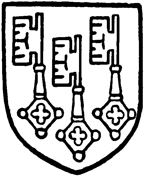
HINTON'S MANOR in Bluntisham may represent the two hides held by Ælfsicyld, which about 975 were not subject to forfeiture. (fn. 25) In 1272 Henry Aucher had a grant of free warren in his lands in Bluntisham, (fn. 26) and in 1276 Henry son of Aucher and Ella his wife granted lands in Bluntisham to Ralf de Hynton. (fn. 27) In 1279 Ralf de Hinton held of Henry 'Auger' and Ella his wife and they held of the Bishop of Ely a messuage and garden with demesne and other lands and a windmill in Bluntisham and Earith. Ralf held by the service of a quarter of a knight's fee and Henry and Ella by a rent of 3s. to the bishop, the payment of which rent had been transferred to Ralf. (fn. 28) What is termed the manor of Bluntisham with lands in Hinton (co. Camb.) was conveyed in 1307, probably for a settlement, by Stephen de Offynton to John de Hynton and Isabel his wife, (fn. 29) who in 1332 settled it on William their son. (fn. 30) William died without issue, leaving a widow Isabel, who entered upon the manor apparently as dower. Ralf, brother of William, sued her in 1350 and obtained possession. (fn. 31) Ralf de Hynton of 'Thetford next Ely,' and Sir John de Hynton, chivaler, his son, made a further settlement of the manor in 1366, (fn. 32) and in 1392 Sir William Castelacre and others, probably feoffees on behalf of Sir John de Hynton or his representatives, obtained licence to alienate the manor in mortmain to the prior and convent of Ely. (fn. 33) This manor probably became known as that of STOKKINGS in Bluntisham, which was held by the prior and convent of Ely in 1539, (fn. 34) when it was in lease to Thomas Dunholt. It was granted with the chief manor in 1541 to the dean and chapter of Ely, (fn. 35) and followed the descent of the chief manor (q.v.), the Ecclesiastical Commissioners being the present owners.
A manor called since the 17th century BARNFIELD MANOR or FARM, belonged to the dean and chapter of Ely and was sold by the Commissioners for the sale of Dean and Chapter Lands to Giles Calvert, a London stationer. It was returned to the dean and chapter at the Restoration. (fn. 36) A few claims were made under it at the time of the Inclosure Award, but the property being mostly leasehold was sold through the Ecclesiastical Commissioners after the Order in Council of 1870.
At the time of the Domesday Survey (1086) the Abbot of Ramsey had half a hide in Bluntisham, which was assessed to the geld. (fn. 37) This is probably the land in Bluntisham held by Guy de Auco, a tenant of Ramsey Abbey, early in the 12th century. It descended to his son Gilbert son of Guy, the sewer (dapifer), who was dealing with it in the time of Reynold, Abbot of Ramsey (1114–30). (fn. 38) Apparently it followed the descent of Stow Manor in Woodhurst (fn. 39) (q.v.) until the time of Simon, Bishop of Salisbury (1297–1315), when the Abbot of Ramsey regained possession, (fn. 40) and it probably became absorbed into another of the abbot's manors.
The manors of Colne and Colne Dunholt extended into Bluntisham, but their descents are given under Colne parish (q.v.).
The manor of EARITH was probably included in the early grants of Bluntisham; it is not mentioned in the Domesday Survey (1086). At the division of the estates between the Bishop of Ely and the prior and convent about 1108, Earith seems to have been retained by the bishop. The bishop was holding in 1279. (fn. 41) The principal profits from the manor were the fishery and the ferry, for which returns are made in the accounts of the bailiff and other officers of the bishop. In 1318 the bishop was granted a weekly market on Wednesdays, and a fair on the vigil, feast and morrow of St. James. (fn. 42) King James I confirmed this grant, and added two other fairs, on St. George's day and All Saints' day, 'to the tenants of Prince Charles in the vill of Earith.' (fn. 43) The manor of Earith became absorbed into the soke of Somersham (q.v.), with which it is now held.
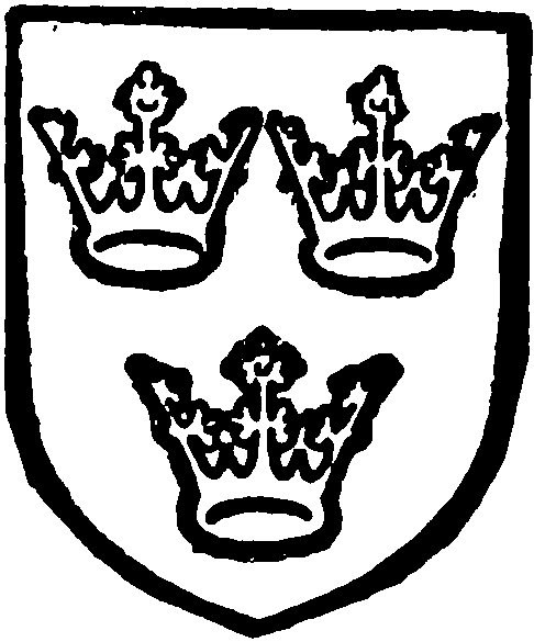
Bishopric of Ely. Gules three crowns or.
CHURCH
The Church of ST. MARY consists of a chancel (37 ft. by 18 ft.), north vestry (9½ ft. by 10½ ft.), nave (51½ ft. by 16½ ft.), north aisle (11¾ ft. wide), south aisle (11¾ ft. wide), west tower (13¼ ft. by 12 ft.), and north and south porches. The walls are of rubble with stone and clunch dressings, and the roofs covered with tiles and lead.
Of the church mentioned in the Inquisitio Eliensis and in the Domesday Survey (1086) nothing now remains, the earliest parts of the existing building being the chancel with its north vestry or chapel built about 1330, and the west tower built about 1370–1380.
About 1450 the nave and aisles were rebuilt, the aisles being extended to the west wall of the tower, the side walls of which were pierced with arches; and the chancel arch rebuilt. The south porch was built at the same time as the aisle, but the north porch was added slightly later, as is shown by the plinth of the aisle running through the porch wall. (fn. 44)
The church was restored in 1850 when the chancel was much altered, the north wall and the vestry being largely rebuilt and a gallery removed.
The west tower was restored in 1903–1905, the south aisle in 1904, and other works in 1912–1913.
The chancel has a three-sided apse, each face of which is gabled and has a two-light window; in the north wall is a two-centred arch (modern) and a twolight window, and at its western end a round-arched wall recess; the south wall has three two-light windows and a low side window. The 15th century chancel arch is of two orders.
The north vestry or chapel, now an organ chamber, largely rebuilt, has an ancient east window and west doorway. (fn. 45)
The nave arcades are of four bays with two centred moulded arches, piers having four attached shafts with moulded caps and bases, and two-light clearstory windows. The weathering of the earlier and lower roof of the nave remains on the east face of the tower. The upper door of the rood-stairs remains in the north-east corner; the stair turret is on the outside and the lower doorway in the aisle, but access to it has been blocked by a large red-brick buttress built to strengthen the corner. The holes for the front beam of the loft remain on each side. Three of the lower panels of the 15th-century roodscreen remain, but moved to the west end of the church; two are painted with figures of St. John the Baptist and St. George and the Dragon of 16th century date, painted over earlier pictures of which fragments may still be seen. (fn. 46)
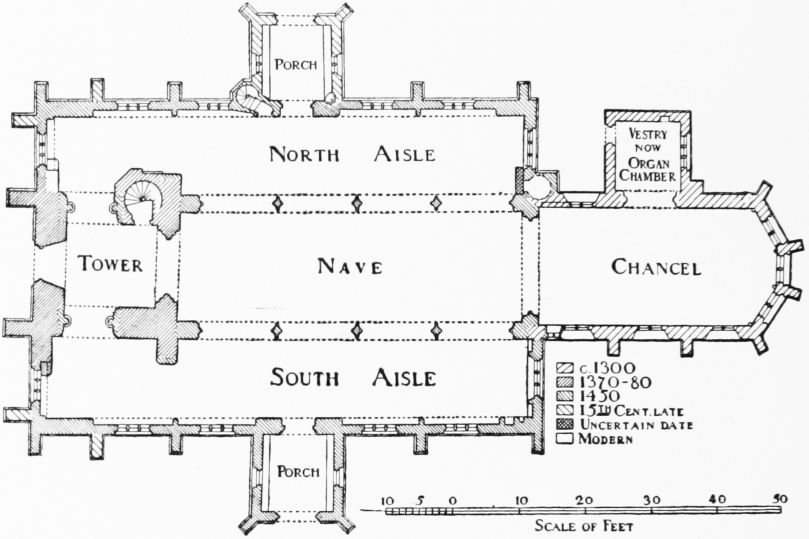
Plan of Bluntisham Church
The roof is of 15th-century date, with moulded tie-beams and jack-legs with tracery panels in the spandrels. The stone corbels are carved with figures of angels playing musical instruments, etc.
The north aisle has a three-light east window; the north wall has four three-light windows each set in an internal wall recess with a two-centred arch, a doorway with jamb-shafts and moulded arch, and a small doorway to a turret staircase; the west wall has a window and wall recess similar to the others. The roof is of flat pitch and of 15th-century date.
The south aisle is similar to the north, but the east window has a niche on each side, and there is no turret doorway. At the eastern end of the south wall is a cinquefoiled ogee-headed piscina with a quatrefoil drain, and adjoining it is another small recess; immediately above these two is a low and broad cinquefoiled ogee-headed recess, of 14th-century date.
A few 15th-century floor tiles remain at the east end. The roof is modern. The slopes of the earlier aisle roofs are indicated on the fragments of the old west walls which flank the north-east and south-east angles of the tower.
The west tower is of three stages with a moulded plinth and embattled parapet. The eastern arch is original, two-centred and of three orders. The north and south arches are of clunch and were inserted in the 15th century, and the west door and three-light window are of the same date. The second stage has a single pointed light on each side, and the belfry windows are two-lights with restored mullions and tracery. The octagonal spire rising from within the parapet is 122 ft. high from ground to the top; it has three tiers of lights, the first and third on the cardinal faces. The stair turret at the north-east corner is finished at the top with a stone vault.
The north porch has a moulded arch, cinquefoiled and subcusped, inclosed within a segmental pointed arch, and above it is a cinquefoiled niche with crocketed ogee canopy. The side walls each have a twolight window. The porch formerly had a chamber over it, the weathering of the roof still remaining on the aisle wall; but the chamber has been removed and the porch reroofed lower down. The stair-turret remains and is finished with a pyramidal capping above the coping of the aisle parapet; the lower part of the doorway into the chamber may still be seen in the west wall. There is a stoup in the south-east corner of the porch.
The south porch has a moulded arch with a niche over it, and two-light windows in the side walls. On the parapet is an inscription—1656, T.D.—G.P.: T.S.—c., doubtless the date of repairs.
The font is octagonal, the bowl of stone, of about 1500, with quatrefoil panels, grotesque faces, leaves and flowers; the stem of clunch with panelled sides and moulded base, somewhat earlier.
On the walls of the chancel are monuments to the Rev. Samuel Saywell, S.T.P., rector, 1708, and his sister Sara, wife of Andrew Mieres, 1720; the Rev. Samuel Knight, S.T.P., rector, died 1746, aged 72; Margaret (Smelt), wife of the Rev. Richard Tillard, died 1841, aged 60; a window to the Rev. Richard Tillard, M.A., rector 45 years, died 1850, aged 85. On the floors are traces of two incised crosses, matrix of brass to civilian and wife, c. 1460, and slabs to Th- - - - arrington, 1713, aged 76; Richard Drury, of Colne, d. 1738, aged 64, and Joyce, his wife, d. 1752, aged 78, parents of Sir Thomas Drury, of Overstone, Northts., bart.; Ratford Grimditch, d. 1748, Elizabeth his wife, d. 1747, and Thomas their eldest son, d. 1780; Robert Grimditch, d. 1792, aged 57; the Rev. John Jacob Oakes, M.A., rector, d. 1796, aged 72; Dorothy, his wife, born 1730, d. 1780; Dorothy, his daughter, d. 1826, aged 69. In the churchyard is a table-tomb to Adrian Lucas, 1672, with curious inscription.
There are eight bells, inscribed: To the Glory of God and in loving memory of Thomas Edwards, MCMX; Quinque natu majoribus sum addita, MCMX, John R. Wormsley and Alfred King, Churchwardens; Willm. Dobson, Founder, Downham, Norfolk, 1832; Miles Graye made me, 1632; Thomas Newman made me, 1717, recast MCMX; Thomas Skeeles, Tho. Hovson, Churchwardens, 1716; Geo. Key and Aron Brown, juner, Churchwardens, 1801, Robt. Taylor, St. Neots, Founder; Gloria in excelsis Deo. Henry Sayers, Rector, and Arthur David Godfrey, sometime warden, gave me, MCMX.
In 1552 there were three bells. All were repaired in 1910, but they have no wheels and are only chimed.
There are small traces of wall paintings over the north door and at the east end of the south aisle.
The church plate consists of: A chalice and cover, of 1569, with incised ornament and egg and tongue; a standing paten inscribed 'Bluntisham in Coun. Hunt. Ex Oblationibus, 1693'; a plate of 1702 is inscribed 'Bluntsham in comitatu Huntingdoniensi ex Oblationibus'; a flagon, of 1705, inscribed 'Bluntsham Ex Oblationibus'; a plain unmarked salver.
The registers are: (i) Baptisms, marriages and burials, 1586 to 1649, some leaves lost; (ii) copy of (i); baptisms, marriages and burials, 1538 to 1641; (iii) baptisms, marriages and burials, 1649 to 1650 and 1705 to 1767, marriages ending in 1754; (iv) marriages 1754 to 1801; (v) marriages 1801 to 1812; (vi) baptisms and burials 1768 to 1812. Also the usual modern books.
ADVOWSON
A church and a priest are returned under Bluntisham on the land of the Abbey of Ely in the Domesday Survey (1086). The church continued to belong to the abbey until the creation of the Bishopric of Ely in 1108, when it passed to the bishop. The advowson continued to belong to the Bishops of Ely until 1653, when, on the sale of the bishop's lands by the commissioners under the Commonwealth, it passed to Robert Blackborn, (fn. 47) who sold it to Valentine Walton, the regicide. (fn. 48) At the Restoration the advowson was returned to the bishop. The Bishops of Ely held it until after the readjustment of the dioceses in 1836, when the Ecclesiastical Commissioners arranged a redistribution of patronage. The presentation in 1852 came into the hands of the Bishop of Peterborough. Under an Order in Council of 1879 he exchanged Bluntisham cum Earith for five livings in his diocese (Daventry, Market Harborough, Great Bowden, Ravensthorpe and Badby-cum-Newnham) which belonged to the dean and chapter of Christ Church Cathedral, Oxford. The dean and chapter of Christ Church are the present owners of the advowson.
There was a chapel of St. James at Earith which is described as in Earith Fen, (fn. 49) no doubt somewhere on the site of the yard of the Anchor Inn on the east side of Chapel Way between the north side inn and Chapel Pond. It was associated with a 'Boyes Guild.' Somewhere near Earith Bridge was another chapel also called Capella de Erythe, dedicated to St. Mary, which was known as the Hermitage, or Armitage. (fn. 50) This latter chapel was used for ordinations as late as 1569. (fn. 51) It would seem that both these chapels were sold in 1571. (fn. 52) Stones that evidently belonged to the chapel of St. Mary were removed in 1925 by the County Council and used to repair bridges. They had been built into a farm house.
CHARITIES
Thomas Beldam by his will proved in the Principal Registry on 1 March, 1918, gave to the rector and churchwardens of Bluntisham Church the sum of £250 to be used by them for the restoration or upkeep of the church as they may in their discretion think fit.
The Pindard and Processioning Charity. Out of this charity the pinder or keeper of the pound or the haywarden was paid and refreshment for those who beat the bounds was supplied until about 1825. The endowment of this charity consists of 4 acres of land let to Mr. C. Godfrey for £4 per annum. Of this amount a yearly sum varying from £1 to £2 10s. is paid to the trustees of St. Thomas's Charity for distribution to the poor, and the remainder, after payment of land tax and tithe, was applied towards the crier's retaining fee of 5s. The charity is administered by the rector and one other.
The Rev. Samuel Saywell by his will dated 1708 devised land called the Three Acres to the minister and churchwardens of Bluntisham and Earith; the rents and profits to be employed on mending and repairing Church causeways belonging to the parish. The land, containing 2 a. 3 r. 17 p. of pasture land, situate at Holme Drove, Earith, is let for £9 5s. yearly, which, after paying land tax and tithe, is expended in road repairs and hedge trimming. The rector and two trustees administer the charity.
The same donor by his will as above devised to the poor of Willingham and Bluntisham with Earith a droveway in the parish of Willingham; the rents to be equally divided between the poor of the two parishes. The herbage of the droveway, which passed over an estate called Queens Holme and extended over about six acres of land, was let, and the rent was divided into four shares, two of which were appropriated to the poor of Wellingham, one for the poor of Bluntisham, and one to the poor of Earith. The endowment of the charity for Bluntisham and Earith now consists of £178 16s. 1d. Consols with the Official Trustees, producing £4 9s. 4d. annually in dividends, which are distributed with other charities known as St. Thomas's Charity, to the poor of Bluntisham and Earith.
St. Thomas's Charity, The Dole money, etc. The following annual sums arising under the following charities are distributed by the rector and churchwardens on St. Thomas's Day to the poor of Bluntisham in doles.
The sum of £2 4s. 8d. received in respect of Saywell's Charity representing the moiety for Bluntisham.
An annuity of £1 17s. out of land at Bluntisham, being the amount of certain rent charges given by different benefactors.
The yearly sum of 13s. 4d. payable to the poor on the 21 Dec. under the will of Bennett Skeeles dated 21 July, 1710, out of a cottage and garden.
St. Thomas's Charity, Dole money, etc. The funds arising under the following charities are distributed on St. Thomas's Day to the poor of Earith in doles.
The sum of £2 4s. 8d. received in respect of Saywell's Charity, representing the moiety for Earith.
The rent of two acres of land at Earith let to Messrs. A. and L. Beldam for £23 per annum.
The rent of 4 acres of copyhold land in the parish of Sutton in lieu of which land in the Medlands in Sutton containing 1 a. 3 roods, was awarded by the Commissioners appointed for inclosing lands in the parish of Sutton. The land was sold in 1919 and the proceeds invested in the purchase of £93 15s. 4 per cent. Funding Stock with the Official Trustees producing £3 15s. annually in dividends.
An annuity of 6s. 8d. per annum payable out of copyhold land at Sutton Medlands now in the occupation of Mr. Fitch. This annuity is supposed to have been given by the Rev. Samuel Knight for the poor of Earith.
Earith Town Estate. This estate comprised in deeds dated in 1608 and 1659 is vested in trustees upon trust to apply the rents for the sole benefit of the inhabitants of Earith, as the trustees should deem most expedient. The property consists of 9 a, 3 r. 34 p. of heathland—the Town Wash containing 5 a. 1 r. 17 p., Coronation Field containing 4 a. 3 r. 30 p. the Chapel Close containing 2 r. 4 p. and two dwellinghouses; the whole producing £78 (approx.) annually. The income is expended in town lighting, subscriptions to the Nursing Assocn., Huntingdon Hospital and Addenbrooke's Hospital, together with the yearly sum of £20 towards the replacement of £400 borrowed from Margaret Brown's Charity.
Margaret Brown by her will proved in the Principal Registry on the 25 Nov. 1910 gave a sum of £400 to the feoffees of the Earith Town Charities, the income to be applied in or towards keeping up the public lamps in Earith and for keeping in good repair the shelter in the allotments which abut on the St. Ives Road between Earith and the Church. The said sum of £400 has been advanced upon loan to the Trustees of the Earith Town Estate towards the purchase of 4 a. 1 r. 5 p. of land in East End, Earith, upon the security of an order of the Charity Commissioners, dated 24 Oct. 1911. The loan is being repaid by annual instalments of £20.
William Maile by an indenture dated 9 May 1885 directed that the rents arising from the land and two cottages situate in High St., Earith, together with the land and cottage at Bridge Hill, Earith, be distributed in equal shares between the Baptist Meeting House at Bluntisham, the Wesleyan Chapel at Earith and poor widows of Earith. The property was sold in 1916, and the proceeds invested in the purchase of £300 5 per cent. War Stock, 1929–47, in the name of the Official Trustees. The income, amounting to £15 annually in dividends, is distributed by ten trustees in accordance with the directions contained in the Deed.
Blanche Prentice by her will dated June 1807 gave a rent-charge of £2 per annum issuing out of 4½ acres of land in Earith Fen, which is distributed on Good Friday to 24 poor widows of Earith.
The Wesleyan Methodist Chapel comprised in a surrender dated 11 Oct, 1828, an indenture dated 24 April, 1861, is regulated by a scheme of the Charity Commissioners dated 19 April, 1905. ('The Wesleyan Chapel Model Deed.')