A History of the County of Leicestershire: Volume 5, Gartree Hundred. Originally published by Victoria County History, London, 1964.
This free content was digitised by double rekeying. All rights reserved.
J M Lee, R A McKinley, 'Burrough on the Hill', in A History of the County of Leicestershire: Volume 5, Gartree Hundred(London, 1964), British History Online https://www.british-history.ac.uk/vch/leics/vol5/pp61-68 [accessed 30 April 2025].
J M Lee, R A McKinley, 'Burrough on the Hill', in A History of the County of Leicestershire: Volume 5, Gartree Hundred(London, 1964), British History Online, accessed April 30, 2025, https://www.british-history.ac.uk/vch/leics/vol5/pp61-68.
J M Lee, R A McKinley. "Burrough on the Hill". A History of the County of Leicestershire: Volume 5, Gartree Hundred. (London, 1964), British History Online. Web. 30 April 2025. https://www.british-history.ac.uk/vch/leics/vol5/pp61-68.
In this section
BURROUGH ON THE HILL
Burrough on the Hill lies on the western edge of the uplands of east Leicestershire, about twelve miles north-east of Leicester. The ground falls from nearly 700 ft. in the north-east of the parish to 350 ft. in the south-west. At the extreme northeast is the earthwork known as Burrough Camp, (fn. 1) an Iron Age fort which occupies a promontory and commands a wide view of the Wreake valley. The ancient parish consisted of 1,565 a., but this area was increased in 1936 when the civil parish was united with that of Somerby, (fn. 2) in Framland hundred. The following account deals only with the ancient parish of Burrough on the Hill.
Burrough parish formed part of a detached portion of the hundred of Gartree lying north-east of the main area. The eastern and western boundaries of the parish were also those of the hundred, but in the north the two boundaries do not appear to have coincided, (fn. 3) and part of the parish was formerly regarded as being in Framland hundred. (fn. 4) The eastern boundary of the parish, dividing it from Somerby, followed an irregular course southwards from Burrough Camp. The southern boundary followed a winding stream which joins the River Wreak near Syston. A small northern tributary of this stream originates in the parish and is fed by several springs which rise on the western slopes of Burrough Hill. The tributary formed part of the western boundary which, at its southern end, followed the road from Burrough to Twyford.
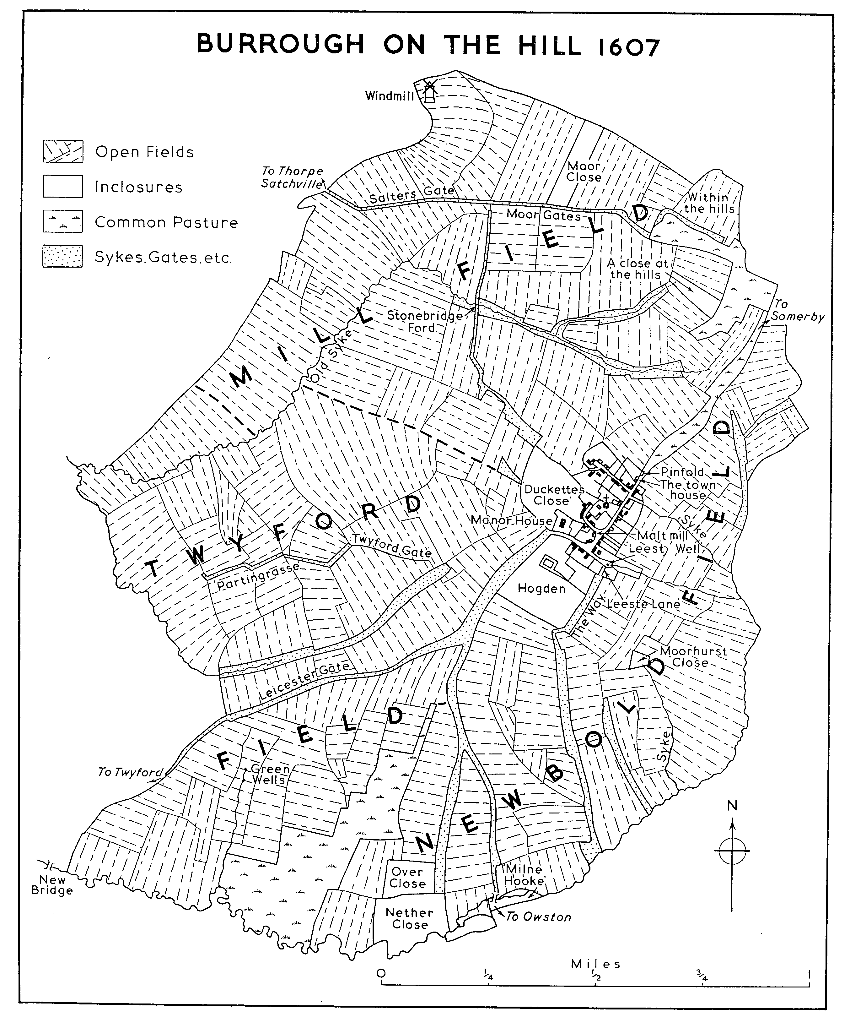
The village lies on a south-western spur of high ground, only 100 ft. lower than the main plateau and connected to it by a narrow ridge along which runs the road from Somerby. This road becomes the village street and descends steeply towards Twyford. Beyond the village it is joined by a road leading north to Great Dalby and, about 500 yds. further on, by a lane forking south to Marefield and Tilton. In the village itself a smaller track leads southwards to Newbold and Owston. A map made in 1607, (fn. 5) showing the parish immediately before inclosure, indicates several of these roads, including those to Twyford (then called Leicester Gate) and to Marefield; at Burrough Hill in the north a continuation of the road from Somerby skirted the south side of the earthwork and descended the western slope of the hill towards Thorpe Satchville (Moor Gates and Salters Gate), and in 1959 this was still in use as a farm track. Part of the present road to Great Dalby was also in existence in 1607 but it does not appear to have continued northwards beyond its junction with the old road to Thorpe Satchville.
The railway from Bottesford to Market Harborough crosses the south-western tip of the parish. It was opened in 1879 and a station was built on the road to Twyford about a mile from the village. (fn. 6) This was named John o'Gaunt after a fox covert lying over a mile to the south near the junction with the branch line to Leicester. The railway is carried across the small valley at the southern boundary of the parish by a brick viaduct of 14 arches. The line was closed to passenger traffic in 1953 but in 1956 one train ran daily from Leicester to John o'Gaunt. The John o'Gaunt Dairies, a milk bottling factory, had been built near the station by 1932 (fn. 7) and was still operating in 1956.
BURROUGH ON THE HILL 1607
Based on a map of 1607 at Brasenose College, Oxford. The direction of strips within the furlongs is indicated, but no attempt has been made to show individual strips.
The soil of the parish is largely boulder clay. The village itself stands on a small island of sand and gravel. Most of the land is under pasture and the parish is almost wholly agricultural. In 1607 a well called 'Leeste Well' was situated a short distance along the lane to Owston. (fn. 8) The village is still supplied with water from wells and local springs but during the Second World War a supply from Somerby was installed for the use of troops stationed in the area. (fn. 9) In 1959 a reservoir was being excavated at Burrough Hill in connexion with the River Dove water scheme. (fn. 10)
The size and layout of the village, with its main street and side lanes, has changed little since 1607. The church stands near its centre with the Rectory to the south-west of it. In 1607 the manor-house of the Burrough family stood on the north side of the road at the south-west end of the village. It was still in existence in 1791, when it apparently retained several medieval features and a chimney built in 1569. (fn. 11) By 1839 the house had been demolished and the site was known as Hall Close. (fn. 12) Foundations were uncovered in about 1948 when pre-fabricated bungalows were erected in the area. (fn. 13)
Ironstone is the predominant building material in the village and many of the houses date from the 18th and early 19th centuries. Earlier buildings include two small 17th-century houses on the southeast side of the main street. One, at its northern end, retains moulded stone window-heads; the other, which is L-shaped in plan, is now the post office. In a side lane to the north of the church are two farm-houses of 16th- or early-17th-century origin. The Limes, at the end of the lane, has an ironstone north wing of this period, retaining an original doorway and fragments of carved panelling. A house in this position existed in 1607, when it was the property of Brasenose College, Oxford, and was let to Thomas Porter. (fn. 14) The south wing has a symmetrical red-brick front with stone dressings and was rebuilt in 1752. (fn. 15) Nearby is Cheselden Farm on a site also formerly belonging to Brasenose and in 1607 occupied by Richard Mulsho. (fn. 16) The house consists of a central block flanked by gabled cross-wings, one having a cellar. The wings are of ironstone, probably of early-17th-century date, but the central portion was evidently raised in height and rebuilt in brick c. 1700. Externally it has flat stone architraves and string courses; the roof formerly contained dormer windows. In the hall are remains of Corinthian pilasters.
In the main street opposite the church is a tall brick house known as the Manor, built in 1781 probably by Robert Peake. (fn. 17) It belonged to Brasenose College until the sale of their property in 1941 (fn. 18) and it is not known when it acquired its present name. In the middle of the front is a threestoried block, its central bay enclosed by a roundheaded recessed panel and surmounted by a pediment. The side wings of two stories, each with its central round-headed window and pediment, are like smaller replicas of the main block. In proportion to its size the whole front is over-weighted with window openings and other features. It was almost certainly with reference to this house that Throsby, visiting Burrough in 1790, wrote that 'one dwelling, built by a grazier, may please its owner as a doll does a child'. (fn. 19) Several alterations, including the addition of bay windows, were made by later tenants.
By the early 20th century there were three large houses in the parish used as hunting boxes or occupied by hunting families. The first was Burrough Hall or Burrough Hill House, built in 1876 by C. W. Chaplin (fn. 20) on high ground to the north-east of the village. It is a stone mansion in the Tudor style and is surrounded by gardens and plantations. Some of the outbuildings, as well as additions made by the second owner Maj. A. Coats, were demolished after the Second World War. By 1900 Maj. W. A. Peake was living at Burrough House, (fn. 21) a former farm-house in the village street near the lane to Owston. It had been much extended and a large stable court and cottages built to the west. Later it was occupied by Sir Raymond Greene, Bt. (d. 1947). The third house belonging to this period was Burrough Court which formerly stood half a mile from the village on the road to Twyford. It was built c. 1905 by H. C. Allfrey (fn. 22) and later belonged to Marmaduke, Viscount Furness (d. 1940), (fn. 23) who used it as a hunting box. Between the world wars it became a well-known meeting place for the hunting society of Melton; in the autumn of 1930 the first meeting between Edward, Prince of Wales, and Mrs. Wallis Simpson (later Duke and Duchess of Windsor) took place there. (fn. 24) The house, which was burnt down during the Second World War when it was requisitioned for troops, is said to have been in a low-built farm-house style. (fn. 25) A stable court and three cottages, all with rough-cast walls and stone slate roofs, were still standing in 1959. The land was being farmed as part of the Burrough House property.
In 1908-9 old cottages north of the Manor were replaced by two stone-built groups, one by Brasenose College and the other by Major Coats. (fn. 26) There is one inn, the 'Stag and Hounds', an early-19thcentury building at the south-west end of the village. The John o'Gaunt Hotel, formerly used in connexion with the railway station, became a private house in 1958. Apart from 10 Council houses, erected near the 'Stag and Hounds' in 1955, (fn. 27) there has been little recent building in the parish.
The Iron Age fort at Burrough Hill gives Burrough its name. The village was formerly called Erdeborough, a name which survived until the last quarter of the 19th century, (fn. 28) although probably by then in a consciously archaic way. The fort itself was perhaps known as 'Miccilberuhill' c. 1260. (fn. 29) Leland recorded that in the 16th century 'to these Borow Hills every year on Monday after Whit Sunday come people of the country thereabout, and shoot, run, wrestle, dance, and use like other feats of exercise'. (fn. 30) Burton states that such sports used to take place, (fn. 31) but they had apparently been discontinued in his day; they were revived later and again abandoned in the 18th century. (fn. 32) In the early 19th century the Melton Hunt established a race meeting at Burrough on the Wednesday after the second Sunday in June. (fn. 33) These races were held until about 1870 (fn. 34) and in 1871 a large number of strangers were at Burrough for the steeplechases on 2 April when the census was taken. (fn. 35) These particular races were more likely to have been at Melton. In 1955 games were played on the hill on Whit Monday, but this does not seem to have been an annual practice.
The recorded population of Burrough in 1086 was 17; (fn. 36) the number of persons paying the poll tax of 1381 was 59. (fn. 37) In 1563 23 households were returned, and in 1670 27. There were 80 communicants in 1603 and 60 in 1676. The population during the 19th century never exceeded 200. During the 20th century the number increased to 214 in 1931, the most rapid rise being from 149 in 1901 to 200 in 1911. (fn. 38) In 1951 the population of the ecclesiastical parish of Burrough was 197. (fn. 39)
William Cheseldene, F.R.S. (d. 1752), surgeon and anatomist, was born at Burrough in 1688. (fn. 40)
MANOR.
The multiplicity of holdings in Burrough on the Hill which is recorded in Domesday Book is reflected throughout the history of the parish, and is complicated by the fact that the parish and hundred boundaries did not coincide. It is difficult to see any connexion, except in one case, between the Domesday holding and the later manors. There were four holdings in Burrough in 1086. Henry de Ferrers's under-tenant Roger held 2 carucates and 3 bovates, which had been the property of a Saxon freeman, Alwold, before the Conquest. (fn. 41) Geoffrey de Wirce held one carucate, (fn. 42) Herbert the king's serjeant held 4 carucates and 6 bovates of waste, (fn. 43) and the king had 1½ carucate as part of his manor of Whatborough. (fn. 44) It may be said at once that nothing further is known of the king's holding; it seems likely that it became indistinguishably attached to Whatborough.
A similarly complicated situation existed in 1130. Robert Marmion is said to have held 3 carucates in Burrough as part of Gartree wapentake, and another 3 as part of Framland wapentake. (fn. 45) It has been suggested that in fact this is duplicated entry, but there seems to be no reason why this should be, (fn. 46) although Philip Marmion's estate at the end of the 13th century consisted of only 3 carucates. (fn. 47) Roger de Mowbray held one carucate, which he had presumably inherited from Geoffrey de Wirce. (fn. 48) The pattern of landownership which is apparent in the Middle Ages suggests that part of the Marmion estate of 6 carucates had been alienated before the death of Philip Marmion to form the manor held by Kirby Bellars Priory.
When Philip Marmion died in 1291 he possessed 3 carucates of land in Burrough, held as one knight's fee by John de Stockton from Thomas Malore, who held from Nicholas de Segrave, who held from Marmion. (fn. 49) This multiplication of intermediate tenants dates from at least 1250, when Robert de Stockton sought that Christine Malore should acquit him of the service which Philip Marmion exacted from him for his free tenement. (fn. 50) The Malore family appear in Burrough in or before 1240, and they still preserved a connexion with the village in 1347. (fn. 51) Nothing further is known of the Segraves. (fn. 52) At Philip Marmion's death his property in Burrough passed to his daughter Joan and her husband Alexander de Fryville. In 1418, at the death of Baldwin de Fryville, the family was still seised of a knight's fee in Burrough which should have descended to one of Baldwin's co-heirs, (fn. 53) but at the end of the 15th century Henry Burrough was holding his manor in chief of the king by knight service. (fn. 54)
The Stockton family, who were for practical purposes the lords of the manor of BURROUGH, appear in the middle of the 13th century. The family made considerable purchases in the village and became the under-tenants of the manor. (fn. 55) In 1383 the manor was said to have descended from an Alan de Stockton who was enfeoffed with the manor in the reign of Henry III. Before the Stocktons a Geoffrey Wildboef seems to have been the tenant. (fn. 56) The manor descended in the Stockton family, which acquired the name of Burrough at the end of the 14th century, when Robert de Stockton was the first to call himself Burrough. (fn. 57) The two names continue to the used alternately in the 15th century. (fn. 58) The Burroughs remained in possession of the manor until the late 17th or early 18th century, (fn. 59) when the manor was sold to the Brown family, owners of the manor of Leesthorpe. John Suffield Brown of Leesthorpe was lord of the manor of Burrough in 1798. (fn. 60) His son William Brown (d. 1814), Rector and patron of Burrough, left the estate to his daughter Mary (d. 1858), wife of Edwyn Andrew Burnaby (d. 1825), of Baggrave Hall. (fn. 61) The Burrough portion of her inheritance appears to have passed to her son, G. A. Burnaby (d. 1872), of Somerby Hall, patron of Somerby and Burrough, and Vicar of Somerby. His son Evelyn Burnaby was also Rector and patron of Burrough from 1873 to 1883. (fn. 62) The Burnaby estate was sold about 1895. Part of it passed to the Peake family who obtained the advowson, but the manorial rights apparently lapsed. (fn. 63)
The manor which was held in the 14th century by the priory of Kirby Bellars may originally have formed part of the estate of the Marmion family, although it is not known exactly when or how it was alienated. Roger Beler, the founder of the priory, was murdered in 1326. (fn. 64) One of the descendants of his co-heirs, Ralph de Cromwell, in 1376 granted a manor at Burrough to Kirby Bellars Priory, (fn. 65) and he made a further grant in 1392. (fn. 66) By 1535 the priory's manor in Burrough was valued at nearly £4 a year. (fn. 67) At the Dissolution it passed to the Crown and was granted to Sir Edward Montague in 1544. (fn. 68) Montague was licensed to alienate this manor in 1546 to Richard Burrough, lord of the other manor. (fn. 69) From this date the two manors descended together.
The carucate of land which belonged to Geoffrey de Wirce in 1086 passed by c. 1130 to Roger Mowbray. (fn. 70) It seems possible, though there is hardly any direct evidence, that this manor formed part of the property of the alien priory of Monks Kirby (Warws.), which had been founded by Wirce in 1077. The priory was dissolved in 1396 and re-established in 1399, but it was granted to the Carthusian house at Axholme (Lincs.) by Henry V. (fn. 71) It might be suggested that during these changes the priory's hold over an estate in Burrough was lost, (fn. 72) and that it somehow came into the possession of the Wastnes family of Headon (Notts.), before 1460, when Richard Wastnes held a manor in Burrough and granted it to feoffees for his own use. (fn. 73) Wirce's land was probably in the Framland part of Burrough and this manor is described as 'the manor of Burgh in the parish of Somerby'. In 1491 Thomas Wastnes and his family sold the manor to Richard Sutton. (fn. 74) In 1508 Sutton enfeoffed 11 persons (5 of whom were afterwards fellows of Brasenose College, Oxford), with the manor, (fn. 75) and in the following year, upon the foundation of Brasenose by Sutton and William Smyth, it was provided that, if the endowments for building the new college failed, distraint was to be made upon the manor. (fn. 76) In 1519 Sutton leased his property at Burrough, Somerby, and Pickwell to Brasenose, and in 1524, the year of his death, he conveyed this property to the college outright. (fn. 77) The estate consisted of the manor of BURROUGH IN SOMERBY, 5 messuages, 300 a. of land, 24 a. of meadow, 100 a. of pasture, and 7s. 8d. rent, all of which he had received from Thomas Wastnes in 1491. In 1499 he had added to this land a smaller estate in Somerby. (fn. 78) In the 18th century traces of the former ownership of this by the Mowbray family remained in the payment of 1d. a year by the bailiff of Brasenose to the bailiff of Melton. (fn. 79) The college in 1870 leased its property in Burrough for 21 years to Henry Peake who afterwards succeeded to the principal manor. (fn. 80) In 1941 Brasenose College sold 350 a. at Burrough and 260 a. in Somerby and Pickwell, which was the full extent of its holding in the district, to Mr. E. E. Cook of London for £26,500. (fn. 81)
ECONOMIC HISTORY.
The several holdings at Burrough in 1086 contained land for 6½ ploughs, and there was a recorded population of 17, including 7 bordars and 5 villeins. Henry de Ferrers's undertenant Roger and Herbert the serjeant each had 20 a. of meadow, and Herbert also possessed a tract of woodland 13 furlongs by 4. Both these holdings had increased considerably in value, Roger's from 5s. to 20s. and Herbert's from 10s. to 30s. In addition Herbert held 6 bovates of waste, valued at 2s. (fn. 82)
Little is known of medieval Burrough. In 1291 a dispute arose between John de Tateshale and Robert de Stockton about John's pasture at Somerby, upon which he claimed that the Stocktons had trespassed; animals belonging to the inhabitants of Burrough were said to have been driven along the highway in 'a place called Erburgate'. (fn. 83) In 1327 there were 15 taxpayers, including the rector. (fn. 84) Most of the men who paid the poll tax in 1381 were described as husbandmen. (fn. 85) There were no free tenants.
There were three open fields at Burrough. In 1601 these were described as Mill Field, and two fields 'towards Newbold', (fn. 86) but on the map of 1607 (fn. 87) their names are recorded as Mill Field, Twyford Field, and Newbold Field. A schedule of the tenants of Brasenose and of Thomas Burrough made at the same time shows that the college held about 11 yardlands, and Burrough over 38. This gives a rough average of 30 a. of land to each yardland over the whole parish. The college let its land and collected an average of about £10 a year in rents from Burrough in the first 50 years of the 16th century. (fn. 88) In 1538 the whole estate was leased to John Hunt for 28 years at a yearly rent of £10 2s. 9d. (fn. 89) In a new lease made in 1541 it was reduced to £9 8s. 4d. (fn. 90) Previously the college had collected its rents through a collector, but they had fallen badly into arrears by 1526 (fn. 91) and it was evidently felt that the leasing of the estate as a whole was safer.
The conditions upon which the college leased land were carefully specified in all its leases. One condition was that tenants should bind themselves to agree to the inclosure of their land if the college thought fit. (fn. 92)
In 1601 the whole parish seems to have been uninclosed, (fn. 93) although it has been suggested that as early as 1527-8 Brasenose was already inclosing land. (fn. 94) This seems unlikely. In October 1605 an agreement between the various interested owners and occupiers stated that in order to facilitate the inclosure of the parish tenants should surrender half their lands and retain the other half until their leases expired. (fn. 95) Brasenose made several fresh leases in November 1605 and their tenants entered into a bond of £40 to agree to the inclosure. (fn. 96) The first lease in which the clause about agreeing to the inclosure was omitted was made in March 1606. (fn. 97) In 1607 the commission on depopulation reported that 252 a. had been converted from tillage to pasture within the last year by several landowners. The lord of the manor, Thomas Burrough, had converted 120 a., involving the destruction of one house; St. John Burrough, his father, 40 a.; Richard Mulsho, a tenant both of Burrough and of the college, who was prosecuted for inclosure in 1609, (fn. 98) had converted a house and 30 a.; and a further 62 a. had been inclosed in several smaller parcels by tenants both of Burrough and Brasenose. (fn. 99) The college itself seems to have kept in the background and its tenants took responsibility for the inclosure.
The map drawn in 1607 showed the disposition of village and fields before the inclosure. The title of the map implies that inclosure had already begun, but only one extensive inclosed area is shown, apart from a few homestead closes round the village itself; that area was in the south of the parish, by the boundary with Marefield, where there were 2 large closes belonging to Thomas Burrough, called Nether Close and Over Close. It seems likely, however, that the map records conditions slightly earlier than 1607. (fn. 100)
It is not known when the inclosure was completed. A lease from St. John Burrough to Richard Mulsho in 1616 mentions land lately inclosed, (fn. 101) and it seems likely that the inclosures of 1606 were only the beginning of the inclosure of the whole parish, made with the consent of the lord of the manor, the college, and their tenants. The open fields had certainly disappeared by the end of the 17th century. The glebe terrier of 1674 refers indirectly to the redistribution of land entailed by the inclosure. (fn. 102) A schedule of the property of the manor of Burrough, also probably of late-17th-century date, mentions only closes of arable land. (fn. 103) The inclosure apparently involved no depopulation. (fn. 104)
Francis Mulsho of Burrough was a Fellow of Brasenose College in 1658, when he gave £20 to it, and 'widow Porter' and Richard Adcock, who were both quite small tenants of the college at Burrough, made gifts towards the building of its new chapel in the same year. William Burrough, a member of the lord of the manor's family, was educated at Brasenose, became Rector of Burrough, and gave £5 in 1658 to the college's funds. (fn. 105)
By the late 18th century the ownership of the soil of the parish had been divided between over 20 owners. In 1773 27 separate holdings were assessed for land tax, but several of these were held by the same person. In 1832 there were 25 owners, many of them not occupying their own property. (fn. 106) The parish was mainly pasture in the 19th century, and remained so in 1956. In 1801 only 57½ a. were cultivated, (fn. 107) and in 1839-43 there were 99 a. of arable and 1,456 a. of meadow and pasture. (fn. 108) From the late 19th century until the Second World War Burrough was a favourite centre for the hunting society of the district. During the 1930's the kennels of the Thorpe Satchville Beagles were at the Manor. (fn. 109)
A mill in Burrough was mentioned in 1221. (fn. 110) Thomas Burrough had a windmill in 1614, (fn. 111) and it was marked in the extreme north of the parish on the map of 1607; Thomas Burrough also had a malt mill in the village in 1607, and a piece of ground called 'Milne hooke', lying by the stream on the southern parish boundary, probably indicates the position of a former watermill. (fn. 112)
PARISH ADMINISTRATION.
The town house of Burrough is marked on the map of 1607, (fn. 113) but no later references to a workhouse have been discovered. In 1839-43, however, there were 5 cottages in the same position belonging to the parish and occupied by the poor. (fn. 114) A levy of 4d. in the £ raised £16 in 1758-9, (fn. 115) £20 was raised in 1776, an annual average of £36 in 1783-5, and £85 in 1802-3. In the latter year, 8 adults were given out-relief. (fn. 116) After 1836 Burrough was included in the Melton Mowbray Union. (fn. 117) The accounts of the overseers of the highways for 1758-1826 and of the overseers of the poor for 1758-1823 have survived. (fn. 118)
When the civil parish was united with that of Somerby in 1936, it became a ward returning 2 councillors to the parish council of Somerby which had been established with 5 councillors in 1894. After 1936 the Somerby ward returned only 4 councillors. (fn. 119) In 1958 this arrangement was still in force. (fn. 120)
CHURCH.
The church at Burrough was given, perhaps by Robert Grimbald, to Owston Abbey shortly after its foundation and before 1166. (fn. 121) The advowson remained in the possession of the abbey until the Dissolution, when it passed to the Crown. (fn. 122) An unsuccessful claim to present was made in 1383 by Robert de Stockton. (fn. 123) Although the advowson was sold to Sir Edward Montague in 1544 and passed to Richard Burrough in 1546, (fn. 124) the queen presented in 1574. A presentation was made by St. John Burrough in 1578 and thereafter the advowson descended with the two Burrough manors. (fn. 125) Two lords of the manor were themselves rectors- William Brown (d. 1814) and Evelyn Burnaby, 1873- 83. (fn. 126) The Peake family secured the advowson, and the Revd. J. D. Peake was presented to the living in 1895. (fn. 127) In 1928 Maj. A. Coats of Burrough Hall was patron. (fn. 128) The benefice was united with that of Somerby in 1954, (fn. 129) and it was agreed that the patron, Lt.-Col. F. G. Peake, should present alternately with the Diocesan Board of Patronage, patrons of Somerby. (fn. 130)
The rectory of Burrough was valued at 3 marks in 1217 and 1254, and at 10 marks in 1291. (fn. 131) In 1535 it was worth £12 net. (fn. 132) In 1831 the rectory was worth £449 a year. (fn. 133) The grant of the manor to Sir Edward Montague in 1544 included two pensions, one of 30s. which had been paid to Langley Priory before the Dissolution, and a second of 13s. 4d., formerly paid by Burrough church to Owston Abbey. (fn. 134) In 1220 the Abbot of Owston had also received a pound of incense a year from this church. (fn. 135) In 1220 the canons of St. Edith's church at Tamworth (Staffs.) took two-thirds of the demesne tithes, presumably under a gift from the Marmions, the lords of Tamworth; (fn. 136) there is no later evidence of the canons exercising this right.
In 1607 the rector held two yardlands of glebe. (fn. 137) After the inclosure the rectors held 66 a., (fn. 138) and there were 73 a. in 1843. (fn. 139) The tithes on 1,317 a., payable to the Rector of Burrough, were in 1843 commuted for £263 8s., and those on 238 a., payable to the Vicar of Somerby, for £47 12s. Land immediately north of the village, all the property in the lane on the north-east side of the church, and some closes and orchards in the village street paid tithes to Somerby, (fn. 140) and c. 1955 it was believed that this part of the village had at one time been considered part of Somerby parish for all ecclesiastical purposes. (fn. 141) The rent-charges arising from the tithes in Burrough payable to the Vicar of Somerby were redeemed in 1922. (fn. 142)
The former rectory house stands immediately south-west of the churchyard, occupying the same position as the parsonage of 1607. (fn. 143) It is built of ironstone and limestone and dates largely from about 1873 when it is said to have been modernized for the rector. (fn. 144) The lower part of the back wing survives from the older building. The house was sold in 1954 and the incumbent of the united benefices of Burrough and Somerby has continued to live at Somerby Vicarage.
The church of ST. MARY THE VIRGIN stands on high ground on the north-west side of the village street. It consists of a chancel, a clerestoried nave, north and south aisles, a south porch, and a west tower with a vestry to the north of it. The fabric is of ironstone and limestone and the roofs are of lead. The oldest parts of the church probably date from the early 13th century, and a round-headed lancet window in the south wall of the chancel may indicate a date as early as 1200. (fn. 145) A similar 'low side' window in the north wall has a pointed head. The nave arcades date from the early 13th century and consist of three pointed arches supported on circular piers with 'water-holding' bases. Hoodmoulds to the arches have carved masks as stops and keystones. Both arcades lean outwards, particularly that on the north side. The wide lancent windows of the clerestory may be of the same date as the arcades or a little later. The font is a fine example of the early 13th century. It consists of a bulbous circular bowl decorated with a band of foliage, below which is a row of pointed arches filled alternately with masks and rosettes. The stem has ten engaged shafts, the alternate vertical mouldings between them being enriched with dog-tooth ornament. A dog-tooth moulding also decorates the circular base. The lower part of the tower dates from the 13th century but the much-restored belfry stage and the arcaded parapet which surmounts it were originally built in the 14th. The parapet is decorated with ball-flower ornament and a short octagonal spire rises from behind it.
Extensive alterations to the church took place in the 14th century when the aisles were probably rebuilt and the south porch added. Several of the windows are of this date and the south aisle contains a trefoil-headed piscina. The chancel appears to have been altered at much the same period. The roofs are of low pitch; a dated timber in the nave suggests that they were renewed in 1657. The roof principals rest on medieval carved corbels. Attempts to strengthen the tower were made in the 17th century. A large buttress dated 1629 was erected in the middle of the south wall and two others were built against the west wall. In 1791 the tower was leaning to the south-west in spite of the buttresses, and was said to be in 'a very decayed state'. By 1795 it had been repaired. (fn. 146)
A restoration of the church was carried out by Henry Goddard of Leicester in 1860 when traces of the colour with which the aisles and roof had been adorned were found. (fn. 147) At the same time the font was restored and new pews, altar rails, and pulpit were installed. (fn. 148) The chancel was rebuilt in 1867 when the present east window was inserted. (fn. 149) In 1878 the tower and spire were completely rebuilt, omitting the 17th-century buttresses, and a vestry was added against the north wall. The architect was Charles Kirk of Sleaford (Lincs.). (fn. 150) The outer walls of the church were repaired in 1893. (fn. 151) After the First World War inscribed oak panelling was installed in the porch to commemorate those who served in the war.
At the east end of the south aisle is the stone effigy of a man in armour, his feet resting on a lion, and in the north aisle are the remains of a woman's effigy. These are thought to represent William Stockton (d. 1470) and Margaret, his wife. The inscriptions, which were noted by Burton, have disappeared. (fn. 152) These monuments, together with one (now missing) to another William Stockton (d. 1537) and his wife, were formerly in the north aisle where Throsby saw them in 1790 and remarked that they were 'treated as rubbish'. (fn. 153) A mural tablet in the north aisle commemorates Edward Cheseldyn (d. 1691), his mother-in-law, wife, and daughter (1691-1718); another is to Charnel Cave (d. 1792) with members of his family (1787-1833). There are also tablets in the church to William Brown (d. 1814), rector; to Evelyn Burnaby, rector, 1873-83; to his wife and infant daughter (d. 1873); and to his father, the Revd. G. A. Burnaby (d. 1872). Other tablets include those to W. A. Peake (d. 1912) and Sir Raymond Greene, Bt. (d. 1947). Stained glass windows are in memory of members of the Peake, Burnaby, and Chaplin families.
The plate includes a silver cup with cover paten of 1670. A silver cup and flagon were given by Frederick Peake in 1870. (fn. 154) There are 4 bells: (i) and (ii) 1600 and 1609, both recast in 1798; (iii) 1619; (iv) 1730, recast in 1813. (fn. 155) The registers date from 1612 and are complete.
NONCONFORMITY.
None known.
SCHOOLS.
In 1508 10 pupils of a school organized by the Rector of Burrough attested a charter of Richard Sutton to Brasenose College. (fn. 156) Nothing else is known of this school which was probably a private venture of that rector.
In 1833 there were 3 private schools in Burrough: an infants' school with 17 children, a day school (begun in 1833) with 5 girls, and a boarding school with 7 boys. The church Sunday school with 26 children was run by subscription. (fn. 157)
Burrough National School, a small brick building on the road to Somerby, was erected in 1873 by public subscription to accommodate 80 children. (fn. 158) By 1910 the average attendance was only 21. (fn. 159) In 1929 it was decided to confine this school to juniors by sending the seniors to Melton Mowbray. (fn. 160) In 1933 the average attendance of juniors was 12. (fn. 161) As Burrough (C. of E.) School in 1955 it adopted 'controlled' status instead of 'aided' status which it had previously enjoyed. (fn. 162) The attendance of juniors and infants in 1957 was 29. (fn. 163)
CHARITIES.
None known.