A History of the County of Middlesex: Volume 12, Chelsea. Originally published by Victoria County History, London, 2004.
This free content was digitised by double rekeying. All rights reserved.
'Settlement and building: Twentieth century, up to the second world war', in A History of the County of Middlesex: Volume 12, Chelsea, ed. Patricia E C Croot (London, 2004), British History Online https://www.british-history.ac.uk/vch/middx/vol12/pp79-90 [accessed 30 April 2025].
'Settlement and building: Twentieth century, up to the second world war', in A History of the County of Middlesex: Volume 12, Chelsea. Edited by Patricia E C Croot (London, 2004), British History Online, accessed April 30, 2025, https://www.british-history.ac.uk/vch/middx/vol12/pp79-90.
"Settlement and building: Twentieth century, up to the second world war". A History of the County of Middlesex: Volume 12, Chelsea. Ed. Patricia E C Croot (London, 2004), British History Online. Web. 30 April 2025. https://www.british-history.ac.uk/vch/middx/vol12/pp79-90.
In this section
UP TO THE SECOND WORLD WAR
Three main strands of change affected Chelsea up to the Second World War: efforts by philanthropic societies, local groups, and the council to improve the most deprived areas; rebuilding by private landlords to improve their income from property; and the growth in organized opposition to rebuilding, especially in Chelsea village, and to the replacement of the older buildings and to 'improvement' for the sake of it.
In the first half of the 20th century large areas of Chelsea consisted of lower middle- and working-class residents whose housing was often poorly maintained and decaying, and included pockets of great poverty and deprivation, principally around World's End. The poverty was relative, however: the upper middle-class areas around Sloane Street, seen more as part of Knightsbridge, made the rest of Chelsea seem poor, but the areas of small houses, tradesmen, and shopkeepers were not necessarily slums, and compared with seriously deprived areas of London, such as Bethnal Green, Chelsea had only modest social problems. In 1902 only about a quarter of Chelsea's population were considered in poverty, and only about 14 per cent were assessed as overcrowded. (fn. 1) In 1921, 51 per cent of the dwellings in the borough were undivided houses, 39 per cent were flats and tenements, and 10 per cent were attached to shops, offices, and warehouses. Only 13.7 per cent of the population were living with more than 2 persons to a room, (fn. 2) and in 1936 only the equivalent of 6.6 per cent of the population of the borough, 749 families, were deemed overcrowded. (fn. 3)
Chelsea was prevented from falling into the worse type of multi-occupation by the control exercised by some ground landlords, whose leases prevented the lessees converted their houses into flats, but because demand for large houses had dwindled in most of London, such leasehold houses were standing empty, while the landowner received a good ground rent and the lessees had covenants to keep in repair. The lessees' plight was reported by a Chelsea householder who had a large house in a street of mostly very small houses, shops, and flats, and was subject to a high ground rent: no-one would take the house as a whole, and the leaseholder could not take in tenants, which meant there were 11 unused rooms. (fn. 4) Where there were no such restrictions many larger houses were converted into flats, such as no. 8 Chelsea Embankment (Clock House) and nos 9-10 (Turner's Reach House), both converted by 1927. (fn. 5)
Crosby Hall
While rebuilding generally meant the loss of older buildings and replacement by new, one particular rebuilding scheme brought Chelsea its oldest building. When efforts in 1907-8 to prevent the demolition of Crosby Hall, Bishopsgate (City of London) were unsuccessful, the owners of the building gave the fabric to the LCC for preservation for public benefit. University and City Association of London Limited put forward a scheme to re-erect the hall in connection with More House, Chelsea Embankment, a residential institution for university students. The LCC, which owned the freehold of the site of More House, agreed to the scheme on condition the freehold of the adjoining site was purchased and transferred to the Council, the whole used for academic purposes, and arrangements made for suitable public access to the hall. The buildings were to form the University Hall of Residence, Chelsea, recognized by the University of London. Crosby Hall was reassembled in 1909-10 along the south-western end of Danvers Street. (fn. 6) In 1922 the British Federation of University Women launched an appeal for funds for their scheme to build a new wing at Crosby Hall as an international residence for visiting women graduates. The new wing, at right-angles to the medieval hall and built of light red brick with stone dressings, was opened by Queen Mary in 1927. (fn. 7)
PHILANTHROPIC, PUBLIC, AND OTHER SOCIAL HOUSING BEFORE 1914
Working-class housing was provided by a number of agencies in the first half of the 20th century, with some receiving assistance from local landowners, particularly the Cadogan Estate. Though the Sutton Trust bought its site at market rate, the Lewis Trust and the borough council received land at low or even freely to provide such housing: the gifts of land were variously attributed to guilt over displacing so many people as leases fell in, or to the desire to remove poor housing encumbering the estates while retaining some necessary local labour in the vicinity. (fn. 8)
Before the First World War two large estates were built by philanthropic housing trusts in Chelsea. In 1908-10 the William Sutton Trust bought for £85,000 most of the triangular site at the west side of the former common, bounded by Leader Street (renamed Ixworth Place), Cale Street, and College Street (renamed Elystan Street), and including Marlborough Square. It covered 4.5 acres, and the Trust replaced the small crowded houses with the largest estate hitherto built by any of the four major housing trusts in London. The 14 red-brick blocks of model dwellings, designed by E.C.P. Monson, contained 674 dwellings and on completion in 1913 housed 2,200 people. (fn. 9) Rents on the estate were similar to elsewhere in London but for smaller flats: none had more than three rooms and two-thirds had only one or two. This benefitted very small households in Chelsea, who could get a Sutton tenancy at a relatively cheap rent, especially since cheap private rented accommodation was disappearing, and many of the beneficiaries of the Sutton flats were women in service jobs on low incomes. (fn. 10) Small houses and alleys were also cleared on the north side of Ixworth Place, where eight blocks of model dwellings were built in 1913 by the Samuel Lewis Housing Trust, completed after the First World War and housing 1,390 people. (fn. 11)
One industrial dwellings company continued to build in Chelsea around 1900. On the west side of Park Walk the 5-storeyed red-brick blocks of Elm Park Mansions were built c. 1900 on the site of nos 26-60 Park Walk and Daltons stable, between Winterton Place and Chapel Place, by the Metropolitan Industrial Dwellings Company, to whom Major Sloane Stanley leased the site in 1900. (fn. 12) The company also bought land on the west side of Beaufort Street c. 1902, and built red-brick terraces for better-off artisans. (fn. 13)
After 1900 the borough council also began taking a direct interest in housing working-class residents and improving some of the worse areas of Chelsea. Only a few borough councils built any public housing between 1890 and 1913, and then less than 2,000 dwellings in all. Of these, however, Chelsea was the most prolific. (fn. 14) The council bought and renovated the mid-Victorian tenements called Onslow Dwellings near Fulham Road, reopened by 1904 as 3 blocks with 108 flats, (fn. 15) and in 1905-6 they built Pond House in Pond Place nearby with 32 one- and two-roomed flats, designed by Joseph & Smithem. (fn. 16) The Cadogan Estate sold to the council 1.6 acres on the east side of Beaufort Street for just over half the market value on condition the site was used for working-class housing, and the council built the Thomas More estate, five 6-storeyed red-brick blocks with 262 self-contained flats, mostly with two or three rooms, designed by Joseph & Smithem, and opened in 1904 and 1905. (fn. 17) The council also applied successfully to the LCC Finance Committee in 1909 to borrow £18,000 to build 80 two-roomed and 40 one-roomed working-class dwellings in Grove Cottages, Manor Street; the half-acre site was given freely by Lord Cadogan on condition that the tenants had incomes of less than 25s. a week. (fn. 18) The council built 'associated' rather than self-contained flats, opened in four blocks as Grove Dwellings in 1910: the associated flats were provided with groups of 4 WCs to every 6 flats, and without bathrooms on the grounds that the municipal baths were only 200 yards away. The advantage was the cost, and meant that rents could be lower, especially for one- and two-roomed flats. (fn. 19) By 1914 the council had built 13 blocks on 4 estates with 522 flats containing 1,150 rooms. (fn. 20)
As in the previous century, clearance of the worst of working-class housing meant that not all displaced residents were rehoused. Between 1902 and 1913 3,467 rooms occupied by working-class residents were demolished, and of the sites only 763 rooms were replaced by working-class dwellings. Of the rest 953 sites remained vacant, 566 used for business premises, 522 for non working-class dwellings, 233 for public building, and 369 for street improvements. (fn. 21) By 1914 the council housed 1,580 people, and other model dwellings together housed about 5,290; it was estimated that 25 per cent of the working-class population of Chelsea lived in model or industrial dwellings in 1914. (fn. 22)
HOUSING IMPROVEMENT BETWEEN THE WARS
After the First World War both the council and voluntary organizations took steps to tackle the slums around World's End Passage, described as an area of 'sordid courts and alleys, where century-old worn-out cottages were crowded higgledy-piggledy together'. (fn. 23)
In July 1925 the Chelsea Housing Association held its first public meeting, expressing to the mayor and council its regret that no action had been taken under the recent Housing Acts, which had made local authorities responsible for addressing general housing need rather than just slum clearance, and which gave them state assistance. Later that year the Association put out a public statement of what they saw as the main requirements in the area: they wanted schemes for working-class housing providing c. 100 flats, and intended to make housing the predominant issue in the forthcoming elections, supporting candidates who pressed for building schemes. They also wanted the council to pursue the owners of unhealthy property and to make the office of medical officer full-time. A representative of one party on the council denied that their sanitary administration was not vigilant, and pointed out that there were 578 municipal flats in Chelsea. However, a report by the Association's surveyor stated that two-thirds of families lived in houses with between one and three rooms, and overcrowding was particularly acute in Church Ward, which included Cale Street, and in Stanley Ward, which included Slaidburn Street. 4,127 people lived in one-roomed dwellings, 11,261 in two-roomed, and 13,273 in 3 or more. Working-class inhabitants lived in tenements, small cottages, and the four estates of industrial dwellings in the borough, and the children had no parks or open spaces except the burial ground around St Luke's, Sydney Street. The surveyor also criticized the absence of town planning, and wanted wholesale clearance of areas such as World's End. (fn. 24)
Whether or not because of the Association's pressure on the council, by 1928 the Association could report some progress; the council's scheme for World's End (below), the lease by the council of a plot in King's Road to the Guinness Housing Trust, an increase in sanitary inspections, and support to tenants in conflict with landlords. (fn. 25) However, they were unhappy about the state of the central area near Cadogan Square, where the 'squalid condition of mean streets' needed attention; c. 3000 people lived in the 13 acres of worn-out houses, which had been acquired for rebuilding before 1914 but could not now be dealt with because of rent restrictions. The Association wanted the council to take it in hand, but the very high value of land in Chelsea prevented municipal housing there. (fn. 26) In 1929 the Association again criticized the borough council for not taking advantage of state assistance under the Housing Acts to provide housing; not one of more than 7,000 people living in overcrowded conditions had been rehoused by the council, and their delay in building new houses had put pressure on tenants throughout the borough. At the same time 966 notices had been served on the Cadogan syndicate in connection with its property in the central area, and the Association felt there was a need for permanent reconstruction there and a private Act to deal with it. (fn. 27) In 1930 their aim was not to build directly but to bring pressure on the 'quite astonishingly supine borough council'. They thought there was now a great change in people's attitudes and an interest in building, and as Chelsea had very low rates it could afford more for building. (fn. 28)
The Housing Improvement Society and World's End
Meanwhile the Chelsea Housing Improvement Society Limited was established in 1926, with an office at no. 348 King's Road: its object was to buy, sell, let, or develop land, and provide and manage houses for working classes and others. (fn. 29) Like other such housing societies, it aimed to provide housing for the very poorest tenants, generally those formerly living in slum tenements, (fn. 30) and one of its main objectives was to deal with World's End Passage, where small 2-storeyed brick cottages opened directly onto the paved lane. (fn. 31) The borough council confirmed the World's End Passage Improvement Scheme in 1928 for 1½ a. covering 78 houses and tenements in World's End Passage, Davis Place, Riley Street, Foundry Place, Lacland Cottages, Lacland Place, and Jackson's Buildings, containing 379 people in 216 rooms: 340 people were to be rehoused in the area, 39 elsewhere. The site of nos 23-6 Riley Street had been rebuilt by April 1929, (fn. 32) and 89 of the 190 rooms in the scheme were completed by the end of 1930. (fn. 33) Part of the scheme was carried out by the Chelsea Housing Improvement Society, to whom the council leased the site for 99 years at a nominal rent, and the Society spent £6,000 on building Walter House, its first block of 12 flats, opened in 1929 for 24 adults and 42 children. It then appealed for funds to build three more blocks: the four-storeyed Follett House on the site adjoining World's End Passage followed in 1930 with 17 flats for 36 adults and 45 children, and Albert Gray House in 1931 for 42 adults and 65 children in 20 flats. (fn. 34)
The rising value of land in Chelsea, as elsewhere in London, made it difficult for the established housing organizations such as Guinness or Sutton, who had built in Chelsea before the First World War, to undertake new projects in the 1920s. The Guinness Trust built one new scheme in Chelsea under the 1919 Housing Act, made viable because the borough council offered the site to the Trust on a 999-year lease at a peppercorn rent. (fn. 35) This was the 2½-acre Wimsett Nursery site on the south side of King's Road, at the corner of Edith Grove, where the Guinness Trust built 4 five-storeyed blocks in 1929-30, designed by C.S. Joseph and containing 160 working-class flats, each with a bathroom/scullery; by agreement with the council only Chelsea residents were accepted. (fn. 36)
Chelsea Housing Association reported in 1930 and 1931 on the improvements carried out through the work of the Guinness Trust and the Chelsea Housing Improvement Society, but still pressed for action over the area of c. 10 acres near Marlborough Road, which, except where sold to smaller operators, continued to be unsatisfactory. The Association resolved to ask the borough council to acquire 2 acres of the site for working-class housing and 1 acre for recreational needs. They also reported that there were still some bad landlords who were covertly threatening tenants, and the medical officer of health had issued more than 1,000 orders to landlords to improve property. (fn. 37)
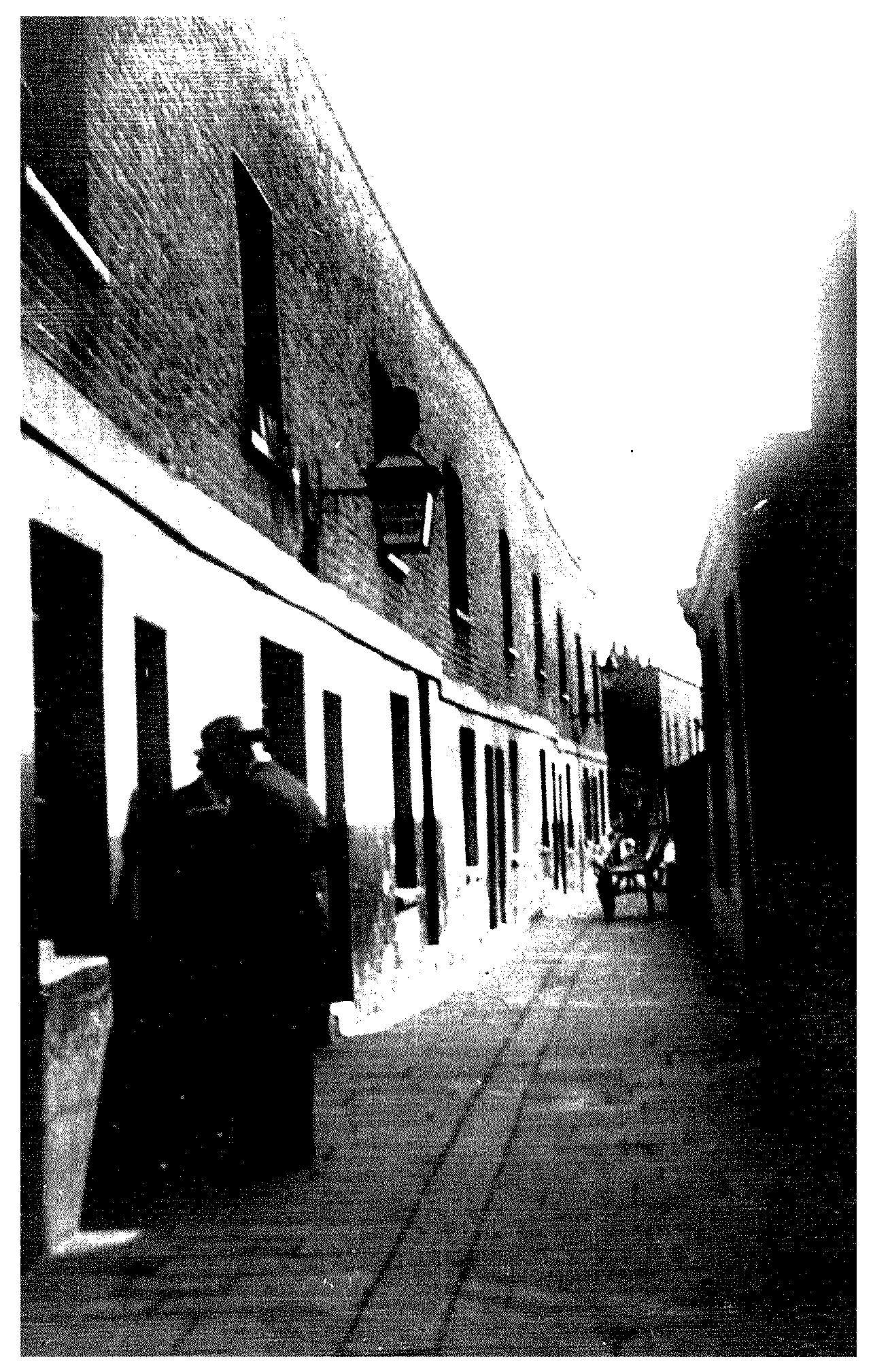
World's End Passage, 1929, looking south from King's Road. The lamp has brush on top, indicating a chimney sweep's premises
In 1933 a meeting of the Chelsea Housing Improvement Society was attended by two cabinet ministers, and Chelsea's MP, Sir Samuel Hoare, spoke about the great contrast 25 years ago between the upper class and working class parts of Chelsea. Feelings had been so bitter then that it had been impossible to hold meetings in some areas, but he believed that the two groups had come to know more of each other, and with the introduction of the housing subsidy and the current fall in building costs, clearance of slum areas should proceed faster. (fn. 38) Meanwhile the housing society felt it had been effective in fostering the growth of corporate feeling among tenants: a men's club was meeting in a workshop, and it was hoped soon to have a new club room and develop other clubs for women and girls; a children's library was well used. The years 1929-32 had seen the clearing and rehousing of World's End; in 1933 all the society's debts were paid off, and they were ready to help other schemes. (fn. 39)
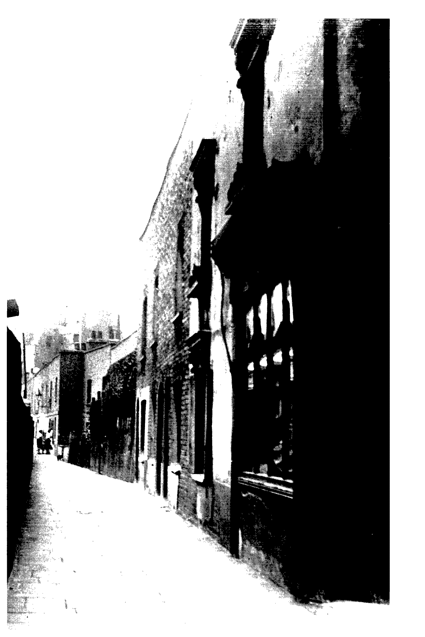
World's End Passage, 1929, looking north from Riley Street. The same view in 1969 is shown in fig. 40
Municipal Housing
Despite accusations of supineness, the council did try to prevent developments which would adversely affect working-class housing. In 1920 they sought to oppose the erection of a big motor works behind the Town Hall in the middle of a working-class residential area, but were powerless to prevent it despite the urgent need for more housing in the borough. (fn. 40) After facilitating rehousing at World's End, the council took a more active role in providing housing itself, putting forward a scheme in 1934 to demolish property in Wellington Street, behind the town hall, and housing 400 people instead of only the 260 already there. (fn. 41) The council also opened Chelsea Manor Buildings in 1939, designed by A.S. Soutar, and built on 1.6 a. with frontages to Chelsea Manor Street, Flood Street, and Alpha Place; it housed 422 people, mainly displaced by slum clearance, replacing old houses occupied by 81. (fn. 42) In 1939 the council also obtained a compulsory order to purchase a large area on the east side of Draycott Avenue between Orford and Denyer streets and including the tiny Cadogan Avenue. (fn. 43) They planned blocks of flats (Wiltshire Close) for working-class families, but building was delayed until after the Second World War. (fn. 44)
PRIVATE REBUILDING BEFORE THE FIRST WORLD WAR
The pace of wholesale rebuilding on private estates slowed in Chelsea in the decade before the First World War. Though the impetus for improvement which had begun in the last 20 years of the 19th century was sustained in eastern Chelsea, the difficulties of redeveloping estates to house affluent residents instead of the lower classes were becoming greater. Nevertheless, piecemeal rebuilding continued in areas of older settlement. By 1913 the houses of the 17th and 18th centuries which had once lined Church Street were rapidly being replaced by modern buildings rather out of keeping with the character of the street and in an indiscriminate motley of styles. Some older buildings did remain, however: eight on the west side still showed 18th or late 17th century features in 1913, and three on the east had features of the late 18th century. The early-18th century Petyt School had been rebuilt in 1890 on its original lines, though with the three arches of the cloister partly filled in. (fn. 45) In 1906 six of the row of ten houses of 1691 on the north side of Royal Hospital Road, formerly Paradise Row, nearest to Burton's Court were demolished and replaced with modern houses, despite appeals to Lord Cadogan by Lord Monkswell and several literary and artistic inhabitants. (fn. 46)
The south side of Chelsea Park still had some open ground at the beginning of the 20th century. The Vale, a small cul-de-sac entered from King's Road through a wooden gate and looking like a country lane, led to four isolated houses with spacious gardens, and the paddock behind. William and Evelyn de Morgan lived for 22 years at no. 1, a quaint rambling house with an ancient vine and fig tree, where old mulberry trees were cut down to make way for their studio, and other artists also sought accommodation there. (fn. 47) Vale Avenue, a new thoroughfare from King's Road to Elm Park Road, replaced The Vale in 1910. (fn. 48) Mulberry Walk and Mallord Street were added between 1910 and 1925 by Vale Estates Limited over the sites of Stanley Works, Camera Gardens, and the ground formerly belonging to Vale Grove house. (fn. 49) To the west, Veitch's nursery grounds had been considerably reduced when Hortensia Road was laid out across the site and several school buildings erected on the west side by 1907. (fn. 50)
At the beginning of the 20th century the Cadogan Estate, which by this date owned the freehold of more than half the area of the former common, considered how to rebuild the area between Marlborough Road and College Street, where most of the leases were due to expire in 1908-9. The houses, built about a hundred years previously, were described as of a very inferior character, inhabited by the lowest class of population: the best of the houses were in Whitehead's Grove; the remainder consisted of houses of less than 6 rooms, described as 'now unsuitable' for the locality, and hardly any were to be retained after the leases fell in. The Estate clearly wanted to redevelop the area with more upper middle-class housing, as had been done in Lower Sloane Street, instead of the modest artisan housing of the common area. However, there were now considerable obstacles. The scheme would have entailed the removal of around 700 dwellings, housing 5,700 people, including 100 in Beauclerc Buildings, a common lodging house in College Place, which would have caused the kind of uproar in the press which accompanied the clearances in Lower Sloane Street in 1888. Even if public opinion were to be ignored, the council's permission would have been required to alter the street layout, which was too narrow for the larger houses the Estate had in mind, and the council would also have required working-class dwellings to be included to accommodate the displaced population, thereby reducing the value of the property as a building estate. It had been intended to redevelop the area as an extension from the successful Cadogan Square, but this was difficult because of the intervening blocks of older housing belonging to other freeholders along the approach from that square, the very working-class public house, the Admiral Keppel, at the top of Marlborough Road, and the large board school half-way down. (fn. 51)
With all these factors in mind, in 1902 the Cadogan Estate conveyed the whole area of c. 20 a., including the blocks on the east side of Marlborough Road between Green and Cadogan streets, to the Cadogan and Hans Place Estate (no. 3) company. (fn. 52) The company presented its plan in 1908 to rebuild the area, which as predicted provoked much comment in the press, who criticized the fact that over 20,000 working-class people were being driven from the borough as leases fell in, for the enrichment of Lord Cadogan and his family, and that the working class merely represented so much lost money to the earl. (fn. 53) A start was made on the roads: Keppel Street was widened and renamed Sloane Avenue, and Marlborough Road was renamed Draycott Avenue; a westward extension of Draycott Place was cut across both thoroughfares. Several high-class houses were built at the southern end of Sloane Avenue and in Draycott Place between 1902 and 1906, as well as Cadogan Court, a large block of private flats in Draycott Avenue, but several acres cleared of houses remained unsold: 'gaping and half-demolished slums' led out of Sloane Avenue, and Draycott Avenue remained unchanged. (fn. 54) Most of the streets in the area were renamed in this period, but nothing more was done until the late 1920s. (fn. 55)
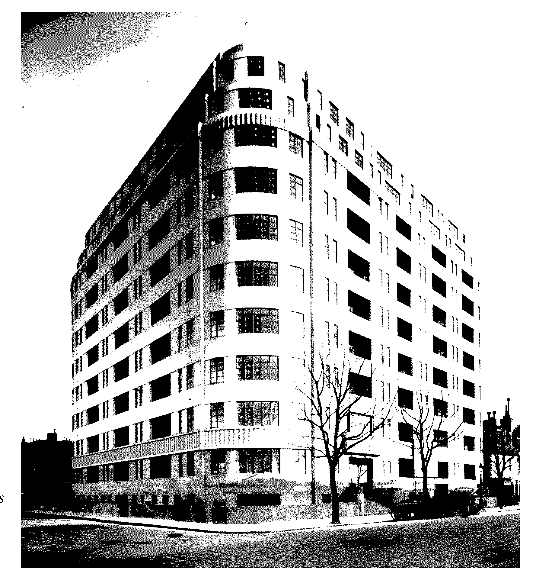
Sloane Avenue Mansions 1934, corner of Sloane Avenue and Whitehead's Grove
At the north end of the area, however, the factory for Messrs Michelin, motor-tyre manufacturers, designed by François Espinasse, was built 1909-11 at no. 81 Fulham Road, with a service bay on the ground floor and offices above. The concrete structure was entirely concealed by ebullient and colourful decoration, mainly in tiles including 34 pictorial tiled panels of racing-car successes to advertize the virtues of Michelin tyres. (fn. 56) Also in Fulham Road Thurloe Court, a block of private flats, was built shortly before the First World War. (fn. 57)
REBUILDING BETWEEN THE WORLD WARS
In 1927 an observer of London's development commented that the embellishment of Chelsea, by which he meant rebuilding in a modern style, belonged almost entirely to the period before the Great War and he thought it was doubtful whether any other part of London had seen so few new buildings erected during the early post-War period. (fn. 58) However, replacements and small-scale rebuilding continued in the 1920s, mainly in the old village area, and in 1932 redevelopment took place on part of the Sloane Stanley estate, especially nos 1-5 Petyt Place and 68-70 Cheyne Walk near the church. (fn. 59) Sir Edwin Lutyens designed a large house at no. 42 Cheyne Walk in 1933, which was itself replaced in 1936 with a block of flats, more than 6 storeys and with a long row of garages behind abutting on the rear of houses in Cheyne Row. (fn. 60) The problem of filling large family houses was also being addressed in parts of Chelsea: in Elm Park Gardens the leaseholder was granted a licence to convert nos 99-101 on the corner of Fulham Road into five flats in 1932. (fn. 61)
In the 1930s large-scale building for middle-class residents began again after some 30 years, and because of the high cost of land it now mainly took the form of blocks of flats. By the end of the 1930s some parts of Chelsea had been radically transformed: the small terraced houses between Fulham and King's roads near Draycott Avenue were almost completely replaced by gigantic blocks of flats with underground garages, with a few streets of modern Tudor-style houses to the west. (fn. 62)
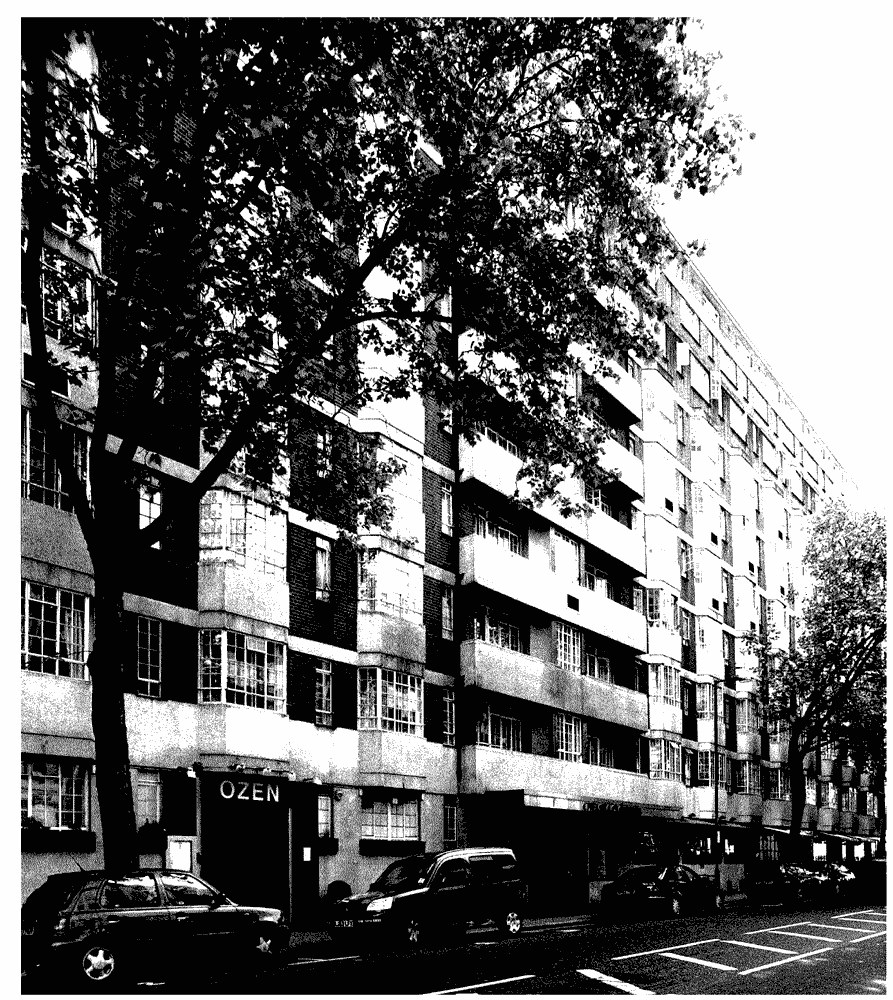
Chelsea Cloisters, Sloane Avenue
Draycott Avenue
On the partially demolished area between Draycott Avenue and Elystan Street, some vacant sites were used temporarily as motor works and garages, (fn. 63) but at the end of the 1920s building resumed. In 1929 the area still not redeveloped was sold to Sir John Ellerman, a shipping magnate, consisting of nearly 14 acres stretching from a narrow frontage on Fulham Road south to Elystan Place and from Elystan Street to Draycott Place with a block beyond reaching Rawlings Street. It included c.600 properties in 17 streets for which an improvement scheme was drawn up to clear away the existing houses and gardens, which did not reach modern standards, and develop it in a similar way to the adjoining Cadogan Estate, where at the end of the 1920s a good market for superior town houses had emerged. The estate agents described houses in Chelsea as generally of two types: the class of house for which Cadogan Square was noted; or the small early or mid Victorian house with no comforts or conveniences and desirable only for the site. (fn. 64)
Mid 19th century houses on the east side of Trafalgar Square, rebuilt as Chelsea Square in 1938
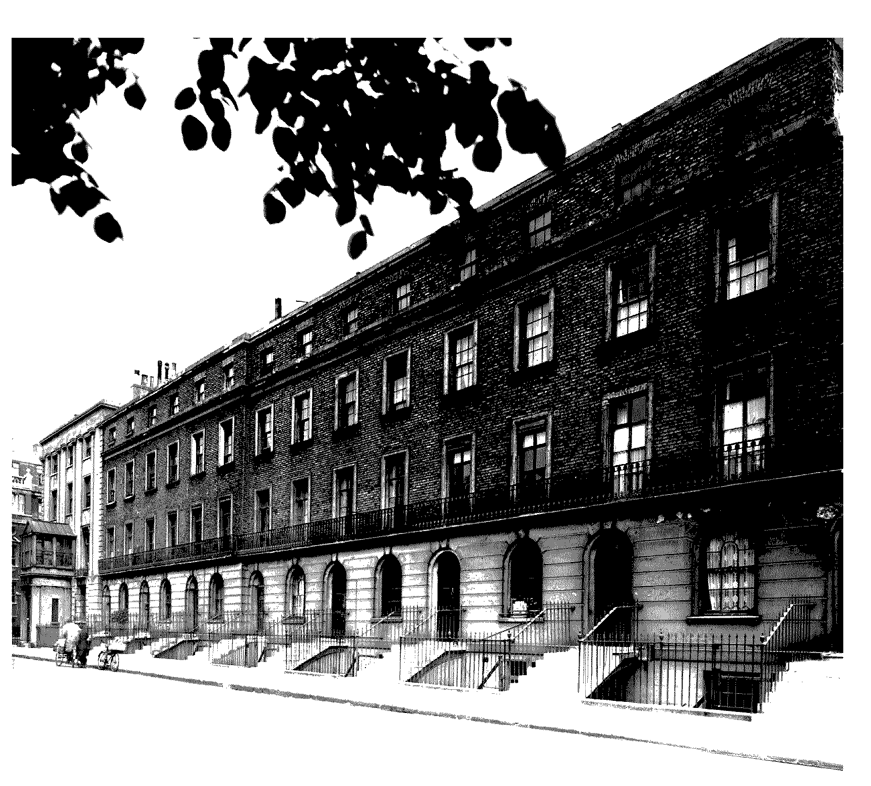
Some houses were built on the west side of Sloane Avenue either side of the junction with Ixworth Place on 99-year leases from 1929 or 1930, (fn. 65) but predominantly the housing was in blocks of flats. By the end of the 1930s this district was filled with housing for the better off, 'a curious mixture of select, consciously picturesque low houses' and enormous and forbidding blocks of flats, either cautiously Art Deco or approximately neoGeorgian in style. (fn. 66) On the east side of Sloane Avenue several semi-detached houses were built and two immense ten-storeyed blocks of flats on either side of Whitehead's Grove with second frontages to Draycott Avenue: on the south corner Sloane Avenue Mansions was completed in 1933, and on north corner the larger Nell Gwynne House, faced with red brick and with a spacious open courtyard in the centre forming the main entrance, was finished in 1937. Both had parking space in the basements, and Nell Gwynne House had a restaurant open to non-residents. On the west side of Sloane Avenue Cranmer Court, one of the largest blocks of flats in London, was built 1934-5 covering most of the block bounded by Sloane Avenue, Whitehead's Grove, Elystan Street and Francis Street (later renamed Petyward), with its main frontage facing south in Whitehead's Grove with two open quadrangles. The buildings were nine storeys high with a row of shops on the Sloane Avenue side which extended through to the first quadrangle. Further north on the west side of Sloane Avenue another vast ten-storeyed block was built 1937-8 called Chelsea Cloisters. It too opened into a spacious courtyard and filled the block bounded by Sloane Avenue, Lucan Place, Makins Street, and Ixworth Place. On the south side of Whitehead's Grove, facing Cranmer Court a group of red brick Tudor style houses was built called The Gateways, which opened into courtyards extending through to Norman Street and was described as 'not unlike ancient almshouses'. (fn. 67)
The northern ends of both Sloane Avenue and Draycott Avenue next to Fulham Road were still bordered on the east side by poor-class shops and houses in the 1940s, considered out of keeping with the neighbouring redeveloped estate in Sloane Avenue, but in Fulham Road Pelham Court was built in 1933, a large block of shops and flats facing the gardens of Pelham Crescent. (fn. 68)
On the east side of Draycott Avenue the Cadogan Estate began to demolish houses between Green Street in the north and Orford Street in the south in 1930, partly for flats and partly for the Crown. More than 20 families were evicted, but many refused to move until offered suitable accommodation, and hundreds of men, many ex-servicemen, were reported to be armed with staves and prepared to resist the bailiffs. (fn. 69)
Chelsea Square
One major redevelopment in this period did not involve large blocks of flats, but again it was intended to attract middle-class residents. The early 19th-century Trafalgar Square had been built with nearly 2½ a. of open land in the centre laid out as a garden; by the time the lease for the square expired in 1928 it was sub-let to a tennis club. When the head lease fell in the Cadogan Estate decided to redevelop the area, demolishing the existing houses and building on their sites and on about a quarter of the open ground, (fn. 70) with a small mews at the north end and more substantial houses at the south. The rebuilding also meant the demolition of the early 19th-century villa called Catharine [sic] Lodge on the west side, deplored by many local residents. The original houses in the square, described by the Cadogan Estate as nondescript and unable to be adapted to modern use, were demolished from 1932. (fn. 71) The rebuilding scheme for the whole square involved new houses designed in early Georgian style by Darcy Braddell and Humphrey Deane, and built of pinkish stock brick, with bright red brick dressings and green-glazed tiles. In 1931 six houses on the south side were completed, fronting onto the central garden, and six on the east. The four centre houses were grouped in linked pairs, along one side of a mews with flats over garages. (fn. 72) At the south-west corner Catharine Lodge was replaced by neo-Regency villas in white stucco at nos 40-1, designed by Oliver Hill and built in 1930 and 1934 respectively. (fn. 73) By 1938 the rebuilding of Trafalgar Square, renamed Chelsea Square, with its 3-storeyed houses with garages was almost complete, and demolition started on the south side of South Parade and the east side of Old Church Street. (fn. 74)
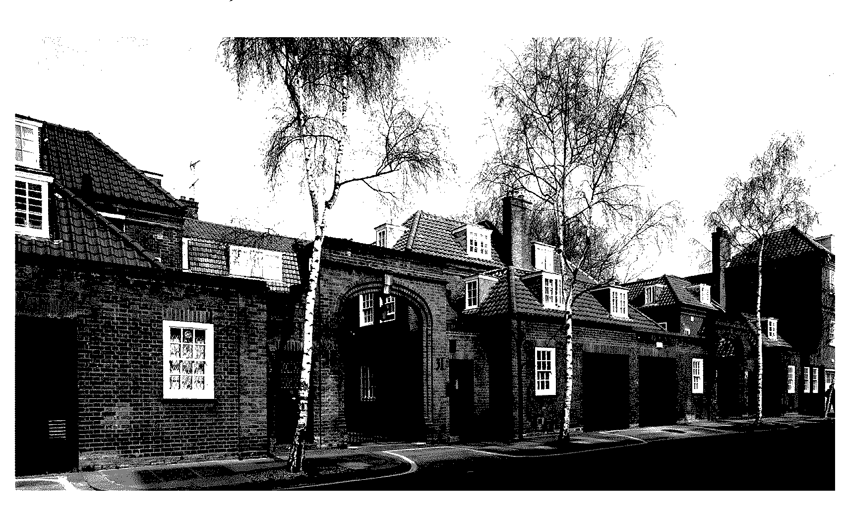
Houses and garages at the south end of Chelsea Square
Other Improvements
General improvements on a piecemeal scale continued to be carried out up to the Second World War. The borough council had widened the western end of King's Road up to Stanley bridge in 1908-9, important for local and through traffic, (fn. 75) and other improvements had gradually been made to King's Road since the beginning of the century, the building line set back and the road widened as leases fell in, especially west of Beaufort Street where the road made a sharp turn. The widening was accompanied by new building including the Chelsea Palace of Varieties between Beaufort Street and Chelsea Town Hall, but the widening was far from finished by the late 1920s. (fn. 76) On the north side houses between Cadogan and Anderson streets were rebuilt, and on the south side between Walpole Street and Royal Avenue the enormous 10-storeyed Whitelands House, a block of shops and flats, was completed in 1937. Further west near Chelsea Town Hall was Swan Court, another great block of flats with streamlined brick frontages to both Manor and Flood streets. (fn. 77)
The motor car was beginning to be an important factor in Chelsea's growth, as houses and flats were being built with garages or underground parking to meet the needs of middle-class residents. Attractive purpose-built garages and service stations also appeared, such as Carlyle Garages, no. 350 King's Road, originally called the Blue Bird Garage, designed by Robert Sharp in 1924 with capacity for 300 cars and segregated waiting rooms for chauffeurs, ladies, and owner-drivers, (fn. 78) which testifies to the growth of private motor transport and to the affluence of some Chelsea inhabitants. Smaller firms had showrooms and workshops, like Duff Morgan at the north end of Flood Street. (fn. 79) Other garages and petrol stations grew up on any vacant site, such as the razed streets of the Chelsea common area, left empty for some 25 years. (fn. 80)
Despite the amount of new private building in Chelsea in the 1930s, the outstanding examples of modernism were few. On the large site of Catharine Lodge and its grounds between Old Church Street and Trafalgar Square, divided into four, two houses fronting the square were built to neo-Regency designs by Oliver Hill, (fn. 81) but the two sites in Old Church Street received different treatment. No. 64, designed in 1935-6 by Erich Mendelsohn and Serge Chermayeff for the émigré publisher Denis Cohen, and no. 66, by Walter Gropius and Maxwell Fry for the playwright Benn Levy, brought Continental standards of modernism to a conservative neighbourhood, and despite their uncompromising appearance were generally well received. (fn. 82)
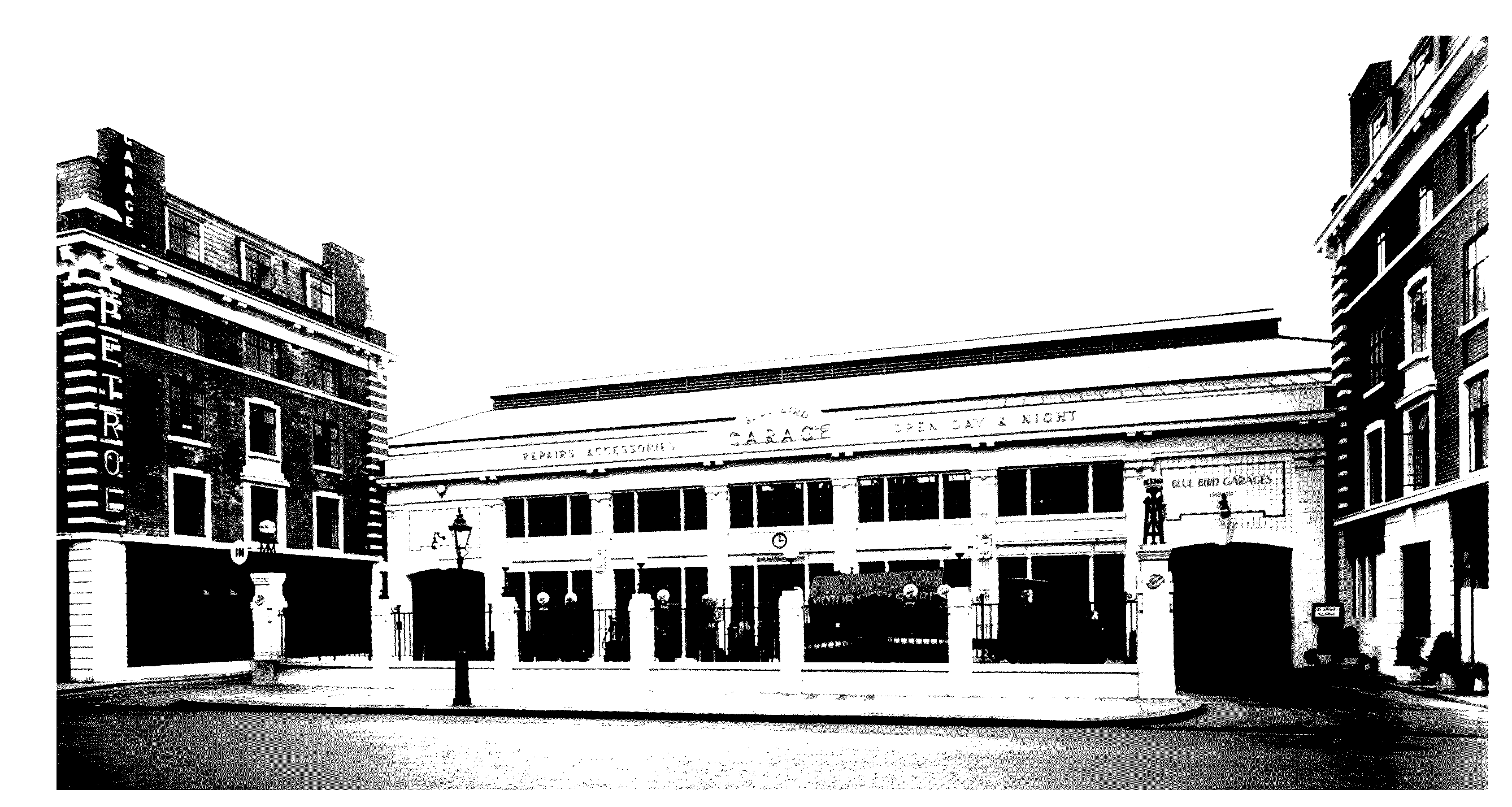
The Blue Bird Garage, no. 350 King's Road, in 1927
Sloane Street and Square
The borough council c. 1903 widened the north end of Sloane Street, a bottleneck where a third of the growing through traffic consisted of buses to other parts of the metropolis, (fn. 83) and the street underwent a transformation in the interwar years, being largely rebuilt after 1918 so that by the 1940s its northern end was altered almost out of recognition. On the east side a large annexe to Harvey Nichols' drapery store was built in 1923 at the Knightsbridge end, a 6-storeyed building faced with red brick and stone dressings. Next to it Richmond Court stretched nearly to Harriet Street, a towering block of shops and flats faced with yellow brick built in 1937-8, and behind it east of Harriet Mews were flats erected in Lowndes Square. The two buildings in Sloane Street replaced a long row of Georgian houses with high-class shops on the ground floor; by the 1940s only three of these remained, on the corner of Harriet Street, and between Harriet Street and Cadogan Place almost all the original houses had been replaced leaving only a few of the original buildings which once lined the east side of Sloane Street. (fn. 84)
Many buildings on the west side of Sloane Street had been erected not long before the First World War. Those built in the northern half between the world wars invariably combined flats or offices with ground floor shops and were reticent in design. They included Knightsbridge Court built 1926-7 to replace nos 9-16 Sloane Street, a 9-storeyed block faced with red brick, with the main entrance though a courtyard from Sloane Street and a second frontage onto Pavilion Road behind, a four-storeyed, stone-faced block at the north corner of Hans Crescent built in 1925, and beyond Hans Crescent and facing Cadogan Gardens another tall block built in 1935. At the south corner of Sloane and Pont streets stood the 19th-century Cadogan Hotel, enlarged by 1949. (fn. 85) Hugo House, built 1931 at nos 177-8 Sloane Street, provided 11 flats and 4 shops. (fn. 86)
Exclusively residential blocks were concentrated south of Pont Street among the remaining Holland houses, and included Dorchester Court, Cadogan House, and Sloane House, all facing Cadogan Place. While flats were popular, the older town houses such as those in Cadogan Square had remained empty for several years, but by the late 1940s were selling again and being renovated by new owners. (fn. 87) Cadogan Place also underwent changes. Some of the houses were divided into flats: no. 89, for example, was divided by 1928. (fn. 88) Chelsea House of 1874 at the corner of Lowndes Street and Cadogan Place was demolished in 1934 to make way for what is perhaps Chelsea's most stylish block of interwar flats and shops, designed by Thomas Tait, which made the junction into a local commercial focus. (fn. 89) By the 1940s the effect of the rebuilding since 1880 had transformed Sloane Street from a respectable commercial and residential street, bordered by the meaner streets of New, Exeter, and North streets, into a fashionable shopping centre which rivalled Bond Street, with opulent side streets in Basil Street and Hans Crescent. (fn. 90)

Chelsea House 1935, flats and shops built on the site of Lord Cadogan's Chelsea House
Sloane Square and the area to the south also saw further changes in the interwar years. In Sloane Square the crossroads was replaced in 1929 by a roundabout traffic system, making the centre of the square an island paved with flag-stones and planted with plane trees: in the 1930s it was often used as a meeting place by street orators. (fn. 91) On the west side of Sloane Square, the only side not rebuilt around the turn of the 20th century, the mid 19th-century buildings, one of which had been a public house, had become part of the Peter Jones department store. They were replaced 1935-7 when the whole shop was rebuilt with a 6-storeyed curtain wall of glass and steel, then unique in London, which was set back to King's Road to allow road widening. (fn. 92)
South of Sloane Square the 200-year-old Rose & Crown Tavern on corner of Lower Sloane Street and Turk's Row was pulled down and rebuilt in 1933 as a 5-storeyed block called Sloane Court, with flats above the tavern, (fn. 93) and in 1934 St Jude's church, opposite Sloane Court, was demolished and the site taken on a building lease for York House flats, designed by George Vernon. (fn. 94)
THE CHELSEA SOCIETY AND THE CONSERVATION MOVEMENT
Famous features of Chelsea, such as the grounds of the Royal Hospital, have always found vociferous public defence when they were threatened. When the temporary government buildings, which had been erected on Burton's Court in 1917 for the Ministry of Pensions, were still there and being increased early in 1919, blocking the view of Chelsea Hospital and destroying the playing field, many influential people protested about the threat to one of London's most beautiful and historic sites, and demanded that the government pledge to remove the buildings as soon as other accommodation was available. The campaign continued for several months, with approaches to leading government figures after the minister said that the buildings would remain for some years. (fn. 95) Lesser-known buildings and streetscapes, however, were constantly under threat, and without public pressure in their defence could disappear quite quickly.
In 1926 the imminent demolition of Lombard Terrace on the Sloane Stanley estate aroused local indignation, with a printed petition, and was commented on in the national press. This row of simple 3-storeyed 18th or early 19th century buildings with three or four old-fashioned shops, typical of its period, faced the river at the junction with Church Street, and was all that survived of Lombard Street after the creation of Chelsea Embankment, and almost all that remained of the old Chelsea riverside. One house incorporated the northern portion of the much older Arch House. (fn. 96) Chelsea residents petitioned against demolition but without success, and all disappeared but two, given temporary reprieve because the tenants were protected. (fn. 97) This and other losses in the recent past, with the threat to other parts of old Chelsea which had revived with renewed interest in redevelopment, led to the formation of the Chelsea Society in 1927, to protect and foster what were described as the amenities of Chelsea. It came into being at a meeting held at Wentworth House, Swan Walk, through the efforts of Reginald Blunt, who saw the need to co-ordinate local opinion before changes were forced through; the difficulties in saving buildings were exacerbated by the many residents whose stay in the area was only brief. The list of picturesque and historically important buildings already lost included Paradise Row, an 'exquisite old Queen Anne terrace', and the little old tavern opposite the Royal Hospital gates, Swift's lodging in Danvers Street, and Orange House in Cheyne Row. Local efforts had in the past saved the Physic Garden and Carlyle's house in Cheyne Row, but Blunt and the other founding members of the Society could see that the struggle to save other buildings and to resist schemes such as the westward embankment extension or building on the Duke of York's headquarters' site, (fn. 98) would continue relentlessly. They also thought it was important to ensure that any new buildings were good ones. (fn. 99) In June they held an exhibition in the Town Hall to make known their aims and purpose, exhibiting pictures of Chelsea from the late 18th and 19th centuries as well as photographs taken 1860-70 by J. Hedderley, (fn. 100) thus underlining the charm and character of Chelsea which they were seeking to preserve.
Thereafter the Society was a formidable watchdog where redevelopment was planned. Their annual reports and campaigns were always reported in the national press, (fn. 101) further galvanizing opposition to various threats. In the 1920 and 1930s they were concerned to keep the social mix of Chelsea and supported efforts to obtain better housing for working classes, such as at World's End. (fn. 102) From the 1970s on they fought even harder to prevent Chelsea becoming a rich ghetto. (fn. 103) The new society was quickly called into action when in 1927 the LCC wanted to demolish nos 16 and 18 Cheyne Row, the southernmost houses of the row of 1708 and still largely unaltered, to give a second access road to the land behind. Reginald Blunt wrote to The Times on behalf of Chelsea Society describing the houses and their history, (fn. 104) the works committee of the borough council voted to oppose the plan, (fn. 105) and eventually the houses were saved. The Society tried unsuccessfully in 1938 to prevent the demolition of the remaining two houses in Lombard Terrace, nos 64-5 Cheyne Walk, formerly a well-known artists' café. Change in legislation meant the tenants were no longer protected and had been given notice to quit by the owner, Major R.C.H. Sloane Stanley, who claimed he was bound by a verbal promise to demolish the houses when he could, to give a view of the river from no. 1 Petyt Place. The Chelsea Society, despairing at the attitude of an owner who thought the two unpretentious little Georgian houses were not worth preserving, sought the intervention of the LCC, but without success, because consent to develop the site had been given in 1926 in return for allowing widening of Old Church Street at the junction of Cheyne Walk, and the houses were not considered of sufficient architectural merit to warrant preservation. (fn. 106)
During the 1930s the Chelsea Society drew attention to the destruction of working-class housing and its replacement by monotonous blocks of middle-class flats. In 1936 the Society complained about the number of vast blocks of flats built the previous year, hoping that no more would be built as they meant the eviction of Chelsea's own working-class population who were replaced with less permanent residents, who contributed little to the communal and social life of the area. The high value of land in Chelsea meant that ordinary house building was not a commercial proposition. (fn. 107) In 1937 it was reported that under the Overcrowding Provisional Order there were an increasing number of evictions of old working-class inhabitants and replacement by others, and houses were about to be demolished in Burnsall, Blenheim, Britten and Cale streets, all working-class dwellings. Though the council expressed regret, it had no power to prevent their replacement by larger 3-storeyed houses and flats with garages for middle-class residents, and the Society suggested that the council should acquire sites for municipal dwellings. (fn. 108) The following year, however, while the rebuilding of Chelsea Square and its neighbourhood was being completed, work on yet another large block of flats, Nell Gwynne House, was beginning, and the Chelsea Society could only deplore the fact that the planning authority could not oppose an application for development on the grounds of the class built for, but only on construction and suitability. (fn. 109)