A History of the County of Oxford: Volume 12, Wootton Hundred (South) Including Woodstock. Originally published by Victoria County History, London, 1990.
This free content was digitised by double rekeying. All rights reserved.
'Woodstock: Development of the town', in A History of the County of Oxford: Volume 12, Wootton Hundred (South) Including Woodstock, (London, 1990) pp. 333-342. British History Online https://www.british-history.ac.uk/vch/oxon/vol12/pp333-342 [accessed 24 April 2024]
Development of the town
New Woodstock developed at a gate into the royal park. The town's curving west boundary perhaps represents the line of the 12th-century park wall but the straight south boundary implies the deliberate marking out of a site, probably confined on the north and east by the road, later Oxford Street, to the Old Woodstock river crossing. (fn. 90) The south boundary divided Woodstock from a wood called Hensgrove, acquired by the king from the Templars and taken into the park, perhaps when the town was founded. (fn. 91) The park gate at New Woodstock may not have pre-dated the town: passage from the gate to the royal palace remained difficult, requiring long causeways. (fn. 92) Park Street, running east from the park gate, may have been laid out only when New Woodstock was planned, and on its south side is the church, where a 12th-century doorway provides the earliest evidence of building in the town.
The town in the later Middle Ages probably covered less than 40 a.; its 19th-century extent (61 ½ a.) included meadows on the north not granted to the borough until the 15th century. (fn. 93) The original town was smaller, for there was growth in the 13th century and early 14th. In 1204 the town was farmed for only £4, which included market tolls and quitrents or 'landgable', small annual rents applied to the original building plots. (fn. 94) Quitrents rose from 36s. 5d. in 1230 to 43s. in the 1260s, c. 45s. in 1279, and over 52s. in 1310; (fn. 95) they were not recorded again until the later 15th century. The increase suggests an addition between 1230 and 1310 of 30 burgages to a town which earlier contained c. 70, assuming an average quitrent of 6d.
In 1279, (fn. 96) a century after the town's foundation, quitrents were paid for c. 140 houses in the borough, of which 76 were described as tenements or parts thereof, 30 as messuages, and 33 as cottages; there were also 19 'places', probably potential building plots, some described as vacant, some evidently subdivisions of tenements, 16 stalls, 2 selds, 2 forges or smithies, 3 ovens or kilns (furnum), 4 pigsties, and many crofts, curtilages, and gardens. The tenements were the larger plots or burgages, and their typical rent was in the range 4d. to 8d., although many had been divided and others carried higher rents. Rents of messuages were invariably 3d. or less, and of cottages usually 1d. or ½d. The survey of 1279 named 97 rent-payers, besides 15 tenants or occupiers who did not pay rents directly to the king; presumably many undertenants were omitted.
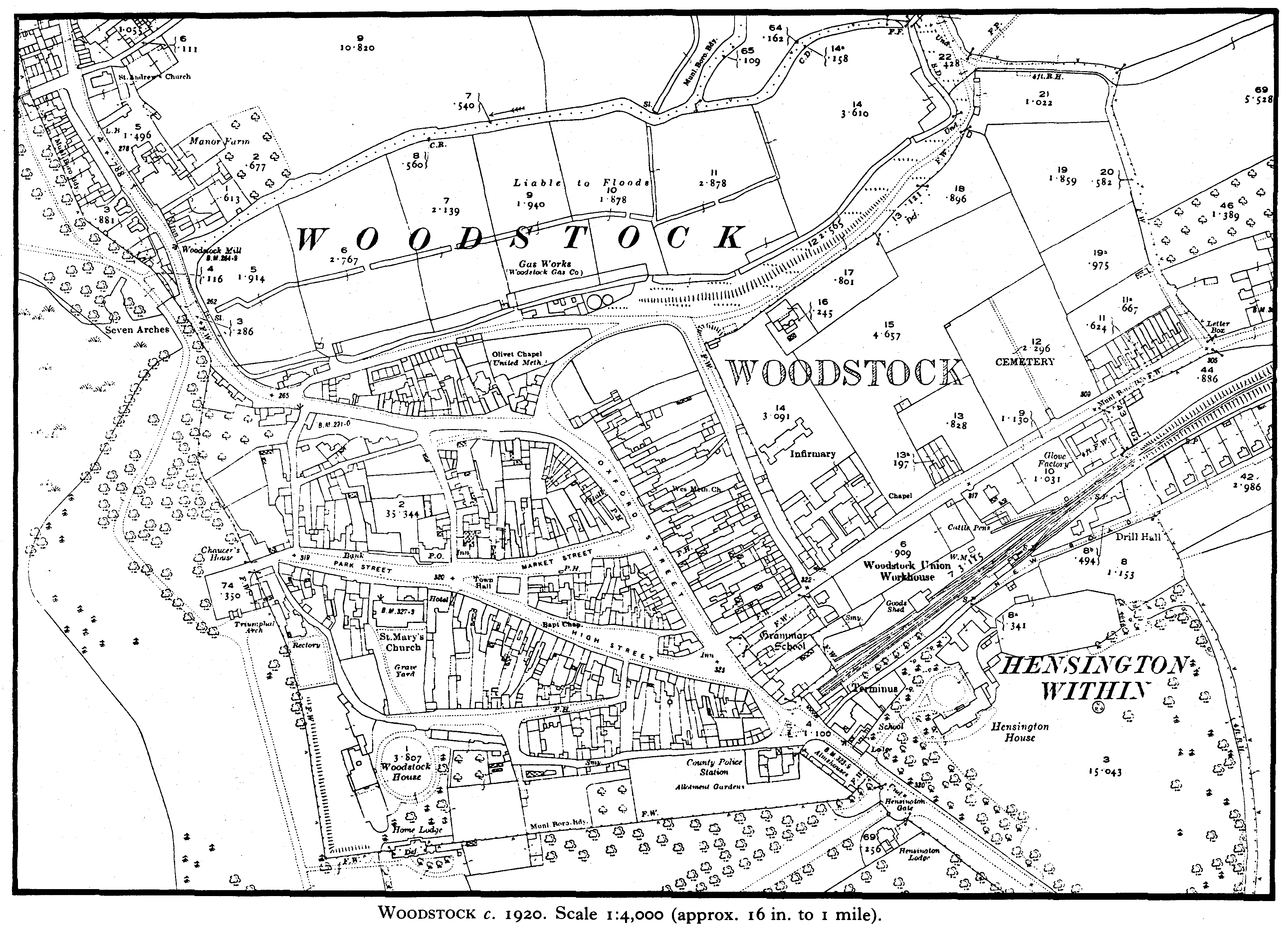
Woodstock
Woodstock c. 1920. Scale 1:4,000 (approx. 16 in. to 1 mile).
The survey was arranged topographically and, although street names were lacking, some sequences of rents may be assigned to particular streets. (fn. 97) Much of the later street plan was already established, with houses on Park Street, High Street, Market Street, and Oxford Street as far north as the point where it turns west. There was building, too, on the later Park Lane, Brown's Lane, Rectory Lane, and probably Chaucer's Lane, while the large island of buildings dividing Market Street from High Street had been established: references to houses there 'in the middle of the street' suggest that they were regarded as encroachments on what had been a triangular market place. On the south side of the town was the green, later usually called Back Green, where there had been substantial encroachment of cottages and crofts. At least one cottage was on the south side of the churchyard. On the north side of the church there were two houses and an oven or kiln. Then and until the 18th century the church was approached from Park Street by a narrow passage called the church stile leading to the north door, (fn. 98) and by a lane running past the west end into the churchyard and possibly continuing to the Back Green. In Market Place stood a stone cross, which survived in altered form until 1766, when demolished to make way for the present town hall. (fn. 99) John at Green's tenement 'against the stone cross' may be identified as the corner house, no. 2 Market Place, and traced by its quitrent of 1s. 6d. from 1279 until the 1930s, (fn. 1) when Woodstock's quitrents were finally compounded for. (fn. 2) Another tenement on the central island also carried the high quitrent of 1s. 6d. and probably both were large early encroachments. The town's medieval guild hall, not mentioned until the 15th century but perhaps already in use as a court house, also occupied the central island on the site of nos. 2-4 Market Street; (fn. 3) as elsewhere, the establishment of a free-standing court house may have begun the process of encroachment on the market place. (fn. 4) The 16 scabella (stalls or shambles), rented at 1d. each, were presumably permanent structures in contrast to other market stalls; probably all were for the sale of meat. Then as later the shambles were probably on the north side of Market Place. Houses flanked the park gate, probably a two storey, crenellated archway, which until the 18th century closed Park Street west of Rectory Lane on the line of the later borough boundary. (fn. 5)
The incidence of quitrents in 1279 and the implications of later plot shapes (fn. 6) indicate the town's early development. The broad Park Street, extending from the park gate and widening to form a market place, was presumably built first. Park Lane may once have formed the eastern limit as well as the 'back lane' of the earliest phase of development. The block further east on the south side of High Street was established before 1279; its western extension along the south side of Park Lane was built up later, since in 1279 a tenement on High Street not far west of Park Lane was bounded on the south by the green. (fn. 7) The north side of Park Street comprised long burgages stretching to Harrison's Lane, (fn. 8) a typical back lane, and throughout the Middle Ages the plots on the north side of Market Street extended to Oxford Street. (fn. 9)
In 1279 the burgages fronting Park Street, High Street, and Market Street carried very diverse rents, reflecting division, amalgamation, and encroachment during a century of development. By contrast Oxford Street rents preserved a regularity which implies more recent imposition. Plot shapes indicate that the street was built up later than Market Street and High Street: on the west side north of Market Street short plots abut the long plots of Market Street and have a curved frontage, presumably dictated by the line of an existing road bending towards the river crossing.
The straight frontage of Oxford Street's east side, however, ignored the line of the road and so created a wide market area. The long regular plots on the east side may be identified in the survey of 1279 as a sequence of tenements carrying mostly unaltered 6d. rents. The corner tenement of Joan the parker (fn. 10) began a block of 14 original tenements of which the last was described as a croft ad capud villae; only three had been divided. The fourth tenement from the corner carried a 7d. rent which may be traced to the site of no. 50 Oxford Street, (fn. 11) confirming that Joan's corner tenement lay at the north end near no. 60. The croft at the south end of the block was opposite houses which in 1302 occupied the corner of High Street and the Oxford road, (fn. 12) confirming that the croft lay near the present Hensington Road. Immediately north of the croft in 1279 was a divided tenement owing quitrents of 4 ½d. and 1 ½d.; the same rents were paid by nos. 14 and 16 Oxford Street in the 17th century. (fn. 13) Probably the croft lay just south of Hensington Road, where the convolutions of the later borough boundary suggest confusion or compromise after the built area was extended. (fn. 14)
Several tenements on the east side of Oxford Street retained 6d. rents in later times (fn. 15) and the whole block shows traces of the original burgages. The frontage is roughly a furlong; the 14 plots were presumably c. 3 perches wide and several later plots or pairs of plots were close to that width, notably the Marlborough Arms (52 ft. in the 18th century) (fn. 16) and some of its neighbours. The back lane on the east, later Union Street, was called Common Acre, (fn. 17) of which the east side formed the borough boundary. Before later encroachments it was unusually wide, almost a chain, and therefore comprised roughly an acre. (fn. 18) Taken together, the regularity of the rents, the form of the block and of Common Acre, and the continued uncertainty over the town's eastern boundary with Hensington (fn. 19) suggest that Oxford Street's east side was laid out not long before 1279 on one of Hensington's open-field furlongs, leaving the easternmost acre vacant as a back lane. The breadth of the street implies an intention to provide a new market area, perhaps following Henry III's grant of a fair in 1250. (fn. 20) Later in the Middle Ages a cross stood at its broad north end. (fn. 21)
A probable area of expansion after 1279 was the steep section of Oxford Street towards Old Woodstock, particularly the north side. (fn. 22) Continuing growth in the earlier 14th century, suggested by the town's acquisition of more fairs and a measure of urban independence, seems then to have halted, for by 1377 the population was much lower than in 1279. (fn. 23) In 1468-9 total quitrents of c. 46s. were payable for 89 houses, 21 cottages, 4 shops, 11 stalls, and various barns, crofts, closes, and encroachments, including properties in Old Woodstock excluded from the survey of 1279; rents for more houses, notably those of St. John's hospital, Oxford, were not listed individually but it seems certain that there were far fewer houses than in 1279. (fn. 24) In peripheral areas such as Back Green houses had been turned to barns, crofts, and gardens, and in the centre of the town a large plot at the corner of Brown's Lane and Market Place, later the site of Fletcher's House, was vacant. (fn. 25) Another indication of decay was the fate of St. John's hospital's Woodstock property, which passed c. 1453 to Magdalen College, Oxford; by then it was difficult to collect rents from holdings which had long been amalgamated or ruinous, and the college eventually secured only 6 a. in Old Woodstock and a cottage and close in Oxford Street. (fn. 26)
Although the town was granted murage in 1322 (fn. 27) there is no sign of fortification except for the park walls. There were bars at the town's entrances. Ale Bar gate on the Oxford road, recorded in 1504, was presumably the gate at the Town's End or Oxford gate referred to in the 17th century. (fn. 28) In the early 16th century there were bars on the east side of the town, (fn. 29) one probably on the present Hensington Road, another near the north end of Common Acre, barring the lane called Hensington Way or the way to Banbury. (fn. 30) In 1583 it was recalled that the townsmen had received Henry VIII at Castle Hill, (fn. 31) apparently at the north end of Common Acre. In 1436 a toft and croft at the north end of Oxford Street extended eastwards to 'Castle Wall', (fn. 32) and a street, possibly the later Upper Brook Hill, leading to the same feature was mentioned c. 1461; (fn. 33) there was apparently a small earthwork near the north end of Union Street in the 19th century. (fn. 34) The nature of the 'castle' is unknown: an adulterine castle said to have been built at Woodstock by the Empress Maud may have been merely a fortification of the king's houses in the park. (fn. 35)
By the 15th century the central streets were named. (fn. 36) Oxford Street and High Street were so called, the latter applying also to the later Park Street. Sections of High Street were defined by market names: Sheep Market or Sheepmarket Street seems to have applied to most of High Street east of Market Place, since it contained the sites of the later nos. 13-17 and 28 High Street and plots which stretched south to the green; (fn. 37) Corn Market or Cornmarket Street, sometimes called Cornmarket Hill in the 16th century, (fn. 38) was the later Market Place; the street west of Corn Market was Park Gate Street by the 17th century and Park Street by the 18th. (fn. 39) The 15th-century Wool Market or Woolmarket Street was the later Market Street. On the north side of Market Place were the shambles, a row of stalls ending on the west at Brown's Lane. (fn. 40) Other permanent market stalls lined High Street in 1468-9, and there were 'nether rows' of stalls in Market Place. (fn. 41) The island of buildings between Market Street and High Street was called Middle Row until the 17th century. (fn. 42) Probably much of Oxford Street was occupied by beast and horse markets mentioned later: a swine market mentioned in 1468-9 has not been located. (fn. 43) Horse Fair was at the southern entrance to the town in the 16th century, probably occupying the triangular green at the junction of Oxford Street and Rectory Lane: in 1583, when it was the subject of a boundary dispute, it was described as 'a place called Horse Fair between the town of Woodstock and the place of execution of felons'. (fn. 44) In the 19th century the triangular green was bisected by an undefined stretch of the municipal boundary. (fn. 45)
Brown's Lane was called Wappenham's Lane in the 15th century and, like Wappenham's Place mentioned in the 14th, may have been named from John of Wappenham, Woodstock's M.P. in 1305. (fn. 46) In the 16th century the lane was Crow Lane and by the 17th usually Blackhall Lane, from Black Hall, later the Star inn, at its corner. Its later name came from Alderman Thomas Brown (d. 1825), who lived at no. 2 from c. 1760. (fn. 47) Parker's Lane, mentioned in 1342, (fn. 48) was probably Park Lane, which from the 15th century until the 18th was called Pettyjohn's Lane from a medieval Woodstock family. (fn. 49) Houses on it were sometimes described as on Back Green, and the name Back Lane was sometimes used both for it and for it and for Rectory Lane until the surviving names were adopted before 1881. (fn. 50) The east part of Rectory Lane, unnamed in the 15th century, was usually described as the lane leading from the green towards Oxford but in 1504 was the street leading to Ale Bar gate. (fn. 51) It was Pest House Lane when the later no. 23 Rectory Lane was in use as a pest house between 1720 and 1765. (fn. 52) The medieval name Frog Lane was changed in the 19th century, first to Primrose Hill and later Harrison's Lane, from J. V. Harrison (d. 1854) of the White House. (fn. 53) Chaucer's Lane was probably 'the highway next to late Chaucer's place' in 1470. (fn. 54) The name Hoggerell Hill, usually Hoggrove Hill by the later 17th century, (fn. 55) applied generally to the slopes north of Harrison's Lane. Stodmare Lane mentioned in 1468-9, giving access to Stodmare or Stodengrove hill, (fn. 56) has not been identified. Stodengrove was probably the 16th-century Starting Grove in Hensington, immediately east of the later Union Street, (fn. 57) and Stodmare Lane perhaps the present Hensington Road or an alley, later blocked, on the east side of Oxford Street.
The part of Oxford Street descending steeply to the river was called Hollow Way by the early 16th century. (fn. 58) It was spanned at its junction with Brown's Lane by a 'great wooden bridge', maintained by the corporation. (fn. 59) The bridge may have been the 'new bridge leading to the king's mill' in 1479, near the Sibfords' house on the north side of Hollow Way. (fn. 60) It perhaps formed part of a direct descent from Brown's Lane to the corporation meadows through the site of no. 98 Oxford Street, which retains the appearance of later infilling. The bridge, which also spanned a watercourse running down Hollow Way, (fn. 61) was rebuilt in stone in 1748 (fn. 62) and presumably demolished c. 1780 when the road was levelled by the turnpike commissioners. (fn. 63) That section of Oxford Street was 'late a hollow way' in 1781 and was later sometimes called Pitching Hill or the Pitchings, (fn. 64) perhaps because of the stone embankment on the south side.
Changes in street names in the 16th century indicate a rearrangement of the market. In 1567 the east end of High Street, formerly the sheep market, was called Hogmarket Street, (fn. 65) but by the early 17th century the hog market was in Market Street between the wool market on the west and the beast market, (fn. 66) which occupied the east end of Market Street and extended north on Oxford Street. (fn. 67) The cattle and pig markets were still in Market Street in the 19th century. (fn. 68) The sheep market was moved from High Street to Oxford Street during the 16th century, occupying chiefly the section between Market Street and High Street. (fn. 69) Oxford Street north of Market Street, called Beast Market in 1675, was Cow Fair in later times. (fn. 70) By the 18th century and perhaps by the early 17th the horse market had expanded into the east end of High Street, (fn. 71) and in the 19th century High Street was called Horse Fair. (fn. 72)
The grouping of craftsmen within the market area was reflected in the names Copperyware Street and Coopery or Coppery Market, from the coopers' craft, applied to the north side of High Street; (fn. 73) opposite was the Glovers' and Shoemakers' Street. (fn. 74) The names, repeated in deeds into the 18th century, probably relate to much earlier arrangements. Fishmongers, like butchers, were closely regulated by the corporation, their stalls restricted under a bylaw of 1580 to the north side of Market Street. (fn. 75) Fellmongers were placed at that time in Market Place near the end of Brown's Lane, (fn. 76) to which the entry was probably much wider before a large encroachment was made on the west side c. 1600. (fn. 77) In the early 17th century the country bakers set out their wares around the High Cross in Market Place, which by then was a roofed structure; (fn. 78) vegetables, fruit, and oatmeal were also sold in Market Place in 1652 and there was a 'new bench' there for corn and cheese sellers in 1713. (fn. 79) The 'ancient market place for butchers' on the north side had been augmented by butchers' stalls on the south side by the later 17th century. (fn. 80)
The medieval streets probably drained into central gutters, which in 1622 were rebuilt in stone and varied in width from 1 yd. near the church to 4 ½ yd. in Market Place; the street surface was regularly spread with gravel. (fn. 81) In the central streets numerous trees which the corporation maintained and replanted (fn. 82) included in the early 17th century a great elm at the east end of High Street, and another, called Robin Hood's elm, at the east end of Market Street. (fn. 83) The corporation planted ashes and elms at Town's End, the Oxford entrance, and then and in the 18th century maintained benches around some of the great elms. (fn. 84) The stocks, pillory, cucking stool, and roofed cage were in the central streets, (fn. 85) and the corporation rebuilt a well in Oxford Street in 1631. (fn. 86) The town's archery butts were set up in Butt Close on the Back Green in 1569 and earlier in an adjacent close. (fn. 87) The common pound in the 17th century was at the top of Hollow Way on the north side. (fn. 88)
Buildings of a public nature, besides the guild hall and High Cross, (fn. 89) included a late 15thcentury almshouse, later the town clerk's house, in front of the church, the town's late 16thcentury wool barn behind the later Woodstock Arms, (fn. 90a) Penniless Bench in Market Place, mentioned in the early 17th century, and the grammar school of 1585, housed from c. 1600 in a room attached to the church. (fn. 91a) All were later demolished. The principal medieval inns were probably the George, the Bull, and the Crown. The George, later the Marlborough Arms, on Oxford Street was an inn by 1468. The Bull and the Crown, both prominent by the 15th century and fading in the late 17th century or early 18th, faced each other across Market Place, the Bull on the site of the National Westminster bank (no. 16) and probably several plots to the east, the Crown on the site of nos. 9-11 Market Place. (fn. 92a) All three inns probably had courtyards, their long, wide plots giving room for stabling. Each also acquired valuable meadow on the edge of the town: Crown close on Back Green was attached to the inn for centuries, (fn. 93a) and there were adjacent George and Bull meadows on the river Glyme. (fn. 94a)
Most of the town's medieval houses were probably timberframed. Reused details survive, notably lancet windows at the rear of no. 18 Market Place, but the only substantial medieval domestic building is the timberframed and jettied no. 6 Market Place; (fn. 95a) other early timber structures may survive behind later fronts. There is slight evidence of a resurgence of building after the decline of the later Middle Ages: in 1498 a shoemaker was allowed a large encroachment to extend his house into Market Place, implying some competition for space in the central area; (fn. 96a) in the 16th century many houses were fronted by small shops, notably a narrow tenement north of the church with three shops on its frontage, and an inn in Market Place incorporating several shops. (fn. 97a) Even so the corporation's policy in the 1560s of granting away most of its newly acquired chantry properties on condition that they were rebuilt (fn. 98a) suggests widespread decay, and much of the town was rebuilt in the 16th and 17th centuries.
The extent and nature of the rebuilding reflected modest prosperity but the number of houses and inns paying rents or quitrents to the corporation rose from c. 82 in 1598 to only c. 107 in 1684; (fn. 99a) although the full extent of subdivision or multiple occupation is not revealed by the rentals Woodstock remained a small town. In 1662 only 116 householders were assessed for tax, on 398 hearths distributed among 119 houses, 6 ovens, and 3 forges. (fn. 1a) Half the houses were small, containing 1 or 2 hearths, but nearly a quarter (27) were assessed on 5 or more, including a 12-hearth house, probably the later Fletcher's House. (fn. 2a) Many larger houses were inns, including the Bear, the Crown, later nos. 9-11 Market Place, and the Three Cups, later no 18 Market Place. The later Barclay's Bank site was probably occupied by a 9-hearth house, and No. 20 High Street, a largely unaltered 17th-century building, was assessed on 8 hearths.
Some peripheral areas which had decayed in the Middle Ages were rebuilt, notably the north side of Hollow Way, and the south side of Park Lane; there was no suburban expansion and in the early 18th century vacant areas close to the centre included the west side of Chaucer's Lane and the eastern section of Rectory Lane. (fn. 3a) Evidence of competition for space in the market area, such as tall, narrow frontages or the creation of alleys along the length of plots, is lacking in Woodstock. Some houses on large medieval sites, such as Chaucer's House at the park gate, retained their size and status into modern times. A former chantry property rebuilt on its broad medieval plot in 1569 seems to have occupied the whole frontage of nos. 7 and 9 Market Street until divided in the 18th century. Amalgamation of plots, encouraged by the decline of the later Middle Ages, allowed the creation of large mansions: one, of which the core survives as Cromwell House (no. 28 High Street), fronted High Street for some 250 ft. with grounds extending south to Rectory Lane; the site remained largely intact until the mid 18th century. Another 'great house', occupying three or more medieval burgage plots, was on the north side of Park Street, where Alderman Thomas Brown c. 1614 built the core of Fletcher's House. The broad, stone fronts of Nos. 2-8 Park Street, no. 20 High Street, and no. 7 Market Place, all built by leading townsmen, were typical of the period.
The predominant building materials were coursed rubble or squared limestone and stone slates, although the corporation was still thatching its almshouses in the early 17th century. (fn. 4a) Most houses are two-storeyed, often with large attic gables, notably no. 20 High Street which retains carved bargeboards. Many incorporate a type of elaborately carved wood lintel which, from its quality and its occurrence, reused, in several later houses, was thought to be spoil from the demolished royal palace; some lintels, however, appear to be in situ, notably at no. 50 Oxford Street, no. 2 Park Street, and no. 20 High Street, all built before the palace was slighted. Some 17th-century bay windows survive: at no. 9 Market Street the two-storeyed bay retains Ipswich pattern framing in the upper window. Part of a grander later 17th-century stone front survives at no. 28 High Street, with stone mullioned and transomed windows and a heavy dentil-moulded cornice.
The appearance of the central streets was altered by permitted encroachments, notably for the building c. 1600 of nos. 2-8 Park Street, projecting far beyond the established street line and probably narrowing the entrance to Brown's Lane, and for the building c. 1600 of a mercer's shop, projecting into Market Street on the site of the Feathers hotel. The island of buildings at the junction of High Street and Oxford Street, later the Crown inn, although perhaps medieval in origin, attained its full size during the 17th century. There were many small encroachments for pales, penthouses, bulks, porches, staircases, and signs. Rents for pales were usually for fenced areas in front of houses: the Plough inn on the site of nos. 30-32 Oxford Street was rebuilt c. 1600 with a projecting central porch flanked on each side by 'impaled ground'. (fn. 5a) The typical penthouse was a roofed, lean-to structure with open sides: one built in 1650 at no. 18 Market Place may be that depicted in a mid 18th-century drawing. (fn. 6a) Presumably penthouses were built to protect market wares, while bulks were perhaps unroofed stalls or shop boards. Staircase encroachments may have been projecting blocks, but in most instances were probably cellar steps. Rents for signs were for freestanding posts in the street, such as that at the Bear hotel, the successor of a sign put up in the later 17th century; (fn. 7a) there were similar signs outside two inns immediately east of the Bear in the 17th century, the King's Arms and the Crown. (fn. 8a)
During the 17th century much of the clutter of barns, crofts, hayricks, and dunghills on Back Green was absorbed into the sites of three major houses. Woodstock House seems to have evolved from a house built in the 1630s in a large close against the park wall. To the north was another large, probably late 17th-century, house, which was demolished in the early 19th century and its site taken into the grounds of Woodstock House. In 1686 the rectory house, later the Bishop's House, was built on the northwest corner of the green in a close formerly attached to a house fronting Park Street next to the park gate. The present form of the Back Green, represented by the wide section of Rectory Lane and dominated by the perimeter walls of Woodstock House, was not fully achieved until the 19th century, but the owners of Woodstock House steadily extended their grounds from the 17th century, chiefly by acquiring corporation leases. Houses built on and near Butt close on the northern edge of the green, from which the butts were removed in the mid 17th century, (fn. 9a) were acquired and replaced by the stable block of Woodstock House. Part of Butt close in the mid 17th century was Cockpit yard; in 1715 a large enclosed cockpit was built at the west end of the eastern section of Rectory Lane.
In 1713 Sir John Vanbrugh expressed a wish to improve the town to accord with 'what strangers may reasonably expect to find in a borough town, joining to so great a palace as Blenheim'. (fn. 10a) Political rather than aesthetic motives inspired the offer to pave the town at the duke of Marlborough's expense. (fn. 11a) Vanbrugh's plan to rebuild the guild hall at the same time came to nothing, (fn. 12a) but his street scheme, retaining a central channel with a 'gradual rise to the buildings on each side', was carried out under the supervision of Henry Joynes in 1713 and 1714 at a cost of nearly £500 in each year. (fn. 13a) The quality of the town's streets was frequently commended; (fn. 14a) their 'knobbly pitching', unpopular by 1838, (fn. 15a) and central gutters survived until the mid 19th century.
The town's public buildings were transformed during the 18th century, mostly at the expense of the Marlboroughs. The old guild hall, demolished in 1757, was replaced by a shambles or market house, built in 1766, and the high cross and Penniless Bench were demolished in 1766 to make way for the new town hall. (fn. 16a) The appearance of Park Street, much altered by the removal of the park gate from its west end in 1723, (fn. 17a) was further transformed in the 1780s by the demolition of houses to open up the north side of the church and the rebuilding of the church tower in Classical style. Other buildings of a public nature included a pest house of 1720 in Rectory Lane, a workhouse of 1778 on the north side of Oxford Street, and two ranges of almshouses built for the Marlboroughs in the 1790s, of which one survives as Caroline Court. (fn. 18a)
The town's prosperity in the 18th century is reflected in its surviving houses, of which large numbers were rebuilt or refronted between the early 18th century and c. 1830; the town's relative decline in the Victorian period accounts for the continued dominance of Georgian and Regency styles in its buildings. The number of houses increased mainly through subdivision, but there was some expansion through cottage building, notably in Rectory Lane and Union Street in the later 18th century, and in Brook Hill from the early 19th; Union Street began as the 'new road in the Common Acre' in 1770 and more cottages were built there c. 1810. (fn. 19a) While rentals show an increase in identifiable houses from c. 106 in 1733 to only c. 125 in 1829, the census enumerators found 214 separate dwellings in the town in 1801 and 258 by 1821, after which expansion ceased. (fn. 20a)
The presence of distinguished architects and builders in Woodstock in the early 18th century was reflected in several notable houses. (fn. 21a) The most clearly Vanbrughian in style are Hope House (no. 14 Oxford Street), built in 1708, and the early 18th-century additions to the Bishop's House (formerly the rectory house); less markedly Baroque are nos. 6-8 High Street, built c. 1710 as a single house. All three houses were allegedly built with stone taken illicitly from the Blenheim building works. (fn. 22a) Another building perhaps attributable to Blenheim craftsmen was the George (later the Marlborough Arms), which emerged as one of the town's two chief coaching inns; it was enlarged and rebuilt in the 1720s or 1730s by the innkeeper Gabriel Brown (d. 1739), a close relative of the Oxford mason William Townesend, who was then working at Blenheim. The other great coaching inn, the Bear, acquired its imposing mid 18th-century east range and carriage entrance when it was merged with the former King's Arms, one of the town's leading inns in the late 17th century.
In the 18th century Park Street became fashionable: there Edward Ryves, town clerk, built the house later Barclay's Bank in the 1740s and Henry North, town clerk, the house later no. 9 c. 1800. Chaucer's House was largely rebuilt in the 18th century and Fletcher's House was enlarged and refronted by Thomas Walker, town clerk and the duke's auditor, in 1795. Much of the south side of the street was rebuilt in the early 19th century, notably no. 7, which replaced a gabled 17th-century house in the 1820s. Elsewhere in the town notable buildings included Woodstock House (fn. 23a) and Hensington House, built in 1768 in large grounds on the eastern edge of the town for the use of the duke's auditors. (fn. 24a) The corner house and shops later no. 2 Market Place and no. 1 High Street were built by the steel jewellery manufacturer George Eldridge (d. 1764). Eldridge's range was clearly designed for commerce, as was no. 14 Market Street of c. 1800, built by the Bellinger family of carriers and corn factors with large associated outbuildings and an integral carriage entrance. Except for malthouses there were few industrial buildings, since steel manufacture and gloving, Woodstock's chief 18th-century industries, were on a scale small enough to be carried on in workshops and small warehouses behind manufacturers' houses. In the mid 19th century the former cockpit and the malthouse range behind Hope House were used for gloving, but purpose-built factories were not introduced until machine stitching became general in the later 19th century. (fn. 25a)
Most 18th-century houses were of local stone, many of two storeys with attics and steeply pitched, stone-slated roofs. By c. 1800 ashlar or plastered fronts were more common than coursed limestone or rubble, and houses were usually of three storeys with, as grey slates were introduced, roofs of shallower pitch. There is little sign that London pattern books influenced local builders: most fronts were plain with small dentil cornices, shallow plat bands, and little or no architrave to the windows which were often decorated with a single keystone projecting over the head. Brick was introduced in the later 18th century, not only for cottages and outbuildings but for a few larger houses, notably nos. 2-4 Harrison's Lane of c. 1780 and nos. 18-20 Park Street and no. 14 Market Street of c. 1800. Bay windows, usually paid for as encroachments, became widespread from the 1760s. (fn. 26a) Many small houses, some resulting from subdivision of larger properties, were given shallow segmental bays to the ground floor, presumably marking the change from the open shop-boards and penthouses of the 17th century to glazed shop widows. Two- and three-storeyed bays were added to fashionable houses from the later 18th century, notably Hope House and Cromwell House; Hill House (no. of 65 Oxford street) designed with three-storeyed canted bays, is of the 1790s. (fn. 27a) Many Woodstock houses have flat door-hoods supported by stone or wrought iron brackets probably of the early 19th century, but there are earlier hoods, notably at no. 10 Oxford Street and no. 28 High Street, the latter removed from the Marlborough Arms.
There were usually c. 15 inns and public houses in the town in the late 18th century and 19th. (fn. 28a) Besides the Bear and the Marlborough Arms the coaching inns included the Angel, later the Old Angel, on the site of the former Bull (no. 16 Market Place), and the White Lion, later the Star, in Market Place. Other longlived inns included the surviving Woodstock Arms, King's Arms, Crown, and King's Head, all established under those signs from the 18th century; No. 8 Oxford Street was the New Angel from the mid 18th century until 1870s and nos. 3-5 Market Street (Blandford Court) were the site of an inn called the Star by the early 18th century, later the Blandford Arms until the First World War. From the late 18th century until the early 20th no. 38 Oxford Street was the Adam and Eve and no. 122 Oxford Street the White Hart. Movement of inn signs was common in Woodstock, and from the 16th century there were at least three successive King's Arms, Crowns, and Angels, and two White Harts, King's Heads, Stars, and Adam and Eves. Some houses changed signs several times, notably no. 11 High Street and no. 12 Oxford Street.
Nineteenth-century public buildings included the large union workhouse in Hensington Road, (fn. 29a) several nonconformist chapels, schools, a public station, and a railway station. The streets were repaved in the 1850s, and it was probably then that acquired lateral gutters and pavements; they were lighted by gas from a gasworks built on Brook Hill in 1853. (fn. 30a) In the later 19th century a few houses in the centre were rebuilt, some of them in brick, notably nos. 2-4 Market Street, replacing the shambles or market house in 1870, a pair of villas, nos. 27-29 High Street, the tall terraced row of shops and houses, nos. 23-29 Oxford Street, in the 1870s, and nos. 51-7 Oxford Street in the 1880s. Woodstock and relatively few of the cottage rows common in more populous 19th-century towns, but a group in the churchyard was demolished c. 1870, (fn. 31a) and in the 1880s cottages on Brook Hill and Hoggrove Hill were condemned and demolished. (fn. 32a) Another cottage row was removed when the surviving Methodist chapel was built on the east side of Oxford Street in 1907, (fn. 33a) and several cottages on Park Lane and Rectory Lane were demolished during slum clearances of the 1930s. (fn. 34a)
From the late 19th century, presumably because of the newly established railway link, the duke of Marlborough considered schemes for suburban development in Hensington, including c. 1913 a proposal to demolish Hensington House and build houses around a central area of croquet lawns and tennis courts. (fn. 35a) Hensington House was demolished in the 1920s but the site was not developed until the 1950s. The chief additions to the town in the late 19th century and early 20th (fn. 36a) were a few houses at the south end of Union Street and along Hensington Road, some of the latter built by the duke and sold to members of the Oxford Co-operative Society under a joint scheme. (fn. 37a) Pullman's glove factory was built c. 1890 on the south side of Hensington Road (fn. 38a) and New Road in Hensington was laid out and partly built up before 1922. A drill hall on its north side was bought by the corporation for a community centre in 1970; (fn. 39a) Crutch's glove factory on its south side was built c. 1924 and closed in the 1950s.
By the 1930s scarcity of building land obliged the council to acquire sites outside the borough. (fn. 40a) Between the two World Wars building was mostly in Hensington, and included council houses on Bear Close in 1932, and houses at the east end of Hensington, on Banbury Road and Shipton Road; Hill Rise at the north end of Old Woodstock was laid out, and a few houses were built on the Oxford road. A roman Catholic church was built on Hensington Road in 1934. (fn. 41a) A school was built on the site of Marlborough School in 1940 and a primary school on Shipton Road in 1968. (fn. 42a) After the Second World War Hensington continued to be built up; in the 1950 houses were added in the Green Lane area, on the Klondike on Shipton Road, and the Cadogan estate on the site of Hensington house; (fn. 43a) in the 1960s the large Hensington Gate estate was begun. Other areas of expansion included Cockpit Close on the southern edge of the town in the 1950s and Barn Piece Farm estate in Old Woodstock in the 1960s. By 1967 there were 150 council houses and 50 apartments in the builtup area. (fn. 44a) The former union workhouse was demolished in 1969 and the site used later for a home for the aged, Spencer Court, and a fire station, police station, library, and car park. Houses were built on the gas works site in 1972, (fn. 45a) in the Brook Hill area (partly on the corporation meadows) in the 1970s and 1980s, and along Hensington Road in the 1680s.
The central area changed little in the 20th century except for the renewal of shop fronts. Early in the century Lorimer's shop (no. 22 High Street) was built on a long vacant, and in the 1960s Blanford Court in Market Street replaced the former Blandford Arms; a tall block of apartments built in Oxford Street in the 1960s commands the northern approach to the town. The trees lining Oxford Street, planted at the duke of Marlborough's expense in 1885, (fn. 46a) fell victim to road-widening as the street became a major traffic route. From the 1920s until the 1950s the central streets were dominated by overhead electricity cables carried on large pylons. (fn. 47a) In 1975 Woodstock was designated as a conversation area.