A History of the County of Oxford: Volume 13, Bampton Hundred (Part One). Originally published by Victoria County History, London, 1996.
This free content was digitised by double rekeying. All rights reserved.
'Ducklington: Introduction', in A History of the County of Oxford: Volume 13, Bampton Hundred (Part One), (London, 1996) pp. 110-118. British History Online https://www.british-history.ac.uk/vch/oxon/vol13/pp110-118 [accessed 19 April 2024]
DUCKLINGTON
DUCKLINGTON lies on the west bank of the river Windrush immediately south of Witney and 5 miles north-east of Bampton. (fn. 1) It was a predominantly rural parish until the later 20th century when, as Witney spread southwards, Ducklington village acquired suburban features. In 1876 the ancient parish, which included Hardwick township, comprised 2,261 a. of which 1,941 a. lay in Ducklington township and 671 a. in Hardwick. (fn. 2) After transfers to and from the parish in 1886 under the Divided Parishes Acts Ducklington was reduced to 1,934 a. and Hardwick, by then a civil parish, to 442 a., the principal change being the transfer from Hardwick to Standlake of a large detached portion (241 a.) lying between Yelford and Cokethorpe Park. (fn. 3) In 1932 Ducklington was enlarged to 3,075 a. by the addition of most of Cogges (1,082 a.) and parts of Curbridge and Shilton; at the same time Ducklington lost 39 a. on the north to Witney and 202 a. on the south to the newly created parish of Hardwick-with-Yelford. The latter comprised 1,624 a., made up of most of the former Hardwick parish (440 a.), the whole of Yelford (336 a.), and 848 a. of Ducklington and Standlake, including the whole of Cokethorpe Park. (fn. 4) In 1967 Ducklington was reduced to 1,940 a. (785 ha.) by the transfer of 459 ha. east of the river Windrush to South Leigh. In 1985 a minor boundary change on the north enlarged Ducklington to 791 ha. Hardwick-with-Yelford remained unchanged at 657 ha. (fn. 5) This article treats the history of the ancient parish, and also of that part of Cokethorpe which until 1932 belonged to Standlake.
The 19th-century boundaries of Ducklington parish (excluding Hardwick) were largely those of an estate granted in 958 by King Edgar to his 'minister' Earnulf from land which belonged earlier to the large royal estate centred on Bampton. The grant was of 14 hides at Ducklington, together with the 'old church at East Lea' and its 40 a., and also Byrnan lea, presumably the site of the later Barley Park. (fn. 6) The east boundary of the estate, as of the 19th-century parish, followed the river Windrush southwards from Ducklington village, (fn. 7) its deviation from one branch of the river to another presumably reflecting the apportionment of valuable river meadows between various estates. On Standlake brook ¾ mile east of Hardwick the boundary reached another branch of the Windrush, since dried up, (fn. 8) where it turned sharply upstream towards and probably past Hardwick. At an 'old ford' the estate boundary left the Windrush to follow a stream one furlong south of a church. The stream was presumably the small watercourse on the boundary of Cokethorpe Park just south of Cokethorpe chapel, which was evidently the 'old church of East Lea'. The surviving channelled watercourse may earlier have meandered along the edge of the gravel terrace to the north end of Berryham plantation where a ford, the site of a Romano-British causeway, (fn. 9) may have been the 'old ford' of 958.
Beyond Cokethorpe chapel the Anglo-Saxon boundary continued along the stream, then uphill through a haga (? game enclosure) to a burh (? camp) ditch. The last was probably on the south-western edge of Home wood, where a notably straight perimeter ditch respects a rectangular moated earthwork of unknown date; (fn. 10) even if the earthwork postdates the charter the perimeter ditch itself may mark the site of the burh ditch, since there was much early settlement in the fields immediately adjacent. (fn. 11) The haga was probably a wooded enclosure, perhaps a royal park: although divided by the boundary of 958 it seems to have retained or recovered its integrity, since later a large area west of Cokethorpe chapel, including woodland north of the boundary of 958, and assarted woodland (the Breaches) south of that boundary, became part of Standlake manor and parish. (fn. 12) The transfer of its northern part from the Ducklington estate presumably occurred before parish boundaries were firmly established, perhaps before 1066.
The Saxon estate boundary seems to have continued along the south-western edge of Home wood and the southern edge of Boys wood. The 'old rode' of 958 may have been where the perimeter ditch of Home wood turns sharply westwards, 'Scot's hollow' the declivity occupied by the Long Train, and 'Wenburh's bridge' where the stream on the edge of Boys wood turns south to Yelford. From the south-west corner of Boys wood the boundaries of Saxon estate and later parish once more coincided, running south-westwards past Claywell down a ditch which in 958 led to the boundary of the 'men of Aston'. The zig-zag parish boundary north-west of its junction with Aston near Claywell farm survives from the estate boundary of 958, which in that section evidently picked its way round arable strips before reaching 'the brook of Aegel's spring', now Elm Bank ditch on Ducklington's west boundary. The west and north boundaries of the Saxon estate and later parish followed Elm Bank ditch to a 'stone ford', identified west of Coursehill Farm where Ducklington's boundary meets those of Lew and Curbridge; (fn. 13) the 'fugel' (bird) slade was probably the narrow valley where the parish boundary turns sharply north-east, passing to Colwell brook, so named in 958, which formed the parish boundary as far as Emma's bridge in the north-east. (fn. 14) Thence the estate and parish boundaries followed a watercourse (hastinges lace), which was evidently straightened in later times, (fn. 15) to rejoin the Windrush near Ducklington village.
After the removal from Ducklington of the suggested early park the southern parish boundary with Standlake followed the north-west edge of Boys wood. Its medieval line south-eastwards through the later Cokethorpe Park is uncertain: assarted closes mostly on the west side of the park, including the site of Cokethorpe House, were in Standlake, but the chapel and much of the east side of the later park remained in Ducklington. (fn. 16) Because Cokethorpe chapel served Hardwick that township also became part of Ducklington, despite prolonged insistence by Bampton parish on certain parochial rights. (fn. 17)
Ducklington c. 1838
The boundaries within Cokethorpe Park were simplified at or before the inclosure of Ducklington in 1839 when a straight line running north
from Cokethorpe House became the boundary between Standlake on the west and Ducklington, and a straight line running east from the house and north of the chapel divided Ducklington from Hardwick. (fn. 18) Hardwick's boundaries elsewhere were largely undefined until inclosure, since its fields were intermixed with those of Standlake and came to include some of Yelford's open fields. (fn. 19) Certainly the township was bounded on the east by the Windrush and on part of the west by the inclosed Breaches, and included Hardwick field, and Hardwick common where the inhabitants had their principal holdings. (fn. 20) When Hardwick was inclosed and its tithes apportioned in 1852-3 its boundaries were redefined to include c. 425 a. around the village and a large detached area near Yelford. (fn. 21) Those boundaries were mostly obliterated after the changes of 1886 and the creation of Hardwickwith-Yelford parish in 1932. (fn. 22)
In the peripheral river valleys the land is low-lying (c. 75 m.) but a ridge of higher ground extends from Coursehill Farm in the north-west to Cokethorpe Park in the south-east, its highest point being 96 m. near the centre of the parish. Alluvium overlies flood plain gravel in the river valleys, and gravel extends westwards from the river Windrush beneath the villages of Ducklington and Hardwick, into Cokethorpe Park, including the sites of chapel and house, and, further south, across much of the former Hardwick field towards the Breaches. There are islands of deposited gravel on higher ground, notably around Barley Park Farm and Home Farm, Cokethorpe. The rest of the parish lies on Oxford Clay. (fn. 23)
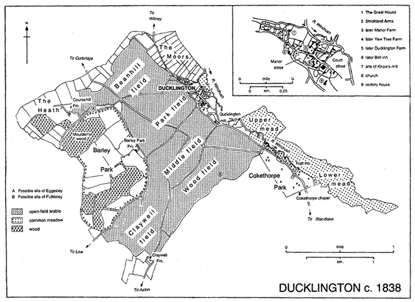
Several Anglo-Saxon settlement names within the later parish incorporate lea(h), (fn. 24) their location suggesting that much of the higher ground was wooded. Large stretches of woodland survive, (fn. 25) partly perhaps because of medieval and later imparkment. Barley Park in the northwest of the parish was created or enlarged in the mid 13th century, and was an enclosed deer park of some 375 a. in the 16th century and possibly later. (fn. 26) The creation of Cokethorpe Park (c. 310 a.) in the 18th century increased the wooded area, although its principal woodland lay in Standlake parish. (fn. 27) Before the inclosure of Ducklington's open fields in 1839 the alluvium in the valleys was largely reserved for meadow and pasture, the arable fields stretching westwards from the village to Barley Park and southwards between the park and Boys wood to Claywell. (fn. 28)
The principal road through the parish was the north-south route from Witney through the village, past Hardwick, to Standlake and a crossing of the river Thames at Newbridge: it formed part of the London-Gloucester road. (fn. 29) A bypass west of Ducklington village was built in 1974-5. A road from Hardwick across Hardwick common to Standlake was laid out at the inclosure of Standlake in 1853; (fn. 30) its heavy usage for gravel transport led to the provision of a bypass south of Hardwick in 1974-5. Minor roads (fn. 31) linking Ducklington to Curbridge and Aston were altered and confirmed at the inclosure of Ducklington in 1839. The Aston road earlier followed a more easterly line down the valley to Claywell. The lane from Hardwick to Yelford was realigned further south at the inclosure of Standlake. Before 1839 a road called Broadway branching from the Ducklington-Standlake road west of Ducklington mill ran north-westwards to the junction of the Curbridge road and the track to Coursehill Farm. That track probably survives from an early road, in part called Greenway, running from the 'stone ford' of 958 on Ducklington's west boundary past Coursehill Farm, near the site of a deserted medieval settlement, Eggesley. (fn. 32) Another east-west route, confirmed in part as Lew footway in 1839, ran westward past Barley Park Farm to Lew. Further south a probably more substantial road known as Lew way, confirmed in part in 1839, crossed from Lew into Ducklington south-west of Barley Park wood, following the ancient park pale north-eastwards; from it there may have been a branch eastwards to meet the former Claywell-Ducklington road on the high ground north of Boys wood, whence a lane, partly surviving, crossed the open fields to Ducklington mill. That suggested route may have been the 'highway' running eastwards from 'Barley ditch' across Ducklington to the Windrush which was alleged in 1318 to be Bampton's north-east boundary: although the road was probably never an ancient boundary it conveniently divided Ducklington from Cokethorpe and Hardwick, over which Bampton church had stronger claims. (fn. 33)
In the mid 19th century there was a regular carrying service to Witney, Oxford, and Abingdon. (fn. 34) The nearest railway station was at Faringdon (Berks.) from 1840, until Witney and South Leigh stations were opened in 1861. (fn. 35) Ducklington had a short-lived post office in 1861; another was opened in 1888, attached at first to a grocer's shop in the house later Church Farm, and by the early 20th century established in the Square. (fn. 36)
There are indications of Bronze Age occupation west of Ducklington village and south of Cokethorpe Park. (fn. 37) South-east of Hardwick was a small middle Iron-Age settlement, protected by a circular double ditch; it was largely pastoral and perhaps occupied only seasonally. (fn. 38) A small late Iron-Age settlement was found on the line of Hardwick's bypass, (fn. 39) and there are cropmark indications of other probable prehistoric sites, notably just west of Ducklington, north of Boys wood, and west of Hardwick. (fn. 40) A RomanoBritish settlement including slated and tiled structures was found on the line of the bypass south-west of Ducklington; it was occupied between the 2nd and 4th centuries. (fn. 41) Of similar date was an apparently linear settlement beside a Roman or Romanized road which, partly on a wooden causeway, crossed branches of the river Windrush between Gill Mill (now in South Leigh) and Berryham plantation north-west of Hardwick. (fn. 42) The settlement straddled the later parish boundary, extending on both sides of Standlake brook. Votive reliefs found on and near the site may indicate a temple. (fn. 43) South-west of the Windrush crossing the Roman road presumably passed close to Cokethorpe chapel. (fn. 44)
Two graves, probably 7th-century, one clearly Christian with notably rich goods, were found in 1860 in Wormwood close, north of Church Street in Ducklington. (fn. 45) The graves were probably in a large burial ground, since many skeletons were reportedly found in a garden on the east, now attached to Windrush Cottage. (fn. 46) Isolated 7th-century graves with rich goods were found south-east of Ducklington near Red Lodge, (fn. 47) and on the south-east boundary of Cokethorpe Park. (fn. 48) The Ducklington finds, together with those in a large burial ground just outside the later parish boundary towards Yelford, (fn. 49) suggest substantial, and fairly prosperous, Anglo-Saxon presence in the area by the 7th century.
By then Ducklington (? Ducel's tun) (fn. 50) may have been settled, and in 958 was evidently a nucleated village, possibly with a church. (fn. 51) The large estate centred on Ducklington contained several other settlements and a very early church. The 'old church of East Lea', though standing in or near the probably minor Saxon settlement of Cokethorpe (? Cocca's throp), (fn. 52) continued to be regarded as the church of East Lea rather than of Cokethorpe until the early 13th century. (fn. 53) East Lea may not have been a single settlement but a larger area, perhaps so named because it was a clearing on the east of the belt of woodland which partly survives as Home and Boys woods; in the early 13th century woodland there, belonging to Standlake manor, was referred to as the 'wood of East Lea'. (fn. 54) Cokethorpe chapel's antiquity and its location in a small hamlet suggest that its origins may have been associated with the conversion of a pagan area rather than the service of an established Christian community; the chapel's proximity to a reputed holy well, its location on or near a Roman or earlier road, and its probable original dedication to St. Michael support the possibility that it replaced an existing shrine. (fn. 55)
Other Anglo-Saxon settlements within the ancient parish seem to have been associated with woodland clearance. Eggesley in the north-west and Putlesley or Puttesley probably near the centre of the parish were small hamlets in the early Middle Ages, their names perhaps combining personal names with lea. (fn. 56) There may also have been early settlement at Byrnan lea (? Beorna's lea, later Barley) in the west, mentioned in 958. (fn. 57) Claywell was a hamlet in the south-west of the parish, surviving as Claywell Farm. (fn. 58) In 1086 it was Welde and later Weald, denoting woodland or cleared woodland, and was frequently East Weald in distinction to Weald in Bampton; (fn. 59) the form Clayweld, in use by the 15th century, (fn. 60) corrupted to Claywell. Hardwick in the south-east of the parish was not part of the Ducklington estate of 958. (fn. 61) Its name (heordewic), combining 'herd' with an element usually denoting a small farm, (fn. 62) suggests that it was in origin a subsidiary pastoral settlement, perhaps of Brighthampton (in Standlake) with which it was later linked tenurially. (fn. 63)
In 1086 there were c. 50 recorded tenants on the manors of Ducklington, Claywell, and Hardwick (fn. 64) and in 1279 over 75 named tenants on those manors, not necessarily all resident. (fn. 65) In 1306 there were 66 taxpayers in Ducklington and its hamlets, and in 1327 a similar number (57 in Ducklington and Claywell, probably fewer than 20 in Hardwick). (fn. 66) After mid 14th-century plagues the population may have been greatly reduced: in 1377 only 103 persons over 14 were assessed for poll tax, a figure which probably excluded Hardwick, (fn. 67) and in the later Middle Ages several minor settlements were deserted. In 1523-4 only 11 in Ducklington and 5 in Hardwick paid subsidy, and the highest numbers assessed for 16th-century subsidies were 20 and 8 respectively in 1542-4; (fn. 68) a few other Ducklington parishioners continued to live in Cokethorpe, discussed below.
From the later 16th century baptisms consistently outnumbered burials, a rise in the period 1600-40 from roughly 9 baptisms and 4 burials a year to 13 and 7 respectively indicating rapid population growth. (fn. 69) In 1641 the Protestation oath was sworn by 150 men and women in Ducklington, 73 in Hardwick. (fn. 70) The 51 houses assessed for hearth tax in Ducklington in 1662 included one in Claywell and some in Cokethorpe, while in Hardwick fewer than a dozen houses and 25 hearths were assessed. (fn. 71) In the 1690s, the 1730s, and the 1790s there were roughly 13 baptisms and 9 burials a year, and in 1801 there were 101 families in 82 houses, and the population was 442, including 121 in Hardwick. (fn. 72) Numbers increased steadily to a peak in 1871 of 629 (including 149 in Hardwick), falling to 540 in 1891 and 486 (97 in Hardwick) in 1931. (fn. 73) Thereafter the population of the newly created Hardwick-with-Yelford was fairly stable, falling to 85 in 1961 and rising to 112 in 1991. (fn. 74) Ducklington's population of 549 in 1951 and 740 in 1961 included the villages of Cogges and South Leigh. The transformation of Ducklington village into a dormitory suburb, chiefly from the 1960s, was evident in 1971 when, with reduced boundaries comparable to those of 1931, the parish had a population of 1,274 in 405 households, a rise from 104 households in 1931. Growth slowed thereafter, and in 1991 the population was 1,437. (fn. 75)
At Eggesley in 1279 there were 9 tenants of Ducklington manor, each with a house and half yardland. (fn. 76) Some are identifiable among Ducklington taxpayers in the early 14th century, (fn. 77) but no later reference to the hamlet is known. Its probable site was between Coursehill Farm and Moulden's wood (called Edgeley coppice in the 17th century and later), (fn. 78) where two adjacent fields, one called Edgerley ground in 1839, (fn. 79) retain signs of house platforms and have yielded early medieval pottery. (fn. 80) At least one ancient road seems to have served the settlement. (fn. 81) There may have been a related but distinct settlement at Coursehill: men 'of Coursehill' were recorded c. 1200 and in the early 14th century, (fn. 82) and a holding there belonged to Eynsham abbey in 1335. (fn. 83) By the later 15th century the same holding, evidently deserted, was 'a meadow below Ducklington'. (fn. 84)
At Putlesley in 1279 there were 3 tenants of Ducklington manor, and Eynsham abbey held a yardland there in demesne. (fn. 85) Tenants may be identified among early 14th-century Ducklington taxpayers, and a decayed holding once Robert Puttesley's was mentioned in 1430. (fn. 86) The hamlet's name may have been preserved in Pitchless hill, applied in the early 19th century to the high ground north-west of Boys wood; (fn. 87) a possible settlement site there has been suggested, on the gravel immediately north-west of Home Farm, which lacks the ridge and furrow covering most of Pitchless hill. (fn. 88)
Claywell was a much more substantial settlement whose desertion in the later Middle Ages, though apparently gradual, may have begun with a serious onslaught of plague, since Yelford, a mile to the south-east, was largely abandoned in the same period. (fn. 89) In 1086 there were 10 tenants on Theoderic's Claywell manor, some probably at Aston; in addition there were presumably several Claywell tenants of Ducklington manor. (fn. 90) In 1279 there were 9 such tenants, and 6 or 7 others holding of Theoderic's successor, the abbot of Eynsham. (fn. 91) In 1306 and 1316 there were c. 14 and 17 taxpayers at Claywell, and an apparently similar number in 1327 when Claywell was assessed with Ducklington. (fn. 92) In c. 1360 Eynsham abbey retained 6 Claywell holdings whose rents were sharply reduced between 1403 (fn. 93) and the 1420s, when much was in hand. (fn. 94) Whether the late 14th-century tenants lived at Claywell is uncertain, but it may be significant that 'fishsilver', apparently payable by all the abbey's Claywell tenants, was more than 25 years in arrears by 14O7. (fn. 95) In 1430 Ducklington manor's holdings at Claywell were let at only half their earlier rent because of decays and shortage of tenants. (fn. 96) Later in the 15th century the abbey's estate was let at will to one tenant; (fn. 97) he may have sublet to several others, but from the 16th century the estate, usually described as Claywell farm, seems to have been a single holding. (fn. 98) Ducklington manor's land in Claywell was presumably worked from Ducklington.
Claywell lay at the foot of a narrow valley two miles south of Ducklington, to which it was linked directly by the Lew-Ducklington road, rerouted further west at inclosure. (fn. 99) Another road, mentioned in 1306, ran from Claywell through or beside Yelford's open fields towards a wood, unidentified, called Weldehamho. (fn. 100) Claywell may have had a chapel, since the post-medieval tenants of Claywell Farm paid rent to Ducklington church, allegedly for a former churchyard. (fn. 101) The descent of Claywell Farm suggests that it occupies land formerly part of Eynsham abbey's estate, possibly a manorial site. (fn. 102) Two closes south and south-east of the house, however, belonged before inclosure in 1839 to Walter Strickland of Cokethorpe, who had acquired much of the land attached to Ducklington manor; (fn. 103) they may have contained medieval tenements of that manor. Earthworks indicating former buildings are particularly marked in a close west of the house. (fn. 104) That close and the site of the farm buildings south of the house were Upper and Lower Paddock in 1839, and the alleged churchyard was said to be in 'the Paddock'. (fn. 105) A ditch east of the farm buildings marks the line of the former Lew-Ducklington road. (fn. 106)
Cokethorpe, which had only three or four recorded houses in 1279, (fn. 107) remained a small hamlet until reduced in the 18th century to an isolated chapel in the newly created park around Cokethorpe House. (fn. 108) No early open fields were recorded, (fn. 109) and no clear boundaries of Cokethorpe are discernible. There were 2 taxpayers in the hamlet in 1523-4 and 6 in 1543-4. (fn. 110) At least 4 houses there belonged to Ducklington manor in the early 16th century, (fn. 111) and several shops paying rents to the manor were said to have closed in the 1530s when pilgrimages to St. Mary's shrine in Cokethorpe were suppressed. (fn. 112) A few other houses in Cokethorpe belonged at that time to other estates, (fn. 113) but no house was mentioned in the Standlake part until one of gentry status was built on the site of Cokethorpe House in the later 16th century. In 1641 the Protestation oath was sworn by 12 men and women in the Ducklington part of Cokethorpe, and presumably there were a few residents in the Standlake part, notably at Cokethorpe House, whose owner Elizabeth Stonehouse apparently did not take the oath but was assessed for tax there in that year. (fn. 114) In 1662 at least four Cokethorpe houses were assessed for hearth tax in Ducklington and the 14-hearth Cokethorpe House and at least one other in Standlake. (fn. 115)
Although some houses seem to have been removed when Sir Simon, later Viscount, Harcourt took over Cokethorpe House c. 1710 others survived near the chapel and road until the park was extended some time after his death in 1727. (fn. 116) No local wills of Cokethorpe inhabitants survive after the 1720s, and by the 1760s the chapel stood isolated in the park. (fn. 117) Peripheral lodges were added later and Cokethorpe Park's 19thcentury population, still divided between Standlake and Ducklington parishes, was usually more than 25. On census day in 1851, when the owner's family and guests numbered 5, there were 12 living-in servants and c. 25 other residents in lodges and cottages in the park; in 1881, when the family was absent, there were still over 20 residents in the house and park. (fn. 118)
Visible remains of the former hamlet are few, although possible house sites have been noted just within the park south of the chapel; in 1601 Hardwick's open fields in that area abutted 'Cokethorpe town's end'. (fn. 119) Earthworks immediately east of the chapel and evidently within the former churchyard mark the site of a building of unknown date and function. (fn. 120) A waterlogged hollow further east may be the site of a holy well remembered in the early 18th century. (fn. 121) A rectangular enclosure revealed by cropmarks c. 120 m. north of the chapel may be prehistoric. (fn. 122)
Ducklington village lies in the north-east corner of the parish on the Standlake-Witney road and very close to the river Windrush. Its early nucleus was presumably near the church, and it is likely that Church Street, leading towards Witney, was the site of early houses; by the early 11th century there was a mill on the Windrush at the end of the lane leading north from the Square. (fn. 123) The medieval manor house, demolished before 1430, probably stood north of the church in the field, once Court close, partly occupied by the modern graveyard. A later manor house, built in the 17th century and demolished in the 18th, stood on the south side of Church Street on a site which until modern times was a paddock called Manor close. (fn. 124) The Old Rectory, in large grounds south of the church, incorporates medieval timbers and is presumably on the site of the medieval rectory house. (fn. 125) A high cross, presumably medieval, survived in the 17th century near a place or lane called Trumpenys, (fn. 126) probably a corruption of the Ducklington surname Turnpenny; it was perhaps in the Square.
By the earlier 19th century the main built area was around Church Street and the Square but also stretched north-eastwards along Witney Road almost to its junction with Curbridge Road; older houses survive throughout that area. Further along the Witney road a separate group of cottages, of which the earliest may be of the late 17th century, was called Little Ducklington by the early 19th century; (fn. 127) Chalcroft common, separating the cottages from the main village, was later sometimes called the green and in 1995 included a childrens' recreation area. (fn. 128) By the early 19th century another distinct group of cottages stood on the Standlake road south-east of the village at Ducklington mill, the latter probably the New mill of 1279. (fn. 129)
Within the village the distribution and orientation of surviving older buildings suggests that the main Standlake-Witney road in earlier times ran along Church Street, perhaps entering the village on a line east of the Old Rectory: no older houses face on to the section of Standlake Road running north-west from the Old Rectory, and its south-west side abutted the open fields; it was presumably a back lane until becoming the preferred through route. One effect of its increased importance was to define, at the point where the road to Aston left the village, a triangular green, which thereafter perhaps shifted the focus of the village. With its large pond (called Pitch pond in 1831) (fn. 130) overlooked by a distinguished church, it was seen to typify the 'breadth of rurality' for which Ducklington was noted. (fn. 131) The National school of 1857 was built to face the green; until the 1990s an oak tree planted in 1902 to mark the coronation of Edward VII stood at its centre; (fn. 132) and it was chosen as the site of the village war memorial.
The older buildings in the village are almost all of coursed or uncoursed limestone rubble, and many of the 17th-century cottages are single-storeyed with attics, thatched, sometimes gabled, and built on a 2- or 3-unit plan presumably typical of a village which in the 1660s was composed largely of houses taxed on one or two hearths. (fn. 133) Examples of such houses are the early 17th-century Windrush Cottage, which retains ovolo-moulded wood-mullioned windows, Church Farm, possibly of the late 16th century, with stone-mullioned windows and a through passage, the Bell inn and the Strickland Arms, both much altered but 17th-century in origin, and several cottages on Witney Road (nos. 27, 29, and 31). Similar thatched houses, but of two storeys, are the late 17th-century Old Bakehouse and two houses at Little Ducklington (nos. 61 and 63 Witney Road). Most of the 17th-century houses have stop-chamfered beams and chamfered bressumers; several have projecting bread ovens, and there are winder stairs at Church Farm and no. 29 Witney Road. Many older houses in the village were stone-slated, although in modern times many have been reroofed with concrete tiles. Larger 17th-century farmhouses included Manor Farm, (fn. 134) Lynden House in Church Street, dated 1661, and Ducklington Farm in Church Street, where a garden wall has a datestone of 1682 with the initials IMV, perhaps for Martin and Ursula Johnson. (fn. 135) Lynden House, of two storeys with attics, retains chamfered beams and has a gabled central stair turret; Ducklington Farm, though also retaining some 17th-century features, was refaced and extended at the rear in the early 19th century. Both houses have been almost entirely refenestrated in the 20th century, in common with many of the other older houses in the village.
Several houses have 18th-century extensions, but there are no larger houses of that period. The principal 18th-century house, the Great House, near no. 14 Witney Road, was demolished c. 1840. (fn. 136) Two 19th-century houses of some pretension are the Manor House and Yew Tree Farm. The former, called Ducklington House until renamed in the late 19th century, is an early 19th-century remodelling and extension of a probably 18th-century farmhouse. It was built for Thomas Lee (d. 1863), a solicitor and local landowner. (fn. 137) The house was vacant for many years before its purchase in 1886 by Gerard Waefelaer, a retired sea captain, who until his death in 1912 fulfilled the role of resident squire with 'liberality'. (fn. 138) Yew Tree Farm was rebuilt as a gentleman's residence, probably in the 1860s, by J. S. Beaumont: it has a symmetrical 5-bayed front in the Italianate style, with a central porch supported on Tuscan columns; the land fronting the house on the opposite side of Standlake Road was planted as a park. (fn. 139) Outside the village large farmhouses built after inclosure in 1839 were Coursehill Farm and Home Farm, Cokethorpe, and Barley Park Farm was rebuilt. (fn. 140)
Institutional buildings, besides the school, were the Baptist chapel of 1868, (fn. 141) a parish room, established in the former tithe barn c. 1930 and much rebuilt as a village hall in 1975, (fn. 142) and a new school of 1962. (fn. 143) Since the Second World War, and particularly from the 1970s, large numbers of houses have been built, some on large estates south and west of the Standlake- Witney road, others lining that road, and many in former farmyards and gardens in the village. Many old houses and barns have been converted or rebuilt. In the 1960s a large sewage plant was established in the north of the parish.
The hamlet of Hardwick lies in the south-east of the parish on the bank of the river Windrush, connected by minor lanes with the StandlakeWitney road. Its houses line a single street which in the 19th century, when called High Street, (fn. 144) ran south from the mill to the common. South of the hamlet, in early inclosures lining the western edge of the common, were a few cottages and Manor Farm. (fn. 145) A manorial park, mentioned in the early 17th century when its fences were the responsibility of Hardwick tenants, (fn. 146) was perhaps one of the closes adjacent to the hamlet. From the later 19th century some older houses and several farm buildings were demolished, and the bypass of 1974-5 isolated Manor Farm from the hamlet. (fn. 147) The surviving older houses are of coursed limestone rubble, some with stone slate roofs. Several have brick arched windows inserted during later 19th-century restoration. The larger houses are Hardwick Mill (fn. 148) and Manor Farm, the latter a much altered house of the 18th century, with a taller early 19th-century extension.
The Strickland Arms in Ducklington was established under that name by 1839, and the Bell seems to have been opened slightly later, certainly by 1846. (fn. 149) In the mid 18th century there were sometimes three, but usually two, licensed houses in Ducklington, the Ball and the Chequers. The Chequers seems to have closed in the 1770s but the Ball survived into the 19th century and was perhaps the later Strickland Arms. (fn. 150) A short-lived alehouse in Little Ducklington was mentioned in 1864. (fn. 151) In Hardwick a victualler was licensed in 1753 but no alehouse was mentioned thereafter until the 1840s when the Angel was opened in a house owned by Thomas Lee, acquired in 1860 by Walter Strickland; it survived into the 1960s. (fn. 152)
An 'Easter custom', which included the charitable distribution of pies but was evidently also the occasion for traditional festivity, died out in the 19th century. (fn. 153) Whitsun celebrations in Ducklington in the early 19th century included a maypole, and villagers were involved in the annual Whitsun hunt in Wychwood forest. The morris tradition in Ducklington died out in the later 19th century. (fn. 154) Celebration of the village feast on St. Bartholomew's day (24 Aug.) included, in the late 19th century, the setting up of stalls, and a small fair continued to be held in the early 20th century. (fn. 155) Most formal village entertainment in the 19th century was associated with the church and school, or was provided by the owners of Cokethorpe Park. (fn. 156) There were the usual sporting clubs, cricket being particularly encouraged by the rector; Ducklington and Cokethorpe had separate clubs. (fn. 157) A Penny Bank established c. 1872 and a parish library, started by the rector in 1873, survived through the century. A reading room was established in a cottage in the 1880s. (fn. 158) When the parish room opened c. 1930 a Reading Room club associated with it was largely a social club which co-ordinated the use of the room for village activities. (fn. 159)
In 1398 a riotous assembly met at Cokethorpe and marched on Bampton. (fn. 160) Ducklington suffered more prolonged disruption in the 1640s when its location on the strategically important route over Newbridge brought it into daily contact with troops of both factions. (fn. 161) Cokethorpe Park as the principal residence of Simon Harcourt, Viscount Harcourt, was for several years after his loss of office in 1714 a gathering place for some of the chief literati of the day. (fn. 162)
Ducklington's natives included the prominent early 14th-century mayor of Oxford, John of Ducklington, (fn. 163) and the broadcaster Mollie Harris (d. 1995), known for her performance as Martha Woodford in the B.B.C. radio series 'The Archers'.