A History of the County of Shropshire: Volume 10, Munslow Hundred (Part), the Liberty and Borough of Wenlock. Originally published by Victoria County History, London, 1998.
This free content was digitised by double rekeying. All rights reserved.
'Hughley', in A History of the County of Shropshire: Volume 10, Munslow Hundred (Part), the Liberty and Borough of Wenlock, (London, 1998) pp. 337-347. British History Online https://www.british-history.ac.uk/vch/salop/vol10/pp337-347 [accessed 11 April 2024]
In this section
HUGHLEY
The Village of Hughley stands c. 6 km. westsouth-west of Much Wenlock. Its small rural parish (448 ha., 1,105 a.) is c. 3 km. from north-east to south-west and c. 1.5 km. wide. (fn. 1) Natural features mark only the two longer parish boundaries: Hughley brook, also known by other names, (fn. 2) divides Hughley from Church Preen and Kenley parishes to the west and north-west, and Wenlock Edge separates it from Presthope (in Much Wenlock parish) to the south-east. Harley (to the north-east) and Easthope (southwest) were formerly separated from Hughley by woods. In the late 20th century the boundary with Harley outside the remaining woodland coincided with field edges; that with Easthope ran across fields, (fn. 3) the parts of the fields in Easthope parish representing a strip of land belonging to Hughley manor that had paid tithe to the rector of Easthope by 1607. (fn. 4)
The whole parish is part of the South Shropshire hills area of outstanding natural beauty, designated in 1959. (fn. 5) From Hughley brook, at c. 100 m., the land slopes increasingly steeply up the scarp of Wenlock Edge to the top of the Edge almost 140 m. higher. It thus lies on the southeastern side of the valley whose opposite slope there lies in Church Preen and Kenley parishes. The valley drains north-eastwards, from near Longville in the Dale to the Severn at Sheinton; most of the parish drains by a stream rising near Upper Hill Farm in the south and (after forming a short stretch of the north-east boundary) flowing into Hughley brook at the parish's northern extremity. (fn. 6)
The whole parish lies on the Silurian Wenlock Shales, grey silty mudstones with limestone bands; they are covered with boulder clay on the lower land but with a band of head above c. 130 m. in the north and c. 145 m. in the south. There is a small area of sand and gravel between the village and Upper Hill Farm, and one of peat stretching across the Easthope boundary. The Wenlock Shales are exposed just below the summit of Wenlock Edge where the Wenlock Limestone crops out. (fn. 7) The resulting soils, brown silt loams over silty clay loams, are more suited to forestry and pastoral farming than to arable cultivation. (fn. 8) Wenlock Edge supports tree 1and shrub species peculiar to the Silurian limestones and shale of the Welsh Marches, and a small area around the end of the old railway tunnel from Presthope became part of the Wenlock Edge site of special scientific interest, designated from 1954. There are alluvial deposits along Hughley brook and the mid course of its tributary stream, and the brook cuts through the Wenlock Shales where they contact underlying Llandovery Series shales: the richly fossiliferous rocks so exposed make the valley one of Britain's more important geological lo calities, designated a site of special scientific interest in 1985. (fn. 9)
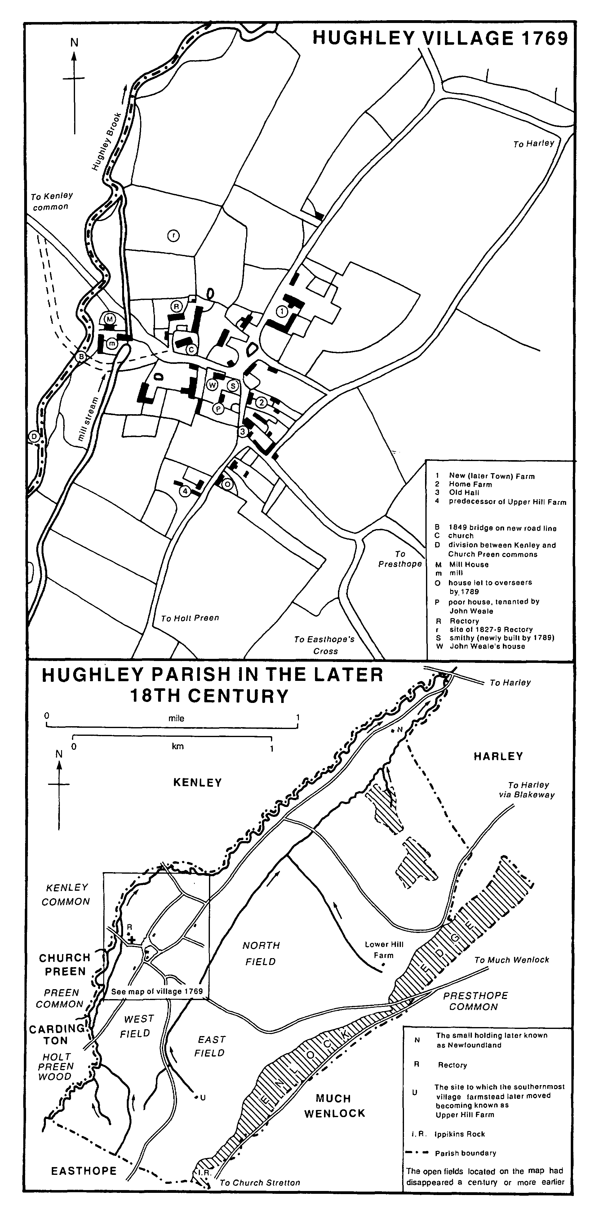
Hughley in the 18th Century
The woods (hatched) were earlier and later more extensive.
Roads from Church Preen and Kenley (the latter by a new route of 1796) (fn. 10) converged from the west to ford Hughley brook north of the mill, where the valley was steep sided, and so to enter the parish and village. In 1849 the brook was bridged and the road rerouted southwards to achieve a gentler gradient. (fn. 11) Hughley's only thoroughfare, the road crosses the parish roughly eastwards and climbs the scarp of Wenlock Edge by a route shifted south in the late 18th or early 19th century; at the top, on the parish boundary where Presthope common was, it joins the road from Much Wenlock to Church Stretton.
In the mid 18th century there were other, if minor, thoroughfares. A lane beside the brook may once have led to Harley but by 1769 probably served only a smallholding at the north end of the parish. What in 1769 was still the road to Harley (via Blakeway) ran north-east from Hughley village, its two right-angled bends probably indicating the original extent of the wood (represented by Finnalls coppice) that it had to skirt; it was perhaps falling into disuse as a thoroughfare by the late 18th or early 19th century. Lanes from the village that had once led south-west via the West (or Middle) field, probably to common land in Holt Preen, and south to Easthope's Cross ('Colway') ceased to be thoroughfares probably between 1789 and 1817, when they apparently ran only to farms and fields. The former survived as a footpath, carried over the brook and into Holt Preen by a footbridge, one of several that may be successors to the 18th-century bridges thrown across the brook by farmers determined to get access to Preen and Kenley commons. The old lane to Easthope may have been replaced by a route from the Hughley-Presthope road along the foot of the Edge, though that (in existence by 1817) may have been only a private way to Upper Hill Farm, built after 1789. (fn. 12)
The railway from Much Wenlock to Craven Arms was constructed for c. 1.75 km. through the south-eastern edge of the parish c. 1865, entering it from Wenlock through a tunnel under the Edge; the nearest station was at Presthope. The line closed in 1963. (fn. 13)
Hughley village, in the 18th century the parish's only settlement apart from two or three
farmsteads and perhaps a cottage near the brook,
stands near the parish's western boundary on a
northward spur of higher land east of Hughley
brook. (fn. 14) Mill Farm and the church stand higher
than the rest of the village, though not so high
that
The vane on Hughley steeple
Veers bright, a far known sign,
for there never was a tall steeple. (fn. 15) To the west,
where the land falls sharply to the brook, was
the mill, but mill pool and leat were largely
obliterated in the mid 20th century. The old
rectory (called the Manor House from c. 1955) (fn. 16)
and the rest of the village stand on ground falling
gently north and east from the churchyard. The
Old Hall near the south end of the village is
16th-century; it was presumably one of the two
houses (both occupied by Corfields) taxed on 4
hearths in 1672 when four others had 2 hearths
each and the rest 1. (fn. 17)
An intricate network of lanes in and around the village was progressively simplified from the late 18th century, (fn. 18) probably as two or three village farmsteads were replaced by new ones amid their fields: in the east Lower Hill Farm, tiled and timber framed, existed by 1769 as did a smallholding (known as Newfoundland by 1851) (fn. 19) in the northern tip of the parish. In the south, probably by 1817, (fn. 20) Upper Hill Farm had been built to replace a timber framed house at the south end of the village, which had been in disrepair in 1789. Most houses in the village were timber framed and thatched or tiled in 1789, but a new smithy had been built in brick and tile. In the 19th century a brick building that was possibly a Sunday school room was built a furlong out of the village on the Presthope road; (fn. 21) later it became a pheasantry or keeper's cottage. (fn. 22) The landlord rebuilt other farms and houses in locally made brick with tiled or slated roofs, and a new brick Rectory was built in 1827-9. Hughley thus acquired a distinctive appearance amid the area's stone built upland settlements. (fn. 23) By 1990 there were some modern houses and bungalows, and outbuildings near Church Farm were being converted to domestic premises that year; there were standings for mobile homes north of the old mill. (fn. 24)
Evidently by c. 1900 the parish was supplied with water piped by gravity from a source under Wenlock Edge. (fn. 25) A reservoir near Upper Hill Farm was made by 1972. Local residents own the system. (fn. 26)
The recorded Domesday population of Wen lock priory's unnamed ½ hide, almost certainly at Hughley, was 1 villanus. (fn. 27) Seven people in Hughley paid to the subsidy of 1327, (fn. 28) 13 to the subsidy in 1524-5. (fn. 29) In 1672 hearth tax was paid by 17 households, (fn. 30) and in 1676 the adult population was 80. (fn. 31) There were 86 people in 15 households in 1793, (fn. 32) and over the next half century the population increased to a recorded peak of 127 in 1841. In the mid 19th century it was around 100, but after 1881 it fell for half a century and was 52 in 1931. Thereafter it was c. 60, the number of households increasing from 15 to 20 between 1971 and 1991. (fn. 33)
The parish wake was formerly held on the Sunday after the decollation of St. John the Baptist (29 August). (fn. 34) The parish is not known ever to have had a public house. (fn. 35) A men's social club, run by the curate, flourished briefly c. 1905. (fn. 36) Church Preen and Hughley village hall was built at Preen Common in 1934. (fn. 37)
The picturesque Ippikin's Rock on the parish boundary, jutting out from Wenlock Edge over a cave entered from Hughley woodland, generated folk tales of robber bands, buried treasure, and ghosts. (fn. 38) A distinct legend about the spot may be a garbled tradition of the death (1723) of Sir John Wolryche, the last of his family to own Hughley. (fn. 39)
MANOR.
King Cenred of Mercia (reigned 704-9) gave an 8-hide estate at 'Lingen' to a nun called Feleburg and in the reign (709-16) of his successor Ceolred she gave it to St. Mildburg. (fn. 40) A suggestion that 'Lingen' is a 13th-century rendering of an earlier 'Lege' (or 'Lige') links it with ½ hide in Condover hundred held of Wenlock priory in 1086 by an unnamed son of Aelfric (Aluric). The son was perhaps the Eadric (Edric) of Wenlock who held Bourton of the priory in 1086, having inherited it from his father Aelfric; Eadric of Wenlock was the priory's only recorded tenant in fee in 1086 (fn. 41) and may have been Edric the wild, (fn. 42) a leading Shropshire thegn of the Confessor's reign (fn. 43) last definitely mentioned in 1072. (fn. 44) The unnamed ½ hide is almost certainly to be identified with 'Legh' (or 'Leye'), later HUGHLEY, a manor held of the priory until it surrendered to the Crown in 1540. (fn. 45) Probably from 1548 it was held of the lord of Shipton by fealty and for 5s. a year (fn. 46) still owed in the earlier 18th century. (fn. 47)
The family which held Hughley and took its name (Lee) from the place is likely to have descended from Aelfric, for there is evidence that the family retained an interest at Bradeley, near Bourton, as late as 1281, when Sir Reynold of Lee gave a 24s. rent at Bradeley to Limebrook priory (Herefs.). (fn. 48) Thomas of Lee, possibly a descendant of Ranulph of Lee (fl. 1120), probably held the manor before 1176 and probably died before 1200 to be succeeded by his son Sir Hugh of Lee (fl. 1203). (fn. 49) In the earlier 1220s Thomas of Lee was probably lord, and Hugh of Lee, perhaps Thomas's son, probably succeeded himc. 1225. Hugh, probably the lord by whose name the place was to be distinguished from the end of the 13th century, (fn. 50) was still alive in 1271 but was probably dead by 1283 when Sir Reynold of Lee, probably his grandson, was patron of the living and presumably lord. (fn. 51) He remained lord in 1316 (fn. 52) and perhaps as late as 1337 or 1340, when the lord's name was the same. (fn. 53) He probably had a son Richard, for Richard of Lee's son Reynold of Lee occurred as lord 1369-73. (fn. 54) The latter may have left a male heir, for Roger of Hughley was patron of the living in 1391 and so probably lord of the manor. (fn. 55)
Probably after 1391 Hughley passed to the male issue of Joan, sister of Reynold (fl. 1369- 73), and her husband and survivor Thomas of Gatacre, (fn. 56) lord of Gatacre (in Claverley) 1345- 68: (fn. 57) they had sons William (fl. 1398-9), probably the elder dying without issue, and Thomas (fl. 1392), (fn. 58) possibly born c. 1327. (fn. 59) Hughley descended with Gatacre until the early 17th century. (fn. 60) Thomas Gatacre (fl. 1392) and his sons Thomas and John were alive in 1404, (fn. 61) and the family estates, including Hughley, eventually came to John, presumably lord in 1426. He died in Henry VI's reign, and after him came his son John and grandson John. It is not certain which of these latter Johns was alive 1463-75 and in 1487, was lord in 1468, and was returned M.P. for Bridgnorth in 1470 and 1472. Possibly all those references (fn. 62) are to the third John (fn. 63) (d. 1499). (fn. 64) He may have settled Hughley, or an interest therein, on his second wife Eleanor, for after his son Robert's death in 1509 she and her husband Roger Vaughan made claims on it, against Robert's son William among others. (fn. 65) The manor was held by William (d. 1577) in 1560-1, (fn. 66) by his son Francis (d. 1599), (fn. 67) and by Francis's son William. (fn. 68) Francis was a recusant, and during his time the Crown confiscated the manor, leasing it to the Pigotts, probably Francis's relatives. (fn. 69)
William Gatacre was in debt to the Shrewsbury lawyer Thomas Harris (fn. 70) from 1607 when he mortgaged Hughley to him. (fn. 71) In 1611, as part of the ordering of Gatacre's affairs, (fn. 72) his brother-in-law Francis Wolryche (fn. 73) (d. 1614) of Dudmaston acquired Harris's interest. (fn. 74) Hughley then descended with Presthope until Godolphin Edwards of Frodesley sold it in 1745 to Orlando Bridgeman of Blodwel. Bridgeman (4th bt. 1747, d. 1764) bought Presthope in 1746 and the manors again descended together until Sir Henry Bridgeman sold Presthope in 1790. (fn. 75) He failed to sell Hughley (fn. 76) and until 1919 it remained with the Bridgemans, (fn. 77) of Weston under Lizard (Staffs.) since 1763, (fn. 78) Barons Bradford from 1794, and earls of Bradford from 1815. (fn. 79)
The estate included virtually all the parish (except the rector's glebe) in 1919 when it was sold, apparently without the manorial rights, of which no later mention is known. By 1922 some farmers owned their farms but Upper Hill farm, 206 a. at the south end of the parish, belonged to Maj. G. R. Benson of Lutwyche, who owned it until 1938 (fn. 80) or later but not in 1947. (fn. 81)
The site of the house built in the early 1470s by the tenant of the demesne (fn. 82) was probably indicated by the remains of a moat, apparently near Hughley Old Hall, c. 1914. (fn. 83) The Old Hall near the south end of the village, described as the manor house c. 1830, is mainly of the later 16th century with later additions or alterations. No lord resided after the 14th century so it seems possible that the house was built for the lord's relatives the Pigotts, lessees of the manor in the late 16th century. The main range has three timber framed bays of two storeys with attics over and has a projecting central former entrance porch to full height and gabled. A two bayed gabled range to the right is probably earlier; a single-storey mid 19th-century range projecting forwards at right angles was demolished. Plaster work inside closely resembles work in Wilderhope Manor and other nearby houses; at Hughley and Wilderhope the same moulds appear to have been used, including one for a motif that has seemed to suggest recusancy at Wilderhope. (fn. 84) In 1769 Mr. Corfield-probably John (d. c. 1777), tenant since before 1743-occupied it as lessee of 244 a. for life, (fn. 85) and from c. 1778 it was held by Samuel Madeley with 193 a. (fn. 86) By 1839, (fn. 87) however, and probably for a century or more thereafter, it was divided into small dwellings and became increasingly dilapidated until its restoration, as one house again, in 1952-3. (fn. 88)
ECONOMIC HISTORY.
If, as seems likely, the ½ hide in Condover hundred owned by Wenlock priory in 1086 was Hughley, it may represent a fragment of a much larger, 8-hide, estate called 'Lege' given to St. Mildburg in the early 8th century. (fn. 89) That perhaps comprised Hughley's three neighbouring manors of Harley, Kenley, and Preen, together amounting to 8 hides in 1086. (fn. 90) If so, ancient links between the four manors and the church of Wenlock may be detected in the property in Harley manor belonging to Wenlock priory and eventually incorporated in Holy Trinity parish, Much Wenlock, (fn. 91) and in the intercommoning of woods and wastes by Hughley with Kenley and Preen. (fn. 92)
In 1086 the ½ hide that was almost certainly Hughley was occupied by 1 villanus with 1 ploughteam, and there was room for another team. (fn. 93)
The three open fields were known as the West, East, and North fields in the late 16th century. (fn. 94) They lay near the village but probably beyond areas of meadow closer in: (fn. 95) acres in the West field (probably that known as the Middle field in 1607) touched the mill fleam; (fn. 96) the East field (probably the South field of 1607) presumably lay between 'Colway' and the road over the Edge to Much Wenlock; (fn. 97) and the North (probably Lower in 1607) field lay due east of the village. (fn. 98) The West field contained inclosed meadows in the late 16th century. By 1639 the fields may have been mostly or entirely inclosed.
No woodland was mentioned in 1086, but the manor was in the Long forest (fn. 99) until disafforestation in 1301. (fn. 100) Wenlock priory made an assart there, probably in the mid 13th century. (fn. 101) The slopes of Wenlock Edge, forming the manor's south-eastern margin, have probably always been wooded. The south-western and north-eastern ends of the manor, adjoining Easthope wood and Harley respectively, were evidently wooded in early times, the bends in the old way to Harley probably indicating the original extent of the wood later represented by Finnalls coppice. (fn. 102) Except perhaps when the whole property was leased (as to the Pigotts for 30 years in Elizabeth I's reign) (fn. 103) the lord probably kept the woods in hand. (fn. 104)
In the late 16th century the rector had common pasture in the fields and common for 6 beasts, a horse, sheep, and swine and 'other cattle'. Manorial tenants presumably enjoyed similar rights, which were perhaps being whittled away in the earlier 18th century when the lord was making them small allowances for excluding their animals from parts 'hayed up' to protect his coppices and timber. (fn. 105) Hughley was a small manor, and its tenants enjoyed common rights beyond its bounds. They intercommoned Haywood as late as the 1530s, (fn. 106) and the rector (fn. 107) and tenants certainly had rights on Kenley common.
The lord of Hughley's annual rights on Kenley common were defined in 1203 as 60 cartloads of dead wood, freedom from pannage dues for 60 pigs, and pasture rights for himself and his tenants; in return the Hughley tenants owed mowing services to the lord of Kenley. Goats which the Hughley tenants turned out on the common in 1231 were seized and kept by the Kenley men, (fn. 108) and Hughley's rights there were disputed in the 17th century. (fn. 109) It was presumably for intercommoning that the Hughley tenants owed wood hens at Christmas to the lord of Kenley, a due that had been commuted to 15s. a year by 1769. (fn. 110)
Hughley tenants also turned their animals out on Church Preen and Holt Preen commons, though not unchallenged in the 17th century, and they apparently pushed their claims when those two manors were in the hands of impoverished lords in the early 18th century. In return for access to Church Preen common the Church Preen demesne corn was ground free at Hughley mill and free use of a Hughley bull and boar was allowed. Even so Hughley claims on Church Preen common were strenuously resisted in the mid 18th century. In Holt Preen wood in the earlier 17th century the lord of Hughley had incited his tenants to throw open the lord of Holt Preen's attempted inclosures. Much common in Holt Preen, however, seems eventually to have been inclosed by Samuel Edwards (d. 1738); he was lord of Hughley too and, perhaps to avert opposition, added newly inclosed land to the leasehold of at least one of his principal Hughley tenants, John Corfield. Another of Edwards's tenants, the 'arbitrary' Lancelot Corfield, was an energetic leader in claims on Church Preen and other commons, carrying on the tradition of the 'Hughley Lions' who had broken open Church Preen cottagers' inclosures on the common when they would not work for the Hughley men at harvest or 'cringe and bend'. (fn. 111)
Kenley and Church Preen commons were inclosed in the 1780s. The lady of Church Preen, who had failed to inclose the common c. 1762, announced in 1779 that she intended to inclose it. She clearly succeeded, for in 1789 a Hughley farmer and seven smaller tenants held 140 a. in Church Preen and Holt Preen, at least 52 a. of which had evidently been allotted to their landlord; the lord of Hughley's allotments in Church Preen parish may have amounted to 70 a. In the same year two Hughley farmers held 57 a. that had been allotted to their landlord in Kenley. The rector of Hughley was allotted 3 a. in Kenley parish and 3 a. in Church Preen. (fn. 112)
Hughley had no resident lord after the 14th century and in the early 1470s the demesne was let, the tenant being allowed 46s. 8d. to build a house and chamber. (fn. 113) There were usually half a dozen farms of 50-250 a. from the earlier 18th century, when at least three farms, including the two largest, were leased for lives. In 1769 there were six tenants holding less than 10 a. and one with 36 a. The farmsteads were almost all in the village, though in 1789 one had a hill barn and fold yard on the Edge near where Upper Hill Farm was later built. In 1789 nine tenants held less than 25 a., the two most substantial being the miller and the blacksmith. There was then little land on lease, and the landlord seems to have made changes to the holdings as tenants changed. There were, however, continuities: the Madeleys were farming in Hughley by 1772 (fn. 114) and their descendant Frederick Hill continued to farm there until the late 19th century, (fn. 115) while from the early 16th century Corfields (fn. 116) were tenants, (fn. 117) though not continuously; they farmed there in the 1920s and at Lower Hill farm from 1948. (fn. 118)
Stone was evidently quarried in the 1460s. (fn. 119) There were fields called Coalpit field (1769) and Furnace piece (1839), (fn. 120) but the Hughley ironworks, (fn. 121) with which they were perhaps connected, was probably across the brook in Kenley parish. (fn. 122) Until the 20th century there were a few tradesmen: blacksmith, butcher, miller, and wheelwright, some of whom also held land. In the 1860s and 1870s there were carpenters and bricklayers, and a claypit and brick and tile works south of the road to Presthope at the bottom of the Edge, in existence by 1881, may date from then; it evidently closed well before 1901 when the site was wooded. By 1881, perhaps by 1872, there was a grocer's shop. Until just after the First World War successive shopkeepers combined their business with smallholding; in the 1930s the shop became a post office too, but it closed some time after 1941. (fn. 123) By the mid 1960s there was a caravan park north of the old mill, and by 1990 the development of a riding centre and 'holiday park', with caravan and tent pitches, on the 200-a. Mill farm represented a diversification of the local farming economy. (fn. 124)
Cattle were probably always of first importance: in 1747 the parish bought '3 papers upon the Distemper of Cattle', and much hay was grown. (fn. 125) In 1801 almost all the arable was under wheat and oats, about twice as much wheat as oats; small quantities of peas, barley, roots, and potatoes were also grown. (fn. 126) The arable area evidently increased and by 1839 amounted to almost half of the parish; after the mid 19th century, however, it declined. (fn. 127) Oats remained the second cereal to wheat during the 19th century, being displaced by barley in the 20th. Sheep were the main livestock in the 19th century, though significant numbers of cattle and pigs were also kept. With a local emphasis on dairying in the early 20th century cattle took first place, but pig keeping declined. Hughley was always mainly pastoral, even during the boom in arable farming after the Second World War: in the early 1960s Hughley had less arable than most of the surrounding parishes, though its pastures were perhaps less intensively stocked. (fn. 128)
Sources: P.R.O., MAF 68/143, no. 15; /1340, no. 5; /3880, Salop. no. 67; /4945, no. 67.
Woodland, c. 150 a. in the 18th, 19th, and 20th centuries, was mainly along the upper scarp of Wenlock Edge but with coppices in the north (Finnalls) and beside Hughley brook (Gwyn's). (fn. 129) By the later 18th century the coppices and hedgerows contained much good timber and the lord made c. £44 a year from coppice wood. In the early 18th century woodland 'a long mile in length', probably that along the Edge, was well stocked with game, and the lord employed a keeper; (fn. 130) the shooting, and indeed sporting rights over the whole estate, were let in the early 20th century. (fn. 131) Hughley brook was described as a good trout stream in the early 18th century. (fn. 132)
The village mill existed by the 16th century (fn. 133) and probably much earlier. In 1789, and probably 1834, its overshot wheel powered two sets of stones. (fn. 134) It ceased working c. 1920; (fn. 135) by 1952 the machinery had been demolished and one or two millstones were lying about. (fn. 136)
LOCAL GOVERNMENT.
The lord of Hughley owed suit at Shipton court leet in the 16th and 17th centuries but seems usually to have defaulted. (fn. 137) His suit was perhaps personal because he held Hughley of the lord of Shipton, (fn. 138) and inquisitions and deeds which, at least until 1758, seem to represent Hughley as being within the leet of Shipton (fn. 139) are perhaps misleading, for the manor owed suit to the twice yearly leet of Bourton hundred from 1198 (fn. 140) until as late as 1749, though rendering it with diminishing frequency in the earlier 18th century. (fn. 141)
The only known records of Hughley manor court baron are estreats of 1634-5 (fn. 142) and presentments of 1676-7. (fn. 143)
The parish repaired the stocks in 1666, when it also made a pound which it later kept in repair. (fn. 144) The parish mended its bier in 1681 and bought a new one in 1840. (fn. 145)
From the late 17th century or earlier the vestry relieved the poor in a wide variety of ways, including grants in lieu of wages and for clothing, fuel, rent, house repair, sickness, and burial. Bastard children were maintained, and occasionally (as in 1686) a cottage was built for a poor family. A poor woman had her corn threshed on the rates in 1745. By 1694 and until 1762 there was a poor's stock of £2 out at interest. A poorhouse was rented in the mid and later 18th century, but whether continuously or not is uncertain. (fn. 146) One of two houses rented by the overseers was said in 1789 to be ripe for demolition. The other may have continued in use, for one was repaired c. 1815, but there was probably no house for some years before 1827 when the 'Old House' (apparently part of the village farmstead replaced by Upper Hill Farm) was taken and two male paupers ordered into it. (fn. 147) Eight adults received permanent outdoor relief and five occasional relief 1812-14; both figures increased by one in 1814-15. Expenditure on the poor averaged almost £39 between 1812 and 1834; it was above that in 1819, 1821-2, 1824-7 (peaking at almost £59 in 1824), and in the earlier 1830s. (fn. 148) There was normally one overseer, but two were appointed in 1816-17 and 1821-2. (fn. 149)
In the 18th century the vestry appointed a highway surveyor (fn. 150) and paid for road repairs out of the poor rate. (fn. 151) The vestry remained a highway authority, latterly under the 1835 Act, (fn. 152) until 1895. (fn. 153) From 1983 Hughley had a joint parish council with Kenley and Church Preen. (fn. 154)
Hughley formed part of Atcham poor-law union 1836-1930 (fn. 155) and Atcham rural sanitary district from 1872. (fn. 156) When the borough of Wenlock acquired sanitary powers in 1889 Hughley was removed from it, remaining in Atcham R.S.D. (fn. 157) until 1894. It was in Atcham rural district 1894-1974 and from 1974 in the district (later that year borough) of Shrewsbury and Atcham. (fn. 158)
CHURCH.
In the 1170s Peter de Leia (Lehe), prior of Wenlock, granted the chapel of Lee, i.e. Hughley, and its patronage to Thomas of Lee, lord of the manor. (fn. 159) In early times the chapel may have been a dependency of Cound church, (fn. 160) but perhaps from the 12th century, (fn. 161) and until the later 16th century, it was in the parish of Holy Trinity, Much Wenlock. (fn. 162)
The patronage belonged to the lord of the manor. (fn. 163) In 1415 a turn was exercised by John Fitzpiers, (fn. 164) probably a lawyer or feoffee, (fn. 165) and the bishop collated by lapse in 1564 and 1580, when the patron, or perhaps the lessee of the advowson, was a recusant. (fn. 166) The lord sold his estate in 1919 (fn. 167) and passed the advowson to the bishop of Hereford in 1926. (fn. 168) Next year the benefice was united with another in the bishop's patronage. (fn. 169)
Under the terms of Prior Peter's grant (fn. 170) the clerk presented was not to enjoy his benefice until he had sworn before the prior and convent to save for the mother church of Wenlock the mortuaries and other dues (legata et cetera) belonging to it and to pay 2s. a year to the priory sacrist; the clerk's own chaplain was similarly bound. The lord of the manor was to compel performance of their oaths if necessary and had to be at the priory at Christmas, on the translation of St. Mildburg (2 February), (fn. 171) at Easter and Whitsuntide, on St. John the Baptist's day (probably 29 August), (fn. 172) and on the invention of St. Mildburg (probably early November). (fn. 173) The 2s. pension was still paid when the priory surrendered in 1540, and in 1548 the Crown granted it with Shipton manor to Sir Thomas Palmer. (fn. 174)
Cure of souls in Hughley belonged not to the chaplain (fn. 175) or rector (as the incumbent was called by the 1350s) (fn. 176) but to the vicar of Much Wenlock, whose consent was required for solemnizing a marriage at Hughley in 1546. (fn. 177) Nevertheless Wenlock priory did not appropriate Hughley's tithes, (fn. 178) and apparently by 1576 the rector could bury. (fn. 179) The church was called parochial by 1592. (fn. 180) The rectory was united informally with the living of Church Preen 1851-74 and from 1891; (fn. 181) the union became formal in 1927. (fn. 182) Hughley was served from Frodesley 1943-65, from Harley 1965-73, and from Much Wenlock after 1973. (fn. 183) In 1981 the benefice of Hughley with Church Preen was merged in the Wenlock team ministry. (fn. 184)
The living was valued at less than £4 a year in 1291 and £4 7s. 8d. in 1536, (fn. 185) perhaps an underestimate: the benefice was worth £6 13s. 4d. in 1366 and £5 3s. 4d. in 1414; a rector retired with a pension of £4 in 1415, though that may have prevented his successor from residing. (fn. 186)
By the late 16th century the rector had something over 25 a. of glebe with common rights. By the late 18th century he received a 40s. modus for the tithe hay and clover of the whole parish, which, had it been taken in kind, would allegedly have equalled or surpassed all his other tithes, then worth c. £47 a year; in return for accepting the modus the rector was exempt from parochial taxes. His glebe was then almost 35 a. valued at just over £29 a year, and the lord of the manor paid the rector's land tax. At the inclosure of Church Preen and Kenley commons in the 1780s the rector was allotted 3 a. in each parish. In 1810 the parsonage grounds and glebe amounted to almost 37 a. For his tithes c. 1810 the rector took the eleventh wheatsheaf, the tenth cock of barley, oats, and peas, and the hay modus, then £1 18s. 10d.; clover mowed for seed was tithed as grain. The tenth fleece and the tenth lamb, pig, and goose belonged to the rector, and he took 20d. a score for over-wintered sheep, 6d. for a cow in calf, 1d. for a barren cow, 4d. for a swarm of bees, and 8d. for 'running of the mill'; he also tithed apples and potatoes. (fn. 187)
Worth £30 c. 1708, the rectory was augmented in 1724 with the aid of Queen Anne's Bounty. (fn. 188) The rector's annual income was £146 in 1835, (fn. 189) probably less than half of it in tithes, which yielded just over £56 a year 1829-35 on an 'exceedingly low' composition as they were no longer collected in kind; (fn. 190) they were commuted to £73 0s. 10d. in 1839. (fn. 191) In 1851 the living was worth £160 gross: besides the tithe rent charges there was £32 a year from glebe and £55 from other land, (fn. 192) presumably that bought by Queen Anne's Bounty and the Church Preen and Kenley allotments: (fn. 193) in 1887 the glebe, 88 a., included all that. (fn. 194)
Osbert, the chaplain who attested the prior's grant in the 1170s, may have been deputy to the incumbent of Hughley chapel. (fn. 195) Some of the 14th-century incumbents may have been related to their patron; (fn. 196) one, Master Philip of Lee, rector and pluralist in the 1350s and 1360s, was a civil lawyer. (fn. 197) From the 17th century (fn. 198) almost all rectors were graduates (fn. 199) and many held a living, mostly nearby, in plurality, Quatt 1695- 1708, (fn. 200) Church Preen 1708-22, Easthope 1745-77, (fn. 201) Sheinton 1777-86, Little Wenlock 1786-1803, (fn. 202) Willey 1804-13, (fn. 203) Ospringe (Kent) 1815-26, (fn. 204) and Church Preen almost continuously after 1851. (fn. 205) Curates were employed at least some of the time. (fn. 206) W. H. Shields, 1903- 7, was the last absentee rector, (fn. 207) C. E. B. Deacon, 1936-43, the last resident. (fn. 208)
Some pluralists resided in Hughley as did Jacob Littleford, his kinsman's curate there 1698-1708 and rector 1708-22. (fn. 209) He gave the third of the four new bells of 1701 (fn. 210) and left charitable bequests for the parish. (fn. 211) The parsonage was said to be five bays including the barn in 1607 but four bays including a backhouse and excluding a barn of three bays in 1639. (fn. 212) It was rebuilt in brick 1711-23, Littleford's work being finished by his successor, (fn. 213) in whose time the patron gave a new silver chalice and paten (1725). (fn. 214) A new parsonage, designed by W. & J. Nicklin of Tipton (Staffs.), was built in 1827-8 by the first resident rector for fifty years; the patron gave £100. (fn. 215) The house was sold with 5¼ a. in 1953. (fn. 216)
In the early 18th century, and until 1777 or later, there were two Sunday services, one with a sermon. Communion was celebrated at Christmas, Easter, and Michaelmas. (fn. 217) By the 1790s there was communion four times a year, but congregations were small, with barely a dozen communicants. There were psalm singers c. 1806. In 1851, as in the 1790s, Sunday services were alternately morning and afternoon; on Census Sunday 60 adults and 22 children attended afternoon service. (fn. 218)
The church of ST. JOHN THE BAPTIST, (fn. 219) built of limestone rubble with sandstone ashlar dressings, has a structurally undivided nave and chancel with a timber south porch. (fn. 220) The thickness of the walls suggests that they may be 12th-century but the earliest datable features are two 13th-century lancet windows, with squaretopped shouldered rear arches, in the north wall of the nave. All the other windows and the north and south nave doorways are 14th-century. The east and west windows are of three lights and have curvilinear, almost flamboyant, tracery, the east unusual in form and the west perhaps renewed; the east window contains fragments of late medieval glass. In the chancel there is a 14th-century pillar piscina against the south wall, and a 14th-century female corbel head in the east wall presumably served as an image bracket. (fn. 221) The porch (repaired in the 1680s and 1690s and in 1702 and 1900) (fn. 222) has sides containing continuous lights with 14th-century tracery. A late medieval rood screen displays a richness of decoration unparalleled in the county; (fn. 223) with others in the Welsh Marches it may have been made in or near Ludlow, perhaps c. 1500. (fn. 224) It intercepts a nave window on the south and a chancel window on the north but may originally have stood farther west; if so, it was presumably moved before 1786, when the present division of nave and chancel was already fixed. (fn. 225) A steeple or bell turret, timber with brick infill and formerly surmounted by a fleche, was erected in 1700 (fn. 226) and contains a clock presented in 1893 by the patron to celebrate his colt Sir Hugo's win in the 1892 Derby. (fn. 227) The octagonal font looks 18th-century but apparently replaced an 'ancient circular' one, the 'clumsy workmanship of the village artist', that was in the church c. 1830. (fn. 228)
The church was restored and repaired in 1842 with aid from the Incorporated Church Building Society; the work included the repewing of the nave to add 39 sittings, 35 of them free. The new front pews met the screen whose bottom panels were evidently then preserved by being fixed to the east wall of the chancel as a sort of dado. (fn. 229) In the mid 19th century the screen, on which traces of original colour were visible in 1866, was painted 'oak'. Norman Shaw restored the trussed rafter roof in the 1870s, when, presumably, a 'modern stuccoed' ceiling (perhaps early 19th-century) was removed; (fn. 230) the boarding and most of the ribs and bosses are probably from that time. It was perhaps about then that the sunken boiler house was built against the north wall of the chancel. (fn. 231) Further restoration c. 1900 included repair of the east window jambs, repewing and reflooring of the nave, and removal from the nave 'gangways' of many 14th-century tiles (fn. 232) with incised decoration (including St. Mark's lion) and traces of original colouring; the tiles were reset on the chancel floor. It was probably then that part of the medieval altar slab was moved from the floor at the chancel entrance and fixed to the east wall north of the altar. The repewing enabled the chancel dado panels to be restored to the screen. (fn. 233) The chancel south window was glazed in memory of Lord Bradford (d. 1915). (fn. 234) Work done in 1927 included the provision of a raked floor west of the nave doors to receive a two-manual organ, (fn. 235) though in 1990 the church had only a harmonium, which stood against the screen next to a Jacobean pulpit in the north-east corner of the nave. A long plain oak chest stood beneath the west window.
In 1552-3 the church had a chalice and paten of silver and two bells. (fn. 236) New plate and four new bells by Rudhall of Gloucester were given in the early 18th century. (fn. 237)
The registers begin in 1576 and, save for the 20th-century loss (fn. 238) of the 1812-37 marriage register, are complete thereafter. (fn. 239)
The churchyard was extended north and northwest in 1923 and 1977. (fn. 240)
NONCONFORMITY.
William and Francis Gatacre, successive lords of the manor and patrons of the rectory in Elizabeth I's reign, were recusants (fn. 241) but did not reside in Hughley. It is possible that their kinsmen the Pigotts, Crown lessees of the manor and advowson, were also unfriendly to protestantism, for the bishop collated by lapse in 1580. (fn. 242) There were no nonconformists in the parish in 1676 or 1716. (fn. 243)
Hughley was in the Broseley Wesleyan circuit in 1827-8 (fn. 244) and Bishop's Castle Primitive Methodist circuit 1850-5. (fn. 245)
EDUCATION.
Jacob Littleford, rector (d. 1722), left the parish 6s. a year to keep a poor child at school, but the money was misapplied in bread for the poor. (fn. 246) In 1819 the poor had no means of education, though they were 'very desirous' of it. A Sunday school begun in 1827 was supported by the rector in the 1830s and may still have existed in 1842 when a school room, possibly that a furlong south-east of the village, was mentioned. (fn. 247) By the 1880s children attended Church Preen National school opened in 1872. (fn. 248)
CHARITIES FOR THE POOR.
Jacob Littleford left 4s. a year for the rector to distribute to the poor. With his legacy for the schooling of a poor child it was spent on bread doles. (fn. 249) In the early 20th century 10s. (12s. 6d. after the parish clerkship, to which Littleford had left 2s. 6d. a year, had lapsed c. 1917) (fn. 250) was distributed annually in gifts of 2s. 6d. or 5s., but the annuity, charged on the Holt Preen estate, was lost in 1921. (fn. 251) By 1975 the only charity applicable to the parish was a share in Capt. S. H. Christy's, left in 1914 for poor widows in Cardington and neighbouring parishes. (fn. 252)