A History of the County of Somerset: Volume 3. Originally published by Victoria County History, London, 1974.
This free content was digitised by double rekeying. All rights reserved.
'Parishes: Ilchester', in A History of the County of Somerset: Volume 3, (London, 1974) pp. 179-203. British History Online https://www.british-history.ac.uk/vch/som/vol3/pp179-203 [accessed 11 April 2024]
In this section
ILCHESTER
The ancient parish of Ilchester, (fn. 1) about 4½ miles NNW. of Yeovil, lay on the southern bank of the Yeo or Ivel. Before 1838, and probably as a result of the establishment of the county gaol in Northover, the northern boundary of the parish crossed the river to embrace its site. (fn. 2) Its other boundaries also follow watercourses, to create an area nearly two miles wide at its widest point between Pill Bridge in the west and the boundary stone on the Limington road in the east, and just over a mile from Ilchester Bridge in the north to the southern boundary of Ilchester mead. The land is alluvium over lias, and provides rich pasture grounds to the west and south of the town, all below the 50 ft. contour. The area of the ancient parish was 653 a.; (fn. 3) since 1957 the civil parish has included Northover and part of Sock Dennis, giving a total acreage of 1,550 a. in 1961. (fn. 4)
Ilchester probably owed its early importance to its position as a crossing-point of a navigable river. A paved ford, possibly Roman, was still visible west of Ilchester Bridge in the late 18th century, (fn. 5) but was largely obscured when obstructions in the river under the gaol wall were removed and used to fill up a hollow in the debtors' court in 1804–5. (fn. 6) The Foss Way from Bath, a road from the Bristol Channel, either from Dunball or Uphill, and another from the east converged north of the river and divided below the crossing for Dorchester and Exeter. (fn. 7) A Durotrigian settlement was established south of the ford in the 1st century A.D., probably surrounded by a ditch and an earthen bank. (fn. 8) It was Romanized from the mid 1st century, perhaps as successor to the fort on Ham Hill, (fn. 9) and took on a typical Roman layout, extending well beyond the limits of the original defences, which were therefore levelled. A simple glacis bank of clay formed in the late 2nd or early 3rd century was later reconstructed with a palisade, tied back to posts set in the rear of the rampart. This in turn was succeeded by a wall in the 4th century. By a.d. 369 the town was the civitas of the northern division of the Durotriges, and bore the name Lendinis. (fn. 10)
Visitors in the 17th and 18th centuries noticed a double wall in places, (fn. 11) and William Stukeley claimed to have seen traces of stone and brick walls enclosing a rectangle 300 paces long and 200 broad. (fn. 12) A ditch could also be traced in the 19th century. (fn. 13) Excavation has established the course of the wall in the north, where Stukeley saw it, in the west, and in the south, where the position of a gateway over the Dorchester road has been found. (fn. 14) Evidence of Roman occupation outside the defences was plentiful in the fields south and east of the town in the 17th century. (fn. 15) There were burials along both sides of the Foss Way and the Dorchester road, and a villa stood in Ilchester mead. (fn. 16)
Roman occupation can be traced to the early 5th century, but there is only scattered evidence for continuity. (fn. 17) The defences of the town were potentially adequate to provide protection for moneyers by the end of the 10th century, though the possible removal of the mint to Cadbury might suggest little faith in them. (fn. 18) By 1087–8, however, the town was able to withstand attacks from Robert Mowbray. (fn. 19) An onslaught in John's reign was, however, more successful, Peter de Mauley and Walerand le Tyeis managing to throw down the walls, taking away the iron-bound gates to Sherborne castle (Dors.). (fn. 20)
The medieval town had four gates. East Gate, by which the Limington road left the town, was mentioned in 1242, and still stood in 1426. (fn. 21) North Gate, presumably at the southern end of the bridge, occurs in 1304. (fn. 22) West Gate is first mentioned in 1200, and was apparently still standing in 1605; it spanned the Foss Way and gave access both to the Exeter road and to the route to Pill Bridge and Langport. (fn. 23) South Gate, with St. Michael's church above it, was known as Michell's Bowe. (fn. 24) It was 'the greatest token of ancient building' which Leland saw in the town. (fn. 25) It first occurs c. 1230–40, and was probably still standing in 1576. (fn. 26)
The principal streets formed an A-shaped plan, the apex at the market-place, the bases at the west and south gates. The western arm, the Foss Way, was called West Street in 1318 and in the early 16th century, and High Street by 1390. (fn. 27) High Street was the usual name from the 16th century, though since c. 1900 the name West Street has been used for the southern portion. (fn. 28) The eastern arm, including the road from the bridge to the marketplace, was known as Cheap Street, the principal trading street in the Middle Ages. (fn. 29) The name occurs late in the 13th century in connexion with a shop, a stall, and a goldsmith's tenement. (fn. 30) Church Street was an alternative name from the end of the 17th century and the sole one from the later 18th century. (fn. 31)
At the junction of the two streets is the marketplace, known as Cornhill and Market Hill in the late 18th and early 19th century, when it was levelled, gravelled, and enclosed with chains. (fn. 32) Part of it was called the Parade, and it was the site of the stocks and the town well. (fn. 33) At the southern end of the green thus formed stands the Town Hall, formerly known as the Shire Hall or Sessions House, (fn. 34) successor to the 'king's house . . . where the pleas of the county' were held, which had to be repaired in 1266. (fn. 35) Almshouse Lane or Street, or South Street connects the two principal roads further south. (fn. 36) Its original course was south-east from High Street, emerging near the site of the present Rectory. (fn. 37) As an unnamed lane it occurs in the 13th century, (fn. 38) as Abbey Lane in 1424, (fn. 39) and after the foundation of the Almshouse at its northwestern end in 1426 as Almshouse Lane. (fn. 40) It seems also to have been known as Horse Mill Lane in the 16th and 17th centuries. (fn. 41)
West of High Street and apparently following the course of the town ditch was Yard Lane. It occurs in 1607 and was still visible in 1742. (fn. 42) It was connected to the market-place by Shire Path Lane, probably the site of the first county gaol. (fn. 43) The lane disappeared during the rebuilding of the western side of High Street in the early 19th century. (fn. 44) East of Church Street are Back Lane, Free Street, and Limington Road. Back Lane, the 'way leading towards New Mill' in 1349, (fn. 45) was Mill Street or Mill Lane in the 15th and 17th centuries, (fn. 46) and was thereafter extended southwards, east of the churchyard, towards Borough Green. By the end of the 17th century the whole road was known as Back Lane, but later as Back Street or Mill Lane. (fn. 47) Free Street was the name given to the southern part of the street from 1839 when twelve cottages were built on the glebe there. (fn. 48)
At the southern end of Back Lane was the triangular Borough Green. (fn. 49) As manorial waste it was gradually whittled away during the 18th century: one plot had been 'lately walled in' by 1725; in 1742 a tenant was allowed to rail in a piece of the green and plant a row of trees before his house; and in 1773 a lease for a new cottage and garden formerly taken from the green was given by the corporation. (fn. 50) Many of the houses there were let to labourers. (fn. 51) The last traces of the green disappeared when buildings on it were demolished and the road realigned between 1826 and 1838. (fn. 52) Pye corner, perhaps part of the green, occurs in 1781 and 1798 when eight newly-built houses stood there. (fn. 53) Other streets or lanes in the town included Gloverstret, found before 1212, (fn. 54) and Marrimore Street in 1709; (fn. 55) their positions are not known. Green Lane occurs in 1741, Brown's and Mill Path lanes in 1791–2, and Cock Lane in 1822. (fn. 56) The town also had a number of alleys, known as drings, leading from streets to buildings behind the street frontage. (fn. 57)
Outside the town was the road leading from the Foss Way to Pill Bridge and Langport, called Moorway or Moorstreet until the 18th century and later known as Langport Way or Pillbridge Lane. (fn. 58) Some attempts were made in the 18th century to develop the road in view of the trade to the warehouses and quay at Pill Bridge, (fn. 59) and the corporation sold building sites along it including one in 1723 to be built on within five years, the house to consist of 'two good lower rooms and chambers in proportion'. (fn. 60) One of the houses, converted into a farm building, remained in 1969.
Ilchester seems to have had one open arable field, known as Ilchester field in the 13th century and as West field in the late 14th century. (fn. 61) Parts were inclosed for both arable and pasture by the end of the 13th century. (fn. 62) Common meadows were also permanently divided from the 13th century, and further inclosure took place early in the 16th century. (fn. 63) Great mead was subject to commoners' rights until 1810. (fn. 64) The practice of dividing meadow into units of a sixth of an acre (sesters) in the 13th century evidently gave rise to the name Chestermead, an area which, judging by interlocking tenures, was originally intercommoned between Ilchester and Sock Dennis. (fn. 65) By 1354 the estate of Whitehall hospital included grassland described as a park, perhaps the area bounded by a bank and known as 'intrenchments' behind Castle Farm. (fn. 66)
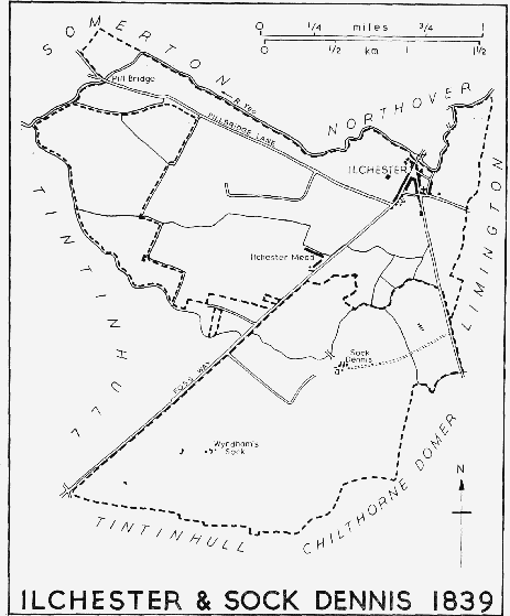
Ilchester and Sock Dennis, 1839
Ilchester and Northover together formed a bridgehead settlement. River traffic in Roman times stopped short of the ford just west of Ilchester Bridge, and traces of Roman quays have been found there. (fn. 67) Ilchester Bridge, while superficially a structure of 1797 is, however, of late-12thor early-13th-century origin. (fn. 68) The old bridge was of seven arches, the centre resting on a island in the river; the three arches between the island and the town were on a different alignment from the other four. (fn. 69) Further downstream, on the north-western boundary, Pill Bridge was built by the early 13th century. (fn. 70) The present high and narrow packhorse bridge was built in the 17th century. The lessees of Brook Ilchester in 1530 agreed to maintain the bridge during their tenancy, (fn. 71) and their successor in the mid 18th century was being required to make repairs. (fn. 72) A warehouse was established at Pill Bridge by 1699, and a house there, known as Pill Bridge House, survived until shortly before 1805. (fn. 73) The Lockyer family leased the house and warehouse and took tolls of all traffic between their wharves below the bridge and the town until trade disappeared at the end of the 18th century. (fn. 74) Plans to improve the Ilchester-Langport navigation in 1794 involved cuts below Pill Bridge at Great Yard and, though they were never entirely achieved, obstructions were removed and banks straightened so that coal barges could ply between Langport and Ilchester Bridge until the very end of the 19th century. (fn. 75)
Three small bridges carry roads from the south and east of the town across streams. Chear Bow, carrying the Foss Way over a brook at Ilchester mead, is mentioned in 1611. It is known as Spittle Bow or Mead Bow. (fn. 76) Bridges known as Cole Bow and Ilchester or Yeovil Bow respectively span streams on the Limington and Yeovil roads. (fn. 77) The Foss Way and the Yeovil road were turnpiked in 1754. (fn. 78)
At the end of the 18th century Ilchester was badly served by road traffic. No coach apparently passed through the town; there was only one waggon to and from Bristol each week, and goods from London were left at Yeovil. (fn. 79) The diversion of the Great Western Road brought London traffic, and by 1822 five coaches visited the town regularly, to London twice daily, to Exeter twice daily, to Bath every week-day, and to Bristol and Weymouth three times a week. Two carriers also served the town, one to London and Exeter three times a week, one to Bristol on Tuesdays, and to Yeovil on Fridays. (fn. 80) The number of coaches was even greater by 1839, but a year later some of the services had been abandoned in face of railway competition. There was only one coach on the London-Exeter run on five days of the week, and a summer service from Bath to Lyme Regis on three days. (fn. 81) The nearest railway station at Sparkford was no substitute for regular coach services, and Ilchester's short-lived revival was soon over. (fn. 82) Until the advent of regular omnibus services about 1926 no public transport served the town. (fn. 83)
Apart from the church of St. Mary Major (fn. 84) there is no building of medieval origin remaining in Ilchester. Leland remarked the 'wonderful decay' of the town, (fn. 85) but by the early 17th century it had been 'of late beautified in many places with good buildings', (fn. 86) and a house called Torrell's Court was singled out. (fn. 87) Part of the Dominican friary was still visible at the end of the 18th century, (fn. 88) and Cordelyon House, south of the Town Hall, evidently of medieval origin, survived until 1844. (fn. 89) One of the earliest surviving domestic buildings is the so-called 'Manor House' at the junction of West Street and Almshouse Lane. It is an Lshaped building of two storeys, basement, and attics, having rendered stone walls with Ham stone mullioned windows and dressings. It was evidently built in the mid 17th century but was partly remodelled about a hundred years later. The main block, facing West Street, has a symmetrical front crowned by three small gables. The pedimented doorway, approached by a double flight of steps, and the Venetian window above it, are 18thcentury additions. The east wing was altered in the 18th century to accommodate a new staircase and subsequently appears to have been shortened. The ground-floor room at the angle of the house has fine Jacobean oak panelling with Corinthian pilasters and an enriched frieze. Elsewhere the internal fittings, including panelling, doors, and staircase, are of the mid 18th century. The long service wing south of the main block was extended in the 19th century. A stable range in the yard is an early18th-century structure of red brick with Ham stone dressings. The central bay is faced with stone and contains an archway surmounted by a semi-circular window and a pediment; flanking it are mullioned and transomed windows and stone doorways with key-blocks.
West and High streets are continuously built up on both sides, mostly with smaller terrace houses of which the earliest date from c. 1820. At the north end of High Street, at the triangular market-place, there are a few slightly larger and older houses. A feature of the town in the 1830s, when, with few exceptions, its houses were 'indifferently built', was the several tenement blocks 'consisting of several storeys, and comprising on each different small tenements inhabited by burgage tenants at a nominal rent, and erected for their accommodation by the parliamentary patrons of the borough'. (fn. 90) Among these were two blocks of twenty or thirty tenements erected by the Whig, Lord Darlington, one of which, known as Cleveland Buildings or Row, stood in Back Lane. (fn. 91) The name was retained until 1841, and the tenements were also known as Trent's or Lower Barton. (fn. 92) They still stood in the late 19th century. (fn. 93) By 1822, and judging by their name built a few years earlier, were the tenements of Waterloo Double Building or Waterloo Court; and another such block, known as Castle Rookery, had been built behind the present Castle Farm by 1823. (fn. 94) A much larger complex, known as the Mead and containing 61 dwellings, was erected by Lord Darlington south of the town in 1818–19. (fn. 95) They survive as an isolated group of two terraces at right angles to one another. Each house is double-fronted and of two storeys. The range parallel to the road has a central pediment and the other a pedimented gable-end. They are otherwise plainly built of lias with dark-red tiled roofs and brick chimneys.
In the early 1840s, when Ilchester still benefited from its position on regular, if less frequent, coach routes, there were at least seven inns in the town. None appears to have had a continuous history from the 17th century, though the Bull is on the site of the Sun, in business between 1669 and 1734. (fn. 96) Other establishments in the town in the late 17th century were the Red Lion, probably also in the market-place, in existence by 1657 but closed before 1700; (fn. 97) the George later Swan, in Church Street by 1686; and the Bell, also in Church Street by 1690. (fn. 98) Several new inns, including the Ark, the Blue Bell, the Castle, the New Swan, the White Horse, and the Chough, had appeared by the 19th century, probably connected with the election struggles in the town. (fn. 99) In the 19th century the largest inn was the Castle; in 1840 coaches called there, but by 1854 it was converted to a farmhouse. (fn. 100) The Cow, the Dolphin, and the Victoria were opened by 1859. (fn. 101) Only the Bull and the Dolphin survived until 1969.
Seventeen friendly societies, some in existence for only a short time, appeared in the town between 1788 and 1845. The first was the Ilchester Benevolent (1788), followed by the Ilchester Benevolent Friendly (1788), the Ilchester Old Friendly (1798), the Ilchester Guardian, and the Ilchester Female Guardian (both 1801). (fn. 102)
Ninety-five communicants were recorded in 1548, (fn. 103) and c. 1750 there were said to be some 127 houses in the town. (fn. 104) A considerable increase in population must therefore have occurred during the later 18th century. In 1801 the figure was 942; it fell to 745 in 1811, owing at least partly to the eviction of his political opponents by Sir William Manners. (fn. 105) The population then rose steeply, to 994 in 1821 and 1,095 in 1831, again partly due to Manners, who offered houses and grazing to potential voters in his interest. (fn. 106) The figure remained at a high level in 1841, but for the rest of the century declined, reaching its lowest point, 433, in 1901. In the 1840s, when some 200 people left the town, several applications were made to the parish for assistance to emigrate to Australia and Tasmania. (fn. 107) The population remained at between 400 and 500 until the Second World War, but rose to 552 in 1951. The altered boundaries of the area obscure subsequent comparative figures, though new housing development has taken place within the limits of the ancient parish. There were 1,401 inhabitants in the civil parish in 1961. (fn. 108)
The town took a small part in the Civil War. The king stayed there in July 1644 during his campaign against the earl of Essex. (fn. 109) The Parliamentary forces planned to garrison it in January 1645, (fn. 110) but the Royalist forces remained, under the governorship of Col. Edward Phelips, until the summer of that year, when Fairfax manœuvred them out of the town just before the battle of Langport. (fn. 111)
Roger Bacon, born c. 1214, is generally thought to have been a native of the town or its immediate neighbourhood. (fn. 112) John Hoskins (1566–1638), lawyer and wit, taught at a school in the town c. 1592, while compiling his Greek Lexicon. (fn. 113) Mrs. Elizabeth Rowe (1674–1737), the authoress, was the eldest daughter of Walter Singer, a nonconformist minister in the town. (fn. 114) Edmund Waller, the poet, was M.P. for the borough in 1624–5, and Richard Brinsley Sheridan, the dramatist, was returned in 1807. (fn. 115)
Manor and Other Estates.
Ilchester was originally part of the royal Saxon estate of Somerton. (fn. 116) In 1066 it formed part of the holding of Queen Edith, (fn. 117) and in 1086 was held by the Crown. (fn. 118) Queen Eleanor, widow of Henry II, had the farm of the town (£28) from 1194 until 1203, and probably until her death in the following year. (fn. 119) King John granted the farm to Queen Isabel in 1204, (fn. 120) though it was later said to have formed part of the dower of Richard I's widow, Queen Berengaria. (fn. 121) The farm was confirmed to Isabel in 1216, (fn. 122) and she retained it until her death in 1246. (fn. 123) Her property was then granted to Richard, earl of Cornwall (d. 1272). (fn. 124) The farm of the town passed to his son Edmund (d. 1300), and then to Edmund's widow, Margaret. (fn. 125) It seems then to have passed to Piers Gaveston (d. 1312) on his creation as earl of Cornwall in 1307, and Margaret de Clare, Gaveston's widow, was given the farm for her life in 1316. (fn. 126) It was given to her second husband, Hugh de Audley, in 1317, (fn. 127) was lost and regained in the following year, (fn. 128) and was resumed by the Crown in 1319. (fn. 129) Thereafter it was held by Queen Isabel in dower from 1327, probably until her disgrace in 1330, (fn. 130) and from 1333 to 1336 was parcel of the duchy of Cornwall. (fn. 131) It then remained in hand, the farm being from time to time assigned to royal creditors, (fn. 132) until 1556 when it was given in fee farm to the burgesses, becoming what was later called the manor of ILCHESTER. (fn. 133) The corporation sold the manor to Sir William Manners in 1810 in return for land in Ilchester mead and the discharge of the fee farm rent. (fn. 134) Manners's son succeeded in 1833, (fn. 135) but sold it in 1834. The sale included about 70 private houses and 'almost . . . the entire . . . parish'. (fn. 136)
After the sale the property was divided into a number of holdings, the lordship of the manor passing to successive owners of Ivel House. Charles Boydell sold it to Harriet Shorland in 1843; Charles Harris (d. 1875) purchased it from Mrs. Shorland in 1847. It is thought that Mr. Harris was the last to hold a court. Harris's trustees sold it to Henry Mends, and in the following year it became the property of George Daunt. Mr. James Stevens Cox, who purchased the manor from Mr. Foy in 1937, also acquired Ivel House and the remaining manorial property, comprising the island on which the centre of Ilchester Bridge rests, a small piece of land in Pillbridge Lane, formerly used as a pound, and the freehold of part of the market-place. Until c. 1948 Mr. Cox collected tolls for the use of the market-place. (fn. 137)
An estate created in the 13th century by Henry de la Brooke, partly through his marriage to the daughter of Roger de Gouvis, lord of Kingsdon, (fn. 138) and partly through purchase, (fn. 139) was in 1325 a substantial property known as BROOK ILCHESTER, and later BROOKE'S COURT. Held of the Crown, it contributed a substantial sum to the fee farm of the borough, (fn. 140) and by 1331 comprised 84 a. of arable land, and 46 a. of meadow. (fn. 141) John le Brooke, who succeeded to the property in 1325, died in 1348 leaving a son, Thomas, as his heir. (fn. 142) Sir Thomas Brooke, Thomas's son, who succeeded as a minor in 1367, (fn. 143) was one of the county's leading political figures. He was succeeded by his son, also Sir Thomas, in 1418, and the property was shortly afterwards described for the first time as a manor, held in chief in free burgage. (fn. 144)
Edward Brooke, Lord Cobham, succeeded his father in 1439 and died in 1464. His son John (d. 1512) let the site of the manor and 150 a. of land to John Hodges of Long Sutton and his son for their lives in 1481. (fn. 145) The Hodges family were succeeded as tenants in 1518 by William Rayment and others, and Rayment and three sons had a lease for lives in 1530. (fn. 146) Subsequent tenants have not been traced, but the manor was still in the hands of William, Lord Cobham (d. 1597), great-grandson of John, Lord Cobham, at his death. (fn. 147) William's son Henry (d. 1619) was attainted in 1603 for his part in the Main Plot. His estate in Ilchester was granted to Joseph Earth of High Holborn, London (d. 1609), from whose brother Roger it appears to have come into the possession of Sir Henry Berkeley of Yarlington. (fn. 148) His daughter Dorothy brought it to her husband Francis Godolphin (d. 1666), (fn. 149) and in 1759 it was in the hands of her grandson Francis, Earl Godolphin (d. 1766). (fn. 150) By this time the estate appears to have comprised little more than ownership of Pill Bridge.
The exact site of the manor-house of Brook Ilchester or Brooke's Court is not known. Its lands lay chiefly in Ilchester mead, and Henry de la Brooke certainly had some land 'near the meadow of Sock and Martock'. (fn. 151) The family may, indeed, derive its name from the brook which separates Ilchester from Sock. The land presumably extended to Pill Bridge, and the tenants of 1530 were responsible for its repair and maintenance. (fn. 152) This responsibility was later put on the owner. (fn. 153) By 1633 traces of the manor-house itself could barely be seen. (fn. 154)
An estate called Torrells, thought to be so named from a family 'of eminent note' in Richard I's time and later, was held by Cecily, marchioness of Dorset (d. 1530), heir of William, Lord Bonville. In 1523–6 it comprised some 156 a. of land. (fn. 155) The Bonvilles had certainly been acquiring land in Ilchester since the late 14th century. (fn. 156) Before 1538, however, the 'heirs of Bonville' had disposed of some of the property, but still held 16 burgages and over 66 a. of land in fee. (fn. 157) It was held of Charles Brandon, duke of Suffolk, by John Cuffe in 1553. (fn. 158)
In the 1520s the property included a dovecot, stable, 'shepit', and a garden by 'Torrelles Corwate'. (fn. 159) A house called Torrells Court was still standing, near the site of the Dominican friary, in the 1630s. (fn. 160)
County Town, Gaol, and House of Correction.
The presence of the county gaol from 1166 and the regular meetings of the shire and circuit courts in the town gave Ilchester the status of the county town of Somerset. (fn. 161) Property in and around the town acquired by the county's leading landowners and at least one sheriff indicate the importance attached to the centre of county government at least during the 13th century. (fn. 162) The removal of gaol and courts to Somerton in the 1280s seriously harmed the town, but their return between 1366 and 1371, in an attempt to bolster Ilchester's economy, did not again attract investment. Thenceforward first the circuit courts and then the sessions forsook Ilchester. Thus the gaol was delivered at Somerton in 1530, (fn. 163) and at Crewkerne in 1547. (fn. 164) More often gaol sessions were held at Chard, though Ilchester was again chosen in 1569. (fn. 165) The spring meeting of the quarter sessions was regularly held at Ilchester during the 17th century, but only intermittently in the early 18th century. The last was held there in 1766. Magistrates disliked the town because of its poor accommodation. (fn. 166)
The gaol and county court remained to provide a living for the inhabitants who gave 'entertainment' to those visiting or attending. (fn. 167) The court still sat monthly for the recovery of small debts, and was summoned by the sheriff for parliamentary elections and other duties of the shrievalty. The town's position as the place for county elections was questioned in 1702: Wells and Taunton were suggested as alternatives, since Ilchester was 'such an odious place that there is neither meat, drink, nor lodging to be had'. (fn. 168) Ilchester itself was disfranchized in 1832, (fn. 169) and a writer, looking forward to this event, asserted that it would thus lose 'its last remaining claim to the distinction of a County Town'. (fn. 170) The redistribution of seats after the Reform Act set up electoral courts in Taunton and Wells, Ilchester being merely a polling place in the Western Division. (fn. 171) The closure of the county gaol in 1843 and the abolition of the county court at Ilchester in 1846 finally ended its claims as the county town. (fn. 172)
Complying (fn. 173) with the order made in 1166 to build gaols in counties where no gaols were to be found, the sheriff in 1166–7 planted a gaol for Somerset at Ilchester, (fn. 174) or at least then caused work to be done on an existing gaol there. In the 13th century it was used not only for felons but for forest trespassers, (fn. 175) and, at times at any rate, served Dorset as well as Somerset. (fn. 176) Orders for delivery began in 1233. (fn. 177) The building was expensively repaired in 1186–7 (fn. 178) and repaired again on ten occasions between 1194–5 and 1213–14. (fn. 179) Further works upon it were ordered four times between 1225 and 1272. (fn. 180) When surveyed in 1283 it was of both wood and stone. (fn. 181) It was abandoned in the 1280s. The last orders for delivery were issued in 1281–2 (fn. 182) and in 1283 there was a plan to give the building materials to the Dominican friars of the town. This plan was probably not carried out, (fn. 183) for in 1429 a recognizable tenement in or near the market-place, perhaps near St. John's church, was said to be one in which the gaol was wont to be of old (ab antiquo). (fn. 184) By 1280 a gaol, to replace Ilchester, had been established at Somerton, where it remained until 1371. (fn. 185)
It was decided in May 1366 that Ilchester should again become the meeting-place of shire and circuit courts. (fn. 186) But even before this, in March of the same year, Ilchester had already become the place for delivering Somerton gaol, and this practice continued until 1370. (fn. 187) By 1371 a gaol had once again been established at Ilchester, (fn. 188) and there it remained until 1843. In Leland's time it stood in the middle of Ilchester Bridge on the west side. (fn. 189) On a prison breach in 1533 it was found that the building had contained 22 prisoners, many chained. (fn. 190)
By an arrangement which has no exact parallel in England the revenues of St. Katharine's chantry in Ilminster church stood charged, at the time of dissolution, with a small annual payment to the prisoners. (fn. 191) This was continued by order of the charity commissioners in 1548, but has not been traced further. (fn. 192) By about 1586 an acre of ground in the common mead of Ilchester, called Gayle Acre or Begman's Acre, was set aside to provide for a horse, to be used by the begman 'to beg the county for the relief of the poor prisoners there', and from about the same time the justices authorized official collections for their benefit. (fn. 193)
Because the gaol house was thought too small and weak and was noisome, a new gaol was built in Northover parish about 1599. (fn. 194) At least by 1615 it was sharing premises with the house of correction, (fn. 195) though from 1624 onwards the two were divided, each having separate entrances. (fn. 196) Generally one man was in charge of both establishments. (fn. 197)
The site of the gaol, on land adjoining the river, was frequently flooded, and partly for that reason the gaol itself was unhealthy. (fn. 198) The buildings were fortified by Goring in 1645, and, on his retreat towards Langport, were fired by the governor of the town. (fn. 199) Accommodation became an acute problem when large numbers of Quakers and other nonconformists were confined there during the persecutions of the late 17th century. Other quarters, including the Friary, the Nunnery, and private houses were used. There were, for example, 212 Quakers imprisoned between December and March 1660–1; some were lodged with felons and on occasion held in irons, while at other times they were able to move freely in the town and even outside. (fn. 200) John Whiting, the Quaker, was imprisoned there 1679–86.
Unhealthy conditions continued to prevail throughout the 18th century, and there are records of none but minor repairs and improvements to the fabric. (fn. 201) Howard's criticism after his visit was not severe, his main point being that, though the apartments were roomy, the courtyards were too small, and the male felons were without a day room. The number of prisoners in February 1774 was 31 debtors and 22 felons. (fn. 202) An extension to the buildings was completed in 1789 and included 26 cells each with staples and rings fixed in the floor for chaining prisoners. (fn. 203) Large alterations were said to have been made between 1808 and 1821 by the governor William Bridle. (fn. 204) They included the division between the quarters for female felons and convicts, and the construction of 'refractory' and 'misdemeanor' wards. Yards were provided with covered arcades, dominated by the two-storeyed cell blocks. Until Bridle's time the prisoners had no opportunity for work, but prison labour provided many of the new buildings, a cloth manufactory was set up, and tailoring and shoemaking were practised. The extended buildings could house well over 200 prisoners, 238 being present in May 1818. (fn. 205)
William Bridle's conduct as governor was denounced by the radical politician Henry Hunt (1773–1835), imprisoned there for his part in the Peterloo demonstrations in 1819. (fn. 206) Hunt's strictures resulted in both a local and a parliamentary enquiry, and Bridle was dismissed on grounds of brutality. (fn. 207) The gaol continued in use until 1843, when it was replaced by Wilton gaol, Taunton. The site of the former gaol was purchased by the Tuson family, and converted into gardens. Two cottages, once part of the laundry and bakehouse, remain. (fn. 208) Until 1811 executions took place in a field known as Gallows Five Acres, on the west side of the Yeovil road. A new drop was subsequently erected above the front lodge of the gaol. (fn. 209)
The erection of a house of correction had been ordered by 1607, but there was some difficulty in levying money to finance the work. (fn. 210) It had certainly been built by 1613. (fn. 211) Two years later it is known to have comprised two rooms and a court in the buildings which housed the county gaol. (fn. 212) Although usually under the control of the keeper of the gaol, (fn. 213) the house was in 1624 clearly divided from the gaol and given a separate entrance. (fn. 214) It was occupied by troops in 1645 and damaged by fire. (fn. 215) In 1666 it was ordered to be reopened after some years of disuse, but thereafter it seems to have become simply a department of the gaol. (fn. 216) From 1691 the county gaoler was no longer paid a separate fee as keeper of the bridewell. Less serious offenders were certainly lodged at Ilchester in the late 18th century. (fn. 217)
Economic History.
The existence of a mint at Ilchester in the late 10th century is the strongest indication of both the economic and defensive strength of the town. A mint was established there in 973 which, though perhaps temporarily moved to South Cadbury late in the reign of Ethelred II in the early 11th century, continued to produce coins until c. 1250. (fn. 218) Ilchester had all the appearances of a borough by 1086; the third penny payable by the town was worth £6, its 108 burgesses paid a further 20s., and a market, evidently very thriving, was worth £11. (fn. 219) As in other parts of Somerset one burgess was connected with an outside estate, in this case Castle Cary, (fn. 220) and it has been suggested that the borough had similar links with the royal estates at Bedminster and Milborne Port. (fn. 221) The later claims of links with Somerton suggest rather that Ilchester, like Langport, lay within the orbit of that extensive royal manor. (fn. 222)
The original farm of the borough was £30, to which a rural estate, a mill, and Stone hundred contributed £10 10s. (fn. 223) In 1204 the Crown resumed Stone hundred and granted the estate in fee to William the Dane of Sock Dennis, but no reduction was made in the farm demanded of the burgesses for the loss of William's estate, and only occasionally for the loss of the hundred. (fn. 224) The community was thus from early times burdened with heavy financial responsibilities, made even heavier by the impositions of Richard, earl of Cornwall, in the mid 13th century. (fn. 225)
The town, however, bore all the marks of a thriving community. As early as 1200 there were houses outside the walls, suggesting an expanding population, and by 1276 there were at least six parishes. (fn. 226) The monastic houses of Glastonbury, Muchelney, Montacute, and Cerne (Dors.) acquired ecclesiastical patronage there, Montacute by 1180, Glastonbury by 1191, the others by 1242. (fn. 227) Muchelney had at least one house by 1227–8, Athelney had a rent, and by the end of the century Montacute, Bruton, and Sherborne (Dors.) had similar holdings. (fn. 228) In addition the Order of St. John of Jerusalem and St. John's hospital, Bath, had a stake there, the former by 1212, the latter by 1236. (fn. 229) There was also a leper hospital by 1212, a hospital, later a nunnery, by 1220, and a Dominican friary by 1261. (fn. 230)
In contrast lay families seem to have been less interested in the town's potential. The Beauchamps had some property there, with which they later endowed their college at Stoke sub Hamdon, but there are no traces of other families of similar eminence until later, when the Bonvilles and the Daubeneys acquired burgages and land. (fn. 231) The Brookes, much later to be lords Cobham, probably originated in the parish in the 13th century, (fn. 232) but others, such as William the Dane, William of Yeovilton, and the de Gouvises, lords of Kingsdon, were of little more than local importance.
Ilchester's administrative and judicial position rather than its economic potential is almost certainly the reason for the interest shown by the religious houses, though their holdings of burgage properties were nominal, perhaps designed to provide lodgings during sessions. The apparent lack of interest by laymen is therefore the more remarkable. Ilchester's position as the administrative centre of the county certainly accounts for the prominence of Thomas of Cirencester in the third and fourth decades of the 13th century. His landed interests cannot be unconnected with his service as sheriff of the county almost continuously from 1228 until 1237, (fn. 233) and as collector of the farm of the borough in 1224 and 1227. (fn. 234) His daughter married into the de Gouvises of Kingsdon, and his grandson Thomas had about 180 a. of land in the town and suburbs in 1280. (fn. 235)
Apart from the existence of a fair and the weekly market, there is little evidence of trade or industry in Ilchester in the 13th century. Four goldsmiths (fn. 236) and two dyers (fn. 237) then occur, and there are scattered references to shops and stalls. (fn. 238) There were a few Jews in the town led by Solomon of Ilchester and Isaac son of Cresse, with business connexions in Canterbury, Wilton, Exeter, and the Midlands, but they seem to have left the town during the later 13th century. (fn. 239) The town as a whole, however, lacked satisfactory trading links even at the height of its prosperity. Roman roads were not necessarily medieval trade routes, and although hospitals in and near the town imply travellers, the one disappeared and the other became a nunnery. (fn. 240) Judging by complaints against neighbouring fairs and markets from 1260 onwards the stability of Ilchester's trade was evidently precarious. It may still have been the market where, by ancient custom, tenants of manors such as Taunton and Rimpton took their corn, (fn. 241) but competition from Yeovil, Tintinhull Shepton Beauchamp, and Montacute was evidently unwelcome. (fn. 242)
The town's difficulties were further increased by the loss of grazing rights in a large tract of land north and west of the Yeo at Kingsmoor. (fn. 243) After disputes between Ilchester and Somerton in 1223 and 1242–3 it seems that Ilchester had assumed control, the men of Somerton being allowed limited pasturage there. (fn. 244) Richard, earl of Cornwall, lord of Ilchester, seems to have been responsible for the acquisition of the area some 1,000 a. in extent, which the burgesses rented from the Crown. (fn. 245) Their rights to Kingsmoor, and also to 10 a. of pasture called King's Furlong, were challenged in 1275, (fn. 246) and by 1280 both areas were deemed part of the ancient demesne of the manor of Somerton, to which Ilchester had no right. (fn. 247) Almost at the same time as the loss of these grazing rights came the loss, also to Somerton, of the county and circuit courts and the gaol. (fn. 248)
Any prosperity the town enjoyed was evidently over by the 1280s: Cerne, Glastonbury, and Muchelney had abandoned their ecclesiastical patronage; the mint had ceased; the income from trade could no longer successfully be supplemented by extensive agricultural interests and commerce coming in the wake of administration and justice. After 1313 the town was not even taxed as a borough, (fn. 249) and its history throughout the rest of the Middle Ages is of successive attempts to regain its position as the county town of Somerset, and to ease the burdens of the farm on a contracting population.
A petition to Parliament in 1314–15 only succeeded in getting an enquiry into the relative merits of Ilchester and Somerton as the administrative centre of the county. (fn. 250) Somerton retained its position until 1366 when 'for the relief' of the town 'greatly impoverished and distressed by divers adversities', the county and circuit courts were ordered to be moved back to Ilchester. (fn. 251) Efforts, eventually successful, to reduce the town farm are a further proof of Ilchester's economic decline. The farm set in 1183 was payable in 1242 but in practice between 1275 and 1325 only c. £20 was collected. (fn. 252) In 1369, after a Parliamentary petition of eight years before, arrears of £669 were written off, but by 1377 further arrears of £109 had been accumulated. (fn. 253) The farm was then reduced to £8 for eleven years, later extended by a further six. (fn. 254) At length, after a further petition in 1407, the farm was finally set at £8, which had been declared in 1399 to be the town's income. (fn. 255) It remained unchanged until the charter of 1556 fixed it for good. (fn. 256) Contemporaries partly justified the reduction of 1369 by the effect of 'mortal pestilences' and that of 1377 by the allegation that the 'greater number' of the inhabitants had left the town and that more proposed to follow them. (fn. 257) Certainly in 1377 the inhabitants of Northover outnumbered those of Ilchester by 8 per cent. (fn. 258)
Continuing poverty and a contracting population are reflected in the end of Ilchester's parliamentary representation in 1361 and in the 15th century in the union of the town's three remaining parishes in 1502. (fn. 259) Similar factors probably contributed to the end of Whitehall nunnery as a religious community between 1436 and 1463. (fn. 260) It is unlikely that the Act of 1540–1 for rebuilding decayed houses in Ilchester and other towns had any significant effect; (fn. 261) such stimulation of the town's economy as is indicated in the later 16th century almost certainly stems from inclosure and from an expansion of the land market following the Dissolution.
A rental of the town, dated between 1525 and 1538 but based on one of 1476, gives an indication both of the size of the town and of the pattern of land ownership near by. (fn. 262) Real property in the town comprised 86 burgages and two or three other houses and cottages. Sixteen of the burgages were held by William Bonville's heirs, nine each by the alms-house estate and by the chaplain of the Whitehall chapel, eight by a burgess, Nicholas Abbot, five each by Thomas Baker and John Strowde, and four by the rector of St. Mary Major. The ancient interest of neighbouring monastic houses was still represented: Muchelney held three burgages, Sherborne, Bruton, and Montacute two each. Sir Edward Brooke and Sir Giles Daubeney each had one to give them a nominal stake in the county town. Of the actual tenants, the most substantial were Thomas Baker with 12 burgages, John Burges with five, and William Golight with four.
Outside the borough the rental reveals that the lands of the parish had recently undergone largescale inclosure from the common pasture. The largest holding among the ancient inclosures was the Bonville estate known as Torrells, of some 156 a., let for a total rent of over £3. (fn. 263) Brooke's Court, in comparison, paid only 14s. 5½d., the Whitehall holding 9s. 6d., the college of Stoke sub Hamdon 5s. 1d. Walter Yarcombe or Yartecombe, the most substantial tenant, held Torrells, the Stoke college land, and a burgage for 30s. 1½d. (fn. 264)
This medieval pattern of agriculture was considerably changed when more than 245 a. of common pasture were inclosed before 1538, (fn. 265) producing a rent of over £2 10s., or rather more than a third of the total income of the burgesses. (fn. 266) Walter Yarcombe was again the largest tenant, holding 84 a., followed by Whitehall chapel with 54 a., Thomas Baker with 49 a., and William Golight with 48 a.
Further land came on the market when the estate of Whitehall chapel was sold. The burgesses received from the holdings which emerged from the estate a small increase in rent; (fn. 267) some families, notably the Hodgeses, benefited directly as lessees and grantees, replacing such men as Walter Yarcombe and Thomas Baker, who had evidently dominated the town earlier in the century. William Hodges (d. 1554) left freeholds and leases in Chestermead and Bearley, common grazing rights, and a flock of sheep, as well as much cash. (fn. 268) His son, also William (d. 1605), left a much greater estate, including the 180 a. Torrells farm, held of the corporation, a further 184 a. and other lands described but not measured, and a number of houses in the town including his own residence, the former friary. (fn. 269)
In the absence of any continuous series of borough records, evidence of trade and industry in the town in the 16th and 17th centuries depends largely on casual references to individual occupations. Thus there occurs one Henry Adams, described as a coverlet weaver, who died in 1589 leaving over £70 in goods. (fn. 270) Stalls in the shambles outside the market hall were prepared for glovers, merchants, linen-drapers, hosiers, and woollen-drapers, as well as butchers, chandlers, and bakers, though in 1614–15, at any rate, the corporation received no rent from these tradesmen. Only leather sellers and the market hall itself proved profitable. (fn. 271) Nearly contemporary is a group of tradesmen in the town comprising a whitebaker, a cutler, a victualler, a roper, and a mason. (fn. 272)
If the prosperity of the town in the 16th century cannot absolutely be proved, (fn. 273) decline is clear enough in the 17th century. A petition of about 1630 asserting that brewing was virtually the only activity, 'trading or travelling being very rare and of small use', though exaggerated, cannot be entirely without foundation. (fn. 274) Brewing, it was said, had hitherto employed a hundred people; the grant of a monopoly to a particular brewer would tend to 'the utter destruction of all the rest', since the town consisted of poor men and widows supporting themselves by accommodating visitors to the prison and the monthly courts. (fn. 275) This petition was not very successful, the brewer, William Dawe, and his associate George Smith, mercer, remaining dominant in the business of the town for several years. (fn. 276) Some reforms were certainly effected in agriculture, where detailed instructions on the exercise of common rights in Grass Spittle and the Lammas lands were reduced to writing in 1629. (fn. 277) One hundred and four individuals with rights ranging from one to six leazes, 'fretted' and 'hayned' the commons with cattle and sheep between given dates, under supervision. (fn. 278) For the benefit of the poor this system was modified in 1686, the corporation refraining from stocking their common or Lammas meadow until a later date than hitherto. (fn. 279) These two orders were unlikely to have been achieved without pressure from below on men who held most of the land in the town. The cause of the evident economic decline, however, is more difficult to trace: plague was certainly rife in 1641, and neighbouring villages, though rated to support the suffering inhabitants, failed to pay, making the war their excuse. (fn. 280)
Though farming remained of much importance to many families in the 18th century, craftsmen and traders were evidently working for a wider market than the town itself provided. Chief among them was Thomas Lockyer, parliamentary patron of the borough, whose family had been mercers in the town and prominent members of the corporation since the early 17th century, and were possessed of an estate of £2,000 there by 1645. (fn. 281) Thomas Lockyer's commercial interests centred upon the warehouse at Pill Bridge and the tolls taken along the road which led to it. (fn. 282) His lands were valued at c. £3,000. No other businessman could compete on such a scale, though by 1822 nearly half the families in the town were engaged in trade, manufactures, and handicrafts. (fn. 283) Most, during the 18th century at least, were concerned with domestic crafts such as shoemaking, woodworking, thatching, tiling, or malting. (fn. 284) A minority, for a more sophisticated clientele, made perukes, buttons, and chairs. (fn. 285) An intermediate group was engaged in gloving, net-making, and linen manufacture. A Stoke glover, Joseph Winter, leased a house in the town in 1747, and William Chaffey, glover, occurs in 1777. (fn. 286) During the 19th century most of this work was done at home by women and girls for Yeovil and Stoke manufacturers. (fn. 287) Net-making was carried on by the Harvey family between 1781 and 1830. (fn. 288) More extensive was the linen industry. Two linenweavers, William Sevior and John West, were active in the town in the 1760s. (fn. 289) Sevior's son John apparently had a large business which was in production between 1780 and 1805, and a flax-house, perhaps owned by him, was burnt in 1803. (fn. 290) Flax-workers occur at least until 1838. (fn. 291) There was also a small silk-mill in the town in the 1790s, (fn. 292) an industry which was still in being in the 1830s; (fn. 293) and there was said to have been a 'considerable' manufacture of thread lace, (fn. 294) though no local evidence has been found. The north transept of the otherwise ruined friars' church was at the end of the 18th century in use as a spinning-house, though its products are not known. (fn. 295)
By about 1822 nearly a third of the town's families was engaged in agriculture, mostly as tenants or labourers on the Manners estate. (fn. 296) The dominance of the successive parliamentary patrons, Thomas Lockyer, Richard Troward, and Sir William Manners, was firmly based on the ownership or occupation of a considerable estate in the parish. (fn. 297) Troward held nearly 500 a. out of a total of 664 a. in 1798, the rest being divided between five other owners. (fn. 298) This property included 61 out of 85 houses in the town. By 1805 Sir William Manners held nearly 606 a., and in 1825 claimed to own all but three houses in the town and every close but one. (fn. 299) Most of the land was by now inclosed, the remainder of Ilchester mead, the subject of an Act in 1797, being officially apportioned in 1810. (fn. 300) By 1812 Manners's estate was worked in three main units, the largest based on the present Manor Farm, then called Great House. A second holding, the present Castle farm, was based on the then Bell inn, later the Castle inn. The third farm centred upon Kingshams. (fn. 301) Manor farm was divided about 1822, and again in 1835 when it belonged the Wyndhams. (fn. 302) By 1863 it measured 139 a. (fn. 303) In contrast Castle farm, then owned by John Brymer and held by Edward Lock, was nearly 400 a. Kingsham farm amounted to just over 46 a. (fn. 304) Slight alterations in size followed during the second half of the century: by 1916 Castle farm was 412 a. and Manor farm 102 a. These two farms and Spittle farm survived in 1970.
Ilchester's farms did not, apparently, suffer noticeably in the depression of the early 19th century. (fn. 305) The land was, as Sir William Manners claimed, 'of the best land in Somersetshire', excellent for fattening cattle and sheep. (fn. 306) Only 120 a. were arable in 1838, (fn. 307) and three-quarters were grazing, with no dairying, in 1868–9. (fn. 308) Grazing and fattening were still of importance in the 1960s. (fn. 309)
It was firmly stated in 1822 that the principal support for the inhabitants was provided by those who attended the monthly county court, apart from which 'there is no trade here whatever, the greater part of the inhabitants going to Yeovil . . . for almost every article they want'. (fn. 310) Luxury articles could probably not be purchased there, but the statement is evidently exaggerated, for there were four bakers, three boot- and shoe-makers, three grocers and tea dealers, and three tailors as well as carpenters, masons, and plumbers. A more urban character was given by the presence of an attorney and a surgeon, a linen-draper, a basket-maker, and an insurance agent. (fn. 311) The decline of population during the 19th century does not seem to have altered the range of the town's traders. The growing popularity of motor travel in the early 1930s is reflected in the establishment of a private hotel, a boarding house, and tea rooms. Increasing road traffic and the influx of families attached to Yeovilton Naval Air Station have given a fresh impetus to shops and restaurants, and a small factory now produces 'beer cheese'.
Markets and Fairs.
Ilchester had a very thriving market at the time of Domesday, paying 'with its attached members' as much as £11. (fn. 312) The charter of 1204, probably repeating the earlier one granted by Henry II, did not establish a particular day for trading. That day was Wednesday at least from 1556. (fn. 313) King John's charter declared that all saleable articles which crossed the town bridge, presumably coming from the north, should be offered for sale in the town and not elsewhere. (fn. 314) Shambles are mentioned in 1427, but by the early 16th century there were only four permanent stalls, the property of the burgesses. (fn. 315) After the expansion of the town's economy in the second half of the century, trade somewhat increased. By about 1615 the town possessed a market hall, (fn. 316) a tolsey hall, sheep pens, and stalls for various traders. Only the market hall, however, seems to have produced any income. (fn. 317) The tolsey hall was still in use in 1669 when, together with part of the market hall, it was let. (fn. 318) The profits of fairs and the market, including the use of the stalls, were usually let in the late 17th century, (fn. 319) though the corporation undertook to keep the market-place and the stalls in repair. (fn. 320) This practice was continued in the 18th century: a house and shambles were let to the borough's patron, Thomas Lockyer, in 1765 for 99 years, (fn. 321) and John Harcourt's attempt to wrest control from Lockyer included acquisition of a lease of the tolls and fees from the market and fairs as well as the use of the stalls and market-place, for cutting and placing timber. (fn. 322) The corporation recovered their rights to tolls by 1793–4, but, having decided to remove stalls from the market hall, their income temporarily ceased. (fn. 323) The shambles on Market Hill continued to be used, though from 1814 the standings for butchers were no longer occupied. (fn. 324) The butchers apparently returned and, although the market was 'little attended' by 1822, (fn. 325) their standings were rebuilt in 1823 and were not finally abandoned until 1834. (fn. 326) The whole market was said to be 'disused' by 1833. (fn. 327)
The charter of 1204 confirmed to the town a oneday fair at Midsummer granted by Henry II, probably in 1183. (fn. 328) This had evidently been discontinued by the 16th century, and in 1556 the town was granted one on the Monday before Palm Sunday and the two following days, and one on the feast of St. Mary Magdalene (22 July) and the two days after. (fn. 329) By 1615 there were three fairs on unspecified days. (fn. 330) By 1725 there was a fair for fat oxen held on 30 August. (fn. 331) Two fairs, on 2 July and 2 August 'for all sorts of cattle', were noted in 1767, (fn. 332) and these and the spring fair survived into the 19th century, for cattle, pigs, and 'sundries'. By 1833 the two summer fairs were said to be 'rapidly falling into neglect'. (fn. 333) The spring fair, held for only one day, the Monday before Palm Sunday, survived until after 1875, but had ceased by 1883. (fn. 334)
The market cross, a Tuscan column raised on a high base and surmounted by an entablature and finial, was erected on the site of an earlier one in 1795. (fn. 335)
Mills. Richard of Ilchester, a chancery clerk and subsequently bishop of Winchester, held Ilchester mill from the Crown by 1155 until his death in 1188. (fn. 336) By 1204 he had been succeeded by William the Dane, who granted this and another mill between 1212 and 1217 to his hospital foundation, later Whitehall priory. (fn. 337) Richard's mill, known as New Mill from 1275, perhaps as an indication of rebuilding, remained part of Whitehall's estate until the priory, then a free chapel, was finally dissolved, when it passed to the Hodges family. (fn. 338) William Hodges died in 1605 possessed of the 'watermill called New Mill' and Mill Hams. (fn. 339) William Hodges, probably his son, sold the mill and other property to John Bendbowe in 1623, (fn. 340) and he, in the same year, transferred it to Thomas Freke. (fn. 341) In 1702 it passed from John Hartnow to Thomas Smith. (fn. 342) By 1798 it was in the hands of Richard Troward, patron of the borough; (fn. 343) in 1805 it was owned and occupied by James Masters, who was succeeded in 1811–12 by Robert Corry. Joel Ousley was miller from 1812 until 1814, James or Joseph Salisbury in 1814–15, and William Sweeting from 1815 for a year. The mill was rated until March 1818, but had probably been abandoned two years earlier. (fn. 344)
New Mill lay on the north-eastern edge of the town, where the Yeo turns westwards to flow beneath the north wall and under Ilchester Bridge. It was driven by water channelled from a point on the river midway between Northover weir and Hainbury Mill. Faint traces of the channel and of masonry on the mill site were visible in 1969.
In 1200 Nicholas, son of Richard of Wiltshire, was granted by the Crown, inter alia, a mill held by William the Dane of the Queen's dower estate. This mill stood 'next the west gate', apparently on a small water-course, possibly part of the town's defences. (fn. 345) This may have been one of the two mills granted by William to his hospital between 1212 and 1217. (fn. 346) The hospital still held two mills in 1223. (fn. 347)
By 1268 there was a horse-mill probably in the lane later known as Almshouse Lane. (fn. 348) A successor, probably on the same site, at the eastern end of the almshouse, was rebuilt in 1486. (fn. 349) The lane was still called Horsemill Lane in 1626. (fn. 350)
Local Government.
It is not known what measure of autonomy the Domesday burgesses of Ilchester enjoyed, but in or before 1180 they seem to have formed themselves into a guild, and in 1183–4 made payments to the Exchequer for 'new pleas and new agreements', probably the purchase fees for a charter. (fn. 351) The charter, which gave them liberties like those of Winchester, 'was afterwards burnt by misfortune' (fn. 352) It was reissued in 1204 and under its terms the burgesses had liberties of sa-ke and so-ke, tholl and theam, and infange-thief, of trial and judgement such as those claimed in Winchester, and exclusive rights to be impleaded only within the town for tenements held there. (fn. 353) The burgesses held the borough in fee farm and before 1204 also rented a rural estate and Stone hundred. (fn. 354) The borough, despite the economic expansion of the town, ceased to develop thereafter, and was able to make little headway against claims by Edmund, earl of Cornwall, to have the return of writs, view of frankpledge, and the right to appoint a coroner. (fn. 355) Similar claims were still being made in 1300 when the burgesses had their liberties temporarily suspended by the lord of the town for a trespass. (fn. 356)
The borough court established under the charter seems to have remained in existence throughout the Middle Ages. (fn. 357) The town was governed by two bailiffs by the later 13th century. (fn. 358) From 1477 the bailiffs and burgesses became trustees of the estate of Ilchester Almshouse, and the administrative machinery set up to run the property gave quasicorporate structure to the town. By 1538 the estate was administered by a surveyor, a chief steward, and a bailiff, and the town by two bailiffs and a constable. (fn. 359)
The town was incorporated by charter in 1556 (fn. 360) partly, it was said, to revive old rights and liberties, the loss of which had brought the borough 'near to ruin', and partly because of increased burdens on a community which found itself having to support families of prisoners in the county gaol. (fn. 361) The corporation was to comprise a bailiff and twelve capital burgesses, the bailiff to be elected annually by the capital burgesses from among their own number. New capital burgesses were to be chosen by those already members of the corporation. The new body was to meet in a room in a guildhall to make 'statutes and ordinances for the governance of the borough' and to lay down 'pains and penalties for the observance of the same'. It was also to hold manorial courts, and traces of a 'manor court' or 'court baron' and of a regular view of frankpledge survive, the courts only during the 18th century. (fn. 362) The view was to be held twice yearly, but in the years immediately after 1556 one 'lawday' was held every two years. (fn. 363) A view was held regularly twice a year in the later 17th century, but by that time it had become an excuse for holding a town feast. (fn. 364) An annual 'town court' was still meeting regularly at the end of the 18th century, perhaps only for conviviality, but was discontinued after 1810 when the corporation sold the lordship of the manor. (fn. 365) Courts leet were said in 1833 still to be held, (fn. 366) but two years later this was denied, and no courts were thought to have been held since 1810. (fn. 367) In 1840 the court was said to have been neglected for three years. (fn. 368) Charles Harris, lord of the manor from 1847 until 1875, is thought to have been the last to hold a court. (fn. 369)
In the early 17th century there was also a more general court, corresponding closely with the view of frankpledge but described as a meeting of the bailiff, burgesses, and other inhabitants or as the 'accustomable court'. In 1629 this court issued orders about the use of the common lands of the parish, (fn. 370) and in 1635 was summoned in the dispute with the high steward, Sir Robert Phelips. (fn. 371) The 1556 charter also gave the bailiff and burgesses the right to hold a piepowder court for its markets and fairs, and the assize of bread, wine, ale, and other victuals. (fn. 372) The establishment of a borough gaol was permitted by the charter. (fn. 373)
No officers of the corporation were mentioned in the 1556 charter, although a number were implied. The office of constable was continued into the 17th century, and in 1629 the holder and the bailiff were given two beast leazes each for administering the common lands. (fn. 374) An 'ordinary constable' was in office in 1835, and a headborough and an underconstable were said to have been elected before 1840. (fn. 375) A steward appears intermittently in the 17th and 18th centuries holding the courts of the alms-house estate. (fn. 376) An under-bailiff occurs by 1669 and the office continued until the dissolution of the corporation. (fn. 377) Assizers of bread and ale and a viewer of flesh are mentioned in 1635, (fn. 378) a scavenger in 1735, (fn. 379) two men to examine weights and measures in 1811. (fn. 380) An overseer of the fields occurs in 1629 (fn. 381) and a hayward about 1636. (fn. 382) A crier over the years had a variety of tasks: in 1635 to summon a court, in 1792 to keep strays, and in 1797 to act as constable. (fn. 383) The only permanent officials of the corporation in 1835 were the bailiff, the under-bailiff, and the town clerk. (fn. 384) These offices ceased when the corporation was dissolved in 1889. (fn. 385)
One office lay outside the corporation and was not mentioned in the 1556 charter, that of high steward. It was said to have existed before the charter was granted and the incumbent was chosen by 'the whole body of the burgesses'. (fn. 386) Sir Robert Phelips succeeded his father in the office in 1615, and a present of two sheep sent to Montacute in 1683–4 suggests that his grandson Sir Edward still maintained the family connexion. (fn. 387) This was no doubt brought to an end soon afterwards, the family having lost all political influence in the borough by 1715. (fn. 388) The office of high steward seems to have disappeared at the same time. The office was exercised by Sir Robert Phelips in the 1630s for political reasons during the ship money crisis, and a settlement in Sir Robert's favour resulted in the bailiff having to submit his annual accounts to the high steward for approval. (fn. 389) This practice evidently continued at least until 1686. (fn. 390)
The position of the 'inferior burgesses' whose cause Sir Robert championed is difficult to determine. Their complaints that their common rights were being taken away by the corporation were upheld, and three such men thenceforward were to sit on a committee of six to administer part of the common. The hayward was chosen from their ranks. (fn. 391)
During the 17th century there is some slight evidence that the corporation recognized its public functions, and money was spent, for example, on cleaning the market-place, providing fire buckets, and mending the ducking stool. (fn. 392) Already, however, the Phelips family had demonstrated how such a corporation could be manipulated in parliamentary elections, and the patrons of the borough in the 18th century were to demonstrate this still further. Control was made easier because Ilchester's charter was not altered, as were many others in the 1680s, largely owing to Sir Edward Phelips, though another attempt in 1698 seems almost to have succeeded, Sir Francis Wyndham probably saving it. (fn. 393) The old charter provided no check on the activities of the corporation, and the history of Ilchester in the 18th century, particularly after the death of Thomas Lockyer in 1785, is of the attempts of successive would-be patrons of the borough's two parliamentary seats to control the personnel of the corporation and thereby the bailiff, the returning officer at parliamentary elections. (fn. 394)
Successive parliamentary patrons exercised their power by ensuring the support of the corporation and then by acquiring a stranglehold on its property. The influence of Thomas Lockyer (1699–1785) was achieved through his economic control of the town, and the members of the corporation were either his relatives or tradesmen owing him their livelihood. (fn. 395) From 1766 until 1784 no election to the corporation was contested, vacancies being apparently in the patron's gift. (fn. 396) The acquiescent corporation then gave Lockyer control over its own property, and by 1788 its income was less than £20. (fn. 397) Lockyer's successors as patrons, John Harcourt, a London banker, and Richard Troward, a London attorney, packed the corporation with their adherents, and Troward in 1792 acquired all its properties in the borough in exchange for an estate at Odcombe. (fn. 398) Thereafter the income of the corporation almost doubled, but its interest in the town as landlord was lost and it thus temporarily ceased to be an important factor in parliamentary elections. (fn. 399) Sir William Manners acquired the patronage of the borough in 1802, and his agent, George Tuson, clerk of the county court since 1794, acquired a financial stranglehold over the corporation. He was probably responsible for the sale of the lordship of the manor to Manners in 1810. (fn. 400) An expensive tithe suit over the Odcombe estate, (fn. 401) followed by the leasing of corporation land at the Mead to Manners's rival, Lord Darlington, in 1818–19 (fn. 402) reduced the corporation's normal income to £6 10s. (fn. 403) Heavy spending on the Town Hall and conviviality produced a deficit, wiped out by Lord Darlington in another attempt to beat Manners.
The loss of the franchise in 1832, however, ended outside interest in the corporation. There are no surviving deeds of election after 1818, but the succession of bailiffs indicates that the corporation was dominated by local men, principally by William Shorland, surgeon, who was bailiff ten times between 1821 and 1843. (fn. 404) This period proved that a corporation with few public responsibilities was able, even with a limited budget, to keep its property in repair and still remain solvent. It had, it is true, ceased to support the school after 1818, but the craftsmen's bills which usually made up the expenditure were almost certainly for paving, fencing, and cleaning the streets. Yet, almost inevitably, between 1837 and 1843 a credit of £190 became a deficit of £22, and within a year a lawsuit increased the debt to £340. Thereafter one crisis followed another and the situation was not settled until 1868–9 when the Odcombe estate was sold. (fn. 405)
From 1870 onwards, after a period when expenditure was largely confined to paying off debts, the corporation in a modest way began spending in the public interest, towards lighting the town, repairing pavements, and providing a public weighbridge in the market-place. The weighbridge and lettings from the Town Hall provided the largest part of its income, which in 1888 amounted to over £27. (fn. 406) The membership of the corporation was not, of course, in any sense representative: judging by the bailiffs it reflected the population less accurately than at the beginning of the century. A surgeon, two farmers, two road engineers, and local clergy seem to have dominated the body. In the last twenty years of its life it became even more exclusive and its membership smaller. There were five vacancies in 1883 and only five members petitioned against the dissolution of the corporation: the incumbents of Ilchester and Northover, the town clerk, a surgeon, and a farmer. (fn. 407)
The corporation was dissolved in 1889 and its assets were the subject of a Scheme of the Charity Commissioners. The Ilchester Town Trust was established, its income thereafter being devoted to the maintenance of the Town Hall, contributions towards the cost of lighting the town, and to other public benefits. (fn. 408)
The division between the jurisdictions of corporation and parish is not easily defined, but it seems clear that the parish officers, expecting no help from the corporation, were responsible for most aspects of poor relief. In the 17th century, when 'by means of the late wars' the borough was 'so much impoverished' as to be unable to maintain its poor, petition for relief came from the inhabitants as a whole and not from the corporation, in an effort to have Chestermead, New mead, and Burlinghams, parts of Sock Dennis, (fn. 409) rated for support of the town's poor. (fn. 410) The vestry appointed both wardens and overseers until 1800, but from that year one warden was chosen by the rector. (fn. 411) The vestry also appointed a parish surgeon. (fn. 412) A salaried assistant overseer was employed from 1833, and a collecting overseer from 1836. (fn. 413) Late in 1848 the vestry established a committee for nuisances. (fn. 414)
In the 18th century the obligation to take parish apprentices lay with a group of substantial occupiers in a known and accepted rotation. (fn. 415) A workhouse had been established by 1689 but its name, the Town House, suggests that it was maintained by the corporation. (fn. 416) By 1805 the parish was paying Sir William Manners £20 a year rent for the 'old workhouse' and £10 for ten poorhouses, provided after Manners had dispossessed many of his political opponents. (fn. 417) In 1806 the poorhouses, occupied by 25 paupers, were given back to Manners, and the inhabitants removed to a new poorhouse. (fn. 418) This house may have been the medieval building south of the Town Hall, known as Cordelyon House, which was still used as a poorhouse in 1833. (fn. 419) The parish retained the old workhouse at least until 1816. (fn. 420)
Ilchester became part of the Yeovil poor-law union in 1836. It is governed by a parish council which since 1933 has had jurisdiction over the civil parish of Northover, and since 1957 over part of the civil parish of Sock Dennis. (fn. 421)
The present Town Hall may be of 17th-or early18th-century origin. A disused courtroom at the west end rises through two storeys and has a Ham stone mullioned window overlooking High Street. The building was remodelled in 1812–16 when the shambles were removed and a large upper room was provided for meetings. (fn. 422)
Arms, Seals, and Insignia.
The only device used by the borough was an etoile within a crescent, similar to the device on the second Great Seal of Richard I. The tradition of that king's visit to Ilchester has been linked with the town's assumption of the device. (fn. 423) The details of the etoile have varied, but on the bailiff's staff it appears as an etoile of sixteen points, alternately straight and wavy, within a silver cresent, on a blue field.
The earliest seal, dating from the 13th century, is circular, 1¾ in. in diameter, and was in use in 1315. (fn. 424) The device is an etoile of eight points wavy, within a crescent, surrounded by the inscription, lombardic, s. burgensibus burgi de ivelcestrie. The second seal, dating from the 14th or 15th centuries, is 1 1/10 in. in diameter. The etoile has sixteen points, alternately straight and wavy, with the inscription, roman, signum burgi de yevelecester. (fn. 425) It was in use at least until 1695. (fn. 426) The third seal dates from the 17th century and measures 1¾ in. in diameter. The device is the same as on the second seal, the inscription, roman, sigillum burgi de ivelchester. (fn. 427) It is found in use between 1695 and the 19th century. (fn. 428) A counterpart seal, 3/5 in. in diameter, with the etoile and crescent surrounded by a circle of pellets but without inscription, occurs early in the 18th century. (fn. 429) None of the matrices has survived.
The only survival from the town's insignia is the bailiff's staff, the head of which dates from the mid 13th century or earlier. The head is of latten, formerly gilded, 7½ in. high. An inscription, which has provoked a variety of interpretations, (fn. 430) is surmounted by a zig-zag design and then by four shafts, forming an arcade of moulded and trefoilheaded arches, each filled with a figure. The figures are an angel and three kings, and one interpretation of the inscription involves identification of the kings as the magi. The rest of the staff, the whole 7 ft. 4 in. long, probably dates from 1816–37, the date of the royal arms painted thereon.
There is a list of bailiffs of the borough from 1280 to 1886. (fn. 431)
Parliamentary Representation.
Ilchester was required to send two members to most Parliaments between 1298 and 1361, though only one was sent in 1347–8 and 1351–2, and no returns were made in 1311 and for several assemblies in the early 1330s. (fn. 432) Few of the members can be identified, though Robert of Shepton and Reynold of Frome may have been lawyers, the former evidently in the service of the Beauchamp family. (fn. 433) Several witnessed local deeds; (fn. 434) Robert Cole was described as 'of Ilchester' in 1308, (fn. 435) and Roger Page, Thomas Cole, and John Brewton were resident in the town in 1327. (fn. 436) The names of John and Richard of Chitterne (or Chilthorne), Hugh and John of Draycote, and Roger of Sock suggest local origins. (fn. 437)
The town sent no members to Parliament from 1361 until 1621. (fn. 438) It was enfranchised again on the petition of Sir Robert Phelips to provide him with a borough seat should he fail at a county election. (fn. 439) The election was 'popular': (fn. 440) in 1689 the franchise was declared to be in all inhabitants paying scot and lot, known as pot wallers; (fn. 441) in 1703 in all inhabitants not receiving alms. (fn. 442) There were c. 140 voters in 1688, (fn. 443) c. 110 in 1689, (fn. 444) c. 150 for most of the 18th century, in 1795 c. 173, (fn. 445) c. 119 in 1802, (fn. 446) and in 1818 about ninety. (fn. 447)
Ilchester produced at least nineteen controverted elections between 1621 and 1832, though not all petitions against returns were proceeded with. (fn. 448) The reputation of Ilchester voters, as a result, was low; in 1756 they were said to be 'poor and corrupt, without honour, morals, or attachment to any man or party'. (fn. 449) The price of a vote rose from two guineas in 1702 to £30 by 1784. (fn. 450) John Harcourt (M.P. 1785–6, 1790–6) found that the electors 'drank out fifty hogsheads of his cider in the course of one year', though several of them 'were so staunch to their party that they requested on their death bed to be buried in true blue coffins'. (fn. 451)
The pressure that Sir Robert Phelips was able to bring on the corporation as high steward of the borough resulted in the election of courtiers in 1624–5 and 1625, but Phelips influence was less evident in 1628–9 and 1640–1, (fn. 452) and was entirely absent in 1646. (fn. 453) The family's power was restored by 1661 in the Tory interest, Edward Phelips the younger being one of the members. (fn. 454) Phelips and his fellow member lost their seats in 1679 to William Strode of Barrington and John Speke of Whitelackington, both Whigs and dissenters. Two moderate Tories were returned in 1681, probably with Phelips's support, and Phelips and Sir Edward Wyndham beat Strode and another Whig in 1685. (fn. 455) The 'great treats in town and large invitations of his party to his house in Barrington' late in 1681 availed Strode nothing, as the expected election did not then take place. (fn. 456)
It was confidently predicted in 1687 that Strode, then a government supporter for Toleration, would be returned at the next election. (fn. 457) Phelips was evidently unpopular at Court for persuading the corporation not to surrender their charter, but his influence in the borough was strong. (fn. 458) Ilchester chose Sir Edward Wyndham and another Tory for the Convention; Strode and Speke were defeated. (fn. 459) Wyndham was elected again in 1690, and Sir Francis Wyndham succeeded to his seat in 1695. The Phelipses still retained an interest in the other seat until 1715 when both Tory members were turned out.
From 1727 until about 1790 elections in the borough were controlled by the Lockyer family, prosperous dissenting merchants. (fn. 460) Charles Lockyer (d. 1752) represented the town from 1727 until 1747, and brought with him at the three elections a government nominee. His brother Thomas (1699–1785), succeeded to his patronage, holding one seat from 1746 until 1761. 'Lockyer', wrote Lord Egmont, 'may absolutely have the command of this borough'. (fn. 461) After his retirement from the seat he exercised his influence on behalf of the government either for his own relatives—his son Joseph Tolson Lockyer (M.P. 1756–65), or his son-in-law, Samuel Smith (M.P. 1780–4)—or for government supporters. Elections in the later years of Lockyer's control were bitterly disputed: that of 1774 was declared void a year later, the bailiff Christopher Lockyer, having 'shown great partiality' in favour of the members returned by admitting non-voters to the poll. (fn. 462) Lockyer's control was by then less complete: two of his candidates were defeated in elections to the corporation in 1784, (fn. 463) and by April 1785 John Harcourt, a London banker, had built up an interest in the town by acquiring reversionary interests in much of the corporation's property. (fn. 464) Harcourt stood at the election in 1784, but came third in the poll with 70 votes against Lockyer candidates. His strength, however, forced Lockyer to give £30 for votes for his party. (fn. 465) Harcourt was elected in the following year, but was unseated for 'gross and illegal' malpractices by the returning officer. (fn. 466)
In 1784 the borough was said to be 'open', (fn. 467) but Samuel Smith, Lockyer's heir, claimed the 'opportunity of arranging matters', so that the nomination would revert to himself, and offered a seat to Lord Liverpool. (fn. 468) In 1789 Smith sold a seat to Francis Baring for £1,500, (fn. 469) but in the election of the following year Harcourt's interest proved too strong, and Harcourt himself was returned. Either just before or just after the election Harcourt disposed of his interest in the borough, allegedly for £40,000, (fn. 470) to Richard Troward the 'celebrated attorney' of Norfolk Street, London. Troward had begun to create an interest in the corporation before the election, and during the 1790s half its members were his nominees. (fn. 471) His own position was strengthened by his acquisition of corporation property within the town in exchange for lands outside. (fn. 472)
At a by-election in 1799 Lewis Bayly, afterwards Lewis Bayly Wallis, was returned. He was the ward and sole heir of Troward's wealthy partner Albany Wallis who, early in 1800, purchased half Troward's property in Ilchester. (fn. 473) Wallis died in the same year in Troward's debt. It was said that the two seats could be bought for 8,000 guineas, £1,500 down, (fn. 474) but Bayly Wallis, either for himself or for Troward, sold the patronage of the borough in 1802 to Sir William Manners of Hanby Hall (Lincs.), the Tory borough-monger, for £53,000. (fn. 475) The investment did not immediately show a good return. Manners, addressing the electors, could not think they would be misled by 'designing borough agents', and pointed out that 'the whole of that parish . . . with a very small exception and that of no importance' was his property. (fn. 476) In the event, opposition from a borough agent proved too strong in 1802, but on petition the whole election was declared void because of corruption before voting, and the arrest of the agents of the returned candidates was ordered. (fn. 477) At a second election in the following year Charles Brooke and Sir William Manners were returned, Brooke succeeding to the interest opposed to Manners. A petition against Brooke failed, but Manners himself was unseated on another petition, his brother John being returned in his place in 1804. (fn. 478)
Manners certainly controlled the next three elections, (fn. 479) but his power was not absolute and, probably after the 1812 election, he demolished about a hundred houses in the town, leaving about sixty standing. Those people rendered homeless were housed in a 'workhouse', hired from him by the corporation, where as lodgers they were automatically disfranchized. (fn. 480) 'In consequence of the continued political dissensions which prevailed in the town' Manners even threatened to pull the 'workhouse' down, leaving the evicted homeless. (fn. 481) Ilchester, it was said, would have been a 'close' borough in any hands but those of Manners, whose 'insane intolerance provoked the people of the place past all endurance'. (fn. 482)
To counter these moves, Lord Darlington, the Whig borough-monger, in 1818–19 leased land in the Mead from the corporation for a large sum to ease their financial difficulties, (fn. 483) and erected cottages there to house his potential supporters. (fn. 484) The result of the next two elections were victories for Darlington. (fn. 485) Sir William Manners, who took the name Talmash and was styled Lord Huntingtower after 1821, (fn. 486) secured the return of two of his sons in 1826 after a disputed election, the result of highly successful advertising by which he offered houses, pasture, and work to any voter prepared to qualify by six months residence in the town. (fn. 487) Darlington's son-in-law was one of two elected in 1830. (fn. 488) Two Whigs returned in 1831 voted for the Reform Bill which abolished Ilchester's franchise. (fn. 489) The town then became a polling place in the Western Division of the county, and later in the Middle Division. Since 1885 it has been in the Southern or Yeovil Division.
Churches.
At the height of its prosperity in the 13th century Ilchester was divided between at least six parishes. The town may earlier have come within the parochia of St. Andrew's church, Northover, in origin evidently a minster of Saxon date. (fn. 490) In addition to the parish churches the town contained a house of Dominican friars (fn. 491) and, by the late 15th century, two chapels.
The church of St. John the Baptist is first mentioned in 1207. (fn. 492) It continued to serve an independent parish until 1502, when it was united with St. Mary Major and St. Mary Minor. (fn. 493) It probably ceased to be used soon afterwards. (fn. 494) The advowson was in the hands of the Crown by 1207; (fn. 495) the Crown also presented in 1221, (fn. 496) but it was later said that the advowson was granted to Richard, earl of Cornwall, in 1231. (fn. 497) The Crown was clearly patron in 1243, (fn. 498) but on his death in 1300 Edmund, earl of Cornwall, certainly held the advowson, and his wife held it in dower. (fn. 499) The Crown presented from 1315 until 1433, the bishop collated by lapse in 1458 and 1463, and the Crown presented the last recorded incumbent in 1486. (fn. 500)
In 1212 the glebe, let to William the Dane, amounted to 12½ a. and rent from the house called alba aula, the whole worth 20¾d (fn. 501) By 1217–20 William had acquired the house and given it to his hospital foundation, later known as Whitehall. (fn. 502) John the Dane, William's son, was still holding 10 a. of glebe in 1235: a dispute between him and the then rector of St. John's resulted in a settlement whereby John gave 9 marks for the repair of the church and promised for himself and his successors to pay two pounds of wax to the church every Easter. The glebe was therefore virtually lost. (fn. 503) By 1301 the church was said to be worth 5 marks, but by 1445 only 4 marks. (fn. 504)
Such a small benefice attracted few identifiable clergy and only two graduates, Thomas Cace (rector 1458) and Thomas Purvyour (rector 1463). Purvyour is unlikely to have been resident and the presence of parochial chaplains there in 1450 and 1463 suggests that his predecessors were similarly absentees. (fn. 505) The unification of the remaining town parishes in 1502 was foreshadowed in the appointment of the rector of St. Mary Major to the benefice in 1486. (fn. 506) His predecessor was also chaplain of Whitehall. (fn. 507)
The site of the church is not known, though it may have been near the old gaol. (fn. 508) The building was in ruins in Leland's time. (fn. 509)
In 1476 there was a chapel on Ilchester Bridge dedicated to St. Leonard. (fn. 510) It was then owned by the corporation and was evidently not used for worship, though it was still recognizable as a chapel in the 17th century. (fn. 511) It was then thought to have been built for prisoners in the gaol. (fn. 512) At least until 1769 the name 'chapple' was given to a building on the island on which the bridge rested. (fn. 513) The property probably disappeared when the bridge was reconstructed in 1797. (fn. 514)
The church known as St. Mary the Less or St. Mary Minor, founded by 1227–8, became the property of the hospital of Holy Trinity, or Whitehall, in 1242 as the result of two grants. By the first, made between 1232 and 1242 and presumably at the end of that period, Cerne abbey (Dors.), then patron of the rectory, transferred the advowson to the bishop of Bath and Wells. A pension of 2s., payable by the rector to the monks, was to be retained during the lifetime of the then rector. The rectory was then granted to the hospital in 1242, the appropriators having to provide a suitable chaplain to serve the church. The pension to Cerne was to be continued, and after the cession or death of the then rector was to be increased to a mark. These changes were designed to give the hospital, which lay in the parish of St. Mary the Less, a separate chapel and burial ground on their own premises, a matter not easy to arrange when their parish church was in other hands. (fn. 515)
The church possessed a tenement 'towards the North Gate' by 1227–8, (fn. 516) but the income of the benefice was always small, amounting to only 3 marks in 1445. (fn. 517) In 1324 its churchyard needed reconciliation after bloodshed. (fn. 518) Apart from Thomas, rector of St. Mary's in 1241, the name of only one incumbent, collated to the benefice by lapse in 1498, is known. (fn. 519) The parish was united with that of St. Mary Major and St. John in 1502. (fn. 520)
The church stood on the east side of Cheap Street opposite Whitehall, just inside the northern entrance to the town. (fn. 521) Foundations of a simple building in the grounds of the former Ivel House, now a car park, have been identified as those of St. Mary's church. (fn. 522) The building was still standing in Leland's time, but had evidently disappeared a century later. (fn. 523)
Among the plate of St. Mary's was a pair of censers and a latten incense-boat, given in 1457. (fn. 524)
In 1311 Philip de Courtenay granted the advowson of the church of St. Michael to Thomas de Cirencester for life. (fn. 525) The benefice was a rectory, though it was clearly a poor living, and by 1350 vacant and 'destitute'. (fn. 526) In that year it was temporarily united with St. Mary Major, the rector of St. Mary's having to continue the services in St. Michael's until the bishop should order otherwise. (fn. 527) The church seems to have regained its independence by 1372, (fn. 528) but by 1445 its value was only 2 marks. (fn. 529) It seems to have lost its parochial status by the late 15th century, and did not figure in the scheme to unite the surviving parishes of the town. (fn. 530)
From 1311 at least until 1392 the advowson was held by the Courtenay family, and was associated with a small holding in Sock Dennis. (fn. 531) Roger Torel, holder of land in Chilthorne Domer, presented in 1339, (fn. 532) and the bishop, apparently, later in the same year. (fn. 533) The Crown was patron in 1372, (fn. 534) and Sir William Bonville, lord of Sock, in 1424 and 1433. (fn. 535) By 1487 the advowson had fallen to the bishop by lapse, and he collated in 1487, 1490, and also in 1494, the last recorded presentation. (fn. 536)
St. Michael's was built over the south gate of the town, and during the early 16th century was known as St. Michael's Bowe or St. Michael's at Bowe. (fn. 537) Its position and its connexion with land in Sock, to the south of the town, suggests that its ancient parish may have been that area to the south and west of the town outside the walls. By 1548 its glebe land and a dovecot were together worth only 4d. (fn. 538) The chapel, described by Leland, was regarded as a chantry, and was taken by the Crown in 1548. It was granted to John Dudley and John Ayscough in 1576, but has not been further traced. (fn. 539)
The church of St. Olave, by its dedication probably of pre-Conquest origin, was confirmed to Montacute priory between 1174 and 1180, and a pension of a pound of pepper was then payable by the incumbent. (fn. 540) The church was still in existence in 1276 when a thief, removed from the gallows for burial in its churchyard, recovered and took sanctuary there. (fn. 541) Its probable site was still known in the 1590s. (fn. 542)
The church of St. Peter existed by c. 1191, and was a rectory in the patronage of Glastonbury abbey. (fn. 543) From 1191 a pension of ½ mark was payable from the rectory to the precentorship of Glastonbury. (fn. 544) In 1281, having acquired the patronage of the church, Bishop Burnell of Bath and Wells, on account of its poverty, united St. Peter's to the rectory of St. Mary Major. (fn. 545) The rector remained charged with the pension to Glastonbury until the Dissolution. (fn. 546) There is no clear evidence for the site of the church, but St. Peter's Cross was still standing in Cheap Street in 1405. (fn. 547)
Presumably soon after Whitehall hospital acquired the patronage of St. Mary the Less in 1242, a chapel was built on the premises. (fn. 548) From about 1281 the character of the hospital foundation changed, becoming a nunnery, possibly under Augustinian rule, (fn. 549) and the chapel therefore became the focal point of the community. At some date between 1436 and 1463 the community ceased to exist, and the foundation became a free chapel, at first in Crown patronage. (fn. 550) In 1519 a chaplain or rector was appointed by a group of feoffees headed by the bishops of London and Salisbury, at the request of Henry Stafford, earl of Wiltshire (d. 1523). (fn. 551) By 1525 the remaining feoffees had granted the advowson to a further group, headed by Sir Richard Grey. (fn. 552) Both groups were representatives of Cecily Bonville, marchioness of Dorset (d. 1530), the heir of Sock Dennis and successor of the founder of Whitehall. (fn. 553) In 1545 the presentation was made by Michael Mallett, who apparently had received it for that turn only, but from whom is unknown. (fn. 554) The Crown presented in 1555, when the Sock properties had been confiscated from the Greys, and again in 1561, the date of the last known appointment. (fn. 555)
Two Crown presentees in 1485, Thomas Harryes and William Elyott, were graduates and respectively king's chaplain and assistant Master of the Rolls. (fn. 556) Both were almost certainly absentees. William Soper (d. 1519) was a considerable pluralist in East Anglia, and George Carew, archdeacon of Totnes, held the benefice from 1545 together with livings elsewhere in Somerset, Devon, and Wiltshire. (fn. 557)
The chapel itself was dedicated to the Holy Trinity, the dedication of the original foundation, and had more than one altar. (fn. 558) In 1415 land was given to maintain a chantry at the high altar. (fn. 559) In 1546 goods of the chapel, delivered to George Carew the incumbent, included a bell, vestments, two candlesticks and two cruets, a sacring bell, and a coffer, together worth 16s. 8d. (fn. 560) The bell was then taken, and the goods had gone two years later, when the incumbent was pensioned and the buildings, already let to Thomas Duporte from 1545, came to the Crown. (fn. 561) It is not clear exactly when the chapel was secularized, but its sale by the Crown in 1600 indicates the completion of this process. (fn. 562)
The church of St. Mary the Greater, now St. Mary Major, is the only church in the town to survive to the present day. The benefice is a rectory, until 1239 in the patronage of Muchelney abbey. In that year the bishop of Bath and Wells acquired the advowson in return for allowing the monks to appropriate other churches in their patronage. (fn. 563) He remained patron and, except in 1560 and 1655, presented until 1852, when the advowson was transferred to the present patron, the bishop of London. (fn. 564)
The advowson of the present united benefice is held jointly by the bishop, who has two turns, and the patron of Northover, who has one. (fn. 565) At the request of the then rector the churches of St. Mary the Less and St. John were united with St. Mary Major in 1502. (fn. 566) The incumbent of St. Mary Major was instituted to 'four or five' churches in the 17th century, (fn. 567) and procurations and paschals were still paid by the rector in respect of St. Mary the Less and St. John's in 1952. (fn. 568)
A plan in 1656 to unite the benefice with Northover and part of Sock Dennis, and another in the following year to unite Ilchester with Montacute, Lufton, and Sock were dropped. (fn. 569) The union of the vicarage of Northover with the rectory took effect in 1936. (fn. 570)
During the Middle Ages the benefice income was small. About 1350 the rector was licensed to unite the income of the chantry in his church to his own benefice, provided that the services of the chantry were continued. (fn. 571) The living was assessed at £5 6s. 8d. in 1445, and the combined incomes of the three united churches at £7 16s. 9½d. in 1545. (fn. 572) It was said to be worth £9 2s. 6d. in 1548, probably gross, and by c. 1668 its value was £30. (fn. 573) In 1721 it was augmented by Dame Rebecca Moyer and Queen Anne's Bounty, (fn. 574) and by 1809 it was said to be worth £74 11s. 2d. (fn. 575) The rector in 1851 declared that the gross income did not exceed £148, and the deduction of the curate's salary left only about £70. (fn. 576)
Tithes and oblations of the benefice in 1545 amounted to £8 17s. 10d., almost the whole of the benefice income. (fn. 577) By 1838 a modus of 4d. an acre was payable on all meadow and pasture which was fed, and of 8d. on that which was mown. The rector received £52 as a rent-charge in lieu of tithes. (fn. 578)
By 1272 the rector had glebe in Podimore Milton parish. (fn. 579) Within the town there were four burgages, and in the parish 15½ a. in the open fields and inclosed land called 'Personesham', (fn. 580) by the end of the 15th century. The united benefice had glebe worth 16s. in 1545, and presumably included the glebe of St. Mary the Less. (fn. 581) By 1621 the rector held 5 burgages in Ilchester and arable, meadow, and pasture in Ilchester, Sock Dennis, Chilton (?Cantelo), Northover, Chilthorne Domer, and Podimore Milton. (fn. 582) An estate at Urgashay in West Camel was purchased in 1725 with £400 provided as an augmentation of the benefice. (fn. 583) In 1838 the glebe in Ilchester parish alone measured nearly 18 a., in 1810 consolidated by exchange and inclosure, and situated in Ilchester mead. (fn. 584) The West Camel estate was just over 17 a., (fn. 585) but the glebe in the other parishes had apparently been alienated. The property in West Camel was sold in 1911, (fn. 586) and the remainder is now combined with the glebe of Northover to give a total of 26 a. (fn. 587)
A rectory house formerly stood in the northwest corner of the churchyard, very close to the church itself. (fn. 588) Thomas Ebrey (rector 1813–21) found it 'in a very bad state'. (fn. 589) Though repaired it was said to be unfit for residence in 1831. (fn. 590) Its garden was taken into the churchyard in 1836, the rector receiving in exchange the former parish pound. (fn. 591) In 1841 the house was sold and demolished, and the present Rectory was purchased in the following year. (fn. 592)
Both church and churchyard had to be reconciled in 1311 after being polluted by bloodshed. (fn. 593) Chancel and churchyard were said to be in decay in 1554, and the parson had cut down the trees in the churchyard without consulting the churchwardens. (fn. 594)
Plurality and non-residence seem to have been common among the rectors of Ilchester. John Reynolds (rector until 1342) was allowed to leave his cure for a year in 1336 to serve William de Montacute. (fn. 595) Joseph Collier (rector 1590–1607) resided on his other living at Nunney. (fn. 596) Edward Dyer, appointed in 1643, was ejected in 1646, and there is no trace of an incumbent until John Powell occurs in 1654–5. William Oak was appointed by Cromwell in 1655. (fn. 597) Dyer was evidently restored and was instrumental in closing the Quakers' school at the Friary in 1662. (fn. 598) Between 1672 and 1713 the benefice was held in plurality with Northover. Pluralism continued into the 19th century: Thomas Ebrey (rector 1813–21) served as curate in Northover in 1815; (fn. 599) his successor, Richard Thomas Whalley (rector 1822–30), lived at Yeovilton and employed the vicar of Northover as his curate at Ilchester. (fn. 600)
The parson was reported for failing to do the duty in 1554, and for declaring in the pulpit that there was no true word in the Gospel nor in any chapter of the Bible. (fn. 601) John Ravens was one of several clergy who refused to read the Book of Constitutions in 1623. (fn. 602) One service was held every Sunday by 1815 and occasionally on other days. (fn. 603) Two were held by 1827; by 1840 there were still two, in the morning or noon alternately, and every Sunday evening. The churchwardens attended 'when convenient', and the church was cleaned 'when necessary'. (fn. 604) On Census Sunday 1851 there was a general congregation of 113, together with 74 Sunday-school children; and in the evening 235 with 60 children. This was also the average attendance figure. (fn. 605) By 1870 Holy Communion was celebrated about eight times a year, and the church was said to be cleaned 'occasionally'. (fn. 606)
A chantry was established by 1312 (fn. 607) and was in the bishop's collation. (fn. 608) In 1350 its income was merged with that of the rectory, although the services of the chantry had to be continued. (fn. 609)
The church of ST. MARY MAJOR comprises a chancel, a nave with a north chapel and south aisle, and a western tower, which also serves as an entrance porch. The chancel dates from the earlier 13th century and has an east window consisting of three graded lancets under a single arch, the spandrel pierced to form a primitive type of plate tracery; internally the rear-arch is moulded and has jamb-shafts with shaft rings and foliated capitals. The nave is evidently of similar date but all its windows have been replaced and its roof line lowered. The massive west tower, square at the base and octagonal above, is rather later than the chancel. The lowest stage is supported by angle buttresses and the upper ones have lancet bell openings and a plain parapet. The stair turret is at the north-east corner. The former chantry chapel, projecting as a transept on the north side of the nave, is entered through an arch carved with Perpendicular panelling. It was built in the late 15th or early 16th century. There are remains of springers at the angles to support a fan-type vault and also remains of two elaborately canopied niches. The windows are late Perpendicular in style, that to the north containing fragments of contemporary glass. Among other Perpendicular windows in the church is one of five lights in the north wall of the chancel which is also very late in style; it has a depressed four-centred arch under a square head and foliage carving in the spandrels.
The present south aisle was added in 1879–80. The destruction of the south wall of the nave for this purpose revealed four circular piers of an early13th-century arcade; one of the piers is preserved in the churchyard. The present church may thus correspond in size to the medieval plan, probably contracted in the late 15th century. The north chapel may have been added at this time to replace a chantry chapel formerly housed in the south aisle.
Traces of a 13th-century wall painting on the north side of the nave were recorded in the 1950s (fn. 610) but have since disappeared. The carved oak pulpit is Jacobean, but stands on a low modern base.
There are five bells: (i) 1783, William Bilbie; (ii) 1854, Mears; (iii) 1612, Robert Wiseman of Montacute; (iv) 1783, William Bilbie; (v) 1609, Roger Purdue of Bristol. (fn. 611) The plate includes a silver cup and cover of 1573, made by 'I.P.', a silver paten given in 1628, and a silver-gilt and jewelled chalice and silver-gilt paten of 1897. (fn. 612) The registers date from 1690 but are incomplete. The earliest volume was returned to the church in 1827 by Lord Huntingtower's solicitor, and is supposed to have been used in evidence in an election dispute in the previous year. (fn. 613) After a report in 1805 that the registers had not been kept since 1794 the bishop was informed, and some of the entries made up from a memorandum book. (fn. 614)
Nonconformity.
The imprisonment of Quakers in the town in Charles II's reign fostered Quaker activities there. There was a school in 1662, George Fox attended a general men's meeting in 1668 and 'settled' the Monthly Meeting, and Quarterly Meetings seem to have been held for some years before 1680, usually at the Friary, where Friends were then in prison. In 1680 those Friends who were not prisoners were barred from the Friary, and moved to the George, whose landlord, however, was fined for sheltering them. The meetings did not continue after the Quakers ceased to be imprisoned and the meeting was probably transferred to Northover. (fn. 615)
Licences for Presbyterian preachers and meetinghouses were issued from 1669. In that year Hester Dawe's house was the meeting-place for the following of John Clement, and in the same year John Baker, possibly the ejected minister of Curry Mallet, was licensed to preach. The chamber 'over the school-house', and the house of Mary Moore were similarly recognized for use by Presbyterians. (fn. 616) Four other licences were issued between 1691 and 1702; one of these, in 1698, was for meetings in the Priory. No denomination is known for these groups. (fn. 617) A group, either Presbyterian or Independent, was active between 1718 and 1727. (fn. 618)
It cannot be shown that these meetings continued throughout the 18th century, but in 1798 services were being held by a group of Independents either in the open air or in the Town Hall. In the same year land was purchased and a chapel, later known as Providence chapel, was built in 1799. (fn. 619) The early history of the congregation was 'a source of painful concern', the chapel being forsaken because of doctrinal disputes. A Home Missionary revived the cause, and in 1851 an average congregation of 50 in the afternoon and 100 in the evening attended the 400-seat chapel. The meeting was then described as Independent Calvinist. (fn. 620) There was no Sunday school in 1851, but in 1865 Thomas Henry Rio (d. 1867), of Chard, gave £400 for the encouragement of teachers and pupils there. (fn. 621) By the end of the 19th century the chapel was under the care of the meeting at Bower Hinton. (fn. 622) Meetings having ceased at Ilchester, the chapel was sold in 1961.
Standing in Chapel Dring or Chapel Court to the east of High Street, the former Providence Chapel is a simple brick building with a hipped roof. The interior was galleried, and there was an added vestry and cloakroom. (fn. 623)
In 1819 the house of James Coward, glove cutter, was licensed for worship, probably for Methodists. (fn. 624) In 1844 a room in the present Castle farm-house, in the Market Place, then occupied by Edward Look, was licensed for use by Wesleyans. (fn. 625) The present stone chapel, in Church Street, was erected in 1850 and enlarged in 1861. (fn. 626) In 1851 it contained 100 sittings; on Census Sunday the congregation numbered 50 at both afternoon and evening services though the more usual single service of the day, held in the evening, attracted an average of 80. (fn. 627)
Three tenements at the Mead were described as a chapel in 1885; four years later they were occupied by two tenants. By 1903 at least until 1916 a cottage and garden, evidently one of these tenements, was occupied by Primitive Methodists and used for worship. (fn. 628)
Education.
A school-house in the town is mentioned in 1672, (fn. 629) and it may have been the premises repaired by the corporation in 1684–5. (fn. 630) A school with corporation support was being held in the Almshouse by 1747, (fn. 631) but this was evidently discontinued shortly afterwards. In 1794, however, the corporation established a free school for teaching poor children to read, write, and cast accounts. The school was held in the Almshouse, and a master was paid £10 a year. (fn. 632) This survived until about 1802, but probably not thereafter. (fn. 633) In 1814 the corporation, at the expense of the almshouse charity, fitted up part of the Town Hall for a school for poor children in place of that in the Almshouse. The master was paid apparently only for holding a Sunday school, though the return made in 1818 described only a day-school for 60 children and a Sunday school for 35 pupils 'under the direction of some ladies'. (fn. 634) The room usually used by the boys was then occupied by poor families turned out of their homes by Sir William Manners. (fn. 635) The corporation continued to pay the master's salary until 1827, apparently only for a Sunday school. (fn. 636) The same master also kept a private day-school in the Town Hall, later transferred to Church Street. (fn. 637) The Sunday school in 1825 was attended by 49 boys and 36 girls. (fn. 638)
The corporation ceased to support the school after 1827, and two others took its place, one for Dissenters and one supported by the Church. The former, founded in 1828, had 34 boys and 23 girls in 1833; (fn. 639) the latter, begun two years later and superintended by the rector, was free, and was attended by 8 boys and 8 girls. There were also in 1833 two private day-schools, one for 18 boys and 15 girls, the other (founded in 1831) for 13 boys and 16 girls. (fn. 640) The first was probably that of William and Sarah Baker of Church Street, probably the successor of the one in the Town Hall. (fn. 641)
Ilchester National School, later known as the Infants' school, was founded in 1837, and occupied a building in Church Street adjoining the southwest corner of the churchyard. (fn. 642) By 1846–7 it housed two schools within its walls. The first, held on both Sunday and week-days, had 41 boys and 31 girls under a paid mistress; the second, a Sunday school under a paid master, had 12 boys and 27 girls. The two schools were supported by subscriptions, and by payments from pupils. (fn. 643) A Sunday school was still held there in 1866. (fn. 644)
On the opening of Ilchester Board School in 1878, the National School took infants only. (fn. 645) By 1894, though there was accommodation for 105 children in two rooms, the average attendance was only 32. (fn. 646) In 1903 the number of children was 41 and the average attendance 31. (fn. 647) In that year the school was taken under the control of the County Council and became known as Ilchester Church of England School. It continued under the control of managers, who received Board of Education building grants (fn. 648) and also benefited, from about 1860 onwards, from an annual grant from the alms-house charity. (fn. 649)
In 1902 it was described as 'a well organised, healthy little school', but its numbers always remained very small, and about 1928 there was an attempt to close it. (fn. 650) Numbers rose in the 1930s, and in 1938 there were 42 children, though the attendance averaged only 18. (fn. 651) Some of the school's income, in view of the small number of pupils, was diverted to support boys awarded free places at the County senior school in Yeovil. (fn. 652) Dwindling numbers finally forced the closure in 1962, when the buildings were sold to the Parochial Church Council. (fn. 653) It was replaced by a new school in Northover.
A school board was formed compulsorily for Ilchester and Northover together in 1875. (fn. 654) A school site was also purchased in the same way in the following year, (fn. 655) and buildings for 87 pupils were erected in 1877, together with a master's house. (fn. 656) There were three classes, for boys, girls, and infants, and fees of 2d. a week were payable. (fn. 657) By 1883 the school was crowded, having 111 children on the books, with an average attendance of 89. (fn. 658)
In 1902, the year before it became Ilchester County School, it was described as 'a capital school', where 'exceptionally good work is being done'. (fn. 659) There was accommodation for 60 juniors and 27 infants, but the numbers had fallen to 66. (fn. 660) From about 1909 the school took juniors only, all infants being taught at the Church school, and numbers therefore continued to fall. In 1914–15 average attendance was 48, (fn. 661) but had risen to 59 in 1954–5. (fn. 662) The buildings were closed in 1962, when the school was transferred to new premises in Northover. (fn. 663)
John Hoskins, the lawyer and wit, after graduating from Oxford, taught at a school in the town 'for a year or more' c. 1592. (fn. 664) Quakers imprisoned in the Friary in 1662 had a school for about 70 children, where they taught reading, writing, and accounts. Some pupils 'gained more in two weeks there than in half a year elsewhere', but opposition from the rector brought it to an end late in 1662. (fn. 665) There is evidence for several private schools during the 19th century, beginning with the day-schools of William Baker in the Town Hall and of Baker and his wife in Church Street in 1830. (fn. 666) By 1840 there was a day- and boarding school for boys in Church Street run by J. B. Chant. (fn. 667) The teachers at the National School were taking boarders by 1859, and by the same date there were schools in the Market Place taught by Philip Handover and by the postmistress, Mary Morey. The latter continued at least until 1866 if not later. (fn. 668) There were two schools for girls and one for boys and girls in the town in the 1870s. Miss James had a boarding school for girls in West Street by 1872; the Misses Bennett had a day-school for girls in High Street, taking about 20 pupils at a fee of 10s. a quarter; and Miss Simpson had a mixed school opposite Manor Farm in West Street. (fn. 669)
Charities for the Poor.
In 1426 Robert Veel, burgess of Ilchester, settled in trust the manor of Stocklinch Magdalen and lands in Stocklinch Ottersay, Ilchester, Sock Dennis, Limington, Northover, and Somerton, to support an almshouse. The house, evidently then recently built, stood opposite the east gate of the friary, at the junction of what is now Almshouse Lane and West Street. The foundation was to support five to seven poor, infirm, and aged men. (fn. 670) Half the income was to be used for maintenance; the rest was to accumulate for 50 years, when it was to be used to purchase a mortmain licence. The surviving trustees were then to vest the estate in the bailiffs of Ilchester, who were to manage the foundation and account annually. The lands were so vested in 1477. (fn. 671)
From the end of the 17th century, at the latest, women as well as men were supported on the foundation. In 1796, for example, there were 12 men and 4 women. In 1823 13 men were receiving 4s. a week there, and a woman was paid 3s. 6d. a week for acting as nurse and cleaning the house. (fn. 672) Under a Scheme of 1858 up to 18 men, but no women, were to be admitted, and were to receive 4s. weekly. Rooms in the house not required for the almspeople could be allotted, rent free, to single men or women or childless couples. (fn. 673) Under a Scheme of 1882 the total number on the foundation was reduced to 14, and the weekly allowance raised to 6s. From 1915 the Almshouse was no longer used, and the foundation became a pension charity only. From 1922 weekly pensions of up to 15s. were payable to poor men of good character over 50 years of age, who had lived in the town for not less than three years. (fn. 674)
The alms-house estate c. 1550 was probably worth some £27, (fn. 675) and in 1744–5 over £38. (fn. 676) It had increased to nearly £104 in 1791. (fn. 677) In the following year the properties in Ilchester were exchanged for an estate in Odcombe, an exchange justified by the fact that since the town properties were old, the cost of putting them in adequate repair would have been prohibitive. (fn. 678) The income in 1794–5, shortly after the exchange, was £121 19s. 7d. and the outgoings £117 5s. 5d. (fn. 679) Fifty years later income was £425 and expenditure £250. (fn. 680)
The Scheme of 1858 raised the number of almsmen and the rate of payment; any surplus money was to be used for promoting education in the parish. (fn. 681) The Scheme of 1882 limited the amount to be spent on the almsmen, leaving the rest for the maintenance of the property and for education. In 1905 the Almshouse Educational Trust Foundation was established to pay £50 each year to support the Church School, together with any additional sums available beyond the pension fund. (fn. 682)
Meanwhile some of the capital was invested and in 1869–71 the total income included a small amount of interest from stock. (fn. 683) The Ilchester Town Trust, successors to the dissolved corporation, became trustees of the charity in 1915. The estate then comprised some 175 a. of land in Stocklinch and over 22 a. elsewhere, together with £670 stock. (fn. 684) Its income in 1944 was c. £567, of which over £81 came from investments. Two pensioners during that year were paid 10s. a week and ten pensioners 6s. a week for the whole year, two received 6s. for 48 weeks, and one 6s. for one week, (fn. 685) making a total of £237 2s., rather less than the sum established by the governing Scheme. (fn. 686) By 1961 the gross income of the charity and the educational foundation was about £700. (fn. 687)
The house when virtually rebuilt in 1810 included a room on the first floor approached by an external flight of stairs and used as a schoolroom, and possibly earlier as a chapel. (fn. 688) Fines from the Stocklinch properties allowed the trustees to 'alter and enlarge' the house in 1810 according to the plans of Mr. Beard. (fn. 689) The new building provided separate rooms for each inmate, with a common kitchen and two rooms for the sick. The charity provided medical care, a certain amount of furniture, and uniforms. In 1860 the blue clothing was changed for dark grey. Uniforms continued to be worn until closure in 1915. The house itself was sold in 1922 and converted into a private dwelling. (fn. 690)