A History of the County of Somerset: Volume 4. Originally published by Victoria County History, London, 1978.
This free content was digitised by double rekeying. All rights reserved.
'Parishes: Hinton St. George', in A History of the County of Somerset: Volume 4, (London, 1978) pp. 38-52. British History Online https://www.british-history.ac.uk/vch/som/vol4/pp38-52 [accessed 24 April 2024]
In this section
HINTON ST. GEORGE
The hill-top (hēa-tun) village of Hinton St. George occupies a prominent position on a north facing scarp at the north-western corner of Crewkerne hundred. It lies in the centre of its roughly rectangular parish, which is nearly 2 miles long and just over a mile wide. In 1901 the parish measured 1,572 a. (fn. 1) Much of its western boundary was probably altered by the extension of Hinton park into Dinnington, but its northern limit, also the boundary of the hundred, follows the course of the Lopen brook and, like the limits of Dinnington and its neighbours, ignores the line of the Foss Way. Part of the eastern boundary follows the course of a road, and at its less regular southern end coincides with water courses. Its southern boundary has no apparent physical basis.
Most of the parish lies on Yeovil Sands, providing arable, meadow, and pasture in the northern valley below the 250 ft. scarp and forming an undulating terrain to the south, rising to 450 ft. in Paddocks plantation and to over 375 ft. to the west on the Dinnington boundary. Clay and limestone are revealed by a fault bisecting the southern half of the parish. Bricks were made in the parish in the 17th century, (fn. 2) and Brick Kiln Close survived as a fieldname near the southern boundary in the late 18th century. (fn. 3) There seem to have been at least three stone quarries in the 14th century, almost certainly located in the open arable West field, later part of Hinton park. (fn. 4) Park quarry and Keeper's quarry were still being used in the early 19th century, together with others at Crimbleford Knap and Stockbridge. (fn. 5) Marl was dug in the parish in the 17th century. (fn. 6) Water rising in Hinton park drove mills at Dinnington and Kingstone before returning to the parish to drive Hinton mill on the Lopen border. Another supply was brought to Hinton house in the 1650s through lead and alder pipes both for domestic use and for a fountain. (fn. 7)
Before the end of the 18th century the village consisted of regular tenements lying either side of a single street. Its eastern end, where several roads converged, was known as Townsend by 1716. (fn. 8) North of Townsend, but perhaps once including it, was a green, mentioned in 1523. (fn. 9) At the western end of the village stood the church and the manorhouse, some distance respectively north and south of the street where it curved gently southwards off the line of its hitherto direct course. The centre of the village was marked by a late-medieval cross, bearing on its shaft a figure said to be St. John the Baptist and surmounted by an 18th-century ball finial. The cross divided Hinton (later High) Street, on the east from Fore or West Street. (fn. 10) Northwards from the cross was a way serving the church and the fields. About 1798 New Road was formed taking traffic for Dinnington in an arc to the north of the church when Earl Poulett extended the grounds of Hinton House across the line of Fore Street, blocking its western exit.
The village east of the cross, with its regular plots and a surviving southern rear access known as the Lane by 1717 and Back Lane by 1745, (fn. 11) is characteristic of a medieval planned settlement. Teapot Lane was the name given in the 19th century to South Street, the northern part of the Crewkerne road between Townsend and Back Lane. Gas Lane was so named from the late 19th century. It linked Back Lane and the rear entrance of Hinton House with West Street.
A mile south-west of the main village lay the hamlet of Craft or Hintonscraft, first traceable c. 1280. (fn. 12) It continued as a settlement until the mid 18th century when extensions to the park absorbed the last individual holdings. Its one surviving house, Oaklands, is part of the complex of Hinton Park farm.
Craft was probably a relatively late settlement for it had no separate arable fields. The holding of the Carent family, evidently centred on the hamlet, was distributed evenly throughout the three open fields of the parish. (fn. 13) West field, south-west of the village, lay in the area later occupied by the park, and was probably divided from South field by the road between Craft and Hinton. Traces of North field remained in the names of closes below the scarp in the 19th century, when land towards Merriott had come to be known as East field, a more rational name for what remained of South field when the park was extended in the 16th century. The name East field occurs in 1569 when the openfield system in the parish was fast coming to an end. (fn. 14)
The growth of the park between the 16th and the end of the 18th centuries radically altered the road pattern of the parish. Before that time its main elements were the east-west route along the scarp where the village lay, traceable north-east through Merriott to Ham Hill, and the medieval highway or 'old church way' from the village south-west through Craft to the Windwhistle ridge. (fn. 15) The absence of ecclesiastical and tenurial links with Crewkerne is reflected in the indirectness of the roads to the south-east, which, like those below the scarp in the north, are little more than extended field routes. Perhaps the most significant in the north was the road to Hinton mill and Lopen, called Whyetway in the 1520s. (fn. 16)
Each stage in the extension of the park was marked by the modification of this pattern. Part of the road along the ridge west of the village was moved northwards in 1766. (fn. 17) A new road, largely outside the parish, from Harford's Lodge to Roundham common, was projected in 1765 and finished by 1772, thus completing the encirclement of the park at its greatest extent. (fn. 18) The medieval road through Craft to Hinton was then closed to public traffic. The diversion of the village street to the north of the church was accompanied by the closure of footpaths across the park including one representing the westward route from the village towards Kingstone and Ilminster and known as the coach road, the route taken by the predecessor of the Taunton-Bridport coach. (fn. 19)
Despite the existence of this coach route the parish roads were virtually untouched by turnpikes. The Foss between Lopen and Dinnington, with its extension to the top of Warren hill skirting the south-western boundary, was taken over by the Ilminster trust in 1823. The projected extension of the Crewkerne trust over the route between Merriott and Hinton Cross in 1825 was not proceeded with. (fn. 20)
The south-west of the parish has probably always been wooded. The Denebaud holding in the mid 14th century included woodland called Whatlegh, probably some of the extensive Domesday woodland. (fn. 21) There was also a wood called Warener in the 1360s, probably developed into the Old Warren of the 17th century. (fn. 22) The name Whatlegh itself suggests a woodland clearing, and Fursyempnet in the same area implies other previous vegetation. Moorland attached to the Forde abbey holding in Craft perhaps refers to the higher land on the southern boundary. (fn. 23)
Woodland increased with the development of the park. An earlier park, called Sopernepark, seems to have been part of North field by 1347. (fn. 24) By 1561 a park called Hinton park or Upcroft had been formed, which by 1569 was 4 miles in compass. (fn. 25) It spread westwards, its pale enclosing part of the 'manor' of Hill in Chillington, (fn. 26) and grew through exchanges with tenants in the 1560s. (fn. 27) Work on the estate in the 1650s included levelling hedges and taking in fields, planting hawthorn around the perimeter and making other lengths of hedge around the old Warren, the last an area evidently taken in from Dinnington parish. (fn. 28) A New Park mentioned in 1718 perhaps involved further additions. (fn. 29) By then there were two lodges marking entrances, one referred to as new in 1654. At the other, the White Lodge, a girl was said to have been cured of the King's Evil by the duke of Monmouth in 1680. (fn. 30)
In 1766 Earl Poulett moved the Hinton-Dinnington road northwards to improve the western side of Hinton House. The remaining tenants undertook not to plant trees or erect buildings to obstruct the view. Probably the statue of Diana, standing on a Ham stone pedestal and once surrounded by a double circle of lime trees at the end of Fore Park, dates from this period. (fn. 31) Further west, by the end of the century, oaks and thorns were planted around 'Old Diana', evidently another statue, from which six walks radiated; and further south a carriage drive was planned beyond Craft lane. (fn. 32) Kent suggested improvements at the turn of the century to match the remodelling of the house. Two ponds at Craft were to become a large lake and belts of trees were to be planted to screen the encircling roads. Much of this work was not carried out. (fn. 33)
Deer, mentioned in the 16th century, (fn. 34) were evidently introduced in a new deer park by 1802, (fn. 35) and further extensive planting and ornamentation continued between 1812 and 1817. A wide variety of trees raised in Dinnington parish was planted, new 'American clumps' were established near the house, and drives improved. (fn. 36) Within the next few years, however, the park was broken up into agricultural holdings, (fn. 37) and by 1839 only some 184 a. of a total of 753 a. were retained for plantations, ponds, and the gardens and lawns near the house. (fn. 38)
Apart from Hinton House the most important domestic building is the Priory, at the centre of the village. At its east end it has a small chapel on the first floor, having an open roof with cusped trusses and a 14th-century window with the head of a saint in the topmost light. This building seems to have been added to the parlour of an earlier house. The present structure, although showing no features earlier than the 16th century, (fn. 39) yet retains a medieval plan with central hall heated by a fireplace in a side wall. The house was extended to the west in the 17th and 18th centuries, and by ranges of farm buildings reaching the street in the late 19th century. At least from the late 17th century it was known as the Home Tenement, its present name stemming from late-19th-century antiquarianism. The presence of the chapel, indicating an owner of some prominence, suggests that the property may have belonged either to Monkton Farleigh priory or, less likely, to the Carent family. (fn. 40)
Most of the larger houses in the village centre appear to be of 17th- or early 18th-century origin and are normally of three-roomed plan with internal stack against passage entry. Old Farm, West Street, has a lateral stack and may be earlier. There are marked traces of 19th-century infilling and villa creation, and of 20th-century rebuilding which has consciously retained the form and proportion of earlier structures.
There were at least three inns in Hinton in the late 17th century, one quartering soldiers by 1661. (fn. 41) By the 1680s one was known as the White Hart, another as the George. (fn. 42) The third was probably the Crown, which occurs by 1712. (fn. 43) The Crown and the George, occupying two halves of a house at the cross, facing down the main street, were both let to members of the Tett family during the 18th century, though the Beck family occupied the George for the same period. (fn. 44) On Richard Beck's retirement in 1788 the George was described as 'well accustomed and commands a very extensive business in the wine and brandy trade'. (fn. 45) Perhaps at this date the George and Crown were united, and so remained until it was burnt down in 1960. (fn. 46)
By 1735 there were seven licensed victuallers and a maltster in the parish. (fn. 47) Apart from the George and the Crown there was the White Hart which continued until at least 1795 but had ceased to trade by 1814. (fn. 48) The Hare and Hounds was so named by 1770, but changed its title c. 1824 to the Poulett Arms, still in business in 1976. (fn. 49) The other unnamed inns ceased to trade before the end of the 18th century.
There was a friendly society at Hinton, though its date of origin is unknown. (fn. 50) It met on the first Tuesday in June, but was discontinued c. 1900. (fn. 51) A cricket club was established by 1827 but moved to Stoke a few years later. (fn. 52) The village is noted for its Punkie night celebrations, dating from at least 1877, when children with turnip lanterns recall (according to one tradition) the search for the men of Hinton returning late from Chiselborough fair. (fn. 53) The Men's Reading Room was presented to the village by Earl Poulett in 1906; the village hall in the recreation field was built in 1960. Coal gas was manufactured on the Poulett estate by 1883 and converted to petrol gas in 1912. (fn. 54)
The population in 1971 was less than half the peak of 1831 when it stood at 850. This total represented a considerable rise from 575 in 1801 and was followed by notable falls in the decades after 1841 and 1891. In 1901 the total was 477 and after a small increase in the next decade, has since fallen to 413 in 1971. (fn. 55)
Hinton was seriously affected by the Civil War, largely because of the Poulett influence on the Royalist side. The house was held unsuccessfully against the Parliamentary trained bands in 1642, though Hertford came through later in the year. (fn. 56) The German professional, Colonel Vandruske, fighting for Parliament, was there in 1643, and royalist troops were quartered in the village in 1644. (fn. 57) Their opponents returned in 1645, and General Massey's Truth Discovered was dated from there in 1646. (fn. 58) Hinton House itself was evidently damaged but Lord Poulett seems to have recovered possession in 1648, (fn. 59) though a detachment of troops continued to be quartered in the parish until 1661. (fn. 60) Lord Poulett himself paid the farmer of Coombe farm the cost of preserving shears and coulters in the time of the wars. (fn. 61)
In 1685 the overseers gave money to 'poor people of the parish in their wants in the time of the Rebellion', (fn. 62) Six men of the parish were in Monmouth's army. (fn. 63)
Henry Cuff, Regius professor of Greek at Oxford 1590–7 and secretary to the Earl of Essex, was born at Hinton in 1563 and was executed for treason in 1601. (fn. 64) Henry Fowler (1858–1933), the lexicographer, lived at Hinton when working on the Oxford English Dictionary. (fn. 65)
MANOR AND OTHER ESTATES.
Like many of the properties of the king's thegn Aelfstan of Boscombe (Wilts.), tenant T.R.E., Hinton passed by 1086 to William, count of Eu. (fn. 66) Elsewhere the counts of Eu continued to hold the overlordship of their estates until the beginning of the 13th century, when they gave place to the earls Marshal. (fn. 67) Hinton certainly was theirs before 1233, though the property of Richard Marshal, earl of Pembroke (d. 1234), was then under attack. (fn. 68) The overlordship passed to his heirs and descended like the 'probable' barony of Chepstow, the manor being held, not without challenge, of Chepstow castle. It was, however, held of the Crown in 1246 when the earldom of Pembroke reverted to royal hands on the death of Anselm Marshal (d. 1245), (fn. 69) but passed subsequently with the office of Earl Marshal to Anselm's eldest sister and coheir Maud, countess of Norfolk (d. 1248), and thus to the Bigods. After the death of Roger Bigod, earl of Norfolk, in 1306 (fn. 70) the overlordship was inherited by Thomas of Brotherton, fifth son of Edward I, and then on his death in 1338 by his eldest daughter Margaret (cr. duchess of Norfolk 1397, d. 1399). (fn. 71) Unsuccessful claims to the property were made by the Crown in 1347–8, 1352, 1362, and 1391 in favour of the owner of the manor of Hampstead Marshall (Berks.), (fn. 72) but it remained with the successors of Thomas of Brotherton, and in 1428 was held by John Mowbray, duke of Norfolk (d. 1432), great-grandson of Duchess Margaret. The last reference to overlordship was in 1497 when it was claimed by Elizabeth, duchess of Norfolk, widow of the last Mowbray duke. (fn. 73)
The early history of the terre tenancy is uncertain until the 1220s, though 17th- and 18th-century historians, the second citing an unidentified 'ancient charter', refer to a John and George Powtrell as owners in the reigns of Richard I and John. (fn. 74) A Powtrell heiress is by these historians said to have brought the estate to her husband John Gifford, and as late as 1540 Sir Hugh Poulett was described as 'kinsman and heir of John Gifford'. (fn. 75) In contrast, the early history of the rectory suggests that by 1220 the property was owned by Robert de Barnevill. (fn. 76) The former link between rectory and manor was confirmed in 1540. (fn. 77)
Robert de Barnevill had certainly ceased to hold Hinton by 1241, and he may have been only a life tenant. A possible heir, Ralph de Barnevill, was a Marshal tenant at Hilmarton (Wilts.) in the same year. (fn. 78) But already by 1233 the king committed to Theobald de Engleskevill during pleasure the land in Hinton of Philip Denebaud, an adherent of the rebellious Richard Marshal, earl of Pembroke, a grant soon afterwards cancelled in favour of Nicholas of St. Brides. (fn. 79) Custody of Robert de Barnevill's land was still being disputed in 1242–3. (fn. 80)
Philip Denebaud, who also possessed property at Portskewet (Mon.), near Chepstow, and who is said to have married Alice, daughter and heir of John Gifford, evidently recovered the estate. He gave half to his eldest son William on William's marriage, and later half to his third son Hamon. (fn. 81) William died before his father and was succeeded by his son Philip, a minor, (fn. 82) who apparently remained in occupation until at least 1303. (fn. 83) Meanwhile Hamon had died while returning from the Holy Land c. 1282, leaving his son William as his heir. (fn. 84) William Denebaud, probably the same man, occurs in 1303 as grantee of lands by Philip Denebaud, (fn. 85) and by 1307 he was evidently the principal occupier in Hinton. (fn. 86)
William was still alive in 1317, (fn. 87) but by 1346 was succeeded by Thomas, and Thomas on his death in 1362 by his son John, a minor. (fn. 88) John came of age in 1371 but died in 1390 leaving another John as his heir. (fn. 89) In the dispute which arose concerning the tenure lasting until 1398 John's holding was described as half the manor, though this was evidently an error for half a fee. (fn. 90)
John died in 1429 leaving a daughter, Elizabeth, then or shortly afterwards married to William Poulett or Paulet. (fn. 91) Thus began the connexion with that family which lasted for nearly five centuries and a half. William died in 1488, apparently very old. (fn. 92) His widow survived until 1497, though their son, Sir Amias, had been in actual possession since 1487. (fn. 93) Amias, soldier and public servant, (fn. 94) seems to have retired to Chaffcombe before his death in 1538, when he was succeeded by his eldest son Sir Hugh (d. 1573), (fn. 95) also a soldier and governor of Jersey. (fn. 96) His son, Sir Amias (d. 1588), best known as keeper of Mary, Queen of Scots, succeeded him, and was himself succeeded by his second son Sir Anthony (d. 1600). Anthony's son John was raised to the peerage in 1627 as Baron Poulett, and was fined for his support of the Royalist cause. (fn. 97) After his death in 1649 the manor descended with the barony, which became an earldom in 1706, until 1973 when the 8th and last Earl Poulett died childless and the earldom was extinguished. By the time of his death the earl had sold most of his property in Hinton, but retained the lordship of the manor. (fn. 98)
By the end of the 14th century the manor-house stood in a complex of farm buildings including two stables, an oxhouse, at least one barn, a pigsty, and a dovecot. Margaret Denebaud's share of the house on her husband's death in 1390 included a 'messuage' in a court called the 'gustenchamber' on the east side of the hall, with rooms above and below between the chamber and a gateway by the hall, together with areas adjoining a great porch. The complex also included gardens to the north and south of a court, a lower garden, and various bartons. (fn. 99) The house was evidently rebuilt by Sir Amias Poulett, occupier between 1487 and 1538. It was described in the 1540s as 'a right goodly manor place of freestone, with two goodly high towers embattled in the inner court'. (fn. 100) In the 17th century the house was considered by Thomas Gerard 'ancient yet very stately and of curious building', (fn. 101) and by Cosmo, Grand Duke of Tuscany, a visitor in the 1660s, as 'very different from the common style'. (fn. 102)
The medieval house occupied the area of the south-west corner of the present building and was of conventional plan, having a central hall with porch and oriel to the west, service rooms to the north and north-east, and a parlour cross-wing on the south. In the later 16th century a central entrance porch was built between the oriel and the old porch, which became a second oriel, and new wings of ten bays were built out from each end of the front to enclose a forecourt. (fn. 103) By this time there may also have been a small courtyard, which was probably of medieval origin, to the east of the hall. (fn. 104)
About 1630 the parlour cross-wing was extended eastwards and a new south front, which has pedimented windows and a pierced-quatrefoil frieze, was erected. It is of two storeys and has an irregular 3–2–4 arrangement of the bays reflecting the threeroomed plan of the interior. (fn. 105) The ground floor rooms have contemporary panelling and that on the west a moulded plaster ceiling with central oval set in a field of strapwork which is dated 1636. A leaden plaque on the south front bears the arms of the 1st Lord Poulett (d. 1649) and of his wife Elizabeth (Kenn).
During the 1650s the 2nd Lord Poulett erected a 'banqueting house' in his bowling green, and made other extensive alterations and improvements including a new hall, chambers, and porch, much of the work being in brick. (fn. 106) Repairs at the same time were carried out in several other rooms and courts. In 1664–5 tax was paid on 47 hearths. (fn. 107)
In the late 17th or early 18th century the west front was lengthened by the addition of detached blocks of seven bays which were placed to the north and south of the ends of the later-16th-century wings. (fn. 108) Matthew Brettingham was working at Hinton in the mid 18th century (fn. 109) and he may have been responsible for additions which connected the detached blocks to the house and lesser buildings to their east which formed on the north a kitchen court and on the south a stable court. (fn. 110) To Brettingham may also be attributed work within the main house including the remodelling of the first floor of the early-17th-century range and the creation of a main staircase in the former open court to the east of the medieval hall. In 1796 Earl Poulett employed (Sir) John Soane to prepare drawings for the remodelling of the house. (fn. 111)
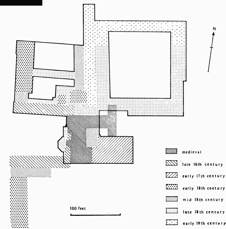
Plan of Hinton House showing its development. The outline is that of the mid 19th century.
Soane's plans provided for the demolition of everything on the south side of the old western court and the creation of a new stable court, incorporating a riding-house, to the north-east of the house, which balances in the southern elevation the remodelled kitchen court. Both ranges have two storeys above basements, sashed windows, and embattled parapets, and are partly faced in stone carved to resemble cobbling. (fn. 112) The west front of the hall range was to be demolished and replaced by a central octagonal entrance hall with a staircase on the south; the 18th-century stair was to be removed and the space it occupied used to enlarge the hall. The work was started in 1797 and Soane's designs were followed closely although a surveyor called Felton was employed to supervise the work, and Soane's plans of that year for remodelling the south front (fn. 113) were not adopted. No other designs for decoration at Hinton by Soane survive and it is probable that he had ceased to be Poulett's architect before the work had progressed that far.
By 1801 James Wyatt was working at the house (fn. 114) and the interiors of the new work, which are mostly in a flat Gothic style, are probably by him. He also prepared designs for a new entrance hall which would approach the centre of the house from the north along the open passage between the kitchen and stable courts, (fn. 115) but this had not been built by 1812 when J. Kemshead produced alternative designs. (fn. 116) The surviving entrance with its Gothic porte cochère may have been by (Sir) Jeffry Wyatt (Wyatville). (fn. 117)
These were probably the last major alterations to the house until its sale and division from the late 1960s into small houses, beginning with the stable court. Many new floors, doorways, and walls were inserted and formerly blind windows were opened, but the general appearance of the exterior was preserved.
In 1303 Walter de Stoke was returned as owner of land in Hinton under the Earl Marshal, (fn. 118) and by 1316 he was succeeded by Richard de Clare. (fn. 119) No location of the estate was given, though its later descent makes clear that it probably centred on the hamlet of Craft or Hintonscraft. Forde abbey had become owner of property there in the later 13th century, and the confirmation of its title by Hamon and later (1317) by William Denebaud suggests that the land had originally come from their estates. (fn. 120) The origin of Walter de Stoke's holding is not known, though he is probably the Walter son of Luke de Stoke who conveyed some meadow to Master Richard de Clare, clerk, in 1320; (fn. 121) and the same Walter who, after Richard, was given a life interest in a substantial property in Hinton and 'Northcraft by Crewkerne', by John de Carent in 1324. (fn. 122) Richard de Clare's interest continued until 1325. (fn. 123)
By that time the Carent family had established themselves. In 1343 William, son and heir of William Carent, occupied the estate. (fn. 124) He died in 1346 leaving a young son, also William, and an estate of 74 a. and rents. (fn. 125) Though not described as a manor, courts were evidently held. William, the son and heir, died c. 1422. Succeeding members of the family had their principal residence at Toomer in Henstridge, but continued in possession of the estate at Craft until 1560, when Leonard Carent of Winterbourne Gunner (Wilts.), a younger son of Sir William Carent of Toomer, sold it to Sir Hugh Poulett for £160. (fn. 126)
A second estate was held by the Warre family. In 1320 a Matthew Warre first occurs as a witness to a grant in Hinton. (fn. 127) By 1327 he was one of the most substantial taxpayers in the parish. (fn. 128) A William Warre had a small holding on the Carent estate, (fn. 129) and a possible successor, John Warre, died in 1349 in occupation of 1 a. held of William Carent's heir, 6 a. of the countess marshal, and 4 virgates of Thomas Denebaud, later described as 76 a. of arable and 3 a. of meadow and pasture. (fn. 130) Richard, his son, proved his age and succeeded in 1368, (fn. 131) and was still in occupation in 1399. (fn. 132) The property then descended to John Warre of Hestercombe, and thence to his son Richard (d. 1465) (fn. 133) and to his grandson Sir Richard (d. c. 1482). (fn. 134) On the death of Sir Richard's widow Joan in 1499 the property passed to Sir Richard Warre of Chipley (d. 1532). (fn. 135) The estate in 1499 was described as the manor of CRAFTEWARRE, held of Sir Amias Poulett by unknown service. (fn. 136) Thomas Warre of Hestercombe, who succeeded his father Richard, died ten years later. (fn. 137) His son Richard sold the estate to Sir Hugh Poulett in 1568 for £80. (fn. 138)
At his death in 1334 Henry le Guldene held some 50 a. of land at Hentonescraft, most of it as tenant of Thomas Denebaud though 10 a. of Alan de Cudworth. (fn. 139) Much of this estate seems to have been accumulated from 1324 onwards. (fn. 140) It descended to Alan's son Alan, then a minor. (fn. 141) This Alan died in 1361 leaving part of his property to his daughter Avice (d. 1420), wife of Stephen Derby. (fn. 142) Their son Robert died without issue in 1421–2. (fn. 143) In 1466 land in Hentonescraft was settled on William Cowdrey and his wife Avice, daughter of Joan the sister and heir of Thomas Gulden. (fn. 144) Cowdrey was followed by his son William (d. 1498), whose heir was his son Morgan, a minor. The property, including land in Dorset, was for a time in the hands of Morgan's stepfather, Sir Morgan Kidwelly (d. 1505). (fn. 145) The later descent of the property has not been traced.
About 1220 Robert de Barnevill granted the church of Hinton to St. Bartholomew's hospital, London. (fn. 146) On 1 August in that same year the hospital acquired a share of the tithes and the site for a barn. (fn. 147) In 1341 a house and 4 a. of land were added. (fn. 148) By the 16th century the estate of the 'Fryerney' had been modified: it then comprised half the tithe corn of the parish, the site of a barn, 1 a. of arable, and 3 a. of meadow. (fn. 149)
Under an agreement made in 1546 the Crown in 1547 granted to the City of London the rectory and advowson of Hinton, with right to appropriate. (fn. 150) The revival of St. Bartholomew's hospital and the previous grant to Sir Hugh Poulett of the advowson nullified the arrangement and the hospital continued in occupation of a share of tithes and the land, though Sir Amias Poulett apparently leased the holding from c. 1582. (fn. 151) His successors certainly farmed the tithes from the 1670s, and in 1699 Lord Poulett leased a parcel of ground measuring 43 ft. by 18 ft. called 'the Fryerny of George Hinton . . . whereon one thatched tenement lately stood'. (fn. 152) By 1848 the hospital's land was 'blended with the estate of the lessee', (fn. 153) and it was sold to Earl Poulett in 1869. (fn. 154)
In 1227 Thomas le Ostricer sold to the prior of Monkton Farleigh (Wilts.) ½ virgate in the parish. (fn. 155) In 1492 the then prior granted the reversion of the tenancy held by John Draper to Sir Amias Poulett. (fn. 156) In 1525–6 and at the dissolution of the priory in 1536 the value of the property, in the second year described as a messuage, was 10s. (fn. 157) Charles Blount, Lord Mountjoy, had licence in 1545 to alienate the holding, lately occupied by Sir Amias Poulett, to his successor Sir Hugh Poulett. (fn. 158) It was then presumably absorbed into the Poulett estates.
ECONOMIC HISTORY.
In 1086 the estate at Hinton was assessed for 13 hides, with land for 12 ploughs. The demesne farm measured 5 hides, with 4 ploughs, and was worked by 5 serfs; 16 villeins and 24 bordars worked the remainder with 10 ploughs. The demesne farm supported 36 head of cattle, 44 swine, and 190 sheep, there were 60 a. of meadow, and woodland measuring a league by half a league. Since 1066 the value of the estate had risen from £12 to £15. (fn. 159)
By the mid 14th century, when the holding was divided between the Carents and the Denebauds, a three-field pattern of open-field agriculture is revealed comprising North, West, and South fields, meadow land in the north of the parish, and pasture and woodland in the south. The Carent demesne estate in 1347 comprised just over 60 a. of arable, 9½ a. of meadow, 4 a. of separable pasture, and a small piece of oak wood. West field was then under wheat and rye, North field under oats and beans, and South field partly fallow and partly newlybroken, though there was a small plot there 'which can be sown each year'. Other areas of pasture could be sold 'when the fields in which they lie are opened'. There were 21 tenants on the Carent estate, with holdings varying in size between ½ virgate and ¼ messuage in return for suit of court, heriots, and commuted works, together with 4 nativi holding bondage land but paying cash for rents and works. (fn. 160)
A survey of the Denebaud estate in 1362 reveals a similar general pattern. There were 180 a. of arable, of which two-thirds were sown each year; 20 a. of grassland in severalty for hay and thereafter in common, common of pasture worth 12s., and some additional pasturage, together with a little wood. The manor complex was not described, but there were 2 dovecots, and 2 gardens were worth little in that year because the apple trees had been blown down. (fn. 161) A much greater manor complex was described in 1387 when Margaret Denebaud was assigned 75 a. of arable, 10 a. of meadow, and quantities of pasture and wood as her dower. (fn. 162)
From the 16th century onwards the economy was dominated by the expansion of the Poulett estate through the absorption of medieval freeholdings and the consolidation of the demesne, against a background of inclosure which by 1600 and probably some years earlier had brought open-field arable cultivation to an end, leaving only the three common meadows, Honeymead, Broadmead, and Westmead, under ancient usage. (fn. 163) Purchase of the Craft estates of the Warres and the Carents was accompanied in the 1560s by the disappearance of other free tenants of the manor, the Gerards and the Estmonds, also holders in Craft. (fn. 164) Exchanges of land between the lord and his tenants allowed the lord to consolidate holdings in Eastmead and also around Craft, one tenant at Craft receiving licence to inclose and another having pasturage for oxen and cows in the park in lieu of a better settlement. (fn. 165) The open East (formerly South) and North fields were only small closes by 1569, though there was still open arable at Berdon, possibly once part of South field, in 1560. (fn. 166) Evidence in a court case referring to people coming from the meadows 'a milking' provides a rare glimpse of farming practice. (fn. 167)
Accounts of the Poulett estate in the early 1650s (fn. 168) refer to the purchase of cattle at Chard fair, of sheep from the fair at Martinstown, now Winterborne St. Martin (Dors.), and of horses from Wales, and of the sale of fat cattle in London. The demesne flock was 150 sheep and 26 lambs in 1652; 2 cwt. of cherry trees were brought from London in the same year, and turkeys were among the livestock on the estate. Much hay was made in the park and harvest in 1652 and other years demanded 2 dozen pairs of gloves for the reapers. Canvas was bought in 1652 for a winnowing fan. A carrier living in the village in 1635 (fn. 169) travelled to London each week until the 1650s, (fn. 170) and a Hounslow waggoner was buried there in 1636. (fn. 171) In the 1670s Hinton was the scene of at least one petty sessional meeting. (fn. 172)
Important features of 18th-century Hinton are the disappearance of copyholds, the gradual development of consolidated tenant holdings, and extensions to the park. In the late 17th century there were just under 30 copyholds in the manor and just under 50 held by lease. (fn. 173) Conversion of all to leaseholds had been accomplished by 1796. (fn. 174) Eight tenant holdings were of 30 a. and more, the largest being the 64-a. farm of Bernard Hutchins (d. 1728), who by 1715 had increased his holding to over 100 a. (fn. 175) Some of the same land formed part of a similar holding amassed by Colonel John Helliar in the second half of the century, probably based on Manor Farm, (fn. 176) and by his death in 1792 it amounted to over 250 a. (fn. 177) Both men were closely connected with the Pouletts: Hutchins left some of his freehold property outside Hinton to Vere Poulett and Helliar served as Earl Poulett's steward. (fn. 178)
In 1765 there were only 6 tenant farms of over 30 a., and two years later two of these had disappeared. (fn. 179) Among the smaller ones was the Home Tenement, later known as the Priory, a copyhold property traceable from the 1650s when it was held by the Prowse family. (fn. 180) More small holdings were absorbed as the Pouletts extended their park. New areas had been added at least since the mid 17th century, (fn. 181) but between 1765 and 1773 Earl Poulett's holding in the parish increased from 824 a. to 904 a.; (fn. 182) by 1839 that part of the park in Hinton was 753 a., more than half the earl's holding of 1,215 a. in the whole parish. (fn. 183) Small holdings in Craft were gradually taken in hand throughout the century so that by 1780 a considerable part of the hamlet had evidently disappeared, though even so late as 1800 several of its small closes remained. (fn. 184) The surviving dwellings formed the nucleus of the farm known by 1819 as Brown's and later as Croft farm. The largest and oldest house, evidently the only one to survive, was by 1968 known as Oaklands and formed part of Hinton Park farm. (fn. 185) Extensions of the park northwards and westwards were made with little or no disturbance of dwellings in 1766 (fn. 186) and again in the late 1790s, though several roads were realigned or even abandoned. Landscaping and planting in connexion with these works continued until at least 1817. (fn. 187)
Details of farming practice and of other employment in the 18th century are scarce. The park itself was not exclusively ornamental: the old Park was divided for convenient letting in 1744, (fn. 188) Colonel Helliar kept cattle there in the 1780s, (fn. 189) and in 1783 a dairyman leased 21 milking cows and a dairy house at Craft for a year, with the right to graze the after grass on the lawn next to the Old Park and in other nearby fields. He was to receive feed for 11 calves, take 315 faggots, and have all the milk and the calves for a rent of £110 5s. (fn. 190) Just over 27 a. of common meadow survived at Westmead until 1793. (fn. 191)
References in the 17th century to flax, flax yarn, hemp, and looms, to a flaxdresser in 1682, and to a worsted comber in the 1690s suggest the presence of some cloth manufacture, (fn. 192) and 'linmen' occur c. 1760 and just after the turn of the century. (fn. 193) A family of mercers occupied the Priory from 1687. (fn. 194) There is otherwise the usual collection of plumber, maltster, blacksmith, tailor, and carpenter, with such additions as cooks, gardeners, and a barber who owed much of their livelihood to employment in the Poulett household and estate. There was also at least one shop. Three men from London settled in Hinton or acquired holdings there at the end of the century: John Healy, a City silk merchant, leased the Home Tenement from 1780, Joseph Rendall left his trade as a paper-stainer in Soho to become a yeoman farmer in 1783, and John Donne, a nurseryman from Millbank, Westminster, leased houses and a field in 1800. (fn. 195)
Whether as a direct result of the expansion of the park into Craft or of a general population increase, cottages were put up in some numbers from the 1740s, mostly on the green at the east end of the village in addition to those already standing around its edge. (fn. 196) At least three dwellings were built on the waste elsewhere in 1812, a house and five cottages went up in 1814, and a block of four tenements became six dwellings in 1818, all largely through the enterprise of Thomas Beagley, Earl Poulett's steward. (fn. 197)
In the mid 18th century the manorial rents of Hinton amounted to less than £44. (fn. 198) By 1819–20, after the complete conversion to leaseholds, the sum had increased to £643. (fn. 199) The death in 1792 of the estate steward provided the opportunity to rearrange farming units. (fn. 200) Three substantial holdings, Brown's, Lodge, and Poulett's farms, were created by 1825, the second mostly outside the parish but including much of the park. (fn. 201) Brown's, later Croft, farm, with 372 a., was the largest unit in 1839, followed by the present Manor farm (153 a.) and Lodge farm (133 a. in the parish). Of these only Manor farm-house stood in the village along with the smaller but longer-established holdings of Old, Tett's, Priory, and Bicknell's (later Brown's) farms. (fn. 202) By 1851 the larger farms had increased in size: Croft farm was 407 a. with 11 labourers, Manor farm 350 a. with 13 labourers, Lodge farm 280 a. with 12 labourers, and Samuel Palmer's farm 100 a. with 8 labourers. Bridge farm had emerged with 27 a. (fn. 203) A century later, when the Poulett estate was sold, some significant changes had taken place. Croft and Lodge farms had been joined to create Hinton Park farm with 713 a.; Manor farm had been divided and the older 'village' farms were again revived, sometimes with land at a distance from the farm buildings and in more than one block. There were thus 6 farms measuring between 122 a. and 56 a. in size. (fn. 204) By this time Earl Poulett owned virtually the whole of the parish.
Tithe accounts of the early 19th century suggest a preponderance of arable not borne out by the tithe award of 1839, but probably the result of the large number of moduses by then negotiated. Of the arable crops c. 1819 wheat predominated, followed by potatoes, barley, and turnips. Beans, clover, vetches, flax, and hemp were cultivated in smaller quantities. The cider tithe in 1819 amounted to 256 hogsheads; and in 1834 as many as 23 a. of flax were grown. (fn. 205) In 1905 permanent grass covered 594 a., arable 249 a., and woodland 111 a. (fn. 206) Since 1968 much of the wood has been felled, and farming is mixed.
About half the population was engaged in agriculture in 1821, (fn. 207) and Hinton House and estate gave employment to many. Some thirty people were normally employed on the home farm and grounds c. 1806–8, increased to over forty during harvest. (fn. 208) The domestic staff in 1837 totalled 24 and the garden employed a further ten. (fn. 209) In 1851 as many as 22 people were resident in the house including the earl and his family. (fn. 210) Among trades practised in the village in the mid 19th century, 44 women and girls took in gloving, a common occupation of the poor in the area; but the presence of 14 dressmakers, 7 tailors, and 2 milliners reflects the importance of Hinton House to the village economy. The prosperity of the parish is also suggested by the appearance of villa residences. Hinton's 'pleasing air of comfort and respectability' in 1840 was conveyed as much by these dwellings as by its 2 inns and 8 shops, including a bookseller and stationer; and it was an eminently suitable base for Messrs. Guy and Stubbs, land surveyors, whose clerk Benjamin Love, the son of a local carpenter and later occupant of one of the villas, was by 1883 steward of large estates in Wiltshire and Hampshire as well as a land agent with much local business. (fn. 211)
During the two World Wars Hinton House was requisitioned: in the 1914–18 war it became a military hospital and from 1939 to 1945 it was occupied by two girls' schools. Its sale and subsequent conversion into many dwellings from c. 1970 has ensured that 'comfort and respectability' characterized the community in the 1970s. The estate itself was sold in two parts. Most of the Poulett holding in the parish, apart from the mansion, the former park, and a few houses, was sold in 1941 to the University of Oxford, and was subsequently dispersed in 1958. (fn. 212) The remainder of the property was sold by Earl Poulett in 1968. (fn. 213)
In 1632 John, Lord Poulett, was licensed to have two annual fairs at Hinton, one on St. George's day (23 April) and the morrow, and one on 14 and 15 September. (fn. 214) No further trace of the September fair has been found, but the Spring fair, where lemons and figs were purchased in 1654, (fn. 215) continued until c. 1947. (fn. 216) At the beginning of the 20th century cattle and sheep were sold in High Street and amusement stalls stood at the Cross and in Church Street. In 1912 the fair moved to the field by the Rectory. (fn. 217) Cattle continued to be sold at least until 1933. (fn. 218) In the 1930s there remained the memory of a June 'gooseberry' fair. (fn. 219)
There were two mills at Hinton in 1086, worth 7s. 6d. (fn. 220) By 1347 a mill called 'Dounemill' belonged to the Carent estate, (fn. 221) and perhaps stood near Craft. There was also a mill on the Denebaud estate, worth 30s. in 1362. (fn. 222) A mill occurs in 1552, occupied by the Baily family. (fn. 223) From 1678 Hinton mill, standing just in Hinton parish but near the village of Lopen and driven by Lopen brook, has a continuous history as part of the Poulett estate, almost certainly in succession to the Denebaud holding. From that time at least until 1796 it was occupied by members of the Cable family. (fn. 224) By 1866 the occupiers were spinning and weaving flax for sailcloth, but had evidently ceased production by 1883. (fn. 225) In 1958 the mill-house, an early-19th-century brick-fronted building, was part of a small holding. (fn. 226)
LOCAL GOVERNMENT.
Court rolls for the manor of Hinton survive intermittently for the period 1523 to 1561 and are complete for the decade after 1563. (fn. 227) There are court books for the whole Poulett estate for 1651–77, 1679, 1703–10, and 1715–27. (fn. 228) Extracts survive for 1685, 1706, 1716, 1726, 1737, and 1786. (fn. 229) A list of fourteen 'tithing houses or plots', drawn up at the Michaelmas court in 1814, indicates the regular appointment of tithingmen until 1838. (fn. 230) Sessions were described either as 'manor courts' or 'manor courts leet' in the 16th century, though the 17th- and 18th-century extracts are from courts baron. In the 16th century the court met twice a year, in spring and autumn, and in the 17th and 18th centuries once; no place of meeting is known. (fn. 231) The only regular officer of the court seems to have been the hayward, chosen each year in the autumn in regular rotation. In 1569 two men were chosen as surveyors of the highways. To the usual concerns about strays, under-tenants, broken hedges, and blocked ditches were added in the 1560s orders for the provision of 'mantells' or chimneys in houses and 'stercovers' in barns. (fn. 232) A dangerous dog was reported in 1523. (fn. 233)
A court was held on the Carent estate in the 14th century. Only one roll has survived, when the property was in Crown hands in 1347, (fn. 234) but tenants in 1343 and 1388 held land by suit twice a year. (fn. 235) Both a reeve and a bailiff were mentioned in 1347. (fn. 236)
From the 17th century the offices of churchwarden and overseer were filled by rotation in respect of holdings. Accounts survive from 1633. (fn. 237) A parish constable occurs by 1640 and two surveyors of highways in 1636 and regularly from 1658. (fn. 238) Highway accounts exist for the periods 1693–1774 and 1803–32. (fn. 239) In 1639 the parishioners agreed to a monthly vestry meeting 'for ordering and setting right of parish business'. (fn. 240) From the 1660s onwards a group of six or eight men with the rector signed the overseers' accounts and evidently conducted most of the parish business, 'nominating and appointing' the wardens and 'nominating' the overseers. (fn. 241) In the 18th century often only one warden was chosen, and the number of signatories to the accounts varied more widely. Parish meetings were held in one or other of the village inns in the 1680s and 1690s, (fn. 242) and in the 18th and 19th centuries were followed by dinners.
By the 1670s the overseers were contributing towards house repairs, rent, nursing, boarding out children, apprentices, and clothing, the money raised not only by rates but by the rent of a garden, the sale of apples growing in a marlpit, and sundry gifts. From 1697 none was to have relief 'but those who come publicly to the church and make their condition known'. (fn. 243) Paupers continued to wear badges at least until 1790. (fn. 244) Cottages in various parts of the village were rented from 1693 to house the poor, and in the late 1780s one of these stood at Pithill. (fn. 245) Cottages continued to be rented for the poor from Earl Poulett until the parish became part of the Chard poor-law union in 1836. (fn. 246) At the same time the rents of other paupers were paid in increasing sums.
The prosperity of the parish permitted the overseers to exercise unusual generosity. Special cash grants were made during the hard winter of 1691–2; a cot was given for a young boy in 1715; a flax shop was repaired for a distempered woman in 1726. Much money was spent on medical attention including treatment for eyes at Salisbury in 1678–9 and travel to hospital in Bridgwater in 1831–2. Paupers were first inoculated in 1772 and an apothecary was permanently retained for their care from 1787. Work was provided on parish roads in the early 19th century, and in the 1830s 'engines' were purchased 'for the use of those who wish to learn gloving'. Two men were assisted in their passage to Newfoundland in 1830. (fn. 247)
The overseers also maintained a round house or lock-up which in 1830 was used to store a pauper's goods and two years later held the pauper herself. (fn. 248) The building stands on the green.
The waywardens were particularly active in the early 19th century when parish paupers were employed on the roads. Earl Poulett, owner of all the local quarries, was nominated for office as waywarden each year between 1808 and 1832, often accompanied by his bailiff. (fn. 249)
CHURCH.
The benefice of Hinton is a rectory, though from the early 13th century a proportion of the tithes was appropriated. Before 1 August 1220 Robert de Barnevill, describing himself as patron, granted the church of Hinton 'so far as pertains to a lay person' to St. Bartholomew's hospital, London, 'towards the maintenance of priests there ministering'. (fn. 250) By another charter Robert granted the patronage to the preceptor of St. Bartholomew's. (fn. 251) The patronage was then granted by the preceptor to Jocelin, bishop of Bath, (fn. 252) who, perhaps in exchange, on 1 August 1220 gave to the hospital the tithe of sheaves 'of the church estate (de dominica ecclesie)', half the tithe of all other sheaves belonging to the church, all the tithe hay from Robert de Barnevill's demesne, and 2 a. of land for the site of a barn. (fn. 253)
The patronage was exercised by successive bishops, or by the Crown during vacancies, (fn. 254) until it was transferred to Sir Hugh Poulett on the ground that the advowson had once belonged to the manor 'but had come into the hands of the bishops of Bath and Wells by lapse and had been in their possession a long time'. (fn. 255) The patronage descended through successive members of the Poulett family until the death of the 8th earl in 1973.
The benefice was valued in 1291 at £6 13s. 4d. (fn. 256) In 1532 the rectorial income was said to be £10, and in 1535 £13 13s. 3d. (fn. 257) About 1668 its reputed value was £100, (fn. 258) and in 1831 the net income was £197. (fn. 259) The gross income in 1851 was £214. (fn. 260)
The tithes granted to St. Bartholomew's hospital in 1220 and apparently assessed in 1336 at £13 6s. 8d. (fn. 261) were reckoned by the time of Sir Hugh Poulett (d. 1573) as half the tithe corn of the parish; (fn. 262) and this remained the hospital's share in the 17th century. (fn. 263) The rector's tithe was worth over £5 12s. 6d. in 1535. (fn. 264) Lord Poulett was evidently leasing the tithes of the hospital by 1672, and the total value of tithes 'due to Earl Poulett' in the early 19th century varied between £150 in 1810 and £189 10s. 9d. in 1819. (fn. 265) A rent-charge of £171 for the rector's share and £60 for St. Bartholomew's share was agreed in 1839, the latter in respect of 360 a. of arable. (fn. 266)
By 1839 a wide variety of moduses was payable: 3d. for each cow, a shoulder of veal for every calf killed in the owner's house, a tithe of the sale price of weaned calves, ½d. for reared calves, 1d. for colts, 3d. an acre for ancient meadow, 1d. for gardens, and eggs at Easter. A modus of £6 10s. covered the tithes for most of the park and 6s. 8d. was paid for the mill.
The rectorial glebe was worth less than £3 in 1535. (fn. 267) Evidence produced in 1635 claimed that 'within the memory of man' over 40 a. had been alienated, resulting in the extinction of many of the families of those responsible, (fn. 268) and the glebe terrier of 1626, listing 14 a. of arable, 1 a. of meadow, and the first share of a further acre, included none of the alienated land. (fn. 269) In 1839 the area of glebe was nearly 15 a. (fn. 270) All this had been sold by 1975. (fn. 271)
Among the properties of the benefice alienated before 1635 and presumably before 1626 was the 'ancient parsonage house' and the site of the parson's pigeon house. (fn. 272) In 1626 the parsonage house was described as adjoining the churchyard. Near it was an outhouse 'called a kitchen, with a loft over it'. (fn. 273) There were also two barns, one nearby and the other in the middle of the village. (fn. 274) This substantial house, having seven hearths in 1664, (fn. 275) was found to be insecure, and in 1839 it was demolished and the present house was built 'nearly on the site' of the old, with an enlarged garden, stable, and coachhouse. (fn. 276) It was completed in 1841 and is a substantial Ham stone structure decorated with simple pilasters.
Several of the medieval rectors had interests outside the parish. Master William le Mercer, rector by 1311 to 1321 and evidently an Irishman, became dean of Dunwich in 1321; (fn. 277) Thomas Foston was licensed in 1402 to study for two years at the request of the abbot of Leicester; (fn. 278) and John Marsley, rector 1435–9, was a member of Bishop Stafford's household. (fn. 279) There was both a curate and a chantry chaplain in 1532. (fn. 280) John Poulett, rector 1552–68 and a younger son of the patron, held three benefices and lived in Jersey, where the Pouletts governed. (fn. 281) Edmund Peacham, rector 1587–1614, was imprisoned in the Tower for libelling Bishop Montagu before the High Commission, and was later deprived of his orders and found guilty of treason in 1615. (fn. 282) Under Richard Gove, rector from 1618, Holy Communion was celebrated frequently, as many as nine times in a year including four times around Easter, the vestry in 1639 levying a rate of 2d. from every communicant to pay for the bread and wine. (fn. 283) The Communion table was railed in 1635–6, and a rate was levied to buy an organ two years later. (fn. 284) Gove was ejected from the living c. 1650, and was replaced by Presbyterian ministers (fn. 285) under whom in 1665 the wardens were described as 'ruling elders of Hinton Church'. (fn. 286) By the 1670s Communion was celebrated only four times a year. (fn. 287)
The rectors during the 18th century were normally resident, though from 1779 they held the livings of Seavington St. Michael and Dinnington. (fn. 288) In 1776 there were c. 20 communicants. (fn. 289) Henry Stambury, rector 1789–1838, took two services each Sunday by 1815, with monthly celebrations of Holy Communion. (fn. 290) In 1851 the estimated congregation was 450 in the morning, including 100 Sundayschool children, 520 in the afternoon with 120 children, and 150 at the evening Sunday school. (fn. 291) By 1870 Sunday services were held in the morning and evening, both with sermon, and celebrations on the first Sunday in each month and at the chief festivals. (fn. 292) From 1913 the benefice was held with Dinnington. (fn. 293)
Nothing is known of a chantry beyond the existence of a chantry priest in 1532. (fn. 294)
The church of ST. GEORGE, so dedicated by the early 13th century, (fn. 295) was apparently consecrated on 6 February in an unknown year. (fn. 296) It is of Ham stone and comprises a chancel with north vestry and chapel, a nave with north transept forming the Poulett pew, connected with the north chapel, a south aisle and south porch, and a western tower. Masons' marks on the fabric date from the earlier 13th century and are identical with some found at Wells cathedral, (fn. 297) though the main details of the fabric are of the 15th and 16th centuries. The font was originally in a plain 13th-century style, but decoration was added in the mid 15th century, incorporating the Poulett arms. The tower was evidently planned or under construction in 1486. (fn. 298)
The north transept was remodelled c. 1814 by James Wyatt to create a private pew above the Poulett vault. (fn. 299) Pew and chapel together contain family monuments dating from that of Sir Amias Poulett (d. 1538), and including that of his grandson Sir Amias (d. 1588), removed from St. Martinin-the-Fields, London, in 1728. (fn. 300) Earlier monuments elsewhere in the church include a tomb-chest at the entrance to the former transept, with a figure of an armoured knight, assigned in the 17th century to an unknown member of the Denebaud family, (fn. 301) and a late-15th-century brass of John Chudderle and his wife. (fn. 302)
At least until 1812 the vestry room was an area formed by a screen across the eastern end of the chancel, with entrance doors at each side of the altar. (fn. 303) This room had been repaired and the pulpit and 'reading seat' moved in 1790. (fn. 304) A vestry was added on the north side of the chancel in 1815, its entrance from the church being an adapted window embrasure. (fn. 305) Much of the furniture in the church dates from 1903 and 1924; the pulpit was erected in 1912 and the pews in 1924. (fn. 306) The royal arms in Coade stone, by Coade and Sealy of London, are dated 1812. The armorial glass in the church in the 1640s has disappeared. (fn. 307) Mural monuments in the nave and aisle include several to members of the Poulett family and their retainers of the 18th and 19th centuries. The gilded weathercock on the top of the tower stair turret was made by Thomas Bayley of Bridgwater in 1756. (fn. 308)
There are six bells: (i) 1922, Taylor of Loughborough; (ii) 1828, Kingston of Bridgwater; (iii) 1756, Bayley, Street, and Co., Bridgwater; (iv) 1624, Wiseman of Montacute; (v) 1783, Davis; (vi) 1624, Wiseman. (fn. 309) The plate comprises a cup of 1815 and paten and plate of 1813. (fn. 310) These replaced a chalice and plate given by Anne, Lady Poulett, in 1665 and a silver tankard acquired in exchange for an old silver chalice and cover in 1689. (fn. 311) The registers date from 1632, though there is a gap between 1647 and the appointment of a parish register in 1653. (fn. 312)
NONCONFORMITY.
A group of Presbyterians was meeting in a house under the leadership of John Langdale, ejected minister of Cricket St. Thomas, in 1673. (fn. 313) A house was licensed for use in 1811. (fn. 314) Bible Christians visited the village in 1824; a preacher addressed 'about 200' but was then arrested. (fn. 315) A room was licensed in 1845, with no denomination specified. (fn. 316) It may have been either for Wesleyan Methodists or for Brethren, both of whom were established by 1851. A Wesleyan group was formed by 1843 and had a membership of 11 in 1849 and 18 in 1864. (fn. 317) In 1851 it still met in a private room, and its evening congregation was 20 strong. (fn. 318) No separate chapel was erected, but services continued in premises in Teapot Lane, later South Street, until shortly before 1926. (fn. 319)
By 1851 a cottage was being used by the Brethren, who held services for 30 on Sunday afternoons under the leadership of a 'minister' from Merriott. (fn. 320) A chapel was built on the north side of High Street by Dr. Newberry, son of a former rector. (fn. 321) It is a plain building of Ham stone with a tiled roof, and was described as new in 1875. (fn. 322) It was closed c. 1972. (fn. 323)
There is a tradition of a meeting-house on the green, closed before the end of the 19th century. (fn. 324) It may be connected with followers of Joanna Southcott who are said to have worshipped in the parish. (fn. 325)
EDUCATION.
In 1818 it was reported that a school had been established by Earl Poulett's ancestors; 10 boys were then taught free by a master paid by the family and provided with a house. Other children, presumably boys, were received at the school on payment of 3d. weekly. (fn. 326) It is not known how long this school had existed. Henry Cuff (b. 1563) is said to have been taught at a grammar school in the village; (fn. 327) there was certainly a schoolmaster there by 1642–3, and in 1652 a woman was paid by Lord Poulett for teaching a pauper child. (fn. 328) Barnaby Hanning of Hinton was described as a schoolmaster in 1742, (fn. 329) and 10 boys were being taught in the parish in 1786, possibly under the terms of a will of 1733. (fn. 330)
A charity school for boys and girls, possibly the same as the foregoing, is recorded in 1776. (fn. 331) From 1797 until 1823 the salaried assistant overseer was paid for instructing poor children in the catechism on Sundays. (fn. 332) Several schools were established in the 1820s and 1830s providing instruction at parents' expense: two for infants taking 16 boys and 12 girls; two day-schools for 30 boys and 15 girls; and a boarding school for 14 girls, possibly the one said to have been housed at the Priory. (fn. 333) By 1825 there was a Sunday school for 20 boys and 20 girls. (fn. 334) Another, started in 1831 and supported by the National Society and by subscription, was held in a room in the churchyard opened in 1833. (fn. 335) By 1835 it had 20 boys and 40 girls, and was still open in 1840. (fn. 336) By 1840 there were at least two private schools, one for boys, the other for girls either daily or boarding. (fn. 337) At least one private school continued until the 1880s. (fn. 338)
In 1850 the present school, affiliated to the National Society, was settled in trust by Earl Poulett. (fn. 339) It was supported in the late 19th century by grants, by a voluntary rate, and by local efforts. It had accommodation for 228 children, though average attendance was less than half that number. (fn. 340) During the 20th century attendances fell, standing at 52 in 1946. In 1949 the school accepted voluntary controlled status, and from 1972 took children only from the 5–9 age range, the older pupils travelling to schools in Crewkerne. In 1975 there were 54 children on the register. (fn. 341) Hinton St. George First School stands on the south side of West Street. It is a substantial Ham stone building with a tiled roof, providing in 1903 two classrooms and a house for the teacher. A distinguishing feature is a slim bellcot surmounted by a cross.
CHARITIES FOR THE POOR.
An alms-house had been established by 1636, (fn. 342) housing 4 people who received 10d. a week. (fn. 343) Under the will of the first Lord Poulett (d. 1649) additional lodgings were to be built to bring the total of inmates to 6, each to receive 12d. a week and a frieze gown once a year. (fn. 344) During the 1650s 8 inmates received 12d. a week, and each year kersey and blue baize. (fn. 345) The number of occupiers was increased to 10 by John, 4th Earl Poulett (d. 1819), but the 5th earl reduced it to nine. (fn. 346)
In 1823 it was reported that the establishment was 'scarcely' a regular alms-house, but comprised 'little tenements close together' of which the Pouletts 'granted a permissive occupation from time to time, according to their pleasure'. Each occupier then received 12d. a week and a serge coat or gown each Whitsunday. (fn. 347) In 1872 the present alms-houses were erected in Back Lane by Lady Augusta Poulett on land given by her nephew, the 6th earl, (fn. 348) and until her death in 1888 the earl continued to pay each occupier 12d. a week, though gowns were no longer supplied. The previous houses, apparently standing by the church path off West Street, were abandoned. (fn. 349)
Lady Augusta Poulett also bequeathed £1,000 for the benefit of the alms-house people, increasing their pay to 2s. a week. The two charities were consolidated under a Scheme of 1911, creating the Poulett Alms-house Charity, with trustees who included the owner of the Poulett estate. Nine alms-people were to be chosen from residents of good character. The income of £52 14s. 8d. from investments was to provide not less than 2s. weekly pay for each inmate. (fn. 350)
By 1950 Chard rural district council was renting 7 of the dwellings, but under a Scheme of 1964 2 representatives of the Local Authority and Earl Poulett or his nominee became the sole trustees. (fn. 351) The premises were later modernized, and the occupants have since contributed towards the loans raised for the purpose. (fn. 352)
The alms-house, of local stone, occupies three sides of a grassed quadrangle on the north side of Back Lane, providing 9 single-storeyed dwellings.
By will dated 1728 Bernard Hutchins gave a rentcharge of £41 12s. on land at Hill in Chillington to provide 2s. weekly, on Mondays, for eight poor families to be chosen by Lord Hinton or his heirs (as owners of the land thereafter) or by the rector, churchwardens, and overseers. (fn. 353) The terms of the bequest were carried out by successive earls until the early 19th century. By 1823, however, payment was made on Wednesdays, and from 1817 onwards was made to 32 people each month, 8 each week. (fn. 354)
Under a Scheme of 1928 the charity was placed under the administration of the Poulett Alms-house trustees, its terms to be the original weekly distribution to 8 poor families. (fn. 355) This Scheme was amended in 1967 to give the benefit to the poor in general but especially to poor residents of Hinton. (fn. 356)
Colonel John Helliar (d. 1792) devised land in Merriott, the rent to be distributed on St. Thomas's Day (21 Dec.) in shoes and stockings for poor children. (fn. 357) In 1967 the income of £12 bought 6 pairs of shoes. In 1975 the charity was similarly distributed in shoes. (fn. 358)
Richard Bicknell (d. 1822) bequeathed £50 in trust to provide bread for the poor on Old Christmas Day (6 Jan.). In 1970 there was an income of £1 5s., and in 1976 it was distributed in half loaves of bread to the elderly. (fn. 359)
Thomas Beagley (d. 1826) bequeathed the interest on £500 to be given in blankets on 14 January each year. In 1974 the income of £10.85 was distributed in blankets. (fn. 360)