A History of the County of Somerset: Volume 6, Andersfield, Cannington, and North Petherton Hundreds (Bridgwater and Neighbouring Parishes). Originally published by Victoria County History, London, 1992.
This free content was digitised by double rekeying. All rights reserved.
'Over Stowey', in A History of the County of Somerset: Volume 6, Andersfield, Cannington, and North Petherton Hundreds (Bridgwater and Neighbouring Parishes), (London, 1992) pp. 158-162. British History Online https://www.british-history.ac.uk/vch/som/vol6/pp158-162 [accessed 19 April 2024]
OVER STOWEY
Over Stowey 1838
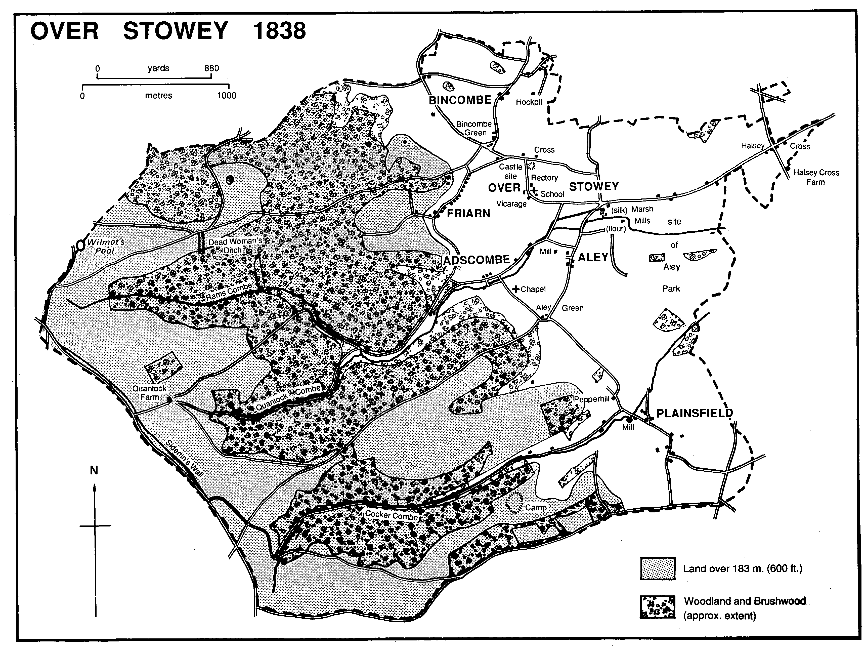
The parish of Over Stowey, also called Upper Stowey, (fn. 1) lies on the heavily wooded eastern side of the Quantocks immediately south-west of Nether Stowey and c. 12 km. west of Bridgwater. It is roughly rectangular in shape, extending for 5 km. from east to west and 3.5 km. from north to south. The western boundary follows the Quantock ridgeway and the southern a road from the ridgeway to Spaxton. The northern boundary reaches the southern side of Nether Stowey castle. (fn. 2) Land at Stowey Rocks (2 houses, 11 persons) was transferred to Nether Stowey in 1886, and the total area was 3,697 a. in 1891. (fn. 3) There have been no later changes and in 1981 the parish covered 1,496 ha. (fn. 4)
Most of the parish lies on the higher slopes of the Quantock ridge, the land falling eastwards from 350m. on the summit to 91m. on the eastern boundary. The slope is pierced by a succession of steep-sided combes, Bin Combe in the north, Rams Combe and Quantock Combe joining together in the centre, and Cockercombe in the south. (fn. 5)
Most of the higher ground comprises Hangman grits, with Upper Keuper marls and valley gravels lower down the slopes. At the junction of grits and marls are areas of sandstone, Ilfracombe slates with grits and limestones, and a small pocket of Schalstein. (fn. 6) Stone was quarried for building by 1614 (fn. 7) and in the 19th century there were quarries at Adscombe and 0.5 km. south of Adscombe. The second produced green igneous rock used in the construction of Quantock Lodge. (fn. 8) Road stone was extracted at Bincombe by the mid 19th century (fn. 9) and limestone was dug for burning by the later 17th on Aley manor and elsewhere. (fn. 10) Malachite was said to have been found at Pepperhill quarry c. 1920. (fn. 11)
Copper is said to have been extracted at Bincombe between 1690 and 1724, (fn. 12) and licences to mine on Aley manor, possibly in Aisholt parish, were granted in 1716 and 1720. (fn. 13) Other licences were granted in 1755 and 1758 to mine on Friarn manor in Bincombe, and a mine there, possibly on Dodington manor lands, was operating near Walford's Gibbet by 1790. (fn. 14)
Several barrows and cairns, the linear earthwork known as Dead Woman's Ditch, a small iron-age enclosure called Cockercombe or Plainsfield camp, and traces of a group of huts at the head of Rams Combe are evidence of the prehistoric exploitation of the Quantock ridge within the parish. (fn. 15) The claim that weapons and burials were discovered near Plainsfield and that they marked the site of an early Saxon battle has not been substantiated, although a field called Deadman's field there might seem to give colour to the story. (fn. 16)
The limited area of level ground in the parish dictated the pattern of medieval settlement. With one exception, dwellings were in small clusters at the mouth of each combe. The exception is the hamlet of Over Stowey, which lies on a small spur commanding an extensive view of the coast and the Parrett. It included by the later 12th century both the parish church and the 'old castle precinct' on the Stowey 'herpath'. (fn. 17) The castle may have been the caput of the estate of Alfred d'Epaignes at Stowey in the later 11th century and the precursor of the castle at Nether Stowey. (fn. 18) It survives as a large, flat mound to the north of Over Stowey village. Aley and Plainsfield hamlets were recorded in 1086, (fn. 19) Adscombe in the 13th century, (fn. 20) and Bincombe in 1327. (fn. 21) Adscombe in 1547 comprised only two houses and a ruined tenement. (fn. 22) The settlement called Peppestake (later Pepperhill) was recorded in 1316 (fn. 23) and Hockpit or Hogpit by 1655. (fn. 24) Building on roadside waste was widespread in the 18th and 19th centuries at Friarn, Bincombe Green, and along the road eastward from Marsh Mills to Halsey Cross, although some of the cottages did not stand for long. (fn. 25) In the 20th century permanent camping sites were established near Rams Combe.
At least four ancient routes run beside or across the parish. The most significant at an early date was the Anglo-Saxon 'herpath' or military road, which gave the parish its name. (fn. 26) The 'herpath' followed a roughly east-west route, entering the parish at Halsey Cross on the eastern boundary, skirting the castle north of Over Stowey hamlet, (fn. 27) and running directly up a great spur to Dead Woman's Ditch and thence to Crowcombe Gate on the Quantock ridgeway. (fn. 28) A second east-west route branched south-west from the 'herpath' east of Over Stowey hamlet and passed through Aley Green, a route known in the 12th century as the great way of Solmere. (fn. 29) The second route may later have been diverted southwest from Aley Green to the Triscombe stone on the ridgeway and thence to Taunton. (fn. 30) There were also two north-south routes. The Quantock ridgeway, known as Alferode in 1314, (fn. 31) continued to be used until the beginning of the 19th century when the lower routes were impassable. (fn. 32) The second, largely abandoned in the 19th century, ran south from Nether Stowey castle, and where it crossed the 'herpath' by Over Stowey castle gave its name to a holding called Cross. It ran through Over Stowey hamlet and Aley Green to Plainsfield. A bridge was built c. 1640 at Rooksford, where the route crossed the Seven Wells stream, which runs down through Adscombe. (fn. 33) The part of the route between Nether Stowey and Cross and known as Millers Lane had been abandoned by 1782. (fn. 34) A route further east between Plainsfield and Halsey Cross had probably been abandoned by 1838 (fn. 35) and before 1842 was replaced by a more direct route north between Plainsfield and Marsh Mills. (fn. 36) Those changes were probably connected with the improvement of the Quantock estate culminating in the building of Quantock Lodge, the disappearance of Aley Green, and the closure of other routes within the newly created grounds. The road from Aley to Triscombe, for example, was closed in 1864, and in 1877 that from Adscombe through Seven Wells to Quantock Farm was declared private. (fn. 37)
The high ground to the west and north-west, shared in the early Middle Ages between the honors or lordships of Stogursey and Nether Stowey, (fn. 38) seems to have been part of a pre-Conquest forest of Quantock. (fn. 39) The Stogursey share, c. 1,000 a. stretching south-east along the ridge from West Hill above Rams Combe, was partly open ground and was common to the tenants of Wick manor in Stogursey until the 17th century. (fn. 40) In the 1630s at least 180 a., part of Plainsfield Hill and presumably the ground later known as Aisholt Hill or the Slades, (fn. 41) was divided and allotted in fee to local landowners including the lord of Plainsfield, in return for the surrender of their claims to common over the whole area. (fn. 42) By 1683, and probably by 1656, about half the remainder of the Stogursey land had been inclosed and let, and Quantock farm was created soon after 1686. The owner, Robert Siderfin, probably built the wall which marked the western boundary of both the farm and the parish. (fn. 43)
The Nether Stowey share, known as the Stowey Customs and covering Robin Upright's Hill and Great Bear, (fn. 44) remains largely uninclosed, although Warren House, recorded in 1672, (fn. 45) had become the centre of a small farm by 1838. (fn. 46) Attempts to inclose the area in the 1800s led to disputes between the lord of Nether Stowey and the vicar of Over Stowey, the latter claiming the right to cut wood there. (fn. 47) The assumed transfer of ownership of the soil of the commons from the honor to the manor of Nether Stowey in the early 17th century seems to have given rise to the claims of tenants of that manor to commons there. In the later 20th century the parish councils of Over and Nether Stowey registered rights to estovers, turbary, and bracken cutting on behalf of all householders in their parishes. (fn. 48)
In 1086 Aley and Plainsfield had 25 a. of woodland and the Stowey estate wood measuring 1½ league square. (fn. 49) Woodland belonging to the rectory on the lower slopes had largely disappeared by 1655 and what remained was scrub rather than timber. (fn. 50) Friarn wood was said to cover 220 a. in the mid 17th century, but 46 a. had been 'lately grubbed up' by 1688 and the remainder was coppice. (fn. 51) At about the same time half of the newly created Quantock farm was woodland fit for sale. (fn. 52) In 1739 only half Parsonage wood was actually timbered and the trees, six years old or less, were decayed. (fn. 53) Fifty years later most of the woodland on Quantock farm was said to be suitable only for oak coppice. (fn. 54) The sale of part of the Enmore estate to Henry Labouchere in 1833 brought together some 660 a. of woodland, of which 4 a. was fir plantation and the remainder oak coppice. (fn. 55) In addition there were similar woodlands on the Stowey Customs further north. In 1838 about 900 a. were under wood, mostly oak coppice, (fn. 56) but by the 1880s firs had been planted widely on the Quantock estate, (fn. 57) a policy which the Forestry Commission continued in the 20th century despite local protest. (fn. 58) In 1905 there were 920 a. of woodland in the parish. (fn. 59) Clear felling took place during the First World War but replanting began in 1922. (fn. 60) The hills remained extensively wooded and in 1986 were used both for recreation and for commercial purposes.
Aley park measured 100 a. in 1275 (fn. 61) and occupied land east of Aley hamlet, probably as far as the eastern boundary of the parish. In 1357 at least 36 people were accused of breaking into it, hunting deer, and killing a foal and cattle grazing there. (fn. 62) Throughout the 15th century the pale was regularly repaired and the deer were fed as necessary. (fn. 63) By the early 17th century the park had been divided. (fn. 64) West of Bincombe in Nether Stowey lordship the names Warren House and Great and Little Warren suggest the site of a warren established after the grant of free warren to Philip de Columbers in 1248. It is possible also that the Nether Stowey deer park extended into Over Stowey in the north-east corner of the parish. (fn. 65)
There was a tavern at Aley in 1201 (fn. 66) and a victualler was recorded in the early 17th century. (fn. 67) In 1673 the keeper of a licensed alehouse in the parish offered no lodging, sold beer during service time, and allowed cards. (fn. 68) In 1676 four victuallers lost their licences. (fn. 69) In 1686 the parish had one inn offering two beds and stabling, (fn. 70) but three years later there were five licensed houses. By 1690 the number had been reduced to four and by 1736 to two. (fn. 71) One of them may have been the Squirrel inn at the junction of Rams Combe and Quantock Combe. (fn. 72) The Dial at Aley Green and the White Horse on the Bridgwater road served the parish in the 18th century. The latter was last licensed in 1779 (fn. 73) and later became a farmhouse with the same name. The Dial, later the Aley Green public house, was briefly closed c. 1800 (fn. 74) but remained until 1851 when it was probably demolished during the building of Quantock Lodge. (fn. 75) It was replaced by a beerhouse at Halsey Cross, licensed in 1849, which later became the Albion and in 1881 the Pear Tree inn. (fn. 76) It appears to have closed by 1894. (fn. 77) There is said to have been a public house at Bincombe, probably in the early 19th century. (fn. 78)
A reading room and news room with a library of 150 books was established in 1896; it appears to have closed c. 1925. (fn. 79) There was a cricket club in the parish between 1897 and 1902. (fn. 80)
There were 115 adult males in the parish in 1641 (fn. 81) and in 1801 the population was 468. It had risen to 592 by 1831 but had fallen to 561 in 1851. The increase to 613 in 1861 was due in part to the staff of Quantock Lodge and the estate, but the total declined steadily thereafter to 433 in 1891. The establishment of a hospital and later a school at Quantock Lodge led to an increase in the 20th century, and the total was 511 in 1971. the normally resident population in 1981 was 360, many of them probably living in the north where new housing in Nether Stowey village extended over the parish boundary. (fn. 82)
In 1645 the rectory and probably the church tower were fortified for the king by the Selleck family (fn. 83) and in 1668 a local man was pensioned for injury in the king's service. (fn. 84) Christopher Rich (1647-1714), attorney and theatrical manager, and the Revd. John Poole (d. 1857) were born in Over Stowey. (fn. 85) Henry Labouchere (cr. Baron Taunton 1859, d. 1869), the builder of Quantock Lodge, was M.P. for Taunton 1830- 59 and a cabinet minister. (fn. 86)