A History of the County of Somerset: Volume 6, Andersfield, Cannington, and North Petherton Hundreds (Bridgwater and Neighbouring Parishes). Originally published by Victoria County History, London, 1992.
This free content was digitised by double rekeying. All rights reserved.
A P Baggs, M C Siraut, 'Pawlett', in A History of the County of Somerset: Volume 6, Andersfield, Cannington, and North Petherton Hundreds (Bridgwater and Neighbouring Parishes), ed. R W Dunning, C R Elrington (London, 1992), British History Online https://www.british-history.ac.uk/vch/som/vol6/pp267-268 [accessed 30 April 2025].
A P Baggs, M C Siraut, 'Pawlett', in A History of the County of Somerset: Volume 6, Andersfield, Cannington, and North Petherton Hundreds (Bridgwater and Neighbouring Parishes). Edited by R W Dunning, C R Elrington (London, 1992), British History Online, accessed April 30, 2025, https://www.british-history.ac.uk/vch/som/vol6/pp267-268.
A P Baggs, M C Siraut. "Pawlett". A History of the County of Somerset: Volume 6, Andersfield, Cannington, and North Petherton Hundreds (Bridgwater and Neighbouring Parishes). Ed. R W Dunning, C R Elrington (London, 1992), British History Online. Web. 30 April 2025. https://www.british-history.ac.uk/vch/som/vol6/pp267-268.
PAWLETT
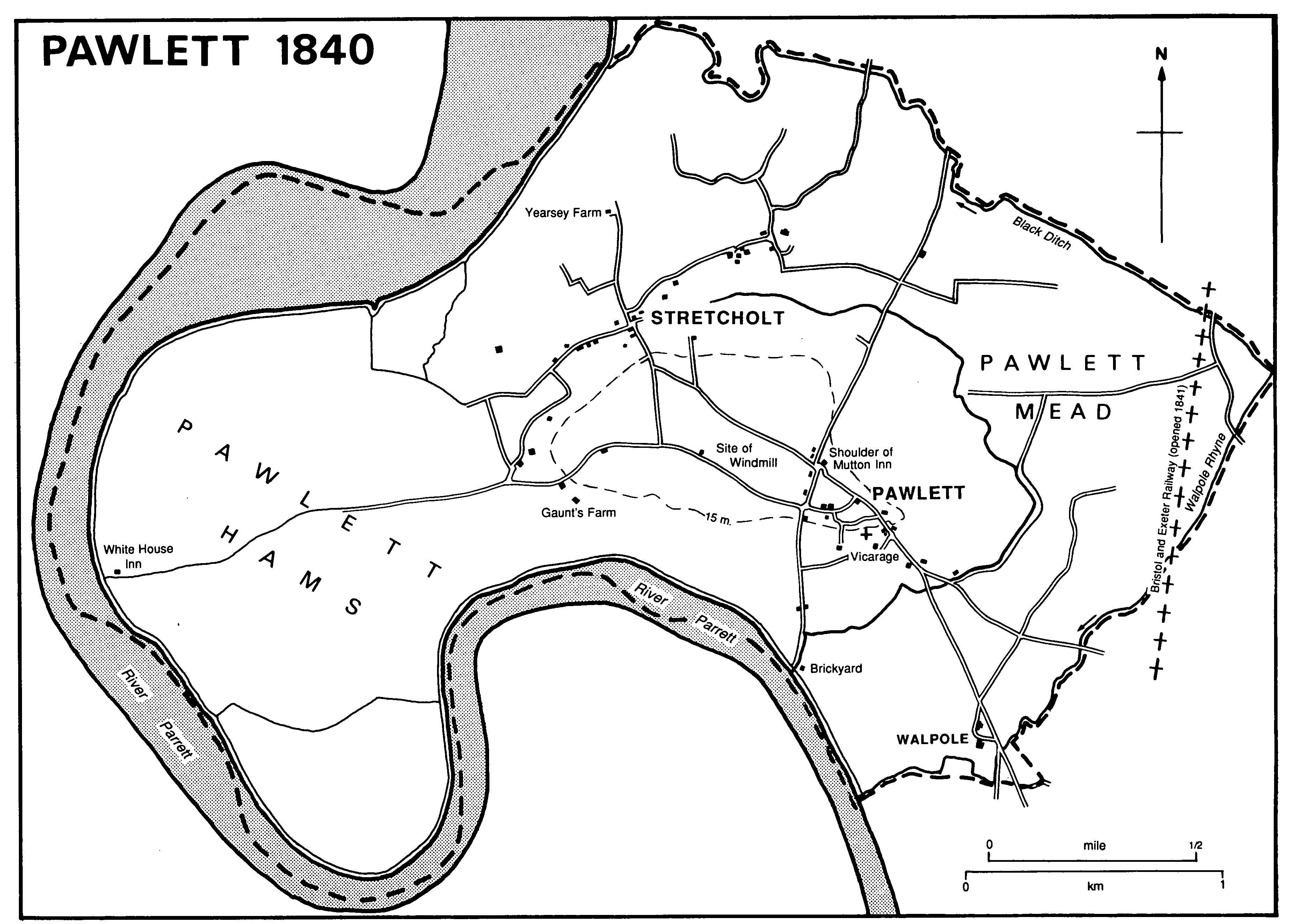
Pawlett 1840
Pawlett parish lies north of Bridgwater in a bend of the river Parrett near its mouth. The river confines the parish on the west, and on the north-east and south-east the boundary follows the Black Ditch and Walpole Rhyne respectively. From north to south the parish measures 3 km.; from east to west 5.5 km. Its area is 1,258 ha. (3,108 a.). (fn. 1) At its centre is Pawlett Hill, on which Pawlett village stands. On lower ground are Stretcholt hamlet to the north and Walpole hamlet to the south.
Pawlett Hill rises to 32 m. above sea level, an outcrop of Lower Lias clay and limestone forming a detached part of the Polden ridge; it is surrounded by low-lying alluvium, marine sands, and Burtle beds. Walpole Rhyne and the Black Ditch may represent an earlier course of the Parrett, which on its present course has moved its banks, sometimes naturally, sometimes in association with man-made banks and drains. (fn. 2) The name Walpole refers to a pool or pill (creek) associated with a sea wall. (fn. 3) All the land within the meander enclosing the west side of the parish may have been reclaimed from saltmarsh, probably beginning in the 13th century. Gaunts Farm, south of Pawlett Hill and below the 15-m. contour, and Yearsey Farm, on the marshes west of Stretcholt, seem to mark the progress of land reclamation in the 18th century. (fn. 4)
A bronze palstave is said to have been found near Stretcholt. Pawlett Hill has yielded evidence of occupation from the Roman period, and there may have been a Saxon site in Pawlett Hams. (fn. 5)
Pawlett village, the name of which was that of an 11th-century estate (fn. 6) and may refer to a stream either with stakes or below a steep-sided hill, (fn. 7) stands at the south-east end of Pawlett Hill and consisted until the 19th century of a few stone farmhouses and irregular closes in a triangle of roads with the church in the southeast angle. Along the north-eastern side of the village Puriton Way ran from the pound at the top of the hill to Bourdon or Bourne Green at its foot. West from the green ran Burham Lane, and south from the pound ran Canham Lane, formerly the way to Pawlett pill. (fn. 8) Pawlett village later expanded west and north-west along the hill top, and much of the historic centre was infilled, partly with local authority housing and largely in brick. Stretcholt and Walpole were also the names of 11th-century estates. (fn. 9) Stretcholt is a road-side settlement along the probable course of the Saxon 'herpath'. (fn. 10) Walpole hamlet was partly destroyed by the building of the new road to Bridgwater in 1821-2. (fn. 11) In the mid 20th century it became the site of a fuel distribution depot. (fn. 12)
The name Stretcholt suggests that the area was anciently wooded, and coppicing was practised at Stretcholt in the later 18th century. (fn. 13) There were 12 a. of coppice in 1838. (fn. 14) There was a warren on Pawlett Gaunt's manor in 1477. (fn. 15)
Before the 18th century the main route through the parish was that which came from the north through Stretcholt and across the Hams to the river crossing opposite Combwich. The route was regarded as the king's highway by the 15th century. (fn. 16) A second route from the north to Pawlett village was causewayed and crossed the watercourse, later known as Brickyard Rhyne, by Queen Bridge, recorded in 1497. (fn. 17) A route from the east along the Polden ridge divided at Pawlett village; both branches joined the road to the river crossing in the mid 17th century. (fn. 18) The roads north and east of the village were turnpiked in 1759 to form part of the Bristol-Bridgwater road which was rerouted through Walpole in 1822. (fn. 19) The ferry, known as Combwich Passage or White House Passage, was shared between the owners of Pawlett Gaunt's manor and the Combwich manors in 1589, (fn. 20) and in 1810 a half share was let with the inn at the passage. (fn. 21)
A landing place called Pawlett pill, directly south of Pawlett village, was regarded as a creek within the port of Bridgwater by the 15th century. (fn. 22) Tenants of Pawlett Gaunt's manor were obliged to scour the pill in 1475. (fn. 23) It continued in use in the 18th century (fn. 24) but by 1780 (fn. 25) it was blocked by Canham sluice and a landing stage on the river had evidently been constructed. (fn. 26) That wharf was rebuilt and probably extended when bricks were manufactured nearby in the 19th century. (fn. 27)
The Bristol and Exeter railway, opened in 1841, passed through the eastern corner of the parish. (fn. 28)
There was a victualler in the parish in 1609 (fn. 29) and from 1655 the house at Combwich Passage later known as the White House was licensed. (fn. 30) In 1675 there were four victuallers, but later normally two. (fn. 31) The White House remained in business until 1897 and survived as a farmhouse until 1920 or later. (fn. 32) The Shoulder of Mutton, in Pawlett village and so called by 1779, (fn. 33) was built probably c. 1658. (fn. 34) It remained open until 1883 (fn. 35) and in 1986 was known as Nevys House. A third inn was licensed c. 1740, (fn. 36) and a public house called the Jolly Sailor is said to have been at Stretcholt in the 19th century. (fn. 37) The house called the Manor House became a hotel c. 1950 (fn. 38) and was in business in 1986.
The Pawlett friendly society, established in 1794 and reorganized in 1838, met at the Shoulder of Mutton in 1844. (fn. 39) In the early 20th century there were refreshment rooms and a social club in the village, and in 1935 a tennis club. (fn. 40)
In 1801 the population was 429, rising to 433 in 1811 and to 529 in 1821 when there were only 69 houses for 98 families. Numbers peaked at 597 in 1871 but fell from 483 in 1891 to 346 in 1901. The population thereafter increased to 374 in 1911, 462 in 1931, 672 in 1961, and 786 in 1981. (fn. 41)
Twenty-six men were fined for involvement in the Cornish rebellion in 1497. (fn. 42) Two men from Pawlett were implicated in the Monmouth rebellion, one of whom was transported to the West Indies. (fn. 43) About 1940 trials for cutting the cables of balloons were held over the Hams; the balloon was housed in a hangar which still stands north-west of Gaunt's Farm. (fn. 44)