A History of the County of Somerset: Volume 7, Bruton, Horethorne and Norton Ferris Hundreds. Originally published by Victoria County History, London, 1999.
This free content was digitised by double rekeying. All rights reserved.
'Milton Clevedon', in A History of the County of Somerset: Volume 7, Bruton, Horethorne and Norton Ferris Hundreds, (London, 1999) pp. 42-50. British History Online https://www.british-history.ac.uk/vch/som/vol7/pp42-50 [accessed 11 April 2024]
In this section
MILTON CLEVEDON
The parish of Milton Clevedon, taking its suffix from its medieval owners, (fn. 1) lies between the town of Bruton 3 km. to the south-east and Evercreech on the opposite side of the river Alham. It comprises two areas, each roughly triangular, straddling a ridge of which the highest point is 199 m. (653 ft.) on the north-east side of Creech Hill. From the ridge both areas fall to watercourses, to the Alham on the Evercreech boundary to the north-west and to the Coombe brook on the Bruton boundary to the south-east. A tributary of the Alham and a lane form the boundary with Batcombe. Roads delineate parts of the boundary with Ditcheat and Lamyatt, including a Roman road from the Foss Way, now marked by a footpath and a watercourse, on the south-west. (fn. 2) The parish measures 502 ha. (1,241 a.). (fn. 3)
The south-eastern part of the parish rises from 80 m. (262 ft.) in the Coombe valley over bands of Midford Sands and Inferior Oolite limestone to 170 m. (558 ft.) on the road over Creech Hill.
The main area of the parish falls from 199 m. (653 ft.) on Creech Hill over bands of Inferior Oolite, Midford Sands, Middle Lias silts and sands, Lower Lias clay, and river deposits to 50 m. (164 ft.) beside the Alham. (fn. 4)
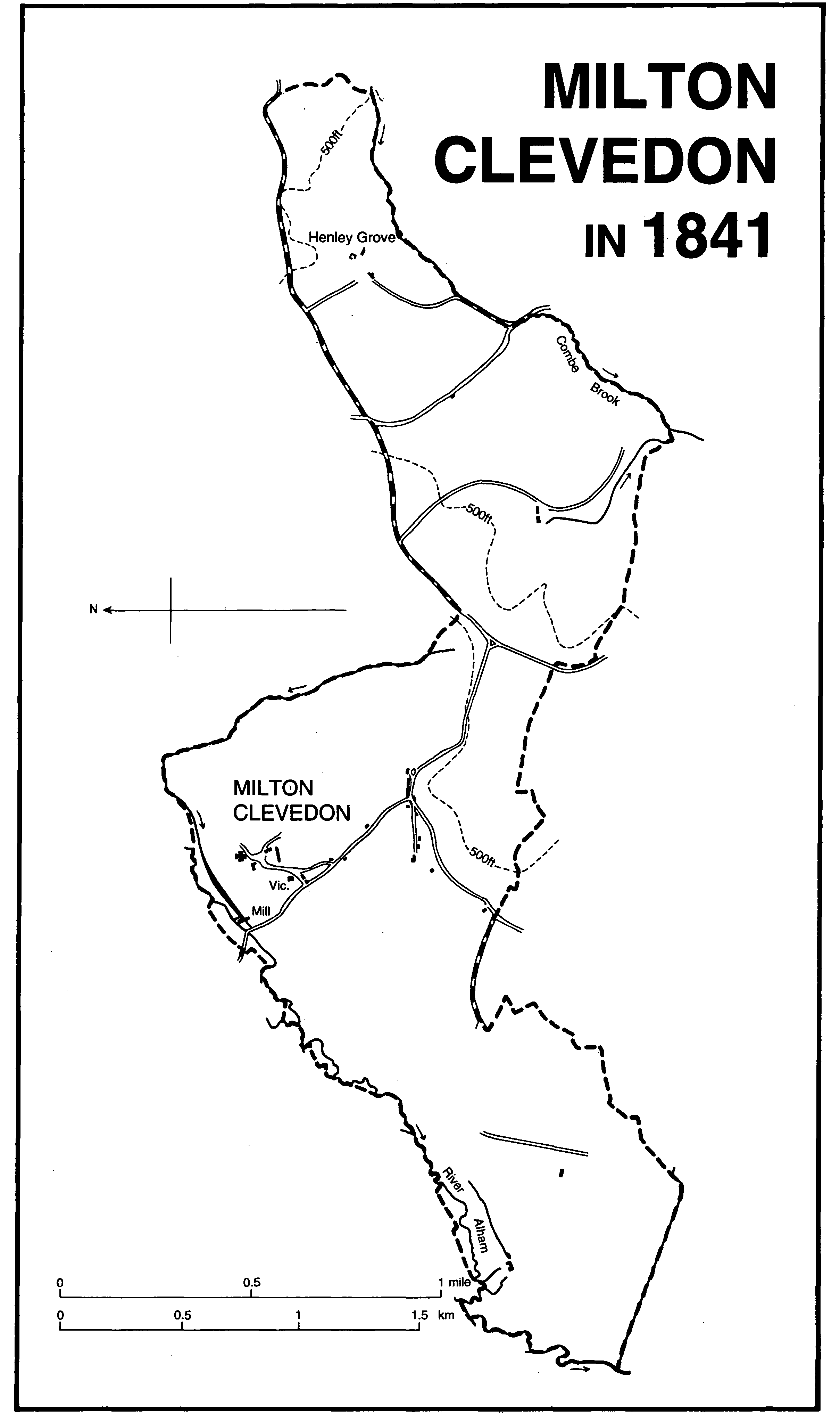
Milton Clevedon in 1841
By the 18th century the Evercreech-Bruton road seems to have been the principal route in the parish. It crosses the Alham by Milton bridge, mentioned as Golafre Bridge in the 1540s, (fn. 5) and on the top of Creech Hill meets a road to Brewham which crosses the road from Batcombe to Bruton, known as the Portway, (fn. 6) at Hedgestocks. All those roads were turnpiked in 1756 by the Bruton trust and gates were set up at Creech Hill and at Hedgestocks, on the parish boundary. (fn. 7) Earlier routes from the centre of the parish may be traced running near the church towards Stoney Stratton and Spargrove. (fn. 8)
An early Iron-Age earthwork, probably a stock enclosure but known as the Castle, occupies a spur of Creech Hill overlooking the Alham valley. The site includes a possible barrow on the west. (fn. 9) Apart from a few isolated farmsteads, settlement was in three areas: around the church and manor house in the north, (fn. 10) at Hengrove, now Henley Grove farm, in the east, mentioned in 1243, (fn. 11) and around the road junction at the centre of the parish, known as Milton cross, where roads from Evercreech, Lamyatt, and Bruton meet. In the Middle Ages the last settlement stretched along the Lamyatt road to the parish boundary at Cold Harbour and also beside the lane to Milton farm. (fn. 12) Hengrove had shrunk to a single farm by the later 17th century but three decayed tofts were then recorded there. (fn. 13)
There was common arable until the 17th century near the village and until the 18th at Hengrove. (fn. 14) Milton wood may be that recorded in 1086. (fn. 15)
There was one licensed victualler from 1731 to 1787 but none in 1788. (fn. 16) A beerhouse in 1841 had become the Ilchester Arms by 1861. (fn. 17) It remained open in 1995.
There were 84 taxpayers in the parish in 1641. (fn. 18) In 1801 the population was 206, but fell to 189 in 1821. It rose to a peak of 242 in 1831 but thereafter declined steadily, to 145 in 1901, to 91 in 1961, and to 60 in 1991. (fn. 19)
MANOR AND OTHER ESTATES.
MIDDLETON, later MILTON, was held by Ulward in 1066 and by Ildebert of Matthew de Mortain in 1086. (fn. 20) By 1166 overlordship had passed to Henry Lovel (fn. 21) and continued to be held of the honor of Castle Cary until 1723 or later. (fn. 22) A chief rent was owed to the lord of Castle Cary in 1632 (fn. 23) and was paid until 1723 or later. (fn. 24)
In 1066 the terre tenancy was held by William de Clevedon. (fn. 25) The manor passed to John de Clevedon and to John's son Matthew. (fn. 26) That or another Matthew was alive in 1243 (fn. 27) and by 1275 had been succeeded by Raymond de Clevedon. (fn. 28) By 1284-5 the manor had passed to John de Clevedon, possibly a younger son, who died before 1303 when his son (Sir) John was a minor. (fn. 29) Sir John died in 1336 and the manor was held by his widow Emme or Emmeline until c. 1347 (fn. 30) when it passed to Sir John's son Sir Edmund (d. 1376). Sir Edmund was succeeded by his grandson Edmund Hogshawe, a minor. (fn. 31) Edmund died while still under age in 1388 when his heirs were his sisters Joan and Margaret. (fn. 32) Milton passed to Joan and to her husband Thomas Lovel and he held by curtesy until his death in 1401. (fn. 33) Thomas Lovel, son and heir of Thomas and Joan, married Agnes or Alice, daughter of John Rogers of Bridport. (fn. 34) Thomas and Alice had two daughters, Margery, wife of Edward Hull, and Agnes, wife of Thomas Wake. (fn. 35) Rogers, who had been granted wardship of the manor after 1406, (fn. 36) held it for life from 1431 with successive remainders to his two granddaughters. (fn. 37) He died in 1441 and Margery and Edward Hull (K.G. 1453, d. 1453) took possession. (fn. 38) They were childless and in 1478-9 Milton was settled on Roger Wake, grandson of Agnes Wake. (fn. 39) In 1483 Roger conveyed the manor in trust for his wife Elizabeth for life with remainder to his younger son John, (fn. 40) but following Roger's attainder in 1485 the forfeited manor was granted in 1486 to Sir John Fortescu. (fn. 41) Sir John was later said to hold the manor in trust and after Roger's death in 1504 (fn. 42) his widow Elizabeth held it. In 1507 Elizabeth and her sons Thomas and John sold the manor to Simon Green. (fn. 43)
Simon Green was succeeded in 1509 (fn. 44) in the direct male line by William (d. 1545) (fn. 45) and Matthew (d. 1578). (fn. 46) Matthew's wife Catherine held the manor at her death in 1596. (fn. 47) Their son Bartholomew (d. 1602) (fn. 48) was succeeded by his son John. In 1632 John settled the manor on the marriage of his son Edmund and it was held for life by Edmund's father-in-law James Hodges (d. 1641). (fn. 49) In 1642 James's widow Frances and Edmund Green held jointly. (fn. 50) Edmund mortgaged the estate heavily in the 1650s (fn. 51) and in 1661 Edmund, with his son Edmund and his father John, sold the manor to Sir John Strangways (d. 1666). (fn. 52)
Sir John was succeeded by his son Giles who in 1674 gave Milton to his second son Thomas (d. 1713). (fn. 53) Thomas's son, also Thomas (d. 1726), left two sisters Elizabeth (d. 1729), wife of James, duke of Hamilton and Brandon, and Susanna (d. 1758), wife of Thomas Horner who took the additional name Strangways. Susanna's daughter Elizabeth married Stephen Fox (d. 1776) who also added the name Strangways and in 1741 was created Baron Strangways and in 1756 earl of Ilchester. (fn. 54) The manor descended with the earldom to Henry (d. 1802), Henry (d. 1858), William (d. 1865), Henry (d. 1905), and Giles, lord in 1939. (fn. 55)
The manor house was recorded in 1632 when John Green reserved for his own use the chambers over the kitchen and summer parlour. There was a dovecot. (fn. 56) The house was entirely rebuilt, south-west of the church, in brick and stone c. 1714 at a cost of £6,000, (fn. 57) probably for Susanna Strangways (d. 1718). About 1730 it was described as a 'handsome' mansion with 10 rooms on each floor. A stable for 20 horses, with a coachhouse, formed part of a courtyard walled in stone topped with 'handsome pallasadoes'. There was a large garden newly planted and a canal stocked with fish. (fn. 58) The house was boarded up in 1725 and the marble chimney piece in the hall was removed to Stinsford (Dors.) in the following year. (fn. 59) The building, whose rooms in 1755 still bore the names of the steward, the housekeeper, and the butler, was let (fn. 60) and came to be known as Great House Farm. (fn. 61) It was demolished before the end of the 18th century except for the stable. (fn. 62) The site became the farmyard of Manor Farm when the present house replaced the early 18th-century home farmhouse. Traces of the canal survive. (fn. 63)
Lands in Hengrove in Milton were held by Richard in the early 13th century and claimed by his son Elias in 1242-3; (fn. 64) by Adam Deneys in 1280, after forfeiture by Robert son of Richard; (fn. 65) and by Edward Stradling in 1318. (fn. 66) The Hengrove estate of Amice, widow of John Gregory (d. 1429), descended to her son Richard Weston before 1459. (fn. 67) In 1466 Richard gave Hengrove to trustees who in 1469 settled it on William Weston (fl. 1487). (fn. 68) By 1520 William had been succeeded by Henry Weston who held Hengrove of Milton manor by knight service. (fn. 69) By c. 1530 it had been given to the canons of Bruton and thereafter descended with Bruton manor until 1741. (fn. 70) Several exchanges of land took place between the owners of Bruton and Milton manors especially in 1731 to create a consolidated estate of 142 a. (fn. 71) The estate was acquired in the 18th century by James Harding (d. 1816) and descended in his family until the late 19th century. (fn. 72)
The house, known as Henley Grove Farmhouse, was rebuilt c. 1800 in stone rubble with a 3-bay ashlar frontage, having sash windows and a semicircular door head under a bracketed pediment.
Before 1300 the canons of Bruton held a 20s. rent charge on land, (fn. 73) later said to be for a wax candle in their church. After the Dissolution it was payable to the Crown by the lord of Milton. (fn. 74)
Milton church was given to the canons of Bruton in the later 12th century. (fn. 75) Part of the income supported a vicar. (fn. 76) By 1535 the canons were letting land and tithes. (fn. 77) In 1549 the Crown granted the whole RECTORY to Giles Kelway, (fn. 78) from whom it had passed by 1557 to William Hartgill. William was followed by his grandson Cuthbert Hartgill (fn. 79) who died in 1580 and was succeeded by his infant son John. In 1601 John sold it to John Still, bishop of Bath and Wells (d. 1608), for his son Thomas, then a minor. (fn. 80) In 1617 Thomas Still and his wife Bridget sold it to John Green. Ownership of the rectory thereafter descended with the manor (fn. 81) until 1842 when the great tithes were merged with the manor and Hengrove estates. (fn. 82)
ECONOMIC HISTORY.
In 1086 there were 6 ploughlands and 5 teams of which 2 were in demesne, worked by 4 servi; 9 villani and 9 bordars held the remainder. There was 24 a. of meadow. Livestock comprised 1 horse, 10 cattle, 18 pigs, 40 goats, and 160 sheep. The value of the estate had been £5 in 1066 and had increased to £6. (fn. 83)
Raymond de Clevedon is said to have had a warren in 1275. (fn. 84) In 1441 the demesne comprised 100 a. of arable, 16 a. of meadow, 40 a. of enclosed pasture, and a further 300 a., presumably on Creech Hill. The 40-a. wood was said to be worth nothing beyond the cost of maintaining the enclosure. (fn. 85) East and west fields were mentioned in the early 17th century. (fn. 86) Only Sheifurlong remained open in the west field by 1632. The east field was probably completely inclosed by the 1640s. (fn. 87) Milton down or Milton field near Hengrove, parts of which were known as the Vale of the White Horse and Snake Lake, was a much larger area of common arable shared between Bruton and Milton manors. Inclosures were made in the 17th and 18th centuries and the down was finally inclosed after exchanges in 1731 between the two manors. (fn. 88)
Milton hill, that part of Creech Hill in Milton Clevedon, was common pasture. (fn. 89) Pressure on grazing land appears to have been a dominant concern in the 16th and 17th centuries. In the mid 16th century there were several disputes between lord and tenants concerning common pasture on Milton hill. The common had formerly supported 1,300 sheep but the lord had overstocked and there was no grass left by Michaelmas. The tenants won their suit and were allowed to graze 32 sheep for every 'ferthing' of land; the lord was limited to 400 sheep and strangers were not allowed. (fn. 90) The problem was aggravated by the inclosure of 200 a. of Sheepsleight, possibly on Creech Hill, to form part of Milton farm before 1614. (fn. 91) Nevertheless in 1632 the manor court re-affirmed the common rights of tenants on Milton hill and on the down, east of Creech Hill, from harvest to Christmas eve and from 20 March until sowing although the 300 sheep of the farmer of the demesne were allowed on the land before those of the tenants and the summer herbage every alternate year belonged to the lord. Provision was made for drying sheep on the hill after washing. Areas of arable in the open fields were common pasture from the end of November for horses, rother beasts, or sheep. (fn. 92) In 1662, however, overstinting by both the lord and his tenants continued and the owners of 1,452 sheep were presented. (fn. 93)
In 1665 half the manor was described as demesne, divided into three farms, and most of the rest was leasehold for lives. Apart from the glebe there were only three other holdings over 30 a. Over half the 604 a. of demesne was pasture with 166 a. of arable and 121 a. of meadow. (fn. 94) In the later 17th century 60 a. of rough grazing on one farm was converted to arable in five years, increasing the value of the farm possibly by a quarter. That farm grew 70 a. of wheat, barley, and other grain in 1677 and supported 200 sheep. By 1694 it had again increased in value and in 1693 grew wheat (28 a.), barley (27 a.), oats (17 a.), peas (12 a.), vetches (3 a.), beans (2 a.), and a crop of turnips for sale. (fn. 95) Nevertheless most tenants still farmed common arable in Milton field until the 1730s and probably the main reason for exchanging land with Bruton manor in 1731 was to complete inclosure around Hengrove. (fn. 96) In the early 18th century French grass was sown on inclosed ground and a tenant in 1711 agreed not to break up the Great French grass ground, the first sown on his farm, and to sow a further 24 a. Where land was allowed to be broken fallow crops of rye grass and clover had to be used. (fn. 97) At the same time houses were taken down and others improved as holdings were re-arranged and enlarged and inclosures made. (fn. 98) In 1718 livestock on the home farm included carthorses, oxen, dairy cattle, cattle for fattening, 81 sheep, and 9 pigs. There were stocks of threshed and unthreshed grain and wool. (fn. 99) In the manor the same year new inclosures were recorded on Milton down laid to French grass but there remained 192 sheep commons with a further 200 on Milton hill. Within a few years those had been let with Greenscombe farm and in 1722 remained common only in alternate years. (fn. 100) There is no later record of common rights and by the 19th century the hill was in closes and partly arable. (fn. 101) There appears to have been a move from sheep to cattle during the 18th century: in 1730 one of the demesne farms was a dairy farm and another in 1755 included 16 dairy cows as well as 104 sheep, horses, cattle, and pigs. Several dairies and milkhouses were recorded. (fn. 102)
In 1086 10 furlongs of woodland were recorded. (fn. 103) In 1441 the demesne estate included 40 a. of wood, (fn. 104) almost certainly Milton wood which measured 33 a. in 1842. Field names indicate that it formerly extended east to the parish boundary. (fn. 105) The northern half of the wood was felled after 1905 but the rest survives. (fn. 106)
Milton wood may have produced the 104 bu. of charcoal burnt in 1726. (fn. 107) In 1730 the wood contained 633 young and thriving trees and underwood and there were 140 young trees around the manor house, the whole valued at over £2,600. (fn. 108) Milton wood was divided into sections each of which was sold for coppicing in different years. Two coal masters from Midsomer Norton bought a cut early in the 18th century and cuts of underwood and 15-year growth were made in the 1770s. In 1794 the timber was worth about half its value in 1730 and was mainly oak with ash and elm of various qualities and some fir, walnut, 'arbale', sycamore, chestnut, and lime. (fn. 109)
Further re-arrangement of the farms took place in 1768 when all the land west of the Evercreech-Bruton turnpike not let for lives was divided into four farms, (fn. 110) eliminating almost all the small tenements. In 1842 there were only 8 holdings in the whole parish over 10 a.; 3 under 50 a., 4 between 100 a. and 200 a., and Greenscombe farm (306 a.). About 300 a. in the whole parish was arable and 789 a. was under grass. There were small field gardens on the northeastern slopes of Creech Hill and a few withy beds. (fn. 111) Greenscombe farm increased to 600 a. by 1871, but was smaller in 1881. Between 1851 and 1871 there were four farms all over 100 a., employing 52 labourers in 1871, but only 34 in 1881. The lower land was given over to grass and 4-course arable was practised on the higher. Dairying continued to be important in the 19th century and in 1871 5 dairymen and women rented cows. (fn. 112) In the 1880s one dairywoman, Mrs. Cannon, devised a system of cheesemaking which was widely adopted. (fn. 113) Late 19th-century improvements included the use of Egyptian linseed and cotton seed, but the arable at Greenscombe farm was said to have been neglected. (fn. 114) By 1905 arable had been reduced to 232 a. and grass increased to 1,005 a. (fn. 115) In the 20th century the parish continued to be predominately grassland divided between the five large farms established by 1881. (fn. 116)
There may have been a fuller in the parish in 1327. (fn. 117) During the 17th century a woollen weaver, a linen weaver, a clothworker, and a worsted comber were recorded. (fn. 118) In 1821 only 26 out of 42 families were employed in agriculture and many women probably worked at the silk mill in Evercreech which continued to provide employment until the 1870s. (fn. 119)
Quarry ground was recorded in 1664. (fn. 120) There was a large limestone quarry on Creech Hill and a small quarry and kiln south-west of Henley Grove Farm in the later 19th century. (fn. 121) The field name Brickyard may be associated with the building of the early 18th-century mansion house. (fn. 122)
There were two resident, licensed surgeons in the mid 17th century. (fn. 123) A maltster was recorded in 1731 (fn. 124) and a shopkeeper between 1861 and 1883. (fn. 125) By 1947 there were neither shops nor services in the village. (fn. 126)
Mills.
There was a mill in 1086 (fn. 127) and in 1225. (fn. 128) In 1574 there were two mills, probably under one roof, known as Galofers or Gullofers mills, but one had decayed by 1610. (fn. 129) The mill belonged to the manor and in 1630 the lord agreed to have his household corn and malt ground there and allowed the miller fern and fuel. (fn. 130) The mill, which had two sets of stones, was rebuilt c. 1760 and stood beside Milton bridge on a millstream south of the Alham. (fn. 131) It went out of use after 1851 and had been demolished by 1885. (fn. 132) The house had been rebuilt by 1818 but was also demolished before 1885. (fn. 133)
LOCAL GOVERNMENT.
A court book for Milton manor survives for 1563-9 and presentments and extracts of court rolls for 1662-6, 1675-1711, and 1721-5. The court was concerned with the common fields and grazing, watercourses, defective buildings and ditches, roads, bridges, and rights of way. The court appointed a hayward. (fn. 134) The manor pound was mentioned between 1632 (fn. 135) and 1708. (fn. 136) Tenants of Bruton manor land in Milton owed harvest days and suit to Bruton court in the 17th century. (fn. 137)
There were two wardens and two overseers by 1674. (fn. 138) A parish constable was chosen in 1842. (fn. 139) There was said to be a parish poor house in 1619-20. (fn. 140) The parish held a cottage at Milton cross for the poor until 1730 or later. (fn. 141)
On 25 October 1809 on the occasion of the king's jubilee bread, cheese, beer, and coal were distributed to 21 families in the parish and 13 other families. In 1813 a reward for informing on a poacher was used to provide bread for the poor. (fn. 142)
In 1835 Milton Clevedon became part of Shepton Mallet poor-law union. In 1894 it formed part of Shepton Mallet rural district and in 1974 part of Mendip district. (fn. 143)
CHURCH.
There was a church at Milton by the 12th century. (fn. 144) The first known vicar was appointed in 1313. (fn. 145) The living was a sole benefice until 1917 and thereafter until 1957 it was held in plurality with Lamyatt. (fn. 146) The union of the two was resisted in 1950 and from 1962 until 1975 Milton was held in plurality with Evercreech and Chesterblade. From 1975 they were a united benefice. (fn. 147)
The advowson was held by the canons of Bruton from the late 12th century until the Dissolution. (fn. 148) During the remainder of the 16th century the Crown presented except in 1554 when the lay rector, William Hartgill, was patron. (fn. 149) From 1616 the successive lay rectors were patrons until 1918 when the earl of Ilchester gave the advowson to the bishop of Bath and Wells. (fn. 150) Since 1975 the right to present to the united benefice has been vested in the Diocesan Board of Patronage. (fn. 151)
In 1535 the gross income of the vicarage was £12 10s. 4d., of which over a third came from offerings and personal tithes. (fn. 152) In 1549 it was valued at £6 13s. 4d. (fn. 153) By the 1670s the living was reported to be worth £60 (fn. 154) but in 1707 only £47. (fn. 155) In 1727 it was augmented by grants from Mrs. Elizabeth Strangways and Queen Anne's Bounty to give an income of c. £80. (fn. 156) About 1830 the average income was £278 gross. (fn. 157)
In 1535 predial tithes and tithes of wool and lambs belonging to the vicarage were taxed at £2 16s., presumably including the hay tithes of Milton moor agreed with the prior of Bruton in 1455. (fn. 158) In the later 17th century the vicar received tithes from some land in the parish only when it was under grass, and from other fields took tithes of all crops except grain. (fn. 159) In 1707 vicarial tithes were valued at £22 (fn. 160) and in 1842 the vicar was allotted a rent charge of £212 18s. in lieu. (fn. 161)
In 1571 the glebe comprised a house and c. 40 a. in the fields. A succession of exchanges with the lord of the manor during the 17th century still left a scattered holding of 34 a. in the parish in 1842 (fn. 162) as well as a small farm of 32 a. at Hardway in Brewham, bought in 1731 with augmentation money. The entire glebe was sold in 1918. (fn. 163)
In 1638 the vicarage house comprised parlour, kitchen, and two butteries with chambers over. (fn. 164) In 1815 it was too small and unfit to be occupied (fn. 165) and was rebuilt shortly afterwards; it was altered and extended in 1854 and 1869. (fn. 166) The house was retained in 1918 and remained as the benefice house until 1962. (fn. 167) It is now named the Old Vicarage.
In 1507 a man presented to the living was rejected as unsuitable. (fn. 168) In the 1540s the church had both a high altar and a Trinity altar and endowed lights for the rood and Corpus Christi. (fn. 169) In 1554 Philip Randall was deprived for marriage. (fn. 170) Until the 18th century vicars appear to have been resident (fn. 171) but Oates Polewheale, vicar 1623-37, was not at first licensed to preach and in 1629 failed to hold services on certain days. (fn. 172) Robert Houlton, vicar 1737-44, was a naval chaplain on active service for part of his incumbency (fn. 173) and his successors including Charles Digby, vicar 1773-1811, left the care of the parish to curates, notably to Richard Goldsborough, incumbent of Pitcombe. (fn. 174) The resident curate provided two Sunday services in 1827 (fn. 175) and in 1843 communion was celebrated four times a year. (fn. 176) In 1851 average attendance was 35 in the morning and 45 in the afternoon with 20 Sunday school children at each service. (fn. 177) Sidney Selwyn, non-resident vicar 1853-98, (fn. 178) was succeeded by his resident curate Frederick William Weaver (d. 1933), a noted local antiquary. (fn. 179)
The church of ST. JAMES, so dedicated by 1545, (fn. 180) is built of rubble with ashlar dressings and comprises a chancel, a nave with north transept, south chapel and south porch, and a west tower. It is in an early 16th-century style but the tower, which may have been of the 12th century, was rebuilt in 1790 with stone from Bruton Abbey, (fn. 181) and the rest of the church was extensively restored or rebuilt in 1863-5, probably under the direction of the vicar Sidney Selwyn. The north and south walls of the nave appear to be medieval, the north transept was an addition, the porch and south transept were largely or wholly rebuilt and the chancel was rebuilt and heightened. (fn. 182) A 14th-century niche survives over the south door. In the 1780s the wainscotted chancel had a wooden altarpiece with a gilded glory flanked by columns surmounted by flaming urns. The singing gallery was decorated with the Strangways arms, and there were painted pews and some 'old' painted glass. (fn. 183)
The 18th-century font now in the south transept was replaced in the 19th century first by a barber's basin and later by the present font. (fn. 184) A canopied urn commemorates Susanna Strangways (d. 1718). (fn. 185) Selwyn carved a new face for an early 14th-century effigy of a priest in a recess in the north wall of the chancel and may have recut the drapery. He also carved the stone pulpit and possibly the font. (fn. 186)
Among the five bells are one from Bristol of c. 1380, and others by Robert Austen (1659) and S. March (1710). (fn. 187) There is a set of plate by Paul de Lamerie given in 1717. (fn. 188) The registers date from 1596 but a volume for the period 1630-72 seems to be missing and there are some gaps thereafter until 1727. (fn. 189)
The chapel of ST. LAWRENCE was recorded c. 1200 when it was endowed by the lord and his family with adjoining land and some common pasture. (fn. 190) It was no longer used by 1544 and was last recorded by name c. 1670. It stood south-east of the Bruton-Batcombe road near the junction with the road to Milton village where fields called Chapel Hill and Chapel Bush survived into the 19th century. (fn. 191)
NONCONFORMITY.
In 1690 Presbyterians were meeting at Hengrove in a house licensed in 1689, (fn. 192) but by 1731 the meeting house was a ruin. (fn. 193) In 1851 a group of 30 Wesleyans was meeting at a house in the parish for evening service. (fn. 194)
EDUCATION.
A schoolmaster was buried in the parish in 1610, (fn. 195) and another was teaching there in 1612. (fn. 196) In 1818 there was a Sunday school which in 1847 was affiliated to the National society and had 41 pupils. (fn. 197) A school for 54 girls, probably workers from a silk mill in Evercreech, was held at Milton mill in 1825. (fn. 198) In 1847 there was a day school for 14 boys and girls. (fn. 199) A National day school was in existence by 1861 but the premises were described as makeshift (fn. 200) and in 1876 a new schoolroom was built opposite the vicarage house for 50 children. (fn. 201) In 1895 there were 30 children on the register, but numbers fell to 26 in 1903 and to 12 in 1921 when the school closed. (fn. 202)
CHARITIES FOR THE POOR.
Elizabeth Hamilton, duchess of Hamilton and Brandon (d. 1729), left £500 for the poor. (fn. 203) The sum was invested in £453 of South Sea annuities and interest was paid from 1739 (fn. 204) until the 1770s or later and, after a hiatus, from 1819, (fn. 205) although by 1823 the capital had been reduced to £364. (fn. 206) By 1861 the capital was over £418 and the interest was paid until 1953 but subsequently appears to have been lost. (fn. 207)
By 1759 the sum of £50 had been invested on behalf of Pester's charity in the Bruton turnpike. (fn. 208) By will dated 1817 Ann Hallet gave the residue of interest on £100, left for the maintenance of several gravestones, to the poor at Christmas. (fn. 209) In 1837 the income from the two charities was used to buy coal. In 1875 the capital, which had fallen in value, was invested in French rentes; (fn. 210) income continued to fall and in 1939 distribution ceased. In 1957 the charities were wound up with less than £9 capital which was transferred to the church building fund. (fn. 211)
By her will proved in 1903 Frances Selwyn gave over £358 of India stock to provide religious books or tracts for the poor, the residue to be distributed among the aged or incapacitated. (fn. 212) In the 1930s the income was used to pay hospital and nursing costs but by the 1950s it had been diverted to church expenses. In the 1960s the capital was transferred to church funds. (fn. 213)