A History of the County of Somerset: Volume 8, the Poldens and the Levels. Originally published by Victoria County History, London, 2004.
This free content was digitised by double rekeying. All rights reserved.
'Shapwick', in A History of the County of Somerset: Volume 8, the Poldens and the Levels, ed. Robert Dunning (London, 2004), British History Online https://www.british-history.ac.uk/vch/som/vol8/pp160-179 [accessed 30 April 2025].
'Shapwick', in A History of the County of Somerset: Volume 8, the Poldens and the Levels. Edited by Robert Dunning (London, 2004), British History Online, accessed April 30, 2025, https://www.british-history.ac.uk/vch/som/vol8/pp160-179.
"Shapwick". A History of the County of Somerset: Volume 8, the Poldens and the Levels. Ed. Robert Dunning (London, 2004), British History Online. Web. 30 April 2025. https://www.british-history.ac.uk/vch/som/vol8/pp160-179.
In this section
SHAPWICK
TOPOGRAPHY
The parish of Shapwick lies towards the eastern end of the north side of the Polden hills. (fn. 1) It anciently included Withy, a small area adjoining Huntspill 10.5 km. to the north-west, and presumably also Ashcott, which was considered a chapelry in the 13th century. (fn. 2) The link with distant Withy may be the last trace of the estate named Pouelt, in existence in the Saxon period and possibly in origin Roman, which may have covered much of the Polden ridge. (fn. 3) From 1989 the parish was the subject of an intensive, multi-disciplinary landscape investigation named the Shapwick Project. (fn. 4) Part of the parish was designated the Shapwick Heath National Nature Reserve in 1961. The reserve was increased in size in 1964 to a total of 546 a. Ninety acres of Canada farm, to the north-west, are constituted a Site of Special Scientific Interest. (fn. 5) Species of plants noted on the moor in the late 18th century included Bog Myrtle, also then known as Cantlebury Myrtle, large amounts ('hills') of Cross-leaved Heath, mosses, and Cranberry. (fn. 6)
The parish falls gently northwards from the Polden ridge at just over 80 m., largely of clay with underlying limestone, to 12 m. south of a slight ridge called Nidons and continues to fall beyond it to 4 m. on the raised moss peat deposit of Shapwick Heath. (fn. 7) Limestone was quarried from the 15th century (fn. 8) and the peat was exploited much earlier. (fn. 9)
The regular western, northern, and eastern boundaries were largely if not completely man-made, by 1515 comprising landshares, boundstones, and ditches. The northern limit was then called Moor ditch or rhyne. (fn. 10) Under an Act of 1801 (fn. 11) to drain the whole of the Brue valley north of the Poldens, a large tract of heath land was taken into the parish, the northern boundary being marked by the South Drain, on which work began in 1804. (fn. 12) The southern boundary, unusually, ignored the Roman road along the Polden ridge and instead interlocked with Moorlinch further south partly, perhaps, because of the importance of Loxley wood and also because of the tenurial links between Shapwick and Moorlinch.
The parish, including Withy, measured 3,588 a. in 1839. (fn. 13) Withy was transferred to Huntspill in 1885 and further minor changes in the boundaries were made in 1933, (fn. 14) and 1981. (fn. 15) In 1991 the area of the parish was 3,126 a. (1,265 ha.). (fn. 16)
COMMUNICATIONS
In addition to the Roman road along the Polden ridge, roughly parallel routes had been established on the northern slope by the earlier 13th century, the first known as the herpath, (fn. 17) running from the spine route in the south-eastern corner of the parish and continuing west along the Broadway to Cossington; the second, a little further north, known as Fairsway or Verysway (fn. 18) running perhaps from Buscott in Ashcott, passing the site of the earlier parish church, and rejoining the herpath in Catcott. By the later 18th century (fn. 19) that second route had ceased to serve Catcott but had been diverted southwards to Loxley wood; a further westward route ran from near Shapwick House passing south of Kent Farm, a route which may well have had medieval or earlier origins in Shapwick as it certainly had in parishes further west. (fn. 20)
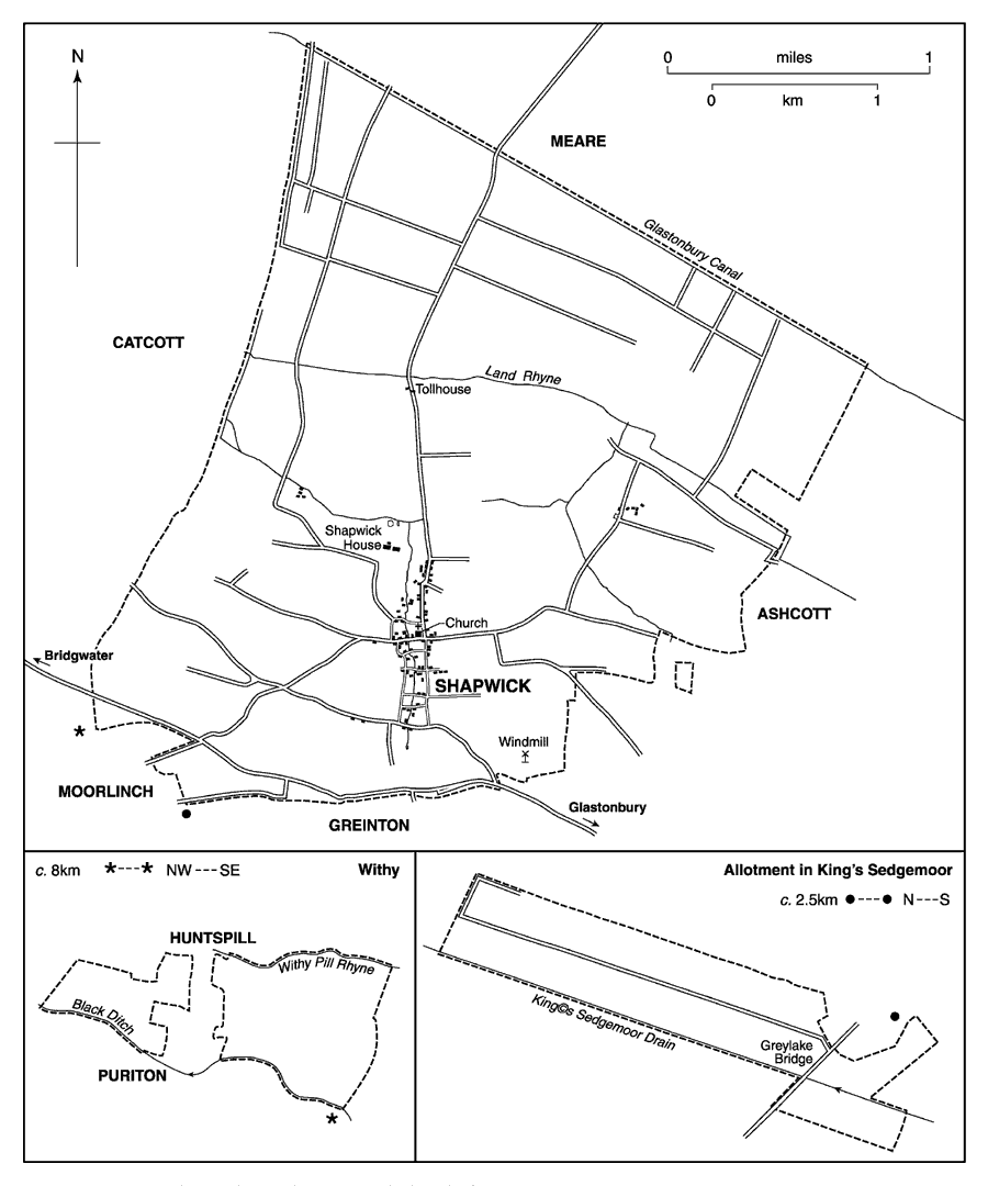
Shapwick parish 1839, with detached portions (inset)
Those east-west routes and smaller intermediate ones provided 'steps' for the irregular 'ladder' which formed the lanes within the village grid. Infilling and imparking in the 18th century caused the removal of more than half of the cross-lanes, and the deliberate straightening of the eastern side of the 'ladder' created a north-south route by 1839 (fn. 21) which was part of the turnpike route between Wedmore and Pedwell in Ashcott. (fn. 22)
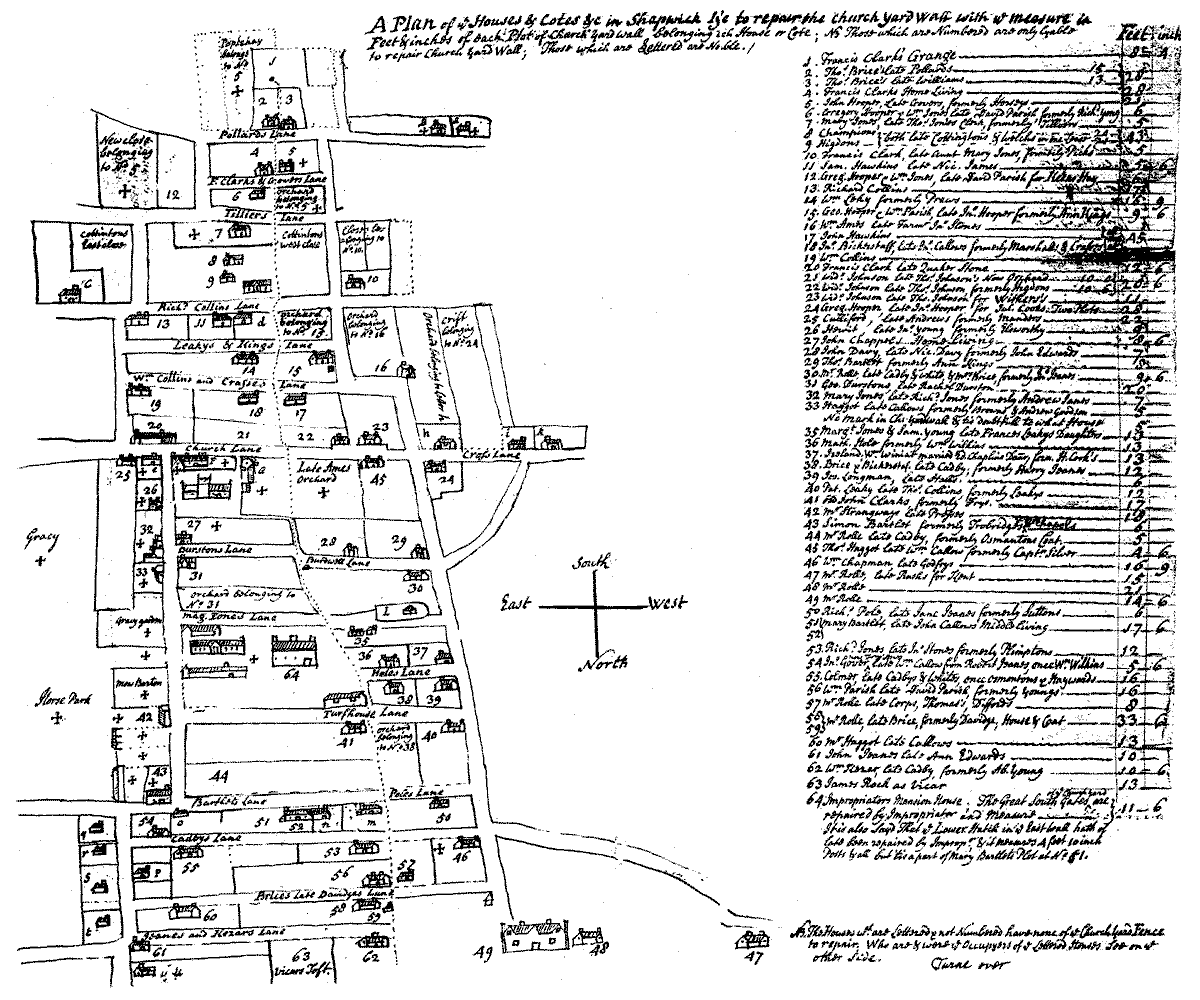
Map of Shapwick village 1764 (north at bottom) showing grid layout and area near Shapwick House before emparkment
In the Middle Ages a single route from the village to the seasonal pasture, meadow, and moor to the north crossed the mill stream by a bridge named in 1365-6 as Slapbrugge. (fn. 23) By 1822 three routes had been clearly established running northwards across Shapwick Heath to the northern boundary, and by that date a double avenue of trees had been planted, not necessarily to mark a road, curving gently across the moor from a road near Northbrook Farm almost to Catcott. (fn. 24) That avenue was not to be traced by 1889. (fn. 25) The Wedmore turnpike trust, under an Act of 1827, built the first through route across Shapwick Heath with a tollhouse by Moorgate Farm, north of the village. The road, which linked Rowberrow with Pedwell in Ashcott, was disturnpiked in 1874. (fn. 26) The bridge taking the road across South Drain was rebuilt in 1880. (fn. 27)
The Glastonbury canal adopted the South Drain as part of its course and opened in 1833. It was superseded by the Somerset Central railway, constructed on its bank, and was later acquired by the Somerset and Dorset Joint railway. Navigation closed in 1854. The railway opened in the same year and a station named Shapwick was built, two miles north of the village. The station and line were closed in 1966. (fn. 28) A network of narrow-gauge tracks served the Eclipse Peat Company's workings on Shapwick Heath, trucks being drawn by horses until c. 1930 and thereafter by engines. An engine stalled where the lines crossed in 1949 and caused the derailment of a passenger locomotive. (fn. 29)
POPULATION
In 1563 there were 48 households in the parish (fn. 30) and c. 1785 there were said to be c. 90 houses and c. 500 inhabitants. (fn. 31) In 1801 the population was 399, and between that date and 1881 hovered between 407 and 452. By 1891 it had fallen to 352 and continued to decline, reaching 275 in 1931. Twenty years later the total had increased to 325 and thereafter continued to rise, reaching 477 in 1991. (fn. 32)
SETTLEMENT AND BUILDINGS
There is evidence of use of the land from not later than 6,000 B.C. and of possible settlement in association with woodland perhaps after 3,000 B.C. Wooden trackways, including one known as the Sweet Track, constructed northwards across marshland from the Polden ridge and preserved in the peat, date between 3,838 B.C. and c. 500 B.C. Iron Age remains include an oak log boat, another timber trackway, and an enclosure. Roman occupation is found in at least twelve places well dispersed across the southern part of the parish and covering the period from the late 1st century B.C. to the late 4th century A.D. It was also found on the Nidons ridge on the edge of the moor, where in the remains of a villa was discovered the largest hoard of Roman coins found in Britain, totalling 9,213 and dating between 32 B.C. and 224 A.D. Three smaller hoards cover a longer period, between the 1st century B.C. and the 4th century A.D. (fn. 33)
It is suggested that by the 10th century there were four settlements within the parish, one of which included the parish church. (fn. 34) The earlier manor complex may also have been there. (fn. 35) In the tenth century a deliberate move relocated settlement in the centre of the parish on each side of a channelled stream. (fn. 36) The settlement survives in a still remarkably regular grid of lanes, now truncated in the north by the imparking around the manor house. (fn. 37)
Centralisation of settlement allowed the creation of open arable fields to east and west but left the church and manor complex isolated in the east field. The manor house was perhaps abandoned in favour of the buildings of an already established freehold estate on the north-west corner of the village grid in the later 13th century. (fn. 38) The old parish church was replaced by a new building within the village in 1330-2. (fn. 39) Thereafter until the late 18th century the only possible settlements outside the village grid were Fairsway, still apparently occupied in the late 12th century and named after the ancient east-west route through the parish, (fn. 40) and the mill site later Kent farm, to the north-west, presumably named after the tenants. (fn. 41) In the reorganisation of holdings on tenant farms in the later 18th century (fn. 42) a house and barn were built at Kent farm, and on part of the former east arable field Northbrook Farm and associated buildings were provided for the first ring-fenced farm in the parish. (fn. 43)
The distribution of older houses fairly evenly across the village implies a settlement of constant size but imparking around the manor house between 1770 and 1790 involved the destruction of some twenty dwellings, infilling, and the multiple occupation of many of the survivors. (fn. 44) Alterations made in the late 18th and the early 19th century by improving landlords have imposed a uniformity on the village houses and have disguised the age of many of them. The walls of houses built before the mid 18th century and of modest houses before 1900 are entirely of lias: only in two cases are cob cores likely to have been incorporated. Before the mid 18th century roofs were thatched and stone slates were reserved for the manor houses and their outbuildings and for eaves, for example at Kent farmhouse. Only Forsters, north-west of the church, is medieval. It is of fairly high status and was built in the late 15th century with an open hall, a solar jettied into it, and a service end. The roof, which has an archedbraced truss and windbraces, retains some medieval thatch. The house was given a chimney at an early date, a century or more before the hall and kitchen were floored.
At least sixteen houses survive from the 16th and the 17th centuries, most in fragmentary form. All except the two-roomed Old Forge seem to have had at least three ground-floor rooms in line, with a hearth-passage or central through-passage, and one or two storeys. Some single-storeyed houses, such as Home farmhouse, were made two-storeyed in the 17th century. Three conversions of earlier houses had architectural pretension. At Kent farmhouse a symmetrical facade, with two storeys of mullioned and transomed cross windows, was apparently applied in the late 17th century (a datestone reads 1688), and at Forsters the upper landing was embellished with ornamental plasterwork in 1712, which suggests the house still enjoyed a superior status. At the same period New farmhouse, then a gentry house, was extended into Shapwick's first double-pile house. All the new 18th-century houses, which included outlying farmhouses, had two storeys and end stacks. Roofs were clay-tiled and some brick was used, for example at Northbrook farmhouse, built c. 1778 with a classical brick-faced front. Late 18th- and early 19th-century improvements of existing houses included the raising of upper storeys, reroofing using clay tiles, refenestrating or refacing elevations, and providing new farm buildings. Manor, Beerway, and Canada farmsteads were newly built c. 1850 as plain classical three-bay villas accompanied by extensive outbuildings for mixed farming. More than twenty houses were built in the village in the 1970s (fn. 45) and further construction took place at the end of the 20th century often involving the conversion of farm buildings for dwellings.
SOCIAL LIFE
In 1311 17 ale sellers were in breach of the assize in Shapwick tithing. (fn. 46) In 1315 there were 21 illegal sellers, (fn. 47) in 1418 two. Two sellers were mentioned in 1535 and one in 1536. (fn. 48) There was a victualler in the parish in 1620, a tippler in 1622, and two victuallers in 1687. (fn. 49) A public house was opened near Shapwick station in 1856 under the name of the Griffin. By 1861 it was called the Railway hotel and by 1883 the Railway inn, but in the 1870s it was known as the Griffin's Head and the name Griffin alone had been resumed by 1889. It was closed in 1960 (fn. 50) and was subsequently demolished.
The Shapwick union or friendly society was registered in 1797. The Polden Hill friendly society was similarly registered in 1835 with altered rules in 1836, 1839, and 1840. (fn. 51)
A spring near Northbrook Farm, 1.4 km. north-east of Shapwick village, was known as Holy Well by 1754. (fn. 52) Elias Taylor, lord of the manor, built a small pump room and bath over the spring, which was saline and infused with sulphuretted hydrogen. The building, known as North Brook or Holywell, was erected between 1817 and 1822. It had become disused by 1885. (fn. 53)
The game of fives was played in the churchyard in the 1830s. (fn. 54) In 1850 a duck decoy was built by William Chancellor in what came to be called Decoy Pool wood on Shapwick Heath. It was still in occasional use in 1885 but had been abandoned by 1904. (fn. 55) In 1947 a youth club for boys met at Lawn House and a branch of the Women's Institute met at the village hall, itself formerly a bakehouse, turf house, and two cottages. (fn. 56)
MANOR AND OTHER ESTATES
The name Shapwick, meaning a sheep farm, is most recently interpreted as evidence that in the late Saxon period a multiple estate which might have been Roman in origin and which covered a large part of the Polden ridge, was divided into specialised constituent parts. That multiple estate, evidently once known as Pouelt, in 1086 with Shapwick perhaps as its administrative focus, stretched west as far as Woolavington. (fn. 57)
SHAPWICK MANOR
Glastonbury abbey had owned Shapwick long before the Conquest and offered in evidence a charter of 725 mentioning the church (fn. 58) and other charters of the 8th century involving an estate called Pouelt which is assumed to refer to an extensive estate on the Polden hills including Shapwick. (fn. 59) Glastonbury's ownership of Shapwick was recorded in 1086 when it was the focus of a unit of land assessed at 30 hides. (fn. 60) The abbey continued in possession until 1539.
The manor passed to the Crown on the dissolution of Glastonbury, and in 1553, with the manors of Moorlinch and Ashcott, and Whitley hundred, was granted in fee by the Crown to Sir William Petre. (fn. 61) All were sold back to the Crown in the following year, (fn. 62) and were leased to William Walton, his wife Elizabeth, and their son Richard. (fn. 63) William, or another of the same name, had been lessee of the demesnes under Glastonbury abbey since the time of Abbot John Selwood (d. 1492). (fn. 64) Walton and Jerome Halley were granted the estate in fee in 1554 and were immediately licensed to convey it to Sir Thomas Dyer and Thomas Walton, another son of William Walton. (fn. 65) Thomas Walton seems to have retained possession until his death in 1576 although his step-brother Richard Walton had occupied the capital messuage and probably the demesne farm by 1557 and was still there in 1569. (fn. 66) Thomas Walton was followed in succession by his son, also Thomas (d. 1622), who by 1618 had yielded possession to trustees to pay his debts. (fn. 67) In 1622 Thomas's son Francis and two of the trustees conveyed the manor to Abraham Burrell, and Burrell conveyed it in 1640 to Sir Samuel Rolle, Hugh Fortescue, and Henry Rolle. (fn. 68)
Samuel died in 1647 and was succeeded by his brother Henry, formerly chief justice of the King's Bench. (fn. 69) Henry, founder of the East Tytherley (Hants) branch of the family, died in 1656 (fn. 70) and was succeeded in turn by his son Francis (d. 1686) and his grandson Henry (d. c. 1692). (fn. 71) Henry was followed in succession by his sons Francis (d. 1709), John (d. 1727), and Samuel (d. 1729), (fn. 72) none of whom had issue. The estate passed to a distant cousin, John Rolle of Stevenstone (Devon), who in the same year settled it on his younger sons in succession. (fn. 73) John died in 1730 and was followed by his second son, also John (later John Walter), who died in 1779. (fn. 74) John's youngest brother, Denys, held courts from 1749 (fn. 75) and sold the manor to George Templer in 1786/7. (fn. 76) George Templer sold it in 1805 to Edmund Hill of Whitton, Twickenham (Mdx.), and in 1809-10 it passed to his nearest relative, Elias Taylor, clerk. (fn. 77)
Taylor died in 1827 leaving the manor to his nephew George Warry, although Sarah Taylor (d. 1854) retained the use of the manor house for life. (fn. 78) George died in 1883, his son George Deedes in 1904, and his grandsons George Taylor in 1904 and Bertram Arthur Warry in 1932. (fn. 79) In 1943 Mary Alice Shafto Warry, widow and sole heir of the last, sold the estate, with the exception of the manor house and adjoining parkland, to Samuel Vestey, 2nd Baron Vestey (d. 1954). (fn. 80) The estate remains in the hands of the trustees of the Vestey Settlement. (fn. 81) Mrs. Warry remained in occupation of the manor house until 1956 or later, although it had been a convalescent home during the Second World War. (fn. 82) It was subsequently converted to an hotel, known in 2000 as Shapwick House Hotel.
MANORIAL BUILDINGS
In 1260 one of the furlongs in the arable field east of the present village was described as next to the curia, (fn. 83) evidently the continuing focus of the manor but detached, like the parish church, from the main settlement. (fn. 84) In 1285 John of Taunton, abbot of Glastonbury 1274-91, acquired the substantial estate of his freehold tenant Walter of Shapwick. (fn. 85) It seems likely that the focus of the manor was then transferred to Walter's holding and that there, at the northern edge of the village, Abbot John of Taunton built a grange. (fn. 86) A chapel and oxhouse were mentioned in 1302-3 and in 1311-12 repairs were carried out on a hall, lead-roofed chapel, court house, kitchen, press room (domus pressorum), stable, dovecot, and oxhouse. (fn. 87) An eastern chamber was built in 1312-14 and roofed with stone tiles. (fn. 88) A chamber was used and a chapel presumably rebuilt by Abbot Walter Monington (abbot 1342-75). (fn. 89)
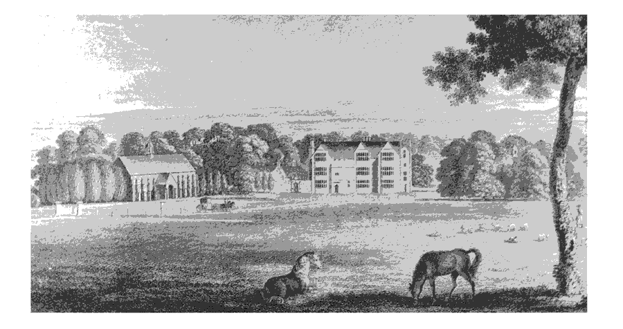
Shapwick House in c. 1790
The present Shapwick House Hotel, formerly the manor house and Shapwick House, stands within a moat which may date from the 12th century. (fn. 90) Externally the house appears to be of the earlier 17th and the 19th century, but it contains the substantial remains of an L-shaped building of c. 1489 comprising a first-floor hall and chamber above store rooms with a chamber wing to the east. The roof construction, with arched-braced trusses and windbraces, resembles other Glastonbury work and the position of the hall is characteristic of houses with ecclesiastical connections. To the west was a detached kitchen of c. 1430. (fn. 91) By 1515 the house and associated buildings comprised chambers, pantry, storerooms, kitchen, stable, garden, and barton within a moat, the whole measuring just under 2 a. (fn. 92) In the earlier 17th century the house was remodelled on an H plan and of three storeys. A gallery was inserted in the upper part of the medieval hall and the first-floor level changed to allow a new hall to be made on the ground floor with great chamber above. The west end was extended north and south to form a wing incorporating the kitchen, and the gable ends of the wings and the hall were embellished with canted bays. In the 18th century the interior of the house was remodelled, a dining room was added in brick north of the hall, and a service range to the north-west. Early in the 19th century the south front was made symmetrical by removing one bay and the medieval porch and replacing it with a single central porch in the Elizabethan style. In c. 1865 the north-west wing was extended south and linked to the existing service buildings which were remodelled. (fn. 93)
In 1325 the demesne site was described as a court and barton of 2 a. and elsewhere there were two dovecots. (fn. 94) Outside the moated site in 1515 were a barn, oxshed, and barton. (fn. 95) The barn survived until the later 18th century and, at least on one elevation, had a central porch flanked by four closely-spaced buttresses on each side. A cupola was placed in the centre of the ridge. (fn. 96) The hexagonal dovecot containing 1,092 holes was standing among trees in the grounds in the later 18th century, perhaps part of a landscaping scheme on the south side of the house which involved infilling ornamental ponds, the demolition of the barn, the removal of several houses on the northern edge of the village, and the creation of two ha-has. (fn. 97) A dovecot by the church, referred to in 1314-15, (fn. 98) was presumably on the earlier manor site. A great and a little garden were mentioned in the later 13th century, the larger ditched and planted with apple trees. (fn. 99) The latter may be the moated site to the north-east of the house.
The north side of the moat which surrounded the manor house was filled c. 1620, and thereafter a terraced garden with 'bastions' was created which seems to have included two canals and a banqueting house, with formal flower beds, sheltered from the west by an avenue and wilderness walks. (fn. 100) A park had been created by 1622 (fn. 101) and the banqueting house built by 1722, but the house seems to have been reduced in size between 1754 and 1787. (fn. 102)
RECTORY ESTATE
In 1230 Shapwick church was appropriated to Glastonbury abbey and the rectorial income was assigned to the abbey almoner. (fn. 103) The estate passed to the Crown at the dissolution of the abbey in 1539 and in 1543 John Berkeley bought a 50-year lease of the rectory, which included tenements, and tithes in Shapwick, Ashcott, Catcott, Chilton, Edington, Moorlinch, Sutton Mallet, and Stawell. (fn. 104) In 1573 Andrew Dyer was granted a 28year reversionary lease of the rectory and its tithes and a farm in Shapwick only, (fn. 105) but the complete rectory estate may have passed to Hugh Smythe by 1574, (fn. 106) and on his death in 1581 passed to his brother Matthew (d. 1583). (fn. 107) By 1595-6 Richard Walton had acquired Dyer's lease and seems to have been regarded as farmer. (fn. 108) He and his sons were ordered to hand over the estate except the mansion house to William Bull in 1618. (fn. 109)
In 1599 Sir John Spencer bought the freehold from the Crown, to be held of the honor of Hampton Court, (fn. 110) and he was succeeded at his death in 1610 by his daughter Elizabeth, wife of William, Lord Compton (cr. earl of Northampton 1618). (fn. 111) In 1619 the earl and his wife conveyed it to William Bull. (fn. 112) Bull died in 1622 and was followed by his son, also William (d. 1676), and by his grandson Henry (d. 1692). (fn. 113) Henry Bull, son of the last, died in 1695 and his surviving sister Elizabeth (d. c. 1714), wife of George Dodington, devised the rectory to her kinsman Henry Bull. Henry died in 1751 when his heir was his daughter Elizabeth (d. 1792), then wife of Thomas Strangways (d. 1766). (fn. 114) Elizabeth was followed in succession by her son Henry Strangways (d. 1805), her grandson Henry Bull Strangways (d. 1829), her great-grandson also Henry Strangways (d. 1884), and her great great grandson Henry Bull Templer Strangways (d. 1920). Sophia Georgina, younger and only surviving daughter of the last, died in 1932, and the rectory passed to her cousin Helen Sophia Vialls (d. 1949), daughter of Henry Vialls, who on succeeding adopted her mother's maiden name. (fn. 115) In 1944 Miss Vialls Strangways and her trustees sold the estate, including land in Moorlinch, Ashcott, and Sharpham to Lord Vestey. The vendor remained in occupation of the rectory house. (fn. 116) The house, which had been known as Down House by 1923, (fn. 117) is occupied as a school. (fn. 118)
About 1540 the rectory house comprised a hall, buttery, and kitchen with four chambers above, together with houses for brewing and malting. (fn. 119) In 1692 the house comprised a hall, two parlours, a study, kitchen, and cellars, all with first-floor chambers, and at least two chambers on a second floor above the kitchen chamber. (fn. 120) The present house, known as Shapwick Manor, is a plain, two-storeyed L-plan building of lias with four-light stone mullioned windows and a gabled two-storeyed porch on the main east front. An early 16th-century circular dovecot seems to have belonged to a house built between 1515 and 1540, remains of which may form the core of the present south wing. That wing became a parlour and chamber wing in the early to mid 17th century when an east range was built containing a one-bayed great parlour and a two-bayed great hall. Later in the 17th century the south wing was extended west and well-fitted stables were built east of the house and west of a large barn. In the 18th and 19th centuries additions were made in the inner angle of the L, chiefly to improve circulation. The north, service end of the hall range had disappeared by 1764 and was rebuilt in the 19th century, when the roof was recovered in Welsh slate and external and internal details were renewed as part of gentrification which included a screen wall and a new forecourt. (fn. 121)
By 1340 the almoner of Glastonbury had a barn which may have been part of the rectory or of his other holding in the parish. (fn. 122) There was a barn on the rectory estate by 1540 (fn. 123) and a dovecot by 1446. (fn. 124) The surviving circular dovecot has nesting holes for over 400 birds. (fn. 125) The present stable range dates from the later 17th century and the Jacobean garden screen appears to have been re-sited when the barn was demolished. (fn. 126)
East of the manor house site is a field known as Horsepark, part of which had been made a rabbit warren by 1726. (fn. 127)
WITHY
In 1189 Reynold of Walton held land at 'Witheges' in fee for which he paid 23s. at Michaelmas to the reeve of Shapwick. (fn. 128) The land formed a detached part of the parish of Shapwick between Huntspill and Puriton. (fn. 129) In the earlier 13th century Reynold of Shapwick was tenant of the same estate. (fn. 130) It is possible that the land may be identified with 'Inesuuyrth', linked with Huntspill in a grant made by King Offa directly or indirectly to Glastonbury. (fn. 131) It may also possibly be identified with the estate held in 1086 by Warmund or Garmund. (fn. 132)
In 1285 Walter of Shapwick, son of Reynold, granted what he held of the abbot in chief with his villeins and the service of a tenant in Withy to the abbey. (fn. 133) Possession of the estate was confirmed to the abbot by Philip de Columbers (VI), lord of Puriton, in 1331. (fn. 134) The abbey continued to hold the land (fn. 135) until the Dissolution. (fn. 136)
In 1544 the estate, described as a manor, was granted by the Crown to two royal servants who later in the year sold it to Sir Thomas Moyle (d. 1560). (fn. 137) In 1573 Thomas Kempe, one of Moyle's grandsons, was licensed to alienate the manor to Thomas and Francis Moore, the fine warranting against the heirs of Sir Thomas Moyle. (fn. 138) In the following year (Sir) Jasper Moore bought the manor with lands in Shapwick from Thomas and Francis, his father and older brother. (fn. 139) Sir Jasper died childless in 1610 (fn. 140) and the manor probably passed to his nephew Thomas Moore (d. 1623). (fn. 141) Thomas Moore (d. 1695), son of the last, of Spargrove in Batcombe, left it to his wife Elizabeth (d. 1696) and it eventually passed, after a Chancery dispute between Thomas's children, to his daughter Gertrude, wife of Anthony Methuen (d. 1717), of Bradford-on-Avon (Wilts.). (fn. 142) Anthony was followed in direct succession by his son Thomas (d. 1737), his grandson Paul (d. 1795), and his greatgrandson Paul Cobb Methuen (d. 1816). Paul Methuen, son of the last (cr. Baron Methuen 1838, d. 1849), was succeeded by his second son Frederick Henry Paul. (fn. 143)
OTHER ESTATES
In 1235 7 virgates were described as held by free tenants. The most substantial was (Sir) Reynold of Shapwick, whose 3 virgates, one in Withy, had been accumulated by his father Walter from the late 12th century from the Ralegh and Reigny families. (fn. 144) By 1260 (Sir) Walter, Reynold's son, had added a further virgate. (fn. 145) In 1285 the freehold was surrendered to the abbot of Glastonbury. (fn. 146)
About 1250 Thomas de Morton had a mesne lordship comprising ½ hide which he surrendered to the abbot in favour of his tenant Reynold le Gentil, who did fealty in 1261. (fn. 147) One half of that estate passed to Reynold of Shapwick, the other to John and Emme de Percy, who in 1285 surrendered their fee in return for a pension. (fn. 148) The Percy fee was assigned to the abbey almoner. (fn. 149)
Two other free tenants held in total just over 2½ virgates in 1235. William of Fairesway's was said to have been that granted to Henry of Fairesway by Abbot Michael of Amesbury (abbot 1235-52) which by 1260 had passed to Peter of Tuxwell. (fn. 150) One quarter of that estate was later held by John de Wydemuth. (fn. 151) William of Tuxwell made two grants of land to the abbey almoner. (fn. 152) By the 14th century, therefore, there was a considerable amount of land attached to the office of abbey almoner which was administered separately from both the rectory and the main abbey manor. (fn. 153) In 1539-40 it was said to measure 3 carucates. (fn. 154) The estate seems to have been regarded in the mid 14th century as the collecting point for the almoner's supplies. (fn. 155)
ECONOMIC HISTORY
The re-arrangement of the great multiple estate of Glastonbury abbey on the Polden ridge is assumed to have taken place in the late Saxon period and to have assigned to Shapwick a pastoral function. (fn. 156) By the later 11th century, however, subinfeudation suggests that such an arrangement had come to an end; the estate had virtually fragmented, and the abbey directly exploited only about a third of the unit that was Shapwick. (fn. 157) By the later 12th century there were significant freehold estates there and parts of the demesne were let, (fn. 158) but in the later 13th century most of the freeholds were acquired by the abbey, (fn. 159) leading to the creation of a unified estate whose demesne holding remained significant until the present.
AGRICULTURE
In 1086 the Glastonbury abbey manor of Shapwick was assessed at 30 hides but included land in Sutton Mallet, Edington, Chilton Polden, Catcott, and Woolavington which together amounted to 25 hides. In addition there was a ½-hide estate held of the abbot by Warmund or Garmund which may be identified as Withy. The whole, which may also have included Moorlinch, was assessed for 40 ploughteams but 20 more never paid tax. In Shapwick itself the demesne had 4 ploughteams with 6 serfs, and demesne stock comprised 2 riding horses, 23 beasts, 11 pigs, and 100 sheep. There were 12 teams for the rest of the land, which was worked by 5 coliberts, 15 villeins, and 16 bordars. Meadow measured 60 a., pasture 60 a., and underwood 57 a. Garmund's holding had 1 team in demesne and there were 4 bordars. (fn. 160)
In the later 12th century the Shapwick demesne was subject to change: when it was farmed before the 1170s there were still 4 ploughteams but it supported 400 ewes, 26 pigs, and 7 cows and calves; also in one year before 1171 there were 200 ewes, 32 oxen, and 14 cows. In 1171 there were only 15 oxen and 2 draught animals, and in 1189 27 oxen and 3 draught animals but no sheep. (fn. 161) By 1189 15 people held small pieces of demesne. (fn. 162) In 1201 there were only 3 ploughs on the demesne farm but a total of 350 a. of arable in two open fields, over half under wheat and the rest equally divided between oats and fallow, were cultivated by tenants. There were over 20 oxen, 1 draught animal, and 17 pigs, and a hundred ewes could have been supported. (fn. 163)
The expansion of cultivated land into the moors took place as in neighbouring estates and by 1257-8 an area of 35 a. described as 'in (apud) the moor' was sown with wheat. (fn. 164) By 1260 the demesne comprised 705 a. of arable, spread across the east and west fields, and 62½ a. of meadow valued at over £23. (fn. 165) By 1325 it had been reduced to 502 a. of arable and 111 a. of meadow. (fn. 166) A gardener, employed full-time on the demesne from 1301, produced apples and cider and there were two dovecots, the second built in 1313-14, producing over 550 squabs in 1274-5 and 360 in 1314-15. A hind and two or three oxherds were usually employed, by 1311 described instead as a carter and drovers. (fn. 167)
Between 1274 and 1335, according to surviving accounts, (fn. 168) wheat was grown on between 120 a. and 268 a. of the demesne farm, oats on between 39 a. and 93 a. Beans and barley were planted in very small quantities. In 1334-5 202 a. were fallow for one year, 158 a. for a second year, making with the sown area a total of 525 a. of arable. Livestock during the same period were principally oxen, totalling between 55 and 65 between 1300 and 1315. The 25 cows and 12 heifers claimed to have been removed in 1330 (fn. 169) find no confirmation in stock accounts, but may be explained as present on the manor for summer grazing. The same explanation may account for casual references to a sale of wool in 1300-1, to stock in single figures between 1298 and 1315, the construction of a sheepfold and employment of a shepherd for a flock of 160 in 1334- 5, and deaths from murrain in 1345. (fn. 170) A flock of at least 286 was there at Michaelmas 1330 of which at least some were still there a year later, and in 1352-3 31 ewes and 23 lambs were sent to Glastonbury. In 1366 38 sheep died of murrain and in the following year a total of 121 ewes was kept on the manor. In 1389-90 18 sheep were sent to Glastonbury before shearing, and in 1408 66 sheep died of murrain. (fn. 171) The abbot had a grant of free warren in 1330 and the warren was breached in 1356. (fn. 172)
In 1327 Withy measured just over 400 a., more than half meadow, and the demesne comprised 42 a. of arable, 154 a. of meadow, and 11 a. of reed bed. Seven free tenants held just under a quarter of the whole and there were nine villein holdings, predominantly arable and all subject to cash rents, four of which were also charged with haymaking services. (fn. 173) Earlier, in the period 1311-15, rents had totalled 60s. 9d., more than half payable at Michaelmas, but considerably more cash, amounting to over £16, was raised by leasing all the demesne to the villein tenants and by selling grazing or hay from the rest. (fn. 174) Thus in 1315 one villein tenant held a farm comprising 14 a. of arable and meadow 'of ancient tenure', 10 a. of demesne arable and 15 a. of demesne meadow, and 15 a. of meadow and 1 a. of reedbed of villein land for a total rent of 42s. 6d. and another paid £6 13s. 4d. for 34 a. of demesne. (fn. 175)
By 1330, however, most of the demesne was exploited directly by the abbey and rents of villein land had increased slightly from a population which had remained stable over the previous two decades. (fn. 176) A deficit of over £5 in that year was converted to a surplus three years later and the grassland provided summer grazing for abbey cattle including a small herd of milking cows. Wheat, barley, beans, and peas were grown but labour services were only partially revived, the abbey providing food and drink for autumn field work but paying cash for ploughing and for building ricks in the barton. A reeve, a dairymaid or dairyman, and a cattle boy were permanently employed. Exceptional costs in 1330-1 included scouring ditches throughout the estate and care of the abbey's herd of 73 cattle during a dispute with Sir Philip de Columbers. (fn. 177) There were losses of stock after flooding from 1346 which increased through lack of labour from 1348. The abbey's mixed cattle herd, moving between Withy and Sowy manor, was reduced from 65 to 48 in 1350, there was a great flood in 1351, and nearly half the demesne meadow hay crop was ruined in 1356. From the autumn of 1356, therefore, the demesne was leased for nine years to three men, two probably freeholders on the estate, the abbot retaining villein rents and other manorial dues. (fn. 178) In 1365 the manor was leased again for nine years, this time to a villein tenant; apparently the same land was leased for two years from 1373. (fn. 179)
The Glastonbury almoner's estates at Shapwick, comprising the appropriated rectory and a substantial freehold, were very small in comparison with the manor. In 1257-8 the income from both totalled £5 13s. In 1446-7 the rectory income of just over £45 included sales of grain accounting for more than half the total. The freeholding, which included land in Middlezoy, Ashcott, Pedwell, and Sutton Mallet, consisted principally of rents totalling over £19. (fn. 180)
In 1189 rents from the Shapwick manor estate, which included Withy, totalled over £13 and included payments for small amounts of demesne. Customary tenants comprised five virgaters, two of whom actually held 1½ virgate each; three half-virgaters, one of whom also held 5 a. and a mill; a holder of 15 a., and three who between them held four holdings of 5 a. Freeholders were led by Walter son of Reynold, who held 3 virgates, thirteen people who each held ½ virgate, 22 holders each of 5 a., and one man, Reynold, who held a moor. (fn. 181) By 1235 the number of customary virgaters had been reduced by one but half-virgaters had increased to fourteen, each paying smaller rents than their predecessors but owing more labour. There followed five tenants of 7½ a., twenty holdings of 5 a. and one of 2½ a. Only four free tenants were then recorded, suggesting that the earlier 5-a. holders had paid cash rents while they reclaimed parcels of moor but were subsequently absorbed among the customary tenants when reclamation had been completed. That reclamation had probably been at Withy. Customary rents by 1235 included small larder rents at Martinmas and hearth penny, paid in full only by married men. (fn. 182) By 1260 hearth penny had been renamed Peter's Pence and small vineyard rents and church scot had been added, but the general pattern of tenant holdings was little changed, although the only free holding recorded was that of the almoner of Glastonbury abbey, who by that date held 2 virgates together with 17½ a. of land in villeinage. (fn. 183)
By 1260 the labour services of virgaters were expressed in terms of cash equivalents. They included small amounts of ploughing, harrowing, and weeding, haymaking at Cowleaze, harvesting, collecting firewood at Baltonsborough, maintaining the park pale at Pilton, and carrying by packhorse. Half-virgaters performed a total of 96 day works, tenants of 5 a. 139 dayworks. The value of works at Shapwick and the abbey estate at Moorlinch was over £15 10s. as compared with a total of over £11 16s. from all rents. In 1257-8 works redeemed for cash amounted to 25s. (fn. 184) Rents remained roughly at the same level until after 1315 (fn. 185) but by 1331 they had risen significantly as the former freeholds were finally brought into manorial control, (fn. 186) part of a long-term process of physical and tenurial change which had included acquisition by the abbey of vicarage glebe in 1269, (fn. 187) and the introduction of villeinage life tenancies by 1302 which carried with them the incentive of freedom from serfdom. (fn. 188) The relocation of the parish church was the final step. (fn. 189)
In addition to rents, tenants of unfree status paid chevage. In 1300 50 names were recorded at the Shapwick halimote but only 19 actually paid a total of 8s. 5d. During the year two men were manumitted. Three who did not pay were described as paupers. In the same year an aid produced 58s. 6d. Between 1307 and 1315 between 82 and 65 names were recorded but in the first year only 46 actually paid and five were noted as dead. The highest total of chevage paid was 30s. 3d. in 1313-14. In 1345 there were 22 names of whom two had acquired their liberty, two were dead, and one was a pauper. The total raised was 5s. 10d. Numbers were slightly lower in 1346 and 1348, fell to 10 in 1350, and remained at either one or two between 1357 and 1404. (fn. 190) At Withy the numbers paying chevage were reduced from ten in the mid 1340s to four in the 1370s and to one in 1404. (fn. 191)
Few details of agriculture are available from the later 14th century until 1515 when the Shapwick demesne farm was divided. Nearly 400 a. in closes had been let before 1492 to William Walton and included a close described as sheep pasture; 320 a., all former demesne, was let apparently from 1515 at pleasure to 35 tenants; and a further 84 a. was let in small parcels as part of customary tenancies. Withy at the same time was similarly divided. The demesne pasture, called Withylease and described as fruitful, was let to Sir Thomas Speke with other abbey demesnes and the rest of the land, including some 44 a. of arable, was shared between 8 holdings, the largest of just under 40 a. The tenant of the largest holding also held fishing rights. (fn. 192) By 1539-40 the Shapwick demesne farm was let for £8 to William Walton the younger and comprised the manor house, 455 a. of arable and grass, and 36 a. of woodland. The almoner paid 22s. for 3 carucates, and fixed rents totalled £31 2s. 4d. The total gross income, including rent of the windmill, sales of strays and heriots, and court perquisites, principally entry fines, was £60 2s. 2d. At the same date the assessed rents of customary tenants on the Withy estate were unchanged from mid 14th-century levels and the demesne, probably then let, produced rather less than in the 1330s. (fn. 193) In 1538-9 the value of the rectory in Shapwick alone cannot be calculated, but the whole estate including tithes in Ashcott and in Moorlinch ancient parish was worth over £66. (fn. 194) About the same time tenants of the manor had common in Heath moor all the year round with responsibilities for driving the moor with tenants of Meare, Ashcott, and Walton. (fn. 195)
In the 17th century there was some small-scale consolidation of holdings by way of exchanges between the manor and the rectory, but the two estates remained largely unchanged, the rectory demesne measuring 201 a. in 1621. (fn. 196) In 1641 William Bull and Henry Rolle were each assessed at £10 in land as the owners of the two manorial estates, but Abraham Burrell was still holding part of the manor worth £8. A fourth substantial holder was William Champion. (fn. 197) In 1647 Bull's estate was assessed at £500, a sum reduced to £200 in 1651. (fn. 198) In 1692 the goods of Henry Bull were worth over £5,654. (fn. 199)
Henry Bull's farm stock then included 40 fat and 18 plough oxen, 35 fat Welsh steers, 32 steers and yearlings, 29 cows and heifers, 40 sheep, 12 pigs, 17 horses, and 3 donkeys. Crops comprised wheat, barley, peas, beans, oats, dredge, and vetches. (fn. 200) The two open arable fields were at the centre of farming activity, orders being regularly recorded for the removal of stock before 'Twelve Eve' and their re-entry after the crop had been cut and carried. (fn. 201) Holdings granted on the Rolle estate in the last two decades of the 17th century were, with one exception, under 50 a. and most under 20 a. (fn. 202)
By the later 1720s the two common fields, described as barley, corn, or wheat fields, were, as a result of continuous exchanges of strips, divided between several islands, each with its own rotation, and totalling c. 475 a. In 1733 the wheat field was also known as the Lower East Quarter field. (fn. 203) By 1754-5 arable was in four main units comprising West field (164 a.), Higher East field (103 a.), Lower East field (67 a.), and Northbrook (145 a.), each unit continuing to be subdivided into inclosed furlongs and each following its own rotation. In 1755 there were 361 a. of wheat, 197 a. of Lent corn, and the rest planted with vetches, peas, beans, barley, and oats. (fn. 204) By 1787 the common arable had been reduced to 340 a. (fn. 205) References to stock are rare but include a general ban on geese in Turf moor and of sheep on Heath moor except between St. Andrew's tide and Candlemas (30 Nov.-2 Feb.). (fn. 206)
Short-term leases had been introduced by 1721 when part of the rectory estate was let for four years to a butcher and comprised a farm of arable, meadow, and pasture with buildings including two houses, one described as old, a crib house, a new stable, penning, rick bartons, and a chamber over the coach house. The lease was renewed to the same tenant in 1726 and 1736, the second time for seven years and with a slightly increased acreage. By 1809 the farm had increased in size to 260 a. (fn. 207) By 1790 tenant holdings on the manor estate had been reorganised under the names of Little, New, Kent, Home, and Northbrook farms. Kent farm had been Kent Tenement for many years and Northbrook was first rated in 1778 and was the first purpose-built ring-fenced farm in the parish. New farm was formed from parcels of demesne in the three common fields then called East, West, and Windmill fields. All were let on leases for 7 or 14 years. (fn. 208) Withy had before the end of the 17th century been divided between one principal holding of 140 a. occupied by the owner and one small holding. (fn. 209) The same pattern continued through the 18th century, though by 1792 the larger farm was let. (fn. 210)
Farming in the 1780s in Shapwick was 'but indifferently practised' and quick hedges were 'badly managed'. Only some 320 a. were under arable, principally for wheat and beans; some turnips were grown but not hoed and there was some clover. (fn. 211) The parish was thus predominantly under grass, including artificial grass, 1,105 a. of Turf moor having been inclosed in 1784 under an Act of 1777. (fn. 212) Earlier improvements had included the construction of Moor rhyne along the northern boundary before 1730 and of Land rhyne, thus effectively inclosing 201 a. called Shapwick Moor Ground at the northern edge of the parish. (fn. 213)
Further reorganisation of tenant farms had produced eight farms on the manor estate by 1830. The whole totalled 2,830 a. and included 610 a. of turbary, 100 a. of meadow on King's Sedgemoor, and c. 100 a. of woodland. Home farm (248 a.) was in hand; Kent and Northbrook farms measured 340 a. and 320 a. respectively, New farm 270 a., Manor and Hill farms each 230 a., Old and Church farms each 90 a. (fn. 214) Some amalgamations were effected during the next decade because of farming failures, at least one tenant having to pay rent in teazle plants, wheat, and equipment rather than in cash, and another was removed as he had no stock and no implements on which to distrain. (fn. 215) By 1839 Home farm measured 624 a., Manor and New farms together 544 a., Northbrook 360 a., Kent 330 a. The largest farm on the rectory estate in the parish, later Church farm, was 245 a. Arable land then accounted for 576 a. and grass 2,885 a. (fn. 216) By 1851 the owners of both estates had made great improvements, and 'fine' turnips and 'magnificent' rape growing on the moor dwarfed the sheep feeding there. (fn. 217) In the 1860s 'fair' wheat and potatoes were grown on the rectory estate and cheese was the chief product. (fn. 218) There were then ten farms of over 100 a. of which one was 380 a. and there were the same number at the end of the decade of which Kent farm was the largest with 402 a. (fn. 219) Two farms were unoccupied early in 1891. (fn. 220)
The area of arable remained stable at the beginning of the 20th century (fn. 221) and wheat, hay, beans, and oats were said to be the chief crops. (fn. 222) Caerphilly cheese was produced on Kent farm in the 1930s. (fn. 223) By 1943, when the Manor estate of 2,789 a. was sold to Lord Vestey, there were 15 farms, of which seven measured between 190 a. and 292 a. and the rest under 100 a. including Brickyard and Canada farms, both in the moors. The five farms of the rectory estate sold to Lord Vestey in 1944, totalling 371 a., included two with land in Ashcott. (fn. 224) By 1989 there were 8 active farms but ten years later the total had been reduced by amalgamation to 6, of which two were sold to the tenants. (fn. 225)
QUARRIES
Stone was quarried in the parish by the mid 15th century and was used for the tomb of Abbot Nicholas Frome (d. 1455). (fn. 226) A quarry for blue lias was worked in two halves for most of the 18th century. (fn. 227) Little lime was burnt or used in the 1780s. (fn. 228)
WOODLAND
Woodland seems to have been post-Roman in date but in the early Middle Ages may have been more extensive than the 57 a. of underwood recorded in 1086. (fn. 229) In 1325 the largest piece of woodland was Loxley, measuring 50 a. and grazed in severalty between 2 February and 1 August each year. There was also an 8-a. spinney at Caterwood, more at Broadwood on one of the parish boundaries, and a small area of woodland at Rodmoor. (fn. 230) Loxley was a source for thorns for Greinton manor in 1345-6. (fn. 231) By 1515 it measured 36 a. and comprised oak standards, underwood, and pasture. (fn. 232) In 1531-2 2,600 oaks were felled and sent to Glastonbury and 200 faggots were made. (fn. 233) Arbitration in 1538-9 established that tenants had access to Loxley between 31 August and 2 February but could claim spars and stretchers to repair their houses from the lord at any time. (fn. 234) Loxley wood and green measured 52 a. of pasture in 1643 (fn. 235) and tenants of the rectory regularly, but unsuccessfully, stated their claim to common pasture there in the 17th century (fn. 236) and at least three rectory tenants were excluded. (fn. 237) About 1730 John Rolle enclosed half the wood but the lay rector continued to claim that his tenants could take spars, stretchers, and 'garden wreath'. (fn. 238) Some rights were relinquished by his tenants to the owner of the rectory in 1766. (fn. 239) In the 1780s the wood produced large oak timbers. (fn. 240) In 1839 there were 127 a. of woodland in the parish. (fn. 241) In 1905 there were 150 a. of woodland, (fn. 242) divided between Loxley and plantations. By 2000 Loxley had been sold by the Vestey estate to the Woodland Trust. (fn. 243)
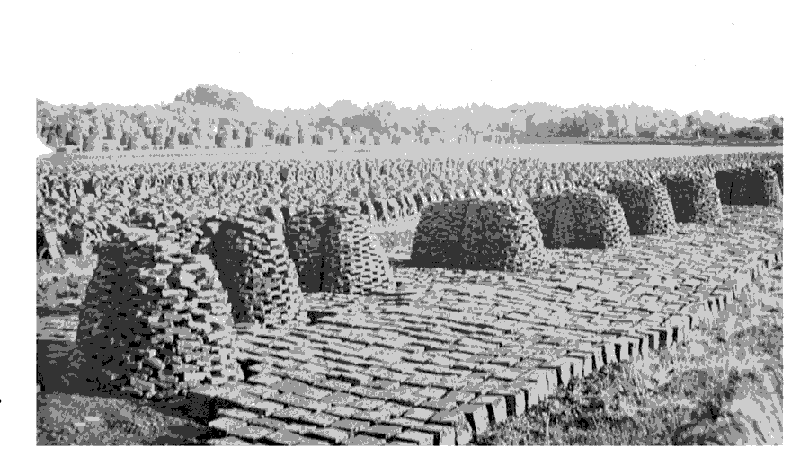
Shapwick turbary
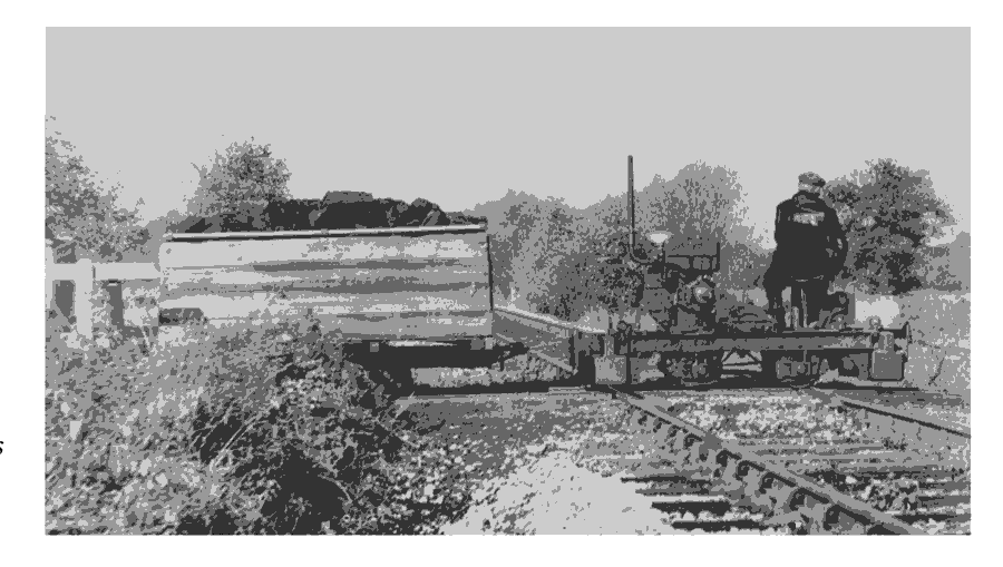
The Eclipse Peat Company's light railway carrying peat from diggings in Shapwick to works at Meare Heath
TURBARY
In 1313 and 1374 there was illegal turf digging. (fn. 244) By 1515 all tenants were allowed to dig turves for their own use in Heath moor, but were not permitted to sell them. (fn. 245) The abbey almoner as rector had no income from the turbary in 1531-2 and 1538-9 because there was no digging. (fn. 246) In the later 17th century both turves and tufts of matted grass known as hassocks were being dug, the latter considered as good as turves for brewing. Digging was strictly limited by the position of markers established in the rectory court, where regulations about fencing the pits and preserving rights of way were rehearsed. (fn. 247) In 1668 turf cutting delayed the harvest. (fn. 248)
In the mid 18th century repeated orders from the rectory court indicate illegal digging, the lord of the manor, the vicar, and 20 others being accused in 1759 of extracting turf above what was called the town mark. (fn. 249) Loads of turf were dug for the poor in 1763. (fn. 250) Pressure was expected on the 610 a. of turbary on Shapwick manor in 1839 because of the decrease in similar business in Ashcott. (fn. 251) By the late 1860s machinery had been introduced on a small scale, but men, women, and children were still employed in large numbers in the summer, cutting, stacking in heaps called hiles for drying, and afterwards in heaps called ruckles. (fn. 252) 'Great quantities' of peat were being extracted in 1872 when three turf merchants were in business there. (fn. 253) By 1889 the Eclipse Peat Manufacturing Co., based in Ashcott, was producing moss horse litter and fire lighters from the turbary, working alongside individual farmers and merchants. (fn. 254) In 1891 there were two turf or peat merchants living in the parish. (fn. 255) In 1945 the Eclipse company, which had leased just over 55 a. from the Vestey estate, bought 352 a. in East and West moors (fn. 256) and in 1950 received unconditional planning permission to extract from 482 a. of Shapwick Heath, the demand for the product by that time almost entirely horticultural. (fn. 257)
MILLS
There was a mill, probably a watermill, in the parish in 1189 (fn. 258) and it continued in use until the 16th century. (fn. 259) No further references to a water mill have been found, though a mill pond near Kent Farm was mentioned in 1713, and the mill stream was recorded in 1740 in the same area (fn. 260) and is still so named. There was a provender mill in the farm buildings in the 1930s. (fn. 261)
A windmill had recently been built by 1325 (fn. 262) and was mentioned in 1446 and in the 16th and the 17th century. (fn. 263) The mill, in the occupation of Richard Jones in 1716, was reported out of repair in 1742. (fn. 264) Richard Jones still occupied a windmill there in 1761 as well as one in Moorlinch. (fn. 265) It was replaced c. 1762 by a new mill on a site to the north-east (fn. 266) which was occupied by the Jones family until destroyed in a gale in 1836 in which William Jones was fatally injured. (fn. 267) A third mill, on a site futher to the north-east and still let to the Joneses, was evidently burnt down twenty years later. (fn. 268)
A steam flour mill had been installed by 1839 on a farm south of the village, later known as Hill farm, and was in operation until soon after 1910. (fn. 269) A steam saw had been added by 1905 (fn. 270) and was still in operation in 1909. (fn. 271)
TRADES AND CRAFTS
Most of the known tradesman in the village were directly or indirectly associated with farming. A butcher from the parish was in trouble in 1387 for selling in Bridgwater. (fn. 272) In 1640-1 oak bark was sent from High Ham, presumably to a tanner. (fn. 273) A chandler occurs in 1743. (fn. 274) By 1841 there was a wide range of craftsmen including 7 carpenters, 5 tailors, 5 masons, and a gilder. (fn. 275) Twenty years later there were 11 carpenters and 7 masons, most if not all probably employed on the manor and rectory estates, and six gardeners to maintain the grounds of the manor and rectory houses. By that date there were 3 shops in the village, 5 dressmakers, a milliner, and 3 laundresses. (fn. 276) A grocer and draper and a baker were in business by 1871 and by 1891 3 butchers. (fn. 277) Tradesmen closely connected with agriculture included a cider merchant by 1861, a corn dealer by 1861 until 1889 or later and another by 1910 until 1931 or later, and a hay, corn, oil cake, and coal merchant, operating from the railway station, by 1906. (fn. 278) In 1939 a blacksmith, a butcher, a baker, and a grocer were all in business, together with a firm of builders, undertakers, carpenters, and wheelwrights. (fn. 279) In 1947 the village was served by a general shop, a butcher's shop, and a bakery, and tradesmen comprised a chimney sweep, a blacksmith, and a man specializing in household repairs. Thirty years later there was one shop and post office, (fn. 280) and that had closed by 1998. (fn. 281)
A brickyard was opened in the north-west of the parish; Brickyard farm was so named by 1871. (fn. 282)
LOCAL GOVERNMENT
Shapwick tithing comprised the whole ancient parish including the detached area at Withy. (fn. 283) In 1622 the tithingmen at Whitley hundred court reported that the archery butts were not maintained. (fn. 284) A presentment to the hundred court in 1716 concerned the regulation of grazing in the open fields. (fn. 285)
The manor court, described as a halimote court, was in operation by 1257-8. (fn. 286) By 1307 it had jurisdiction over halimote courts of Shapwick, Withy, and of that part of Moorlinch belonging to Glastonbury abbey. The courts met together on or near Michaelmas and Hockday, usually at Shapwick, (fn. 287) and were presided over by the abbey's cellarer and steward. (fn. 288) Each halimote had a narrator or spokesman and employed a hayward. Additional sessions, usually described simply as courts, were sometimes held in the spring or summer; one in 1302-3 was called 'the court held for Polden'. (fn. 289) Records of the Shapwick and Withy courts survive for over ninety sessions between 1265 and 1408. (fn. 290)
There was apparently no separate court before the Dissolution for the rectory estate held by Glastonbury abbey's almoner, but in 1531-2 the almoner contributed towards scouring the 'common river', gave 24s. to six paupers, and a feast 'by ancient custom' to the parish 'ministers'. (fn. 291) After the Dissolution the rectory estate was described as a manor, sometimes described as Shapwick with Moorlinch manor. Court papers survive for many years between 1609 and 1778 and sessions were described variously as court baron or manor court. The court normally met at the rectory house but in 1722-3 and 1725 was held at the house of a tenant, Elizabeth Collins. Tenancy transfers involving land in Middlezoy and Moorlinch as well as Shapwick formed the normal business. Meetings were annual from 1729, usually in the autumn until 1740 and thereafter in the spring. Three times in the 1720s sessions were held in the house of a tenant. No court was held in 1777 'for want of copyholders'. Presentments concerned repairs, statements of rights in Loxley wood, and breach of farming regulations. A hayward was appointed annually and a variable number of viewers was concerned with fences, watercourses, droves, and buildings. (fn. 292)
Parish government in the 18th century was limited by the active manorial courts largely to poor-law administration and the fabric of the church. Churchwardens were chosen in rotation in respect of their holdings and 'public' vestries comprised the vicar and up to seven other members, with an occasional general meeting of parishioners. In the mid 18th century payments to paupers were made monthly and took the form of cash, canvas, cloth, fuel, rent, or food. (fn. 293) A poorhouse was mentioned in 1832. (fn. 294) The parish became part of Bridgwater poor-law union in 1836 and of Bridgwater rural district in 1894. It formed part of Sedgemoor district from 1974. (fn. 295)
CHURCH
ORIGINS
The church, noted in the spurious charter of King Edgar of 971, (fn. 296) is first certainly mentioned in 1168, when it was considered one of the seven churches attached to Glastonbury abbey, a group later forming the core of the archdeaconry of Glastonbury. (fn. 297) A pension of 20s. was paid to the sacristy of Glastonbury by 1191 until 1428 or later. (fn. 298) The living was appropriated in 1230 for the benefit of the abbey almonry, (fn. 299) but the value of the estate, measuring some 75 a. of arable in 1446-7, (fn. 300) has been exaggerated, leading to unfounded claims that the church in origin was 'collegiate' and a likely minster. (fn. 301) Shapwick was, however, the mother church of Ashcott c. 1244. (fn. 302) Shapwick and Ashcott continued to be a single benefice until 1974 when they were linked with Burtle. (fn. 303)
PATRONAGE
Until the Dissolution the abbot and convent of Glastonbury appointed to the vicarage. (fn. 304) Thomas Walton, lord of the manor, was holding the advowson in 1559. (fn. 305) His son, also Thomas, in 1594 granted the next presentation to the incumbent, John Powell. Powell's widow appointed a vicar in 1608. The next presentation, in 1638, was made by Abraham Burrell, (fn. 306) then lord of the manor, (fn. 307) and the advowson descended with the lordship but it was retained by George Templer on the sale of the manor. (fn. 308) George Henry Templer, son of the last, died in 1849 and the patronage passed to his wife's nephew, Sir Graham Graham-Montgomery, Bt. (d. 1901). (fn. 309) He was followed successively by two sons, James Gordon Henry (d. 1902) and Basil Templer Graham-Montgomery. (fn. 310) The last presented in 1906 (fn. 311) but by 1910 the right of presentation had passed to Henry Bull Templer Strangways, lord of the rectory manor and grandson of G. H. Templer. (fn. 312) From that time the advowson descended with the rectory estate and was purchased in 1944 by Lord Vestey. (fn. 313) From 1974, when the vicar accepted in addition the cure of Burtle, the bishop of Bath and Wells became patron every second turn in three. (fn. 314)
ENDOWMENT
In 1291 the vicarage was valued at £4 13s. 4d. (fn. 315) It was considered too poor to pay tax in the later 15th century (fn. 316) and in 1535 its net value was £9 13s. 4d. (fn. 317) About 1540, when the vicar no longer employed a chaplain at Ashcott, it was worth £13 6s. 8d. (fn. 318) The living was augmented in 1655 (fn. 319) and c. 1670 the reputed value was £60. (fn. 320) The net value was said to be £46 17s. 4d. in 1707 (fn. 321) and in the early 1830s £215. (fn. 322) In 1884 Mrs. Strangways added the interest on £3,000 to augment the benefice, which in 1906 was valued at £255. (fn. 323) In 1885 the augmentation took the form of land later held by the Montgomery and Strangway Trust, which was subsequently incorporated with the benefice glebe. (fn. 324)
From 1230 the vicar was given the service of five men, all altarage, some small tithes, land at Withy, all tithes of the church estate demesnes, and tithe of mills. Details were modified in 1269 so that the vicar received tithe corn from nearly all crofts and a house at Ashcott in return for transfer to Glastonbury abbey of some land, the tithes on the old demesne of the church, and his principal house in Shapwick. (fn. 325)
In 1535 tithes were valued at £5 9s. 8d. (fn. 326) and in 1705 were described as privy tithes and the corn tithes of Pedwell in Ashcott. (fn. 327) Two years later they were valued at £22 10s. (fn. 328) Oblations in 1535 amounted to £7 17s. (fn. 329) In 1839 tithes were commuted for a rent charge of £110. (fn. 330)
Glebe lands were worth 33s. 4d. in 1535 and £25 10s. in 1707. (fn. 331) In 1638 there were nearly 32 a. of glebe, of which 7a. were in Withy, assigned to the vicar in 1230. (fn. 332) There were 48 a. of glebe in 1839 (fn. 333) and 46 a. in 1906. About 33 a. were sold in 1920 and most of the rest in 1991. (fn. 334)
In 1230 the vicar was given the house in Shapwick where the chaplain used to live. (fn. 335) In 1269 it was returned to Glastonbury abbey in exchange for a house beside the chapel at Ashcott. (fn. 336) A house in Shapwick was evidently occupied by successive resident vicars after the Dissolution and stood in a lane northwest of the church. (fn. 337) By 1835 it had been replaced by a house south-east of the church. (fn. 338) That was rebuilt in 1928 after damage by fire two years earlier and was replaced by a new house, designed by R. Chambers, on the north side of Vicarage Lane in 1991. (fn. 339)
CHURCH LIFE
The abandonment of settlement beside Shapwick's first parish church, perhaps in the late Saxon period, and its dedication by the earlier 13th century to St. Andrew (fn. 340) indicate an early foundation. The new church within the village was consecrated in October 1331 after a request made by the abbot of Glastonbury in the previous month, (fn. 341) and was evidently dedicated to St. Edith (feast 16 Sept.). That date, normally a weekday, proved by 1464 to be inconvenient when farm work was pressing, and the patronal feast was therefore changed, only by a few days, to the Sunday following the Exaltation of the Holy Cross (16 Sept.), when parishioners were not at work. (fn. 342) By 1541 it was named after the Blessed Virgin Mary, to whom an altar had been dedicated c. 1245. (fn. 343)
From the 12th century the parish was associated with the Glastonbury cult of St. Indract, who with St. Dominica and others were said to have been martyred there on 8 May 708. (fn. 344)
The name Holy brook for a stream running through the west arable field from the earlier 14th century (fn. 345) and the holy well established north-east of the village by 1754 (fn. 346) may be echoes of early religious sites.
Walter of Ashcott was a deacon when admitted to the benefice in 1351 and successive incumbents from 1442 were usually described as chaplain rather than priest. (fn. 347) Clergy were normally resident in the 16th and 17th centuries, (fn. 348) but George Collier was already rector of Nunney when appointed vicar in 1638. Only Shapwick was restored to him in 1660. He himself was removed in 1650 and his place was taken in 1655 by Edward Lovell, described as 'a godly and well affected able person'. (fn. 349) Charles and Thomas Hobbs, successively vicars between 1791 and 1810, were also rectors of Cossington. (fn. 350) George Henry Templar, vicar from 1810 and owner of the rectory manor, was also rector of Thornford (Dors.) at the same time and prebendary of Wells from 1811. He lost a long lawsuit at Thornford in 1827 and from 1841 until 1846 his living at Shapwick was sequestrated because he was an insolvent debtor. (fn. 351) A resident curate was being employed by 1827. (fn. 352)
Neither altar nor chalice had been blessed when restored in 1554, but in 1557 Evensong was held on Saturdays as well as Mass on Sundays. (fn. 353) The communion table was ordered to be railed in 1634 but the pulpit cushion and fringed cloth of green kersey were said to be 'very comely'. (fn. 354) The table was replaced in 1725. (fn. 355) There were c. 20 communicants c. 1780, (fn. 356) and a group of singers in 1796. (fn. 357) In the first half of the 19th century there was one service with sermon each Sunday and communion at least three times a year. (fn. 358) By 1873 two services were held each Sunday, both with sermon, and communion was celebrated monthly. (fn. 359)
A church house, mentioned in 1594, was reported in decay in 1609. (fn. 360) In 1825 the churchwardens owned 3 a. of land which they are known to have held in the 18th century and claimed 'from time immemorial'. (fn. 361) The Church Lands charity continued in 1995. (fn. 362)
CHURCH FABRIC
The earliest church on the abandoned site to the east of the present village was of a single cell, to which a buttressed crossing tower and a chancel were added further east. It was replaced in 1331 by the present church, evidently a deliberate copy of the old, and by then obsolete, layout. (fn. 363) During building work the tower was temporarily roofed with reed from Withy. (fn. 364) That central, two-stage tower is the same width as the two-bay chancel; slightly wider nave, also of two bays, is aisleless and has an inexplicably long expanse of windowless wall at the west end. Two piscinae and the font survive from the original building. In the 15th or the early 16th century new windows were inserted in the nave, which was given a cradle roof and a Doulting stone pulpit. In the 1780s the roof of the nave was ribbed and had carved figures, painted blue, at the intersections. Both altar and desk were of old oak and the pulpit was of stone with Gothic panels and a sounding board. A west gallery was supported on four round pillars and the walls were covered in 'oval paintings' with prayers and texts. (fn. 365) The tower and nave have been heavily restored and the whole church refitted to designs of 1860 by (Sir) George Gilbert Scott; the nave north windows were replaced or renewed in early-14th-century style. The chancel was almost completely rebuilt, also in Decorated style and most probably to Scott's designs, and a north vestry added. Scott certainly designed the benches in the chancel. (fn. 366) The 17th-century altar rails and communion table and 19th-century Commandment tables have been moved from their original positions. There are two large monuments of the 17th century to members of the Bull family.
There are six bells of which the oldest, the 3rd, is from the medieval foundry at Bristol by T. Jeffries. The 4th is by Robert Austen, and three were made in the early 18th century. (fn. 367) The plate includes a cup and bowl of 1746 and a cover, flagon, and two dishes inscribed 1747, all by Gurney and Co. (fn. 368) The registers date from 1590 but were irregularly kept in the 17th century and are incomplete. (fn. 369)
NON-ESTABLISHED CHURCHES
Between the 1590s and 1641 members of four families were reported as popish recusants. (fn. 370) The house of William Ames was licensed for use by Quakers in 1689. In 1690 the Polden Hill Meeting moved to the village from Sutton Mallet and for a time was held alternately there and at Greinton. (fn. 371)
EDUCATION
In 1372-3 an unlicensed school was being conducted by an unfree tenant of the manor. (fn. 372) In 1680 a man was licensed to teach boys in the vernacular. (fn. 373) In 1805 a school was being held in a cottage. (fn. 374) In 1819 a Sunday school taught 20 boys and 30 girls. (fn. 375) It was still in operation in 1847, with 9 boys and 26 girls. (fn. 376) By 1833 there were three day schools for a total of 22 boys and 29 girls. One of those had been founded in 1819 and was partly supported by Mrs. Templer. The Sunday school then had 38 pupils. (fn. 377) A former school house was standing in 1839. (fn. 378) A parochial school was built in 1840. (fn. 379) In 1903 there were 90 pupils on the books and the school building, owned by the lord of the rectory manor, was also used by the parish council and for missions and concerts. (fn. 380) Attendance at the school, which was voluntary aided after 1944, fell to an average of 26 in 1965 and after an increase in the 1970s fell again. It was closed in 1984 and thereafter children went either to Ashcott or Catcott. (fn. 381)
In 1847 there was a commercial school for 9 boys. (fn. 382) A ladies' school had been opened by 1861; a boarding and day school for ladies in 1866, under different ownership, may have been the same establishment. (fn. 383)
Edington and Shapwick school occupies Shapwick Manor as well as several buildings in Burtle in Edington. It was founded in 1974 to provide specialist education for children with dyslexia and is an independent school. The Shapwick site takes children from the age of 13. (fn. 384)
CHARITIES FOR THE POOR
By will dated 1604 Henry Smith devised land in Stoughton (Leics.) to Shapwick among other parishes to provide work, apprenticeships, clothing, and food for the poor. The clothing was to consist of cloth of one colour with the badge of the donor, the food to be bread, meat, or fish distributed each Sunday. In 1782 Shapwick's share of the income was over £11 and in 1783 nearly £13, but in 1786 only £5 5s. (fn. 385) From 1811 onwards the trustees distributed 'gift money', producing in that year £10 6s., and money under deed polls yielding £6 2s. 3d., and later described as investments on local turnpikes. The origin of the investments was variously described as arrears of the Smith charity or as sums left by William Colton and others at unknown dates. (fn. 386) In 1825 distribution to the second poor, those not regularly in receipt of poor relief, was said to have fallen in the previous three years from over £11 to £10 10s. (fn. 387) In 1834 the total income was £18 19s. By the 1880s the income derived from Stuckey's Bank and the Bridgwater Mutual Benefit Building Society and amounted to over £19. (fn. 388) By a Scheme of 1972 the charity was amalgamated with that of James Alexander (d. 1823), a native of the parish, who by will of 1818 had given £150, the interest to be distributed at Christmas to poor not receiving relief. (fn. 389) The Smith charity, worth some £650, continues to be distributed to those in need. The Alexander charity is an educational fund worth c. £30 used for the support of a young person. (fn. 390)