A History of the County of Warwick: Volume 7, the City of Birmingham. Originally published by Victoria County History, London, 1964.
This free content was digitised by double rekeying. All rights reserved.
'The Growth of the City', in A History of the County of Warwick: Volume 7, the City of Birmingham, (London, 1964) pp. 4-25. British History Online https://www.british-history.ac.uk/vch/warks/vol7/pp4-25 [accessed 25 April 2024]
In this section
THE GROWTH OF CITY
The city of Birmingham (fn. 1) now covers an area of 51,147 acres and houses 1,105,651 people (fn. 2) on land which at the time of the Domesday survey was parcelled out amongst a dozen manors whose identities are preserved in the names of a dozen populous suburbs. (fn. 3) The circumstances of this exceptional growth have been the subject of speculation. William Hutton attributed much to freedom from damp on the sandstone ridge, (fn. 4) to a plentiful supply of good water (fn. 5) and, by implication, to the bracing climate, for he says of the inhabitants 'they possessed a vivacity I had never beheld.' (fn. 6) But his statement that 'a town without a charter is a town without a shackle' shows that he did not ascribe the town's progress solely to physical conditions. Nor did the writer of the following: 'This town being no corporation . . . is free for any person to come and settle in it, which contributes not a little to the increase of its trade, buildings and inhabitants, the rapidity of which is truly amazing.' (fn. 7) Samuel Timmins and J. T. Bunce emphasized the absence of trade guilds and companies and the freedom from discrimination for nonconformists. (fn. 8) Other writers have stressed the importance of Birmingham's geographical position, (fn. 9) and have shown that the town lay across important lines of communication. (fn. 10) Others again have referred to the supply of sand and charcoal for industrial purposes. (fn. 11) The combined advantages of unincorporated status, water-power, an industrial tradition and proximity to a coalfield were, however, enjoyed by other Midland towns and at least one commentator has been forced to add the factor of a large supply of good drinking water. (fn. 12)
Since Birmingham was neither a port nor a corporate borough, and since it has lost the court rolls and bailiffs' accounts that would have thrown some light upon its early organization and activities, it is difficult to construct a comprehensive explanation for its development. Furthermore, the interplay of physical and human factors has grown more complex as the town has expanded. But when every environmental advantage has been listed it is still necessary to give much weight to the watchful care of the city's old manorial family, the skill and adaptability of its immigrant artisans, and the energy and initiative of a middle class which at critical moments seized opportunities for social and economic progress along democratic lines. (fn. 13)
No trace has been found of any prehistoric settlement in the Birmingham region: (fn. 14) the marshy Rea valley would indeed have been an unsuitable site for such settlement. The Roman road, Rycknield Street, passed through Edgbaston and Handsworth parishes and a Roman camp was established at Metchley in Edgbaston. (fn. 15) As its name implies, Birmingham was first settled during the early stages of Teutonic colonization in the 6th and 7th centuries. (fn. 16) Since it is also one of the most westerly places known to have been founded at that period it represents a particularly deep, as well as early, penetration of the forest that clothed the Midland Plateau throughout the Dark Ages. (fn. 17) The southern half of the plateau was covered by the Forest of Arden which was a barrier to Saxon colonization from the south: the most northerly site so far discovered is at Bidfordon-Avon, though early Hwicca penetration of the plateau is suggested by the salient of Worcestershire that contains King's Norton and Northfield parishes. On the west and south-west the plateau presents a shrugged shoulder to the Severn valley. Thus the main drainage system is directed towards the east and north-east and there is every likelihood that the Birmingham region was first settled by people moving up the valleys of the Trent and Tame.
Structurally (fn. 18) Birmingham lies on the western edge of a syncline filled with Triassic sandstones and marls, mostly red in colour. These strata separate the two denuded and heavily forested domes of older rocks forming the South Staffordshire and East Warwickshire coalfields respectively. Earth movements have, however, disturbed the region since the Triassic rocks were laid down and have produced important orographical features which helped to condition the nature and direction of early colonization. (fn. 19) The site of the original village is a good example of this for it was established on the dry sunny slopes of the Keuper Sandstone ridge. The merits of the site are remarked by an 18th-century writer: 'Thus peculiarly favoured, this happy spot enjoys four of the greatest benefits that can attend human existence, water, air, the sun, and a situation free from damps'. (fn. 20) The sandstone ridge extends from Sutton Coldfield in the north-east to the Lickey Hills in the south-west, and is sharply defined on the side overlooking the Rea valley by a fault which has let down the Keuper Marl to the east and south-east and accounts for the steep drop from the Bull Ring to the bottom of Digbeth. The throw of the fault varies considerably: it is less than 150 ft. at Saltley and at least 600 ft. at Selly Oak. (fn. 21) The ridge is narrow, the total outcrop being only ¾ mile wide at Birmingham and seldom more than a mile elsewhere, but it has resisted erosion more successfully than has the softer Upper Mottled Sandstone of the Bunter series which outcrops immediately to the west of it. Thus, especially in the vicinity of Birmingham, the land falls away rather rapidly on both sides. The Triassic rocks of the region dip towards the south-east with the result that water falling on the porous sandstones and pebble beds tends to accumulate along the line of the fault and to issue in the form of springs into the valley of the Rea.
The springs have been a key factor throughout the history of the city. The abundant water supply (as opposed to the supply of water-power, which was no more than adequate) remained sufficient for domestic and industrial purposes until the 18th century. (fn. 22) Although the spread of the industrial population polluted many of the springs and exhausted the rest, the supply was not augmented until late in the 19th century. (fn. 23) The flow was regular and in marked contrast with the violent fluctuations in run-off which occurred in the impermeable clays of the Rea valley. Moreover, where no supply was available from springs, wells might easily be bored. The bands of marl within the Keuper Sandstone prevented deep seepage of rain water and except during unusually dry periods offered a copious supply from shallow wells. The supply provided qualitative variations: water from the deeper levels of the Keuper Sandstone is usually hard because it contains calcium sulphate; water from the higher levels tends to be soft. Thus the brewing industry owed much of its success to the supply of hard water, while smiths and metal workers favoured the region because of the soft. (fn. 24) The water supply could be used for other than merely domestic or industrial purposes. Hutton speaks of 'two excellent springs of soft water' one of which fed Lady Well where, he claimed, 'are the most complete baths in the whole island'. They included a swimming pool 18 by 36 yds. and 'accommodation . . . for hot or cold bathing; for immersion or amusement; with conveniency for sweating'. (fn. 25) No spa is mentioned in connexion with the city.
Keuper Sandstone therefore offered many natural advantages to early settlers in the midlands: its soil was lighter and warmer than that of the neighbouring clays; it carried a generally less dense vegetation which could be more easily cleared; an abundant water supply flowed from it; and it could be quarried for reasonably good building stone. Some of this stone may still be seen in the walls of old houses on the outskirts of the city. Locally it is red in colour but the corresponding formation outcropping along the eastern margins of the Arden country is grey. Red sandstone was used for the priory (fn. 26) (the Hospital of St. Thomas), for St. John's chapel, Deritend (probably quarried at Weoley) (fn. 27) and St. Martin's Church.
In a region of heavy clays, the light drift soils also played an important part in determining the sites of villages and the ways through the forests. In the immediate vicinity of Birmingham, settlements at Moseley, Bordesley, Stechford, Saltley, and Castle Bromwich grew up on gravel patches that ensured a dry foothold and easy cultivation and at the same time an adequate water supply from shallow wells, while the old roads to Coleshill, Coventry, Warwick, Stratford, and Alcester picked their way cautiously across the Keuper Marl from one such patch to another. The drift varies considerably in thickness, being as much as 100 ft. at Winson Green, 69 ft. at Washwood Heath and 38 ft. in Fazeley Street on the line of the Birmingham fault. (fn. 28) The gravelly drift is made up largely of Bunter Pebbles: these are turned to industrial use and ground up to make an emery powder which is especially suitable for polishing needles and is much used at Redditch. (fn. 29) Glacial boulders from north Wales are a feature of the drift geology of the region. They stretch from Bromsgrove to Sutton Coldfield in a narrow zone suggestive of a terminal moraine. One was formerly embedded in the wall of the Great Stone Inn at Northfield and others are to be seen in Cannon Hill Park, the university grounds at Edgbaston, and at Bournville, but they were once scattered throughout the locality. (fn. 30) There are marked contrasts in soil condition within the ancient parish. The sandstone ridge is largely covered with gravelly drift which in the New John Street area extends over the Upper Mottled Sandstone. The grains of this sandstone are uniform in size and coated with a thin layer of clay which enables them to hold together: the stone is thus very suitable for moulding-sand and has been quarried on a large scale at Hockley where it comes to the surface. (fn. 31) The rest of the ancient parish to the west, including the former Birmingham Heath, consists of Upper Mottled Sandstone covered for the most part with Boulder Clay and undifferentiated drift. Boulder Clay produces a very heavy soil but Hutton implies that some of the area was covered with good loam. (fn. 32)
Development up to 1838
From the oldest extant map of Birmingham, published by Westley in 1731, the lay-out of the medieval village can easily be inferred. What is now the Bull Ring was the green; St. Martin's Church stood on its present site; the manor house occupied the site on which Smithfield Market was afterwards built; Moat Lane perpetuates the memory of the defensive ditch that surrounded the house. The Parsonage, surrounded by another moat, stood at what was later the junction of Smallbrook Street and Pershore Street. From an early date roads radiated along the sandstone ridge to Edgbaston and Sutton Coldfield and across the ridge into Staffordshire: dominating every feature of local communications was the crossing of the Rea at the bottom of Digbeth. (fn. 33)
The history of Birmingham in the early Middle Ages is in no way more remarkable than that of the villages surrounding it. At the time of the Domesday survey, the village was smaller in area and almost certainly in population than Aston, Northfield, or Erdington. (fn. 34) The 12th and 13th-century grants of a market and a fair (fn. 35) may be taken to indicate the beginning of Birmingham's later prosperity. Another view, however, is that the market charters only recognized the existence of a trading centre which, like many others, provided for no more than the exchange of local agricultural produce. (fn. 36) There is, on the other hand, some evidence to suggest that the village grew in size and prosperity in the 13th and 14th centuries. No specific mention of burgage tenure is recorded before 1351 (fn. 37) but representatives of the town's burgesses were summoned to Parliament in 1275. The names of some Birmingham tradesmen are first mentioned in the 13th century. (fn. 38) The development of at least some urban characteristics is reflected also in the social and religious life of the village, notably in the building of churches and chapels and the founding of the Hospital of St. Thomas, the Guild of the Holy Cross, and various chantries. (fn. 39)
It is not until the 14th century that there is any measure of the town's size or of its comparative importance. Its first appearance on a map dates from this period (c. 1335) though it is represented by the smallest symbol used. (fn. 40) In 1327 and 1332 the town's contribution to taxation assessments was greater than that of the majority of neighbouring settlements. Moreover Aston, which in earlier centuries had appeared so much the larger village, was by that time named 'Aston juxta Birmingham'. (fn. 41) In 1340 Birmingham ranked third, along with Stratford, among the Warwickshire towns in the contributions of its merchants to the levy on goods. Some of these merchants, particularly those of the Clodeshale, Deyster, Holte, and Mercer families, are known to have been men of substance.
The fragmentary evidence for the existence of Birmingham's cloth and iron industries in the Middle Ages is discussed below. Apart from these and a mention of gold-working and tanning (fn. 42) no other industries have left any record. Much, indeed, of the town's labour and trade was still taken up with agriculture and marketing.
The history of 16th-century Birmingham is illuminated both by contemporary topographical accounts and by surveys made for manorial purposes. Leland, who visited the town on his way from King's Norton into Staffordshire, wrote: (fn. 43)
'I cam thoroughe a praty strete or evar I enteryd into Bremischam toune. This strete, as I remember, is caullyd Dyrtey, (fn. 44) in it dwelle smithes and cuttelers, and there is a brooke (fn. 45) that devydithe this strete from Bremisham. Dyrtey is but an hamlet or membre longynge to . . . (fn. 46) paroche therby and is clene seperated from Bremischam paroche . . .
'The bewty of Bremischam, a good market toune . . . is in one strete (fn. 47) goynge up alonge almoste from the lefte ripe of the broke up a mene hille by the lengthe of a quartar of a mile . . .'
Camden some 30 years later found the town (fn. 48) 'full of inhabitants, and echoing with forges . . . The lower part of it is very wet, the upper adorned with handsome buildings.'
Three 16th-century manorial surveys (fn. 49) are sufficiently detailed for a topographical picture of the town to be drawn. The manor by this time consisted almost entirely of inclosed fields and pasture. The 1553 survey, which gives the holdings in great detail, makes a clear division between the 'borough' - the village, lying in the south-eastern corner of the parish - and the 'foreign' - the northern and western parts of the parish consisting of waste and heath. No municipal powers were implied by the use of the word 'borough'. (fn. 50) The built-up area of the town followed the long street from Sandy Lane to Deritend, passing south-east through the corner of the parish, with the all-important Rea crossing at Deritend. Houses, both domestic tenements and public buildings, abutted on the main street and the roads that led off it east and west. The pattern of future urban development may be said to have been set by the mid-16th century. In 1553 the town was bounded by Prior's Conigre Lane (later Steelhouse Lane) and its continuation (later New Hall Lane, now Colmore Row) on the north; Udwall Lane and its continuation (later Pinfold Street) on the west; Edgbaston Street and Digbeth on the south; and the Little Park on the east. Within this area the greater part of the land was still free of houses. Nearly two hundred years later, in 1731, the boundaries were identical but almost the whole area was covered with buildings. (fn. 51)
Two factors, peculiar to 16th-century history, very largely dictated this pattern of urbanization. First, in 1536 the Hospital of St. Thomas was dissolved, (fn. 52) and its lands, principally north of the Welsh Market surrounding the hospital itself, were released for private development. After 1545 guild lands lying mostly on and east of the main street were similarly made available. (fn. 53) Secondly, the manorial family in the town lost its control of the estates after 1536 (fn. 54) and the succession of absentee landlords that followed opened the way for development of hitherto tied land.
The opportunities provided by the release of these lands were not immediately taken up. The rapid development of industry did not come until a halfcentury or more later. Throughout the 16th century and indeed until much later the greater part of the ancient parish remained rural in character. This fact is reflected both in the size of the population and in the occupations of the people. Although the various estimates of the size of the population at this period conflict, it is possible to gain an informative general impression. From an analysis of the survey of 1553, the first register of St. Martin's, and the subsidy rolls, the total population has been estimated at '1,400 or rather more'. (fn. 55) This is a lower figure than two contemporary estimates: in 1547 there were said to be 1,800, and in 1545, 2,000 houseling people in the parish. (fn. 56) On the other hand, in 1563 there were said to be 200 households in the parish of Birmingham, (fn. 57) which excluded Deritend. The 1,800 houseling people represent a total population of perhaps 2,200; to reconcile this figure with that of 200 households means an average of 11 persons to each household, which is unduly high. Two hundred households suggests a population smaller, even, than 1,400. Comparison of these figures with those for neighbouring settlements shows that Birmingham had not yet attained pre-eminence in size of population. In Aston parish there were 250 households, in Sutton Coldfield 114, Harborne 53, Lichfield 400, and St. Michael's, Coventry, 503.
The occupations of the people, for which evidence may be drawn from contemporary taxation records, emphasize the rural character of the parish. Something like 60 per cent. of the working population appear to have been labourers, journeymen, and apprentices; 25 per cent. were small craftsmen, and the remainder were men of some substance. (fn. 58) Evidence from contemporary wills shows that the craftsman class and the richer merchants and manufacturers were yeoman farmers and no doubt employed some part of the labouring population in agricultural work. (fn. 59) In spite of the increase of manufactures, links with the land were not readily broken: and the tendency towards dual occupation is still to be seen in the 17th and 18th centuries.
Much of the wealth of the town was still in the hands of merchants rather than manufacturers, and several families which later became prominent laid the foundations of their success at this time. (fn. 60) As a manufacturing town Birmingham had not then developed beyond its neighbours. It was only towards the end of the 16th century that iron manufacture began to occupy the town's activity to the exclusion of other occupations; fulling mills gave place to blade mills and tanneries to forges. (fn. 61)
The built-up area of the town was not extended appreciably during the 17th century; the increasing population was accommodated within the old streets, some of which became badly congested with small property, especially in Digbeth and Deritend. The hearth tax returns for 1670, 1673, and 1683 record no new houses in Deritend in those years, which suggests that saturation point had been reached in that district. The creation of new roads within the town was in any case very difficult because the old burgage plots, which had been laid out when roads were few, were unusually long, and had only narrow frontages upon the street. Much of the new building was therefore on the 'backsides' of the houses facing the street. This involved the creation of numerous alleys or 'entries' giving access to secluded dwellings and workshops; a few examples survived in 1959 in parts of the old town. (fn. 62) Westley's plan of 1731 shows this feature of city topography very clearly and emphasizes the contrast between such areas as Deritend and the former priory lands where houses faced only upon the road.
The growing prosperity of the town in the 17th century is reflected in increased land-values. In 1633 when it was suggested that the king should take over the management of the schools the lands of the Free School were said to have advanced in value from £20 to £200 a year. (fn. 63) The size of the growing population that brought this prosperity is indicated a few years later when the inhabitants of Birmingham were protesting about a 'great want of justices of peace thereabouts'. (fn. 64)
It has been claimed (fn. 65) that the growth of Birmingham and the increase in its manufactures in the latter part of the 17th century owed much to the prominence of religious nonconformity in the town; this question is discussed below. (fn. 66) It is difficult to estimate the size of the labour migration into Birmingham in this period. There is no statistical evidence until 1686: a register of the certificates of 715 immigrants from that date to 1726 is extant (fn. 67) but probably shows only a small proportion of the immigrant population. Up to 1697 most of the migrants came from the immediate vicinity of Birmingham: after that date the area of origin widens considerably though this may be a result of the amendment to the Act of Settlement made in that year. One early estimate suggests that the population of 5,000 in 1650 had trebled by 1700. (fn. 68) This may be an exaggeration, but at least it indicates that the certificate holders formed only a small proportion of those who went to seek their livelihood in the city. (fn. 69)
Eighteenth-century Birmingham has been described as a 'haven of economic freedom', (fn. 70) for it was during this period that the town established itself both as the principal commercial focus for the Midland Plateau and as the leading metal manufacturing centre in the country. Contemporary estimates of population were mostly based on the numbers of houses, but since there was considerable subdivision of premises the basis of computation tended to vary. (fn. 71) The general trend may, however, be deduced from the following figures: Dr. Thomas (c. 1720), approx. 1,900 houses (fn. 72) and perhaps 11,400 people; Bradford (1750), 4,058 houses and 23,688 people; (fn. 73) Hanson (1778), 7,200 houses and 42,250 people; (fn. 74) Hanson (1785), 9,500 houses and 52,250 people; (fn. 75) 1801 Census, 15,630 houses and 73,670 people. (fn. 76)
A comparison of Westley's map of 1731 with those of Bradford and Hanson shows that the builtup area of the town expanded only in certain directions: not all the land in and about the city had yet become available for building. The estates of the Colmore, Phillips, and Inge families covered much of the sandstone ridge between Easy Hill and Snow Hill. (fn. 77) Three closes, for example, belonging to Robert Phillips (Bennett's Hill, Banner's Croft and the Horse Close) were tied up as agricultural land in 1698 for 120 years; the only part which was developed before the end of the term was that on which St. Philip's Church, the churchyard, Parsonage House and the Blue Coat School were built. (fn. 78) On the opposite side of the town the land (fn. 79) which flanked the lane towards Edgbaston beyond the Rectory belonged to these families. This included the important parcel of Colborne Fields, bounded partly by Holloway Head and Brick Kiln Lane (later the Horse Fair), through which Great Colmore Street was built. It had originally been demesne land. (fn. 80) At Five Ways a considerable stretch of glebe land hindered development. Furthermore, the demesne lands of the manor were still largely intact, and were in the tenure of Dr. Sherlock who not only refused to grant building leases because 'his land was valuable, and if built upon, his successor, at the expiration of the term, would have the rubbish to carry off', but in his will even prohibited his successor from granting such leases. (fn. 81)
During the first half of the century, building was restricted to two main areas and suitable land became scarce; many plots changed hands frequently on a rising market. The smaller of the areas was the land belonging to Richard Smallbrook just beyond St. Martin's Rectory: it was by association with this land that Smallbrook Street acquired its name. The plot was leased by Smallbrook in 1707 to Samuel Vaughton, a gunsmith, who disposed of a part of it called Clempson's Croft and handed the residue over to trustees. (fn. 82) Shortly afterwards the trustees subleased a part of it called Betteridge's Croft to Richard Pinley, bricklayer, and Thomas Lane, carpenter, who undertook to erect houses which, worth not less than £10 a year, would be liable for poor rate assessment. (fn. 83) They further subleased it to Jacob Hawkes. (fn. 84)
The larger area was the quadrilateral now bounded by Steelhouse Lane, Bull Street, Dale End, and Stafford Street. This had originally belonged to the hospital, and after passing through a number of hands it was purchased by John Pemberton about 1700. (fn. 85) Pemberton quickly opened it up for building but enforced covenants to ensure that it remained a select residential district. (fn. 86) The first plots sold had frontages on Bull Street. (fn. 87) On one of them, sold in 1702, was erected a new Quaker Meeting House: (fn. 88) by 1707 there were 16 new houses in the street. (fn. 89) Shortly afterwards the Square (later known as Old Square) was laid out, and was followed by a group of new streets including Lichfield Street, Newton Street, John Street, and Thomas Street. (fn. 90) Further advance in this direction was checked by the Tanter Butts which were Colmore property, (fn. 91) but the opening up of the Weaman estate on the far side of Steelhouse Lane eased the pressure, and by 1731 Slaney Street and Weaman Street had been laid out and Kettle's Steel Houses, which gave their name to Steelhouse Lane, had been erected. (fn. 92)
Expansion in other directions was made possible by a series of private Acts, the first of which, for the Colmore estate, was secured in 1746. (fn. 93) The land thus made available lay mainly along the northern flank of the ridge between Easy Hill and Snow Hill. (fn. 94) It was well drained, yet a good supply of water was readily available from shallow wells. Two large residential houses, Colmore's New Hall and Baskerville's house on Easy Hill, had already been erected on the ridge. (fn. 95) The new developments after 1746 catered for the small craftsmen, especially those engaged in making buttons, buckles, jewellery, and steel toys. (fn. 96) The estate was divided into plots of various sizes, all of which were leasehold, and by 1750 buildings had been erected along Colmore Row and what is now Edmund Street. (fn. 97) Some plots were at first taken over by builders, bricklayers, and carpenters, but many were leased direct to manufacturers, who were required to 'erect . . . upon the piece . . . of land, one or more good and substantial dwelling houses with proper and necessary outbuildings'. (fn. 98) Many small manufacturers moved from the more congested parts of the town and left their 'irregular foul-smelling buildings': (fn. 99) later, however, the process of sub-letting and the erection of workshops led to some congestion even here.
New Hall itself did not survive the expansion of the city. Newhall Street had been built to coincide with the drive to the Hall from Colmore Row, then known as New Hall Lane, so that the Hall blocked any extension of the street downhill. (fn. 100) Charles Colmore wished to extend it during the 1780s but was prevented by the fact that the Hall had been leased to Matthew Boulton some time before 1777 and converted into a warehouse which he was reluctant to leave. Colmore was finally able to remove Boulton and the house was put up for sale by auction in 1787, 'the whole to be pulled down, and the materials carried away within one month from the time of sale'. (fn. 101)
a Based on Census Reports, 1801-41.
The next private Act was passed in 1766 to enable Sir Thomas Gooch, who had inherited the demesne lands from the Sherlock family, (fn. 102) to extend leases from 21 to 120 years. The reasons given for the Act, as expressed in the preamble, include 'the great want of houses' in Birmingham which 'hath of late years greatly increased in its trade and business, and number of inhabitants', and the impossibility of making new streets owing to the mingling of many of the Gooch plots with other properties. Authority was thus sought to exchange plots. (fn. 103) Shortly after the Act was passed some land 'pleasantly situated for building on in Bradford Street' was advertised 'to be given gratis' to anyone who would build upon it. (fn. 104)
The Inge estates were tied up by marriage settlements which permitted leases for 21 years only, but the land was made available for longer periods by private Acts between 1753 and 1825. (fn. 105)
A private Act for St. Martin's glebe land was passed in 1773 (fn. 106) on the petition of the rector, John Parsons, for power to grant longer building leases. (fn. 107) The principal area affected was one of 23 acres at Five Ways, bounded by Broad Street, Islington Row, and Bath Row, through the centre of which was cut St. Martin's Street.
With the building which followed these Acts, with the laying-out of Ashted as a carefully planned residential area on Dr. John Ash's estate after his departure from Birmingham in 1788, (fn. 108) and with the development at about the same time of the area between Aston Road and New Town Row, extending to New John Street, for industrial sites and housing, Birmingham assumed approximately the shape which it presented in 1810, the date of Kempson's map. Thus the town filled nearly all the area, roughly square in shape, enclosed by Bromsgrove Street, Suffolk Street, the Birmingham and Fazeley Canal, and the Digbeth Branch Canal, with spearheads of building extending beyond that area, beyond Deritend and St. Paul's Square, and to New John Street and Ashted. There were also outlying blocks of houses at Islington (on St. Martin's glebe) and at Summer Hill. (fn. 109)
The Napoleonic wars are thought to have restricted, to some extent, the building of new houses in Birmingham. (fn. 110) The comparatively slow increase in size of the urban area during the period supports this, but allowance must be made for the denser development of the land already built over, which is not easy to trace. The increase in the population during the decade 1801-11 was hardly less than in the succeeding decade, while the number of inhabited houses increased by about 13 per cent. in the period 1801-11 compared with about 22 per cent. in the period 1811-21. Thereafter the increase in both population and the number of inhabited houses became sharper (see Table 1). The main area of new building between 1810 and 1834 was to the north and north-west of the town: industrial development around the canal junction north of Broad Street, housing extending to Warstone Lane, along Great Hampton Street and north towards New John Street West. This area had been built over, but rather sparsely, by 1824: by 1834 the buildings were more closely packed. Nearer the town centre a small but very important triangle of open ground between Temple Row, Ann Street (now part of Colmore Row), and the upper end of New Street became available for development, after the leases expired in 1818. (fn. 111) Between 1825 and 1827 Waterloo Street and Bennett's Hill were constructed across it and the valuable sites were soon occupied by superior houses as well as by commercial and public buildings. At this time also the middle-class residential area of Ashted was extending north-east to form a second-stage suburb along Bloomsbury Street, with the more populous district of Duddeston towards the Aston road; and around the junction of Lawley Street and Great Barr Street an area of building, already growing in 1824, had stretched further by 1834. South-west of the town Islington was becoming linked to the main urban area, while further out careful plans for the development of Edgbaston were being executed, with 'ribbon development' along the Bristol and Hagley roads as far as Sir Harry's Road and the 'Plough and Harrow'. West, north, and east of the town, small allotment gardens ringed the area of houses and factories. (fn. 112)
The Central Area since 1838
In this way, very little undeveloped space was left in the eastern half of the parish of Birmingham at the time of its incorporation as a borough. In 1838 this area comprised almost the whole town; changes that have taken place since then, resulting from the expansion of the town far beyond these limits, have transformed the area (with the exception of that part lying north of Snow Hill) into the nucleus of a city. The building of central railway stations, street improvements and slum clearance, and the specialization of central districts for administrative and commercial purposes have been the main agents of this change.
By tradition the town had centred around the parish church in the Bull Ring, for administrative as for other purposes. The opening of the Public Office, designed and built for the street commissioners, in Moor Street in 1807 was in accordance with this tradition, (fn. 113) although by then there were signs that the Bull Ring was to be replaced as the town's centre by a site further north, nearer to the canal basins and on land less cluttered with valuable buildings. Thus it was that the town hall (opened 1834) (fn. 114) was built at the west end of Ann Street (now Colmore Row), and around it other public buildings have been grouped, notably the Council House (opened 1879) and the Civic Centre (begun 1938). (fn. 115) The area around the Bull Ring meanwhile retained and enlarged its function as a market centre. As the trade of these markets increased the stalls began to spread into streets outside the immediate vicinity of the markets, and over a long period of years the authorities pursued the policy of concentrating the markets in the Bull Ring area. The predominance of these central markets caused the decline of outlying ones and, therefore, a further extension of the trade in this comparatively small area of the central markets. (fn. 116)
The railways came to Birmingham before the town had extended far beyond the limits of the ancient parish, and (as with the canals at Birmingham and most of the railways in London) the termini were built on the edge of the built-up area. The siting of the stations was determined partly by the configuration of the land, and the four earliest lines (Liverpool (and Manchester) and Birmingham, 1837; London and Birmingham, 1838; Birmingham and Gloucester, 1841; Birmingham and Derby, 1842) arrived at Birmingham by the Rea valley. (fn. 117) The Curzon Street and Lawley Street stations, in Duddeston, were found to be inconveniently far from the centre of the town, (fn. 118) especially as the amount of road traffic between them and the centre increased. The existence of the railway lines in itself limited the way in which the land on the eastern edge of the town might be developed, but more obvious changes were caused in the fifties when buildings were cleared to construct the two central stations at New Street and Snow Hill and to allow the lines to pass through the heart of the town. (fn. 119) These stations displaced a large part of the central population and at the same time made for easier daily travel from the suburbs to the centre.
Railway building, and particularly the building of New Street station, also began the work of slum clearance in central Birmingham. In the late sixties and early seventies the expiry of leases made possible rebuilding on the sites of other slum property, especially in the Colmore Row and New Street areas, and several old and squalid streets were cleared to make space for the new public buildings around Victoria Square. The most extensive destruction of old buildings at this period was that which resulted from the building of Corporation Street, the first part of which was opened in 1879; it was driven straight through one of the oldest and least healthy parts of the town. (fn. 120) The motive for these improvements was not only to clear away squalid buildings but also to develop the land on which they stood more usefully. Until the First World War, indeed, the method of the council was not so much to replace sub-standard houses as to persuade the owners to maintain them in a state of reasonable repair. Despite the city housing committee's enquiry in 1913-14, it was not until the thirties that a real effort was made to build new homes for slumdwellers, and success in this was limited first by financial stringency in the early years of the decade, and later by the outbreak of the Second World War. (fn. 121) Bombing during the war destroyed beyond repair about 12,000 houses, almost all of them in the central area and three-quarters of them slum or nearslum property. (fn. 122)
After railway works and public buildings, it was shops and office buildings that began to replace the demolished houses. Along Colmore Row and Corporation Street, for example, office buildings took most of the valuable sites. (fn. 123) In close competition were the shops, which from the 1860s onwards began to appear with the full panoply of modern salesmanship - plate glass, bright lights, and shining metal - in response to the growing prosperity of the population. (fn. 124) Families which had moved to new suburbs to escape the crowded noise of the centre were lured to travel, by increasingly frequent trains and trams, to the new shops which had replaced their homes. It has been said that it was in the sixties and seventies that the centre of Birmingham began to take on something like its modern shape: (fn. 125) it was about that time that the office workers and the suburban shoppers came to outnumber the artisans and the local residents in the streets of central Birmingham.
As late as 1931, however, the central ward of Birmingham, St. Martin's and Deritend, retained the highest population density in the county borough, with 95.9 persons per acre. Slum-clearance and post-war rebuilding had changed the position by 1951, when the highest density was in Lozells (77.4 persons per acre), followed by Balsall Heath (66.1), Ladywood (62.7), and All Saints' (55.2). (fn. 126) The survival of high populations in and near the centre of the city long after the settlement of the suburbs and the conversion of the old, compact town of Birmingham into a modern city centre is to be explained partly by the decline of the early, fashionable suburbs. The more prosperous had been the first to move out of town, in the late 18th century and early 19th, but because they were the first most of them had not needed to move very far, only as far as Old Square, Ashted, Islington, or the New Hall estate. Several of the more prosperous continued to live in the middle of Birmingham until the mid-19th century. (fn. 127) As meaner, often back-toback houses crowded in upon the fashionable suburbs and as the commercial development of the city centre became more intensive, these residents moved further and further out (the increasing distances being made less restrictive by improved means of rail and road travel) leaving behind them large houses some of which soon accommodated several families. The decrease in the central population showed first in St. Mary's, St. Paul's, and St. Peter's wards in the 1840s. St. George's and St. Martin's wards both increased in population and in number of houses in the sixties, and this just offset the decrease in population of the other central wards. From the seventies onward there was a decline in the total population of the central wards (see below, Table 2). By 1911 this fall in population had slowed down, and between then and 1931 the population of all the central wards, except Market Hall where it fell by about one-fifth, was almost constant. Between 1931 and 1951 the population of the central area dropped sharply, in some districts by 50 per cent. and more, mainly as the result of slum-clearance and rebuilding. (fn. 128)
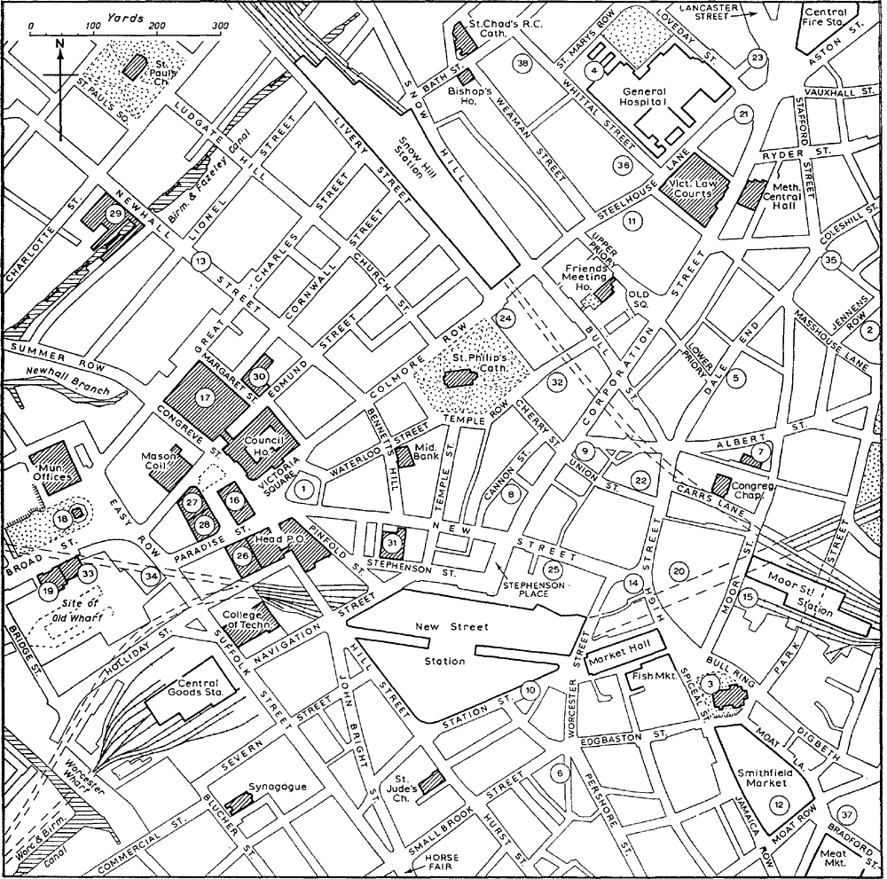
CENTRAL BIRMINGHAM, c. 1950
1. Site of Christ Church. 2. Site of St. Bartholomew's Church. 3. St. Martin's Church. 4. Site of St. Mary's Church. 5. Site of St. Peter's Church. 6. Site of St. Martin's Rectory. 7. St. Michael's R.C. Church (formerly New Meeting). 8. Site of Cannon St. Baptist Chapel. 9. Site of Cherry St. Wesleyan Methodist Chapel. 10. Site of Old Meeting. 11. Site of Ebenezer Congregational Church. 12. Site of Birmingham Manor House. 13. Site of New Hall. 14. Site of Leather Hall. 15. Site of Public Office. 16. Town Hall. 17. Council House Extension, incl. part of City Mus. and Art Gallery. 17. Hall of Memory. 19. Birmingham Municipal Bank. 20. Site of Court of Requests. 21. Site of Old Workhouse. 22. Site of General Dispensary. 23. Site of Lench's Almshouses. 24. Site of Bluecoat School. 25. Site of King Edward VI School. 26. Queen's College Chambers. 27. Public Library. 28. Birmingham and Midland Institute. 29. Mus. of Science and Industry (formerly Elkington's Wks.). 30. College of Arts and Crafts (formerly Sch. of Art). 31. Theatre Royal. 32. Site of Royal Hotel. 33. Masonic Temple. 34. Site of Birmingham Canal Office. 35. Site of Carless's Steelhouse. 36. Site of Kettle's Steelhouses. 37. Site of Town Mill. 38. Anderton Square.
The central area began to undergo a second phase of change about 1938 with the inauguration of the scheme to build a formal Civic Centre in and around Broad Street. The centre was still unfinished in 1961 and chiefly consisted at that date of a block of municipal administrative offices completed in 1939 (now known as Baskerville House), the Birmingham Municipal Bank, and the Hall of Memory. (fn. 129) After the Second World War the construction of the Inner Ring Road was planned to go much farther in removing old landmarks and imposing a new pattern of roads, road junctions, and public buildings on the centre of the city. It was designed as a dual carriageway, 110 ft. wide, with an extra lane for stationary vehicles. In its course it would cross all the main arterial roads leading out of the city and thus quicken the flow of through traffic, which had grown too heavy to be adequately served by the existing system of one-way streets, (fn. 130) as well as increase the extent of the central shopping area. The provision of subways and of viaducts over the minor intersecting roads would also ease the movement of traffic and of pedestrians. Work was begun on the road in 1957 and the first stretch, the Smallbrook Ringway and shopping centre, running from Horse Fair to Queen's Drive, was opened in 1960, and by 1961 had been extended to Carrs Lane. Progress was then being made, notably in the area of the Bull Ring, with the construction of the road and of the buildings to be erected along its route and on leasehold land at the rear of it, and it was intended that a fresh length of the road in Snow Hill should be ready early in 1962. (fn. 131)
The Outlying Parts of the 1838 Borough
When Birmingham became a municipal borough in 1838 the half of the ancient parish lying east of the line from Hockley Hill to Five Ways was almost all built over, while except around Soho the western half was almost entirely undeveloped and was still being used for agriculture. Also included in the borough in 1838 were three areas, outside the boundaries of the ancient parish, over which the town had spread: north-east, between the River Rea and the Hockley Brook; south-east, through Deritend and along Bordesley High Street, and south-west, between the Bristol and Hagley roads. (fn. 132)
The first two of these areas were in the ancient parish of Aston. That which lay along the spur of land in the angle between the Rea and the Hockley Brook was known as the township of Duddeston and Nechells, names by which the two manors comprising the area had been known from the 13th century. (fn. 133) There is no record of any village or hamlet at Nechells, the northern part of the area, before it was overrun by the town, and the tradition (fn. 134) that a village at Duddeston had been depopulated is unreliable. Dugdale mistakenly adduced a licence for an oratory at Nechells as evidence for the former existence of a 'pretty village' there, and understood the name Duddeston to imply 'a village of great antiquity'. (fn. 135) In 1730 there were four farms and a cottage in Nechells, and five farms and a few other houses at Duddeston. (fn. 136) The middle-class nature of the suburb of Ashted, (fn. 137) the first urban development in the area, seems not to have survived for long, probably as a result of the proximity, first, of the humbler residential district around Great Lister Street (fn. 138) and, later, of the railway and gas works. The Grand Junction railway line reached Vauxhall in 1837, (fn. 139) and soon afterwards there were extensive railway works and two gas works on the other side of the Rea. (fn. 140) Nechells was developed in the second quarter of the 19th century as an area of small working-class houses along the left bank of the Rea, (fn. 141) and by 1841 Duddeston and Nechells had a population of over 20,000 (see below, Table 2). For several years there was a strip of undeveloped land on the right bank of the Hockley Brook. In the eighties it was filled with railway lines and gas works, and the building of power-stations further marked the change in the area's character from residential to industrial. (fn. 142) Both Duddeston and Nechells began to undergo much rebuilding after the Second World War. (fn. 143)
Deritend has already been mentioned as an early suburb of Birmingham. (fn. 144) In many ways Deritend was related to Birmingham in the same way as Southwark to London. Administratively separate from it, Deritend's closest links were with Birmingham, and the foundation of a chapel at Deritend at the end of the 14th century (fn. 145) weakened its connexion with the parent parish of Aston. Since Deritend lay at the focal point of Birmingham's system of external communications it was natural that the town should grow outwards in this direction. By 1810 buildings had reached along Bordesley High Street as far as the junction of the Coventry and Stratford roads, and along the Stratford road about as far as Highgate Park. (fn. 146) The population of Deritend and Bordesley had passed 18,000 by 1841 (see below, Table 2). Deritend was an area of piecemeal development on small sites, in courts and narrow streets, while the proximity of the Warwick and Birmingham Canal encouraged the building of workshops and warehouses. The main changes in the area have been brought about by the gradual diminution of the Rea as a natural barrier and the widening of the main road. The principal industrial feature at the middle of the 20th century was the gas works and electricity station near the canal, between Adderley Street and the Coventry road. From this area in the middle of the 19th century buildings spread south along the Moseley road to cross the borough boundary on Balsall Heath and west along the Coventry road over Small Heath (at the far end of which the Birmingham Small Arms factory, built 1861, acted as a magnet) and Bordesley Green, making two arms of closely built workingclass houses. A railway station was opened at Small Heath in 1863. (fn. 147) Between Balsall Heath and Small Heath was the small valley of the Spark Brook, and this area, known as Sparkbrook, had been filled up with cheap housing by 1890. By the end of the century buildings reached almost to the edge of the River Cole, the city's boundary. (fn. 148) The systematic character of development in this area can be seen in the existing pattern of the houses there, and is reflected in the rapid rise of population in the sixties and later (see below, Table 2).
Edgbaston is remarkable for having retained most of the characteristics intended for it when it was developed as a suburb. The parish comprised 2,598 acres of undulating land drained by the Chad Brook, which divides the main part of the parish from Harborne and from the southern tip of Edgbaston, bounded on the south by the Bourn Brook. There appears to have been no rural village at Edgbaston: the parish was originally a chapelry of Harborne, its church standing beside, and presumably owing its foundation to, the manor house, (fn. 149) and in 1703 (before the formation of Edgbaston Park) the houses of the parish lay scattered around, most thickly near the crossing of the Chad Brook by the Harborne road. (fn. 150) The population rose rapidly in the first half of the 19th century, from 1,155 in 1801 to 3,954 in 1831. (fn. 151) The part nearest Birmingham between Edgbaston Park and Lee Bank Road, was partitioned into plots and built over in this period. (fn. 152) Sir Henry Gough, lord of the manor of Edgbaston, had contrived to avoid the building of factories or warehouses along the Worcester and Birmingham Canal, (fn. 153) foregoing any immediate profits for the sake of maintaining the residential value and character of the area. Moreover, the building leases that were granted precluded the denser development of the sites. In this way Edgbaston avoided the decline of all the other late 18th and early 19th-century suburbs of Birmingham from polite middle-class spaciousness and dignity to the noise and dirt of manufacture or the crowded closeness of an industrial population. The building of substantial houses in fair-sized gardens was continued along either side of the Hagley road and the Harborne road, reaching as far as the eastern end of Portland Road by 1863. (fn. 154) In the next twenty years, with an added incentive provided by Hagley Road railway station on the Harborne Railway (opened 1874), nearly the whole of the tongue of Edgbaston projecting north-west was built over in the same way, and a triangular area between Edgbaston Park and Harborne, with its railway station at Somerset Road (opened 1876) on the Birmingham West Suburban Railway, was developed. (fn. 155) With some further development in the early years of the 20th century along the north-west side of the Bristol road and at the extreme north-west tip of the parish, and with the building of the new university buildings (opened 1909) and the Queen Elizabeth Hospital (opened 1938), (fn. 156) Edgbaston achieved the appearance it presented in the middle of the 20th century, a leafy, low-density area close to the centre of Birmingham. In spite of the use of a few sites for tall commercial and residential buildings, it has retained much of its open space. Edgbaston has been called Birmingham's Belgravia, a description which indicates only its select residential character and its nearness to the centre.
Edgbaston, in 1838, comprised about half of the undeveloped land lying within the borough of Birmingham as then constituted, but the way in which it was developed did not allow it to accommodate more than a minute part of the overspilling population of the town. The western part of Birmingham ancient parish, formed by the districts now known as Rotton Park, Summerfield, Ladywood, Winson Green, Gib Heath, and Brookfields, comprised a large part of the remaining half of the undeveloped land. Ladywood, Winson Green, Gib Heath, and Brookfields lay along the lines of canal and railways and were developed first for industrial purposes, but by the middle of the 19th century small houses and various hospitals formed an important feature. By 1863 the north-west part of the borough, as far as Foundry Road and Bacchus Road, had been built over, and twenty years later buildings had reached the line of the railway between Smethwick and Perry Barr. Between 1854 and 1876 six passenger stations were opened in this part of Birmingham. (fn. 157) At Brookfields and Ladywood many working-class houses were built, and from 1841 the population of the two wards which these districts comprised rose steadily (see Table 2). There was a corresponding decline in the population of the central wards of the borough, (fn. 158) but it cannot be said that there was a movement in the population westwards for it is not possible to trace the movement of households or to discover whether new suburbs were populated predominantly by families formerly resident in central Birmingham or by families which had moved to the Birmingham area from elsewhere. Beyond Summerfield Park and the Rotton Park reservoir (built in connexion with the Birmingham Canal, and taking up very nearly the whole of Rotton Park) the land was gradually taken up for housing between 1900 and 1937. (fn. 159)
a Based on Census Reports, 1841-1911.
b Wards subject to intercensal boundary changes.
c No separate figures published.
d No earlier figures published.
The most important development scheme undertaken after the Second World War was the creation of the Redevelopment Areas. The redevelopment of 267 a. at Duddeston and Nechells proposed in 1937 was temporarily frustrated by the outbreak of war but in 1947 the city council completed the purchase of c. 1,400 a. in five areas - Duddeston and Nechells, Summer Lane, Ladywood, Bath Row, and Gooch Street - lying in a horseshoe shape round the centre of Birmingham and consisting largely of slum property and obsolete industrial and shop premises. Work was still proceeding in 1961 on the conversion of these areas into five self-contained 'new towns', to house communities of 6,500 to 15,000 people (fn. 160) and complete with shopping centres, open spaces, churches, schools, and other public buildings. (fn. 161)

GROWTH OF THE URBAN AREA
Expansion beyond the Borough Boundaries
The development of the outlying parts of the borough as constituted in 1838 was not enough to meet the demand for new industrial and residential sites. Outside the borough's boundaries the main areas of development in the middle years of the 19th century were Balsall Heath, Aston Manor, Lozells, and the salient of Handsworth parish between Birmingham and Aston parishes along Soho Hill. (fn. 162) All these areas lay along the routes leading out of Birmingham by road, canal, and railway. The last three formed a solid belt of urban development along the northern boundary of the borough, while Balsall Heath grew out from the town like a protruding limb along the Moseley road and the Birmingham and Gloucester railway. (fn. 163) This pattern of urban expansion was continued in the later part of the century: by 1890 buildings had grown up on either side of the Soho road as far as the limits of the modern city, and over the southern part of Handsworth parish as far as the London-Midland railway; building in the Aston Manor area had reached further afield and the suburbs of Gravelly Hill and Erdington had established themselves in a long arm up the road towards Sutton Coldfield; eastwards, the town extended across Washwood Heath and Saltley, and beyond Small Heath there was a small but well established industrial area at Hay Mills; and the urban area of Balsall Heath, which had become joined to Small Heath by the development of Sparkbrook, had stretched a long way south as far as Sparkhill and King's Heath. (fn. 164)
aBased on Census Reports, 1841-1911. The figures for Aston include, of the areas mentioned in the text, Deritend and Bordesley, Duddeston and Nechells, Aston Manor, Bordesley Green, Gravelly Hill, Erdington, Lozells, Small Heath, Sparkbrook, Saltley, Washwood Heath, and Ward End and Little Bromwich (see also Tables 2 and 4); those for King's Norton include Balsall Heath, Moseley, King's Heath, Stirchley, and part of Bournville; those for Yardley include Sparkhill, Hay Mills, and Hall Green; those for Northfield include Bournbrook, Selly Oak, and part of Bournville; those for Handsworth include Perry Barr (see also Table 5).
In the following twenty years the areas of greatest expansion were in the south-west, at Bournbrook, Bournville, Selly Oak, and Stirchley, and in the south-east at Acock's Green and South Yardley. Between these two areas many houses were built in the early years of the 20th century along the Stratford road as far as Hall Green. On the east of the town Ward End and Little Bromwich had been engulfed in the spread of housing by 1913. On the north there was little expansion during this period except that Gravelly Hill and Erdington grew outwards on both sides of the axis of main road and railway line. (fn. 165)
The development of new areas for residential purposes is reflected to some extent by the figures of population (see Table 3). The census figures do not, of course, give a complete picture, because at the same time as fields were being laid out in streets areas already built over were being more intensively developed and more thickly populated. The population of Duddeston and Nechells, for example, continued to increase until as late as 1901. (fn. 166) Moreover, the areas for which figures are available extend well beyond the areas of new urban development. In Handsworth, for example, the population increased every ten years by 40 per cent. or more between 1851 and 1901 without any great extension of the urban area. (fn. 167) Balsall Heath, the part of King's Norton parish closest to Birmingham, accounted for a little under two-thirds of the population of King's Norton in 1891; twenty years later, when the urban area had spread over Stirchley, Moseley, and King's Heath, it accounted for less than half although its own population had risen from 30,581 to 39,884. (fn. 168)
Two phenomena hastened the process of urban extension. One was the readiness of manufacturers to build or develop their factories beyond the edges of the developed area, (fn. 169) where land was cheaper and space more ample. The pattern of transport services encouraged this tendency, for it was more important for industry to be sited near a railway or canal than near the centre of the town. The other phenomenon was the desire of the workers in these factories to move away from the crowded, noisy, and often squalid areas of the centre of Birmingham - and some were forced to move by street improvements - into new houses built conveniently nearer to the out-of-town factories. (fn. 170) This double process is illustrated by the examples of Hay Mills, Bournville, and, in more recent times, Longbridge.
As the town expanded, earlier rural communities were swallowed up. The expansion of Birmingham has been a relatively simple growth outwards from the centre, for of the villages around Birmingham which are now included in the city none developed as a town or urban centre in its own right, but mainly as an offshoot or satellite. Thus in each case a rural pattern was overlaid, often quite rapidly, by an urban one. The process of change often displayed several phases, and the suburbs of Birmingham afford many examples of successive 'in-filling'. In the first phase merchants and manufacturers acquired substantial plots for their suburban houses on agricultural land or in the grounds of country houses; in their turn the large suburban houses were surrounded by, or were demolished to make room for, smaller villa-type houses; and in some instances these villas were themselves removed and replaced by rows of small modern suburban houses. One or more of these phases occurred in all Birmingham's suburbs, with a number of local variations, and the first suburban use of a particular area usually had a strong influence on the later and quite different type of development in the area. The change in suburban land-use often depended on such fortuitous factors as the fortunes and ambitions of the families who first inhabited the suburb, the proximity of a railway station, the enterprise of local builders and building societies, or the terms of a conveyance. In this Birmingham is like many other industrial towns, but the size of Birmingham and the great demand for building sites there make it a striking example. An account of the historical topography of those parts of Birmingham not already described, that is, of the areas joined administratively to Birmingham since 1838, can most conveniently be covered by describing each in turn, as is done in the following section.
Areas added since 1838
The town's rise and importance had been acknowledged by the conferring in 1889 of the title city, and the spread of the urban area beyond the limits of the borough as constituted in 1838 was given some degree of administrative recognition in 1891 by the inclusion within the city of Harborne, Balsall Heath, Saltley, and Ward End. (fn. 171) This extension of the city boundaries did not cover more than a small part of the area which had developed as Birmingham's suburbs, and the question how far the city boundaries should extend had for some time been disputed. The city councillors appeared to the residents of the districts which they planned to annex in the likeness of a military staff preparing an invasion. The extension of 1891 for a time satisfied the desire for administrative growth, but the resolution taken by the parish council of Quinton for inclusion in the city, which was put into effect in 1909, was the prelude to a much greater expansion. (fn. 172) By the Greater Birmingham Act of 1911, Handsworth, Aston Manor, and Erdington on the north, Yardley on the south-east, and much the greater part of King's Norton and Northfield on the south were included in the city. This extension gave to the city boundaries something approximating to their present outline. This was finally achieved by 1931 with two smaller additions to the city's area. (fn. 173)
The 80 square miles of the city's area comprise the central area (already described), the older suburbs in the immediate neighbourhood of the central area (large parts of which lay within the borough of 1838 and are therefore described above), and the newer suburbs and industrial localities nearer to the city's boundaries. These three divisions of the city have often been characterized as the Inner, Middle, and Outer Rings. (fn. 174) In the last there still remained in 1961 a few areas, notably in the south-west, not developed for industrial or residential purposes and still used for agriculture. In the seven ancient parishes of Aston, Sheldon, Yardley, King's Norton, Northfield, Harborne, and Handsworth, which together with the ancient parishes of Birmingham and Edgbaston make up nearly the whole of the area of the modern city, rural villages and hamlets have developed gradually into well populated suburbs. Other localities, with a much shorter residential history, have developed rapidly, and often with startling speed, or have been part of the steady, but seldom slow, expansion outwards from the central area.
ASTON, the largest of these ancient parishes in area (14,074 a.), also included the largest number of old rural hamlets and showed the most marked increase in population in the 19th and 20th centuries. It now forms the north-east quarter of the city, lying on the heathland north and south of the Tame below its confluence with the Rea. The southern boundary is formed by the Cole, and part of its western boundary by the Rea and the Tame before they join. The western boundary at about its middle makes a salient across the Tame between Perry Barr and Birmingham. (fn. 175) From 1821 to 1851 the population of Aston rose almost as sharply as that of Birmingham ancient parish, and from 1851 it rose even more sharply so that by 1891, when the population of central Birmingham was already falling, Aston had surpassed Birmingham in population. Between 1841 and 1911 over half the population of Aston ancient parish lived in the two townships included in the borough of Birmingham in 1838, Duddeston and Nechells, and Bordesley and Deritend (see above, Tables 2 and 3).
The increase in population of the part of Aston ancient parish remaining outside the borough of Birmingham in 1838 (see Table 4) gave rise to various changes in the administrative areas, before the inclusion of most of the area in the city of Birmingham. The parish was anciently in Warwickshire. Under the Public Health Act of 1872 urban sanitary authorities were set up for Aston Manor and Saltley (neither having previously had a local board of health), which therefore became urban districts under the Local Government Act of 1888. (fn. 176) The remainder of Aston parish outside Birmingham formed Aston Rural Sanitary District. (fn. 177) The whole of Aston ancient parish, including those parts of it which had been taken into Birmingham, remained meanwhile a single civil parish until, three years after the inclusion of Saltley and Ward End in Birmingham in 1891, it was divided into the civil parishes of Aston (i.e. the parts of Aston ancient parish which had been included in Birmingham), Aston Manor, Erdington (which at the same time became an urban district), Castle Bromwich, and Water Orton, the last two becoming part of Castle Bromwich Rural District. (fn. 178) Aston Manor and Erdington included, respectively, the districts known as Lozells and Witton. Aston Manor became a municipal borough in 1903 which, with Erdington Urban District, was abolished in 1911 when these two areas were included in the city of Birmingham. (fn. 179) Castle Bromwich Rural District was abolished when the western and southern parts of Castle Bromwich civil parish were included in the city in 1931. (fn. 180)
The parish church and Aston Hall (the manorhouse) are on the south side of the Tame between Perry Barr and Birmingham. There is no evidence of there ever having been a substantial village there. Although the parish church and Aston Hall made it to some degree the focal point of the parish it was far from the geographical centre, and the existence of other estates and settlements of comparable size - Deritend, Castle Bromwich, Water Orton, and (for a short time at least) Ward End having their own chapels by the 16th century (fn. 181) - reduced its importance as the eponymous vill of the parish. A map of 1758 marks only a small number of houses around the church, at the north-east corner of Aston Park. (fn. 182) The village, however, was only two miles from the middle of Birmingham, and lay just off the Lichfield road, alongside which in the 1780s the Birmingham and Fazeley Canal was built. (fn. 183) The residential development of Nechells in the second quarter of the 19th century (fn. 184) brought the town close to Aston Manor on its south-east, and the second quarter saw Birmingham spread northwards from Great Hampton Street and across Birmingham Heath into the western tip of Aston parish, the district known as Lozells which lies west-south-west of Aston Park. (fn. 185) Lozells, like Nechells, was laid out in close streets of small houses. By 1863 a few streets, on a slightly larger scale, had been marked out immediately south of Aston Park, (fn. 186) and by the eighties there were houses on the north side also, (fn. 187) between the park and Witton station (opened 1876). (fn. 188) The General Electric Company acquired land at Witton in 1899, and in 1901 began building its large factory, (fn. 189) together with houses for its workers, between the railway line north-east of Aston Park and the Tame Valley Canal beyond, thus completing the process by which Aston Manor (by which name the district became known) was overrun by the urban area. (fn. 190)
a Based on Census Reports, 1841-1921.
b No figure for this precise area was published in 1921.
The district known as Witton (including Upper Witton) derives what unity it has from the preConquest estate which lay between the Tame and the Hawthorn Brook, (fn. 191) running through Witton Lakes Park and Brookvale Park. In 1730 it contained 22 farms and three cottages, (fn. 192) apart from Witton Hall (fn. 193) at the north-west end of Brookvale Park. Part of Witton is still undeveloped, but the area is by no means homogeneous: the Tame Valley Canal divides the G.E.C. factory and the residential estate beside it from a stretch of undeveloped land, north of which is the housing estate of Upper Witton (built between the two World Wars) and the Witton Cemetery. North-east again, between the cemetery and Short Heath, there is more undeveloped land and the recent Wyrley Birch housing estate of 30 acres which includes a sixteen-story block of flats. (fn. 194)
East of Witton and Aston Manor, and north of the Tame, was the largest of the townships that made up the ancient parish. Erdington village itself lay on the Lichfield road midway between Birmingham and Sutton Coldfield. (fn. 195) In the 14th century it appears to have been one of the two largest hamlets in Aston parish (Castle Bromwich being the other), (fn. 196) and there is some evidence that a minor metal-working industry had been established there by the 16th century. (fn. 197) Erdington, however, was close enough to Birmingham to be eclipsed, although too far away to develop as a populous residential suburb until modern transport facilities had been introduced. It had grown sufficiently by about 1820 to merit its own church, (fn. 198) but the earliest part to develop was Gravelly Hill, south-west of Erdington village, where in the middle of the 19th century a string of middle-class houses stretched along the road climbing up from the Tame at Salford Bridge. (fn. 199) In 1862 the Sutton Coldfield railway was built and stations were opened at Gravelly Hill and Erdington, (fn. 200) resulting in more extensive building around each of them. By the eighties only a short stretch of the main road between Gravelly Hill and Erdington remained undeveloped; by the end of the century this had been filled and building was extending away from the main road on either side, south-east over Moor End Green, and north-west towards Stockland Green (where already a few houses had been built) and Short Heath. The first residential roads on Short Heath were laid out before the First World War, and between the wars houses extended as far as College Road, the old boundary between Aston and Handsworth parishes and between Warwickshire and Staffordshire. South from Erdington houses were built along Wheelwright Road, and around the junction of Tyburn Road and Bromford Lane, early in the 20th century. The land north of Tyburn Road between Bromford Lane and Pype Hayes Park was taken up by housing estates in the thirties. South of Tyburn Road, and between the Birmingham and Fazeley Canal and the London Midland railway line, in an area well served by transport facilities and preserved for later development first by its liability to flooding and subsequently by its use for sewage farming, several industrial sites have been developed (of which Fort Dunlop is the largest and Bromford Wire Works the oldest), which have been able to draw most of their labour from the housing estates north of Tyburn Road. Between Sutton Road and the railway the Lyndhurst housing estate was developed by the corporation c. 1958. (fn. 201) In the north and east of Erdington the only considerable area remaining undeveloped in the middle of the 20th century was Pype Hayes Park, surrounding the Hall, and some land northwest of it, all lying between the Chester road and the city boundary. (fn. 202) Despite the amount of land that has been used for houses Erdington nevertheless had in 1931 and 1951 a lower number of persons to each acre than nearly all the other parts of the city. (fn. 203)
South and east of the Tame and the Rea, Aston parish had for long been divided into a series of townships. Farthest upstream were Deritend and Bordesley which, included in the borough of Birmingham from 1838, are described above. (fn. 204) Then came Saltley (which included Washwood Heath) and the township of Ward End and Little Bromwich. Beyond Ward End was Castle Bromwich, of which only part has been included in Birmingham, and beyond that again Water Orton, which has remained wholly outside Birmingham. (fn. 205) Saltley centred on a small hamlet east of Saltley Bridge, which linked it with Duddeston on the other side of the Rea, and by 1760 there were a few larger houses on the western edge of Washwood Heath. Ward End and Little Bromwich on the other side of the Wash Brook, contained at that time only scattered houses. (fn. 206) During the 18th century a few of the wealthier Birmingham merchants had bought or built houses in these two areas, (fn. 207) but by the second half of the 19th century the railway works which had been built on the right bank of the Rea and the working-class houses in compact rows which extended increasingly further east over the fields of Saltley, and especially around Adderley Park station (opened 1860), were beginning to threaten the seclusion of these retreats. (fn. 208) By 1890 three streets of small houses had been built in the neighbourhood now called Little Bromwich, the southern tip of the township of Ward End and Little Bromwich. (fn. 209) Before the First World War about a dozen streets of working-class houses were built east and south-east of Ward End Park, in the north end of the township, eclipsing the small suburban village which had grown there in the early 19th century, and separated by only a narrow stretch of open ground from the houses which had been built south of Ward End Park right up to the boundary between Saltley and Ward End along the Wash Brook. (fn. 210) The building of railway works and the Wolseley motor-car factory north of Washwood Heath, the extension of the residential area north and east of Ward End Park, and the building of a housing estate (fn. 211) and an isolation hospital (fn. 212) in the angle between the London-Birmingham railway line and the River Cole completed the urban pattern which characterized Saltley and Ward End in 1950. Since that time corporation houses and blocks of flats have appeared on the Ward End Hall site near St. Margaret's Church.
The old boundary between Ward End and Castle Bromwich ran from Bromford Bridge on the Tame to Stechford Bridge on the Cole, along Bromford Lane and Stechford Lane. (fn. 213) The western and southern part of the former civil parish of Castle Bromwich, incorporated in the city of Birmingham in 1931, does not include the village and church. (fn. 214) Along the south bank of the Tame between Bromford Bridge and Castle Bromwich Bridge is the Birmingham Race Course (opened 1895); (fn. 215) south of this is Hodgehill Common around which a large housing estate grew up in the thirties, extending a little way over Buckland End to the south-east. After the Second World War the Buckland End estate was enlarged further and the Firs estate, which included ten tower blocks of flats, schools, and shops was built to the south of the race course. The largest of the new housing schemes within the city boundaries, forming a self-contained neighbourhood, lies further west at Shard End where previously there had been only fields and a group of farm buildings. Further west again, beyond the boundary, the Kingshurst Hall estate of 260 acres was being developed c. 1960 as part of Birmingham's overspill scheme. (fn. 216) Castle Bromwich airfield (opened 1914), (fn. 217) the exhibition buildings of the British Industries Fair (opened 1920), (fn. 218) and the railway station (opened 1842), (fn. 219) all lie north of the Tame; they were not in fact in Aston ancient parish and form that part of Minworth civil parish (in Curdworth ancient parish) which was added to the city of Birmingham in 1931. (fn. 220)
South from Castle Bromwich lay the ancient parish of SHELDON. (fn. 221) The greater part of this parish, including the old village centre but excluding the north-east tip and the area south of the Coventry road, was transferred, together with that part of Solihull lying north of the Coventry road, from Warwickshire to Birmingham County Borough in 1931. (fn. 222) For a long time Sheldon remained comparatively unaffected by the proximity of Birmingham: the number of inhabitants, 423 in 1821, remained constant until the early 20th century, and in 1921 was still only 451. It had risen slightly by 1931 to 526. Of these 465 were in the part of the parish added to Birmingham. (fn. 223) In the thirties large housing estates were built north of the Coventry road at Lyndon Green and Wells Green, eclipsing the old village by the parish church, while a shopping centre grew up along the Coventry road itself. After the Second World War there was further residential building north and south of the London Midland railway line. (fn. 224) Sheldon is as far from the centre of the city as any other part of Birmingham except Northfield and Longbridge, but the distance is made easier by trains from Lea Hall station (opened 1939) and by frequent buses along the Coventry road. (fn. 225)
Between Sheldon and Bordesley is the north-east end of YARDLEY, (fn. 226) an ancient parish long and thin in shape, stretching 7 miles from north-east to south-west and 2½ miles across at its widest point, the River Cole forming its north and north-west boundary and dividing the southern portion of the parish in two. It was transferred from Worcestershire to Birmingham County Borough under the Greater Birmingham Act of 1911, and forms the south-east edge of the city. (fn. 227) Three railway lines pass through the parish, the London Midland line crossing the north-western end with stations at Stechford and Lea Hall (opened 1844 and 1939 respectively), the Great Western line crossing the middle with stations at Tyseley and Acock's Green (opened 1906 and 1852 respectively), and the line to Stratford-on-Avon branching off at Tyseley to run south along the axis of the parish through stations at Spring Road (1919), Hall Green (1908), and Yardley Wood (1908). (fn. 228) In 1871 the ease of railway communication with Birmingham was thought to be partly responsible for the increase in the population of the parish, which, after a slow increase from about 2,000 in 1801, began to grow more rapidly in the fifties. The other reason given for the increase was that Yardley was a 'favourite locality' with Birmingham businessmen. (fn. 229) From the seventies and eighties, however, the businessmen began to be ousted by industry and industrial housing. The population nearly doubled itself every ten years between 1871 and 1911 (see above, Table 3). By the eighties industrial sites, with houses for the workers, had developed by Stechford Bridge (on the northern edge of the parish and a mile north of the old village of Yardley), on the Coventry road at Hay Mills, and on the Warwick road at Greet, while around the junction of the Warwick and Stratford roads at Sparkhill working-class houses were spreading from Sparkbrook and Balsall Heath. At Acock's Green, on the other side of the parish from Sparkhill, an industrial and working-class neighbourhood began to develop after the opening of the railway station in 1852, where the transport facilities it afforded were supplemented by the nearby Warwick and Birmingham Canal. (fn. 230) From these districts buildings spread out in the later 19th century in straggling shapes along the lines of existing roads: by the end of the century Stechford had become linked to Yardley village in this way, Hay Mills (which had spread laterally also) and Acock's Green were reaching out towards South Yardley where a suburban village had grown by the eighties, and the Sparkhill salient reached as far as Springfield. Further extension in the years preceding the First World War linked Yardley village, South Yardley, Hay Mills, Acock's Green, and Greet, forming a network of residential areas along the roads between those places, and houses reached along the Stratford road to the old hamlet of Hall Green, which itself extended south-west towards Yardley Wood station. After the First World War the whole area of the ancient parish was subjected to a more concentrated residential development, so that by 1937 only small areas of undeveloped land remained, most of them bordering the River Cole. (fn. 231)
KING'S NORTON, (fn. 232) an irregularly shaped parish of over 12,000 acres formerly in Worcestershire, (fn. 233) lay east and south-east of Yardley. Its northeastern end reached up between Yardley and the Rea to within a mile of the centre of Birmingham; due south and south-west the parish extended as far as 8 miles from the Bull Ring. The northern and western arms of the parish lay roughly along the line of the Rea, which provided the route for both the Worcester and Birmingham Canal and the Birmingham and Gloucester Railway. (fn. 234) Balsall Heath, the part of the parish lying nearest to Birmingham, began to be built over in the second quarter of the 19th century: (fn. 235) the well drained, comparatively infertile land afforded good sites for working-class houses. In 1862 a local board of health for Balsall Heath was set up under the Act of 1858, and the area became an urban sanitary district under the Act of 1872. (fn. 236) By 1863 the urban spread had reached south along the railway line as far as Brighton Road, (fn. 237) where a station was opened in 1875, (fn. 238) and in 1891 Balsall Heath was included in Birmingham city. (fn. 239) By that time most of the area had been built over, and in the next ten years the remaining land, near Calthorpe Park, was used up. (fn. 240) Balsall Heath provides an example of 19thcentury urban housing at its cheapest, in marked contrast with the area of Moseley, immediately south. There, the land east of the railway line and the Alcester road was developed, following the opening of Moseley station in 1867, (fn. 241) as a comparatively spacious middle-class suburb, which seems to have imitated on a more modest scale some of the characteristics of Edgbaston. Continual in-filling has increased the density of the houses without lowering the social standing of the suburb. The western half of Moseley, bordered by Cannon Hill Park and Highbury Park and developed mostly in the last decade of the 19th century, contains a high proportion of unbuilt land between widely spaced, tree-lined roads. (fn. 242) South of Moseley the railway line passes through King's Heath, where a station had been opened in 1840, (fn. 243) the year the railway was opened; around it and south of it as far as Alcester Lanes End a few streets were laid out in the middle years of the century. (fn. 244) Development in this area was sporadic and comparatively slow. Most of the building south and south-west of King's Heath was carried out in the early years of the 20th century. There were suburban housing estates at Hazelwell (where a station had been opened in 1903) (fn. 245) and at Brandwood End by the First World War, and between the wars a belt of houses was built between Alcester Lanes End and King's Norton village, with another belt across Highter's Heath; (fn. 246) even so, there remained several areas of undeveloped land after the Second World War. Millpool Hill, a corporation housing estate, was built at Highter's Heath while a much larger one on a hillside site at Walker's Heath includes tower blocks of flats at its highest point. King's Norton village retained many of its rural features and was still easily recognizable as an older village centre, but just as it had become linked between 1918 and 1939 to the urban spread along the Alcester road so had it been reached by the extending frontier of the town along the Pershore road. North of the village was Bournville, (fn. 247) and north-east Stirchley, which, extending along the Pershore road to Cotteridge, grew in the last decade of the 19th century into a minor suburban centre served by stations at Lifford (opened 1840), King's Norton (1849), and Bournville (1876). (fn. 248) South-west of King's Norton village the parish was largely undeveloped until after the First World War, but since then large housing estates have been built over about a third of the area. (fn. 249) The inhabitants were drawn there largely by the opportunities for work provided by the Austin motor-car works at Longbridge, established there in 1905 and greatly extended during the First World War and subsequently. (fn. 250) Hawkesley Farm housing estate, built in this district in 1958, incorporates the moated site of the farmhouse in its layout. (fn. 251) Except for Balsall Heath, which had already become part of Birmingham, King's Norton parish formed part of the Urban District of King's Norton and Northfield, created in 1898, and in 1911 all the King's Norton part of this urban district except for Wythall and the small area of Rednal was added to Birmingham. Wythall, which formed the south-eastern part of King's Norton ancient parish and has remained largely rural in character, became a separate civil parish in 1911. (fn. 252)
The ancient parish of NORTHFIELD, (fn. 253) covering 6,011 acres, was also originally part of Worcestershire, its northern boundary with Harborne (formerly in Staffordshire) and Edgbaston (formerly in Warwickshire) being marked by the Bourn Brook, part of its eastern boundary with King's Norton by the Rea and Griffin's Brook. Except for under 200 acres of the north-west tip of the parish, which was added to Lapal civil parish, Northfield was included in Birmingham in 1911; from 1898 until then it had been part of the Urban District of King's Norton and Northfield. (fn. 254) The old parish church stands 5½ miles from the centre of Birmingham and half a mile from the southern boundary of the parish, with the old village grouped around it. A subsidiary settlement developed north and west of the village on the Bristol road, and by 1840 had grown larger than the original village. (fn. 255) The Worcester and Birmingham Canal, opened in 1815, cuts across the north-east corner of the parish, making a junction at Selly Oak with the Selly Oak branch of the Dudley Canal, opened in 1801. This branch runs along the northern edge of the parish, entering the Lapal tunnel (fn. 256) near the ruins of Weoley Castle at California, where a small colony of brickmakers was established after 1840. (fn. 257) Until 1876 the only railway in the parish was the Birmingham and Gloucester line, which cuts across its southern tip. In 1876 the Birmingham West Suburban Railway was built through Selly Oak and a station was opened there in the same year. (fn. 258) It was natural that the first part of the parish to undergo suburban development should be Selly Oak, where road, railway, and canal meet; it is also the part of the ancient parish closest to central Birmingham. By 1882 industrial buildings and working-class houses had been built along the Bristol road around the railway station and the canal junction, with a district of larger, middle-class houses at Selly Park between the Bristol and Pershore roads. In the next twenty years houses were built along the Pershore road for almost the whole of its length in Northfield, and from Selly Oak working-class houses extended east and south-east over the area called Bournbrook. (fn. 259) In this period, however, the Bournville estate began to rival Selly Oak as the main area of suburban development. A station had been opened at Bournville in 1876, (fn. 260) and in 1879 the Cadbury brothers built a new factory there. The building of houses followed the building of the factory, and by 1900, when the Bournville Village Trust was founded, the estate had grown to 330 acres containing 313 houses. From the start, the development of the estate, which by 1939 stretched to over 1,000 acres, was carefully planned, and it played an important part in the growth of the idea of the 'garden suburb'. (fn. 261) The result of building in Selly Oak and Bournville can be seen in the increase of the population of the whole parish from nearly 10,000 in 1891 to over 31,000 in 1911. (fn. 262) By the First World War almost the whole of the eastern part of Northfield parish had been built over. In the central and western part there had been very little building by that time. (fn. 263) Northfield village, where a station was opened in 1869, (fn. 264) had grown slightly and there had been some building along the Bristol road west of the village: by 1840 there was a small hamlet at Bartley Green, where in that year a chapel of ease was consecrated; (fn. 265) and north-west of Bartley Green there was a row of cottages by 1840 at Moor Street, just inside the parish boundary. (fn. 266) Between the wars there was steady development of the western part of the Bournville estate in the centre of the parish, and in the thirties large housing estates were built in the north at Weoley Castle and in the south-west beyond Northfield village. The undeveloped land between these two areas at Shenley Fields and in the north-west corner of the parish at Bartley Green began to undergo suburban development after the Second World War. (fn. 267) The chief corporation housing estates are at Ley Hill, Bangham Pit, Woodcock Hill, and Long Nuke Road in the west and at Wychall Farm, Bunbury Road, and near Staplehall Farm Recreation Ground in the east.
HARBORNE ancient parish formed an arm of Staffordshire projecting between Warwickshire and Worcestershire. Smethwick, the northern part of the ancient parish, became a separate civil parish in 1894 and, remaining outside the city of Birmingham, a separate county borough in 1906. (fn. 268) The southern part (the whole of the area now known as Harborne), which was included in the city of Birmingham in 1891 (fn. 269) and for which a local board of health had been set up in 1864, (fn. 270) contains just under 1,500 acres. (fn. 271) Its southern boundary is formed by the Bourn Brook, its eastern boundary by Metchley Lane and the Chad Brook, and its northern boundary (separating it from Smethwick) by the Hagley road. (fn. 272) This area thus forms a spur between the valleys of the Bourn Brook and the Chad Brook. The eastern part around the modern High Street (formerly called Heath Street) comprised Harborne Heath. The north and northwestern parts appear to have contained much woodland, from which names like Ravenhurst Road, Beech Lanes, and Lordswood Road are survivals, and indeed Lords Wood occupied about 200 acres until in the late 19th century the land began to be used for building. The parish church stands on high ground a little south of the centre of Harborne, and it is probable that the earliest settlement grew up there. Between 1790 and 1834 a number of small houses were built there, (fn. 273) but several have been demolished since that time. In the late 18th century the village had little in the way of a centre, but houses were beginning to string out along High Street, from the junction with Lordswood Road to Harborne Heath, and on this comparatively unproductive land suburban villas were built, especially between the 'King's Arms' at the junction with Lordswood Road and the junction with Moor Pool Lane (now Ravenhurst Road), and along Greenfield Road. (fn. 274) At the same period larger houses outside the village were built by or sold to some of the wealthier merchants of Birmingham: Harborne Manor, Tennall House, and the house which became known from its new owner as Welch's (or Welsh) House changed hands, (fn. 275) and Harborne House (now Bishop's Croft) and Metchley Abbey are among the houses built in the late 18th and early 19th centuries. The increase in the population of Harborne in the 19th century was less remarkable than in any comparable part of the modern city of Birmingham. From 1,178 in 1801 it rose to 1,637 in 1841, (fn. 276) and then rather more rapidly but nevertheless steadily. (fn. 277) The early increase was housed mainly in the area between High Street and Greenfield Street, and from there houses spread north and west across Harborne Heath. The opening of the Harborne Railway, with its terminal north of High Street, in 1874, (fn. 278) encouraged the northward expansion of the village. In the next ten years houses were built north-west from High Street along Lordswood Road and Court Oak Road, and west towards Hart's Green. (fn. 279) At Hart's Green there were a few cottages in 1790, (fn. 280) and beyond, at Camomile Green, there had grown a small community of nailmakers. (fn. 281) This was but one of several small metal-working trades practised in Harborne in the earlier 19th century; at that time the inhabitants were by no means entirely dependent on employment offered in agriculture or by Birmingham, although a number of craftsmen working in Birmingham lived in Harborne (fn. 282) and Harborne laundries took washing from Birmingham - particularly, perhaps, from Edgbaston. (fn. 283) This degree of independence during the expansion of Harborne village in the middle of the 19th century may account for the relatively integrated character of the now suburban village, but competition from Birmingham and Smethwick workshops and the absence of any large-scale enterprises in Harborne led to the abandoning of local industry; and since the last quarter of the 19th century Harborne's development has been almost exclusively that of a suburban dormitory. The formation in 1907 of Harborne Tenants Ltd., a building society in which the householders held part of the capital and which developed the land in the angle between High Street and Lordswood Road, gave further impetus to the growth of Harborne as a favoured residential suburb. (fn. 284) By the First World War about half the area of Harborne had been built over. In the thirties a municipal housing estate was built over most of the northern part of Harborne, which except for a few houses by the Hagley road at Beech Lanes and by the 'King's Head' (the inn itself was there as early as 1790) (fn. 285) had remained undeveloped. In the southern part wide stretches of open land have been retained as golf courses. (fn. 286) On its western side Harborne merges into Quinton, an area of 838 acres which was formerly part of Halesowen parish in Worcestershire. It became a separate civil parish in 1894, and in 1909, following a resolution by the parish council, became part of the city. (fn. 287) Although Quinton was in a different county and parish from Harborne until its inclusion in Birmingham, its development as a suburb has been almost entirely as an extension of Harborne. In the middle of the 19th century there was a small settlement at Quinton on the Hagley road at the point where it leaves the boundary of modern Birmingham. This remained isolated from Birmingham until in the decade before the Second World War houses spread westwards from Harborne into Quinton, leaving only the southern and western edges of the area undeveloped. (fn. 288)
The ancient parish of HANDSWORTH, which was formerly part of Staffordshire and now constitutes the north-western corner of the city of Birmingham, covered an area of 7,752 acres lying in roughly equal portions north-east and south-west of the Tame, on land that rises from the river valley (at the 300 ft. level) to 550 ft. in the extreme northeast and south-west corners of the parish. The boundaries of the parish are mostly marked by rivers and roads: the northern part of the parish was bounded by the Queslett road, the Chester road, and College Road from its junction with Kingstanding Road, and from that junction to the Tame the boundary followed the line of the Rycknield Street; the Hockley Brook marks part of the southern boundary, and the Tame, before and after running across the middle of the parish, marks part of the western and eastern boundaries; the remainder of the western boundary is marked by Park Lane. The parish fell naturally into two divisions, the Handsworth division (3,665 a.) south-west of the Tame and the Perry Barr division (4,087 a.) north-east of it. (fn. 289) An urban sanitary authority was set up for the Handsworth division in 1874, (fn. 290) and the area became an urban district under the Local Government Act of 1888. (fn. 291) This urban district was incorporated into the city of Birmingham in 1911, (fn. 292) and comprises Handsworth, Sandwell, and Soho wards. (fn. 293) Perry Barr, which had its own churchwarden by 1823 (fn. 294) and became a separate civil parish in 1862, (fn. 295) came under West Bromwich Rural District until Perry Barr Urban District was created in 1894. (fn. 296) In 1928 a little less than 700 acres at the west end of Perry Barr was added to West Bromwich and a narrow wedge of about 300 acres along the Chester road to Sutton Coldfield, the remainder becoming that part of Birmingham which is now Perry Barr and Kingstanding wards. (fn. 297)
The names of Handsworth parish present some difficulties. Handsworth is the name both for the whole ancient parish and for the southern division or township. The name for the northern township, Perry Barr, appears to have developed as the result of a confusion between the two estates which it comprised, Perry, and Little (or Parva) Barr. These two manors had been closely associated - in 1272 the building of a fence in Perry was said to have injured a free tenement in Little Barr, (fn. 298) and in 1327 and 1332 the taxpayers in the two manors were listed together (fn. 299) - and at the end of the 14th century they were held together. (fn. 300) A court roll of 1459-61 treats them as one manor, (fn. 301) and the identification of the two was such that by the 18th century the established form in conveyances was 'Perry Barr or Pury Barr or Parva Barr'. (fn. 302) The name Little (or Parva) Barr dropped out of use, Perry Barr being used instead for a time to describe the locality, (fn. 303) and Perry being used for the small settlement just north of Perry Bridge and near Perry Hall and Perry Mill. Perry Barr, however, was used also for the whole area north of the Tame, and is still the name of a municipal ward and a parliamentary division which do not extend south of the river; (fn. 304) but when a railway station was opened in 1837 on the south side of the river it was named Perry Barr, (fn. 305) and by a process of attraction the name has come to be used for the locality immediately north-east of the station, on the opposite side of the river from Perry. (fn. 306) Hamstead is an indeterminate area lying on both sides of the Tame and partly inside and partly outside the modern city. (fn. 307) The original settlement called Hamstead was probably north of the river, for in the early 13th century an estate in Hamstead (later described as a manor) was held of Perry manor, which appears to have been limited to the northern banks of the Tame. A different estate, known for a time as Hamstead manor, which lay south of the river and centred on Hamstead Hall, was part of Handsworth manor. (fn. 308)
On either side of the Tame were meadows, and, beyond them, arable fields which were once open but were mostly inclosed in the 16th and 17th centuries. (fn. 309) The southern part of the parish, along the Holyhead road and Heath Road, and the northern part of Perry Barr township were relatively high and barren, and formed Handsworth Heath and Perry Common. (fn. 310) South of Hamstead Bridge a considerable area of woodland was whittled away in the second half of the 19th century to make room for the residential area still known as Handsworth Wood. (fn. 311) West of this was a park, perhaps that owned by the lords of Handsworth manor in the 13th century; (fn. 312) from the 16th century there was a park attached to Hamstead Hall, (fn. 313) and the name survives in Park Farm; the park had been disparked by 1798, (fn. 314) and where the land has not been built over it is now used for agriculture and as a golf course (fn. 315)
Before suburban development took place there, the population of Handsworth and Perry Barr lived in widely dispersed farms and cottages, without a village centre. (fn. 316) There was a number of groups of dwellings, hardly large enough or concentrated enough to rank as hamlets, on the Holyhead road, at Birchfield End, Perry, Old Oscott, Queslett, Hamstead, and (outside the modern city boundary) at Newton End; near the church, at the centre of the southern division of the parish, were the rectory and a few cottages. (fn. 317) From the 16th century the mills along the various water-courses of the parish afforded opportunity for minor industry. (fn. 318) The establishment of Matthew Boulton's factory at Soho in the years 1761-4 began a new phase in Handsworth's history, as in England's, (fn. 319) but it was rather the fact that he and James Watt made their homes there (fn. 320) that indicated the lines of Handsworth's modern development. At about this time some large houses were being built nearby on Handsworth Heath. The inclosure of most of the heath in 1793 encouraged further building there, and by 1840 the southern part of the parish, from Birchfield Road along Heathfield Road and the Holyhead road to Rookery Road, had become a suburb with the same sort of social standing as Edgbaston, (fn. 321) though without Edgbaston's safeguards against future degeneration. In the next twenty years the area of suburban development in Handsworth extended very little, though the houses within it became more numerous. (fn. 322) The opening of Perry Barr station (1837) (fn. 323) and Handsworth and Smethwick station (1854) (fn. 324) encouraged the northward and westward expansion of this area. By 1888 the area of suburban development covered about half of Handsworth Urban District, reaching north through Handsworth Wood and as far as Perry Bridge: in these districts the houses were mostly large and widely spaced, but along the Holyhead road and near Soho Park (by then built over) such houses had given place to meaner dwellings. In 1888 there remained a few gaps in the suburban belt of Handsworth: they lay between Birchfield Road and Aston Park, between the Holyhead road and the Great Western railway, and adjacent to Victoria Park (itself preserved as an open space when purchased by the local authority) on its south and west. These gaps were also filled in, mainly with working-class houses, in the next 25 years. (fn. 325) The movement of workingclass families into Handsworth and the results of the builders' efforts to meet their needs can be traced in the character of the houses in southern Handsworth and in the figures published in the census reports: the population of Handsworth (excluding Perry Barr) showed a steady but relatively unspectacular increase from 2,157 in 1801 to 14,359 in 1871 and then began to rise more strikingly, especially between 1891 and 1901, (fn. 326) although the built-up area did not expand much between 1888 and 1914. (fn. 327) Between 1914 and 1938 housing estates were built along the right bank of the Tame north of Handsworth Wood and north of the Holyhead road where it leaves the city. (fn. 328) Even so, the main increase in the population of the Handsworth division of the parish was over by 1911, the building of new houses there being roughly balanced by the decrease in population of the older streets, (fn. 329) and there was still some open land in the north-west in 1961. Sandwell ward, which includes this area, had in 1931 and in 1951 one of the lowest population densities in the city. (fn. 330) By 1961 a corporation housing estate at Birchfield which included three sixteen-story tower blocks of flats as well as lower houses and maisonettes, was nearing completion.
a Based on Census Reports, 1871-1951.
b Minor changes in the boundaries of wards mean that the combined areas to which the 1951 figures apply exclude 27 acres included in the corresponding 1931 areas. See opposite, p. 24, n. 95.
c i.e. Handsworth, Sandwell, and Soho wards.
d i.e. Perry Barr and Kingstanding wards.
North of the Tame the land remained agricultural far longer. There was only a slight increase in population before 1921, no greater in fact than in many rural parishes isolated from industrial centres, and the population was unusually small for the creation, in 1894, of an urban district. The part of Perry Barr added to Birmingham in 1928, though comprising three-quarters of the whole area, contained less than half the population in 1921, (fn. 331) but the population of this part increased nearly eighteen-fold between 1921 and 1931 (see Table 5). The new building to accommodate this increase grew in two directions, along the Walsall road and along Kingstanding Road. The building of new houses continued in these areas in the thirties, so that the character of Perry Barr became predominantly middle-class and suburban, and rather monotonous in the repetition of the residential pattern. In 1937 a wedge-shaped area between the Walsall road and Kingstanding Road remained undeveloped, but most of it was later taken for houses, so that by 1961 the only considerable areas of Perry Barr (within Birmingham C.B.) which had not been built over were Perry Park and about 100 acres, which were being quarried for cement, between Queslett and Old Oscott. (fn. 332)