A History of the County of Wiltshire: Volume 11, Downton Hundred; Elstub and Everleigh Hundred. Originally published by Victoria County History, London, 1980.
This free content was digitised by double rekeying. All rights reserved.
'Parishes: Bishopstone', in A History of the County of Wiltshire: Volume 11, Downton Hundred; Elstub and Everleigh Hundred, (London, 1980) pp. 3-19. British History Online https://www.british-history.ac.uk/vch/wilts/vol11/pp3-19 [accessed 26 April 2024]
In this section
BISHOPSTONE
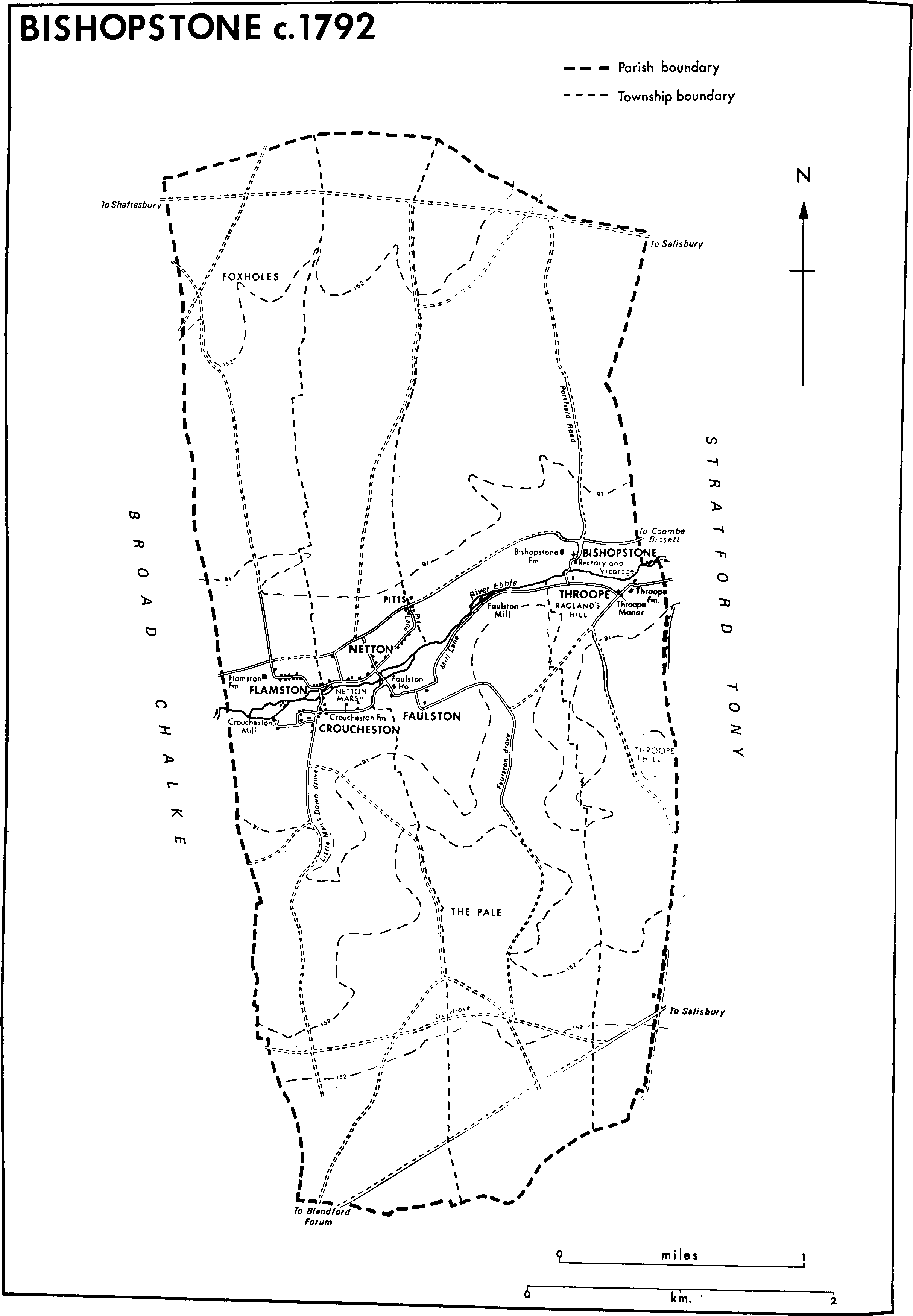
The parish of Bishopstone, 1,882 ha. (4,649 a.), is 8 km. south-west of Salisbury. (fn. 1) Measuring 6 km. by 3 km. it forms a rectangle, lies north and south across the Ebble valley between Broad Chalke to the west and Stratford Tony to the east, and is bisected by the Ebble which flows west to east across it. On the downs to the north it marches with Wilton and Burcombe Without and on those to the south with Martin (Hants). The parish contains six ancient townships, each running back from a village by the river and reaching up to the down as a long narrow strip. Bishopstone, c. 905 a., Netton, c. 555 a., and Flamston, c. 670 a., lie north of the river, Throope, c. 468 a., Faulston, c. 940 a., and Croucheston, c. 910 a., lie opposite them south of the river. (fn. 2)
Before the 10th century the land of the modern parish almost certainly, and the land to the east of it probably, were part of a single estate called Downton. (fn. 3) In the later 10th century the whole of the Ebble valley between the Chalkes and the Avon valley lands of Downton was apparently called 'Ebbesborne', and land in that region was then separated from Downton to its east and Bishopstone to its west under royal charters. (fn. 4) Bishopstone, thus physically severed from Downton, established itself as a parish between 1086 and 1208, presumably when its church was built. (fn. 5) The parish at first retained the name 'Ebbesborne'. In the early Middle Ages the epithet 'Bishop's' was often used to distinguish it from Ebbesborne Wake further up the valley, and only in the later Middle Ages did 'Bishopston' become the parish's usual name. (fn. 6)
Bishopstone's western boundary was defined in a charter of Stoke Farthing in Broad Chalke of 955, and its eastern boundary in a charter of Stratford Tony of 986. (fn. 7) Both boundaries were essentially straight and possibly approximate to those of the modern parish, except that what is north of the Roman road in the modern parish of Stratford Tony remained in Bishopstone in 986. In 997 the bounds of Bishopstone were themselves given. (fn. 8) Prominent features on them included to the south Grim's ditch, which still marked the boundary in 1976, and to the north the ridge way on the watershed of the Ebble and Nadder. Afterwards the parish gained an area of down north of that ridge way but lost the northern part of what is now Stratford Tony.
The parish is characterized by the very simple geological formation of the Ebble valley. (fn. 9) Chalk outcrops over the whole of it. Across its middle, except between Flamston and Croucheston where the stream is wide and shallow, the river has deposited a strip of alluvium, broader in the east than in the west. To the north and south of that, except where the land slopes steeply to the river between Throope and Faulston, are bands of valley gravel, much broader in the west than in the east. On the downs the chalk is overlain by deposits of clay-with-flints, in the north extensive on Bishopstone, Netton, and especially Flamston downs. In the later 17th century John Aubrey mentioned that on Flamston down there was a quarry for spar from which glass could be made. (fn. 10) The relief is sharper in the southern half of the parish. Ragland's hill and the higher ground west of it overhang the river between Throope and Faulston, and there are several steep sided coombs between Throope hill, 154 m., the summit of Faulston down, 171 m., and Croucheston down, 156 m. In the northern half the land rises steadily from river to watershed where Lyons barrow, 181 m., is on the parish boundary.
Land-use was typical of such geologically simple parishes: there was meadow land on the alluvium, arable on the valley gravel and the lower slopes of the chalk, and rough pasture on the downs. (fn. 11) Sheepand-corn husbandry prevailed in all six townships. (fn. 12) Although not extensively wooded the whole parish lay within the outer bounds of Cranborne chase, and in the 13th century suffered from the activities of the foresters. (fn. 13) The downs in the southern half were part of Vernditch chase but it is unlikely that by the later 18th century there was much woodland there. (fn. 14) From the later 18th century, and especially between 1792 and 1838, it seems that large areas of the downs in both halves of the parish were ploughed, and in the 18th and early 19th century farm buildings were erected on all the downs except that of Netton. (fn. 15) Those in the south later became the farmsteads of downland farms. (fn. 16) In the 19th century trees were planted on the clay-with-flints of the northern downs, especially at Foxholes on Flamston down and in a coomb on Netton down. (fn. 17) Bishopstone down north of the ridge way was detached from the farms of the parish and, part of the Wilton estate of the earls of Pembroke, also planted with trees. (fn. 18)
Bishopstone c. 1792
The Roman road from old Salisbury to Dorchester (Dors.) crosses the parish, making a diversion from its otherwise straight course to circumvent the coombs of Faulston and Croucheston. (fn. 19) The ridge way from Salisbury to Shaftesbury (Dors.), which crosses the downs at the north end of the parish, was the main road between those towns and was turnpiked under an Act of 1762. The turnpike trust was allowed to lapse in the 1780s, however, and the road was superseded by the newly turnpiked road along the Nadder valley. (fn. 20) The old road fell into disuse. In 1976, when it was called the old Shaftesbury drove, it remained a passable track across the parish. The main road from Salisbury to Blandford Forum (Dors.), turnpiked under an Act of 1756, (fn. 21) crosses the downs at the south end of the parish. On Throope down a ridge way called Ox drove diverges from it and leads westwards across the downs towards Shaftesbury. Between those ancient and prominent downland routes the road through Coombe Bissett and Broad Chalke, which links the Ebble valley villages from Bodenham in Downton to Alvediston, passes north of the river through Bishopstone parish where there is also a parallel road south of the river. From those roads droves lead up to the downs but only one of them, Bishopstone drove (now Portfield Road) leading northwards to Wilton, has been metalled and tarred.
Artefacts of the Mesolithic Period and later indicate prehistoric activity in the parish, but Bishopstone has not been rich in archaeological discoveries. (fn. 22) Nine bowl-barrows and slight traces of a field system on Bishopstone down have been found. (fn. 23) Their names and their sites on the valley gravel, where there were adequate water supply and drainage, indicate the probably Saxon origin of the six riverside villages of the parish. (fn. 24) The pattern of settlement changed little until the 19th century. A small community then grew beside the road from Coombe Bissett to Broad Chalke between Netton and Bishopstone and the downland farmsteads were established. The roadside settlement was called the Pitts in 1841. (fn. 25) Early-14th-century taxation assessments show the six villages to have been small but the total population of the parish, in which there were 325 poll-tax payers in 1377, was probably greater than those of most of its neighbours. (fn. 26) A similar situation is indicated by 16th-century assessments. (fn. 27) In 1801 the population was 535 and by 1831 it had reached 663. (fn. 28) By 1841 it had fallen to 569, partly because in 1838 57 people emigrated to Australia and houses were demolished. (fn. 29) Out of that total 298 lived north of the river, almost certainly more than half of them in Netton and the Pitts, 164 in Croucheston, 76 in Faulston, and 31 in Throope. (fn. 30) The population rose again to stand at 685 in 1861 but thereafter declined steadily until 1931 when it was 411. New housing built after the Second World War led to a rise in the population to 540 in 1971. (fn. 31)
The small nucleated villages of Bishopstone and Throope at the east end of the parish were different in character from the villages at the west end. Bishopstone, as its name suggests, (fn. 32) contained the bishop of Winchester's demesne farmstead, (fn. 33) and the parish church was built there. In the early Middle Ages the village seems to have contained a number of small farmsteads, presumably grouped around the church, but by at least the early 16th century they had been deserted, (fn. 34) and Bishopstone (now Manor) Farm, the church, and the rectoryhouse stood isolated from the more populous part of the parish to the west. The road leading southwards across the river from the road from Coombe Bissett to Broad Chalke ran east of the church between it and the old rectory- and vicarage-house. It was closed when the new Rectory was built in 1815 and a new road was made west of the church. (fn. 35) In 1976 the village still consisted only of Manor Farm, formerly called Bishopstone House, (fn. 36) the church, the new Rectory (then called Bishopstone House) and its lodge, a small house on the site of the old rectory- and vicarage-house, and some cottages. Manor Farm is an early-19th-century brick house surrounded by extensive 19th-century farm buildings.
Throope was the smallest of the six villages (fn. 37) and, as its name implies, (fn. 38) was isolated from the other settlements. From at least the 16th century it seems to have contained no more than a single farmstead. (fn. 39) In 1976 the farm buildings included two large barns probably of the later 18th century. Below Ragland's hill near the river a pair of cottages of 17th-century or earlier origin possibly marked the site of another farmstead. In 1927 a house called Raglands with extensive outbuildings was built on that hill. (fn. 40)
At least three of the four villages clustered at the west end of the parish were street villages. Netton street ran not quite straight from Netton marsh to Pit Lane. Farmsteads and cottages stood along it mainly on the north side. (fn. 41) The eastern end of the street has never been made up and in 1976 the eastern and western ends were no longer joined. The line of the whole street was still marked by some cottages and small farm-houses of the 17th and 18th centuries. The Three Horse Shoes was built at the western end in the 19th century. The White Hart beside the road from Coombe Bissett to Broad Chalke, at the top of the road leading from Netton marsh, was a public house in 1792, (fn. 42) but the present building is of the 19th century. In the early 19th century Netton Farm was built further along the main road near the Pitts and Netton House, later extended, near the White Hart. In 1885 the parish hall was built beside the road leading from Netton marsh and in 1921 was extended as a war memorial. In 1970 it was reopened after repairs. (fn. 43) Council houses were built to the north of it c. 1955, and in the 1960s a private housing estate was built east of Netton House between Netton street and the main road. In 1976 the Pitts was a group of 19th-century cottages south of the road with the school, some mid-20th-century council houses, and a small council housing estate of the 1970s north of the road.
Flamston street, with Flamston Farm at its west end, was a street of small farmsteads until the earlier 19th century. (fn. 44) In the earlier 20th century the street was still lined with thatched cottages (fn. 45) of which two remain. Several modern houses and bungalows have replaced the others. Flamston Farm is a 19th-century farm-house, formerly of three storeys, reduced in height and remodelled in the 1970s. East of it are extensive ranges of barns and farm buildings.
In the late 18th century Croucheston village stretched from Croucheston mill eastwards to Little Man's Down (later Croucheston) drove and along a street to Croucheston Farm. (fn. 46) There has since been little settlement in the street from which egress to the east was cut off in the mid 19th century. (fn. 47) In 1976 there were a few cottages and houses of the 17th century and later at the street's west end. At its east end Croucheston Farm, now almost square, has a north-east corner of late-17th-century origin which was part of a house largely demolished c. 1800. New ranges were then built to the west and south and the remainder of the older building was refaced. In 1976 there were two small houses probably of 17th-century origin in Croucheston drove, and west of the drove the buildings included an 18th-century farm-house with 19th-century additions, a small 17th-century house, the nonconformist chapel attached to a late-18th-century house, and a number of 19th-century cottages.
It seems likely that in the Middle Ages there was a street of tenant farmsteads east of Faulston manorhouse. The farmsteads were later abandoned and Faulston thereafter consisted of no more than the manor-house and its farm buildings until the mid 17th century. New farmsteads were then built south-east of the manor-house between Mill Lane and the north end of Faulston drove. (fn. 48) In 1976 the farm buildings beside the manor-house included a stable court of the later 19th century. The large estate farmstead south-east of the house is also of the 19th century. In 1976 no cottage at Faulston appeared older than the 19th century.
In the 19th century there were erected throughout the parish many cottages and farm buildings in the characteristic style of the Wilton estate. Many survive, and the use of alternate bands of flint and red brick for their walls is a feature of the parish. Two avenues of trees, predominantly beeches, beside Portfield Road on Bishopstone down are similarly characteristic of the Wilton estate. In the 20th century some buildings including a riding-stable and a garage have been erected beside the road from Salisbury to Blandford Forum.
Manors and Other Estates.
The land which became the parish of Bishopstone was almost certainly included in the estate called 'Downton' given to the church of Winchester as an early endowment. (fn. 49) In 902 Bishop Denewulf granted to Beornwulf 15 hides, presumably of that estate, at 'Ebbesborne'. (fn. 50) The remainder of the estate passed to King Edward the Elder in 909. In 947 King Edred granted an estate of 5 mansae at 'Ebbesborne' to Alfsige, and in 957 King Edwy granted the same land to Alfric. (fn. 51) Further grants of 5 cassati at 'Ebbesborne' were made in 956 by King Edwy to Wulfric and in 961 by King Edgar to Byrnsige, and a grant of 5 manentes in 986 by King Ethelred to Alfgar. (fn. 52) The effect of the grants of land at 'Ebbesborne' was clearly to leave the land at Bishopstone isolated from the main part of the estate at Downton, (fn. 53) and, when it was restored to the Old Minster in 997, Downton and Bishopstone were thus detached portions of the estate. (fn. 54) The creation of free tenures between 1066 and 1086 probably led to the emergence of Faulston, Flamston, Throope, and Croucheston manors in the Bishopstone portion, which in 1086 was still considered part of the bishop of Winchester's Downton estate. (fn. 55)
In the early 13th century BISHOPSTONE was itself a manor. (fn. 56) Like Downton manor it passed with the see of Winchester until 1551 when, following the deprivation of Bishop Gardiner, Bishop Ponet granted it to Edward VI. (fn. 57) The king immediately granted it to Sir William Herbert, created earl of Pembroke in that year. (fn. 58) In 1553, after the accession of Queen Mary, Pembroke was expelled by the restored Gardiner. Ponet's grant to Edward VI was cancelled under royal warrant, (fn. 59) and in 1558 the manor was regranted to Gardiner's successor White. (fn. 60) The first parliament of Elizabeth I's reign returned it to Pembroke, (fn. 61) and the manor afterwards passed with the Pembroke title. From the later Middle Ages, as at Downton, the copyholds, which were held under the manor for fixed payments, began to assume the importance of freeholds, and the descents of the principal ones, in Croucheston and Netton, are traced below. In 1947 the demesne land, Bishopstone farm, was sold with Flamston and Netton farms (see below) to Guy Temple Montacute Larnach-Nevill, marquess of Abergavenny (d. 1954). (fn. 62) In 1956 those lands were bought for Henry Edward Hugh Pelham-Clinton-Hope, duke of Newcastle, and they belonged to Newcastle Estates in 1976. (fn. 63)
The manor of FLAMSTON probably emerged from one of the estates, held of the bishop of Winchester, which became heritable between 1066 and 1086, (fn. 64) but it is not clear from which. In the 12th century Flamston belonged to members of the Flambard family and passed, presumably by inheritance, to Geoffrey de Stawell, grandson of Geoffrey Flambard. (fn. 65) In 1202 Geoffrey de Stawell defended his title against his relative Walter Flambard who apparently claimed the right of his brother Robert (d. c. 1200). (fn. 66) Geoffrey was succeeded by his son Adam to whom Walter son of Robert Flambard gave up all claim to Flamston in 1227. (fn. 67) Adam de Stawell was succeeded in 1231–2 by Sir Henry de Stawell, (fn. 68) presumably his son, who was in turn succeeded, apparently in the 1260s, by another Geoffrey de Stawell, (fn. 69) possibly his own son. In 1304 Geoffrey settled the manor on himself for life with remainder to Gunnore, widow of his son Matthew, (fn. 70) but in the same year conveyed it for life to John Uppehull, (fn. 71) possibly Gunnore's husband, who held until at least 1345. (fn. 72) After Uppehull's death the manor reverted to Sir Geoffrey de Stawell, probably the man of that name who was lord of Cothelstone (Som.) (fn. 73) and presumably the heir of Geoffrey de Stawell (fl. 1304). Sir Geoffrey (d. 1362) (fn. 74) held it in 1358. (fn. 75) He conveyed it to be held by his son William of another son Matthew. (fn. 76) In 1368 Matthew conveyed the reversion to John Lye as security for a loan, (fn. 77) and in 1374, presumably after William's death, the manor was conveyed to Lye in fee. (fn. 78)
After the death of John Lye in 1390 (fn. 79) the manor was held by his widow Agnes, apparently wife of John Pokerwell in 1395 (fn. 80) but again called Agnes Lye at her death in 1421. (fn. 81) She was succeeded by her grandson John Lye who died c. 1452 leaving as heir his son John, a minor. (fn. 82) John Lye (later Leigh) (fn. 83) entered in 1464, (fn. 84) was knighted in 1501, and held until his death c. 1523. (fn. 85) Sir John was predeceased by his son Henry and settled Flamston on Henry's daughter Mary, in 1524 the widow of William Long. (fn. 86) By 1525 Mary had married George de la Lynde, later knighted. (fn. 87) Mary died between 1545 and 1547, (fn. 88) and Sir George in 1556 when the manor passed to Edward, his son by his second wife Anne. (fn. 89) Edward died in 1556 and the manor was divided among Sir George's sisters Avice, wife of Sir Thomas Trenchard (d. 1557) and afterwards of Gilbert Wells, Warborough, wife of Thomas Morton, and Anne, wife of Robert Williams. (fn. 90) In 1565 Avice's son Henry Trenchard conveyed his third to Robert Williams. (fn. 91) Robert and Anne (both d. 1569) were succeeded by their son John (later knighted), (fn. 92) to whom Thomas Morton conveyed his third in 1576. (fn. 93) Sir John Williams (d. 1617) was succeeded by his grandson John Williams (fn. 94) whose trustees sold the manor of Flamston to William Herbert, earl of Pembroke, in 1627. (fn. 95) The manor afterwards passed with the Pembroke title until 1947 when Flamston farm was sold with Bishopstone farm. (fn. 96) The Lyes had a manor-house at Flamston but nothing is known of its size and architectural style. (fn. 97)
Between 1066 and 1086 14 hides of the bishop of Winchester's estate, including the later manor of FAULSTON, were acquired by William de Braose (later Brewes), lord of Bramber (Suss.). (fn. 98) The overlordship of Faulston, held of the bishops, (fn. 99) passed with the barony of Bramber to William's son Philip (d. between 1134 and 1155), grandson William (d. c. 1192), and great-grandson William (d. 1211) whose lands were confiscated in 1208. The lands were restored to that William's younger son Reynold in 1216 but c. 1220 passed to John de Brewes, son of William's son William (d. 1210). (fn. 100) John (d. 1232) was succeeded by his son William (d. 1290–1) and grandson William de Brewes (d. 1326), Lord Brewes, whose daughter Aline (d. 1331), wife of John de Mowbray (d. 1322), Lord Mowbray, succeeded to the barony of Bramber. (fn. 101) Aline's son John, Lord Mowbray (d. 1361), was said to be overlord of Faulston in the year of his death. (fn. 102) He was succeeded by his son John, Lord Mowbray (d. 1368), and grandson John de Mowbray, earl of Nottingham (d. unmarried 1382–3), (fn. 103) but nothing further is heard of the Mowbrays as overlords, and in 1412 the heir of their tenants was said to hold Faulston immediately of the bishop of Winchester. (fn. 104)
The manor of Faulston was held in the early 13th century by Ralph le Tablier (fn. 105) who was succeeded in 1238 by his son Thomas, (fn. 106) knighted before 1249. (fn. 107) In the 1280s a Thomas le Tablier, perhaps Sir Thomas's son, held the manor (fn. 108) which passed to Guy le Tablier, possibly Thomas's son. (fn. 109) Guy's heir was his daughter Edith, wife of Richard of Grimstead. (fn. 110) In 1289 the manor was in the hands of trustees, (fn. 111) but in 1309 was settled on Richard and Edith. (fn. 112) Their heir was their son Thomas (d. 1328) whose son Thomas died a minor in 1328 leaving as coheirs his father's sisters Margaret, wife of Thomas Benton, and Catherine, wife of Ralph Buckland. (fn. 113) Faulston was allotted to Margaret (d. 1340) and Thomas (d. 1358) except for the third assigned in dower to the elder Thomas Grimstead's widow Joan (d. 1361). (fn. 114)
The Bentons, whose family name came to be rendered Baynton, were succeeded by their son Nicholas (d. 1412) (fn. 115) and grandson Sir Nicholas Baynton (d. 1422) (fn. 116) whose widow Joan held until 1429. She then conveyed Faulston to her son Sir John Baynton on her marriage with William Whaplode. (fn. 117) Sir John died in 1465 leaving a widow Catherine who held until her death in 1473. (fn. 118) In 1475 their son Sir Robert was attainted for having supported Henry VI at the battle of Tewkesbury in 1471 (fn. 119) and the manor was granted to John Cheyne. (fn. 120) In 1484 Cheyne was himself attainted following Buckingham's rebellion against Richard III (fn. 121) who in 1485 granted Faulston to George Nevill. (fn. 122) After the battle of Bosworth the manor was restored to Cheyne (knighted 1485, created Lord Cheyne 1487, d.s.p. 1499). (fn. 123) It apparently passed to Anne, daughter and heir of Sir Edward Trussel and a minor in 1500, (fn. 124) but in 1503 the attainder of Sir Robert Baynton was reversed and Faulston restored to his son John. (fn. 125) In 1516 John Baynton was succeeded by his son Sir Edward (fn. 126) and the manor was settled for their lives on Sir Edward and his second wife Isabel. (fn. 127) Sir Edward died in 1545 (fn. 128) and Isabel, afterwards wife of Sir James Stumpe (d. 1563) and Thomas Stafford, (fn. 129) held until her death in 1573, when she was succeeded by her son Henry Baynton. (fn. 130) Before Isabel's death an interest in the manor had apparently been conveyed to Anthony White and his wife Mary, (fn. 131) but in 1577 Charles Vaughan bought out the interests of both Henry Baynton and the Whites. (fn. 132)
Vaughan (d. 1597) was succeeded by his grandnephew Walter Vaughan (knighted 1603). (fn. 133) After Sir Walter's death in 1639 the manor passed to Dorothy, widow of his eldest son Sir Charles, and afterwards to his son George (knighted 1643). (fn. 134) Sir George, an active supporter of Charles I, was wounded at the battle of Lansdowne in 1643 but fought again in 1644 and 1645. (fn. 135) In 1645 Faulston House and the manor were occupied by the parliamentary committee for Wiltshire. (fn. 136) In 1649 Vaughan sold the manor to Philip, earl of Pembroke and Montgomery (d. 1650). (fn. 137) It passed with the Pembroke title until in 1919 Faulston farm was sold to the tenant W. H. Brown. (fn. 138) In 1932 Brown sold to George Watkinson (d. 1972) whose daughter Miss M. Freya Watkinson owned the land in 1976. (fn. 139)
Faulston was the home of the Bayntons probably from the earlier 14th century to the early 16th. (fn. 140) Traces of a moat can be seen on the north, east, and south sides of the present house, and in the southeast angle of the enclosure there is a tall circular tower with evidence of high abutting walls on two sides. (fn. 141) The tower, which is of alternate bands of stone and faced flint, may date from the licence to crenellate granted to Nicholas Baynton in 1376, (fn. 142) but its only architectural feature is a late-medieval doorway to the southern wall-walk. The house may have lain within the walled enclosure or have formed one side of it with a walled court to the south. It passed with the manor and was occupied by the Vaughans. (fn. 143) It was 'slighted' in 1645. (fn. 144) Aubrey described Faulston House as 'noble old-fashioned'. He mentioned its moat, embattled walls, and two south-facing towers. (fn. 145) A short stretch of walling forming part of the south-west corner of the present house is of similar character to the tower, and the main east wall of the house has in it four doorways of late-15th- or 16th-century character which suggest that it may have been part of a screens passage or entrance hall. The double pile plan of the house, however, dates from a mid-17th-century reconstruction, presumably after the manor changed hands in 1649, and there are mullioned windows of that period in the north and west walls. The house was remodelled in the early 19th century when the south entrance front was refenestrated and the present staircase was inserted, and again later in that century when the kitchen was partly rebuilt, and perhaps reduced in size, and the interior was refitted.
In the early 13th century land in the parish, later called the manor of THROOPE, was held with land in Kilmeston (Hants) by William Gimmings. Before 1224 William's brother Thomas succeeded him although his widow Alice, wife of John de la Bere, held a third in dower. (fn. 146) Before 1250 Thomas gave the land in exchange for land in Farlington (Hants) to Roger de Merlay on the marriage of his son Nicholas to Roger's daughter Agnes, but later the exchange seems to have been reversed. (fn. 147) Thomas held until at least 1275. (fn. 148) Nicholas (d. 1282) left as heir a son John (fn. 149) who held in 1290. (fn. 150) It is not clear how the Gimmingses' land descended in the 14th century. In 1307 John's land in Kilmeston was alienated in mortmain, (fn. 151) but that at Throope possibly passed like Chessell manor in Shalfleet(I.W.) to Nicholas Gimmings (d. 1349) and John de Lisle (d. 1349). (fn. 152) John de Lisle's widow Joan possibly married Geoffrey Rookley, lord of the manor of Arreton (I.W.). (fn. 153) In 1417 John Rookley, perhaps their son, granted the Throope land to Dominic Uppehull and his wife Alice for their lives with successive remainders to William and Lewis Meux, sons of Richard Meux. (fn. 154)
In 1428 Lewis Meux held the land. (fn. 155) He was succeeded by his son Thomas (d. before 1472), grandson Sir William Meux (fl. 1507), and greatgrandson John Meux (d.s.p. 1568) whose heir was apparently his grand-nephew John Meux (knighted 1605, d. 1629). (fn. 156) Sir John married Cecily, daughter of William Button of Alton Priors in Overton, a relative of whom seems to have farmed the land in the early 17th century. (fn. 157) He was succeeded by his son Sir John (d. 1657) and grandson Sir William Meux (d. 1697) (fn. 158) who held in 1670. (fn. 159) The elder Sir John's granddaughter Eleanor Compton (d.s.p. c. 1707) married Sir Robert Button (d. 1678). (fn. 160) In a way that is not clear Throope passed from the Meuxes to Buttons, but apparently to a member of that branch of the Button family which had been farming it since the early 17th century. (fn. 161) It was held by John Button (d. 1730) who was succeeded by his sons John(d. 1738) and George (d. 1763). (fn. 162) George's heir was his sister Mary (d. 1768), wife of Henry Rooke (d. c. 1794) of Breamore (Hants). Throope passed to Mary's son John Rooke who was succeeded c. 1812 by his nephew Henry Rooke (d. 1850). Henry left as heir his daughter Maria, wife of Walter Young (d. 1894). (fn. 163) In 1899 the land was sold by Young's trustees to the Wilton estate. (fn. 164) In 1919 Throope farm was sold to Josiah Antell (fn. 165) whose sons Percy and Thomas sold it c. 1930 to Lt.-Cdr. L. C. Ansdell. In 1933 it was sold to Algernon George de Vere Capell, earl of Essex, and in 1955 to Antony Henry Head, Viscount Head, the owner in 1976. (fn. 166)
The main east front of Throope Manor is of five bays. It was arranged symmetrically in the mid or later 18th century, but in its two southern bays incorporates the end of an earlier range which was probably built in the 17th century. Inside is much reset early-17th-century panelling. The 18th-century house, which was almost square, was greatly enlarged to the south and west in the 1930s by Lord Essex. (fn. 167)
Land in Throope was held freely by John Martin (d. 1461) of Gillingham (Dors.). He is said to have granted it in 1458–9 for the saying of a mass in St. James's aisle in Gillingham parish church. (fn. 168) The land was held by the Fraternity of Jesus in Gillingham until the dissolution of the chantries. (fn. 169) In 1557 it was granted by the Crown to John Eliott and Alexander Chesenall. (fn. 170) They immediately conveyed it to Thomas St. Barbe who sold it to John Newman. In 1566–7 Newman's title was challenged by Christopher Withers and his wife Joan, a descendant of John Martin. (fn. 171) The descent of the land thereafter is not clear. Newman's title was apparently proved (fn. 172) but later the land was merged with Throope manor. (fn. 173)
Holdings in Throope were parts of both Bishopstone and Faulston manors. A substantial holding was part of Faulston manor in 1328. (fn. 174) It passed with the manor to the earls of Pembroke and Montgomery. (fn. 175) From the mid 17th century to the 19th members of the Button and Rooke families held it by copies, (fn. 176) and the land was merged with Throope farm when it was bought by the Wilton estate in 1899. (fn. 177) The holding attached to Bishopstone manor was similarly held from the early 18th century by different members of the Button and Rooke families and was also merged with Throope farm. (fn. 178)
In the early 13th century William Daundely held an estate of the bishop of Winchester in the parish. (fn. 179) It later passed to Walter Daundely, lord of the manor of Chilton Candover (Hants), (fn. 180) and in 1275 was held by Robert Daundely. (fn. 181) The Daundelys' estate, of which nothing further is heard, cannot be identified with certainty, but was possibly the overlordship of land in Croucheston which passed in the Bramshott family. The Daundelys' heirs were the Bayntons and in the 17th century and later Croucheston manor was said to be held of Faulston manor. (fn. 182)
In 1227 William de Lusteshull quitclaimed land to William Bramshott. (fn. 183) The land seems to have passed like the manor of Bramshott (Hants) through the Bramshott family. (fn. 184) A William Bramshott held it in the early 14th century, (fn. 185) and in 1406 William Bramshott (d. between 1432 and 1444) held it. (fn. 186) That last William's heir was his son John (d. 1468) who in 1455 made a settlement of the land, then called CROUCHESTON manor. (fn. 187) John's heirs were his daughters Elizabeth, wife of John Dudley, and Margaret, wife of Sir John Pakenham, (fn. 188) but it is not clear how Croucheston descended until in 1516 it was conveyed by trustees to Ivychurch Priory. (fn. 189) The priory retained it until the Dissolution when it passed to the Crown. (fn. 190)
The manor was granted to Ellis Wynne in 1563 (fn. 191) and was apparently sold by him soon afterwards. It possibly belonged to Edward Hayward in 1576 (fn. 192) and it descended through the Hayward family. Another Edward Hayward probably held it c. 1628. (fn. 193) He was succeeded by his son Edward and grandson George Hayward who in 1678 sold the manor to Richard Kitson. (fn. 194) In 1691 Kitson sold it to John Ballard, a doctor of medicine, who was succeeded by his son the Revd. John Ballard, and grandson John Ballard, a Fellow of Winchester College. (fn. 195) In 1767 that last John sold the manor to Edward Hewett (d. 1796) who devised it to his nephew John Hewett (d. 1805). (fn. 196) About 1816 John Hewett's widow Sarah, then Sarah Chamberlain, sold it to James Swayne (d. 1866). (fn. 197) About 1885 the land was acquired by the Wilton estate from James's son Henry, apparently by exchange, and was added to Croucheston farm (see below). (fn. 198)
In 1189 Waverley Abbey was confirmed in an estate in Croucheston which had possibly been an early grant by the abbey's founder William Giffard (d. 1129), bishop of Winchester, or his successor Bishop Blois. (fn. 199) The land remained with the abbey until it passed to the Crown at the Dissolution. (fn. 200) In 1536 it was granted to Sir William Fitzwilliam (fn. 201) and in 1538 apparently conveyed to Thomas Chaffin (will proved 1559) of Salisbury, whose son Thomas died holding it in 1619. (fn. 202) The younger Thomas left a son Thomas and grandson Thomas Chaffin, one of whom sold the land to Edward Hewett (will dated 1662). (fn. 203) Hewett devised it to his son Nicholas, and it passed to Nicholas's son Nicholas and grandson Richard Panton Hewett who in 1728 sold to the Revd. John Ballard. (fn. 204) The estate afterwards passed with the manor of Croucheston. (fn. 205)
A substantial holding in Croucheston was part of Faulston manor in 1328. (fn. 206) It passed with the manor to the earls of Pembroke and Montgomery, (fn. 207) and in the 19th century was the basis of Croucheston farm to which Croucheston manor (see above) and Alfred Morrison's land (see below) were added. (fn. 208) In 1919 the farm was sold to C. M. Wort and it later passed to his son George and grandson Mr. J. H. Wort who owned it in 1976. (fn. 209)
A substantial copyhold of inheritance in Croucheston, held of Bishopstone manor, was entered in 1543 by Hugh King who held it until at least 1576. (fn. 210) John King entered it in 1610 and held it until at least 1632. (fn. 211) In 1672 Edward King held it and in 1729 Edward King, presumably another, was succeeded by his brother John (d. c. 1746), whose heir was another brother Thomas. In 1746 Thomas settled the land on himself for life with remainder to William Clarke, and in 1750 Clarke died holding it. His heir was his brother John (d. 1764) who was succeeded by his son William, a minor, admitted in 1778. William (d. 1792) was succeeded by his brother Edward (d. 1795) whose widow Elizabeth, wife of Thomas Harding, held the land until 1821 when Maria, daughter of Edward Clarke and wife of Joseph Nowlson, was admitted. In 1824 the Nowlsons sold it to Elizabeth Snook (d. 1845). (fn. 212) She devised the land to trustees to pay certain annuities and afterwards to the children of Ann, wife of John Stevens. (fn. 213) In 1881 the children, John Henry Stevens, Anna Maria Stevens, and William Snook Stevens (d. 1883) were admitted. (fn. 214) The land, which was the only substantial estate in the parish never part of the Wilton estate, was enfranchised in 1895. (fn. 215) In 1933 it belonged to John Stevens, (fn. 216) and in 1976 partly to Mr. J. H. Wort and partly to Mr. Richard Lamb. (fn. 217)
Another substantial copyhold of inheritance in Croucheston was entered by John Gyett in 1514–15, and a John Gyett held until at least 1576. (fn. 218) In 1605 Thomas Hewett entered it. He held it until at least 1632, (fn. 219) and afterwards the land descended in the Hewett family. In 1709 Thomas, son of another Thomas Hewett, was admitted. (fn. 220) His widow Tabitha held the land from Thomas's death in 1739 until her own in 1777 when she was succeeded by her grandson Thomas Hewett (d. 1805). That Thomas's widow Sarah held it until her death in 1829 and was succeeded by her son John Hewett, who in 1840 sold it to James Swayne. (fn. 221) The land passed with Swayne's manor of Croucheston until 1860 when the copyhold of inheritance was sold to Alfred Morrison of Fonthill House in Fonthill Gifford. (fn. 222) About 1890 the land passed, presumably by sale, to the Wilton estate and became part of Croucheston farm (see above). (fn. 223)
A substantial copyhold of inheritance in Netton, held of Bishopstone manor, was entered in 1530–1 by Christopher Whitmarsh who held it until at least 1567. (fn. 224) In 1576 William Whitmarsh probably held it. (fn. 225) Jasper Shergall entered it in 1615 and held it until at least 1632. (fn. 226) The land passed to his son John whose daughter and heir Hannah married William Whitehart. (fn. 227) In 1718 Whitehart died holding the land which passed to his son William and grandson William Whitehart, who in 1773 sold it to Thomas Bevis (d. 1778). Bevis's widow Anne held it until her death in 1803 when it passed to Sarah, niece of Thomas Bevis and wife of James Wilton. At Sarah's death in 1826 Thomas Browning was admitted under Thomas Bevis's will. In 1827 he sold the land to William Rowden (d. 1855). (fn. 228) After his death Rowden's land was held by his trustees until 1865, when they sold it to George, earl of Pembroke and Montgomery. (fn. 229) It was added to Flamston farm and passed with the manor of Bishopstone. (fn. 230) A small manor-house called Netton Old Farmhouse in 1947 passed with the estate. It is a symmetrical house dated 1637 with walls of chequered stone and flint rising two full storeys with attics and with a thatched roof.
Another substantial copyhold of inheritance in Netton was entered by Giles King in 1558. (fn. 231) Another Giles King entered it in 1614 and held it until at least 1632. (fn. 232) The land passed to his son Giles (d. 1711) and great-grandson Giles King who in 1723 sold it to John Barber. In 1731 Barber was succeeded by his son John who in 1777 sold the land to John Baker (d. 1789). In 1795 Baker's executors sold it to John Johnson (d. 1799), who was succeeded by his son John (d. 1807) and grandson William Johnson. In 1810 William sold the estate to Christopher Crouch who in 1825 sold it to Elizabeth Snook. (fn. 233) The land thereafter passed with Elizabeth's land in Croucheston (fn. 234) until the Stevenses sold it to Alfred Morrison in 1882. (fn. 235) In 1885 it passed, apparently by exchange, to the Wilton estate and was added to Netton farm (see below). (fn. 236)
A copyhold of inheritance of some 50 a. in Netton had been acquired by an earl of Pembroke and Montgomery by 1792. (fn. 237) Another of similar size was bought in 1855 (fn. 238) and a third of similar size was also bought. (fn. 239) Those three holdings formed the basis of Netton farm to which Morrison's land (see above) was added. Netton farm passed with the manor of Bishopstone. (fn. 240)
Economic History.
In 997 Bishopstone accounted for 45 of the 100 mansae of the bishop of Winchester's Downton estate. In Domesday Book it was included in the assessment of Downton. (fn. 241) The bishops' manor of Bishopstone, of which the other manors in the parish were held, (fn. 242) and which included customary tenants in Bishopstone, Netton, and Croucheston but demesne land in apparently no other part of the parish but Bishopstone tithing, (fn. 243) was at farm in the period 1208–11 but in hand from 1211. (fn. 244)
The land of Bishopstone tithing, including Netton, was shared in the Middle Ages by the bishop in demesne and by his customary tenants of Bishopstone and Netton. The arable was cultivated as two fields, as three from c. 1300. (fn. 245) The amount sown for the bishop was usually above 250 a. until c. 1280, declined gradually c. 1280–1350, and from 1350 to 1450 averaged c. 150 a. The number of sheep kept for him varied considerably in the 13th century and on only a few occasions exceeded 600. In the 14th century his sheep farming increased in importance, and in the earlier 15th century the sheep in his flock consistently numbered over 800. (fn. 246) If used, tenants' labour services were probably sufficient for most demesne husbandry. (fn. 247) In the early 13th century the bishop apparently had nine 2—virgaters at Netton and eighteen ½—virgaters at Bishopstone. (fn. 248) In 1456 the demesne land, but not the sheep and pasture for 600 wethers, was leased; (fn. 249) in 1475 the sheep pasture was leased with the land; (fn. 250) and in 1532 the whole manor other than the rights of lordship was leased. (fn. 251) On one of those occasions, possibly in 1456, the lands of the eighteen ½-virgaters in Bishopstone were added to the demesne lands which were separated from the lands of the customary tenants of Netton, concentrated in Middle and East fields in the east part of the tithing, and inclosed.
In 1567 the demesne farm, later called Bishopstone farm, included some 800 a. (fn. 252) Leases of the land and fixed rents of the customary tenants of Netton and Croucheston were held for lives at a fixed rent, but were paid for by large fines. (fn. 253) They passed from Thomas ApRice, lessee in 1532, (fn. 254) to his relative George Penruddock (knighted 1568) of Compton Chamberlayne, (fn. 255) to Penruddock's relative Thomas Smith, and to Smith's son Thomas (will proved 1647). (fn. 256) Members of the Trotman family and their trustees held from 1648 to 1786 when Henry, earl of Pembroke and Montgomery, took the estate in hand. (fn. 257) Bishopstone farm, 892 a. in 1838 but later reduced to 845 a. south of the old Shaftesbury drove, (fn. 258) was afterwards let at rack-rent. (fn. 259) Farm buildings were erected on the down, and presumably much of the pasture there ploughed, between 1792 and 1838. (fn. 260) In 1976 the farm, then called Manor farm, was worked primarily from Bishopstone and devoted to mixed farming.
The nine 2-virgaters apparently in Netton in the early 13th century held virgates nominally of 16 a. (fn. 261) After the lands of Netton and Bishopstone were separated, the customary tenants of Netton cultivated the lands of their township alone and in common. In 1567 the 18 yardlands were shared among eight copyholders whose rents and fines were fixed, but a few of whose formerly onerous labour services were still recorded. (fn. 262) In 1632 there were ten copyholders with holdings varying from those of Jasper Shergall, whose 4 yardlands consisted of 70 a. and feeding for 168 sheep and 14 beasts, and Giles King, 3 yardlands with 55 a. and feeding for 126 sheep and 10 beasts, to two of fewer than 15 a. The arable land of Netton, presumably the former West field of Bishopstone tithing, was cultivated in three fields, some 275 a. north of the road from Coombe Bissett to Broad Chalke. (fn. 263) North of it there were downs, probably totalling some 220 a., (fn. 264) with pasture for cattle and 736 sheep, (fn. 265) abated to c. 700 in 1667. (fn. 266) Some 52 a. of inclosed lands lay in small closes of meadow between Netton street and the river, and in long narrow closes of arable between the farmsteads on the north side of the street and the road from Coombe Bissett to Broad Chalke. (fn. 267)
About 1750 there were roughly the same number of farms as in 1632, and indeed as there had been since the Middle Ages, (fn. 268) but in 1792, when the common fields and downs were inclosed, there were half as many. (fn. 269) After inclosure Thomas Bevis's farm measured 213 a., John Baker's executors' 157 a., and there were three farms of c. 50 a. (fn. 270) Netton marsh, 6 a., remained a common feeding- and watering-place and in 1838 was deemed parochial land. (fn. 271) In 1827 Bevis's farm, the westernmost strip of Netton land, was acquired by the tenant of Flamston farm which adjoined it. (fn. 272) The land has since remained part of Flamston farm although the buildings in Netton street were not given up until 1947. (fn. 273) In the later 19th century the three farms of c. 50 a. were amalgamated to form Netton farm, to which the farm formerly Baker's, with its extensive early-19th-century buildings beside the road from Coombe Bissett to Broad Chalke, was added in 1885. Netton farm then measured 295 a. (fn. 274) It was halved c. 1914 and the eastern half afterwards merged with Bishopstone farm. (fn. 275) In 1976 Netton remained a mixed farm sandwiched between Bishopstone and Flamston farms. (fn. 276)
From the mid 13th century to the mid 14th part of Flamston manor was possibly held by lease. (fn. 277) In 1358, presumably on entering the manor, (fn. 278) Sir Geoffrey de Stawell regranted several smallholdings, some formerly held in bondage, freely for lives, (fn. 279) and there were then other smallholdings in Flamston township held freely. (fn. 280) The demesne was possibly in hand in the later 14th century, when the demesne and tenantry arable lands were intermingled in two common fields, (fn. 281) and in the early 15th century, but in 1413 Agnes Lye leased it to her son Nicholas and, with all the buildings except the living accommodation in the manor-house, it was leased again in 1432. (fn. 282) For most of the 16th century members of the Atwater family were lessees. (fn. 283)
In 1632 the township contained some 60 a. of inclosed lands, 420 a. of arable then in three common fields, and common pasture for some 1,000 sheep and 160 other animals. The lands were reckoned 20 yardlands and were shared among the demesne farm and two smaller holdings, presumably former copyholds, all held by lease, eight copyholds, and the glebe farm. (fn. 284) The accounting of the demesne at 9 yardlands, the glebe at 1, and the small leaseholds and copyholds at a total of 10 possibly reflected an early and equal division of the township between demesne, from which the glebe was later taken, and tenantry land, and was an accurate measure of the division in 1632. The inclosed lands included, in the south-west corner of the township, 22 a. of demesne arable south of the road from Coombe Bissett to Broad Chalke and 15 a. of arable in crofts north of the road held by the other tenants. (fn. 285)
The number of farms seems to have changed little before the later 18th century. (fn. 286) In 1771 the demesne, which from 1622 or earlier had been leased for years on lives and sub-let, was let at rackrent by Henry, earl of Pembroke and Montgomery. (fn. 287) Between then and 1792 several of the smaller holdings were added to it. (fn. 288) The common lands were inclosed in 1792. The western and northern parts of the arable land and the whole of the down were allotted to the demesne farm which then measured c. 550 a., had buildings at the west end of Flamston street, and was later called Flamston farm. There remained five small copyholds, none above 25 a., with land in the south-east corner of the township near their farmsteads along the street. The church's land in Flamston was exchanged for land in Faulston. (fn. 289) By 1838 Flamston farm had absorbed virtually the whole township. Much of the down had presumably been ploughed, and new buildings had been erected on the southern edge of the down and further north beside an extensive new covert at Foxholes. (fn. 290) From 1827 some 213 a. of Netton were held with the farm, (fn. 291) which measured 875 a. in 1883. (fn. 292) Edwin Dibben, then the tenant, was a noted breeder of Hampshire Down sheep. (fn. 293) By 1947 the downland north of the old Shaftesbury drove and the meadow land south of the farmstead had been detached from the farm, 774 a. The buildings at Foxholes were then used as a piggery. (fn. 294) In 1976 Flamston remained a large mixed farm.
In the Middle Ages the lands of Croucheston township were cultivated in common (fn. 295) and shared among the bishop of Winchester's customary tenants, Waverley Abbey, and the holders of Croucheston and Faulston manors. Waverley Abbey's land, which in the late 13th century was held by a tenant for 20s. a year, was assessed at 1 hide, (fn. 296) Croucheston manor at 3 hides. (fn. 297) In the earlier 13th century the bishop's land was reckoned 17 virgates, 12 held each for 4s. a year and numerous labour services and 5 for 10s. a year each without labour service. The 5 virgates had all been held by Nicholas of Coombe, and their terms of tenure were possibly the result of a commutation arranged between Nicholas and a bishop. (fn. 298) In 1328 the lord of Faulston held in Croucheston more than half of an estate consisting of 1 carucate of land, 4 a. of meadow, and 56s. a year rent. (fn. 299)
In the mid 16th century the arable land of the township was cultivated in three common fields, East, West, and to the north of them Middle, in all some 450 a., and there were separate downs for sheep and cattle, some 400 a., of which Cow down was the southernmost. (fn. 300) In the mid 17th century there were some eight farms. The largest, 130 a. with feeding for 260 sheep and 26 beasts, was that of Faulston manor, which from 1667 or earlier earls of Pembroke and Montgomery leased for years on lives for heavy fines. (fn. 301) Croucheston manor consisted of 120 a. and feeding rights. (fn. 302) The lands formerly of Waverley Abbey apparently consisted of no more than 20 a. with feeding for 40 sheep and 3 beasts, and was later added to Croucheston manor. (fn. 303) There were five copyhold of inheritance tenants of Bishopstone manor in Croucheston. In all they held some 180 a. and disproportionately large stints of 600 sheep and 31 beasts. (fn. 304)
The common fields and downs were inclosed in 1792. After inclosure there were four farms of more than 100 a., three of fewer than 100 a. The larger farms were allotted lands in long narrow strips running back to the downs from the farmsteads in Croucheston street. (fn. 305) The easternmost, Faulston manor land, 221 a., became the base for Croucheston farm. It was let at rack-rent from 1811. (fn. 306) In 1838 its tenant James Swayne owned the next farm to the west, Croucheston manor, then 245 a., and in 1840 bought John Hewett's, the next farm to the west of that, 140 a. (fn. 307) Elizabeth Snook's farm, 171 a., lay along the western boundary of the parish. (fn. 308) Although not in single ownership until c. 1890, (fn. 309) Croucheston farm apparently remained intact. In 1919, when there were probably other farms of 171 a. and 93 a. in the township, (fn. 310) Croucheston was a mixed farm of 632 a. with buildings in Croucheston and on the down. (fn. 311) Croucheston Down farm was afterwards detached from it, but other land was added and in 1976 Croucheston was still a large mixed farm worked from Croucheston street. Croucheston Down remained a separate mainly arable farm. (fn. 312)
The land in Faulston was all part of Faulston manor. In 1328 the demesne land of the manor was said to be 250 a. of arable, 6 a. of meadow, and a pasture called Ox down; and near the manor-house were a sheepfold and a rabbit warren. In 1340 there were said to be only 160 a. of arable. In 1328 there were five bond tenants and eleven cottars, in 1340 five bond tenants and three cottars. In the township's open field demesne and tenantry strips were apparently intermingled, and the upland pastures were used in common. (fn. 313) In 1387 the bondmen and bond tenants rebelled against their lord Nicholas Baynton by withdrawing their customary services and, it seems, by resisting attempts to enforce them. (fn. 314) The cause of the rebellion, which a commission of oyer and terminer was issued to suppress, is nowhere recited but possibly lay in a desire of Baynton, who by then may have rebuilt and fortified the manorhouse, (fn. 315) to inclose the flat summit of Faulston down, later called the Pale. That inclosure was effective in 1618, when the Pale was marked on a map as a park, (fn. 316) and the late 14th century seems the most likely date for it. Later, probably in the 15th century as at Bishopstone, (fn. 317) the customary holdings were given up and merged in the demesne as a single farm, which in the late 15th century and the 16th members of the Aynoll family apparently held. (fn. 318) In 1647 the Faulston House committee leased it for £170. (fn. 319)
After Philip, earl of Pembroke and Montgomery, acquired the manor, the farm was divided into an inclosed home farm, Faulston, and the remaining lands of the township, the 'outlands' around the east and south sides of the farm. (fn. 320) Faulston farm was held by leases for years on lives under heavy fines until 1809. (fn. 321) It consisted of some 288 a. including 112 a. of arable land and the Pale, 80 a. of rough grazing in which the earls of Pembroke and Montgomery reserved feeding for deer. The rent included twelve trout for the fishing but the tenant was entitled to the second best acre of underwood cut each year at Vernditch in Broad Chalke. (fn. 322) The 'outland', none of it held customarily, was divided equally into six. New farmsteads were built on 6 a. of dry meadow taken from Faulston farm between Faulston drove and Mill Lane and in 1650–1 the six farms were leased, two together and four separately, for years on lives under fines totalling £2,200. Common husbandry was practised in two meadows each of 6 a., three arable fields and a close totalling some 180 a., and the down, 426 a., on which 840 sheep could be kept. That 'outdown' was also open to the lord's deer. (fn. 323) From 1767 the tenures on lives began to be eliminated. (fn. 324) The 'outlands' were inclosed in 1792. (fn. 325) Four of the farms, in single occupancy at rack-rent, were allotted some 410 a.; the remaining two farms, also in single occupancy, were allotted some 178 a.; the rector and vicar was allotted 29 a. to replace his lands in Flamston. In 1803 the 'outlands' were united as a single farm, and the common feeding of 13 a. of the steeper slopes of the down perpetuated by the inclosure award was thus eliminated. (fn. 326)
In 1838 the township contained Faulston farm, 301 a. with buildings on the opposite side of the road to the west side of the manor-house, and the 'outland' farm, 610 a. with buildings on the site of the six farmsteads but also with buildings and presumably ploughed land on the down. (fn. 327) Apart from 210 a., which in the later 19th century were leased to Edwin Dibben, tenant of Flamston farm, the two farms were later merged as Faulston farm. (fn. 328) In the 19th century extensive new buildings were erected for it on the site of the six farmsteads. In 1919 Faulston farm measured 707 a. (fn. 329) The remaining land in the township, some 200 a. in the north-east corner, was part of Throope farm and remained so in 1976. (fn. 330) In 1932 Faulston Down farm was detached, and in 1976 Faulston farm was an arable and beef farm of 480 a. Faulston Down remained a separate farm. (fn. 331)
In the Middle Ages the lands of Throope were used in common by the holders of Throope manor and the estate which passed to the Fraternity of Jesus in Gillingham, and by the tenants of Faulston and Bishopstone manors who held land in Throope. Throope manor consisted of a demesne farm reckoned 1 carucate and, in the early 15th century, of five small tenant holdings totalling some 35 a. (fn. 332) Tenants were not subsequently mentioned, and in the 16th century all the lands of the manor were apparently leased to members of the Ragland family. (fn. 333) The fraternity's lands, leased for 50s. a year in the mid 16th century, were presumably not extensive. (fn. 334) The copyholds in Throope which were part of Faulston manor were moderately sized, (fn. 335) but the copyholder of Bishopstone manor who held there had a cottage and only some 6–8 a. (fn. 336)
In the 17th century the arable, some 300 a., was cultivated in three common fields and there was a down for sheep and feeding in common for cattle. (fn. 337) From 1702 the copyhold of inheritance land of Bishopstone manor in Throope passed with Throope manor as Throope farm, with which the land of the Fraternity of Jesus had probably been merged. (fn. 338) From 1708 the three copyholds of Faulston manor, together amounting to 88 a. and feeding for 200 sheep and 14 other animals, were held by members of the Button and Rooke families, but not by those who owned Throope farm. (fn. 339) It is likely, however, that the whole of Throope was worked as a single farm from 1708, and that cultivation in common was thus effectively eliminated. (fn. 340) To resolve uncertainties about which lands belonged to Throope farm, and which to Faulston manor, an award was made in 1762 under an agreement of 1758 to separate the lands. (fn. 341) The eastern side of the arable land and the whole of the down were allotted as the freehold and copyhold of inheritance land of Throope farm, 351 a., which was inclosed. (fn. 342) Barns had been erected on the down, much of which had presumably been ploughed, by 1773. (fn. 343) The western side of the arable land was allotted to the three copyholds for lives of Faulston manor, 115 a., which theoretically remained under common cultivation until at inclosure in 1792 allotments were made in respect of each copyhold. (fn. 344) All remained part of Throope farm, 468 a. in 1838, (fn. 345) although held by the owner of that farm from only 1850. (fn. 346)
In the later 19th century a separate sheep-andcorn farm of 152 a., Throope Down farm, was established on the down and centred on the old barns near the road from Salisbury to Blandford Forum. (fn. 347) It had been reunited with Throope farm by 1919 and some 200 a. of Faulston added to make Throope farm then 689 a. (fn. 348) Throope Down farm was again separate in 1939, (fn. 349) but in 1976 its land was worked from outside the parish and its buildings, apart from a 20th-century house, had been taken down. Throope farm, which was worked with land in Stratford Tony, was in 1976 devoted mainly to arable and beef production. (fn. 350) The buildings at Raglands were used before the Second World War for dog-breeding, (fn. 351) and after that war for the breeding of turkeys and silver foxes. Turkey farming increased in the 1950s but ceased c. 1960. (fn. 352)
In 1890 Netton marsh, (fn. 353) through which the Ebble flowed as a broad and shallow stream, was used by Isaac Barter to make a watercress bed of c. 1 a. south of Netton street. (fn. 354) By the mid 20th century a new bed had been built on the opposite side of the Netton-Croucheston lane. After the Second World War the first bed was enlarged to the east, a small new bed was made near the site of Croucheston mill, and a large bed was made on a meadow south of Flamston Farm. (fn. 355) That last bed was given up c. 1960 and later converted into a pond for trout farming. The cress beds, which have remained in the Barter family, are fed with pure water springing from artesian wells at a constant 51°F. The cress, cut and packed at Netton, has long been sent nightly to London, and in 1976 was also sent to Bristol and Plymouth. Mr. H. S. Barter then had c. 3 a. of beds at Netton and c. 5 a. at Coombe Bissett, and employed a total of some sixteen men and women which was increased by some casual labour in the summer. (fn. 356)
Mills.
One or more of the seven mills on the bishop of Winchester's Downton estate in 1086 was possibly at Bishopstone. (fn. 357) A mill, presumably that on the Ebble at Croucheston, was held customarily of Bishopstone manor in the early 13th century. (fn. 358) Croucheston mill remained a customary holding of the manor and became a copyhold of inheritance. (fn. 359) In the early 17th century it was held by the lessee of Bishopstone manor, but afterwards seems to have belonged to millers except in the period 1832–60, when James Swayne owned it, and in the 20th century, when it passed in the Barter family. (fn. 360) The mill and mill-house were rebuilt in 1475–6. (fn. 361) In the earlier 16th century the tenants of Bishopstone manor were still being ordered to take their grain to it. (fn. 362) Possibly in the earlier 18th century it was used to mill malt and in 1753 a near-by malt-house was mentioned. (fn. 363) By then, however, the mill was again used only for corn. In 1944, when its buildings were apparently of the 18th century, it was burned down. (fn. 364) From c. 1900 the mill had been worked by members of the Kent family. (fn. 365) After the Second World War the firm of Kent & Brogan, from c. 1956 Kent & Fleet, began to produce animal foodstuffs on the site. New ranges of buildings have been erected to house modern milling and mixing equipment and for storage. Kent & Fleet produces high quality feed for all farm livestock and does business throughout the county and beyond. (fn. 366)
There was probably a mill at Faulston in the early 14th century, (fn. 367) and millers were mentioned in the later 15th century. (fn. 368) The mill passed with Faulston manor, (fn. 369) and with Bishopstone manor to Newcastle Estates. (fn. 370) From 1666 to 1809 it was leased with Faulston farm. (fn. 371) In 1666 the mill was said to house both corn- and malt-mills. (fn. 372) In 1709 it was agreed that the farmer of Bishopstone might water his western meadows from the mill hatches, and that in return he would take his corn to Faulston mill for grinding. (fn. 373) The mill, called Lower mill in 1919, (fn. 374) continued to grind until the Second World War. (fn. 375) It is partly weatherboarded and probably of the 18th century. It retains its wheel and much 19th-century machinery. The mill-house adjoins it to the north and forms a range at right angles to it. The house is of brick and stone and 18th-century or earlier in origin. It has been modernized and extended in recent years.
Local Government.
The liberties of the bishops of Winchester in respect of Downton hundred, acquired before the Conquest and defined in the later 13th century, gave them rights of jurisdiction over Bishopstone as well as over Downton. (fn. 376) Separate courts for Bishopstone were apparently being held in the early 13th century. (fn. 377) The bishops exercised jurisdiction over the whole parish which was then already divided into three tithings, Bishopstone, Faulston, and Flamston. (fn. 378) In the 13th century the king's justices reckoned the townships of Croucheston and Netton to be tithings, (fn. 379) and in the late 18th century Croucheston, Netton, and Throope were all called tithings, (fn. 380) but none was ever represented by a tithingman in a court of a bishop of Winchester or of an earl of Pembroke. Those courts reckoned Bishopstone tithing to include Netton, Faulston tithing to include Croucheston, and, although they were in opposite corners of the parish, Flamston tithing to include Throope. (fn. 381) For other purposes, however, Croucheston and Throope were often considered parts of Bishopstone tithing. (fn. 382)
As at Downton the bishops exercised leet jurisdiction twice a year in tourns held by the steward near Hock-tide and Martinmas. (fn. 383) In the later 15th century the Bishopstone tourn was held on the day following that for Downton. It proceeded on the presentments of the three tithingmen in turn. Certmoney, which had been commuted by the early 13th century, was paid. Offences presented by the tithingmen included breaches of the peace, poaching, public nuisances, and breaches of the assize of ale and millers' malpractices, but were not annually numerous. The presentments were affirmed by a jury of twelve freemen who sometimes reported additional offences. Brewers were occasionally presented by the ale-taster himself. The business of the tourn had become stereotyped by the later 17th century when only one, called a view of frankpledge, was held each year in September. From then until the mid 19th century, when the view ceased, nuisances were sometimes presented by the jurors but usually nothing was done but to record the annual elections of the constable and three tithingmen.
In the 14th and 15th centuries two bailiff's courts for Bishopstone manor were held between the tourns although, as in the later 15th century, manorial business could presumably be done also in the tourn. (fn. 384) In the later 15th century and the early 16th four manor courts were held each year in addition to the tourns to deal with matters such as admittances to holdings, tenements needing repair, stray animals, and pleas between tenants. The assize of ale was also enforced. In the later 17th century manor courts were held annually on the same day as the views and sometimes at other times, proceeding on presentments of the homage. The most important business was the recording of conveyances and settlements of copyholds of inheritance and, until inclosure, of changes in the rules for common husbandry. In the early 19th century, when the copyholds were fewer, larger, and more often held by absentee landlords, the convening of the homage became more difficult and conveyancing out of court more desirable. In 1850 a tenant's widow was said to hold by favour and not by right because her husband had not been admitted 'through want of customary tenants to form a manor court'. No court was held after c. 1850. Admittances were thereafter always made out of court, sometimes in solicitors' offices in London.
No court record for Faulston manor survives. Separate courts were held by the earls of Pembroke and Montgomery for Flamston manor. (fn. 385) In the later 17th century and the early 18th they were held annually in April or May and, proceeding on the presentments of the homage, dealt with copyhold and agrarian business, but never with much in any one year. From the early 18th century the frequency of the courts declined with the number of copyholds in Flamston, and none was apparently held after 1817.
No record of parochial government is known. The poor were relieved partly in a workhouse near the Three Horse Shoes. (fn. 386) The average annual expenditure on the poor in the period 1833–5 was £906, a high figure for a parish of Bishopstone's size. The parish joined the Wilton poor-law union in 1836. (fn. 387)
Church.
Bishopstone was probably served from Downton in 1086. (fn. 388) It is likely that a parish church was built soon afterwards and Bishopstone detached from Downton, but the first evidence of Bishopstone church is from its 12th-century masonry. (fn. 389) In 1264 the church supported a rector and a vicar, (fn. 390) but the precise date, circumstances, and provisions of the ordination of the vicarage are unknown. Vicars and sinecure rectors continued to be instituted until 1815 when the two benefices were united in a rectory by Act. (fn. 391) Apparently from 1584, however, it was the custom to appoint the same man to both rectory and vicarage. (fn. 392) In 1925 the benefice was united with the rectory of Stratford Tony. (fn. 393) Since 1972 those parishes have been part of the Chalke Valley group ministry with a curate-in-charge resident at Bishopstone. (fn. 394)
The advowson of the rectory was held with the bishopric of Winchester until in the mid 16th century it passed with the manor to the earls of Pembroke. (fn. 395) In 1244, 1261, 1262, 1349, and 1531 the king presented sede vacante. (fn. 396) At least from 1302 the advowson of the vicarage belonged to the rectors. Except in 1513 and 1574, when their grantees presented, rectors presented vicars until 1575. (fn. 397) The earls of Pembroke thereafter presented to both benefices, except in 1662 when the king's prerogative right to present was exercised because the rector and vicar was promoted to a bishopric. (fn. 398) From 1925 the patronage of the united benefice was shared by the earls of Pembroke and Montgomery and Corpus Christi College, Oxford. (fn. 399) In 1972 the Pembroke and Montgomery share was transferred to the bishop of Salisbury with whom the college has since shared the right to nominate the curate-incharge. (fn. 400)
In 1291 the rectory was assessed at £21 6s. 8d. and in 1535 at £20, on both occasions at more than the average for a Wiltshire parish church. (fn. 401) The vicarage, assessed at £4 6s. 8d., was poor in 1291 but, at £12 in 1535, was later more highly valued. (fn. 402) Taken together from the late 16th century the rectory and vicarage made a valuable living, worth £400 a year in 1650 (fn. 403) and some £350 c. 1740. (fn. 404) The rector's average yearly income was £806 from 1829 to 1831, which shows that the living was still rich. (fn. 405)
It is not clear how the tithes and glebe were shared between the rector and vicar in the Middle Ages. In the 17th century the rector and vicar was entitled to all the tithes of the whole parish (fn. 406) which in 1838 were valued at £969 and commuted to a rentcharge. (fn. 407)
In 1677 the rector and vicar had some 2 a. west of the church, a nominal 21½ a. with pasture rights in common at Flamston, and 11 a. of inclosed land at Faulston apparently replacing some 2 a. and pasture rights formerly held in common. (fn. 408) The lands in Flamston and Faulston were replaced by an allotment of 28 a. at Faulston at inclosure in 1792. (fn. 409) In 1815 some 2 a. east of the church were acquired for a new house. (fn. 410) In 1838 the rector held some 32 a., (fn. 411) some 25 a. of which were sold in 1947. (fn. 412) In 1545 the rector endowed the vicarage, until then lacking a house, with the living quarters on the first floor of the gate-house of the Rectory. (fn. 413) In 1677 there were two glebe-houses near the church, presumably the rectory-house and its gate-house, (fn. 414) but in 1792 only one. (fn. 415) In 1815 a new Rectory north-east of the church was built to designs ascribed to John Lowder of Bath. (fn. 416) It is of brick with a slated roof and has a square main block of two storeys with a service wing to the north. A five-sided conservatory was added to the east garden front in 1828. (fn. 417) In 1951, when it was called Bishopstone House, it was sold to Cdr. H. F. P. Grenfell, R.N. (Rtd.), who brought the wrought iron balustrading from Paultons in Eling (Hants). (fn. 418) The small house on the site of the old rectory- and vicarage-house is of the late 18th century. The Rectory built in 1951 stands on the north side of the road from Broad Chalke to Coombe Bissett c. 400 m. west of the church.
St. Andrew's chapel at Faulston is recorded in 1328 when it apparently stood very close to the manor-house. (fn. 419) Vicars regularly served it in the 14th century, and in 1389 the inhabitants' rights to burial, marriage, and baptism there were acknowledged. (fn. 420) The chapel was still in use in 1406 (fn. 421) but was not afterwards mentioned. Flamston chapel is recorded in 1390 when the vicar acknowledged his duty to find a chaplain to serve it. Only burials were reserved for the mother church. (fn. 422) The chapel was still in use in 1406, when a light to St. Anne burned in it, and in 1443. (fn. 423) It did not survive the Reformation.
In 1310 the rector Ralph de Buckland, who by dispensation had been ordained priest while under age, was licensed to be absent to study for two years. (fn. 424) Afterwards some notable clerics held the church. Richard Thormerton, the king's proctor at Rome and a pluralist, was rector from 1335 until he resigned in 1346 on receiving a canonry of Wells. (fn. 425) Nicholas Bildeston, at the same time archdeacon of Winchester and dean of Salisbury, was rector from 1423 to 1441. (fn. 426) John Earle, presented to the rectory and vicarage in 1639, (fn. 427) was deprived in the Civil War and went into exile as chaplain to Charles II. (fn. 428) His livings were given to a chaplain of Philip, earl of Pembroke and Montgomery, Ranulph Caldecot, who preached every Sunday. (fn. 429) Earle was restored in 1660 but resigned in 1662 on his promotion to the bishopric of Worcester, and in 1663 he was translated to Salisbury. (fn. 430) In 1671 Caldecot was again presented and he held the livings until 1688. (fn. 431) His successor John Younger, rector and vicar until 1728, held several canonries, was keeper of the Bodleian Library, Oxford, and became dean of Salisbury in 1705. (fn. 432) Francis Lear, curate from 1847 and rector 1850–1914, was archdeacon of Salisbury from 1875 to 1913. (fn. 433) In 1864, when a curate was employed, services were held twice on Sundays, with sermons, and on holy days. The Sacrament was administered at the great festivals and on the first Sunday in every month. There were some 120 communicants. (fn. 434) At least from 1899 to 1921 an additional Sunday service was held in the parish room. (fn. 435)
The church of ST. JOHN THE BAPTIST is built of rubble and ashlar and has a chancel with north-east stair turret and north vestry, central tower with north and south transepts, and nave with south porch. (fn. 436) A small round-headed window above the south crossing arch and the rubble walls of the nave are evidence of a 12th-century building which had become cruciform by the later 13th century, the date of the crossing arches. In the mid 14th century the church was extensively rebuilt or altered so that, at least from the outside, little of the earlier work could be seen. The chancel, vestry, and south transept were rebuilt in ashlar and given vaulted ceilings. The north transept is less elaborate than the south but has similar flowing tracery. It appears that both transepts were built as chapels since there is a large double tomb recess in the north wall and an external tomb with canopied shelter on the south wall. The remodelling of the nave was probably slightly later and was also less elaborate: the walls were heightened and new windows and buttresses added. The short upper stage of the tower, probably built soon after 1406, (fn. 437) carried the wooden spire that was extant in 1567. (fn. 438) The final structural addition was the 15th-century porch of two storeys. (fn. 439) The church was restored in the period 1836–9 under the supervision of the rector, George Augustus Montgomery, and much continental woodwork was introduced. After Montgomery's accidental death in 1842 his canopied tomb-chest, designed by A. W. N .Pugin, was placed in the south transept. (fn. 440) The porch was rebuilt in 1884 and the east window renewed in 1899. (fn. 441)
A bell was given to the church in 1406. (fn. 442) There were three bells in 1553. They were replaced successively in 1583, 1587, and 1652 by the three bells which hung in the church in 1976. (fn. 443)
In 1553 12 oz. of plate were taken for the king and a chalice weighing 6 oz. was left. (fn. 444) In 1663 Bishop Earle gave the parish a set of silver-gilt plate consisting of two chalices, two patens, and a dish, all made in Cologne. (fn. 445) That plate belonged to the church in 1976. (fn. 446)
By will proved 1843 G. A. Montgomery gave £1,000 after the death of his widow Cecilia (d. 1879) to restore the church. The money was intended for works of beautification and was not to be used for repairs. The new porch and east window were bought with it. (fn. 447) In 1971 the fund stood at £180. (fn. 448)
The registers of baptisms, beginning in 1636, and of marriages and burials, from 1639, are complete. (fn. 449)
Nonconformity.
Roger Vaughan and his wife Anne, sister of Henry Arundell, Baron Arundell of Wardour, were presented as popish recusants at Bishopstone in 1670, (fn. 450) but in 1676 there was said to be no papist in the parish. (fn. 451) There were then two Protestant dissenters, (fn. 452) William Aynoll of Flamston and his wife, who were frequently reported nonconformists until the 1680s. (fn. 453) A dissenters' meetinghouse was certified in 1705, (fn. 454) and in the early 19th century there were possibly several houses in the parish certified for dissenters' meetings. (fn. 455) In 1833 the Primitive Methodists opened a chapel at Croucheston. (fn. 456) In 1864 it was said that there were some 40 dissenters but that many more people attended services in the chapel, which was in a more populous part of the parish than the church. (fn. 457) Services were still held in the chapel in 1976.
Education.
In 1818 the poor of Bishopstone had no means of having their children educated. (fn. 458) Two day-schools were started before 1833, (fn. 459) but neither had a special building. A new school was built at the Pitts in 1843, (fn. 460) and in 1854 a teacher's house was provided with help from the committee of the Privy Council. (fn. 461) In 1864 the boys left when they were eight or nine, the girls at ten or eleven, but a winter evening-school was held for boys. (fn. 462) By 1886 the school had been extended by the addition of an infants' schoolroom to the west. (fn. 463) In 1909 the average attendance at the school was 99, (fn. 464) in 1914 93, but by 1938 had fallen to 37. (fn. 465) In 1976 there were some twenty children on the roll and in 1977 the school was closed. (fn. 466) By a deed of 1843 Cecilia, relict of G. A. Montgomery, the rector, endowed the school with £395, the income from which, £12 in 1859, was at least until 1906 spent on general maintenance. (fn. 467) The school stands on rising ground above the road from Coombe Bissett to Broad Chalke. Reset in the gable are fragments of carved medieval stonework and a cartouche of royal arms.
Charities for the Poor.
By will proved 1650 Dame Dorothy Gorges, formerly wife of Sir Charles Vaughan of Faulston, (fn. 468) gave £500 to the poor, £200 of which was to be invested for binding apprentices and relieving the impotent. By 1833 all trace of the charity had been lost. (fn. 469)
A gift of £100 to help the poor was apparently invested in the Hindon turnpike by an unknown donor. In 1812 the investment, called the Poor's Money, was transferred to the parish workhouse at five per cent and £10 was thereafter distributed in sums of 1s. and 1s. 6d. every other year. In 1830 and 1831 the money was spent on coal given or sold cheaply to the poor. When the workhouse was closed the £100 was not repaid and payments ceased. (fn. 470) The charity was apparently replaced, however, by G. A. Montgomery's Coal Charity. By will proved 1843 Montgomery gave the interest on £300 after the death of his widow Cecilia (d. 1879) to buy coal for sale cheaply to the poor, if as much money could be raised from subscriptions as from the charity. In 1906, when the income was £7 from the charity and £5 from subscription, coal was bought and sold. (fn. 471) In 1966 2 cwt. of coal was given to each of nine families. The endowment was increased in 1966 (see below), and in 1972 £85 was spent on providing 2 cwt. of coal for each of 35 parishioners. (fn. 472)
The rights of poor people to cut furze on the downs were confined at inclosure in 1792 to the allotments of land, totalling some 15 a. on Flamston, Croucheston, and Netton downs, made to the poor for the purpose. The cutting of furze had declined by 1906. In 1966 the Poor's Lands were sold for £850, which was invested to augment Montgomery's Coal Charity. (fn. 473)