A History of the County of Wiltshire: Volume 13, South-West Wiltshire: Chalke and Dunworth Hundreds. Originally published by Victoria County History, London, 1987.
This free content was digitised by double rekeying. All rights reserved.
Jane Freeman, Janet H Stevenson, 'Parishes: Donhead St Mary', in A History of the County of Wiltshire: Volume 13, South-West Wiltshire: Chalke and Dunworth Hundreds, ed. D A Crowley (London, 1987), British History Online https://www.british-history.ac.uk/vch/wilts/vol13/pp138-155 [accessed 30 April 2025].
Jane Freeman, Janet H Stevenson, 'Parishes: Donhead St Mary', in A History of the County of Wiltshire: Volume 13, South-West Wiltshire: Chalke and Dunworth Hundreds. Edited by D A Crowley (London, 1987), British History Online, accessed April 30, 2025, https://www.british-history.ac.uk/vch/wilts/vol13/pp138-155.
Jane Freeman, Janet H Stevenson. "Parishes: Donhead St Mary". A History of the County of Wiltshire: Volume 13, South-West Wiltshire: Chalke and Dunworth Hundreds. Ed. D A Crowley (London, 1987), British History Online. Web. 30 April 2025. https://www.british-history.ac.uk/vch/wilts/vol13/pp138-155.
In this section
DONHEAD ST. MARY
Donhead St. Mary (fn. 1) is a large parish in the south-west corner of Wiltshire adjoining Shaftesbury (Dors.). (fn. 2) In the Middle Ages the parish and its neighbour Donhead St. Andrew together formed an estate called Donhead which belonged to Shaftesbury abbey. (fn. 3) There were two churches on the estate in the 12th century, and by 1240 and 1291 they had been called respectively St. Andrew's and St. Mary's. (fn. 4) Although the churches are less than 1 km. apart their sites are very different: St. Mary's stands on a ridge near a Roman road, and St. Andrew's is on low ground beside the Nadder. Their sites suggest that St. Mary's was founded earlier than St. Andrew's. The boundary between the two parishes had apparently been drawn by the late 11th century (fn. 5) across the abbey's demesne land and made a detour to bisect the demesne farmhouse. A total of 154 a. of Donhead St. Mary was in six detached pieces, five entirely and one largely encompassed by Donhead St. Andrew, and Donhead St. Mary encompassed three detached portions, a total of 48 a., of Donhead St. Andrew. (fn. 6) By Act of 1882 and an order of 1884 the parishes exchanged their detached areas and an additional 9 a. were transferred from Donhead St. Andrew to Donhead St. Mary. (fn. 7) Donhead St. Mary parish thereafter measured 2,115 ha. (5,227 a.).
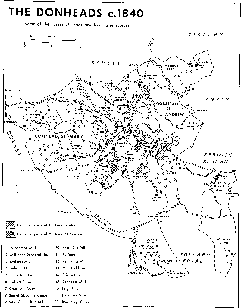
The Donheads c. 1840
The north part of the long east boundary between Donhead St. Mary and Donhead St. Andrew follows a watercourse, and the Nadder marks the boundary for a short distance. A ridge marks Donhead St. Mary's boundary with Berwick St. John and part of that with Tollard Royal, which continues along a coomb. Apart from Shaftesbury, the parish adjoins four Dorset parishes: the boundary with Ashmore is marked by a short stretch of Roman road, that with Melbury Abbas is marked by a ridge, that with Cann crosses the summit of a hill, and that with Motcombe is a road which follows a ridge. The boundary with Semley, on high ground between Donhead St. Mary and Semley villages, was redrawn in 1241 when Shaftesbury abbey and Wilton abbey, the lords respectively of Donhead and Semley manors, agreed to cease intercommoning there. (fn. 8)
The parish is at the west end of the Nadder valley and in the Vale of Wardour. Chalk outcrops in the south part of the parish, Upper Greensand and Gault in the centre and north. The Nadder has deposited a narrow strip of alluvium. (fn. 9) The parish is characterized by its broken relief. The chalk downs reach 277 m. at Win Green and 206 m. on the boundary with Cann. The deepest of the dry valleys to cut them is Quarry Bottom south of Win Green. To the north the greensand has been cut by four head streams of the Nadder, in the narrow and deep valleys of which the Gault has been exposed. The highest land, over 240 m., is in the south-eastern and north-western corners of the parish; the lowest, below 122 m., is beside the Nadder where it leaves the parish. Open fields lay on the northern part of the chalk until the 19th century and the downland south of them was long used to feed sheep in common. (fn. 10) Win Green, which is partly in Donhead St. Mary, was bought by the National Trust in 1937. (fn. 11) The greensand has been both arable and pasture and in places is well wooded: around Wincombe Park and Donhead Hall the land was imparked, respectively, by the 16th century and in the 19th. (fn. 12) The streams have driven several mills and in the 20th century have been used to grow watercress. (fn. 13) There are ponds at the sources of the two which flow eastwards. The whole parish was within the outer bounds of Cranborne Chase. (fn. 14) When the chase was disfranchised in 1829, only the lands of Higher Ashgrove farm were within it. (fn. 15)
The parish is crossed by the Roman road from Badbury Rings in Shapwick (Dors.) to Bath. The road from Tollard Royal to Ludwell marks its course south of the Salisbury-Shaftesbury road and between Five Ways and Ludwell is called Dennis's Road. North of Ludwell the Roman road ran past Lower Berry Court and the church. (fn. 16) Where it crossed the Salisbury-Shaftesbury road at Ludwell a cross may have stood in 1216. (fn. 17) A ridge way mentioned in the later nth century (fn. 18) is a rough track over Win Green, south-west of which it crosses the Roman road. Over Charlton Down its course is followed by a road from Tollard Royal to Shaftesbury. Two main roads serve the parish. The Salisbury-Shaftesbury road, which passes through Birdbush and Ludwell, was part of a main London-Exeter road in 1675 (fn. 19) and 1985. The Warminster-Shaftesbury road is the boundary with Motcombe. Both roads were turnpiked in 1753 and disturnpiked in 1877. (fn. 20) Britmore Lane, linking Donhead St. Mary and Semley villages, and Watery Lane were so called in 1886 and 1533 respectively. (fn. 21) North-west of Charlton a grid of lanes serving Lower Coombe, Middle Coombe, and Higher Coombe is based on the Salisbury-Shaftesbury road. Most lanes which linked the settlements in the parish in the later 18th century were still used in 1985. The north-south lanes linking Higher Coombe to Wincombe Lane and the lane leading westwards from Front Horse Hill Lane south of Donhead Hall went out of use between 1773 and 1840, (fn. 22) presumably when Wincombe Park was built. (fn. 23) Pound Lane, which linked Lower Berry Court to Milkwell in Donhead St. Andrew, and Back Horse Hill Lane went out of use between 1924 and 1950. (fn. 24)
Mesolithic microliths found in the north part of the parish, a Neolithic long barrow near the boundary with Ashmore, bowl barrows on Charlton Down and Win Green, ditches on Charlton Down and Win Green, and Castle Rings, an Iron-Age hill fort near the boundary with Semley are abundant evidence of prehistoric activity. Among the artefacts is a late Bronze-Age metalworker's hoard found on Donhead Clift. (fn. 25)
An area called Donhead, presumably consisting of Shaftesbury abbey's estate called Donhead and including the whole of Donhead St. Andrew and Donhead St. Mary parishes, was the most highly rated in Dunworth hundred in 1334 and the sixth most highly rated in Wiltshire. There were 359 polltax payers in the same area in 1377, a number second in Dunworth hundred only to the total for places in Tisbury parish. (fn. 26) Taxation assessments of the later 16th century and earlier 17th show the parish to have been prosperous and the wealth to have been widely distributed geographically. (fn. 27) The plague was prevalent in Donhead St. Mary in 1665–6. (fn. 28) There were 755 inhabitants in 1695, again apparently widely spread among the settlements in the parish. (fn. 29) The population had increased to 945 by 1801 and to 1,095 by 1811, when of the three tithings into which the parish was divided, Charlton had 466 inhabitants, Dognell 279, and Haystone 350. Numbers had increased to 1,621 by 1851. The decline to 1,482 by 1861 was attributed to emigration and removal to other parishes, and a further decline to 1,375 by 1871 to young men leaving the parish for lack of agricultural employment in it. Numbers declined steadily in the later 19th century and earlier 20th and in 1951 the population was 868. (fn. 30) The building of council and private houses in the parish from the 1950s (fn. 31) reversed the decline and numbers had increased to 934 by 1961, to 952 by 1971. In 1981 the population was estimated at 953. (fn. 32)
Nearly all settlement in the parish has been on the greensand in the north and centre. Donhead St. Mary village, loosely grouped near the church on and around a greensand bluff, may be the oldest. The other principal settlements grew mainly in the valleys of the head streams of the Nadder. Until the 19th century Charlton, where there has been a church from the 14th century, was entirely south of the Salisbury-Shaftesbury road, and was a more nucleated village than Donhead St. Mary. North-east of it Ludwell included settlement beside the main road and had an ancillary hamlet called Birdbush in 1886. In the deep valleys of the streams flowing eastwards there were four hamlets in the later 18th century, Wincombe in the northern valley, Lower Coombe, Middle Coombe, and Higher Coombe in the southern. (fn. 33) In the 19th and 20th centuries while the number of houses in Donhead St. Mary village and in the hamlets in the coombs may have declined, settlement increased at Charlton and Ludwell and along the whole of the east-west line across the parish marked by the Salisbury-Shaftesbury road, and there was some new scattered settlement in the north-west and south parts of the parish.
From the 17th century or earlier Donhead St. Mary village was sometimes called Upper or Over Donhead to distinguish it from the lower-lying Donhead St. Andrew. (fn. 34) Nearly all its buildings are of local sandstone and many have thatched roofs. North-west of the church they include two former schools: the older, on the south-west side of the road, is of brick, stone, and thatch and was used as a library c. 1943; the newer, on the north-east side, became the village hall after 1922. (fn. 35) The former Rectory, Shute House, is on the south-west side of the road, (fn. 36) and Shute Farm on the north-east side was built of stone and thatch in the 18th century and altered in the 19th and 20th. On the east side of Berry Wood Lane east of the church, Pilgrims Cottage incorporates a blocked two-headed door and windows which may be medieval. Its dimensions suggest that it may be the church house built c. 1517 (fn. 37) and afterwards used to house paupers. (fn. 38) On the south-west side of Church Hill, Church Hill House was built of stone and thatch in the 17th century. South-east of the church the houses on the south- west side of the road stand on a greensand embankment. The Royal Oak was apparently built as a public house shortly before 1875: (fn. 39) it was altered c. 1920 and ceased to be an inn between 1966 (fn. 40) and 1985. Burltons, north-east of the road, is an 18th century farmhouse in which the poet and antiquary W. L. Bowles lived 1788–97: the house was altered and enlarged in the early 19th century (fn. 41) and c. 1840 stood in a 7–a. park, (fn. 42) in which a lake was made between 1969 (fn. 43) and 1985. A small Gothic lodge, now derelict, was built beside the road between 1840 and 1886. (fn. 44) Further south, at the junction of the road and a lane leading to West End in Donhead St. Andrew, Glyn Farm was built on the west side in the later 16th century. The house is of stone and thatch and has an east-west range with a cross-passage entrance. A two-storeyed south porch and a northeast parlour were built in the 17th century and in the early 19th the east front was made into an entrance front with sash windows and a central doorway. A house of stone and thatch on the east side of the road bears the date 1712 and the inscription m/eb. More houses stood on the west side south of Glyn Farm in the 18th century (fn. 45) and a row of thatched cottages survives. Donhead brewery was built on the east side in the earlier 19th century, (fn. 46) and in 1868 a Methodist chapel was built on the east side to replace one of 1837 on the west side. (fn. 47) At the south end of the village to the east Lower Berry Court, the demesne farmhouse of Donhead manor, is medieval, and on high ground to the west Donhead Hall is 18th century. South of Donhead Hall is an 18th-century mill house. Collingbeams stands west of Front Horse Hill Lane, a large house of the later 19th century, (fn. 48) and Horse Hill Cottage on the east side of that lane is of the 17th century and later. The houses beside Watery Lane are mainly of local stone and date from the 18th and 19th centuries. East of the south end of the lane a small group of large detached houses in a landscaped setting was built c. 1980.
In the 18th century, and apparently earlier, Wincombe was a hamlet consisting of buildings beside the lane south of, and parallel to, Wincombe Lane. (fn. 49) Castle Farm on the north side dates from the 17th century, and has a long north-south range with a central chimney stack and cross passage. The house was heightened, and the thatched roof replaced by a tiled one, c. 1980. (fn. 50) Lower Wincombe Farm on the south side was built in the early 19th century and enlarged in the later 19th. Clusters of houses at the west and east ends of the lane are mostly 19th- and 20th-century. West of Wincombe there were four farmsteads in 1768. East Leaze Farm and Wincombe Farm were built in the later 18th century. Wincombe Farm was enlarged in the 19th: a barn and other buildings west of it may be of the earlier 18th century. In the north-west corner of the parish, East Heath Farm may incorporate parts of an early 19th century building, and Ramshill Farm, a small symmetrical stone house, was built in the early 19th century apparently on the site of an older building. (fn. 51) Wincombe Park was built between 1808 and 1824. (fn. 52)
Near the junction of the Roman road, there called Dennis's Road, and the Salisbury-Shaftesbury road, Ludwell was a village strung out mainly along the south side of the Salisbury-Shaftesbury road in 1675 and 1768. (fn. 53) West of the junction, at the bottom of Ludwell Hill, so called in the 19th century, there were buildings on both sides of that road. A nonconformist chapel called Birdbush was built east of Dennis's Road in the early 18th century: by 1886 the settlement beside the Salisbury-Shaftesbury road north-east of it had assumed the name Birdbush. (fn. 54) North of the Salisbury-Shaftesbury road Ludwell Mill is linked to the village by Cats Hill Lane. South of the village near Five Ways, Peckons Hill Farm, a house and extensive farm buildings, was built between 1840 and 1886, (fn. 55) and additional farm buildings were erected in the 20th century. Beside Dennis's Road 12 council houses were built between 1936 and 1938. (fn. 56) The oldest building to survive at Ludwell is the Grove Arms at the bottom of Ludwell Hill. It was called the Talbot or Black Talbot in the period 1579–1811, the Black Dog after 1811, and was renamed the Grove Arms in the years 1880–5. (fn. 57) The building contains 16th-century work in its north-west and south-east range, which has a southeast entrance front of three bays. In the earlier 18th century a five-bayed range, in the west corner of which a contemporary fireplace survives, was built to the south-west, and in the 19th century a kitchen wing was built to the north-west. A friendly society with 50 members may have met there in 1803. (fn. 58) Another friendly society, the Hope Society, was registered to meet there in 1836 (fn. 59) but had ceased to do so before 1906. (fn. 60) Grove House, opposite the Grove Arms, was a nursing home 1939–66 (fn. 61) and a hotel in 1985. South of the Salisbury-Shaftesbury road and east of Dennis's Road, Birdbush Farm was standing in 1768: (fn. 62) a pair of cottages built between 1840 and 1877 (fn. 63) was in single occupation in 1901 (fn. 64) and 1985. The Lamb, at the junction of Dennis's Road and the Salisbury-Shaftsbury road, was an inn from 1867 or earlier to 1966 (fn. 65) or later. Most of the other buildings at Ludwell and Birdbush in 1985 were cottages and houses of stone, with tiled roofs, of the 19th and 20th centuries.
Its name suggests that Charlton originated as a village of small farmsteads. (fn. 66) In 1768 the village consisted of small farmhouses beside a street which runs south from the Salisbury-Shaftesbury road. (fn. 67) A church had been built on the east side by the 14th century. (fn. 68) On the east side Middle Farm is of 1710 (fn. 69) and comprises a long east-west range. In the 19th and 20th centuries Charlton was greatly altered by new building at its north and south ends. North of the village, on the east side of the street, Charlton House was built c. 1821 on the site of an earlier farmhouse, (fn. 70) and in 1839 the church was demolished and a new one built at the junction of Front Horse Hill Lane with the Salisbury-Shaftesbury road. (fn. 71) From 1842 the village school has also stood north of the Salisbury-Shaftesbury road. (fn. 72) East of Front Horse Hill Lane 65 council houses and bungalows were built 1946–66, and private houses were built north of the church. (fn. 73) South of the village, on the south side of the lane leading to Five Ways, Manor Farm, a stone farmhouse with large red-brick buildings east of it, was built in the mid 19th century. (fn. 74) There were several buildings beside the lane in 1840; (fn. 75) others were erected in the 20th century. In the street itself Home Farm on the west side and in Watery Lane Hollybush Farm, later called Greystones, on the south side were rebuilt in the mid 19th century.
West of Charlton the only house to stand beside the Salisbury-Shaftesbury road in 1773 (fn. 76) was that which became the Rising Sun inn, on the north side. It was built in the 18th century and enlarged in the 19th. It was a beer shop c. 1840 (fn. 77) and in 1855, an inn in 1859 (fn. 78) and 1985. Several other houses, including Knight's Barn Farm, were built between 1773 and 1840, and further west more were built in the 20th century. Landsley House stood north of the road near the parish boundary in 1773 and 1840. (fn. 79) A new farmhouse called Landsley Farm was built north-west of it in the later 19th century. (fn. 80)
The hamlets of Lower Coombe, Middle Coombe, and Higher Coombe are linked by a lane parallel to the Salisbury-Shaftesbury road. Each hamlet contains stone farmhouses: some are thatched and several are 17th-century. Lower Coombe Farm at the lane's eastern end on the north side was built on the site of an earlier house (fn. 81) in the later 18th century. A large, partly timber-framed, barn dated 1759, stands south-west of it. From the later 16th century members of the Pond family were tenants, (fn. 82) and three memorial stones north of the house commemorate members of that family who died of the plague in 1665. The hamlets of Middle Coombe and Higher Coombe are north of the lane beside narrow roads across well wooded parts of the valley. In Higher Coombe, Coombe Priory was so called before 1848 (fn. 83) from its association c. 1800 with a group of French Carthusian monks. (fn. 84) It was built in the 17th century and was enlarged and much altered in the mid and later 20th. West of Higher Coombe, Nunswell was built c. 1876 (fn. 85) on the site of Guildings Farm which stood c. 1840. (fn. 86) On high ground at the west end of the valley in which the three hamlets lie Coombe House was built in 1886 for M. H. Beaufoy. (fn. 87) Two stone farmhouses were also built for Beaufoy, one between Lower Coombe and Middle Coombe in 1903, one at Higher Coombe in 1904. (fn. 88)
A farmstead called Higher Ashgrove, later Middle Ashgrove, stood at the south end of the parish from the late 16th or early 17th century; (fn. 89) in 1773 there was a second farmstead, Lower Ashgrove; (fn. 90) and by 1840 a third farmstead, called Higher Ashgrove, of which only a cottage was in Donhead St. Mary, had been built. (fn. 91) Middle Ashgrove was demolished before 1948. (fn. 92) The farmhouse of Lower Ashgrove, of brick and thatch in 1901, (fn. 93) was demolished between 1927 and 1958. (fn. 94) The new Higher Ashgrove is a later 19th-century house of stone and flint. A pair of cottages was built west of it in the earlier 20th century. (fn. 95) South-east of Ludwell, barns on Berry Court farm were standing in 1773. (fn. 96) A new farmhouse, Higher Berry Court, was built west of them between 1820 (fn. 97) and 1840, (fn. 98) perhaps with stone from the demolished Ashcombe House in Berwick St. John. (fn. 99) The symmetrical north-west front is of three bays. The house was extended to the south-west in the later 19th century. Extensive farm buildings were built south and east of it in the later 19th and the 20th centuries. Cottages, including a pair built of brick, are possibly on the site of the barns which stood until 1820 (fn. 100) or later.
Manors and other Estates.
An estate called Donhead, which was given to Shaftesbury abbey in the period 871–7 by King Alfred and confirmed to it in 956 by King Edwy, (fn. 101) was assessed at 40 hides in 1066 and 1086. (fn. 102) The estate, later called the manor of DONHEAD, included nearly all of what became the parishes of Donhead St. Mary and Donhead St. Andrew and was held by Shaftesbury abbey until the Dissolution. (fn. 103) The income from the estate was used in the early 12th century to provide clothing for the nuns. (fn. 104) The abbey was granted free warren in its demesne lands in the manor in 1293. (fn. 105) In 1544 the Crown granted the manor to Sir Thomas Arundell, (fn. 106) on whose attainder and execution in 1552 it was forfeited. (fn. 107) It was granted in 1552 to Lord Thomas Grey (fn. 108) but, on his attainder and execution in 1554, (fn. 109) was again forfeited. In 1554 the Crown granted the manor to Margaret Arundell, relict of Sir Thomas, to pay her husband's debts, and, after the debts were paid, to Sir Thomas's son Matthew, knighted in 1574. (fn. 110) From Sir Matthew (d. 1598) (fn. 111) the manor passed in the direct male line to Thomas (cr. Baron Arundell of Wardour in 1605, d. 1639), (fn. 112) Thomas (d. 1643), and Henry (d. 1694), who forfeited it as a royalist. Henry, Baron Arundell, bought the manor from the state in 1653, (fn. 113) and it again passed in the direct male line to Thomas (d. 1712), Henry (d. 1726), Henry (d. 1746), Henry (d. 1756), and Henry (d. 1808). That last Henry was succeeded by his nephew James Arundell (d.1817), and James by his sons James (d. 1834) and Henry (d. 1862) in turn. In the earlier 19th century most of the manor in Donhead St. Mary was sold piecemeal. The lands which were sold included farms based at Wincombe and Higher Berry Court farm and nearly all the farms based at Charlton, Lower Coombe, Middle Coombe, and Higher Coombe. The land which was not sold, c. 320 a. including much of Lower Berry Court farm, descended as part of the Wardour estate (fn. 114) to R. J. A. Arundell (d. 1953) who sold most of it in 1946. (fn. 115)
In 1822 James, Baron Arundell, sold Water Street farm, c. 50 a., Castle farm, c. 55 a., and Wincombe farm, c. 35 a., all at Wincombe, to Edward Baker (fn. 116) (d. 1862) (fn. 117) who owned the land in 1840. (fn. 118) The descent of the three farms has not been traced further. Lord Arundell sold Lower Wincombe farm in 1821 to William Horder. (fn. 119) In 1840 it measured 118 a. and was owned by that or another William Horder, (fn. 120) but has not been traced further.
The demesne land of Donhead manor was called Berry Court farm, and much of it was in Donhead St. Mary. From 1582 or earlier leases of it descended in the Grove family with Ferne manor in Donhead St. Andrew. (fn. 121) In 1808 Lord Arundell sold c. 300 a. south of the Salisbury-Shaftesbury road to Thomas Grove (d. 1847), and the land became Higher Berry Court farm. (fn. 122) The farm descended with Ferne manor to Sir Walter Grove, Bt., who sold it, by then enlarged and including 580 a. in Donhead St. Mary, c. 1901 (fn. 123) to A. H. Charlesworth (d. 1914). (fn. 124) In 1914 Charlesworth's executors sold it to Albert Aish (d. 1922). Aish's relict in 1925 settled the farm jointly on her granddaughters Miss Ann Finlay and Miss Helen Finlay, later Mrs. J. S. Blanchard, who in 1955 sold their shares in Higher Berry Court farm, then 320 a., to Mr. A. J. W. Stancomb, the owner in 1985. (fn. 125)
R. J. A. Arundell in 1946 sold Lower Berry Court farm, 175 a. of which 131 a. were in Donhead St. Mary, (fn. 126) to Mr. R. E. Coward, whose son Mr. M. R. Coward was the owner in 1985. (fn. 127)
Berry Court was the demesne farmhouse of Donhead manor. The central north-east and south-west range, in which the smoke-blackened cruck roof of an open hall survives and through which the boundary between Donhead St. Andrew and Donhead St. Mary runs, and the south end of the house are medieval. The north end of the house was rebuilt in the early 17th century, perhaps for John Grove (d. 1629), who lived in it, (fn. 128) and an east wing was built, perhaps as a kitchen, in the later 17th century, possibly for Robert Grove (d. 1695), who may have lived there c. 1669. (fn. 129)
In 1946 Glyn farm, 22 a., was bought by R. Burton: in 1985 it belonged to Mr. R. P. R. Burton. (fn. 130) Donhead Clift farm, c. 36 a., was bought in 1946 by L. A. Hiscock. (fn. 131)
In 1819 James, Baron Arundell, offered for sale 74 a. in Charlton. (fn. 132) Those lands, on which a house called Hillside Farm was built south of the Salisbury-Shaftesbury road, (fn. 133) were part of a 109–a. farm owned by Sir Richard Glyn, Bt. (d. 1918), in 1868. (fn. 134) Glyn's son, Sir Richard Glyn, Bt., offered Hillside farm, then 24 a., for sale in 1919. (fn. 135) Thereafter its descent has not been traced.
Lord Arundell in 1821 sold a house called Charlton Cottage and 33 a. to George South. In 1825 South sold them to J. P. Coffin (d. 1830), whose trustees sold them in 1831 to Thomas Du Boulay. Robert Graves bought the estate from Du Boulay in 1835. (fn. 136)
Graves (d. 1849) had bought most of the land of Charlton, c. 770 a. in 39 small farms, from Lord Arundell in 1823. (fn. 137) Between 1849 and 1862 his son Robert Graves bought another 150 a. or more of Charlton land. (fn. 138) From the younger Robert Graves (d. 1874), his CHARLTON estate passed in the direct male line to A. R. Graves (d. 1880) and R. B. Graves, who assumed the additional surname Knyfton in 1895. (fn. 139) A. R. Graves and R. B. Graves bought more land and in 1912, when R. B. GravesKnyfton offered it for sale, it comprised 1,266 a. and included five large farms. (fn. 140) Charlton Cottage, built on the site of the earlier house of that name north of Charlton village on the east side of the street, apparently for George South c. 1821, became the principal house of Robert Graves's estate in 1835 (fn. 141) and was renamed Charlton House between 1848 and 1855. (fn. 142) It is a large square two-storeyed house of ashlar with an iron verandah along the south side. A service wing runs east from the north-east corner of the house to a large stable court.
The Charlton estate was sold in portions in 1913. (fn. 143) Charlton House and a 30–a. park were bought by Edith, dowager Baroness Wynford (d. 1924), and her daughter Gertrude Best. (fn. 144) They were bought from H. C. R. Brocklebank, the owner c. 1955, in 1958 by Mr. R. K. Hedges, the owner in 1985. Job Greenwood bought Charlton Middle farm, 124 a., and between 1924 and 1965 it was owned by F. H. Greenwood. Mr. R. K. Hedges bought 115 a. of it in 1965 and owned them in 1985. (fn. 145) Hollybush farm, 59 a., was bought by G. Flower and was sold in portions by members of the Flower family after c. 1952. Home farm, 122 a., was bought by Charles Mullins and passed from his son Ernest to Ernest's son Mr. John Mullins, the owner in 1985. Manor farm, 556 a., was bought by S. J. Blanchard (d. 1927), from whom it passed successively to his son Roy (d. 1978) and grandson Mr. J. S. Blanchard. Peckons Hill farm, 105 a., was bought by Jane Hare. Her nephew William Tatchell sold it in 1942 to Mr. J. S. Blanchard. Through Peckons Hill Farms Ltd. Mr. Blanchard owned Manor farm and Peckons Hill farm in 1985. (fn. 146)
In 1768 Donhead manor included 855 a. in 14 farms in the three Coombes. (fn. 147) Most of it was sold in the early 19th century though in 1840 Henry, Baron Arundell, owned a 60–a. farm at Middle Coombe. (fn. 148) In 1822 Edward Baker, who already owned the 60–a. farm at Higher Coombe owned by his father Edward in 1768, bought three farms, a total of c. 56 a. at Higher Coombe and of c. 190 a. at Lower Coombe. (fn. 149) By 1840 Baker's COOMBE estate had been increased to 429 a. (fn. 150) In 1885 or earlier it belonged to M. H. Beaufoy who c. 1922 owned 608 a. (fn. 151)
Beaufoy's estate c. 1922 included the house later called Coombe Priory and 150 a. at Higher Coombe which Henry, Baron Arundell, had sold to James Knight in 1806. (fn. 152) Charles Knight in 1840 owned Knight's farm, 124 a. including a farmstead at the junction of the Salisbury-Shaftesbury road and the lane to Higher Coombe. (fn. 153) The estate c. 1922 also included Guildings farm at Higher Coombe, 93 a. in 1806. (fn. 154) That farm was sold by James, Baron Arundell, in 1810 (fn. 155) to Charles Bowles (d. 1837), passed to Bowles's daughter Margaret Bowles, was of 145 a. in 1840, (fn. 156) and was sold c. 1876. (fn. 157)
M. H. Beaufoy (d. 1922) was succeeded by his son H. M. Beaufoy, (fn. 158) who in 1923 sold Coombe Priory and six farms piecemeal (fn. 159) but retained Coombe House and 50 a.
Coombe House and a stable block north of it were built for M. H. Beaufoy in 1886. The house was designed by E. T. White in a 16th-century style and is of local greensand with dressings of red stone from Monkton Farleigh. (fn. 160) It stands on a spur between two wooded coombs. To the south-east a fishpond fed by a spring forms an ornamental lake in landscaped gardens and provided a water supply for the house. (fn. 161) It was perhaps the spring at which Charles Bowles, the owner of the land in the earlier 19th century, erected a stone engraved with Latin verses composed by the Revd. W. L. Bowles. (fn. 162) The principal rooms were on the gabled south-east side of the house and faced the garden. Short wings projected on the north-west side to form an entrance court. The south wing was enlarged to incorporate a ballroom in 1911. (fn. 163)
Coombe House and 50 a. were sold c. 1930, and the house became a hotel between 1931 and 1935. It was owned in 1935 by a Mr. and Mrs. Whitaker, and in 1939 by S. Wormald. (fn. 164) During the Second World War it was used by the American Red Cross as a convalescent home for airmen. The house and land surrounding it were bought in 1945 by the sisters of the Institute of the Blessed Virgin Mary, who opened St. Mary's Convent school for boarding and day girls in it and were the owners in 1985. (fn. 165) A chapel, refectory, and classrooms were built in the 1960s in the style of the house; in the 1980s laboratories were erected, and the north wing of the house was extended to accommodate the convent.
In 1066 and 1086 Shaftesbury abbey's Donhead estate included 1 hide held by a thegn. (fn. 166) It may have been the hide at Ashgrove later claimed by Thomas, a kinsman of Eulalia, abbess of Shaftesbury (appointed 1074), against whom the abbey had by c. 1122, when Henry I confirmed the estate as part of its demesne lands, re-established its title. (fn. 167) The hide was what became the manor of Ashgrove. At the Dissolution the estate passed to the Crown, the owner in 1570. (fn. 168) In 1574, however, it was judged to have been included in the grant of Donhead manor made in 1544 to Sir Thomas Arundell and was given to Sir Matthew Arundell. (fn. 169) It was divided into two farms, one of which was sold.
LOWER ASHGROVE farm descended with the manor of Donhead. (fn. 170) In 1815 James, Baron Arundell, sold the farm, 304 a., to Thomas Grove (d. 1847). (fn. 171) From Grove it passed like Ferne manor in the direct male line to John Grove (d. 1858), Sir Thomas Grove, Bt. (d. 1897), and Sir Walter Grove, Bt., who c. 1901 sold the farm, 132 a. including 10 a. in Tollard Royal, to A. H. Charlesworth (d. 1914). (fn. 172) M. F. Martin was the owner 1924–31, (fn. 173) and Mr. H. Borley 1945–85. It was then part of a larger estate which included Higher Ashgrove farm and land in the south part of Berwick St. John and the north part of Tollard Royal. (fn. 174)
HIGHER ASHGROVE farm, with other land in Donhead St. Mary and Tollard Royal, was owned in 1578 by William Cox, from whom it passed to his son Charles. In 1606 Charles and his wife Joan sold it to Stephen Fry (fn. 175) (d. 1619). Fry devised the farm to his son Thomas (fn. 176) (fl. 1640): (fn. 177) it passed to Thomas's son William (d. 1708) and to William's son Thomas. (fn. 178) In 1719 Thomas Fry settled it on his son Stephen, whose son John, the owner in 1768, sold the farm c. 1778 to William Brewer. Brewer's son John sold it in 1808 to R. H. G. Philp who sold it to his father Richard Philp in 1809, succeeded his father in the land in 1824, and in 1832 sold the farm, 394 a., to Ann and Honor Brown. (fn. 179) Thomas Grove (d. 1845) bought the farm from them in 1833 and in 1840 sold it to his father Thomas Grove (fn. 180) (d. 1847). Higher Ashgrove farm descended like Lower Ashgrove farm to Sir Walter Grove, Bt.: in 1901 it measured only 150 a. including 50 a. in Tollard Royal. (fn. 181) It was bought by A. H. Charlesworth and passed with Lower Ashgrove farm. Higher Ashgrove Farm was of stone and thatch, had two large gables, and was possibly built in the later 16th or earlier 17th century. (fn. 182) It may have been the house called Fry's c. 1618. (fn. 183) By 1840 a cottage and barns had been built further west on the boundary with Tollard Royal. They were called Higher Ashgrove, and the old house was renamed Middle Ashgrove Farm. It was abandoned between 1901 and 1905, and was demolished before 1948. (fn. 184)
Land in the north-west part of the parish belonged to Shaftesbury abbey in the Middle Ages, not as part of Donhead manor but as part of the abbey's barton, which included WINCOMBE PARK, 60 a. with a warren, and an 80–a. inclosed pasture called the HEATH. (fn. 185) It was granted to Sir Thomas Arundell in 1545. (fn. 186) After the attainder and execution of Sir Thomas in 1552, (fn. 187) the lands were granted to William Herbert, earl of Pembroke (fn. 188) (d. 1570), and passed with the Pembroke title to Philip, earl of Pembroke and Montgomery (d. 1669), (fn. 189) who apparently sold the estate piecemeal c. 1650. (fn. 190)
Luke Weekes (d. 1688) owned Wincombe park and devised it to his elder son Reynaldo Weekes. (fn. 191) William Benson (d. 1754), M.P. for Shaftesbury 1715–19 and a patron of architects, owned it in the earlier 18th century (fn. 192) and may have sold it in portions. Part was bought by Godfrey Huckle Kneller (d. 1781), whose son John Kneller sold (fn. 193) 80 a. in 1808 to John Gordon. (fn. 194) Other land called Wincombe Park farm, probably the 137–a. farm owned in 1768 by William King, belonged in 1801 to John Benett, (fn. 195) who apparently sold the farm, then 162 a., in 1807 to a Mr. Hinxman. (fn. 196) John Gordon (d. 1834) owned the farm in 1813. It passed to his wife Maria (d. 1852), (fn. 197) who in 1840 owned Wincombe House and its park of 153 a., Wincombe Park farm (later Wincombe farm), 211 a., and another 41 a. (fn. 198) From Maria Gordon the estate passed to John Gordon's nephew Charles Gordon (d. 1897). It descended in the direct male line to George Gordon (d. 1928) and Reginald Gordon, the owner in 1952. (fn. 199) The estate was afterwards bought by the historian Sir Arthur Bryant, the owner in 1955–6. (fn. 200) He sold it in 1961–2 to the Hon. Martin Fortescue, who owned c. 400 a. in the north-west part of the parish in 1985. (fn. 201)
John Gordon built Wincombe House, later Wincombe Park, before 1824 on land bought in 1808. (fn. 202) The house, of local greensand ashlar and described c. 1825 as a 'cottage-villa', (fn. 203) stands on the north side of a wooded valley where between 1773 and c. 1807 Wincombe pond was divided into two lakes. (fn. 204) The west range has a recessed central doorway and contains the principal rooms. The service rooms are in the lower east range and its northern extension. A verandah, of which a section survived in 1985, was built the length of the south front in the later 19th century. A lodge south of Wincombe Lane was built in the period 1811–40. (fn. 205)
The Heath may have been represented in 1768 by Heath farm, 87 a., owned by John Tatum. (fn. 206) In 1840 George Case owned the land, then called East Heath farm (fn. 207) and so called c. 1807 or earlier. (fn. 208) The farm was part of the Wincombe Park estate in 1985. (fn. 209)
Before 1606 Laurence Mountier owned an estate called HALLAM place. It descended to his daughters and coheirs, Mary, wife of Sebastian Pitfold, and Jane, wife of Edward Elliott : in 1608–9 Sebastian and Mary Pitfold and Edward and Jane Elliott sold it to Thomas Bellott, (fn. 210) who conveyed it to Bath corporation to endow an almshouse in Bath. The estate was of c. 60 a. in Charlton with a farmhouse east of that village. (fn. 211) In 1858 Bath corporation exchanged Hallam Farm and 56 a. with Henry Hancock for land elsewhere. (fn. 212) Hancock in 1858 sold the farmhouse and 45 a. to Robert Graves and they became part of Graves's Charlton estate. (fn. 213) In 1875 Bath corporation sold its few remaining acres to A. R. Graves. (fn. 214) Hallam Farm was demolished between 1858 and 1886. (fn. 215)
In 1658 Reynaldo Weekes (d. 1682) owned lands which became the DONHEAD HALL estate. He devised them to his wife Mary for her widowhood with remainder to his nephew Luke Weekes (fn. 216) (d. 1688), who devised the lands to his younger son Luke (fn. 217) (d. 1730). They passed to that Luke's daughter Mary (d. 1744), the wife of Godfrey Huckle (d. 1781), who took the surname Kneller in 1731. From Mary the lands passed to Godfrey, from Godfrey to his son John Kneller (d. 1811), and from John to his son Godfrey who sold the estate in 1825 to Charles Wyndham. The estate, originally c. 82 a., was augmented in 1808 and 1828 when land was bought from the Barons Arundell. (fn. 218) In 1840 it was of 178 a. and included two parks, Higher, 12 a., and Lower, 19 a. (fn. 219) From Wyndham (d. 1846), the estate passed to his relict Maria (d.1859). (fn. 220) It was owned in 1859 by John Du Boulay (fn. 221) (d. 1895), whose executors sold the 214–a. estate in 1896 (fn. 222) to H. B. Blackburn, the owner in 1939. (fn. 223) H. C. R. Brocklebank bought the estate in 1943, and sold it in 1950 to Mrs. V. Tennant. She sold it in 1957 to Mr. T. W. Horn, the owner in 1985. (fn. 224)
Donhead Hall (fn. 225) was built in the early 18th century for Godfrey Huckle, later Kneller (d. 1781), on an eastwards-facing slope. The symmetrical house is of local greensand ashlar and has a high basement and two principal storeys. Its design has been attributed to Thomas Archer. The basement, the quoins of the corner pilasters, and the architraves of the windows are all heavily rusticated. The three central bays of the seven-bayed principal east front project on quadrants which are matched by the rounded south-west and north-west corners of the central groundfloor room. That room was originally the entrance hall and the plasterwork of its ceiling incorporates the arms of Godfrey Kneller and his first wife Mary Weekes. (fn. 226) In the early 19th century a single room, the windows of which were lowered, was made from the two ground-floor rooms in the five-bayed south elevation, and a terrace on an arcade was constructed along its length. At the same time a small conservatory was erected on higher ground west of the house and was afterwards linked to the terrace by an arcaded walk and a stair. A new entrance hall and a service stair were built on the north side of the house in the later 19th century. Outbuildings north of the house include a contemporary stable. A lodge was built north of the house c. 1960 to the designs of Mr. Mervyn Herbert. (fn. 227)
In 1693 Thomas Mullins and his wife Ann settled BIRDBUSH farm, 75 a., on Margery Fezzard, possibly their daughter, for life, with remainder to Margery's husband Richard Fezzard. From Margery and Richard the farm descended to their son Richard (will proved 1726), who devised it to his daughter Elizabeth, later the wife of John Mansfield. In 1763 the Mansfields' son James sold Birdbush farm to the trustees of Tisbury charities, (fn. 228) who sold it in 1877 to Sir Thomas Grove, Bt. (fn. 229) From Sir Thomas (d. 1897) the 63–a. farm passed to Sir Walter Grove, Bt. It was bought c. 1901 by A. H. Charlesworth. (fn. 230) Its later history has not been traced.
In 1389 Alan of Ferne or Poulshot, lord of Ferne manor, granted a house, 10 a., and the reversion of other lands in the parish to Robert Fovant. (fn. 231) In 1407 Fovant's feoffees conveyed the reversion of 34 a. to Shaftesbury abbey to endow a chantry at the altar of St. Catherine, St. Margaret, and St. Faith in the abbey church. (fn. 232) Part of the land, a small farm in Charlton called Collingbourne's place, had been added to Easton Bassett manor, most of which was in Donhead St. Andrew, by 1748. (fn. 233) Robert, earl of Pembroke and Montgomery, in 1854 sold c. 30 a. of the farm to J. G. Raymond. Robert Brown bought that land from Raymond in 1857 and sold it in 1861 to Robert Graves, (fn. 234) who added it to his Charlton estate.
A house in Charlton was an endowment of the chantry of St. Anne de la Gore in the parish of St. James, Shaftesbury. (fn. 235) It was granted by the Crown in 1548 to Thomas Boxley and Robert Reeve (fn. 236) and in 1549 was sold by Boxley to Peter Maunsell. (fn. 237) In 1595 Peter Maunsell, perhaps the same, sold a house and 22 a. in Charlton to John Maunsell, who in 1610–11 sold them to Robert Middleton. (fn. 238) The estate was presumably afterwards bought by a Baron Arundell and added to Donhead manor.
Economic History.
In 1066 and 1086 Shaftesbury abbey's estate called Donhead was of 40 hides and could support 32 ploughteams. On the 12 demesne hides were 2 ploughteams, and on the tenantry lands were 35 villani and 25 bordars with 25 ploughteams. There were 15 a. of meadow land, and pasture which measured 1 league in length and breadth. The 40 hides included 6 hides that became Easton Bassett manor, and possibly included 1 hide that became Ashgrove manor and 2 hides that became Ferne manor. (fn. 239)
Donhead manor included most of the land of Donhead St. Mary and Donhead St. Andrew parishes. (fn. 240) The demesne land and the demesne farmhouse itself were crossed by the parish boundary, and until the 19th century or later several farms had lands in both parishes. From 1225 or earlier most of the customary holdings of the manor seem to have been based in Donhead St. Mary parish. There they had land in all parts of the parish except Ashgrove, and included farmsteads in Donhead St. Mary village and at Charlton, Ludwell, Lower Coombe, Middle Coombe, Higher Coombe, and Wincombe. (fn. 241) Ashgrove is referred to separately, below.
In 1225 the demesne of Donhead manor was apparently in hand, and there were 136 tenants of the manor. There was some sheep-and-corn husbandry: flocks totalling 1,573 sheep were kept, but only 50 were kept on the demesne and two thirds of the tenants had no sheep. A total of 242 oxen was kept by 78 of the tenants, and a total of 168 cows by 110 of the tenants, figures which suggest that most of the population of the parish depended on arable and dairy farming. (fn. 242)
The open fields in Donhead St. Mary parish were mainly south of the Salisbury-Shaftesbury road and were called Donhead or Charlton field. (fn. 243) They had been divided by 1317 and there were fields called West, Middle, and East c. 1575 and later. There was a fourth open field, called Coombe, c. 1575 but apparently not later: it may also have been south of the road. South of the open fields and on the chalk a common down was called Broad Down, later Charlton Down, 266 a. in 1768. In the north part of the parish there were common pastures called the Heath, North Down, and Flitmore near the boundary with Semley: in 1235 freemen of Donhead manor were granted pasture rights in them, (fn. 244) and they may have remained uninclosed when the boundary with Semley was redefined in 1241. (fn. 245) In the west part of the parish there were common pastures called Wincombe and Landsley. Most of the northern and western commons had been inclosed by c. 1575, but common husbandry in the south part of the parish persisted until the 19th century. The lanes of the parish also provided common pasture assessed at 103 a. in 1768.
In 1450 the demesne lands of the manor, in both parishes, were in hand and used for sheep-and-corn husbandry. In that year sheep were reared, stock was exchanged with one of Shaftesbury abbey's Dorset manors, 429 fleeces were sent to the abbey's woolhouse, and at Michaelmas there were 472 sheep on the demesne. More oats than wheat or barley were produced and some of it was reserved for the abbess's carthorses which had been brought from Shaftesbury to draw stone for work on the demesne farm buildings. The abbess employed 1 hayward, 1 oxherd, 2 ploughmen, 2 drovers, 1 shepherd, 1 swineherd, 1 full-time and 1 part-time cowherd, and 1 part-time carter. Although weeding duties were still owed by 12, and binding and carrying duties by 14, customary tenants, the tenants had to be paid to mow. (fn. 246)
The demesne farm, Berry Court, c. 1575 included 30 a. of meadows, c. 100 a. of lowland pastures, c. 43 a. of woodland, 114 a. in the open field in Donhead St. Mary parish, and 100 a. of downland pastures. The land was then leased in 11 portions for 5–year terms. The rents included money in place of 20 qr. of wheat, 10 qr. of barley, and 30 qr. of oats which before the Dissolution had been paid at Shaftesbury abbey's granary. The demesne included a hopyard. Obligations of 5 tenants to plough, hoe, reap, and stack, of 4 to reap, and of 23 to mow in Long mead were referred to c. 1575 but not later. (fn. 247) From 1582 or earlier to the early 19th century the whole demesne farm was leased to members of the Grove family of Ferne. (fn. 248) In 1768 it measured 674 a. and included 351 a. in Donhead St. Mary parish. (fn. 249)
There were 24 copyholds based in Donhead St. Mary village and Wincombe c. 1575. The land of all but two was entirely inclosed, was presumably north of the Salisbury-Shaftesbury road, and included pasture inclosed from the commons in the north and west: the two exceptions had land in the open fields. In 1599 there were in addition three freeholds. Of the copyhold farms, 1 had 2½ yardlands, 1 had 2 yardlands, and 22 had fewer than 40 a. each. (fn. 250)
There were 14 copyholds and 1 leasehold based in Lower Coombe, Middle Coombe, and Higher Coombe c. 1575. Four copyholds had land and pasturage in Coombe field, apparently still open, and one had pasture rights on Landsley common. Another four had land and pasturage in the other three open fields. The farms included pasture inclosed from Wincombe common and the Heath. Of the 14 copyholds, 1 was of 2 yardlands, 1 of 1½ yardland, 8 of 1 yardland, 1 of ½ yardland, and 3 of only a few acres each. The leasehold, Ponds, later Lower Coombe, farm, was of 48 a.: it included land in the three main open fields, 13 a. of inclosed meadow and pasture, and 23 a. inclosed from Wincombe common and the Heath. (fn. 251)
All the 21 farms based at Charlton and, presumably, Ludwell c. 1575 were copyholds: 2 were of 2 yardlands, 11 of 1 yardland, 2 of ½ yardland, and 6, of which 2 included mills, were of only a few acres. Except for some of the smallest, all had lands in the open fields and pasture for between 60 and 120 sheep each on Broad Down. Five had land inclosed from common land at Charlton and from Wincombe common and the Heath. (fn. 252) In 1599 there were also three freeholds. (fn. 253)
In 1768 there were freehold farms based in Donhead St. Mary village and at Wincombe: 3 were of 100–150 a. and 2 of 50–100 a. A freehold of 60 a. was based at Higher Coombe, and 3 of 50–100 a. at Charlton. Much land in the parish was converted from copyhold to leasehold between 1599 and 1768. In Donhead St. Mary and Wincombe in 1768 there were 7 leaseholds of which 2 were of 50–100 a. and 5 of fewer than 50 a.: all 5 copyholds had 50 a. or less. In the Coombes there were a 59–a. farm held at will, 11 leaseholds, of which 2 were of 100–150 a. and 9 of fewer than 50 a., and 7 copyholds, of which 2 were of 100–150 a. and 5 of fewer than 50 a. In Charlton there were 3 farms called Charlton: 2 were leased and were of 174 a. and 40 a., and 1 was of 79 a. and held at will. A 10–a. farm was also held at will. There were 7 other leaseholds of which 2 were of 50–100 a. and 5 of fewer than 50 a. Of the 10 copyholds, 1 was of 50–100 a. and 9 of fewer than 50 a. Land in the open fields belonged to 14 farms, and 11 farms included rights to feed a total of 639 sheep on Broad Down. (fn. 254)
Between 1806 and 1823 most of the farms in the parish were severed from Donhead manor, and the pattern of farming was radically altered. The 300 a. of Berry Court farm in the south became a separate farm, Higher Berry Court, in 1808. At Wincombe, Lower Wincombe, 118 a., Wincombe, c. 35 a., Castle, c. 55 a., and Water Street, c. 50 a., were farms in the early 19th century. Wincombe farm merged with Castle farm, which in 1840 was of 142 a. Of the other farms based at Wincombe in 1840, Lower Wincombe still had 118 a., Wincombe Park farm, including Ramshill farm, was of 211 a., and Water Street farm was of 43 a.; Wincombe park was of 153 a. In the north part of the parish East Heath farm had 83 a. North of Donhead St. Mary village Shute farm had 38 a. The only farmstead in the village was Glyn Farm. South of the village Donhead Hall farm had 178 a., including the parks, and Lower Berry Court 80 a.: the 298 a. of Higher Berry Court were all south of the Salisbury-Shaftesbury road. In the early 19th century there were farms of 145 a., 130 a., 107 a., 60 a., c. 56 a., 29 a., and 14 a. in the three Coombes. By 1840 the lands of the last three and other lands had become Knight's farm, 124 a., and a 46–a. farm. In the later 19th century they all became part of the Coombe estate on which Coombe House was built and land was imparked. (fn. 255) In 1923 c. 209 a. were worked for the owner and the farms included Lower Coombe farm, 118 a., Grove farm, 92 a., Knight's Barn farm, 41 a., Landsley farm, 43 a., Windwhistle farm, 55 a., and Guildings farm, 56 a. (fn. 256) The 770 a. in 39 small farms based at Charlton and Ludwell which Robert Graves bought in 1823 (fn. 257) had by 1840 been made into 3 farms, Charlton Middle, 432 a., Home, 66 a., and Holly bush, 46 a. There were 3 other farms of 40 a. and less based at Charlton in 1840. (fn. 258) The reorganization of farms may have ended most common husbandry, but vestiges of it may have remained until 1867 when, under almost the last parliamentary inclosure made in Wiltshire, Robert Graves was allotted 520 a. and Thomas Grove 15 a. for lands in Charlton fields and pasturage on Broad Down. (fn. 259) Charlton Manor Farm was built in the period 1840– 86. (fn. 260) In 1912 the five principal farms on the Graves family's estate were Charlton Manor, 556 a., Charlton Middle, 124 a., Charlton Home, 122 a., Hollybush, 59 a., and Peckons Hill, 105 a., (fn. 261) for the last three of which new farmsteads were also built in the mid 19th century. (fn. 262)
There was twice as much arable as pasture in 1840. (fn. 263) Sheep-and-corn husbandry declined in the later 19th century: arable was converted to pasture, and the number of sheep in the parish declined from 5,325 in 1866 to 1,835 in 1916. In 1876 some 64 farms had totals of c. 2,000 a. of arable and c. 1,800 a. of pasture. Wheat, the chief cereal crop in 1876, was replaced before 1886 by oats, the chief cereal grown in 1906. In 1916 no oats, but more barley than wheat, was grown. The acreage of leguminous crops and rape declined by half, and that of root crops, mainly turnips and swedes, by two thirds, in the years 1876–1916. The acreage of clover and other grasses sown in rotation changed little in the period but that laid down to pasture more than doubled. The number of cows in the parish increased from 350 in 1866 to 502 in 1916. In the decade 1886–96 the number of pigs increased from 311 to 611 but in 1916 there were only 171. In 1906 two thirds, and in 1916 a little over half, of the c. 60 farms in the parish were of less than 60 a. (fn. 264) In 1985 corn was grown and cattle were raised for beef on Higher Berry Court farm, 320 a., (fn. 265) and on the farms based in Charlton, Peckons Hill and Manor, a total of 800 a., Home, c. 120 a., (fn. 266) and that of 170 a. worked from Charlton House. (fn. 267) Mixed farming was practised on Donhead Hall farm, c. 130 a. which included the lands of Water Street farm, (fn. 268) and on Lower Berry Court farm, 175 a. (fn. 269) Glyn farm, 45 a., was a dairy farm. (fn. 270) On c. 200 a. of the Wincombe Park estate, including Ramshill farm and East Heath farm, grass was grown for silage and cattle were raised for beef. (fn. 271) Cattle for beef were also raised on several small farms at Coombe and there was market gardening at Peckons Hill Farm Nurseries. (fn. 272)
In 1225 the land of Ashgrove manor was used for sheep-and-corn husbandry. The demesne, which was leased, had on it a flock of 145 sheep. (fn. 273) In 1575–6 there were open fields, called East field and West field, and possibly a third called Middle field. The demesne was leased. It included 70 a. of arable in East field but supported no more than 267 sheep although the farmer was entitled to feed 400 on open arable and the farm included 80 a. of downland pasture. A second leasehold, Pitts farm, was of c. 34 a., of which 24 a. were in East field and 7 a. in West field. By c. 1575 some of the arable lands of the two leaseholds had been exchanged and inclosed. (fn. 274) In the period 1574–8 the land of Ashgrove was divided roughly east and west between farms later called Lower Ashgrove and Higher Ashgrove. Common husbandry ceased presumably in the same period. (fn. 275)
In 1610 Higher Ashgrove farm included c. 30 a. in Tollard Royal. (fn. 276) It had 306 a. in Donhead St. Mary in 1768, (fn. 277) and in 1808 was of 384 a., of which 152 a. were rough pasture, 188 a. were arable, and 44 a. were meadow and pasture. (fn. 278) From 1768 to 1840 Lower Ashgrove farm was of c. 301 a., of which 123 a. were rough pasture and 178 a. were arable in 1840. Both farms were worked by the same tenant with c. 70 a. in Tollard Royal 1838–40. The farms were in single ownership from 1840. (fn. 279) Higher Ashgrove farm, 150 a., and Lower Ashgrove farm, 132 a., in 1901 had 50 a. and 10 a. respectively in Tollard Royal. (fn. 280) In the later 20th century the lands of the two farms were part of an estate of 1,000 a. in Donhead St. Mary, Berwick St. John, and Tollard Royal devoted to mixed farming. (fn. 281)
R. W. Williamson in 1893 made watercress beds measuring 6 a. on the site of Charlton Mill beside the head stream of the Nadder which rises south of the Salisbury-Shaftesbury road, and in 1913 made another 4 a. of beds. In 1985 his grandson, Mr. R. W. Williamson, cultivated c. 4 a. of watercress beds there and west of Cats Hill Lane. (fn. 282)
Woodland in Shaftesbury abbey's Donhead estate in 1086 was 6 furlongs long and 2 wide. (fn. 283) That in Donhead St. Mary parish was mainly north of the Salisbury-Shaftesbury road in 1768 near Higher Coombe, at Wincombe, and on Donhead Clift. (fn. 284) Of the 375 a. of woodland in 1840, c. 30 a. were on the chalk in coombs in the south part of the parish, but most was on the greensand in the north part where c. 154 a. were in Wincombe park. (fn. 285) The pattern and acreages were similar in 1886 (fn. 286) and 1985.
The tradesmen of Donhead St. Mary lived mostly by the main road at Ludwell in the later 19th century. Trades practised included those of harness maker, basket maker, rake maker, shoemaker, wheelwright, carrier, draper, and tailor; there was a wool stapler in 1848, and a mason in the period 1848–55. There were two shops at Ludwell from 1848 or earlier, three in 1985. Beer was brewed at Donhead brewery by members of the Lush family from 1855 or earlier until 1885 or later. (fn. 287)
Mills.
Shaftesbury abbey's Donhead estate in 1086 had 8 mills. (fn. 288) The sites of five could be identified in Donhead St. Mary parish in 1985.
In 1256 the abbess of Shaftesbury granted three mills to William de Camera. (fn. 289) One was possibly Ludwell Mill west of Cats Hill Lane and one possibly the mill later called Donhead Hall Mill. Ludwell Mill, which belonged to Henry, Baron Arundell, in 1768 (fn. 290) and to Robert Trim in 1840, (fn. 291) ceased to work between 1911 and 1923. (fn. 292) Donhead Hall Mill, which also belonged to Lord Arundell in 1768, (fn. 293) was owned by Samuel Scammell in 1840, (fn. 294) and ceased to work between 1900 and 1921. (fn. 295) The surviving mills and mill houses were apparently built in the 18th century. Donhead Hall Mill still incorporated an overshot wheel c. 1943. (fn. 296)
In 1579 two fulling mills at Ludwell, in 1606 three, belonged to the owner of Higher Ashgrove farm. (fn. 297) They were possibly part of Ludwell Mill. Another fulling mill at Ludwell was mentioned in the later 16th century, when it was part of Donhead manor, (fn. 298) and in 1730. (fn. 299)
Three more mills in the parish belonged to Donhead manor in the later 16th century. (fn. 300) Wincombe Mill west of Watery Lane, mentioned in 1235, was held by lease in 1768. (fn. 301) It was sold with Lower Wincombe farm in 1821 to William Horder and was owned with the farm in 1840. It had ceased to work by 1854. (fn. 302) Mullins Mill east of Back Horse Hill Lane, held by copy in 1768, (fn. 303) was demolished between 1840 and 1886. (fn. 304) Charlton Mill, east of Charlton village, was part of a leasehold farm in 1793. It may have ceased to work before 1840. (fn. 305)
Local Government.
In the period 1103–16 Henry I granted to the abbess of Shaftesbury quittance in the manor of Donhead from gelds, scots, pleas of shire and hundred, and other pleas, but not from murdrum and fines imposed for the escape of thieves. (fn. 306) In 1255 the abbess claimed to hold views of frankpledge within the manor, (fn. 307) and in 1281 claimed additionally to hold assize of bread and of ale and to have a gallows. (fn. 308) The abbess's franchisal jurisdiction passed to the post-Dissolution lords of Donhead manor. Donhead St. Mary and Donhead St. Andrew were called a hundred in 1556 (fn. 309) and the liberty of Donhead in 1675. (fn. 310)
The abbess held twice-yearly views of frankpledge in 1287. (fn. 311) From 1373 they were called law hundreds or law hundreds with view of frankpledge: they were held twice yearly until 1834, afterwards only when business required. The last court leet was held in 1922. From the later 16th century until the Interregnum the proceedings were occasionally recorded partly in English. Those held in the Interregnum were called views of frankpledge for Donhead liberty and their proceedings were recorded wholly in English. That title for the courts was retained after the Restoration. The proceedings were again recorded partly in Latin and partly in English, but after 1733 wholly in English. Donhead liberty was divided before c. 1374 into four tithings, Charlton, Dognell, Haystone, and Winsford. Their boundaries are unknown. Charlton, Dognell, and Haystone contained land in Donhead St. Mary, and Winsford contained land in Donhead St. Andrew. Charlton included land at Ashgrove, Lower Coombe, Middle Coombe, Higher Coombe, and Ludwell; Dognell included land at Wincombe and in the north-west part of Donhead St. Mary; and Haystone included land in Higher Coombe and at Wincombe. The possibility that all except Charlton included land in both Donhead St. Mary and Donhead St. Andrew suggests that the division of the Donhead estate into tithings may have preceded its division into parishes. Tithingmen for all four tithings and a constable were elected at the autumn courts until 1922. A case of breaking and entering was presented in 1577, and in 1578 the court arranged arbitration in a quarrel. Pasture rights in the open fields were regulated in 1606. In 1659 the inhabitants of both Donheads were ordered to repair the bridge at Brook Waters in Donhead St. Andrew. The matters most frequently presented at all the courts were flooded roads, badly maintained roads and bridges, the obstruction of watercourses, and overcharging by millers.
Courts for Donhead manor were held on the same day as the law hundreds from 1373 or earlier until the later 17th century when they merged with them as courts called views of frankpledge and courts of the manor. The last was held in 1922. The courts were held in 1599 at the demesne farmhouse. (fn. 312) From the later 16th century Latin and English were intermingled in the records as in those of the law hundreds. During the Interregnum manorial courts, recorded in English, were held only when business required it. Presentments were made by a single homage from both Donheads. Besides surrenders of, and admittances to, customary holdings, manorial business at all the courts included infringement of pasture rights, straying animals, buildings in need of repair, and unlicensed inclosures and undertenancies. At courts held in 1903 and 1922 the manorial pound at Lower Berry Court Farm was reported to need repair. (fn. 313)
Vestries were held, usually monthly until the later 19th century, from 1702. (fn. 314) In the earlier 19th century the vestry was select, included most of the new resident landowners, and chose churchwardens, overseers of the poor, and waywardens. In the 1820s and 1830s the main concern of the vestry, to which other business, such as the repair of roads and bridges, was secondary, was the employment, housing, and removal of paupers. A house at Ludwell was made into a workhouse in 1820 and the vestry afterwards met in it. Besides that, the parish used the church house and four cottages to house paupers. In 1821 an allowance of 3s. was made for six months' keep of each pauper in the workhouse. A parish surgeon was appointed in 1823 and in 1830 was paid to vaccinate the paupers. In 1822 the vestry offered a reward for information about the burning of a hay rick at Charlton, and in the years 1836–41 helped paupers to emigrate. The workhouse and cottages were sold after Donhead St. Mary became part of Tisbury poor-law union in 1835. (fn. 315)
The vigour with which the poor law was administered is reflected in the parish's expenditure. The average yearly sum in the period 1783–5, £315, and the greatly increased sum of £771 spent in 1803, were second among the 11 parishes in Dunworth hundred only to the sums spent by Tisbury. Expenditure decreased from £2,204 in 1813 to £960 in 1815 although the average number relieved either permanently or occasionally remained at c. 230. (fn. 316) Sums spent remained second only to those spent by Tisbury in the period 1816–35 except in 1830, 1832, and 1834 when Donhead St. Andrew spent more than Donhead St. Mary. (fn. 317) The parish was included in Salisbury district in 1974. (fn. 318)
Churches.
Donhead St. Mary church was standing in the 12th century. From the 14th century a chapel of ease stood at Charlton. (fn. 319) In 1980 the rectory of Donhead St. Mary with Charlton was united with the rectory of Donhead St. Andrew to form the benefice of the Donheads. (fn. 320)
The advowson belonged to Shaftesbury abbey until the Dissolution (fn. 321) and, except in 1298 and 1341 when the pope collated (fn. 322) and in 1362 when the king presented because the abbey was vacant, (fn. 323) abbesses presented the rectors. In 1544 the Crown granted the advowson to Sir Thomas Arundell (fn. 324) and it descended with the manor of Donhead. (fn. 325) By grant from Margaret, Lady Arundell, and her son Matthew Arundell, Edward Fezzard presented a rector in 1555. (fn. 326) After 1606 those to whom the Barons Arundell, as recusants, leased the advowson appear frequently to have assigned their right to present. (fn. 327) Thomas Grove presented in 1647, the king in 1660, (fn. 328) William Ash in 1689, Edward Ash and Thomas Grove in 1737, George Pitt in 1746, and Thomas Grove in 1796. (fn. 329) In 1814 James, Baron Arundell, sold the advowson to the Revd. Richard Blackmore, (fn. 330) whom William Blackmore, the lessee, presented in 1816. (fn. 331) Blackmore sold the advowson to New College, Oxford, in 1824, reserving the next vacancy for his son R. W. Blackmore, (fn. 332) presented in 1847. (fn. 333) From 1980 New College was entitled to present alternately. (fn. 334)
The rectory, one of the more valuable in Chalke deanery, was assessed at £13 6s. 8d. in 1291. (fn. 335) It was being leased for £26 13s. 4d. yearly in 1341. (fn. 336) It remained a valuable living in 1535 (fn. 337) and in 1569 and later was held under lease for, possibly, £94 a year. (fn. 338) Its average net yearly income of £928 in the years 1829–31 made the living one of the richest in the diocese. (fn. 339) A pension of 6s. 8d. paid from the rectory to the rector of Semley in 1291 (fn. 340) was not mentioned after 1428. (fn. 341)
Apart from the great tithes, in 1341 the rector took tithes of hay, mills, dairy produce, flax, and hemp, and other small tithes. (fn. 342) From the 17th century to the 19th the rector was entitled to all the tithes of the parish except those from 13 a. of Berry Court farm and 10 a. of Charlton land, a third of those from another 10 a. of Charlton land, and half those from 385 a. of Donhead St. Mary land in Berry Court farm, to which the rector of Donhead St. Andrew was entitled. The rector of Donhead St. Mary also took tithes from 24 a. in Donhead St. Andrew and half those of 198 a. of Donhead St. Andrew land in Berry Court farm. In 1840 the tithes in the parish belonging to the rector of Donhead St. Mary were valued at £1,066 and those of the rector of Donhead St. Andrew at £52 and they were all commuted. (fn. 343)
In 1341 the rector had 1 carucate of arable, pasture worth £1, and meadow worth 13s. 4d. (fn. 344) The glebe farm was 60–70 a. in the 17th century. (fn. 345) In 1840 it was 74 a. and included land near the rectory house and 19 a. south of the Salisbury-Shaftesbury road in the detached parts of the parish; (fn. 346) in 1887 it had 61 a., of which 6 a. were in Donhead St. Andrew; (fn. 347) and in 1934 was 59 a. (fn. 348) The 6 a. in Donhead St. Andrew were sold in 1951, (fn. 349) and 4 a. with the Rectory in 1955. (fn. 350) There were c. 30 a. of glebe in 1985. (fn. 351)
There was a rectory house in 1553. (fn. 352) It may be represented in the house sold in 1955 by a long stone range running north-east and south-west in which windows of the 16th century and early 17th survive. A south-west cross wing may have been built or rebuilt in the 17th century. A new wing of ashlar, containing two large rooms and a spacious stair hall, was built at the south-east end of the cross wing in the early 18th century, perhaps for Rice Adams, rector 1689–1737. (fn. 353) That new wing had a south-east entrance front of three bays, the central one of which projects, is surmounted by a pediment, and contains a doorway. The house was renamed Shute House in 1955. The south-east elevation was afterwards made into a garden front and a north-east entrance hall, which incorporated a window surround and a length of frieze designed by Robert Adam and brought from Bowood House near Calne, (fn. 354) was constructed between the north-east and south-west range, the cross wing, and the new wing. Extensive gardens, perhaps including Pond Close which was part of the glebe in the 17th century, (fn. 355) contain five fishponds north-west and south-east of the house.
Humphrey Wace, rector from 1298 to 1333 or later, was in dispute with the abbess of Shaftesbury from 1324 to 1333. The abbess accused him of breaking and entering her barton of Shaftesbury in 1324 and in 1333 Wace accused the abbess of a retaliatory attack on his property in Donhead St. Mary. (fn. 356) Several rectors may not have resided in the 14th century and earlier 15th. Laurence of Poulshot, rector 1341–7, was provided with a canonry of Wilton by the pope in 1343, and in the period 1342–8 was absent several times to study. (fn. 357) John Banbury, presented in 1362, was absent in 1364 when a chaplain served the cure, and was deprived c. 1388 for not residing and for living a scandalous life. (fn. 358) Robert Brown, rector 1399–1434, was granted leave of absence in 1399 and possibly never resided. In 1404 by papal provision he became a prebendary in Salisbury cathedral and in 1425 was collated to another prebend. (fn. 359) The rector employed a chaplain in 1517, a curate in 1550, and a curate and a chaplain in 1553. In 1553 parishioners complained that only one sermon had been preached in the past year, and that young people played in the churchyard after services. A custom of parishioners supplying bread and wine for communion prevailed in 1553 (fn. 360) but had ceased by 1638. (fn. 361) John Fezzard, rector 1555–65, was deprived for rejecting the Acts of Supremacy and of Uniformity. He still lived in the parish in 1577. (fn. 362) The churchwardens were presented for allowing disorderly conduct at a Whitsun ale in 1584. (fn. 363) George Pope, rector from 1596, employed a curate expressly to preach. Pope was deprived in 1646, and in 1647 (fn. 364) Peter Ince was admitted. Ince signed the Concurrent Testimony in 1648 and was a leader of the Wiltshire Voluntary Association of Puritan Ministers. Reputed to be 'an excellent practical preacher', he was nicknamed 'Praying Ince'. After his ejection in 1660 Thomas Grove harboured him at Ferne House and he led conventicles until his death in 1683. (fn. 365) Ince's successor did not reside in 1662. The church then lacked the authorized version of the Bible, the Book of Homilies, and Jewell's Apology, (fn. 366) and still lacked the Book of Homilies in 1668. (fn. 367) Rice Adams, rector 1689–1737, published sermons (fn. 368) and from 1706 was a canon of Salisbury. (fn. 369) He was succeeded at Donhead St. Mary by his son Rice Adams, rector 1738– 46. (fn. 370) In the period 1746–1882 there were only four incumbents, Richard Jackson, 1746–96, Gilbert Jackson, 1796–1816, (fn. 371) Richard Blackmore, 1816–47, and R. W. Blackmore, 1847–82. (fn. 372)
In 1783 a curate held a service at the church and a service at Charlton chapel every Sunday: weekday services were held in Holy Week and at festivals. Communion was celebrated at the four great festivals and at Michaelmas: there were c. 70 communicants in the parish. (fn. 373) The rector held one Sunday service each at the church and at Charlton chapel in 1832, (fn. 374) and in 1850–1 the average congregations at the church, 210 and 140 respectively at the morning and evening services, were smaller than those at Charlton where a curate held services at the same time. (fn. 375) Sunday morning and afternoon services were held in the church in 1864: an average of 35 attended weekday services, little more than half the number attending such services at Charlton. Communion, celebrated at the church on the four great festivals, on Ascension day, and once a month, was received by an average of 100 of the 140 communicants in the parish. (fn. 376)
The church of ST. MARY, so called in 1291, (fn. 377) is built of local greensand ashlar. It consists of a chancel with north and south chapels, an aisled and clerestoried nave with south porch, and a west tower of three stages. (fn. 378) A small aisleless church, on an elevated site near a Roman road, (fn. 379) was standing in the 12th century. The plan of the present nave, a double square, its western angles, and a length of frieze originally beneath the eaves but in 1985 above the north face of the north arcade, survive from it. North and south transepts may have been built before the aisles, which were erected in the early 13th century. Later in that century a clerestory was built and in the early 14th the south porch, which has a tunnel vault with transverse ribs, was constructed. In the 15th century new aisle windows were inserted and the upper stage of the tower was built. The east end of the church was rebuilt in the 15th century when the transepts were replaced by two-bayed chapels. A two-storeyed building, 18 ft. by 14 ft., which stood in 1677 (fn. 380) in the angle between the tower and the south aisle, was demolished c. 1752. (fn. 381) A west gallery in the church in the 18th century (fn. 382) may have been taken down in 1884–5 as part of the restoration, paid for by a bequest of £1,000 from R. W. Blackmore, then carried out under the direction of A. W. Blomfield. (fn. 383) A circular font with arcades survives from the 12th-century church.
In 1553 a chalice of 7 oz. was left for parish use and 2 oz. of plate were taken by the king's commissioners. A chalice hallmarked for 1633 was stolen c. 1849, recovered, and restored. Other plate held in 1891 and 1985 included a paten hallmarked for 1734. (fn. 384) The tower contained three bells in 1553. A fourth was added before 1771 when the peal was recast by Robert Wells of Aldbourne to make a ring of six. The fifth was recast in 1826 by James Wells of Aldbourne, the second by Warner & Sons in 1887, and the treble and tenor by Mears & Stainbank in 1905. All six were recast in 1951. (fn. 385) Registrations of burials are extant from 1678 and of baptisms and marriages from 1695. (fn. 386)
Charlton chapel, not expressly mentioned before 1638, was built in the 14th century: it was of ashlar and consisted of a chancel, a nave with a south porch, and a west tower. (fn. 387) The chapelyard was enclosed c. 1726 by a stone wall, (fn. 388) part of which survived in 1985. From the mid 16th century the chapel may usually have been served by curates employed expressly to do so. (fn. 389) A service was held each Sunday in 1783, by a curate, and in 1832, by the rector, and in 1783 communion was celebrated at the same festivals as at the mother church. (fn. 390) In 1839 the old chapel was demolished and a new one, dedicated to ST. JOHN THE APOSTLE, was built (fn. 391) beside the Salisbury-Shaftesbury road. It was designed by William Walker in a 12th-century style (fn. 392) and consists of a chancel and a nave with a west gallery and a castellated west façade incorporating north and south towers. In 1850–1 average congregations of 220 and 300 respectively attended the morning and afternoon services held by the curate. (fn. 393) Two services on Sundays and some weekday services were held by the curate in 1864. (fn. 394) Two bells from the old chapel were recast c. 1839 to make a bell for the new. (fn. 395) In 1553 a chalice weighing 10 oz. was left for use in the chapel and 2½ oz. of plate were taken by the king's commissioners. A chalice hallmarked for 1734 was used in 1891 (fn. 396) and 1985. (fn. 397) By will proved 1882 R. W. Blackmore gave the income from £500 to the chapel. In the period 1882–1901 £3 a year was spent on a Sunday school, £9 a year on repairs. (fn. 398) The entire income, £11, was spent on repairs in 1948. (fn. 399) In 1985 the income of £26 was spent on a Sunday school. (fn. 400)
Roman Catholicism.
John Fezzard was deprived of the rectory of Donhead St. Mary in 1565 for rejecting the Anglican settlement. (fn. 401) Another John Fezzard was a recusant in 1595–6. (fn. 402) There was no papist in the parish in 1676 and only 4–5 in the period 1767–80. (fn. 403) A small number of Roman Catholics, c. 20 in 1864, heard mass in the chapel at Wardour Castle in the late 18th century and the 19th. (fn. 404)
Between 1798 and 1802 Carthusian monks expelled from the Charterhouse of Bourbon-lez-Gaillon (Eure) lived, by permission of Henry, Baron Arundell, a leading Roman Catholic, in the farmhouse afterwards called Coombe Priory. (fn. 405) Since 1945 sisters of the Institute of the Blessed Virgin Mary have conducted a private school for girls in Coombe House. (fn. 406) In the years 1961–4 a hall at Charlton was used as a mass centre. (fn. 407)
Protestant Nonconformity.
In 1662 there were 20, (fn. 408) and in the period 1668–74 there were 16–17, (fn. 409) who were presented for not attending church or for not having their children baptized, and the 30 nonconformists living in the parish in 1676 included Presbyterians and Quakers. (fn. 410)
George Fox, who visited the area in 1657, convinced William Fry, the owner of Higher Ashgrove farm. Fry was fined in 1658 for not paying tithes and in the years 1660–4 was imprisoned in Salisbury and London for the same offence. Fox held a meeting at Higher Ashgrove Farm in 1663. By 1678 Fry had set aside a burial ground in Chilvercombe Bottom for Quakers and burials, including that of Fry himself in 1708, took place until John Fry sold the farm c. 1778. The ground, which measured 125 ft. by 124 ft. and contained no tombstone, was not included in the sale, and was railed in the later 19th century. (fn. 411) In 1985 it was still owned by the Society of Friends, which maintained its right to the land by decennial visitations. (fn. 412)
Presbyterians living in the parish in 1669 (fn. 413) presumably attended the meetings held at Ferne House, and no conventicle met in Donhead St. Mary. Of the ministers harboured there by Thomas Grove and his son Robert, (fn. 414) Compton South, who lived in Donhead St. Mary after his ejection from Berwick St. John in 1662, (fn. 415) and Peter Ince, ejected from Donhead St. Mary in 1660, (fn. 416) taught at a conventicle of 200–300 people from Donhead St. Mary and elsewhere which met c. 1674 in Thomas Grove's barn, perhaps at Lower Berry Court. (fn. 417) Presbyterian meeting houses were certified in Donhead St. Andrew in 1689 and 1698, (fn. 418) and two in Donhead St. Mary in 1704. The Birdbush chapel was built for the meeting in 1723. Another Presbyterian meeting house was certified in Donhead St. Mary in 1738 and an Inde pendent meeting house in 1787. (fn. 419) A minister from Tisbury taught at Birdbush chapel in 1783. The decline in the numbers attending the meeting c. 1783, (fn. 420) perhaps attributable to the Arianism of some of its members, was reversed after 1798–9 when it was reorganized on Congregationalist principles. (fn. 421) On Census Sunday in 1851 congregations of 180, 74, and 160 attended morning, afternoon, and evening services. (fn. 422) The chapel was rebuilt in 1871 (fn. 423) and in 1985 services in it were conducted by the minister of Mere United Reformed Church. Registrations of births and baptisms are extant for the years 1800–37. (fn. 424)
Wesleyans began preaching in the parish early in the 19th century, (fn. 425) and Methodists certified meeting houses in 1800, 1812, 1816, and possibly 1820. (fn. 426) A Wesleyan chapel on the west side of the street at the south end of Donhead St. Mary village (fn. 427) was built in 1837 and a congregation of 391 attended the morning and evening services held in it on Census Sunday 1851. (fn. 428) The chapel was rebuilt in 1868 (fn. 429) on the east side of the street and services were held in it in 1985. Primitive Methodists certified a meeting house at Ludwell in 1845 (fn. 430) and by 1861 had built a chapel on the south side of the Salisbury-Shaftesbury road there. It had been closed by 1964. (fn. 431)
Other early 19th-century meeting houses included one at Charlton certified in 1829. (fn. 432)
Education.
A schoolmaster lived in the parish in 1692: (fn. 433) the school he kept may have been the charity school mentioned from 1721 to 1731. (fn. 434) In 1808 the parish clerk kept one school, and a dissenting minister another. (fn. 435) There was no school in 1818. (fn. 436) At five daily schools, two of which opened after 1830, 97 children were taught in 1833. (fn. 437)
A school was built north-west of Donhead St. Mary church in 1840–1 (fn. 438) and 22 children were taught there in 1858. (fn. 439) It was afterwards a National school. In 1871 it was considered too small for the 37 pupils. (fn. 440) A school board for the parish was formed in 1874, (fn. 441) and in 1875 Donhead St. Mary National school was replaced by a board school, (fn. 442) also north-west of the church. From 1893 the school was reserved for the smaller children. (fn. 443) From 1906 to 1914 an average of 24 children was taught in it, but after the First World War numbers declined and in 1921–2 an average of only 13 attended. The school was closed in 1922 (fn. 444) and its pupils transferred to Ludwell school.
A National school was built in 1842 east of St. John's chapel at Charlton. A schoolmaster taught 50–60 children there, including all the older boys in the parish, in 1858. (fn. 445) In 1858 at either Ludwell or Charlton a dissenter taught 12 tradesmen's children and two women between them taught 25 small children. (fn. 446) A British school was kept at the Congregational chapel at Birdbush in the period 1855–75. (fn. 447)
After the formation of the school board in 1874, Charlton National school was closed in 1876 and replaced by a new board school called Ludwell school built c. 1875 at the junction of Front Horse Hill Lane and Back Horse Hill Lane. The new school had two rooms, was kept in 1875 by two teachers, and from 1893 was attended by all the older children in the parish. (fn. 448) Average attendance there rose from 114 in 1906–7 to 133 in 1910–11 but, in spite of the transfer there of children from Donhead St. Mary school in 1922, had fallen to 73 by 1938. (fn. 449) In 1985 three teachers taught 45 pupils there. (fn. 450)
The boarding and day school opened in 1945 in Coombe House by sisters of the Institute of the Blessed Virgin Mary was attended in 1985 by 316 girls, of whom 236 were boarders. (fn. 451)
Charities for the Poor.
By will proved 1840 Philippa Grove gave a third of the income from £1,000 for a clothing club in the parish. (fn. 452) Between 1861 and 1867 Marianne Jones Bateman gave the income from £500 to the club. The respective annual incomes of £8 and £14 were given in 5s. bonuses to c. 85 women between 1899 and 1903. The charities' joint income of £20 was given in 15s. bonuses to 25 women in 1925 and in 1951 was still added to the clothing club funds. The joint income was given to Charlton Sunday school in 1985. (fn. 453)
By will proved 1882 R. W. Blackmore, rector 1847–82, (fn. 454) gave the income from £500 to a coal club. In 1900–1 the income, £12, was used to buy 16 tons of coal which were distributed to 39 people, all of whom made a small payment for each hundredweight received. The £11 yearly income was distributed as bonuses among coal-club members in the period 1917–49. In 1985 it was given to Charlton Sunday school. (fn. 455)