A History of the County of Wiltshire: Volume 13, South-West Wiltshire: Chalke and Dunworth Hundreds. Originally published by Victoria County History, London, 1987.
This free content was digitised by double rekeying. All rights reserved.
'Parishes: Berwick St John', in A History of the County of Wiltshire: Volume 13, South-West Wiltshire: Chalke and Dunworth Hundreds, (London, 1987) pp. 16-27. British History Online https://www.british-history.ac.uk/vch/wilts/vol13/pp16-27 [accessed 24 April 2024]
In this section
BERWICK ST. JOHN
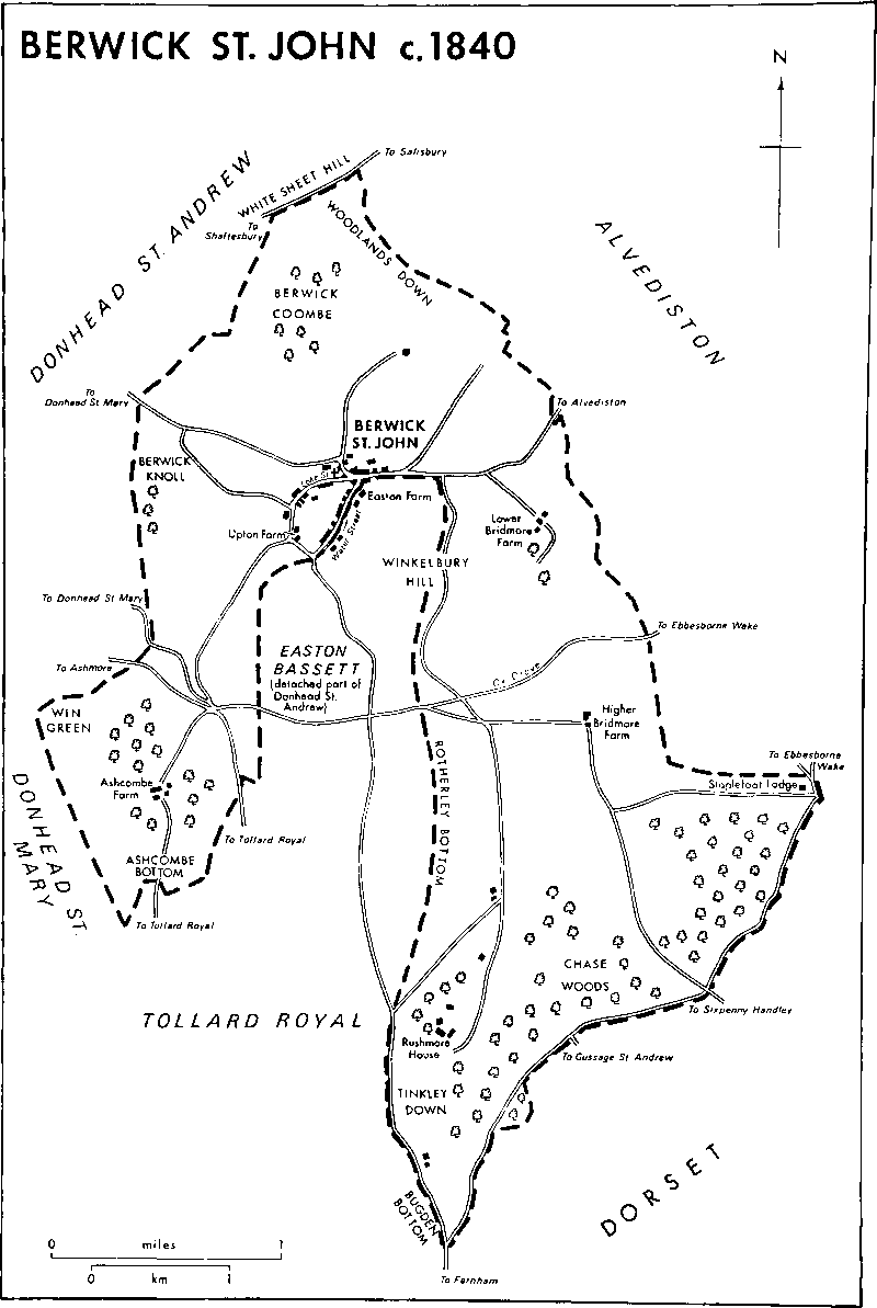
The ancient parish of Berwick St. John, 3,536 a. (1,430 ha.), (fn. 1) lay at the head of the Ebble valley 21 km. WSW. of Salisbury on Wiltshire's border with Dorset. It formed an inverted U; its short western arm extended 5 km. south from the top of White Sheet Hill, its broader eastern arm 7 km. between the hill and Bugden Bottom. (fn. 2) From the 10th century it was part of Wilton abbey's Chalke estate; (fn. 3) it had probably become a separate parish by the early 13th century, when it had a church. (fn. 4) By an order of 1884, perhaps not implemented until 1885, Easton Bassett, a detached part of Donhead St. Andrew parish lying between the two arms, was transferred to Berwick St. John. Thereafter the parish included 1,849 ha. (4,569 a.), (fn. 5) until 12 a. were transferred to Alvediston in 1986. (fn. 6) Most aspects of the history of Easton Bassett are treated with that of Donhead St. Andrew. (fn. 7)
The watershed of the Ebble and the Nadder extends south from White Sheet Hill across the western part of the parish. The east—west ridge which crosses both arms of the parish forms the watershed of the Ebble and the Tarrant. Much of the parish is chalk downland with characteristic
ridges and dry valleys. The steepest valleys are south facing coombs south of the east-west ridge, Rotherley Bottom, where the lowest land in the parish, below 107 m., lies, and Ashcombe Bottom. The highest point, at 277 m., is reached on Win Green at the parish's western corner. White Sheet Hill is over 229 m. and Winkelbury Hill, north of the southern watershed, over 260 m. Across the centre of the parish greensand outcrops and the land is flatter. (fn. 8) South of the church a stream rises; it flows northeastwards for only 400 m. before it disappears underground. Its valley, below 152 m., is the site of the village.
There is abundant evidence of prehistoric activity in the parish. Many sites in its south-east corner were excavated in the late 19th century by A. H. L.-F. Pitt-Rivers, owner of the Rushmore House estate and a pioneer of modern archaeological methods. (fn. 9) South Lodge Camp, 1 km. south of Rushmore House, is a square, late Bronze-Age enclosure. The site of an early Iron-Age settlement is 500 m. north of the house; Iron-Age pits and pottery of that and the Romano-British periods have been found in the same area. Winkelbury Camp on Winkelbury Hill is an early Iron-Age hill fort covering 5 ha., part of which lies outside the old parish boundary. A Belgic fort begun on the same site was unfinished. A PaganSaxon cemetery has been found 200 m. south of the camp. Prehistoric ditches cross the parish boundary at three points on White Sheet Hill. Another, 220 m. long, is on Woodlands Down, and others are near Rushmore House and on Winkelbury Hill. South of the hill a field system of 40 ha. lies across the old parish boundary. (fn. 10)
By the late 11th century the south-eastern boundary of Berwick St. John and that around Easton Bassett, which were boundaries of the Chalke estate, and perhaps the north-western boundary had been established. (fn. 11) The parish was presumably divided from the rest of the Chalke estate, east of it, in or before the early 13th century. (fn. 12) Much of the old parish boundary was marked by physical features, among them the stream on the north-west boundary of Easton Bassett, ridges on White Sheet Hill and at Win Green, and dry valleys including Rotherley Bottom and that east of Winkelbury Hill. (fn. 13) Ancient roads ran along the south-eastern boundary, also the county boundary, and along White Sheet Hill; (fn. 14) a ditch marks the eastern boundary on Woodlands Down.
In historical times the flatter ground east and west of the village was ploughed, and much of the downland and the steeper valleys was used for pasture. The southern parts of the parish have always been thickly wooded. (fn. 15) In 1968–9 Chase Woods, which extended beyond the parish boundaries and formed one of the largest areas of woodland of Cranborne Chase to survive, included c. 350 ha. in the south-east corner of Berwick St. John. Around Ashcombe Bottom there were c. 50 ha. of woodland. (fn. 16) In the late 16th century and the 17th there was a warren there. (fn. 17) Win Green, which lies partly in Berwick St. John parish and partly in Donhead St. Mary, was bought by the National Trust in 1937. (fn. 18)
Lords of Cranborne Chase claimed rights of chase and the administration of some forest laws in Berwick St. John as in neighbouring parishes. The whole parish lay within the chase's outer bounds; the inner bounds, although sometimes said not to have extended from Dorset into Wiltshire, (fn. 19) apparently included its south-east corner, where rights of chase were undisputed. There were, however, disputes concerning the lord of the chase's rights over the lands of Bridmore manor, which lay north and south of Ox Drove in the east part of the parish, and over those called Ashcombe in the south-west corner. In the late 16th century and the early 17th tenants of the demesne of Bridmore manor justified making fences and ditches to keep out deer by reference to a grant in 1302 of free warren to the lords of the manor. The owners of Ashcombe were also said in the early 17th century to have rights of free warren. (fn. 20) In the south-east part of the parish the area within the chase was divided between Staplefoot walk, which extended from the eastern corner of Berwick St. John into Alvediston and Ebbesborne Wake, and Rushmore walk, west and south of Staplefoot. (fn. 21) In Rushmore walk the keeper of the chase had a lodge, Rushmore Lodge, in the 15th century. (fn. 22) It was near the site of Rushmore House and from the 1690s was the administrative centre of the chase; courts for the chase were held there. (fn. 23) In Staplefoot walk West Lodge was replaced in the early 17th century by a new lodge, Staplefoot Lodge, (fn. 24) which may have been on the site of the Staplefoot Lodge built probably in the early 19th century (fn. 25) and demolished between 1926 and 1954. (fn. 26) The chase was disfranchised in 1829. (fn. 27)
White Sheet Hill and the Ebble—Tarrant watershed are followed, respectively, by north-east and south-west and east—west ridge ways. The western part of that on White Sheet Hill, which marked the parish boundary, was part of the road from Salisbury to Shaftesbury (Dors.), turnpiked in 1762. It became a track after 1788 when the Salisbury— Shaftesbury road north of the parish was turnpiked. (fn. 28) Ox Drove, which crossed the two southern arms of the parish, was in use in the 19th century (fn. 29) and in the late 20th had become a track east of Easton Bassett. Other ancient roads were that through Chase Woods marking the parish's south-east boundary and that from Donhead St. Mary through Berwick St. John village to the villages of the Ebble valley. (fn. 30) In the late 18th century the boundary road may have
Berwick St. John c. 1840
been only a track. (fn. 31) From the early 19th century the road from Donhead St. Mary was the main road through the parish. (fn. 32) The road leaving it near the western boundary to lead south-east to the southern part of Berwick St. John village via Upton Farm was in use in 1773. (fn. 33) The roads across the parish were linked by tracks running north and south. Of those in use in the 18th century (fn. 34) most were still visible in the late 20th but only those leading south from the village to Ox Drove and south from Ox Drove to the drive of Rushmore House were then metalled public roads. In the 17th century and the 18th tracks ran approximately north and south through Chase Woods. (fn. 35) In the mid or late 19th century drives, mostly straight and running both north-west and north-east, were made through the woods. (fn. 36)
When assessed for taxation in 1334 Berwick St. John was as prosperous as the average parish in Chalke hundred, (fn. 37) but in 1377 its total of 87 poll-tax payers was smaller than the average. (fn. 38) In the 16th century taxation assessments of Berwick St. John were low for the hundred. (fn. 39) In 1801 the population was 357; it had risen to 499 by 1861 but had fallen to 385 by 1881. (fn. 40) The decline was attributed to the migration of young men seeking employment. (fn. 41) The area transferred to Berwick St. John in 1884 or 1885 had a population of 41 in 1891 when 428 people lived in the enlarged parish. Thereafter the population fell, with occasional fluctuations; (fn. 42) it was 261 in 1981. (fn. 43)
The name 'Berwick' and the site beside a spring suggest that the village may be of Anglo-Saxon origin. The church, the rectory house, and Berwick St. John Manor, a house of 18th-century origin, stand on rising ground north-west of the stream. Easton Farm, built 200 m. south-east in Easton Bassett c. 1680, and Upton Farm, a 19th-century stone house 400 m. south-west of the church, occupy sites which may have been in use long before the surviving houses were built, (fn. 44) and farmsteads on those sites may have drawn settlement south and south-west. From the late 18th century the focus of the village was the junction of the Donhead St. Mary road and two lanes, (fn. 45) Loke Street, so called in 1926 (fn. 46) but earlier called Duck Street, (fn. 47) leading west, and Water Street leading south. The stream flows along the east side of Water Street. Buildings east of the stream and south of the east part of the Donhead St. Mary road were part of the village but lay within Donhead St. Andrew parish until 1884 or 1885. (fn. 48) Dairy House Farm was built in Loke Street in the late 17th century, and by the late 18th century there were buildings beside most of Loke Street and Water Street. (fn. 49) The extent of the village changed little be tween then and 1984 but few buildings of the 18th century or earlier survive. Many cottages were rebuilt in the early 20th century. (fn. 50) The village was designated a conservation area in 1975. (fn. 51)
The oldest surviving buildings beside the Donhead St. Mary road are two rows of 18th-century cottages, one east and one north of the junction with Loke Street and Water Street. Early 19th-century buildings include, at the junction, a school and farm buildings and, north of them, a pair of thatched cottages. An inn east of the junction was called the Grove Arms in 1855 but from 1903 was known as the Talbot. (fn. 52) Cottages, including estate cottages, were built north and east of the inn in the 1890s and the early 20th century. At the east end of the village is the Priory, a large stone house apparently of the late 19th century but occupying the site and perhaps incorporating part of an older building. (fn. 53) In the 20th century houses were built east and west of Woodlands Lane and on scattered sites east of the village.
In addition to Upton Farm and Dairy House Farm there was apparently a third farmstead in Loke Street, south of Dairy House Farm, in 1773. (fn. 54) It was greatly extended in the late 20th century and little of the old building survives. The 19th-century buildings in Loke Street include a large house near the junction with the Donhead St. Mary road, a nonconformist chapel, and the Terrace, four small stone cottages built in the form of a crescent. In the late 20th century several private houses and bungalows and several council houses have been built beside the street.
On either side of Water Street are stone and brick cottages, some of which are thatched and most of which are 19th-century. On the higher ground west of the street are Curfew Cottage, the successor to a cottage given in the 18th century to endow the ringing of a curfew, (fn. 55) and Water House, a stone house much extended in the 20th century. There has been little building beside the street in the 20th century, but bungalows have been built at its northern and southern ends.
No settlement outside the village can be identified from documentary evidence before the 15th century when Rushmore Lodge was in use. (fn. 56) Either Lower Bridmore Farm, a small, stone, early 18th-century house, or Higher Bridmore Farm, a slightly later brick and stone house, may have succeeded an earlier demesne farmhouse of Bridmore manor. (fn. 57) A track which linked the two farmsteads in the late 18th century and in 1886 (fn. 58) had disappeared south of Ox Drove by 1900. (fn. 59) There was a house and farmstead in Ashcombe Bottom in the late 17th century; Ashcombe House stands at or near its site. (fn. 60) A build ing which stood on the site of Woodlands in 1773 (fn. 61) was probably a house rebuilt or improved in the 1840s when grounds west and south of it may have been landscaped. A new stone house was built in 1935. (fn. 62) In the late 19th century a lake in the grounds of Ferne House in Donhead St. Andrew lay on the parish boundary west of Berwick St. John village. It was drained and houses were built south-east of it in the early 20th century. (fn. 63)
Manors and other Estates.
Much, if not all, of Berwick St. John parish lay within the estate of Chalke granted by King Edwy to the nuns of Wilton in 955. An estate of 6 hides, not included in that grant but apparently held by the nuns in the late 11th century, may have been within the parish, perhaps comprising the north-west part; (fn. 64) it cannot, however, be identified with any later holding in Berwick St. John. All the land in the parish was held of Wilton abbey in the later Middle Ages. (fn. 65)
BERWICK ST. JOHN manor was a distinct estate of the abbey in the early 13th century. (fn. 66) It passed to the Crown at the Dissolution, and in 1541 was granted to George Howard. (fn. 67) In 1547 Howard sold the manor to Sir William Herbert (fn. 68) (cr. earl of Pembroke in 1551, d. 1570). Pembroke was succeeded in turn by his son Henry, earl of Pembroke (d. 1601), and by Henry's son William, earl of Pembroke, (fn. 69) who in 1608 sold the manor to Robert Cecil, earl of Salisbury (fn. 70) (d. 1612). It passed in turn to Cecil's son William, earl of Salisbury (d. 1668), and William's grandson, James Cecil, earl of Salisbury, (fn. 71) who sold it in 1671 to Anthony Ashley Cooper, Baron Ashley (fn. 72) (cr. earl of Shaftesbury in 1672, d. 1683). It passed from father to son with the earldom to Anthony (d. 1699), Anthony (d. 1713), Anthony (d. 1771), and a fifth Anthony, (fn. 73) who sold the manor in two parts in 1792.
The lordship, the land held by copy, and c. 750 a. of woodland in the south-east were bought by George Pitt, Baron Rivers (d. 1803). (fn. 74) They passed to his son George, Baron Rivers (d. 1828), whose nephew William Beckford inherited the estate and title and took the surname Pitt-Rivers. William (d. 1831) was succeeded by his son George, Baron Rivers (d. 1866), and in turn by George's son Henry, Baron Rivers (d. 1867), and brother Horace PittRivers, Baron Rivers (d. 1880). (fn. 75) Under the will of George, Baron Rivers (d. 1828), the estate passed in 1880 to a great-grandson of George, Baron Rivers (d. 1803), A. H. Lane-Fox, the archaeologist and anthropologist, who took the additional surname Pitt-Rivers, by which he was afterwards generally known. After Pitt-Rivers's death in 1900 the estate passed in the direct male line to his son A. E. L.-F. Pitt-Rivers (d. 1927), (fn. 76) grandson G. H. L.-F. PittRivers (d. 1966), (fn. 77) and great-grandson Mr. M. A. Pitt-Rivers, the owner in 1984. (fn. 78)
The demesne of the manor, a farmstead and 450 a., was sold in 1792 to the tenant Henry Foot (fn. 79) (d. 1820). (fn. 80) The farm was held in 1830 by his relict, (fn. 81) and by Charles Foot, perhaps their son, in 1839. (fn. 82) Foot sold the farm, later Manor farm, c. 1842 to Thomas Grove (d. 1847) of Ferne House. (fn. 83) The farm, then known as Church farm, was sold c. 1901 by Sir Walter Grove, Bt., with Ferne House to A. H. Charlesworth (fn. 84) (d. 1914), whose executors sold the Ferne House estate in 1915 to Alfred Douglas-Hamilton, duke of Hamilton and Brandon. (fn. 85) In 1935 the duke sold Church, later Manor, farm to M. Dineley, who was succeeded by his son Mr. F. Dineley, the owner in 1984. (fn. 86)
In the early 14th century Robert of Rushmore held ½ yardland called RUSHMORE and the office of woodward freely of Wilton abbey. The land and office had passed to Robert Solyman or Saleman by 1354, and to his son John by 1374. Another Robert Solyman held them in 1413. (fn. 87) The land was probably that held with the lordship of Cranborne Chase. The Crown was lord of the chase from the mid 15th century, (fn. 88) and in 1616 sold the lordship to William Cecil, earl of Salisbury. It passed with Berwick St. John manor to Anthony, earl of Shaftesbury, who sold it in 1692 to Thomas Freke. (fn. 89) By will proved 1702 Freke devised the lordship to his kinsman Thomas Pile and Pile's daughter Elizabeth, wife of another Thomas Freke, to be held jointly, with reversion to the testator's nephew George Pitt, who inherited it on Elizabeth's death in 1714 or 1715. (fn. 90) George (d. 1734) was succeeded in turn by his son George (d. 1745) and by George's son George (cr. Baron Rivers in 1776, d. 1803). (fn. 91) From 1792 the chase passed with the lordship of Berwick St. John manor. (fn. 92) In 1829 rights of chase within the parish were replaced by an allotment of 250 a.; (fn. 93) with Rushmore, c. 25 a., (fn. 94) that land passed in the PittRivers family to Mr. M. A. Pitt-Rivers. (fn. 95) In 1966 Rushmore House and 57 a. were sold to Sandroyd School; the remaining land was owned by Mr. Pitt-Rivers in 1984. (fn. 96)
Rushmore Lodge, standing in the 15th century, (fn. 97) was repaired in 1546 (fn. 98) and replaced in the early 17th century. Part of the 17th-century lodge was demolished and the remainder used as offices from the mid 18th century, when Rushmore House was built nearby. The house, of c. 1760, (fn. 99) was perhaps the central part of the ashlar-faced main block of that standing in 1984. (fn. 100) In the early 19th century a southern extension was built with, to the south, a pair of two-storeyed canted bay windows and between them a front of three bays. Similar windows were later added on the east and west sides of the extension, and a northern wing of the house was replaced by a service range. The interior was much altered for A. H. L.-F. Pitt-Rivers after 1880. Philip Webb was consulted about some of the alterations (fn. 101) and the decoration is reputed to have been by Morris & Co. (fn. 102)
Lands around the lodge, presumably including Rushmore, were imparked in the early 17th century. (fn. 103) In the 19th and 20th centuries no clear boundary existed between the park and the surrounding woods. (fn. 104) Apart from Rushmore House there were few buildings in the park in the late 18th century. (fn. 105) Park House was built in the early 19th century, and in 1839 there were cottages 500 m. north of it. (fn. 106) New gardens around Rushmore House were planned after 1856. (fn. 107) It is not clear whether those plans took effect, and in the 1880s and 1890s many changes were made to the grounds. (fn. 108) The straight drives through the park and Chase Woods were probably made at that time, (fn. 109) and cottages north of Rushmore House and lodges in 16th-century style at the northern, north-eastern, and southern park gates were built. (fn. 110) A small chapel in similar secular style was built west of the northern gate in 1887. (fn. 111) The principal, northern, gate and perhaps some buildings were designed by Webb. (fn. 112) Kitchen gardens had by the mid 1880s been laid out 500 m. south-east of the house. Then or later they were enclosed by a high red-brick wall; (fn. 113) circular turrets with conical roofs stood at three corners and a viewing platform, looking south-east, at the fourth.
From 1893 A. H. L.-F. Pitt-Rivers maintained a menagerie within the park, (fn. 114) chiefly in paddocks near North Lodge. (fn. 115) Attempts to acclimatize foreign animals and birds, including reindeer and white peacocks, were largely unsuccessful, but experimental breeding produced unusual crosses, for example of yaks and indigenous domestic cattle. Like the Larmer Grounds in Tollard Royal the menagerie was open to the public. (fn. 116)
BRIDMORE was named as an estate of Wilton abbey in 1225, (fn. 117) and was then and afterwards held of the abbey at fee farm. Fee-farm rents from Bridmore manor, formerly paid to the abbey, were granted in 1544 to William Herbert (cr. earl of Pembroke in 1551); (fn. 118) the grant was confirmed in 1551. (fn. 119) The rents were paid to lords of Berwick St. John manor until 1672; the manors were afterwards held together and the rents were presumably extinguished. (fn. 120)
Bridmore manor was held by Alfred of Bridmore in 1225 (fn. 121) and by Geoffrey of Bridmore in 1242–3. (fn. 122) Geoffrey conveyed it in 1256 to Walter Marsh and his wife Edith; if Edith died without issue by Walter it was to revert to Geoffrey. (fn. 123) In 1302 John of Berwick was granted free warren in his demesne at Bridmore. (fn. 124) He apparently conveyed the manor to Sir John Hussey, probably his nephew, who received a similar grant of free warren in 1303. (fn. 125) Hussey (d. in or before 1312) (fn. 126) was succeeded in turn by his sons Sir Roger (cr. Lord Hussey in 1348, d. 1361) (fn. 127) and John (d. 1370). (fn. 128) Bridmore was sold, probably by that John's son John, in 1379 to Sir Thomas West (fn. 129) (d. 1386). West was succeeded in turn by his son Sir Thomas (fn. 130) (cr. Lord West in 1402, d. 1405) (fn. 131) and by that Sir Thomas's son Reynold (fn. 132) who became Lord West in 1416 and Lord la Warre in 1427. The manor passed from Reynold (d. 1450) with the la Warre title to his son Richard (d. 1476), to Richard's son Thomas (d. 1525), and to Thomas's son Thomas, (fn. 133) who sold it, apparently to Richard Kyrton, in 1531. (fn. 134) Kyrton immediately gave it by exchange to Sir William Uvedale (d. 1542). (fn. 135) Bridmore was inherited in turn by Sir William's son Henry (d. 1599) (fn. 136) and by Henry's son Sir Edmund, who settled it in 1608 on his brother George. (fn. 137) On George's death in 1629 the manor passed to his grandson Edmund Okeden. (fn. 138) Edmund was succeeded between 1647 (fn. 139) and 1656 by his son William, (fn. 140) who sold Bridmore in 1672 to Anthony, earl of Shaftesbury. (fn. 141) It passed with Berwick St. John manor (fn. 142) until 1792 when it was sold in three parts. Higher Bridmore farm, c. 420 a., was bought by John Phelps (fn. 143) and sold by him c. 1802 to George, Baron Rivers. (fn. 144) It passed with Rivers's other estates in Berwick St. John to Mr. M. A. Pitt-Rivers. (fn. 145) Some 50 a., formerly part of Higher Bridmore farm, were sold to Lord Rivers in 1792 and reunited with the farm c. 1802. Lower Bridmore farm, c. 400 a., was bought in 1792 by Thomas Grove (fn. 146) (d. 1847). It passed as part of the Feme House estate to his son John (d. 1858), and in turn to John's son Thomas (cr. a baronet in 1874, d. 1897), and Sir Thomas's son Sir Walter, (fn. 147) who sold most of the estate c. 1901. (fn. 148) Lower Bridmore farm passed with Manor or Church farm to A. H. Charlesworth and to Alfred, duke of Hamilton and Brandon, who sold it in or before 1920 to E. H. James. (fn. 149) It was bought from James or another c. 1935 by M. Dineley and passed with Manor farm to Mr. F. Dineley, the owner in 1984. (fn. 150)
Lands 'in Bridmore' were conveyed by Roger of Trow to William of Gurston and his wife Amice in 1241. (fn. 151) The lands may have been those which, as part of one of the manors in Alvediston called Trow, were held with Norrington manor in Alvediston from the 16th century. (fn. 152) In 1791 James Arundell held c. 70 a. in Berwick St. John as part of Norrington manor; (fn. 153) 55 a. were transferred to William, Baron Rivers, at the disfranchisement of Cranborne Chase in 1829. (fn. 154).
The manor later called UPTON LUCY was held of Wilton abbey in 1242–3 (fn. 155) and at the Dissolution. (fn. 156) In 1544 the overlordship was granted to Sir William Herbert, (fn. 157) and thereafter it passed with Berwick St. John manor. (fn. 158)
Richard son of Richard held an estate called Upton in 1242–3. (fn. 159) It may have been that conveyed by John son of Richard of Upton to Robert de Lucy in 1277; (fn. 160) in 1281 it was presumably that said to be held by Philip of Upton's heirs. (fn. 161) Members of the Upton family retained an estate called Upton, which was settled on Roger of Upton and his wife Joan with remainder to their son John in 1318, (fn. 162) but its later history has not been traced. Robert de Lucy held Upton lands in 1260 (fn. 163) and was succeeded c. 1262 by his son Robert, (fn. 164) perhaps the grantee of 1277. Lands formerly belonging to the Lucy family are said to have passed in the FitzHerbert family to Alice FitzHerbert, wife of Sir Thomas West (d. 1386). (fn. 165) Upton Lucy manor was settled on Alice and Thomas in 1381. (fn. 166) It passed with Bridmore manor to Thomas, Lord West and la Warre, (fn. 167) who in 1517 settled estates, probably including Upton, on trustees for his son Thomas. (fn. 168) The younger Thomas became Lord West and la Warre in 1525, and died in 1554; (fn. 169) thereafter the manor passed, presumably by sale, to William Horsey who held it in 1558. (fn. 170) In 1563 it was settled on William Horsey, possibly the same, and his wife Dorothy. (fn. 171) That William died c. 1570; (fn. 172) Dorothy (fl.1576) (fn. 173) was succeeded in or before 1578 by Bartholomew Horsey. (fn. 174) On Bartholomew's death in 1596 (fn. 175) his relict Frances (fl. 1616) retained Upton for life. (fn. 176) His son Thomas in 1603 conveyed the reversion to John Butler. (fn. 177) A John Butler held the manor in 1643, as did Henry Butler in 1646. (fn. 178) Henry sold the demesne in two parts, Upton farm, bought by Thomas Grove in 1658, (fn. 179) and Ashcombe, c. 140 a., bought by Robert Barber in or before 1665. (fn. 180) In 1693 Sir Henry Butler, perhaps Henry's son, sold the rest of the manor to Grove's son Robert (fn. 181) (d. 1695). With Upton farm it was inherited in turn by Robert's son Thomas (d. 1739), Thomas's sons Thomas (d. 1750) and John (d. 1769) (fn. 182) and John's son Thomas. (fn. 183) From 1792 the estate passed with Lower Bridmore farm. (fn. 184) In 1920 Alfred, duke of Hamilton and Brandon, sold Upton farm to Walter Arnold. In 1932 Arnold sold the farm, 180 a., to H. G. Walby. In 1959 Walby bought another 47 a., formerly part of the Feme House estate, and transferred the whole farm to his son Mr. R. S. Walby, who owned it in 1984. (fn. 185)
ASHCOMBE passed from Robert Barber (d. 1686) in turn to his son Robert (d. 1740) and to the younger Robert's daughter Anne, (fn. 186) wife of John Wyndham (d. 1750). By 1780 Anne had been succeeded by her daughter Anne (d. 1796), wife of James Arundell (d. 1803). (fn. 187) The Arundells' son James, who became Baron Arundell of Wardour in 1808, (fn. 188) sold Ashcombe in 1815 to Thomas Grove. (fn. 189) As part of the Feme House estate it passed to Alfred, duke of Hamilton and Brandon. (fn. 190) He sold it in 1916 to R. W. Borley, whose son Mr. H. Borley was the owner in 1984. (fn. 191)
There was a substantial house at Ashcombe in the early 17th century. (fn. 192) In the 18th century it was enlarged or rebuilt, with a principal south front of six bays and a west wing. North of the house was a large stable block and east of it a smaller house and ornamental gardens. (fn. 193) The main house was demolished in the early 19th century. (fn. 194) The smaller house and part of the stable block were standing c. 1930 and were restored soon afterwards by (Sir) Cecil Beaton, the photographer and designer. (fn. 195)
In 1382 lands said to be in Upton, perhaps derived from the Lucys' 13th-century estate, were settled on Sir William de Lucy with remainder to Henry Bartour. (fn. 196) The lands may have been those called LUCY'S held with Easton Bassett manor by Reynold, Lord West and la Warre (d. 1450). (fn. 197) They passed with Bridmore manor to Thomas, Lord West and la Warre (d. 1554), (fn. 198) who sold them in 1537 to Sir William Shelley. (fn. 199) Thereafter they passed with Easton Bassett manor, mainly in the Shelley family until 1773, with the earldoms of Pembroke and Montgomery until 1850, and afterwards in the Grove family. (fn. 200) Sir Walter Grove, Bt., sold Easton farm, including lands derived from Lucy's, in 1920 to William Follett. (fn. 201) After Follett's death in 1931 it was held jointly by his children, Horace, William, and Edith, and in 1964 it was divided into Easton and Chapel farms, held respectively by Horace's sons Mr. Norman Follett and Mr. Bryan Follett in 1984. (fn. 202)
Members of the Coty family may have held lands in Berwick St. John in 1281–2. (fn. 203) In 1318 John Coty conveyed lands there to John Francis and his wife Margery. (fn. 204) COTY'S was held by Thomas, Lord West and la Warre, in 1535 (fn. 205) and was thereafter merged with Lucy's. (fn. 206)
Economic History.
In the 16th century, as presumably earlier, the open fields and common pastures of Berwick St. John, Bridmore, and Upton Lucy manors were separate. (fn. 207) Those of Berwick St. John, c. 850 a., lay north and west of the village; there was also pasture in the woodland, c. 800 a., in the parish's south-eastern corner. The fields and pastures of Bridmore, c. 850 a., lay north of the woodland in the parish's eastern arm, and those of Upton Lucy, c. 800 a., lay in the southern part of the western arm. (fn. 208)
In 1225 there were 25 tenants of Berwick St. John manor; their stock included 736 sheep, 58 draught beasts, and 33 cows. Flocks each of 100 sheep or more belonged to four tenants. The largest number of animals, including 178 sheep and 16 oxen, belonged to Nicholas of Wiltshire, perhaps tenant of the demesne. (fn. 209) In 1208 he held 5 hides in Berwick St. John, presumably as tenant of Wilton abbey. (fn. 210) Lessees of the demesne were again recorded from the early 16th century. (fn. 211) In the mid 16th century the farmer and the customary tenants worked six fields; a seventh, West field, was worked only by tenants. Farmer and tenants shared 200 a. of pasture on Woodlands Down and 60 a. in Berwick Coombe; the tenants used part of the down from 1 August to 2 February and shared the coomb with the farmer from 24 June to 25 December. The tenants also had common pasture on Berwick Knoll, 40 a., on 10 a. near Tinkley Coppice, and on 2 a. near Parsonage Coppice, and kept draught animals on Tinkley Down. They had the right to graze cattle in Old Hewett or Costard's Coppice, 30 a.; (fn. 212) in 1626 the right extended to all coppices of more than seven years' growth in the lord's woods. (fn. 213) The arable of the estates called Coty's and Lucy's was in the fields of Berwick St. John (fn. 214) but their feeding rights were in the pastures of Upton manor. (fn. 215) In 1567 the demesne farm of Berwick St. John manor included 240 a. of arable, 17 a. of meadow, 57 a. of several pasture, and common pasture for 400 sheep. Seven copyholders, holding a total of 7 yardlands, had pasture for 760 sheep, and 148 a. of arable, of which 19 a. lay in the fields of Bridmore manor and 16 a. had recently been inclosed. There were 75 a. of Coty's and Lucy's in the open fields. A copyhold of 1½ yardland was held by the farmer of the demesne (fn. 216) and may have been merged with the demesne by 1636, when six copyholders had 115 a. of arable. (fn. 217) In the mid 18th century there were 154 a. of demesne arable in the open fields and 86 a. in severalty. The rector and the occupiers of 'small livings', presumably copyholds and former copyholds, had a flock of 800 sheep. (fn. 218)
On Bridmore manor in 1225 livestock and grain on the demesne accounted for almost half the total value of stock and grain and included 200 sheep, 18 oxen, and 12 cows. There were 15 tenants, presumably customary tenants, who had 454 sheep; most had 20–40 each. (fn. 219) Rents totalling 405. were paid by free and customary tenants in 1361. (fn. 220) In 1380 there were 76 a. of sown arable and 160 sheep on the demesne. (fn. 221) Bridmore, Lake, Middle, and Pincombe fields were worked by the lessee of the demesne and other tenants of Bridmore manor in the late 16th century. A customary tenant of Berwick St. John manor also held land in three of the fields. The common pastures of Bridmore manor lay on the downs north and south of Ox Drove. (fn. 222) The demesne was probably leased in the early 16th century. (fn. 223) Robert Toppe, lessee in 1549, (fn. 224) was succeeded in turn by Thomas Toppe (will proved 1598), Thomas's son Robert (fi. 1613), and Robert's son Francis (fl. 1630). (fn. 225) The demesne farm included a flock of c. 800 sheep in 1516, (fn. 226) and 60 a. of several arable in the late 16th century. (fn. 227) There may have been copyholders of the manor in the mid 16th century (fn. 228) but none is mentioned thereafter. The lands of the manor were divided into two farms, probably in the early 18th century when new farmhouses were built; Higher Bridmore and Lower Bridmore farms were divided roughly by Ox Drove. (fn. 229)
The demesne of Upton Lucy manor was perhaps 1 carucate and 40 a. of wood in 1386. (fn. 230) In the late 16th century common pasture for the lord and tenants was on the hills around Ashcombe Bottom. (fn. 231) Grazing there for 160 sheep belonged to Coty's and Lucy's. (fn. 232) The demesne had by then been divided between Ashcombe and Upton farms; (fn. 233) the farms were leased separately in the 17th century. (fn. 234) Ashcombe farm comprised 140 a. of woodland and a warren, part of which was ploughed in the early 17th century. (fn. 235) The surviving warren may have been able to support 300 couples of rabbits in 1661. (fn. 236) There were three copyholders in the early 17th century. (fn. 237) In the early 18th century, and probably earlier, the copyholders worked arable in the fields of both Upton Lucy and Berwick St. John. (fn. 238) By 1761 their holdings had become a single farm of 100 a., mostly several, with pasture for 25 sheep; thereafter it was leased with Upton farm. (fn. 239)
In 1791 the parish was a third arable, a third pasture, and a third woodland. There was little meadow land. Higher Bridmore, 478 a., Lower Bridmore, 424 a., Berwick, later Manor or Church, 450 a., and Upton, 403 a., were the largest farms. Farms of 102 a., perhaps still copyhold of Berwick St. John manor, and 156 a., part of Coty's and Lucy's, were held together. The remainder of Coty's and Lucy's, 173 a., was perhaps worked with Easton farm in Easton Bassett. The lands of Ashcombe were divided between a farm of 167 a. and the woods, c. 80 a., which were held separately. Other holdings of fewer than 100 a. included the rectorial glebe and the Rushmore House estate. The whole parish was apparently held in severalty. The larger portion of Coty's and Lucy's included 126 a. recently inclosed. (fn. 240) An award of 1,699 a., made in 1794 under an Act of 1786, may have confirmed other recent inclosures. Allotments were made of 426 a. for Berwick farm, 114 a. for the smaller part of Coty's and Lucy's, and 84 a. for the lands held with that part. The largest allotment was of 759 a. of Chase Woods. (fn. 241) Between 1791 and 1839 land use changed little but most farms of fewer than 100 a. were absorbed into larger farms. (fn. 242)
In the late 19th century the land north of Ox Drove and that of Ashcombe farm was part of the Feme House estate; the rest of the parish lay within the Rushmore House estate. (fn. 243) In 1901 the Ferne House estate included seven farms with lands in the enlarged parish of Berwick St. John; (fn. 244) most were chiefly sheep farms. (fn. 245) Church farm, 587 a., Easton farm, 367 a., Upton farm, 131 a., and three smaller farms, Foot's, Dairy, and Rose, were worked from farmsteads in the village. There were racing stables at Church Farm. On Lower Bridmore farm, 444 a. including 75 a. of wood, a dairy herd was kept. There were 800 a. of woodland and rough pasture, of which c. 400 a. around Ashcombe House was the only part of the estate within the parish not leased. (fn. 246) By 1910 the three smaller farms had been merged as Cross farm. Church farm was then worked by the owner. (fn. 247)
After 1916 Ashcombe farm, c. 500 a., was managed with lands in Tollard Royal, Donhead St. Mary, and Ashmore (Dors.) as a mixed farm. (fn. 248) From the 1930s Upton farm, c. 200 a., and Easton farm, c. 600 a., were worked by the owners. Tenants held Cross farm, 180 a., Lower Bridmore farm, 400 a., and Manor farm, 400 a. Most were dairy farms in the 1930s. Upton was still a dairy farm in 1984 but much of the land of the other farms was then arable. (fn. 249)
In the 19th century lands held with Rushmore House, sometimes called Rushmore farm, and Chase Woods were in hand. (fn. 250) Higher Bridmore farm, also part of the Rushmore House estate, was leased. (fn. 251) In 1848 Higher Bridmore farm included c. 500 a., Rushmore farm 350 a. (fn. 252) After 1880 c. 130 a. around Rushmore House became parkland. The remainder of Rushmore farm was added to Higher Bridmore farm, which measured 794 a. in 1910. (fn. 253)
In the 16th century Bridmore manor probably included 300 a. or more of woodland, and Upton Lucy 100–150 a. The woods of Berwick St. John manor covered c. 450 a. in 1567; oak and ash grew, and 38 a. of coppice had been cleared. (fn. 254) The coppices within Rushmore walk of Cranborne Chase were leased in the early 17th century. (fn. 255) Lands around Rushmore Lodge had been inclosed by 1567; (fn. 256) in the early 17th century there was a park of c. 25 a. The lord of the chase, then also lord of Berwick St. John manor, promised a buck and a doe yearly to tenants of the manor to compensate for their lost grazing rights. The promise was not kept until a new agreement on the same terms was reached in 1669. (fn. 257) In the early 18th century woods south of Higher Bridmore farm, which had been part of Bridmore manor, were held with those of Berwick St. John manor. (fn. 258) The woodland, 1,081 a. in the enlarged parish in 1910, (fn. 259) was traditionally managed in the late 20th century. Until 1970 coppice wood for making hurdles was sold at annual auctions. In 1980 there were 800 a. of hazel, and beech and Norway spruce were also grown. (fn. 260)
The right to hold a weekly market was granted to the lord of Bridmore manor in 1303. (fn. 261) There was a mill at Berwick St. John in 1502. (fn. 262) No other record of either market or mill has been found.
William Monk, a clockmaker, worked in Berwick St. John between 1718 (fn. 263) and 1748. (fn. 264) He made clocks for Broad Chalke church and Sherborne abbey (Dors.). (fn. 265)
Local Government.
A tithingman of Berwick St. John who attended courts for Chalke hundred in 1502 and later in the 16th century apparently represented the whole parish. (fn. 266)
Courts baron for Berwick St. John manor were recorded in the 16th and 17th centuries. They were usually held in spring and autumn, but in the 1640s were not held every year. The homage presented absentees from the court, vacant copyholds, and the need for repairs to fences, buildings, wells, and the watercourse beside Water Street. Breaches of manorial custom were also presented; in 1643 they included keeping more than the permitted number of ducks on the stream and of geese in the fields. (fn. 267) In 1669 the dispute between tenants of the manor and the lord of Cranborne Chase over compensation for lost grazing rights around Rushmore Lodge was ended by an agreement reached in the court. (fn. 268)
Courts for Upton manor, held every few years between 1744 and 1790, dealt only with tenurial matters. (fn. 269)
Between 1662 and 1688 the parish's average annual expenditure on the poor was £27. (fn. 270) In the late 18th century and the early 19th expenditure generally followed the same pattern as in other parishes in the hundred. It rose from £83 in 1775–6 to £218 in 1802–3, when regular payments were made to 22 adults and 32 people received occasional relief. There were regular payments to 35 adults in 1812–13 when £713 was spent. Expenditure had declined to £325 by 1814–15 (fn. 271) and thereafter fluctuated. (fn. 272) Between 1830 and 1834 it fell from £406 to £186. (fn. 273) The decline may be partly attributable to the adoption by the vestry of the roundsman system in 1833. (fn. 274) Berwick St. John became part of Tisbury poor-law union in 1835 (fn. 275) and of Salisbury district in 1974. (fn. 276)
Church.
There was a church at Berwick St. John in or before the early 13th century. (fn. 277) Wilton abbey was licensed to appropriate the rectory in 1334 (fn. 278) but no appropriation took place. The abbey presented to the living in 1305 and at most vacancies before the Dissolution; (fn. 279) perhaps in 1315 and certainly in 1385 Shaftesbury abbey was patron, (fn. 280) by what right is not known. The advowson passed with Berwick St. John manor to William Herbert, earl of Pembroke (d. 1570), (fn. 281) and thereafter with the Pembroke title. In 1579 William Pinkney presented by grant from an earl of Pembroke. (fn. 282) Henry Sandys, patron in 1635, (fn. 283) had probably received a similar grant. In 1683 the advowson was sold by Philip, earl of Pembroke and Montgomery, to a trustee of John Gane, rector of Berwick St. John 1674–1738. In 1734 Gane's trustees conveyed it to his nephew John Gane. (fn. 284) The nephew John was presented to the rectory in 1738 by Thomas Grove, either as trustee or by grant of a turn. (fn. 285) In 1741 Gane sold the advowson to New College, Oxford. (fn. 286) In 1929 it was bought from the college by Reginald, earl of Pembroke and Montgomery (fn. 287) (d. 1960), whose son Sidney, earl of Pembroke and Montgomery, transferred it in 1962 to the Salisbury diocesan patronage board. (fn. 288) Berwick St. John rectory was held in plurality with Alvediston vicarage in 1945–6 and from 1947 to 1955, and with Donhead St. Andrew rectory from 1955 to c. 1979. (fn. 289) In 1981 it became part of the new benefice of Chalke Valley West, to which the diocesan patronage board was entitled to present at every third turn. (fn. 290)
In 1291 the rectory, valued at £20, was one of the richest livings in Chalke deanery. (fn. 291) Its value remained well above the average. In 1535 the rector received £26 11s. 7d, (fn. 292) and between 1829 and 1831 his average yearly income was £562. (fn. 293)
From the late 16th century or earlier no tithe was paid for 100 sheep pastured on the demesne of Berwick St. John manor. (fn. 294) In 1783 the rector received half a buck a year from the lord of Cranborne Chase in place of tithes from all or part of Rushmore park. (fn. 295) In 1839 the remaining tithes of the parish were valued at £518 and commuted. (fn. 296)
In the early 13th century the rector acquired, by purchase or gift, 10 a. of woodland, which lay with that of Bridmore manor, and 32 a. of arable. (fn. 297) In 1588 most of the rector's arable lay in the fields of Berwick St. John manor but there were 7½ a. in those of Bridmore. He was said to have pasture for 50 sheep with the flocks of Berwick St. John and for 160 sheep with those of Bridmore; figures for the two manors should probably be reversed. In exchange for wood tithes he had received 20 a. of woodland, probably Parsonage and Staplefoot Coppices. (fn. 298) In 1783 there were 50 a. of arable and meadow, including land near the rectory house for which grazing rights on the pastures of Berwick St. John manor had been exchanged; there remained pasture for no sheep. (fn. 299) An allotment of 64 a. made at inclosure in 1794 (fn. 300) was probably of c. 30 a. in Chase Woods, including Parsonage and Staplefoot Coppices, and c. 30 a. of arable. Hanging Ridge Coppice, 8 a., was granted to the rector in exchange for wood tithes c. 1805. (fn. 301) In 1829 he conveyed 19 a. of woodland to William Pitt-Rivers, Baron Rivers, under the agreement for disfranchising Cranborne Chase. (fn. 302) In 1839 the rector held 55 a.; (fn. 303) the land was sold in 1930. (fn. 304)
There was a rectory house, said to need extensive repairs, in 1674. (fn. 305) It was perhaps the two-storeyed stone house in which the rector lived in 1783. (fn. 306) A new stone house was built in 1798 (fn. 307) and enlarged in 1880. (fn. 308) It was sold in 1950. (fn. 309)
In 1315 Peter of Lyme was deprived of the rectory because he had not been ordained priest within a year of admission. (fn. 310) His successor, John of Tarrant, was an official of Salisbury diocese, (fn. 311) and other well qualified and usually pluralist clergy were rectors in the Middle Ages. John Halewell, rector from 1385, was in 1397 licensed to be absent for a year; (fn. 312) Edmund Audley, rector from 1465, was also archdeacon of the East Riding of Yorkshire. (fn. 313) In 1584 the cure was served by a reader who preached, perhaps without a licence, and by the rector, Robert Pinkney, who was accused of hunting, playing bowls, and causing quarrels among his parishioners. In 1585 Pinkney was presented for not catechizing or wearing a surplice, but church services were said to be more orderly than they had been. (fn. 314) Compton South, rector from 1657, refused to use the Book of Common Prayer when it was reintroduced, causing the churchwardens to call on neighbouring clergy to bury and baptize in the parish. (fn. 315) His teachings, for example on the sacraments, were unacceptable in the Church of England and there were disturbances when he offered his pulpit to preachers who shared his views. South was deprived in 1662; the church was then in need of repair and inadequately furnished. (fn. 316) His successor, John Priaulx, was archdeacon of Salisbury; Priaulx's son served Berwick St. John as curate. (fn. 317) In the mid and late 18th century communion was celebrated six times a year; there were between 20 and 30 communicants. Morning and afternoon services were held on Sundays and additional services on holy days after Christmas, Easter, and Whitsun, and on Good Friday. (fn. 318) In 1864 communion was celebrated at the principal festivals and monthly, and a second celebration each month was to be introduced; c. 20 communicants received at each celebration. There were services on Wednesdays and Fridays, as well as two each Sunday. (fn. 319)
In 1341 the rector was said to hold a chapel, presumably that at Easton Bassett: it is unlikely that he did so. (fn. 320) There was a fraternity, known as the brotherhood of Our Lady, in the parish in 1526; its later history is not known. (fn. 321)
The church, called ST. JOHN'S in 1255 (fn. 322) and St. John the Baptist's in the early 19th century, (fn. 323) was built in the 13th century or earlier. In the 15th century the upper part of the tower and some windows were added or replaced; the interior may also have been altered then. In the early 19th century the church had a chancel, a nave with north porch, and a central tower and transepts. (fn. 324) The building was restored and galleries were added in 1827. (fn. 325) In 1860–2 it was almost entirely rebuilt. (fn. 326) The new church is of ashlar and has a chancel with north chapel and south organ chamber, a nave, and a central tower and transepts. The 13th-century style of most of the old church and the 15th-century style of the tower were retained.
In 1553 a chalice weighing 8½ oz. was left in the parish; 1½ oz. of plate was confiscated. (fn. 327) The chalice probably belonged to the parish in 1783 (fn. 328) but was not afterwards recorded. A paten of 1724 and a flagon of 1755 belonged to the parish in the early 19th century, and were in use c. 1890; there was then another paten, of 1827. (fn. 329) In 1984 the parish held only the paten of 1827 and a chalice of the same date. (fn. 330) There were four bells in 1553. In the mid 18th century three bells were recast into five by R. Wells of Aldbourne. One bell was recast and a sixth, by John Warner & Sons, added in 1855. (fn. 331) Those six bells hung in the church in 1984. (fn. 332)
Marriage registers for the parish begin in 1559, those of baptism and burial in 1560. Registers for the period 1641–1712 are incomplete. (fn. 333)
By will dated 1735 the rector, John Gane, gave a cottage to the parish clerk. The clerk was to pay 2s. rent yearly, if required, to help maintain the churchyard, and to ring the great bell in the church for 15 minutes every evening in winter to guide travellers. (fn. 334) In 1927 the rent from the cottage, £10, was used to pay for ringing the curfew and towards the upkeep of the churchyard. Under a Scheme of 1932 the cottage was sold and the proceeds were invested. In 1955, when the income was c. £7, the curfew had not been rung for four years. (fn. 335) It was revived soon afterwards and continued until the 1960s. (fn. 336) A curfew was rung twice a year, in September and March, in the early 1980s. (fn. 337) Half the income of £200, given in memory of John Jeffery in 1914, was to be used for the upkeep of the churchyard; (fn. 338) £2 was so used in 1983. (fn. 339)
Nonconformity.
Compton South, who was deprived of Berwick St. John rectory in 1662, continued to preach locally until his death in 1705. (fn. 340) One of his followers in the parish, Thomas Scammell, was presented for absence from church in 1662, 1668, and 1674. He refused to have his child baptized or to receive communion. (fn. 341) There were several Presbyterians in Berwick St. John in 1783. (fn. 342)
Dissent flourished in the parish in the late 19th century. In 1864 most of the farmers, and in 1880 a third of the population, were said to be dissenters. (fn. 343)
In 1811 a building in Berwick St. John was licensed for meetings of Independents. (fn. 344) A preacher from Broad Chalke helped to establish a Baptist congregation in the parish in the 1820s. (fn. 345) A building was licensed for their meetings in 1826, (fn. 346) and in 1828 the Ebenezer chapel was built in Loke Street. In 1851 it was served by a minister from Semley; on Census Sunday there were morning, afternoon, and evening services, attended by congregations of 50, 110, and 60 respectively. (fn. 347) The chapel was used occasionally in 1983 (fn. 348) and was closed in 1984. (fn. 349)
A Wesleyan Methodist chapel was built in Berwick St. John village but in Donhead St. Andrew parish in 1875; it was closed before 1964. (fn. 350)
Three Roman Catholics, James Arundell and probably two members of his household, lived in the parish in 1767. In the 1780s the only Roman Catholics were Arundell and a poor woman. (fn. 351) Between 1800 and 1808 Arundell (d. 1803) and his son James, Baron Arundell, employed priests at Ashcombe House. (fn. 352)
Education.
In 1818 there was no school, although the poor were said to desire one. (fn. 353) George Pitt, Baron Rivers (d. 1828), gave £100 by will for the poor of the parish or to augment the salary of a teacher. (fn. 354) A school had been founded by 1833, (fn. 355) and between 1858 and 1902 received c. £3 a year from Lord Rivers's charity. (fn. 356) A schoolroom was built in 1835, (fn. 357) and enlarged in 1856 and 1871. (fn. 358) There were 53 pupils in 1833. (fn. 359) Numbers had fallen to 33 by 1846 (fn. 360) but in the late 19th century average attendance was 60 or more. (fn. 361) The number of pupils had decreased to 37 by 1936 (fn. 362) and to 20 by 1961. In 1963 the school was closed. (fn. 363)
From 1939 Rushmore House was occupied by Sandroyd School, a preparatory school for boys. In 1986 there were 115 boarders at the school. (fn. 364)
Charities for the Poor.
From 1833 the charity of George, Baron Rivers (d. 1828), provided annual payments of £1 to a 'penny club', perhaps the clothing club, and of 10s. for coal to be sold cheaply to the poor. The whole income from the bequest was paid to the school from 1858, and from 1902, when it was £2 10s., to Berwick St. John coal club. By will proved 1840 Philippa Grove gave a third of the income from £1,000 to the clothing club. A payment of £7 10s. was made to the club in 1867. The income from £70, given by Charlotte Downes in 1855, was also paid to the clothing club. (fn. 365) By 1927 a combined coal and clothing club had been formed; it then received a total of £13 7s. from the three charities. (fn. 366) In 1984 the total income from the charities was £26, from which occasional payments were made to parishioners. (fn. 367)
By will proved 1859 Samuel Foot gave £100 for food, fuel, or clothing, to be distributed about 1 January each year. In 1906 the income, £2 13s., was given in money doles to 12 old or infirm parishioners at Christmas. (fn. 368) By will proved 1935 William Goodchild left £100 to be added to the endowment. (fn. 369) In 1984 the combined income, £15, was used with that of the other parish charities. (fn. 370)