A History of the County of Wiltshire: Volume 13, South-West Wiltshire: Chalke and Dunworth Hundreds. Originally published by Victoria County History, London, 1987.
This free content was digitised by double rekeying. All rights reserved.
'Parishes: Bower Chalke', in A History of the County of Wiltshire: Volume 13, South-West Wiltshire: Chalke and Dunworth Hundreds, (London, 1987) pp. 28-35. British History Online https://www.british-history.ac.uk/vch/wilts/vol13/pp28-35 [accessed 26 April 2024]
In this section
BOWER CHALKE
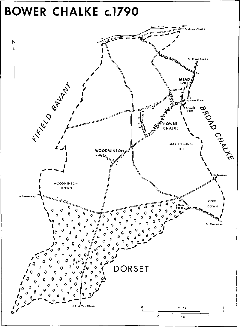
Bower Chalke c. 1790
The lands of Bower Chalke, 15 km. WSW. of Salisbury, (fn. 1) were part of an estate called Chalke, granted to Wilton abbey in the 10th century, and perhaps also of a large parish called Chalke, served from Broad Chalke church in the 11th century. (fn. 2) The name Bower Chalke, apparently given to that part of the Chalke estate where lands were in 'bower hold' tenure, (fn. 3) and the fact that, unlike its neighbours in the Ebble valley, it has land on only one side of the river suggest that Bower Chalke was a late offshoot from Broad Chalke. Bower Chalke had become a separate parish by the early 14th century; a church was built there c. 1300. (fn. 4) In 1885 the southern part of Fifield Bavant, a narrow strip of land running the length of Bower Chalke's western boundary and comprising 283 a., was transferred to Bower Chalke, (fn. 5) increasing its area to 1,319 ha. (3,260 a.). The parish was and is wedge-shaped, broadening from 1.5 km. in the north to 4.5 km. in the south. Its southern boundary, the southern boundary of Wilton abbey's estate and Wiltshire's boundary with Dorset, had possibly been established by the 10th century and was described in the late 11th. (fn. 6) Its northern boundary lies approximately parallel with and 50–100 m. south of the Ebble and so excludes the meadow land beside the river, perhaps because that beside the tributary flowing north from Bower Chalke village was sufficient for the parish or because Fifield Bavant had early established rights over meadows south of the river. The eastern boundary followed the tributary for 500 m., and the western, before 1885, roughly followed a dry valley in the north and ridges in the centre and south. Bower Chalke village and the extremities of it called Mead End, Woodminton, and Misselfore lie within the parish.
The ridge which forms the watershed between the Ebble and other tributaries of the Christchurch Avon extends east and west across the parish. North of the ridge the land, much of it below 137 m., slopes gently to the Ebble and its tributary. Chalk outcrops over most of the parish, but west of the tributary Upper Greensand outcrops. Heights above 200 m. are reached on the ridge, and on Marleycombe Hill the chalk is covered by clay. South of the ridge the land again slopes more gently, to below 122 m. in a gravel-lined valley on the boundary with Dorset. (fn. 7)
Evidence of prehistoric activity has been found in the parish south of the ridge. Groups of barrows stand on Marleycombe Hill and on Woodminton Down, where some 50 burials of the late Bronze Age have been identified. Part of Grim's ditch, which may date from the same period, runs along or parallel with the parish boundary for 1 km. south-west of Cobley Lodge. Other ditches, probably associated with Grim's ditch, run approximately north and south, and another winds for 250 m. across Marleycombe Hill. A field system of 28 ha. is east of the burial sites on Woodminton Down, and one of 53 ha. is on Marleycombe Hill. South-west of Marleycombe Hill there may have been settlement in the Iron Age. (fn. 8)
In historic times most of Bower Chalke's arable lay north of the ridge. There were meadows beside the stream, some of which were converted to watercress beds in the late 19th century and the 20th. The downs in the centre of the parish provided common pasture for sheep. South of the ridge the land was heavily wooded until the 19th century. (fn. 9)
Ox Drove, an ancient ridge way, runs east and west across the parish and is metalled only on Woodminton Down. No major modern route runs through the parish; in the late 18th century and probably earlier the principal road ran south-west from Broad Chalke along the tributary valley, through Bower Chalke village and Woodminton, and across the downs to Sixpenny Handley (Dors.). Another road led north-west and south-east, linking the roads beside the Ebble north of the parish and from Salisbury to Blandford Forum (Dors.). south of it. (fn. 10) Following inclosure in 1792 and in the early 19th century the linking road followed a straight course west of Bower Chalke village. (fn. 11) Earlier and later it ran further east, along Quidham Street. (fn. 12) The western route was a path in the late 20th century. Roads which in the late 18th century ran from the village north to Fifield Bavant and west to Ebbesborne Wake (fn. 13) were unmetalled tracks in 1984. In the late 19th century roads were made parallel with Ox Drove and with the Broad Chalke to Sixpenny Handley road to serve new farmsteads near the parish's southern boundary. South of Marleycombe Hill a road leading south-east from the parish was then diverted westward along the boundary to serve East Chase Farm. (fn. 14)
From the 13th century the lord of Cranborne Chase claimed rights of chase and the right to exercise some forest laws in Bower Chalke, as in other parishes within the chase's outer bounds. The claims were at times resisted. In 1250 the abbess of Wilton, as lord of Chalke manor, alleged that she had been denied the exercise of her rights within her wood called Chettle, in the southern part of Bower Chalke parish. In 1275 it was said that the lord of the chase had then only recently begun to exercise forest law within the wood, and in 1279 it was recommended that the exercise of such law there should cease. (fn. 15) In the 16th century and the early 17th, however, the woodward of Bower Chalke, an officer either of the chase or of Chalke manor, presented inhabitants of Bower Chalke at chase courts for offences which included grazing sheep and pigs in woods subject to chase laws. (fn. 16) Much of the parish apparently lay within that part of the chase called Cobley walk. A lodge for the keeper of the walk lay near the parish's southern boundary until the early 19th century, and was replaced soon afterwards by Cutler's Cottages. (fn. 17) The parish's south-eastern corner was in Vernditch walk, which was sold in 1620 by the lord of the chase, William Cecil, earl of Salisbury, to William Herbert, earl of Pembroke, the owner of the land. In the late 18th century George Pitt, Lord Rivers, lord of the chase, claimed rights of chase on Cow down, in the south-eastern corner; his claims were resisted, apparently successfully, by Henry, earl of Pembroke and Montgomery. (fn. 18) On the disfranchisement of the chase in 1829, its lord received compensation for rights over only 147 a. in Bower Chalke. (fn. 19)
Bower Chalke was assessed for taxation at 90s. in 1334, the highest figure for a single tithing in the hundred, (fn. 20) and in 1377 there were 153 poll-tax payers. (fn. 21) It was again assessed for taxation at a figure above the average for the hundred in the late 16th century. (fn. 22) The population increased steadily from 320 in 1801 to 509 in 1851. Numbers fell thereafter, with some fluctuations. In 1951 the population was 379. (fn. 23) It had risen to 392 by 1971, (fn. 24) but in 1981 was 322. (fn. 25)
Bower Chalke village is on the Upper Greensand in a valley which runs into that of the boundary stream. The main street, called Church Street, is part of the road from Broad Chalke to Sixpenny Handley. In the late 18th century, as in the 20th, there were also houses and farmsteads along Back Lane, part of the Ebbesborne Wake road, and along Quidham Street and Coster's Lane which linked Back Lane and Church Street near the south-west and north-east ends of the village respectively. (fn. 26) The village had presumably grown up along Church Street before the church was built at what in the early 14th century may have been the settlement's south-west end. In the street several substantial stone farmhouses of 17th- or 18th-century origin survive. Two stand at the north-eastern end. Buddens, west of the street, is a 17th-century house of two storeys: its lower brick extension may have been a separate building before it was linked with the house in the 19th century. Bingham's Farm, east of the street, is also of 17th-century origin. (fn. 27) Another stone house, of slightly earlier date and of formal design, was perhaps used as a beerhouse from 1855, (fn. 28) was known in 1886 and 1900 as Grove Cottage, (fn. 29) but from c. 1918 was called the Bell inn. (fn. 30) Laws Farm, an ashlar and rubble house south-west of Buddens, and a large house west of the junction of Church Street and Coster's Lane, were probably built in the 18th century. Smaller houses and cottages of the 17th and 18th centuries also survive; many are thatched. The first settlement in Quidham Street may have been in the 17th century: several singlestoreyed stone and thatch cottages, extended mainly in brick, survive from then. Houses were built between the church and the junction of Church Street and Quidham Street c. 1810, (fn. 31) but most 19th-century building was infilling or replacement in older parts of the village. A farmstead south of Back Lane was replaced by Rookhaye Farm; the brick house was built c. 1830, and it was extended and brick and flint farm buildings were erected shortly afterwards. New building in Church Street in the mid and late 19th century included nonconformist chapels, at the junction with Quidham Street and north of the church, and a vicarage house and a school, respectively south and north-west of the church. At about the same time farmsteads in the street were replaced by new buildings outside the village. (fn. 32) Further infilling took place in the 20th century. At the southwest end of the village private houses were built north-west of Church Street in the 1920s and 1930s, and council houses south-east of it in the 1950s. Private houses and private and council bungalows were built further north and beside Coster's Lane in the later 20th century. Knowle Farm, a late 19th century house with extensive farm buildings south of Bingham's Farm, is part of the village but in Broad Chalke parish.
Mead End, on the chalk north of Bower Chalke village, comprised two or three houses west of the Broad Chalke to Sixpenny Handley road in the late 18th century and the early 19th. (fn. 33) Houses had been built east of the road by 1842, (fn. 34) and bungalows were added east and west of it in the 20th century.
Woodminton, south-west of the village beside a lane leading north-west from the Sixpenny Handley road, was a group of five or more houses or cottages in the mid 16th century. (fn. 35) In the late 18th century both the lane and the settlement were called Woodminton. (fn. 36) Thatched cottages, then standing, survive at the junction of the road and the lane. Other buildings were replaced by houses of the 19th and 20th centuries, scattered along the road and the lane. A farmstead, of brick and flint, was built at the northwest end of the lane in the mid 19th century.
The stone and thatch cottage at the road junction 600 m. south-west of the church was standing in 1773. (fn. 37) By 1842 several more cottages had been built south of it, (fn. 38) one bearing the date 1840. The settlement has been called Misselfore since the early 19th century. (fn. 39) In the late 19th century and the early 20th houses west of the junction on the south side of the Sixpenny Handley road were called Castle. (fn. 40)
Apart from Cobley Lodge and its successors there was no house in the southern part of the parish until the mid 19th century when three farmsteads, Middle Chase, Middle Chase Buildings, and East Chase, were built near the southern boundary. (fn. 41) The farmsteads incorporated, like Rookhaye Farm and Woodminton Farm built about the same time, extensive farm buildings with much flint and red-brick walling. Middle Chase Farm is approached from the north on the road to Sixpenny Handley through an avenue, 500 m. long, of beeches contemporary with the farmstead. A new house and bungalow were built near the farmstead in the 20th century.
Manors and other Estates.
Bower Chalke lay within the estate of 100 mansiunculae (small dwellings) called Chalke granted by King Edwy to the nuns of Wilton in 955. (fn. 42) In the early 13th century CHALKE manor apparently included nearly all the land there and much of Broad Chalke parish. (fn. 43) It passed from Wilton abbey to the Crown at the Dissolution, and in 1542 was granted by the name of Chalke and Broad Chalke manors to Sir William Herbert and his wife Anne for their lives. (fn. 44) In 1544 the estate was granted in tail male to Herbert (fn. 45) (cr. earl of Pembroke in 1551, d. 1570). The manor's lands in Bower Chalke passed with the Pembroke title to Reginald, earl of Pembroke and Montgomery, (fn. 46) who sold them in 1919. Manor farm, 525 a., was then sold to C. J. S. Harding and by him to John Beckley (d. 1966), who was succeeded by his son Mr. J. H. Beckley, the owner in 1984. (fn. 47) Rookhaye farm, 520 a., and East Chase farm, 330 a., were bought in 1919 by J. H. Butler, and in 1936 were conveyed to A. H. Rawle. In 1961 the farms passed to Rawle's son Mr. J. W. E. Rawle, who owned them in 1984. (fn. 48) Middle Chase farm, c. 450 a., and Stonedown Wood, including 244 a. in Bower Chalke, were sold together in 1919 to a Mr. Ingle, (fn. 49) and were bought in 1920 by Marsh Bros. In 1937 the farm was sold to Thomas Brodie (d. 1983), whose son Mr. M. Brodie owned it in 1984, (fn. 50) and the wood to the Forestry Commission, the owner in 1984. (fn. 51) Woodminton farm, c. 500 a., was bought in or after 1919 by a Mr. Bailey, (fn. 52) who sold it soon afterwards to H. J. Barter and Philip Thome. Barter bought Thome's interest in the farm in the 1920s. He was succeeded after 1939 by his son Frank, on whose death in 1976 the farm was divided; c. 300 a. were sold to Mr. David Coward and added to West Chase farm in Ebbesborne Wake, (fn. 53) and the remainder, c. 220 a. still known as Woodminton farm, was bought in 1978 by Mr. R. B. Kennard, the owner in 1984. (fn. 54) Middle Chase Buildings farm, 120 a., was sold in 1919 to W. P. Golden. (fn. 55) It passed in turn to his sons W. J. and H. J. Golden, who held the farm jointly, and to his grandson Mr. W. J. Golden, who owned it in 1984. (fn. 56)
Rectorial tithes and land in Bower Chalke, probably held by Wilton abbey in the mid 13th century, (fn. 57) were apparently part of the endowment of Chalke prebend in the conventual church in 1298. (fn. 58) The abbey in 1448 conveyed to Henry VI the presentation to the prebend, and the king used it to endow King's College, Cambridge, which in the same year was licensed to appropriate Bower Chalke church with the rectorial tithes and glebe there. (fn. 59) The appropriation took place in 1449. (fn. 60) The college held c. 30 a. in Bower Chalke in 1575, (fn. 61) and c. 20 a. in 1792 (fn. 62) and 1842. (fn. 63) The lands were sold in 1921. (fn. 64) The tithes were valued at £352 and commuted in 1842. (fn. 65)
Lands in Bower Chalke were settled in 1199–1200 on Richard of Calstone (fn. 66) (d. in or before 1237). (fn. 67) Walter of Calstone's heirs held the estate of Wilton abbey in 1242–3, (fn. 68) and by 1273 it had passed to Roger of.Calstone who then granted it to John Everard. (fn. 69) John Cole granted it to Roger Pychard and his wife Margery for their lives in 1378. (fn. 70) The estate may have been the later BINGHAM'S farm, which passed from Robert Bingham (d. 1431) (fn. 71) to his son Richard (d. 1482). (fn. 72) Richard was succeeded in turn by his son Robert (d. 1524) and by Robert's son Robert (d. 1561), (fn. 73) but c. 1553 John Bingham was said to hold the farm. (fn. 74) It passed to Robert, son of Robert (d. 1561), (fn. 75) who conveyed it to his son Thomas in or before 1590. (fn. 76) In 1632 Thomas's nephew Richard Bingham held it. (fn. 77) Richard (d. 1656) was succeeded in turn by his son John (d. 1673) and nephew Richard Bingham (d. 1735). Thereafter the farm passed, from father to son, to Richard Bingham (d. 1755), Richard (d. 1823), and Richard (d. 1829), whose relict Priscilla Bingham held it in 1846. (fn. 78) On her death Bingham's passed to Richard Bingham, her husband's nephew, (fn. 79) and was sold by him or another after 1860. (fn. 80) In 1903 it was sold by the executors of William Taunton, (fn. 81) perhaps to R. W. Williamson who owned the farm, 150 a., in 1910. (fn. 82) Thereafter it passed with Knowle farm in Broad Chalke to Mr. D. Mann. (fn. 83)
Bingham's Farm, built of stone in the 17th century, was altered in the 18th to a symmetrical plan with a central western entrance and gable stacks; an eastern service wing was added later. Beside the house, a barn bears the date 1668.
Lands said to be in Woodminton were held with the office of forester of the abbess of Wilton's wood called Chettle, (fn. 84) perhaps by William Foster c. 1255, and later by his son Henry. (fn. 85) An estate, which included the forester's lands and was later called BURLEY'S, was held freely of Chalke manor by William Burley c. 1553. (fn. 86) William (d. 1593) (fn. 87) devised it to his nieces Mary, wife of Thomas Lane the elder, and Bridget, wife of Thomas Lane the younger, and to Richard and Anne Hinton and Elizabeth W'ells, presumably also his kin. (fn. 88) In 1613 William's devisees or their successors sold the estate to Thomas Clarke, (fn. 89) who in 1628 settled it on his son Thomas (fn. 90) (fl. 1632). (fn. 91) Charles Clarke may have held the estate c. 1756; (fn. 92) Henry Rebbeck held it in 1789. (fn. 93) Rebbeck was succeeded c. 1825 by a Mrs. Powell, and she c. 1828 by Alexander Powell (fn. 94) (fl. 1860). (fn. 95) Powell's holding was probably the farm of c. 150 a. owned in 1910 by John Targett. (fn. 96) In or before 1929 Targett sold c. 100 a. to H. J. Butler; (fn. 97) that land was absorbed by Woodminton farm.
Simon Wyther conveyed lands in Bower Chalke to John le Wafre and his wife Isabel in 1267. (fn. 98) Wyther also granted a messuage and 34 a. there to John de Heydore and his wife Emme; the lands were returned to him in 1295 in exchange for a messuage, 48 a., and 20s. rent also in Bower Chalke. (fn. 99) In 1317, when Emme, probably Heydore's relict, held an estate in Bower Chalke with her husband John Carpenter for life, John de Heydore, possibly her son, granted the reversion to William of Tilshead. (fn. 100) An estate formerly TILSHEAD'S was held c. 1553 by Thomas Gawen (fn. 101) (d. c. 1558). It passed in turn to Thomas's son William (d. 1559) and William's son Thomas, who held it in 1590. (fn. 102) In 1705 it was held by Robert Short. (fn. 103) The estate was perhaps that held in 1780 by John Rebbeck (d. in or before 1820), and in 1831 by another John Rebbeck (fn. 104) (fl. 1860). (fn. 105) The lands, c. 70 a., were owned by H. J. Butler in 1910, (fn. 106) and by 1929 had been dispersed. (fn. 107)
The 1 knight's fee in Chalke held by Robert Maskerel and others in 1242–3 is noticed below. (fn. 108)
Economic History.
Nearly all the land of Bower Chalke was held by customary and free tenants of Chalke manor; no demesne arable or pasture of the manor lay within the parish. In 1225 the land was held by 39 tenants. Between them they held stock including 102 oxen, 63 cows, and 944 sheep. The largest flock was of 81 sheep; four tenants had 50 or more sheep each. (fn. 109) Services owed by customary tenants of the manor with lands in Bower Chalke were recorded in the mid 16th century but had presumably been commuted before then. They included washing and shearing sheep, ploughing, harrowing, providing seed corn and sowing it, and reaping and mowing. Some 10 yardlands were 'bower hold'; in addition to the usual rents and services the tenants paid grain rents and were required on leaving their holdings to provide for their successors grain, straw, and money. The tenant of 2 yardlands so held was, for example, to pay his successor 26s. 6d. The tenant of 2 yardlands of 'wetherboodehold' was to provide hurdles when the demesne flock was washed and sheared. (fn. 110)
In 1567 there were four open fields, named after the points of the compass; North, South, and West fields were each of c. 250 a., East field was c. 180 a. There were 600 a. of common pasture on the downs. The 21 copyholders, including two cottagers, held between them some 44 yardlands, including c. 900 a. of arable with pasture for c. 2,800 sheep; 60 a., in small closes, were probably meadow land. They also held a total of 98 a. of 'bourdland'. The average holding, c. 45 a. of arable with pasture for 130 sheep, was large. Five copyholds, a total of 13¾ yardlands, were based at Woodminton but the tenants apparently worked lands and had pasture rights with those of other tenants in the parish. (fn. 111) The number and size of copyholds had changed little by 1631; only two, of 4¼ yardlands and 3 yardlands, were then based at Woodminton. (fn. 112)
The largest freehold in the parish was what became Bingham's farm, said in 1273 and 1378 to comprise 1 hide. (fn. 113) In 1567 it was of 120 a. with pasture for 200 sheep. (fn. 114) Tilshead's was said to include 2 yardlands in 1317 (fn. 115) and the 16th century. (fn. 116) William Burley's freehold comprised 2½ yardlands in 1567, (fn. 117) and in 1593 that farm included c. 60 a. of arable. (fn. 118)
By the early 18th century some copyholds had been converted to leaseholds. In 1705 three leaseholders held between them c. 150 a. of arable with pasture for 450 sheep; of 11 copyholders who then shared 34½ yardlands, three held 4 or more each. (fn. 119) Of a total of c. 1,600 a. held of the manor in 1789, some 1,350 a. were held by 8 tenants, whether by lease or copy is not known. Approximately half the land was arable, half pasture. One holding, of c. 250 a., included c. 120 a. of several pasture on the downs. (fn. 120)
By an award of 1792, under an Act of 1785, the open fields, east and west of the village, and most of the common pastures, in the centre and south of the parish, were inclosed. Allotments were made of 2,576 a. Henry Herbert, earl of Pembroke and Montgomery, lord of Chalke manor, was allotted 2,200 a., including the largest single allotment, 850 a. of woodland south of Ox Drove, and allotments for his lessees and copyholders, none of which was more than 250 a. Allotments were made of 133 a. for Bingham's, 74 a. for Burley's, and 61 a. for the former Tilshead's. The Cow down, c. 100 a. south of Marleycombe Hill, was not inclosed; it remained open to tenants of the manor in summer, and in winter two thirds were grazed by a tenant of the manor and a third by the occupier of Bingham's farm. (fn. 121)
In 1842 the parish comprised c. 1,000 a. of arable, c. 850 a. each of downland pasture and woodland, and c. 120 a. of meadow. There were seven farms of 100 a. or more, four of between 20 a. and 100 a. The largest, Quidham Street, later Manor, farm, was of 457 a. That farm, Rookhaye farm, 287 a., Bingham's, 145 a., and a farm of 122 a. were worked from farmsteads in the village. The farm formerly William Burley's, 109 a., and others of 257 a. and 246 a. were worked from Woodminton; the same tenant held that of 246 a. and Quidham Street farm. (fn. 122) In 1860, under an Act of 1845, new divisions were made of c. 1,100 a., chiefly in the south part of the parish. The Cow down was then inclosed. (fn. 123) Soon afterwards most woodland, except that in the southwest corner, was cleared and three new farmsteads were built, Middle Chase, 1.5 km. south of Woodminton, and Middle Chase Buildings and East Chase, 500 m. and 1 km. north-east of Middle Chase respectively. (fn. 124)
Rookhaye, Manor, Woodminton, and Middle Chase were farms of 450–550 a. in the early 20th century. East Chase then measured c. 350 a. (fn. 125) and there were two smaller farms, Middle Chase Buildings, 120 a., and Bingham's, c. 150 a. (fn. 126) There were dairies on Rookhaye, Manor, and Middle Chase Buildings farms, and sheep were kept on Rookhaye and Bingham's. Most of the farms, however, were then, as in the late 20th century, chiefly arable. (fn. 127) Dairying ceased on Manor and Middle Chase Buildings farms in the 1960s. Middle Chase Buildings was thereafter an arable farm; on Manor farm some pasture was retained on which cattle were reared for beef. (fn. 128) From 1919 Rookhaye and East Chase farms were worked together. Sheep, pigs, poultry, and dairy cattle were kept and cereals were grown. After 1945 they were mainly arable and dairy farms. In 1984, on the combined farms, cereals were grown on over 400 a., there was a dairy herd of 140 cows, and cattle were also reared for beef. (fn. 129) From the 1920s Woodminton was principally a stock farm on which sheep and cattle were kept and corn was grown. After 1976 some 300 a. were worked with lands in Ebbesborne Wake; (fn. 130) the remainder became a mixed farm of c. 220 a. (fn. 131) Arable on Middle Chase farm was, unusually, converted to pasture in the later 20th century, and in 1984 a flock of 450–500 sheep and a herd of c. 70 cattle for beef were kept. (fn. 132) Between 1919 and 1948 and from 1972 Bingham's was worked with Knowle farm in Broad Chalke. (fn. 133) Watercress beds constructed north of Bingham's Farm in or before 1890 (fn. 134) remained in use until 1972. Thereafter they were converted for trout farming. (fn. 135)
Woodland 3 leagues long and 1 league broad, part of Wilton abbey's Chalke estate in 1086, (fn. 136) probably included that wood in the south part of the parish called Chettle in the 13th century (fn. 137) and the 16th, (fn. 138) later part of Chase Woods. In 1567 Chalke manor included 594 a. of woodland in Bower Chalke; hazel and oak grew there. (fn. 139) In the 18th century and the early 19th Chase Woods, which included c. 850 a. in Bower Chalke, was kept in hand when the rest of Chalke manor was tenanted. (fn. 140) Some coppice wood was cut annually in the mid 18th century; 18 a. of wood in Bower Chalke were cut and sold in 1748–9, 60 a. in 1749–50, and 15 a. in 1775–6. (fn. 141) Some 600 a. of wood were cleared between 1860 and 1886; Stonedown Wood, c. 270 a. in the parish's south-west corner, remained. (fn. 142) In 1938 there were hazel coppices, oak, ash, and birch in the wood. Beech, sycamore, and conifers were introduced by the Forestry Commission after 1939 as part of an experimental planting programme. (fn. 143)
Local Government.
A gallows, erected for Wilton abbey at 'Chutelborghe' in the early 16th century, may have stood east of Cobley Lodge near the southern parish boundary. In 1518, however, it was said to be south of the boundary and within South Damerham manor, which belonged to the abbey of Glastonbury (Som.). (fn. 144)
Courts and views of frankpledge held for Chalke manor were attended by the manor's tenants from Bower Chalke. (fn. 145) Tithingmen for Woodminton and Bower Chalke were elected at views held in the mid 16th century (fn. 146) and for Upper and Lower tithings of Bower Chalke from 1727. (fn. 147) The homage of Bower Chalke presented separately from that of Broad Chalke in 1632 and at later courts. (fn. 148) Tenants from Bower Chalke attended courts for Broad Chalke Rectory manor. (fn. 149)
In the late 18th century the parish was lightly rated in comparison with some in Chalke hundred. Between 1775 and 1813, however, annual expenditure on poor relief rose from £84 to £460, a steeper rise than in neighbouring parishes. The number of adults receiving permanent or occasional relief had, however, fallen from 40 in 1802–3 to 31 by 1814– 15. (fn. 150) Thereafter the pattern of expenditure followed that in other parishes of Chalke hundred. It had fallen to £256 by 1816, rose steeply before 1820, and from 1825 until 1830 was between £150 and £250 a year. (fn. 151) Average annual expenditure was £295 between 1833 and 1835. Bower Chalke became part of Wilton poor-law union in 1836 (fn. 152) and of Salisbury district in 1974. (fn. 153)
Church.
Until c. 1300 Bower Chalke may have been part of a large parish called Chalke, probably served by Broad Chalke church. (fn. 154) A church was built at Bower Chalke c. 1300, (fn. 155) and between 1298 and 1307 a vicarage was ordained. (fn. 156) The church was called a chapel of Broad Chalke in 1312, (fn. 157) and inhabitants of Bower Chalke were buried at Broad Chalke until 1506. Thereafter they had the right of burial at Bower Chalke but mortuary fees were reserved to the vicar of Broad Chalke. (fn. 158) Prebendaries of Chalke presented vicars of Bower Chalke from 1307 until 1440. (fn. 159) The advowson passed with the prebendal estate to King's College, Cambridge, in 1448–9, (fn. 160) and in 1449 the college appropriated Bower Chalke church. (fn. 161) The college was patron at most later vacancies. (fn. 162) With the college's consent the bishop of Salisbury collated to the vicarage the vicar of Broad Chalke, who held it in commendam in 1505–6. (fn. 163) The vicarage was again held with Broad Chalke vicarage from c. 1530 and, in addition, with Alvediston vicarage from 1584 or earlier. From the early 17th century the combined living was described as the vicarage of Broad Chalke with Bower Chalke and Alvediston chapels. (fn. 164) The suggestion made in 1650 that the living be divided (fn. 165) was apparently not implemented. In 1880 a perpetual curacy of Bower Chalke was created as a separate living in the gift of King's College. (fn. 166) Incumbents were usually called vicars. (fn. 167) The living was reunited with Broad Chalke vicarage in 1952, (fn. 168) and the parishes were served by the Chalke Valley group ministry from 1972. (fn. 169) In 1981 the united benefice became part of Chalke Valley West benefice. (fn. 170) King's College was patron of the united benefice from 1952, (fn. 171) and of Chalke Valley West at the first of every three turns from 1981. (fn. 172).
In 1535 the clear annual value of Bower Chalke vicarage was £10, well below the average for a living in Chalke deanery. (fn. 173) In 1720 Edward Colston and King's College each gave £100 to augment the Bower Chalke portion of the combined living, (fn. 174) and by 1728 £200 had been given by Queen Anne's Bounty. (fn. 175) The benefactions may have been used to buy an estate at St. Mary Bourne (Hants), from which the incumbent of the combined benefice received £15 a year in 1782. (fn. 176) No later reference to the estate has been found.
In the 17th century the incumbent of the combined benefice received from Bower Chalke corn and hay tithes from the rectorial glebe and all wool and other small tithes. (fn. 177) In 1842 those tithes were valued at £100 and replaced by a rent charge. (fn. 178) There was a vicarage house but no other vicarial glebe at Bower Chalke in 1671. (fn. 179) The house, in poor repair in 1781, (fn. 180) may have been that described c. 1830 as a cottage and used by the churchwardens for charitable purposes. (fn. 181)
The income of the combined benefice from Bower Chalke was transferred to the perpetual curacy of Bower Chalke in 1880. King's College gave £856 to endow the new living, and the vicar also received £50 yearly from the Ecclesiastical Commissioners. A vicarage house was built south of the church in 1880; (fn. 182) it was sold in 1961. (fn. 183).
From the 1530s Bower Chalke was served by curates; the absence of the incumbent and the resulting inadequate service of the cure caused complaints. (fn. 184) In 1650, however, curates employed by the incumbent John Sloper to serve Bower Chalke and Alvediston chapels were praised for preaching regularly. (fn. 185) Sloper's failure to say divine service twice on Sundays, for which he was presented in 1662, may reflect disapproval of the rites of the Restoration church (fn. 186) or the problems of serving three parishes. In 1783 a curate served all three parishes; one weekly service, on Sunday afternoons, was held at Bower Chalke. Communion was celebrated at four festivals. (fn. 187) In the 19th century a curate usually lived in the parish. (fn. 188) The service held on Census Sunday in 1851 was attended by 240 people, including 75 children. (fn. 189) Rowland Williams, incumbent of the combined benefice from 1858 to 1870, introduced a second Sunday service at Bower Chalke. Daily services were also introduced, without success. (fn. 190) In 1864 the average congregation at Sunday services was 65; additional services at festivals and in Lent were usually attended by 20 people. Communion was celebrated still only four times a year. (fn. 191) Edward Collett, curate of Bower Chalke 1878–80 and vicar 1880–1924, introduced many Anglo-Catholic practices into the parish including, by 1914, daily celebrations of communion. From 1882 until 1922 he also wrote and printed, on a press in the vicarage house, a weekly parish newspaper. (fn. 192)
HOLY TRINITY church, so called in the mid 19th century, (fn. 193) is built of ashlar and has a chancel and a nave with transeptal chapels, south aisle, and north porch surmounted by a tower with a pyramidal roof. Although the font is of the 12th century, the oldest parts of the building are of c. 1300; the transept arches and part of the nave's north wall, including the doorway, survive from a cruciform church, without aisles, of the later date. In the 15th century the porch and tower were added, and in the late 15th century or the early 16th new windows were made in the transepts. The tower was said to need repair in 1662. (fn. 194) In 1820 the upper part of it was rebuilt. (fn. 195) The church, said, with little apparent justification, to be too small for the congregation in 1864, (fn. 196) was restored and enlarged in 1865–6 under the direction of T. H. Wyatt. The south aisle was added, the tower was heightened, and the chancel and part of the nave were rebuilt. A west gallery was removed. (fn. 197)
In 1553 a chalice weighing 15 oz. was left in the parish; 4 oz. of plate were confiscated. The parish had a silver chalice and vessels of pewter c. 1830, a paten, acquired in 1866, and a 19th-century chalice, both silver-plated, in 1891. (fn. 198) The vessels of 1891 had been replaced by 1959 by a new chalice and paten (fn. 199) which, with another chalice and paten which may previously have belonged to Broad Chalke, were held by the parish in 1984. (fn. 200) There were three bells in 1553. A 17th-century bell, recast by John Warner & Sons in 1880, a bell of 1611, by John Wallis, and a third, of 1899, by Roger Lander, hung in the church in 1984. (fn. 201) The registers are complete from 1701. (fn. 202)
Nonconformity.
A house in Bower Chalke was licensed for Presbyterian meetings in 1672. (fn. 203) There was said to be no dissenter in the parish in 1783, (fn. 204) but a house was licensed for meetings of Independents in that year. (fn. 205) The Independent congregation in Bower Chalke was served with others in Broad Chalke and Ebbesborne Wake from 1812 but from 1816 had its own minister. (fn. 206) Meetings may still have been held in 1824 (fn. 207) but probably ceased soon afterwards.
In 1851, on the morning of Census Sunday, 54 people attended a Baptist meeting in Bower Chalke. (fn. 208) A small chapel of red brick was built in 1863–4. (fn. 209) It was converted to a schoolroom and a larger chapel built adjoining it in 1897. (fn. 210) The chapel was open in 1984.
Primitive Methodists held an evening service in a house on Census Sunday in 1851; the claim that it was attended by 96 people (fn. 211) seems exaggerated. By 1859 a building near the meeting house had been converted for use as a chapel. Plans were made to extend the chapel (fn. 212) but in or before 1864 it was closed. (fn. 213) A Wesleyan Methodist chapel, built in 1879, remained in use until c. 1983. (fn. 214)
Education.
In 1833 there were two day schools in Bower Chalke, attended by a total of 16 children. (fn. 215) A National school was built near the church in 1844. (fn. 216) Average attendance was 70 in 1858, (fn. 217) and 50 in 1861. (fn. 218) An additional classroom and a teacher's house were built in 1870. (fn. 219) From 1898 to 1907 average attendance was between 70 and 80. (fn. 220) By 1914 it had fallen to 56, (fn. 221) and by 1936 to 27. (fn. 222) The school was closed in 1976; (fn. 223) thereafter children from Bower Chalke attended Broad Chalke school. (fn. 224) A few children were taught in a cottage on the downs west of Middle Chase Farm between 1869 and 1897. (fn. 225)
Charity for the Poor.
At inclosure in 1792 an allotment was made of 10 a. from which poor parishioners were entitled to take fuel. In the late 19th century the allotment became bare of furze and was exchanged for another 10 a. (fn. 226) The land was sold in 1972, (fn. 227) under a Scheme of 1970, and the proceeds invested. In 1973–4 the income was £344, of which £210 was spent on food and assistance for needy parishioners. (fn. 228)