A History of the County of Wiltshire: Volume 14, Malmesbury Hundred. Originally published by Victoria County History, London, 1991.
This free content was digitised by double rekeying. All rights reserved.
'Parishes: Malmesbury', in A History of the County of Wiltshire: Volume 14, Malmesbury Hundred, (London, 1991) pp. 127-168. British History Online https://www.british-history.ac.uk/vch/wilts/vol14/pp127-168 [accessed 18 April 2024]
In this section
MALMESBURY
The Town of Malmesbury stands on a steep hill almost encircled by the Tetbury and Sherston branches of the Bristol Avon. (fn. 1) The streams, flowing eastwards, come within 200 m. of each other at the town's north-western corner, diverge, and meet at its southern end. (fn. 2) The word Malmesbury was perhaps derived from the name of Mailduib, an Irish monk or hermit who may have settled on or near the town's site in the mid 7th century. Mailduib is said to have gathered around him a school which became the nucleus of the monastery later known as Malmesbury abbey. (fn. 3) A tradition was current in the abbey in the 14th century that Mailduib's settlement lay beneath a fortified place, called either Bladon or by the Saxon name Ingelbourne, which had been constructed by a heathen British king, had once been a thriving town, but was in Mailduib's time little frequented. (fn. 4) Malmesbury's naturally defensible site may have been that of a stronghold in an earlier period, but the tradition cannot be substantiated. Between the 7th century and the 11th the abbey was granted many estates near Malmesbury, including the lands, surrounding the town, which became Malmesbury and Westport parishes. (fn. 5) The two parishes may have been formed early: there was a church at Westport in the late Saxon period and the site of St. Paul's, the medieval parish church of Malmesbury, in or adjacent to the abbey precinct perhaps indicates a similarly early origin. The parishes were closely associated: the settlement called Westport formed a suburb of the town, and what became Malmesbury borough included part of that settlement and had most of its common land in Westport parish. (fn. 6)
Malmesbury parish comprised most of the town, but not the abbey precinct and the part in Westport parish, and lands north, east, and south of it. Within the parish were the villages or hamlets of Milbourne, Whitchurch, and Blick's Hill to the east, Burton Hill immediately south of the town, and Corston and Rodbourne further south. A settlement called Filands, north of the town, lay mainly in Westport parish. (fn. 7) The name of another, Walcot, in either Westport or Malmesbury parish may indicate an early settlement site or proximity to the town walls; the only references to it are from the late 13th century. (fn. 8) From the 14th century or earlier there was a chapel, dependent on St. Paul's church, at Corston and another at Rodbourne. (fn. 9) Each chapelry was a tithing: although neither relieved its own poor, both Corston and Rodbourne were thus separate from Malmesbury in some ecclesiastical and administrative matters. The main part of the following article deals with all Malmesbury parish except Corston and Rodbourne, with the abbey precinct which was apparently considered extraparochial until the 18th century when it relieved its own poor, (fn. 10) and with the history of the town including some aspects of that part of it which lay in Westport parish. Corston and Rodbourne are dealt with in separate accounts at the end of the article.
Malmesbury parish, including the abbey precinct, Corston, and Rodbourne, measured 10 km. from north to south and at its widest, south of the town, 5 km. from east to west. It narrowed where crossed by the two branches of the Avon, and 360 a. to the north were attached to the rest of the parish by a neck of land north-east of the town. Further north again c. 20 a. in two parcels were detached, one surrounded by lands of Brokenborough parish and one between Brokenborough and Charlton; north of Milbourne village were c. 10 a., parcels of Westport and Charlton parishes, enclosed by Malmesbury lands. (fn. 11) The boundary of the 360 a. with Charlton was marked by a stream, but the boundaries with Brokenborough and Westport were irregular: that irregularity, and the existence of islands of other parishes in Malmesbury and of Malmesbury in other parishes, may be the result of inclosure and allotment of land shared by several parishes, of basing parish boundaries on the ownership of land with which tithes were merged after the Reformation, or of both. Further south the parish's eastern boundary was marked by the Avon, its tributary Woodbridge brook, and another tributary, while a tributary of the Sherston Avon marked part of the western boundary. Elsewhere the parish boundary was marked by few natural features, but on the western side of the town it may have followed part of the town wall and in other places was marked by roads. The boundaries of Rodbourne and Corston were surveyed in the late 11th century or early 12th when the road dividing Corston and Hullavington was mentioned and the Avon was Rodbourne's boundary with Little Somerford. (fn. 12) That last boundary was diverted west from the Avon, its natural line, at an agreed inclosure in 1281. (fn. 13) In the early 1630s, after the disafforestation of Braydon forest in 1630 and disputes with other landowners, the lord of Whitchurch and Milbourne manor was allotted 104 a. of the purlieus c. 6 km. east of the parish: (fn. 14) that allotment, Milbourne common, was part of Malmesbury parish in 1839. (fn. 15)
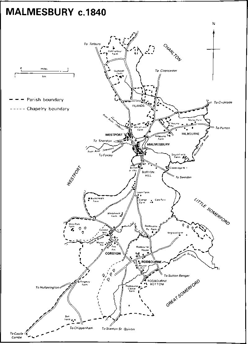
Malmesbury c. 1840
In the period 1882–4 the detached parts of Malmesbury parish to the north were transferred to Brokenborough, Milbourne common was transferred to Brinkworth, and the detached parts of Westport and Charlton embraced by Malmesbury parish were transferred to Malmesbury; north of the town there were also small changes to the boundaries with Westport and Charlton. (fn. 16) In 1885, after losing c. 100 a. in the changes of 1882–4, Malmesbury parish measured 5,333 a. (2,160 ha.), of which Corston and Rodbourne were a total of c. 2,500 a. (fn. 17) In 1886 Malmesbury municipal borough was created; it contained 178 a. formerly part of Malmesbury, Westport, and Brokenborough parishes. (fn. 18) In 1894 the reduced Malmesbury parish was renamed St. Paul Malmesbury Without parish; to it was added in 1896 all Westport parish outside the borough. (fn. 19) In 1981 it measured 2,903 ha. (7,173 a.). (fn. 20) In 1984 small areas were exchanged between that parish and Brokenborough, and some land was transferred from it to Malmesbury parish. (fn. 21) Thereafter St. Paul Malmesbury Without measured 2,699 ha. (6,669 a.). (fn. 22)
From the confluence of its Sherston and Tetbury branches the Avon flows south-east across the old Malmesbury parish, turning south near the eastern boundary. The name Ingelbourne was applied to the Tetbury branch in the 11th or 12th century and in the later 15th, and to the Sherston branch in the later 13th; it may also have been used for a stream rising south-west of the town. (fn. 23) Most of the tributary streams cross the parish from west to east. Gauze brook flows north-east across the southern half of the parish to join the Avon on the eastern boundary, and further south is a parallel stream, formerly called the Rodbourne; the names were in use c. 1100, when both streams were boundaries of Rodbourne, and perhaps much earlier. (fn. 24) The town stands on a steep sided outcrop of Cornbrash, above 76 m. Elsewhere the steepest slopes in the parish are around Rodbourne village. Nowhere does the land rise much above 90 m. and in the north and south-west it flattens out at that height. Kellaways Clay outcrops over most of the parish and there are small areas of Oxford Clay. Kellaways Sand outcrops near Rodbourne, and there are outcrops of clay of the Forest Marble beside the Avon and in the extreme north. In the lower parts of the parish, especially between the town and Corston village, Cornbrash outcrops. Alluvium has been deposited by the Avon and its main tributaries, and deposits of sand and gravel are in several places north of the town. (fn. 25)
Although the well watered clay soils favour pasture rather than tillage, open fields on the clay lay south of Milbourne village and in the north. The Cornbrash favours arable and the open fields near Corston village were on both the Cornbrash and clay. Most of the land between Gauze brook and the town was pasture and parkland from an early date. What became Cole park, beside the Avon south of the town, was wooded in the Middle Ages, but later there was little woodland in the parish. In the 19th century and the 20th there were quarries near Corston village and on the outskirts of the town, and the clay in the southern part of the parish was used for making bricks. (fn. 26) From 1935 the plateau in the south-western corner has been part of R.A.F. Hullavington. (fn. 27)
Malmesbury and Westport c. 1845
In the later 17th century the Oxford—Bristol road ran east and west through Milbourne village, Malmesbury, and Foxley crossing the Tetbury Avon by a stone bridge at the town's north-east corner. (fn. 28) The main road south from the town has always been that through Corston to Chippenham, called Kingway c. 1100 when it may have been on roughly its present course. (fn. 29) To the north the Tetbury (Glos.) road also served until 1778 as a link from Cirencester (Glos.) to Malmesbury and Chippenham, before 1743 via the Foss Way, thereafter alternatively on a turnpike road to Tetbury. (fn. 30) In 1756 the Tetbury—Malmesbury and Malmesbury—Chippenham roads were turnpiked to complete a Chippenham—Cirencester turnpike road via Tetbury. By then the Oxford—Bristol road may already have declined in importance and, east of the town, the more northerly Cricklade—Malmesbury road and, west of the town, the more northerly Malmesbury—Sherston road were turnpiked. (fn. 31) The road through Milbourne remained in use as a minor road. A more direct Cirencester— Malmesbury road was completed across Hankerton parish and turnpiked in 1778. (fn. 32) Another road, which left the Chippenham road south-east of the town, crossed the Avon by Cow bridge, and led to Wootton Bassett and Swindon, was in use in 1773 and turnpiked in 1809. (fn. 33) The Chippenham, Cirencester, and Tetbury roads were disturnpiked in 1874, the Cricklade, Swindon, and Sherston roads in 1876. (fn. 34) In 1973 the Cirencester—Chippenham road was diverted to bypass the town to the east. (fn. 35) There were few minor roads in the north part of the parish in the late 18th century. One, linking the Tetbury and Cirencester roads, was still in use in the late 20th century; since 1973 it has assumed greater importance by taking Chippenham—Tetbury traffic away from the town. Another, running north-west from the linking road east of and parallel with the Tetbury road, (fn. 36) was in use in 1842 but not in 1885. (fn. 37) South of the town in the late 18th century lanes led east and south-east from the Chippenham road to Sutton Benger, to Rodbourne village, and to a road between Rodbourne and Stanton St. Quintin; they were crossed by others running north-east and south-west. Lanes led south-west from the Chippenham road 1 km. south of the town and west from it at the north end of Corston village to Malmesbury common in Westport parish, and further south one led west to Hullavington and another south-west along the parish boundary towards Castle Combe. (fn. 38) The road towards Castle Combe went out of use in the 19th century after a road through Hullavington village was turnpiked, but the road to Hullavington, part of that turnpike road, remains in use. (fn. 39) In the late 20th century the Sutton Benger road and that leading to it from Corston village were the only public metalled roads east of the Chippenham road, and Common Road, leading west from the north end of Corston village, was the principal route to Malmesbury common.
A canal between Bristol and Cricklade passing south-east of the town was planned in the late 18th century but not built. (fn. 40) A railway line through Malmesbury was proposed in 1864 but there was no service to the town until 1877 when a branch from the G.W.R. line at Dauntsey was opened. The new line skirted the town to the north-east, a tunnel was made under Holloway, and a small station was built east of the Tetbury Avon north of the abbey church. Part of the Bristol & South Wales railway was built across the south part of the parish in 1903, and in 1933 a spur was built to connect the Malmesbury branch to that line at Little Somerford; the southern half of the branch was then closed. Passenger services to Malmesbury ceased in 1951, (fn. 41) and goods services in 1963 when the station was closed. (fn. 42)
Despite the literary tradition of early settlement within the parish, little archaeological evidence of human activity in prehistoric times has been found. Some artifacts of the Iron Age and later have been found in the town and in the south part of the parish. On Cam's Hill south-east of the town are rectangular and circular prehistoric enclosures measuring 0.5 ha. and 0.25 ha. respectively. (fn. 43)
In 1377 a total of 556 poll-tax payers lived in Malmesbury, in other villages in the parish, and, probably, in the suburb of Westport. (fn. 44) The population of the parish was 1,571 in 1801. Between then and 1851 it increased steadily to reach a peak of 2,581, and between 1851 and 1891 it declined. The sharpest fall, from 2,543 in 1861 to 2,306 in 1871, was ascribed to the emigration of labourers to work in the oilfields of Ohio (U.S.A.). In 1891, the last date for which figures are available, 2,263 people lived in what had been Malmesbury parish. (fn. 45) In 1981 the population of Malmesbury St. Paul Without parish was 1,993. (fn. 46) In 1773 and 1842, as presumably earlier, settlement was concentrated in the town and in Milbourne, Corston, and Rodbourne villages. There was a group of buildings at Burton Hill and scattered farmsteads in most parts of the parish. (fn. 47) The histories of the villages, hamlets, and farmsteads in the parish, apart from those of Corston and Rodbourne, which are dealt with separately, are described below after the account of the town.
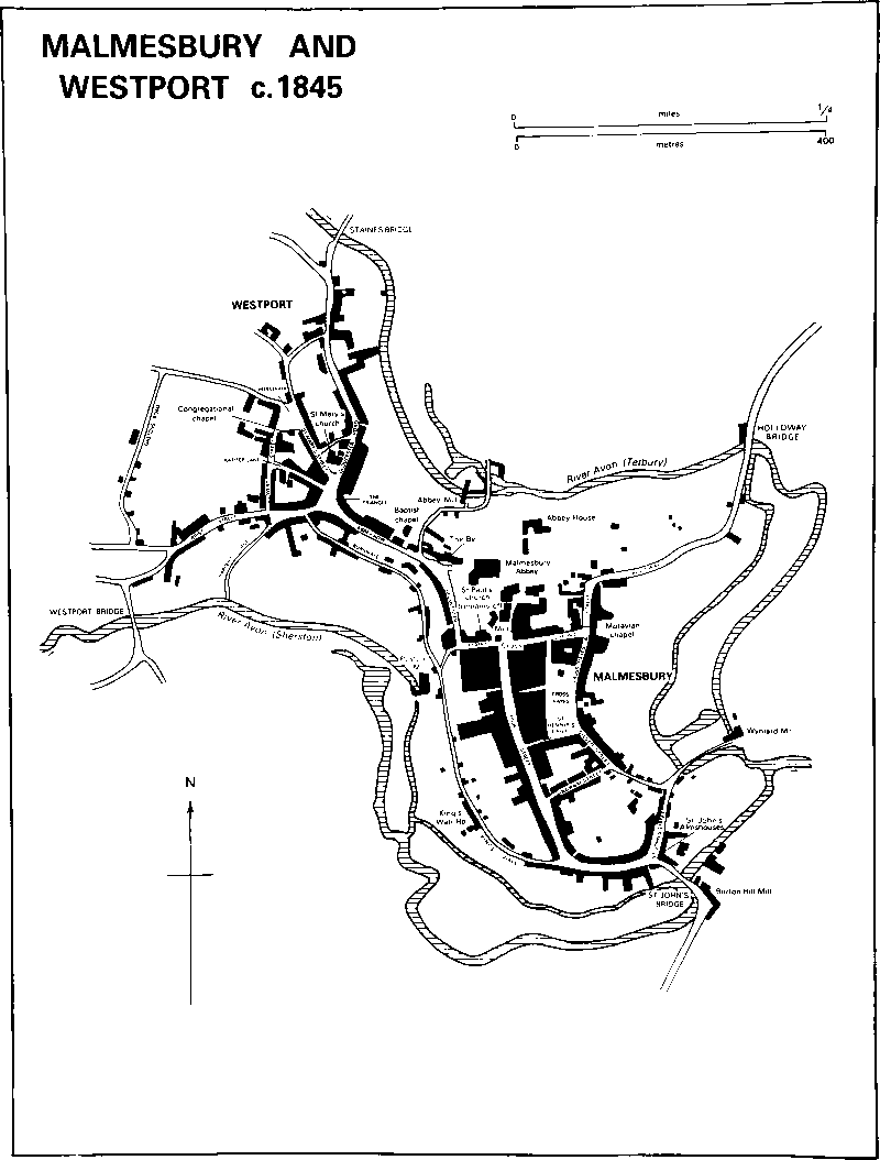
Town history. The town which grew up around Malmesbury abbey had probably become a local trading centre by the late 9th century. At about that time it was included with three other places in Wiltshire in the list of fortified centres known as the Burghal Hidage: 1,200 hides were assigned to defend the fort which may therefore have had 1,650 yd. of wall. Moneyers worked at Malmesbury from the mid 10th century and coin evidence suggests that the town was one of the most important in the county in the early 11th. Its eminence was confirmed by Domesday Book, in which it was referred to as a borough, placed at the head of the entry for Wiltshire, and described in more detail than any other borough in the county, although it was not necessarily the largest or most prosperous. Within the borough in 1086 the king had 26 masurae hospitate, possibly houses let at rent, and 25 masurae exempt from geld, perhaps occupied by the king's servants; each masura may have consisted of more than one house. A further 22¾ masurae were held by other lords; in addition 8 or 11 burgesses of Malmesbury and 5½ houses in the borough were mentioned elsewhere in the survey as appurtenant to rural estates. Thus, although smaller than many others, the borough may have had in it 100 or more households. The mint in Malmesbury was the only one of perhaps five in Wiltshire to be mentioned in Domesday Book. (fn. 48) Between the nth and the 16th centuries Malmesbury's importance in the county declined, although it was still highly assessed for tax in 1334 and was apparently populous in 1377. (fn. 49) In the later Middle Ages it was notable chiefly for its abbey and for its cloth industry, which was to remain a source of its prosperity until the mid 18th century. From the 18th century it was principally a local centre for commerce, manufacture, and administration. (fn. 50)
Before the Conquest Malmesbury was required to give to the king 20s. for his fleet when he went on an expedition by sea or a man for each five of its hides, probably three men, when he went on an expedition by land. Such a requirement suggests that Malmesbury was already a privileged borough. (fn. 51) A guild merchant had rights and lands and presumably played some part in the town's government in the 13th century. The burgesses' privileges, including exemption from certain dues, and lands, later called King's Heath or Malmesbury common, were confirmed in 1381 when the burgesses made the implausible claim that they had been granted by King Athelstan. The governing body was known from the 16th century or earlier as the alderman and burgesses. (fn. 52) In the 16th century the borough presumably included all the land within the town walls, except that within the abbey precinct, and an area in Westport beyond the walls. The extension of the borough boundary across the neck of land linking Malmesbury and Westport may have been to bring within the borough the markets and settlements which had grown up outside the confined area of the town; a Thursday market granted in 1252 was for Westport, and both the Triangle and Horsefair in Westport, within the borough boundary, may have been the sites of markets or fairs. (fn. 53) In the late 13th century the walled part of the town within Malmesbury parish was called Bynport to distinguish it from Westport: the name was still in use in the 16th century. (fn. 54) The alderman and burgesses may have exercised rights over the abbey site from the Dissolution, but the precinct was not formally included in the borough until 1685. (fn. 55) The earliest map showing the borough boundary is of 1831. The east, south, and south-west boundaries were the two branches of the Avon, and the north was a ditch then called Warditch. The north-western, between the Tetbury road and the Sherston Avon and taking in part of Westport, was in places marked by streets but followed an indirect line and for much of its distance no prominent feature. Approximately a third of the borough lay in Westport parish. (fn. 56)
In 1831 it was proposed to extend the borough boundary where each of four main roads entered the town. There is no evidence that extensions were made, but the urban sanitary district formed in 1872 took in an area greater than the 1831 borough, and its boundaries were those of the municipal borough created in 1886. (fn. 57) In 1894 the municipal borough was divided into the civil parishes of the Abbey, Malmesbury St. Paul Within, Westport St. Mary Within, and Brokenborough Within. The Abbey and Malmesbury St. Paul Within included the parts of the town formerly in Malmesbury parish. The other two were those parts of Westport and Brokenborough parishes brought into the urban sanitary district in 1872: they were merged as Westport St. Mary Within in 1897. (fn. 58) In 1934 a further 25 a. of Brokenborough parish on the west side of the town were added to the borough. The three civil parishes within the borough were then merged as a new Malmesbury parish, (fn. 59) to which was added in 1956 part of a built up area in Brokenborough and St. Paul Malmesbury Without. (fn. 60) In 1974 Malmesbury lost its borough status, (fn. 61) and in 1984 Malmesbury parish was extended west, north, and east, bringing more housing within it and increasing its area from 93 ha. (230 a.) to 283 ha. (699 a.). (fn. 62)
In 1547 the adult population of the town of Malmesbury, presumably including its suburbs, was estimated at 860, the third largest total for a town in Wiltshire. (fn. 63) In 1801 the population of the town, apparently defined as the borough, was 1,107. It rose steadily to 1,624 in 1861, and in 1891 the municipal borough had 2,964 inhabitants, of whom 1,348 lived in that part of it which had been in the old Malmesbury parish. Numbers fell until 1931, when the borough had 2,334 inhabitants. The population of the enlarged borough was 2,510 in 1951; (fn. 64) in 1971, after further enlargement, it was no more than 2,610 and in 1981 Malmesbury parish had a population of 2,591. (fn. 65)
The chief buildings of the town stood in Malmesbury parish on the peninsula formed by the two branches of the Avon. At the northern end, on the highest ground, was the abbey. In the 1130s, when he held Malmesbury abbey and a lease of the borough from the Crown, Roger, bishop of Salisbury, built at Malmesbury a castle which reportedly encroached on a graveyard within a stone's throw of the abbey church. (fn. 66) Its site was probably west of the church, either that occupied in the late 20th century by the eastern range of the Old Bell hotel, formerly called Castle House, (fn. 67) or further west, beyond the lane which bounded the hotel. Another suggested site, east of the abbey church and encroaching on the monks' graveyard, (fn. 68) offered little command of the western approach to the town where the natural barriers were weakest. In 1215 the Crown granted the keeping of the castle to Malmesbury abbey, which in 1216 was licensed to demolish it and build on its site. (fn. 69) A document, apparently compiled by the abbey in the later 13th century, lists obligations to repair 26 sections of the town's wall, presumably its whole length. Those required to repair the wall, including the abbey itself in eight sections, were apparently the owners of the plots in the borough adjoining the respective sections. The correlation between the owners and the holders of the masurae listed in Domesday Book has given rise to the suggestion that the walls and the obligation existed in 1086, but it has been more plausibly suggested that although the wall was referred to in the document as the king's wall the obligations were imposed or defined only after the abbey acquired the castle. The stone wall may therefore also have been built by Roger in the 1130s. (fn. 70) Roughly parallel with the rivers, it may have followed the lines of earlier defences, possibly those of the later 9th century. The wall was still standing in the earlier 16th century but was then said to be very feeble. (fn. 71) It probably suffered further damage during the Civil War (fn. 72) and by c. 1800 had largely disappeared. (fn. 73) The eastern and south-eastern line of the wall was marked in the later 20th century by the boundaries of the plots behind Cross Hayes Lane, Silver Street, and Ingram Street, and the western by paths parallel with and above the lanes called Burnivale and King's Wall. To the north the wall may survive as the garden wall of the Old Bell; east of the Old Bell the town wall was the outer wall of the abbey buildings which extended to the edge of the steep slope above the river. In the late 13th century there were at least four gates; the east gate was across the Oxford road, there called Holloway; Wyniard gate was a little gate at the south end of what became Silver Street; the south gate was at the southern end of High Street; and the postern late 18th century. (fn. 74) In the late 20th century one jamb of the east gate survived in Holloway, and the rounded plan of the house at the junction of King's Wall and High Street may have reflected that of the west side of the south gate.

Malmesbury Boundaries 1931–1984
The plan of the town within the walls had largely been established by the late 13th century and had changed little by the late 20th. The extent of the abbey precinct was marked by the southward diversion of the old Oxford—Bristol road around three sides of a rectangle, near the south-western gate was at the junction of King's Wall and Burnivale. A fifth, west, gate was mentioned in the earlier 13th century and may be identified with the bar in Westport recorded later in the century. It was presumably across what became Abbey Row, at or near the castle site, and foundations opposite nos. 31 and 33 Abbey Row have been identified as those of the gate. The gates were all ruinous in the early 16th century. The east gate and the postern gate were not, however, removed until the corner of which stood St. Paul's church. The precinct may have been extended south to those boundaries either in the 12th century, when the abbey church was rebuilt, or by William of Colerne, abbot from 1260, in whose time the abbey buildings were much enlarged. (fn. 75) Apart from the abbey church and the undercroft of Abbey House, the most substantial monastic building surviving in the late 20th century was the central east-west range of the Old Bell hotel. The range, of two storeys each divided into two rooms by a central chimney stack, was probably built in the 13th century to incorporate the abbot's lodging. The names of streets in the town are recorded in a rental of the late 13th century or the early 14th. High Street, called magna strata, presumably then as later formed the town's spine, running south from the abbey to the confluence of the two branches of the Avon; East Street was probably a parallel street following the line of the later Cross Hayes Lane and Silver Street. The streets were joined by lanes running east and west; Philip's Lane may have been the eastern part of the Oxford—Bristol road which skirted the abbey precinct, known from the 17th century as Oxford Street, and Griffin's Lane further south apparently became St. Dennis's Lane. The name of Ingram's Lane survives as Ingram Street. A market place adjacent to High Street may have been that within the abbey precinct, opposite the north end of High Street, where an octagonal vaulted market cross was built in the 15th century, or Cross Hayes which was mentioned in the rental and was presumably then as later an open space. King's Wall lay along the outside of the west part of the wall; further north a chapel, which became known as the Hermitage and was demolished in the early 19th century, stood in Westport parish between the lane later called Burnivale and the town wall. In the late 13th century the name Burnivale was apparently used for all or some of that part of the town which lay within Westport parish. At the southern end of the town Nethewall was the area between the wall and the lower parts of High Street and Silver Street, (fn. 76) below which Mill or St. John's bridge carried the Chippenham road across the river. St. John's hospital (fn. 77) had been built there by the 13th century; a blocked doorway of c. 1200 and other medieval stonework were incorporated into the south-west front when the hospital was rebuilt as almshouses probably in the 17th century. (fn. 78) Other buildings of medieval origin which survived in the late 20th century stood on or near the boundary of the abbey precinct. A building which became the Green Dragon inn, north-west of the market cross, incorporated a stairway perhaps of the 14th century; near the south-eastern corner of the precinct Tower House, which was extended in the 17th century and later, incorporated a later medieval roof with arch-braced collars; no. 8 Gloucester Street, formerly the White Lion inn, had a courtyard plan and may be of 16th-century origin. Mills were built beside the rivers on the outskirts of the town; in the later Middle Ages they occupied sites north of the abbey, below the postern gate, and beside Mill bridge and Wyniard, later Goose, bridge. In the late 13th century or the early 14th the Tetbury Avon was crossed by the Oxford—Bristol road over St. Leonard's, later Holloway, bridge and by the Tetbury road over Theyn, later Staines, bridge. (fn. 79)
The abbey church survived the Dissolution and replaced the ruined St. Paul's as the parish church of Malmesbury. (fn. 80) Other monastic buildings were used as workshops in the 1540s, (fn. 81) but most were probably demolished in the mid or late 16th century. In 1561 buildings in the borough were said to be in great decay; (fn. 82) the description presumably refers to the former abbey. A proposal by William Stumpe, the purchaser of the abbey site, to build a row or rows of weavers' houses north-east of the abbey church (fn. 83) apparently came to nothing. In the later 16th century, however, Stumpe's son Sir James built Abbey House there. (fn. 84) The house has a half H plan with two storeys and gabled attics: its central, northern, range is over a 13th-century undercroft, and it has short wings to the south. The undercroft, the vaulted roof of which was demolished, was partly filled to form a basement. There was a hall on the ground floor of the central range, in the east wing were parlours, and in the west wing kitchens and service rooms. A turret, housing a newel stair, was built in the angle between the hall and the east wing, and the main south front had a low porch bearing the arms of Stumpe and his wife Isabel Baynton. (fn. 85) There was probably a walled forecourt south of the house, and a re-used 12th-century arch, which survived in the late 20th century, was incorporated in the south part of the wall in line with the porch. In the early 19th century a low wing extended eastwards from the house and a long two-storeyed range ran south from the west wing; both were probably of 17th-century origin. (fn. 86) The western extension was demolished, probably in the early 20th century when the eastern extension was replaced by a two-storeyed wing with attics similar in style to the original building. In 1636 there were c. 60 houses within the former precinct and most of the inhabitants were poor. (fn. 87)
Abbey House is the only large house to have survived from the late 16th century or the early 17th. No. 9 Oxford Street is a gabled house of stone with a late 16th-century roof and is said to have been used as a guildhall. (fn. 88) Partly timberframed buildings with jettied first floors survive at nos. 6 and 10 Gloucester Street, no. 9 High Street, and in the gabled southern wing of the King's Arms in High Street. No. 6 Oxford Street, sometimes called Manor House, has an elaborate early 17th-century staircase rising through three storeys. Houses in Abbey Row were said to have been destroyed in the Civil War, perhaps during Sir William Waller's capture of the town in 1643, and there may have been other destruction arising from the military occupation of Malmesbury, (fn. 89) but it is not possible to identify areas of post-war reconstruction. The main range of the King's Arms is probably late 17th-century, as is the substantial building later subdivided into nos. 5 and 7 High Street. The Old Brewery, north-east of the market cross, bears the date 1672 on a gable, and the much restored frontage of no. 46 High Street has a date stone for 1671. Stone was the normal building material by that time, but the chimneys of nos. 5 and 7 High Street are of red brick and have diagonally set shafts. Away from the centre of the town a number of smaller houses are of one storey and attics with large gables rising from the main elevation; examples are no. 3 Back Hill south of Silver Street, no. 66 High Street, and no. 10 St. John's Street.
The eastern block of King's Wall House, west of King's Wall and in Westport parish, was built, probably soon after 1700, with an ashlared front of three bays and three storeys and a shell hood over the entrance. It was extended westwards and northwards shortly afterwards and the new sections were given old-fashioned mullion and transom windows. Other substantial houses of the early and mid 18th century include Cross Hayes House, which is dated 1728 and has an ashlar front of three bays with rusticated end pilasters and a moulded cornice, and no. 32 Cross Hayes, which has a front of five bays surmounted by a small central pediment. Smaller 18th-century houses are behind modern shop fronts, and no. 36 High Street has a date stone for 1763. Unusually for Malmesbury no. 10 High Street has a brick façade, apparently 18th-century, but its elaborate stone architraves and parapet were added or renewed in the later 19th century and its original form is uncertain. In the last quarter of the 18th century and the early years of the 19th much new building took place in the town. The mill by St. John's bridge was replaced by a cloth factory c. 1790. (fn. 90) No. 25 Abbey Row, dated 1798, has a front of three bays and three storeys with a projecting architrave, a pilastered doorcase with broken pediment, rusticated quoins, and a moulded cornice below a narrow parapet. St. Michael's House, near the market cross, has a plainer elevation of similar proportions and bears the date 1790. No. 63 High Street is of two storeys with attic dormers and a Doric doorcase. It has a front of mixed rubble and brick, perhaps the result of alterations to an earlier building, and was probably rendered. Roughcast elevations are still common on buildings of the later 18th century and early 19th, among them no. 27 Abbey Row, dated 1811, and buildings along the east side of Cross Hayes Lane. Many more buildings, which in the late 20th century had exposed rubble walls, were probably once so treated. At the southern end of High Street (fn. 91) and in St. John's Street and Silver Street are cottages, usually of two storeys with stone-slated roofs and brick stacks, which were probably built or altered in the early 19th century.
New building in the town centre after c. 1825 was chiefly commercial or institutional. The northern part of Cross Hayes was the site of a town hall and a nonconformist chapel, and another nonconformist chapel stood nearby in Oxford Street. Two schools and a Roman Catholic church were built on the east side of Cross Hayes; the former teacher's house on the same side of Cross Hayes bears the dates 1851 and 1857 and is in baroque style. A hospital was built north of the market cross, (fn. 92) and houses in High Street were refronted or rebuilt as shops and banks. No. 44 High Street has a narrow front of three storeys with a shaped attic gable and is of bright red brick with moulded brick decorations characteristic of c. 1900. There was little new building in the part of the town which had been in the old Malmesbury parish in the 20th century. After the closure of the station in 1962 factories, a fire station, and an ambulance station were built on and near its site, and new houses were built north of its site in the 1970s and 1980s. Part of the town was designated a conservation area in 1971; the conservation area was extended in 1987. (fn. 93)
Most of the 19th-century population increase was achieved by greater density of occupation in the town where there was little space for building on new sites. On the outskirts the union workhouse was built in Brokenborough parish (fn. 94) and cottages were built east of Wyniard Mill beyond the borough boundary in the earlier 19th century, and throughout the 19th century and the early 20th the town continued to expand into Westport. (fn. 95) Between the early 1930s and the late 1960s the built-up area of Malmesbury extended further westwards (fn. 96) on land which, until 19th- and 20th century boundary changes, was principally in Brokenborough parish and partly in Bremilham and Westport. Between 1931, when lands called Pool Gastons and Gastons were bought by Malmesbury borough council, and 1941 c. 60 council houses were built in Pool Gastons Road and Athelstan Road. The former workhouse was converted into council houses in 1936 and 1938. (fn. 97) Another 125 council houses were built between 1946 and 1956 in Alexander Road, Avon Road, Hobbes Close, and Corn Gastons. (fn. 98) A school and a swimming pool were built, (fn. 99) and another c. 40 council dwellings were later built in Newnton Grove and near the swimming pool. The Parklands estate, built on land transferred from Brokenborough to Malmesbury parish in 1984, included c. 55 houses and bungalows in 1958; in the late 1960s c. 84 more houses, bungalows, and sheltered homes were built. (fn. 100) Also in the 1960s the c. 100 private houses in White Lion Park, north of Parklands, were built, and in place of the converted workhouse, Bremilham Rise, a row of 27 council houses, was built. Accommodation for old people was later built in the grounds of Burnham House in Burnham Road. The town was extended northwards in the 1980s when c. 250 private houses were built east of Tetbury Hill as Reed's Farm.
In the Middle Ages the knight's fees held of Malmesbury abbey apparently constituted an honor for which courts may have been held, and courts for Startley, possibly Chedglow, and Malmesbury hundreds were held at Malmesbury. Assizes were occasionally held at Malmesbury in the 13th century, as were quarter sessions in the late 14th and the 15th. Private sessions allegedly held improperly in the town in 1614 may have been petty sessions; (fn. 101) no later reference to quarter sessions held there has been found. In 1927 and for much of the 20th century a bishop suffragan of Malmesbury was appointed to assist in the diocese of Bristol. (fn. 102)
Malmesbury was directly involved in the civil wars of both the 12th century and the 17th. After the arrest of Roger, bishop of Salisbury, in June 1139, the castle was taken by King Stephen, lost on 7 October of that year to Robert FitzHubert, and recaptured a fortnight later; whether Robert held it for himself or for the Empress Maud is not clear. In 1144 Malmesbury was attacked by William of Dover, a supporter of Maud, besieged by Robert, earl of Gloucester, her brother, and relieved by the king. In that year, presumably at a time when she hoped that her supporters would take and hold Malmesbury, Maud granted the borough to Humphrey de Bohun with the provision that no new fortification should be made there. (fn. 103) William of Dover renewed his attack in 1145 but, although he captured the castellan, the garrison remained loyal to Stephen. The castle changed hands in 1153 when it was captured by Henry of Anjou after a confrontation, but no battle, with Stephen's army. The presence of a garrison was apparently unwelcome to the monks; in 1151 Pope Eugenius III required the soldiers not to trouble the abbey, and c. 1173 Alexander III empowered the abbot to excommunicate any of the garrison who harmed the monks. (fn. 104)
At the outbreak of war in 1642 Malmesbury apparently held to the parliamentary side and the committee for Wiltshire met there. The town submitted to the royalists on 3 February 1643, the day following Prince Rupert's capture of Cirencester, but on 23 March it was taken by Sir William Waller for parliament. Sir Edward Hungerford was appointed governor but changed his allegiance and surrendered the town to the royalists on 5 April. Malmesbury may have changed hands twice more before 24 May 1644 when Col. Edward Massey recaptured it for parliament. From then until the late summer or autumn of 1646 a garrison numbering perhaps 1,000 men was kept in the town. A petition was submitted to the county committee, probably early in 1645, complaining of the cost of the garrison to the locality and of its inadequacy as a defence against royalist raids; the petition may have had its result in the new regulations for the garrison issued in July 1645. The garrison had probably been disbanded by November 1646, (fn. 105) but other smaller forces were stationed at Malmesbury in 1649 and 1651, and, when renewed disturbances threatened after the Restoration, in 1661 and 1663. (fn. 106) The Restoration itself was celebrated in Malmesbury, according to John Aubrey, with 'so many and so great volleys of shot' that part of the abbey tower fell the following night. (fn. 107)
Beside St. John's there may have been two medieval hospitals in the town; their sites are not known. In 1245 protection was granted to the brethren of St. Anthony's hospital, (fn. 108) and Hugh Mortimer, perhaps he who died c. 1180, apparently confirmed another hospital in Malmesbury to the monks of St. Victor-en-Caux (Seine Maritime). (fn. 109)
In 1540 there were inns in Malmesbury called the Crown, the Lamb, the Griffin, and, perhaps, the Red Cross. (fn. 110) The Griffin, in High Street, was still open in 1751, (fn. 111) but had closed by 1809; (fn. 112) no reference to the other three signs after 1540 has been found. In 1592 seven licences to sell ale in the town were granted (fn. 113) and in 1620 there were 12 alehousekeepers in the parish including two in Burton Hill. (fn. 114) There were between 17 and 20 inns and alehouses within the borough, including the part of it in Westport parish, in the mid 18th century. The number had fallen to 11 by 1827, (fn. 115) but had risen to 17 by 1875 perhaps as a result of the expansion of brewing in the town. The total had fallen again to 12 by 1927. (fn. 116) Among the oldest houses were the White Lion in Gloucester Street, first recorded in 1618, (fn. 117) the King's Arms in High Street, open in the late 17th century, (fn. 118) the Old Bell, called the Castle in 1703 (fn. 119) and the Bell in 1798, (fn. 120) and the George in High Street, open in 1823. (fn. 121) The White Lion and the George closed after 1955; (fn. 122) the Bell, then the Old Bell hotel, and the King's Arms remained open in 1988. Other public houses in the town in 1988, apart from those in Westport, were the Borough Arms in Oxford Street and the Old Greyhound and the Rose and Crown in High Street.
The Wiltshire and Gloucestershire Standard was published in Malmesbury from 1837 until 1840, when the place of publication was moved to Cirencester. (fn. 123) A monthly Malmesbury Journal was started in the summer of 1841 but only two editions were published, (fn. 124) and seven or more editions of a weekly Malmesbury Free Press appeared in 1867. (fn. 125)
Malmesbury's Horticultural and Floral Society was founded c. 1870 (fn. 126) and in the earlier 20th century held an annual show near Arches Farm in what had been Westport parish. (fn. 127) It was disbanded c. 1930. (fn. 128) The masonic lodge of St. Aldhelm met in Malmesbury from 1901 and in 1906 the Royal Arch Chapter of St. Aldhelm was formed. (fn. 129) There was a town brass band in 1895, (fn. 130) but in 1945 its instruments were sold. (fn. 131) A new band had been formed by 1988. (fn. 132) The Athelstan cinema was built north of the market cross in 1935; it had 333 seats (fn. 133) and was closed c. 1973. (fn. 134) There was a bowling green north of Holloway in 1831, (fn. 135) A bowling club had been started in the town by 1923; (fn. 136) from 1948 or earlier it had greens by Goose bridge. (fn. 137) There was a cricket club in 1895; clubs for football, hockey, and tennis were founded after the First World War. The hockey club had been disbanded by 1927. (fn. 138) In 1988 the football and tennis clubs had grounds west of Tetbury Hill and the cricket club a ground north of the former station.
In 1837 Joseph Poole of Malmesbury owned a travelling show, which was later managed by his sons. As the Poole Brothers they developed the 'myriorama', an arrangement of backcloths and mirrors, which was used to illustrate topical events. In the 1890s they toured widely in England and Wales from a base in Westport where the scenery was painted. (fn. 139)
In 1980 the town celebrated the supposed 1100th anniversary of the granting of a charter by King Alfred. (fn. 140) The date 880 was given as that of the town's charter in a book published in or after 1951 in which the grant attributed by the burgesses in 1381 to Athelstan was apparently ascribed to Alfred; (fn. 141) the date 880 was later repeated in a history of Malmesbury. (fn. 142)
St. Aldhelm joined the monastic community at Malmesbury as a young man, became abbot, probably in 675, and was from 705 until 709 bishop of Sherborne (Dors.). He was buried in Malmesbury and miracles were worked at his shrine there. William of Malmesbury (d. c. 1143) records the tradition that John Scotus Erigena, the philosopher, lived at the abbey in the late 9th century and was murdered there by his pupils. William himself spent most of his life in the monastery at Malmesbury. (fn. 143)
Burton Hill or Burton was a small suburb of Malmesbury immediately south of the town beside the Chippenham road. In the later 13th century its buildings probably included the hospital of St. Mary Magdalene. (fn. 144) Part of the hospital may have survived as a chapel which stood at the junction of the Chippenham and Swindon roads in 1540. (fn. 145) The chapel, used as a private house in 1768 and apparently in 1809, (fn. 146) was demolished in the early 19th century when a new house called Canister Hall was built on its site. The threestoreyed brick house was later called the Priory. (fn. 147) Burton Hill House was built south of the junction probably in the early 17th century. It was rebuilt in 1840 or 1842 to a design by C. R. Cockerell, the owner's brother, but part or all of the house was burned down in 1846. It was rebuilt again in the same year in a Tudor Gothic style, probably again designed by Cockerell, (fn. 148) and enlarged in the later 19th century and the 20th. (fn. 149) In the late 18th century a farmhouse, called Manor House in 1823, stood south-east of the junction; it was rebuilt in the later 19th century in Tudor style and from 1925 was used as a hospital. (fn. 150) A house later called the Beeches, another which became the Black Horse inn, open as such in 1822, and a turnpike cottage stood near the junction, and cottages were scattered south of Burton Hill House in 1773. (fn. 151) Between 1773 and 1828 there was much new building beside the Chippenham road north of the junction, presumably to house workers at the cloth mill built near St. John's bridge, and terraces of early 19th-century cottages survive there. Cottages were also built south of Burton Hill House, where a track ran south-west from the Chippenham road, (fn. 152) and a turnpike cottage was built there after 1842. Some cottages beside the Chippenham road had apparently been demolished by 1842. (fn. 153) In the mid and later 19th century houses in Burton Hill were built or rebuilt for members of Malmesbury's landed, commercial, and professional families. (fn. 154) A police station north of the hospital was built later. (fn. 155) The Priory and the Black Horse were demolished, probably in 1973 when a roundabout was built at the southern end of the Malmesbury bypass. (fn. 156) West of the roundabout 27 council houses and 12 maisonettes were built shortly afterwards, (fn. 157) and in the 1980s an estate of c. 50 private houses was built north of Burton Hill House.
Cowbridge is a settlement which has spread north-westwards from Cowbridge Mill on the Avon along the Swindon road towards Burton Hill. In 1773 only the mill, on a site used since the 13th century or earlier, and a large house beside it were standing. (fn. 158) Cottages were built beside the road west of the mill in the early 19th century. (fn. 159) Cowbridge House beside the mill was rebuilt c. 1853, (fn. 160) a farmhouse north of it was probably built then, and the Knoll, another large house 500 m. west of it, is of similar date. In the 1880s a new vicarage house was built north-west of the Knoll. (fn. 161) From 1939 Cowbridge House and mill were incorporated into a factory; (fn. 162) the old buildings were extended and new workshops and offices built. In Cowbridge Crescent, west of Cowbridge House, 12 houses and 26 prefabricated bungalows were built by the local authority in, respectively, 1941 and 1948 partly to house workers from the factory. (fn. 163) Most of those dwellings were later replaced and more houses built in the 1970s and 1980s.
Milbourne was a settlement in the Middle Ages but for that period little documentary and no architectural evidence of it survives. In the later 17th century Milbourne was described as a 'discontinued' village on the Oxford—Bristol road, (fn. 164) indicating that its farmsteads were then, as in the later 18th century, scattered along the road which formed the village street. (fn. 165) The wide verges of the road were common pastures until the earlier 19th century, (fn. 166) and the older houses stand well back from the road. The oldest to survive are at the western end, near the junction of the street with Moochers Lane, later Milbourne Lane, which leads north-west to the Cricklade road. Milbourne House, north of the junction, incorporates an eastwest range possibly of the late 16th century. (fn. 167) In the earlier 17th century a cross wing at the west end and a rear kitchen wing at the east end were added. Extensive 20th-century alterations included the addition of a bay window on the main south front and the fitting of 18th century panelling. Milbourne Farm, south of the junction, is of 17th-century origin. East of those houses are cottages and farmsteads built in the 18th century or earlier, and the village's eastern end was marked in 1773, as in the later 20th century, by Manor Farm, (fn. 168) an early 18th-century stone house of three bays. There was little new building in the 19th century. A row of four cottages on the north side of the village street bears the date 1901, there was infilling north of the street in the 1930s, and 12 semidetached houses were built at the north end of Milbourne Lane c. 1938. (fn. 169) In the later 20th century there was more infilling on the north side of the street, houses were built on the west side of Milbourne Lane, and two private estates of bungalows and houses were built, Monks Park on the common pasture south of the street, and Milbourne Park west of Milbourne Lane. When the bypass was built in 1973 the street was closed west of the village and Milbourne Lane became the principal western approach to the village.
Whitchurch. There was a settlement, probably including a chapel, at Whitchurch in the 13th century. (fn. 170) Perhaps in the late 17th century and certainly in the late 18th Whitchurch comprised a single farmstead. Before 1670 the chapel was incorporated into Whitchurch Farm; its 'steeple' was demolished c. 1675. (fn. 171) Parts of a late medieval building survive as the western end of the long 17thcentury domestic range. That range was altered in the 18th century when a small central pediment above a pedimented porch was added to the north front and much of the interior was refitted. At the centre of a range of brick buildings north-west of the house is a square tower dated 1797. A garage, a small farmstead, several houses, and a water tower were built north of Whitchurch, later Whychurch, Farm beside the Cirencester road in the late 19th century and the 20th.
Other settlement.
The abbot of Malmesbury had a lodge, which may have been in use in the 13th century (fn. 172) and was standing in 1540, in Cowfold park. (fn. 173) Its site was presumably that of the mansion called Cole Park built south of the town from the later 16th century. (fn. 174) A grange in Cowfold park in the early 16th century (fn. 175) is likely to have been on the site of either Lawn Farm or Grange Farm, neighbouring farmsteads north-west of Cole Park. Lawn Farm, perhaps used as one of two lodges for officers of the royal stud farm in Cole park in the earlier 17th century, (fn. 176) is an L-shaped 17thcentury house within which survive parts of two cruck trusses; it was extended and refronted in the early 19th century. The farmhouse of Grange farm was rebuilt in the 1820s. (fn. 177) West of Corston village there was a lodge in West park, presumably on the site of West Park Farm, in 1653. (fn. 178)
A building which stood north of Holloway bridge in 1773 (fn. 179) may have been the Duke of York inn, open in 1822; (fn. 180) the inn was rebuilt in the 1960s. Cottages were built north-east of it in the 18th century and the 19th; with some 20th-century buildings they formed the hamlet known in the later 20th century as Blick's Hill.
Most outlying farmsteads in the old Malmesbury parish occupy sites which were in use in the 18th century and probably earlier. Farmsteads on the sites of those later called Whiteheath, north of Corston village, Rodbourne Rail, south of Cole Park, and Burnt Heath, north-west of Whiteheath, were standing in 1729, 1770, and 1773 respectively. (fn. 181) Quobwell Farm and Coldharbour Farm, north of the town, were built in the mid 18th century and Southfield Farm, south of Milbourne village, was built between 1773 and 1802. (fn. 182) Lower West Park Farm was built on a new site north of West Park Farm between 1842 and 1885, (fn. 183) and the Coopers' Arms, beside the Tetbury road north-west of Quobwell Farm, was open as an inn in 1875 (fn. 184) and converted to a farmhouse after 1927. (fn. 185)
Manors and other Estates.
The BOROUGH of Malmesbury belonged to the king in 1086. He then received the third penny; the remaining two thirds were held at farm by Walter Hosed. Of 73¾ masurae 52, probably including 10 formerly held by Earl Harold, were held by the king, 4½ were held by Malmesbury abbey, and the remainder by 15 different lords. (fn. 186)
Hugh, provost of Malmesbury, paid £20 for the farm of the borough in 1130. (fn. 187) Between 1136 and 1139 King Stephen granted the lordship of the borough to Roger, bishop of Salisbury, his justiciar, who had taken possession of Malmesbury abbey in 1118. The lordship presumably reverted to the Crown after the bishop's disgrace and death in 1139. (fn. 188) In 1144 Maud granted it to Humphrey de Bohun but the grant may not have taken effect. (fn. 189) The borough was apparently part of the dowry of Berengaria, wife of Richard I, which was withheld from her by John presumably from Richard's death in 1199. (fn. 190) In 1204 John granted the borough to his queen, Isabel, as dower, (fn. 191) and in 1215 he gave it in fee farm to Malmesbury abbey. (fn. 192) The abbey held it until the Dissolution for £20 a year. (fn. 193) The alderman and burgesses held it at fee farm from 1566 until 1598 or later. (fn. 194)
By 1628 lordship of the borough had been granted, under the name of MALMESBURY manor, to Henry Danvers, earl of Danby (fn. 195) (d. 1644), (fn. 196) who devised it to his nephew Henry Danvers. From Henry (d. 1654) the manor passed in moieties to his sisters Elizabeth and Anne. (fn. 197) Elizabeth (d. 1709) and her husband Robert Danvers, formerly Villiers (d. 1674), held her moiety in 1673. (fn. 198) Anne (d. 1659), wife of Sir Henry Lee, Bt. (d. 1659), was succeeded by her daughters Eleanor, later wife of James Bertie, Baron Norreys (cr. earl of Abingdon 1682), and Anne, later wife of Thomas Wharton (Baron Wharton from 1696, cr. earl of Wharton 1706, cr. marquess of Wharton 1715). (fn. 199) The settlement made on the Whartons' marriage in 1673 provided for the division of Anne Lee's estates; the Whartons' portion probably included her moiety of Malmesbury manor. The settlement was later disputed (fn. 200) but in 1685 Thomas and Anne Wharton held both Anne Lee's and Elizabeth Danvers's moieties. (fn. 201) On Wharton's death in 1715 the manor passed to his son Philip, marquess of Wharton (cr. duke of Wharton 1718, d. 1731), whose estates were confiscated when he was outlawed for treason in 1729. In 1733 the estates were settled on trustees for payment of his debts and afterwards for his sisters and coheirs, Jane, wife of Robert Coke, and Lucy (d. s.p. 1739), wife of Sir William Morice, Bt., (fn. 202) and in 1743 were sold on Jane's behalf. Malmesbury manor was bought by Sir John Rushout, Bt. (fn. 203) Sir John was succeeded in 1775 by his son Sir John (cr. Baron Northwick 1797, d. 1800), whose relict Rebecca (fn. 204) retained the manor until her death in 1818. (fn. 205) She devised it to her younger son the Revd. George RushoutBowles. (fn. 206) George was succeeded in 1842 by his son George Rushout (Baron Northwick from 1859, d. 1887), whose relict Elizabeth may have held the manor until her death in 1912; (fn. 207) the reversion was sold in lots in 1896. The manor then comprised c. 80 a. in the town. (fn. 208)
The lands which became Malmesbury parish were probably held by Malmesbury abbey from its foundation, but the copies of charters granting them are suspect. The monks claimed to have received an estate called Malmesbury, the site of the abbey, by a grant of 675 from Bishop Leutherius and Rodbourne and Corston by a grant of 701 from King Ine. The boundaries of an estate of 100 hides called Brokenborough, said to have been confirmed to the abbey by King Edwy in 956, were surveyed in the nth century or the 12th when they included all of what became Malmesbury parish and other lands. (fn. 209) In 1066 Gilbert and Godwin each held an estate of 1 hide said to be in Malmesbury; those estates were held by the bishop of Coutances and by Chetel respectively in 1086. (fn. 210) The later history of those estates has not been traced, and from 1086 to 1539 Malmesbury abbey owned virtually the whole parish apart from the borough.
Malmesbury abbey claimed to have been granted the estate later called COWFOLD as part of the Brokenborough estate by King Edwy in 956, but is likely to have held it much earlier. Between 1066 and 1086, when it was part of the Brokenborough estate, the abbey apparently granted it for knight service. (fn. 211) It later recovered it and by the early 13th century had imparked part of it. In the late 13th century the Cowfold estate apparently included the abbey's Corston land. (fn. 212) Cowfold passed to the Crown at the Dissolution, when Corston was a separate estate, and in 1548 as Cowfold manor was granted to Edward Seymour, duke of Somerset. (fn. 213) The manor presumably escheated on his attainder in 1552. (fn. 214) In 1556 lands at Cow fold, probably part of the manor, were granted to the hospital of the Savoy, London, on its refoundation; (fn. 215) they were restored to the Crown by exchange in 1558. (fn. 216) In 1560 or earlier Cowfold grange and c. 80 a. were granted to Edward Welsh; (fn. 217) the greater part of the estate, c. 650 a., was retained by the Crown. (fn. 218)
Between 1653 and 1656 the Crown's Cowfold estate was sold as COLE PARK to Hugh Audley (fn. 219) (d. 1662), (fn. 220) who was succeeded by his nephew Robert Harvey. (fn. 221) In 1694 the estate, 520 a., was settled on Robert's grandson John Harvey (d. 1712), (fn. 222) who was succeeded by his son Audley. (fn. 223) In 1725 Cole park was held by another John Harvey (fn. 224) (fl. 1767), (fn. 225) in 1770 by another Audley Harvey. (fn. 226) Audley (d. 1774) (fn. 227) devised it for life to his daughter Sarah (fl. 1783), wife of John Lovell, with remainder to her son Peter Lovell. (fn. 228) From Peter (d. 1841) it passed in turn to his son Peter (d. 1869) and the younger Peter's son Peter (d. 1909), whose relict Rosalind (fn. 229) (d. 1945) devised it to her grandnephew Capt. A. D. C. Francis. In 1945 Capt. Francis sold the house called Cole Park, the parkland, and Rodbourne Rail farm, a total of 120 a., to J. F. Fry. (fn. 230) The house and parkland were sold by Fry in 1954 to Frank and Avril Darling, by the Darlings in 1955 to Mr. E. J. M. Buxton. In 1978 Mr. Buxton sold Cole Park and 8 a. to C. L. McMiram, from whom they were bought in 1980 by Sir Mark Weinberg, the owner in 1987. (fn. 231) Mr. P. Roberts bought Lawn farm, c. 270 a., from Capt. Francis c. 1977 and remained the owner in 1987. (fn. 232)
The moated site of Cole Park may be that of the abbot of Malmesbury's lodge. (fn. 233) A lodge for the royal stud in the park stood there in the late 16th century and the early 17th. (fn. 234) A tall red-brick range of the mid or later 16th century, (fn. 235) which formed most of the north-east part of the house in the later 20th century, was probably a wing of a house whose main range lay to the north-west. A plan to rebuild the house c. 1625, when Sir George Marshall, lessee of the stud, received £100 of £500 promised for the construction of a new lodge, (fn. 236) may have had little effect. The house was described c. 1650 as 'a very fair brick building' of two storeys with a large courtyard and a moat. (fn. 237) In the late 17th century a large staircase was built at the south-western corner of the wing, and the hall, immediately north-west of the staircase, was altered or rebuilt. Additions were made, probably then, north-east and south-west of the hall to create a new north-western entrance front. That front and the south-west front were refaced in the later 18th century, perhaps in 1775–6 when building work at the house was recorded (fn. 238) and minor additions, apparent from dark headers in the brickwork, were being made to the 16th-century part of the house. The north-west side of that part was refaced in the later 19th century and its north-east end was rebuilt with an oriel overlooking the moat in 1981. About then ground-floor additions were made south-east of the wing and much of the inside of the house was altered and redecorated. The moat, surviving in 1987, is almost square and has walled sides and a paved floor. New buildings of the 18th century include a stable and a coach house flanking an entrance court north-west of the house.
The estate granted to Edmund Welsh in 1560 was later called GRANGE farm. Sir James Stumpe held it at his death in 1563; (fn. 239) thereafter it passed with Rodbourne manor to Walter Hungerford (d. 1754). (fn. 240) By 1752 Hungerford had sold Grange farm to Edmund Estcourt (fn. 241) (d. 1758). (fn. 242) It passed to Estcourt's relict Anna Maria (d. c. 1783) and daughter Anne, who apparently held jointly, and in 1766 was settled on the daughter's marriage to William Earle (d. 1774). Anne Earle (d. 1776) devised the farm to William Edwards her son perhaps by Earle. In 1787 Edwards sold it to Edmund Wilkins (d. 1804), who devised it to his nephew Edmund Gale (d. 1819). Gale's heirs sold the farm in 1829 to Peter Lovell (fn. 243) (d. 1841), and Lovell's relict Charlotte (d. 1854) (fn. 244) devised it to their sons Peter, Frank, and Willes. Peter Lovell apparently bought his brothers' shares of the farm c. 1855; (fn. 245) thereafter it passed with Cole Park to Capt. A. D. C. Francis, who held the farm, c. 200 a., in 1987. (fn. 246)
WEST PARK, c. 150 a., was held with Cole Park until 1653 (fn. 247) but by 1694 and been sold separately. (fn. 248) Its owners in the late 17th century and the earlier 18th have not been traced. It was held by Richard Watts c. 1770 (fn. 249) and by the heirs of John Watts in 1780. (fn. 250) In 1789 it was sold, (fn. 251) probably to George Garlick, the owner in 1790. Garlick and another George Garlick held West park in 1820; by 1827 it had passed to a Mrs. Garlick and Isaac Berry. (fn. 252) In 1839 Mary Berry held West park, 139 a. (fn. 253) It was owned by Michael Hulbert in 1865, (fn. 254) by Henry Wellesley, Earl Cowley, in 1910, (fn. 255) and by W. W. West in 1912. (fn. 256) By 1927 the estate had been divided into smaller holdings. (fn. 257)
Malmesbury abbey's lands at Burton Hill were a distinct estate in the 13th century and at the Dissolution. (fn. 258) As the manor of Burton or BURTON HILL they were granted by the Crown in 1552 to John Dudley, duke of Northumberland, who conveyed the manor in 1553 to Sir James Stumpe (fn. 259) (d. 1563). It passed to Stumpe's daughter Elizabeth, wife of Henry Knyvett. (fn. 260) In 1570 the Knyvetts conveyed the manor to William and George Wynter, (fn. 261) perhaps trustees for Sir Thomas Gresham who sold it to Edward Carey and William Doddington in 1574. (fn. 262) Carey and Doddington sold Burton Hill manor in 1577 to Adam Archard and Thomas Hall, (fn. 263) who in the same year sold several parts of it. The rest, still called Burton Hill manor, passed on Archard's death in 1588 to his son Nicholas. (fn. 264) In 1616 Nicholas sold the estate to Anthony Risby (fn. 265) (d. 1626), who devised it for sale; it then comprised c. 40 a. (fn. 266) In 1638 it was held by Zacharias Ward. (fn. 267) The estate was probably that described as Burton Hill manor which Thomas Ridler and his wife Anne held in 1724. (fn. 268) In 1748 Anne, then a widow, held it, perhaps jointly with her daughters Barbara Ridler and Anne, wife of William Pinn. (fn. 269) By 1782 it had passed to Joseph Cullerne, (fn. 270) who in 1794 sold it to Thomas Brooke. In 1800 Brooke sold the estate to Edmund Wilkins (d. 1804), (fn. 271) who devised it to Elizabeth Dewell and her sister Mary. (fn. 272) By will dated 1805 Elizabeth devised her interest in the estate for life to Mary (fl. 1809), with reversion to their nephew the Revd. Charles Dewell. (fn. 273) In 1823 the whole estate, then the house called the Manor House and 99 a., was settled on Charles. (fn. 274) On his death in 1828 it passed to his wife Sarah, later wife of W. R. Fitzgerald, and on her death in 1863 to Charles's nephew C. G. Dewell. In 1863 Dewell sold the estate to the Revd. Thomas Brindle and the Revd. William Brindle. (fn. 275) The lands were thereafter dispersed, the house later became part of the Burton Hill House estate, and the lordship was sold in 1867 to T. D. Hill. (fn. 276)
The manor house and c. 250 a. of Burton Hill manor were bought from Archard and Hall by Richard Cowche (fn. 277) (d. by 1588), who was succeeded in turn by his son Richard (fn. 278) (d. 1596) and Richard's son Richard (fn. 279) (d. 1611). The estate passed to the last Richard's nephew Richard Cowche, (fn. 280) who held it in 1638. (fn. 281) Before 1714 John Scrope bought c. 170 a. in Burton Hill from a Richard Cowche. As WHITEHEATH farm the lands had by 1720 passed to his son Richard, who was succeeded in turn by his son Richard (d. 1787) and Richard's son William, who sold the farm in 1810 to Giles Canter. (fn. 282) It was held in 1839 by Giles's son Joseph (d. 1865). (fn. 283) In 1910 and 1912 trustees of the Canter family held it; (fn. 284) by 1927 it had passed presumably by sale to M. H. Chubb, (fn. 285) who still held it in 1939. (fn. 286) In 1985 R. Alvis sold 103 a., comprising most of Whiteheath farm, to Mr. P. J. Pritchard, the owner in 1989. (fn. 287)
In 1577 Adam Archard and Thomas Hall sold lands of Burton Hill manor to Henry Grayle. (fn. 288) In 1612 Grayle and his son David bought COWBRIDGE Mill and other lands, also part of the manor, from Nicholas Archard. (fn. 289) Their holding comprised 20 a. and the mill in 1615. (fn. 290) In 1706 that estate was sold by George Forman to George Ayliffe, (fn. 291) whose son John sold it in 1715 to Walter Trimnell. (fn. 292) By will proved 1832 Daniel Young devised it to his daughter Elizabeth. (fn. 293) In 1839 the mill and Cowbridge farm, 38 a., were held by S. B. Brooke (fn. 294) (d. 1869) whose nephew, the Revd. Charles Kemble (d. 1874), devised it to his wife Charlotte (d. 1890) for life. In 1882 Charlotte settled the reversion of Cowbridge House and c. 50 a. on her son Stephen Kemble. (fn. 295) The estate was offered for sale in 1893 (fn. 296) and 1894, (fn. 297) and was bought in 1899 by Baldomero de Bertodano (fn. 298) (d. 1921). (fn. 299) It was sold in 1923, (fn. 300) probably to Sir Philip Hunloke, the owner in 1927, (fn. 301) who sold it in 1938 to E. K. Cole Ltd. (fn. 302) In 1989 Cowbridge House belonged to AT & T Telecommunications UK Ltd., (fn. 303) the farmland to Mr. K. F. Edwards. (fn. 304) The house was designed in 1853 by John Shaw with an Italianate south garden front. It had terraced gardens adjacent to it, and stood in a larger garden or small park with lawns and walks. (fn. 305)
Lands of Burton Hill manor bought from Archard and Hall in 1577 by Ralph Slifield (fn. 306) probably passed to Francis Slifield (d. 1620), who was succeeded by his brother Matthew. (fn. 307) By 1627 the lands had passed to Adam Peddington or Tuck (d. 1628), whose estate of 24 a. and 4 yardlands in Burton Hill, including lands formerly belonging to a Slifield, was divided between his nephews Adam Peddington and John Peddington. (fn. 308) The estate may have been that bought from Robert and Margaret Tuck by Edmund Estcourt (d. 1758), who held other lands in Burton Hill. (fn. 309)
An estate of c. 50 a. in Burton Hill held by Anthony Clase in 1623 (fn. 310) may have derived from that bought from Archard and Hall by John Young in 1577. (fn. 311) Clase (d. 1626) devised the estate to Christopher and Thomas Meade. (fn. 312) By 1678 it had passed to Anne, relict of the Revd. Nathaniel Ashe, in 1680 wife of Thomas Petty. (fn. 313) It was sold by Anne's daughter Anne Ashe to Matthew Smith in 1693. (fn. 314) Smith sold part of it to Edmund Estcourt (fn. 315) (d. 1717) and part in 1742 to Estcourt's cousin and heir Edmund Estcourt (d. 1758), (fn. 316) who held c. 100 a. in Burton Hill. Those lands passed with Grange farm to William Edwards who sold his Burton Hill estate in 1787 to Timothy Dewell (d. 1792). Dewell devised the estate, including BURTON HILL HOUSE, to his wife Elizabeth and his sister Mary Dewell. It was sold in 1792 to Francis Hill (d. 1828) and, after litigation over Hill's will, in 1833 to Simon and Isaac Salter. The Salters apparently sold the estate in parcels; the house and 35 a. had been bought by John Cockerell by 1839. (fn. 317) Between 1846 and 1849 Cockerell sold his estate to C. W. Miles (fn. 318) (d. 1892). (fn. 319) It passed in turn to Miles's sons C. N. Miles (d. 1918) and A. C. Miles (d. 1919), (fn. 320) after whose death the Burton Hill House estate, then c. 120 a., was broken up and sold. (fn. 321) Burton Hill House and some land in Malmesbury were probably then bought by H. L. Storey (d. 1933). (fn. 322) In 1945 the house and 16 a. were bought for use as a school for handicapped children by the Shaftesbury Society, the owner in 1987. (fn. 323)
BURNT HEATH farm, c. 80 a. north of West park, was held by Alexander Staples in 1585 and by George Staples in 1599. (fn. 324) Before 1766 the farm was bought from William Robins by William Earle (fn. 325) (d. 1774). It presumably passed with Grange farm to William Edwards and was probably sold in or after 1787. (fn. 326) In 1839 the farm, c. 60 a., belonged to Richard Perrett (fn. 327) and in 1865 to J. G. Lyne. (fn. 328) H. C. Lyne was the owner in 1910 (fn. 329) and 1912. (fn. 330) The farm was sold in 1927, after the death of his relict. (fn. 331) It was bought in 1957 by Mr. A. R. Highman, the owner in 1989. (fn. 332)
Whitchurch was described as a manor in the mid 13th century, (fn. 333) and from the mid 16th the manor was usually called WHITCHURCH and (or with) MILBOURNE. (fn. 334) It passed from Malmesbury abbey to the Crown at the Dissolution and in 1545 was granted to Richard Moody (fn. 335) (d. 1550). It passed like Garsdon manor to Richard's relict Catherine Basely, to Richard Moody (d. 1612), and to Sir Henry Moody, Bt. (d. 1629). (fn. 336) In 1630 Sir Henry's relict Deborah surrendered her life interest to her son Sir Henry Moody, (fn. 337) who sold the manor, probably in 1630, (fn. 338) to Henry Danvers, earl of Danby, the owner in 1636. (fn. 339) From Danby (d. 1644) it passed with Malmesbury manor to Henry Danvers (d. 1654) and, possibly in portions, to Elizabeth, wife of Robert Villiers or Danvers, Anne, wife of Sir Henry Lee, Eleanor, wife of James Bertie, Baron Norreys, and Anne, wife of Thomas Wharton: (fn. 340) the whole manor was sold in or after 1681. (fn. 341) In 1684 the lordship and some of or all the lands belonged to George Hill who in 1707 sold them, as Whitchurch manor, to Francis Hayes, his mortgagee. (fn. 342) Hayes (d. in or before 1724) was succeeded by his son Charles (fn. 343) who sold the manor in 1729 to Jonathan Willis (fn. 344) (will proved 1732). Willis was succeeded by his daughter Sarah who sold it in 1762 to William Bouverie, Viscount Folkestone (fn. 345) (cr. earl of Radnor 1765, d. 1776). William's son Jacob, earl of Radnor, (fn. 346) sold it c. 1820 either to John Howard, earl of Suffolk and of Berkshire (d. 1820), or his son Thomas, earl of Suffolk and of Berkshire. (fn. 347) In 1839 Lord Suffolk owned c. 950 a., including most of the land around Milbourne and the 360 a. north of the town and almost detached from the rest of Malmesbury parish. (fn. 348) With Charlton manor and the titles it descended to Michael Howard, from 1941 earl of Suffolk and of Berkshire. (fn. 349) In 1987 Lord Suffolk retained most of the northern part of the estate, then in Quobwell farm, and lands north of Milbourne village. In 1978 Mr. R. A. Clarke bought Manor farm, Milbourne, 200 a., which he owned in 1987. (fn. 350)
Lands of Whitchurch and Milbourne manor were apparently sold separately in the late 17th century or the early 18th. They included 30 a. bought from Francis Hayes by Henry Croome (fl. 1717). Croome's daughter Rebecca sold the land in 1729 to Humphrey Woodcock (d. 1754), who devised it to his nephew Charles Williamson. (fn. 351) In 1756 Williamson bought 179 a., formerly part of the manor, from Frederick St. John, Viscount Bolingbroke. (fn. 352) Williamson's estate, including SOUTHFIELD farm, passed on his death in 1760 to his niece Sarah Kyffin and her husband Matthew Sloper. In 1770 Sloper sold it to William Bouverie, earl of Radnor, (fn. 353) and it again became part of Whitchurch manor. Southfield farm, 175 a. in 1839, (fn. 354) was owned by Mr. R. G. Baker in 1987. (fn. 355)
In 1717 Henry Croome held a further 26 a. formerly part of Whitchurch and Milbourne manor. The land was sold by another Henry Croome in 1741 to William Earle, (fn. 356) who bought 170 a. in Whitchurch and Milbourne from Henry Brooke in 1763. (fn. 357) Those lands passed with Grange farm to William Edwards, who in 1787 sold them to Richard Kinneir as WHITCHURCH farm. (fn. 358) Kinneir or a namesake held the farm in 1839. (fn. 359) In 1850 and 1852 it was offered for sale as a farm of 200 a. (fn. 360) The farmhouse and 75 a. belonged in 1865 to the Revd. E. E. Elwell. (fn. 361) Members of the Elwell family owned it in 1910 and 1927. (fn. 362) That farm and other lands, 156 a. in all, were bought in 1941 by John Weaver; 60 a., part of Milbourne farm, were added c. 1977, and in 1987 the farm, then called Whychurch, belonged to John's son Mr. Edward Weaver. (fn. 363)
Milbourne farm, presumably derived from Whitchurch and Milbourne manor, belonged in 1839 to Isaac Beak. (fn. 364) In 1910 Daniel Beak owned 103 a., (fn. 365) and those and other lands, totalling 152 a., were owned in 1927 by William Spong (fl. 1931). (fn. 366) Some of the land became part of Whychurch farm; (fn. 367) the farmhouse and other land were bought c. 1987 by members of the Wickes family. (fn. 368)
The lands south-west of the town and mainly in Westport parish, which were held from the 13th century or earlier by the guild merchant and in 1989 by the warden and freemen of Malmesbury, included c. 50 a. in Malmesbury parish. (fn. 369)
Malmesbury abbey appropriated the parish church of Malmesbury in or after 1191, (fn. 370) and owned the RECTORY estate until the Dissolution. Thereafter most rectorial tithes passed with the estates from which they derived, but those from the Cowbridge estate were apparently owned separately from the land. In 1735 they were conveyed by Thomas Boucher, perhaps a trustee, to William Carey. In 1789 Carey's son William sold them to Samuel Brooke (fn. 371) (d. 1837), whose son S. B. Brooke held both the estate and the tithes in 1839. (fn. 372) Rectorial tithes from the lands of Whitchurch and Milbourne manor passed with the manor to Sir Henry Moody, Bt. (d. 1629), (fn. 373) but he or a later lord of the manor apparently sold some. Between 1765 and 1774 tithes from part of the manor were bought by William Bouverie, earl of Radnor, lord of Whitchurch and Milbourne manor. (fn. 374) In 1839 all rectorial tithes in the parish were merged or held by the owners of the lands from which they arose. (fn. 375)
In 1232 Bradenstoke priory owned a house near one of the guildhalls in Malmesbury, and c. 1252 William Porter gave the priory a tenement in High Street. (fn. 376) In the mid and later 13th century Nicholas of Malmesbury gave a tenement in East Street, William Spicer gave a rent of 15. from a tenement in East Street, and Andrew son of John of Malmesbury gave a rent of 3s. (fn. 377) The priory retained a small estate in Malmesbury until the Dissolution. (fn. 378)
In the Middle Ages small estates in Malmesbury also belonged to two chapels, St. Mary's, possibly the hospital of St. Mary Magdalene, and All Saints'. (fn. 379) At their dissolution in 1548 St. Mary's chantry in St. Paul's church had tenements in the town and 17 a. elsewhere in the parish, and St. Mary's chantry in Westport church included c. 4 a. and tenements in Malmesbury parish. (fn. 380)
St. John's hospital in Nethewall, said in 1389 to have been founded by the burgesses, in the late 13th century occupied a site which comprised lands formerly belonging to William Aldune and Thomas Purs and a parcel called De Profundis. In 1247 Walter Bodmin and his wife Emme gave two messuages to the hospital, the property of which was valued at 465. in 1389. It was presumably dissolved and its lands confiscated by the Crown in the mid 16th century. John Stumpe acquired part of the property from John Marsh and William Marsh and part from John Herbert and Andrew Palmer. In 1580 Stumpe conveyed the whole to the alderman and burgesses of Malmesbury, (fn. 381) who maintained an almshouse in the former hospital from 1584 or earlier. (fn. 382)
Agriculture.
On the two small estates called Malmesbury in 1086 there was a total of 1½ ploughteam, 5 bordars, 10 a. of meadow, and 3½ square furlongs of pasture. The bishop of Coutances had demesne of 3 yardlands. A vineyard was planted on a hill north of the abbey in the early 11th century; another, planted in the later 13th century, (fn. 383) may have given its name to Wyniard Mill on the eastern edge of the town. (fn. 384) No later reference to viticulture has been found.
In the Middle Ages and later Malmesbury parish, apart from Corston and Rodbourne, included c. 650 a. to the south in Cole park and West park; c. 600 a. of agricultural land between the parks and the town were worked from farms based in or near Burton Hill, c. 500 a. east of the town were worked from farmsteads in or south of Milbourne, and c. 500 a. north and north-east were worked from Whitchurch or farmsteads north of it. (fn. 385)
Parks. Part of Malmesbury abbey's estate called Cowfold was woodland in the late 12th century (fn. 386) and may then or soon afterwards have been imparked. In 1235 the abbot was given two bucks from Braydon forest for his park of Cowfold. (fn. 387) In the mid 15th century there was a second park, West park, presumably west of the MalmesburyChippenham road. (fn. 388) In 1535 the Cowfold estate included a park of 300 a., meadow land of 100 a. in closes, both in hand, and 40 a. of pasture and arable held by a tenant. (fn. 389) The tenanted land with other lands and the grange, later called Grange farm, c. 1550 comprised 78 a. including 4 a. in the open fields of Burton Hill. (fn. 390)
In the mid 16th century Cowfold, later Cole, park, 300 a., and West park, 200 a., accommodated a royal stud farm, (fn. 391) known as the race. (fn. 392) The stud was administered by a yeoman or groom of the race. The first may have been Ralph Bolton (fl. 1555–9), who was involved in a dispute when fences around Cowfold park were broken and cattle were driven in. (fn. 393) The title yeoman of the race was recorded in 1583, when Ralph Slifield, the yeoman, was commissioned to take for the stud forage of 40 qr. of oats from Wiltshire and another 40 qr. from Gloucestershire. (fn. 394) In the early 17th century the yeoman received a fee and a further 26s. 8d. for every colt raised. In 1621 there were also three servants and a farrier at the stud. (fn. 395) According to a report made before 1587 the site of the stud was unsuitable; the area was too small, and drainage and soil were poor. It was suggested that fodder should be produced in West park if that from the larger Cole park was insufficient. There were then 34 mares and 31 young horses in Cole park. By the 1590s numbers had fallen to 24 mares and 27 young horses, some of which had been carelessly bred. Walls and fences were in poor repair, and most of the great trees with which the park had been well supplied c. 1550 had been felled. (fn. 396) Cattle and sheep were kept in the parks; in 1599 there were 85 cows and calves and 80 ewes. (fn. 397) Improvements were made in the early 17th century. In 1608–9 a stone wall was built around Cole park, (fn. 398) and in 1628 there were 37 mares and 35 young horses. (fn. 399) By 1628 the parks had been leased but the stud remained there, on payment of a fee to the lessee, (fn. 400) until c. 1630. (fn. 401)
By 1653 both parks had been disparked. About 500 a. in closes represented the former Cole park; c. 70 a. were meadow and some former pasture had been ploughed. Of the former West park, 166 a., some land was arable and 16 a. were wooded. (fn. 402) In the 18th and 19th centuries c. 200 a. around Cole Park were again parkland. The rest of the former park was in Wood farm, Lawn farm, and Rodbourne Rail farm in the early 18th century. (fn. 403) In the 1730s a three-year rotation was practised at Wood farm; clover was grown every third year. (fn. 404) In 1767 Lawn farm comprised 145 a. north of Cole Park, including 32 a. of arable. (fn. 405) In 1796 Rodbourne Rail farm comprised 119 a. south of Cole Park. (fn. 406) South of Lawn farm, Grange farm was 108 a. in 1764 when over half of it was arable. (fn. 407) What had been West park was apparently worked as a single farm until the early 19th century. (fn. 408) The lands of the two former parks were mostly pasture in 1839, except for 24 a. of wood east of West Park Farm. (fn. 409) In 1927 only c. 60 a. around Cole Park remained parkland. Lawn farm was then 229 a., Rodbourne Rail farm 188 a., Grange farm 99 a., and West Park farm 86 a.; there were also three smaller holdings in what had been West park. (fn. 410) In the later 20th century all but c. 8 a. of the park (fn. 411) was agricultural land: Lawn farm and Lower West Park farm were principally dairy farms but there was also some arable. (fn. 412)
Burton Hill. Open arable fields of Burton Hill were the subject of an agreement between Malmesbury abbey and the lord of Bremilham manor in the early 13th century when the abbey proposed to cultivate temporarily inclosed parts of the fallow field. The lord of Bremilham and his tenants apparently held land and pasture in those fields, two of which were called Ham and Kemboro fields. (fn. 413) Kemboro field may have lain partly in Westport parish and was still open in the 17th century, when there were also fields called Shelfield and Burton field. (fn. 414) From the later 14th century part of the demesne pasture of Burton Hill was shared with one or more tenant. (fn. 415) The chief pastures of Burton Hill were presumably Burnt heath and Whiteheath to the south-west. Part of Burnt heath had been ploughed by the early 14th century, (fn. 416) and by the late 16th much of it had been inclosed. (fn. 417) Much of Whiteheath was a several farm in the early 18th century. (fn. 418)
In the late 13th century Malmesbury abbey had 16 tenants, presumably customary, at Burton Hill. (fn. 419) In the mid 16th there were 12 customary tenants; 4 held a total of 5 yardlands, the others may have had smaller holdings. Works, including two days cutting and carting hay, had almost certainly been commuted by then. There were five leaseholders, excluding tenants of mills; one, with several pasture and 'lords lands' in Kemboro field, held what may have been the demesne. (fn. 420) In 1585 Burnt Heath was a several farm of c. 80 a. (fn. 421)
In the 17th and 18th centuries farms derived from Burton Hill manor numbered about five; most were smaller than 100 a., and the largest was Whiteheath farm. There were also holdings of only a few acres. Part of Whiteheath farm was arable but the smaller farms were chiefly pasture and meadow. (fn. 422) Part of Kemboro field had been inclosed by 1679 (fn. 423) and part of Burton field by 1764; apparently the whole of Shelfield remained open. (fn. 424) By 1839 all arable had been inclosed and only a few acres of pasture, beside a track between Burnt Heath and Whiteheath farms, remained common. There were then c. 400 a. of pasture and c. 120 a. of arable around Burton Hill. Whiteheath, still the largest farm, was a compact holding of 147 a. west of the Chippenham road. There were seven farms of between 20 a. and 100 a., and c. 130 a. were in holdings smaller than 20 a. (fn. 425) In 1866 stock on all those farms included 65 cows, 57 other cattle, 140 sheep, and 70 pigs. (fn. 426) Most of the land around Burton Hill was pasture in the 1930s; (fn. 427) in the later 20th century farms remained small, dairying continued, but there was also some arable farming. (fn. 428) On Whiteheath farm, 103 a. in the 1980s, pedigree cattle were bred and in winter store lambs were kept. (fn. 429)
Milbourne. South field, south of Milbourne village and recorded in the early 17th century, (fn. 430) had probably been an open field, and the men of Milbourne had common grazing for horses and perhaps other beasts on c. 30 a. beside the village street. (fn. 431) They also had unrestricted grazing rights in Braydon forest and its purlieus: the nearest point at which their animals could enter the purlieus was c. 4 km. east of the village. Milbourne common, 104 a., allotted to them when the purlieus were inclosed in the early 1630s, remained a common pasture and they could feed c. 68 cattle on it. They may also have shared Lot meadow, which in 1792 comprised 15 a. south of the village. (fn. 432)
In 1630 the Milbourne portion of Whitchurch and Milbourne manor included a leasehold of 133 a., most of which was a pasture close called Southfield and which may have been largely demesne. The manor also included 920 a. apparently held by copy; there were 4 holdings of over 50 a. each, 9 of between 20 a. and 50 a., and 18 smaller than 20 a. Most of the land was inclosed but 91 a., of which 28 a. were exclusive to copyholders, were still worked in common; whether the 91 a. were in Milbourne or Whitchurch is not clear. (fn. 433)
Lands south of Milbourne village were said in 1756 to have been recently inclosed. (fn. 434) Lot meadow and Milbourne common were inclosed in 1792 under an Act of 1790; allotments in Milbourne common were made to 10 landholders. (fn. 435) The Home common, beside Milbourne village street, was inclosed by an agreement of 1831. (fn. 436)
In 1802 Southfield farm, c. 170 a., was a compact holding south of the village worked from a farmstead recently built on a new site near the parish boundary. What became Manor farm, c. 130 a. east of the village, and what became Milbourne farm, c. 110 a. scattered around the village, were worked from farmsteads beside the street. There were over 300 a. of pasture, c. 75 a. of arable, and c. 50 a. of meadow. (fn. 437) On Southfield farm c. 1800 were 100 sheep, 40 cows and 18 young cattle, and 10 colts. (fn. 438) The former Milbourne common, held in parcels in 1802, was in 1839 all in the lord's hand, but there had been few changes in the size or number of farms. (fn. 439) In the early 20th century the lands were in three farms of c. 150 a. each; (fn. 440) there was arable north of the village but not elsewhere in Milbourne in the 1930s. (fn. 441)
Whitchurch. In the 17th century and probably earlier Whitchurch had fields called North and Coldharbour. (fn. 442) There was common pasture for beasts and sheep on Whitchurch marsh and Wallow marsh, north and north-west of Whychurch Farm, a total of 46 a. in 1792; (fn. 443) in the earlier 18th century haywards for the pastures were appointed at Whitchurch and Milbourne manor courts. (fn. 444).
Whitchurch farm, possibly demesne land, was held by lease in the early 17th century; it then comprised 174 a., perhaps including land outside the parish, and pasture rights in Whitchurch and Wallow marshes. Other leaseholds in the Whitchurch portion of Whitchurch and Milbourne manor were of no more than 30 a. each. All or part of Coldharbour field may have been open in 1695, (fn. 445) but open-field cultivation had probably ceased by the late 18th century. In 1792, under the Act of 1790, Whitchurch and Wallow marshes were inclosed and allotments in them were made to eight landholders. (fn. 446) In 1802 most of the Whitchurch portion of the manor lay in three compact farms. The most southerly, Whitchurch, 316 a. including 116 a. in Westport parish, was worked from buildings on a site north-east of Malmesbury which had long been in use; Quobwell, c. 290 a. north of Whitchurch, and Coldharbour, c. 65 a. further north, were worked from farmsteads probably built on new sites in the 18th century. Over 400 a. were pasture, less than 100 a. arable; (fn. 447) the extent and number of the farms had changed little by 1839. (fn. 448)
In the earlier 20th century Quobwell farm comprised c. 200 a., Coldharbour farm c. 100 a., and Whitchurch farm c. 75 a.; 50 a. were worked as part of Griffin's Barn farm based in Charlton parish. (fn. 449) North of Quobwell Farm was arable in the 1930s; most of the remaining land was then pasture. (fn. 450) In 1987 most of what had been Coldharbour farm was part of Quobwell, 311 a., and Griffin's Barn farms; Whitchurch was then c. 130 a. All were dairy and arable farms. (fn. 451)
Trade and Industry.
The range of trades in Malmesbury in the mid 13th century is illustrated by the claim of the guild merchant to rights allegedly denied by the abbot of Malmesbury: that only its members might sell cloth, leather goods, fish, sheepskins, or hides within the borough, that no glover from outside Malmesbury might sell gloves made of horse skin, and that no wool merchant might trade with his own weights. (fn. 452) The outcome ot the dispute is not known. Late 13thcentury surnames also suggest that the leather and cloth trades were prominent (fn. 453) and there may have been a tannery near Postern Mill. (fn. 454) A fulling mill was recorded in the late 12th century (fn. 455) and the production of woollen cloth apparently remained Malmesbury's chief industry throughout the later Middle Ages.
In 1542 John Leland reported that 3,000 cloths were produced at Malmesbury yearly. (fn. 456) Wool was presumably bought at markets in north Wiltshire and Gloucestershire; a Malmesbury clothier bought yarn at Cirencester from a Northampton supplier. (fn. 457) Broadcloths from Malmesbury were sold in London in the early 16th century and the early 17th. (fn. 458) The most notable clothier in the town in the earlier 16th century was William Stumpe, who used the buildings of the dissolved monastery to house perhaps as many as 20 looms. (fn. 459) The names of nine Malmesbury clothiers of the later 16th century and the earlier 17th are known. Between them they apparently occupied most of the mills on the outskirts of the town. Wyniard Mill, Postern Mill, and Cowbridge Mill were all held by clothiers during that period. A new fulling mill beside St. John's bridge was built c. 1600 by Nicholas Archard, and William Hobbes, who then held Postern Mill, complained that the course of the Sherston branch of the Avon had been altered to his detriment. (fn. 460) Archard's business failed and he sold the fulling mill, Cannop's Mill, in 1622. (fn. 461) Malmesbury was still said to have 'a great name for clothing' c. 1650 (fn. 462) but thereafter references to the industry are less frequent. There was still a dye house at Wyniard Mill in 1653, (fn. 463) a clothier and a silk weaver were in the town in 1687, (fn. 464) and some woollen manufacture was said to have continued until c. 1750. (fn. 465)
The woollen industry was revived c. 1790 when Francis Hill bought Cannop's Mill and built a new cloth mill, Burton Hill Mill, on its site. Hill chose Malmesbury, away from existing areas of cloth production, so that he could install modern machinery without opposition. The mill, which had been enlarged by 1803, used the spring loom or fly shuttle, powered by water, to produce superfine broadcloth. Hill also owned Postern Mill from 1793. Burton Hill Mill was closed c. 1825 (fn. 466) and in 1831 was used as a corn mill. (fn. 467) It was reopened for cloth production by members of the Salter family in 1833 (fn. 468) and by 1838 steam power had been introduced. (fn. 469) Woollen broadcloths were produced throughout the 1840s. Woollen cloth was also dyed and finished at Cowbridge Mill in the 1830s and 1840s. (fn. 470) Burton Hill Mill was bought c. 1850 by Thomas Bridget & Co. of Derby and converted to produce silk ribbon. The ownership, but not the use, of the mill changed several times in the later 19th century. In 1862 there were 56 power looms and 281 workers. Numbers employed were said to have risen to 400, perhaps an exaggeration, by 1867. In 1900 there were 150 employees: the mill was closed soon afterwards. It had reopened by 1923 (fn. 471) and, with an interruption during the Second World War, continued to produce fancy silk and cotton goods until c. 1950. (fn. 472) For some years thereafter part of the building was used for dressing furs and skins. (fn. 473) The mill was used for the storage and sale of antiques in the 1970s (fn. 474) and as workshops for light engineering between 1980 and 1984, and in 1984 it was sold for conversion to flats. (fn. 475)
Before Burton Hill Mill was opened lace making was one of the town's chief occupations. Many of the workers were women and were recruited to work in the mill, although they could earn more by making lace. In the 19th century the industry declined in the face of competition from machinemade lace, (fn. 476) but women and children continued to make pillow lace throughout the century. (fn. 477) In the 1830s and 1850s lace was sent from Malmesbury to Wales and Lancashire. (fn. 478) After 1900 there was a revival under the patronage of Mary Howard, countess of Suffolk and of Berkshire, and a Mrs. Jones one or both of whom opened a school in Malmesbury to teach lace making, (fn. 479) but little or no lace was made in the town after 1914. (fn. 480)
Gloves were still made at Malmesbury in the mid 17th century. (fn. 481) In the 18th century most of the trades practised there and not connected with textile production were those usual in a market town, and only a few may have been of more than local importance. (fn. 482) A firm of parchment makers, William Browning & Co., was recorded in the town in 1750, there was a glover in Westport in 1751, and parchment, gloves, and glue were all made c. 1800. (fn. 483)
There were two brewers and four maltsters in Malmesbury and Westport parishes in 1830. (fn. 484) In 1848 there were breweries in High Street and Cross Hayes; a third, later called Abbey brewery, was south of Abbey House. That in High Street was owned by Thomas Luce who in 1859, with a partner, had breweries in Cross Hayes and Westport; the latter was probably that later called Mill brewery, on the site of and incorporating Postern Mill. By 1867 he had been succeeded by C. R. Luce, who from c. 1875 owned both Abbey and Mill breweries. (fn. 485) In 1912, when there were 42 public houses tied to his breweries, he sold them to the Stroud Brewery Co. (fn. 486) Mill brewery was still in use in 1935–6, (fn. 487) but from 1941 was no longer used for brewing. (fn. 488) Abbey brewery may also have been closed c. 1940. (fn. 489) Esau Duck owned Cross Hayes brewery in 1875 and 1885. In 1895 and 1910 the brewery traded as Duck & Reed, in 1915 as Duck & Co. (fn. 490) In 1920, when it had 20 tied houses, it was taken over by the Stroud Brewery Co.; it may have been closed with Abbey brewery c. 1940. (fn. 491)
Edwin Ratcliffe opened a foundry, later known as Westport Ironworks, in the north-western part of the town c. 1870. Up to 12 men were employed in the late 19th century and the early 20th in making and repairing agricultural and other machinery. (fn. 492) There was an engineering workshop in the foundry buildings in 1988.
From 1877 or earlier bacon was cured in a factory belonging to Adye & Hinwood Ltd. in Park Road. In the 1930s much of the bacon was exported but later most was for home consumption. Some 500 pigs were killed weekly c. 1950, but the number had fallen to 200 by 1956. (fn. 493) The factory was closed c. 1965 (fn. 494) and was demolished. West of it in Park Road from the mid 20th century was a slaughterhouse, used in 1987 by V. & G. Newman, and in 1987 the premises of Ready Animal Foods, pet food wholesalers, were nearby.
In 1923 Wilts. & Somerset Farmers Ltd. had a milk depot in Park Road. (fn. 495) The depot belonged c. 1950 to Wiltshire Creameries Ltd.; milk was treated there and up to 60 lb. of cheese produced daily. (fn. 496) The depot had been closed by 1974 and in 1986 its site was converted into small industrial units. (fn. 497)
The town was a local commercial centre in the 19th century. A bank was opened in St. Dennis's Lane after 1800, and in 1813 Thomas Luce became a partner in it. Luce was later the bank's sole proprietor and sold it in or after 1836 to the Wilts. and Dorset Banking Co. Ltd. The bank became part of Lloyds Bank Ltd. between 1911 and 1915. The North Wilts. Banking Co. took over the business of a smaller Malmesbury bank c. 1836, and its successor, the Capital and Counties Bank Ltd., had a branch in the town until 1915 or later. (fn. 498)
Two companies which were moved to Malmesbury shortly before and during the Second World War remained in the town after 1945. E. K. Cole Ltd., manufacturers of 'Ekco' radio, electrical, and electronic equipment, bought Cowbridge House in 1939 and built a factory adjacent to it. (fn. 499) In the 1940s and early 1950s radar equipment was produced and there were c. 1,000 employees. Domestic electrical goods were produced after 1958 and continued to be made after 1963 when E. K. Cole Ltd was absorbed into the Pye group of companies. From 1968 Pye-TMC Ltd. and from 1971 TMC Ltd. developed and produced telephone equipment on the site. New buildings were erected in 1975 and 1982. In 1987 AT & T and Philips Telecommunications UK Ltd. acquired the site jointly and in 1988 employed 400 people in research into and the development and manufacture of telephone transmission and switching systems. (fn. 500) In 1941 Linolite Ltd., originally makers of lighting fittings but then producing hose clips for use in aeroplanes and tanks, was moved from London to the former Mill brewery in Malmesbury. After 1945 the firm again produced lights, especially gas-filled tubes, and in 1952 employed c. 50 people. A new factory was built north of the town in 1985. In 1988 Linolite Ltd., then a subsidiary of the General Telephone and Electronics Corporation, employed 290 people. (fn. 501)
After the closure of the railway in 1962 (fn. 502) several small factories were built on and near the site of the station. In 1988 sheet metal and traffic lights were among the goods produced.
Mills.
In 1066 Earl Harold held a mill at Malmesbury. (fn. 503) It may have stood, as did most of the mills recorded later, beside one or other branch of the Avon on or a little outside the borough boundary. Another, whose location is not known, was recorded in the 13th century, and in the late 13th century Malmesbury abbey had a mill on its Cowfold estate; (fn. 504) that mill was not afterwards mentioned.
A mill held in the 13th century by William of Westmill (fn. 505) may have been in Westport parish, perhaps below the postern gate where a mill stood apparently from the 12th century or the 13th. (fn. 506) Postern Mill, which belonged to Malmesbury abbey at the Dissolution, in 1539 incorporated a corn mill and a fulling mill; (fn. 507) the fulling mill may have been standing in 1605. (fn. 508) In 1610 Postern Mill and a possibly adjacent corn mill were sold with Wyniard Mill to Sir Peter Vanlore; (fn. 509) they may have been the two mills held by John Waite in 1702. (fn. 510) Waite and a namesake held one of the mills in 1725. (fn. 511) Postern Mill was in use, presumably as a corn mill, in 1830; it was bought by Thomas Luce in 1834 and converted to a brewery soon afterwards. (fn. 512)
'Schotesbure' Mill, which stood beside a road leading southwards from the town in the late 13th century or the earlier 14th, (fn. 513) was probably that east of St. John's bridge later held of Burton Hill manor and called Cannop's Mill. (fn. 514) In the late 13th century, as in the 16th, the bridge was called Mill bridge, (fn. 515) and the mill was standing near it in 1480. (fn. 516) Between 1535 and 1564 the millers were members of the Cannop family. In 1564 John Cannop was fined for overcharging. (fn. 517) From the early 17th century buildings on the site of the mill were used chiefly in the production of cloth. (fn. 518)
Cowbridge Mill, standing in the late 13th century, (fn. 519) also became part of Burton Mill manor. (fn. 520) Although it seems to have been principally a grist mill, it was held by clothiers in the early 17th century and the early 19th. (fn. 521) The mill and mill house were rebuilt c. 1850. In 1875 and 1882 the mill was leased to a Malmesbury brewer. (fn. 522) Water power was still used in 1894; (fn. 523) by 1910 the mill had apparently been converted to generate electricity for Cowbridge House. (fn. 524)
A mill beside the abbey garden in 1535 (fn. 525) was presumably Abbey Mill, north of the abbey church. It was part of Malmesbury manor in the 18th century and the early 19th, and was leased with Abbey House; (fn. 526) in 1808 the tenant was a brewer. (fn. 527) The mill was probably in use in 1910 but closed soon afterwards. (fn. 528)
Wyniard Mill north of St. John's bridge was also standing in 1535. (fn. 529) It passed from Malmesbury abbey to the Crown at the Dissolution and was sold in 1610 to Sir Peter Vanlore, whose relict Catherine, then wife of Peregrine Pelham, held it in 1653. (fn. 530) It was bought by John Estcourt c. 1662, (fn. 531) and passed in the Estcourt and Dewell families, from 1717 with land in Burton Hill and Burton Hill House, (fn. 532) until it was sold in 1865. (fn. 533) In 1535 and 1585 the mill was leased to members of the Stumpe family and may have been used for cloth production. In 1585 it was said to require extensive repairs. (fn. 534) On its site in 1653 were two corn mills and a dye house; (fn. 535) repairs costing £100 were made to either one of or both the mills c. 1662. (fn. 536) In the 19th century millers at Wyniard Mill usually followed an additional trade, in 1839, 1848, and 1867 that of brewer or maltster, in 1859 that of millwright, and in 1885 those of timber merchant and builder. Water and steam powered the mill in 1895;it probably passed out of use shortly afterwards. (fn. 537)
A water mill, part of Whitchurch and Milbourne manor in 1539, (fn. 538) perhaps stood by the Tetbury Avon north-east of the town. It passed by exchange from Sir Henry Moody, lord of the manor, to Thomas Howard, earl of Suffolk, in 1614. (fn. 539) It may have been standing in 1720 (fn. 540) but was not in use in 1802. (fn. 541)
Markets and Fairs.
Malmesbury was a market town until the mid 20th century but as such never seems to have been as popular as Chippenham, Tetbury, or Cirencester, all within 17 km. of it. In the Middle Ages market and fair tolls were taken by Malmesbury abbey (fn. 542) and later passed as part of Malmesbury manor to George Rushout, Baron Northwick (d. 1887), whose trustees sold them in 1896 to the borough council. (fn. 543) Probably from then until 1941 the markets were administered by a committee of the council. (fn. 544)
Until 1223 a Saturday market was held partly within and partly outside a graveyard, presumably that of St. Paul's church. Thereafter it was to be held in the New Market, (fn. 545) perhaps the area within the abbey precinct where the market cross was built in the 15th century. The market was confirmed by the borough charter of 1635. (fn. 546) For much of the 19th century, when it was held in Abbey Row, the area either around the market cross or west of the abbey church, meat and other provisions were sold at it. It ceased c. 1890. (fn. 547)
A cattle market, held at first on the last Tuesday and later on the last Wednesday of each month, was started c. 1790. Like the Saturday market it was held in Abbey Row in the 19th century. In the 1840s and 1850s the market was not held between March and May. (fn. 548) It had become a general market by 1950, (fn. 549) but a monthly cattle market was again held, on land near the railway station, between 1956 and 1966. (fn. 550)
In 1252 Malmesbury abbey was granted a Thursday market to be held in Westport, (fn. 551) but no such market is known to have been held. Between 1900 and 1945 a general market was held on Wednesdays in Cross Hayes. (fn. 552) References to a pig market in the 1760s and 1770s, (fn. 553) and to a corn market in High Street, perhaps at the north end near the market cross, in 1809, (fn. 554) imply that those markets were sometimes held in the town.
William I granted to Malmesbury abbey a fair on three or five days including St. Aldhelm's day, 25 May. A five-day fair was granted or confirmed by William II, and extended by Maud to eight days, including the three days before the feast and the four days after it. (fn. 555) In 1252 the abbey was also granted a yearly fair on its manor of Whitchurch for three days at the feast of St. James, 25 July. (fn. 556) St. Aldhelm's fair was held on St. Aldhelm's mead south-west of the town, (fn. 557) and in the 16th century was said to have been so large that a company of soldiers was present to keep order. (fn. 558) It and St. James's fair were reduced to one day each and three other fairs, on 17 March, 17 April, and 17 October, were added by the borough charter of 1635. (fn. 559) One or more of the fairs may have been held in Horsefair, in Westport, first mentioned by name in the late 17th century; (fn. 560) in the 19th century the Triangle in Westport was also called Sheep Fair. (fn. 561) In the late 18th century and the early 19th there were three fairs, (fn. 562) and between 1842 and 1867 yearly fairs, at which horses, cattle, and sheep were sold, were held on 28 March, 28 April, 5 June, and 15 December. By 1875 the fairs had ceased. (fn. 563)
Local Government.
The borough of Malmesbury may have had powers of self government from the early Middle Ages. (fn. 564) Outside the borough, Malmesbury parish seems likely to have contained several tithings, Burton Hill, Milbourne, Rodbourne, and Corston. (fn. 565)
Borough government.
Malmesbury was probably already a privileged borough in 1086. (fn. 566) There was a guild merchant in the early 13th century: presumably in 1215 when it became fee-farmer of the borough, (fn. 567) and certainly before 1222, Malmesbury abbey excused members of the guild and other inhabitants of the borough from payment of certain scotales in return for a fine and an annual rent to be paid by the hand of the guild steward. (fn. 568) In the mid 13th century the guild comprised an alderman, 2 stewards, and 16 or more other members; the 19 apparently formed a body governing the borough and guild. In an exchange with the abbey in the mid 13th century the guildsmen surrendered part of Portmans heath and received Cooks heath, Broad croft and the assart which separated it from Cooks heath, and another assart on Burnt heath. (fn. 569) The lands presumably lay southwest of the town mainly in Westport parish, among those which belonged to the borough in the 16th century and were known from the early 17th as King's Heath. (fn. 570) The holding was of 700 a. in the early 19th century. (fn. 571) In the later 14th century there were in the borough, in addition to the guild, groups of men called half-hundreds and hundreds. In 1370 the half-hundreds were called Bynport and Westport; the hundreds were called Coxfort, Thornhill, Davids, Fishers, Glovers, and Taylors, names which suggest that the grouping was partly by trade. An agreement of that year, intended to make the assessment of the scotale fairer, required payment only from members of the guild, halfhundreds, and hundreds, and implied that those were the wealthier inhabitants. The half-hundreds and hundreds included members of the guild, (fn. 572) and it seems likely that each group had specified rights over the borough's lands.
The borough ascribed an early origin to its privileges. A charter of 1381 confirming them related that King Athelstan confirmed privileges held in the time of his father, that he granted freedom from burghbote, brugbote, wardwyte, horngeld, and scot, and that he gave 5 hides of heath near Norton; the gift was described as a reward to the men of the town for their help in campaigns against the Danes. (fn. 573) The attribution of those actions to Athelstan may represent a tradition surviving in 1381 or an attempt to provide a title to rights and privileges long held. The 1381 charter was confirmed at various dates, lastly in 1604. (fn. 574)
Many of the functions of government normally performed by the corporation of a borough were retained in Malmesbury by the manor court, (fn. 575) and there is little evidence of the corporation's responsibility for the regulation of trade or the administration of justice before the 17th century. In the 16th century the corporation consisted of a company of 13 burgesses including an alderman and two stewards, (fn. 576) and three other companies, the twenty-four, the landholders, and the commoners. Every man who was born in the town, married to a woman born there, or resident for three or more years in what was described as an ancient tenement was eligible to become a commoner. He did so by entering one of the six hundreds; by 1600 the half-hundreds of Bynport and Westport had disappeared and Davids had become Davids Loynes hundred. Men apparently entered a hundred primarily to acquire rights to the common land. The companies were distinguished by the extent of their rights in King's Heath. The commoners had only grazing rights but the twentyfour, the landholders, and the burgesses, including the alderman, had in addition small several holdings. (fn. 577) In the mid 16th century some burgesses' places were vacant, apparently because their portions of King's Heath were poor. At the instigation of John Jewell, bishop of Salisbury, Cooks heath was inclosed and divided between four burgesses c. 1570; the full number of burgesses was thereupon restored. (fn. 578)
In the early 17th century the rights of the alderman and burgesses to inclosed lands, then totalling 100 a., were challenged by members of the other companies who claimed that the land should be common. In 1609 it was agreed that a representative of each of the four companies should be appointed to resolve the dispute. The four agreed that the alderman and burgesses should retain their closes on payment to the steward of £20 a year for the general benefit, that closes held by the twenty-four and the landholders should be retained by them, and that the remainder of the land, the greater part, should remain common under new regulations. The settlement was defined in ordinances published by a Chancery decree in 1610. An attempt was made in the same year, presumably by those who had earlier challenged the burgesses' rights, to have the decree dismissed, and in 1611 the burgesses' inclosures were broken. At the annual meeting of the alderman and burgesses in the town hall in 1612 their opponents occupied the burgesses' benches and may have attempted to set up a rival form of government by 12 overseers selected from all members of the corporation, then called the free burgesses. During subsequent litigation it was claimed that government by the alderman and burgesses was an innovation of the 1560s, that previously government of the town was by a head bailiff, two constables, and wardsmen or assistants, elected annually at the court leet of Malmesbury manor, and that the ordinances of 1610 were drawn up without the knowledge of those who later opposed them. (fn. 579) The decree, however, seems to have remained in force from 1612, with the slight variation that there were four stewards, one from each company. (fn. 580)
A commission issued in 1631 to inquire whether King's Heath was Crown land which had been concealed may have been the product of further disputes within the borough or an attempt by the Crown to reclaim the freehold of the land. Perhaps to settle a dispute or remove uncertainty created by the commission, the borough obtained a new charter in 1635. The composition of the corporation was little changed. Thereafter the burgesses were called chief or capital burgesses and the twenty-four were called assistant burgesses, but the landholders and commoners were still so called. Membership of each company was for life; vacancies in each of the senior companies were to be filled by election from the immediately inferior company. The capital burgesses, of whom there were 12 in addition to the alderman, were to elect annually a lawyer as steward, later called the high steward, to advise them. The preamble of the charter referred to a need for better means of keeping the peace within the borough. The alderman, elected annually, was therefore to be a justice of the peace, the coroner, and the clerk of the market. A court was to be held every three weeks for civil cases, and the corporation, meeting in the common hall, was empowered to make regulations for the government and victualling of the borough, enforceable by fines. It was also allowed to appoint two serjeants-at-mace. (fn. 581)
Attempts by Charles II and James II to control parliamentary elections brought changes in the constitution of Malmesbury as of most boroughs. In or before 1668 the corporation defended a quo warranto, presumably successfully. (fn. 582) Another quo warranto, issued in 1684, (fn. 583) was not contested (fn. 584) and a new charter was granted to the borough in 1685. It provided for the capital burgesses to keep their number at 12 (beside the alderman) by choosing new burgesses to fill vacancies from members of the whole corporation, for the high steward, or in his absence the deputy steward, to act as a justice of the peace in addition to the alderman, and for the officers of the corporation to be removable by the Crown. The precinct of the former abbey was for the first time expressly included within the borough. (fn. 585) In 1690 the constitution of 1635 was restored (fn. 586) and in 1696 a new charter was issued. It confirmed the liberties and franchises held under the charter of 1635, and the provisions of 1685 for the inclusion of the abbey precinct in the borough and the appointment of the high steward or his deputy as a justice. (fn. 587)
In the early 19th century the qualifications for becoming a commoner, then also known as a free burgess, were apparently a matter of dispute. An inquiry held in 1821 found that the right belonged to every resident of an entire tenement in the borough who was of age, married, and either the son of a commoner or married to a commoner's daughter. (fn. 588) In the 1840s the alderman and burgesses attempted to limit admission as commoners to those who lived in ancient tenements, apparently without success. (fn. 589) Complaints were made about the administration of justice in Malmesbury and the character of its alderman and burgesses in the 1830s, (fn. 590) but the constitution of the borough remained unchanged until 1886. It was then incorporated as a municipal borough, under the Municipal Corporations Act of 1882, with a mayor, four aldermen, and 12 councillors. (fn. 591) In 1974 the borough became part of North Wiltshire district. (fn. 592)
The principal borough court recorded from 1600 was held annually, usually on the Tuesday after Trinity Sunday in a room in the former St. John's hospital. In the 17th and 18th centuries it was presumably convened, as later, by the alderman; it is not clear how it proceeded. The principal business was probably the election of aldermen and stewards, but the elections are recorded only from 1613. New commoners were admitted to the hundreds on payment of a fine. Regulations were made for grazing on the part of King's Heath not inclosed, called Malmesbury common from the 18th century; those who broke the rules were fined. Until 1614 an account of rents received from those holding closes in King's Heath was presented regularly in the name of the alderman and stewards; thereafter accounts were only occasionally recorded. In the 19th century the alderman and stewards elected at the Trinity court were sworn at a Michaelmas court and other courts were held for the election of capital and assistant burgesses, the nomination of landholders, and the admission of commoners as need arose. (fn. 593) No record survives of the three-weekly court provided for by the charter of 1635.
Courts called borough sessions, at which the alderman and deputy steward presided, are recorded from 1712 to 1741. They were held yearly, usually in April or October, presumably in the same place as the borough court. Orders were made concerning the repair of roads and bridges, apprenticeships, and the setting of poor rates, and weights used in the markets were tested. From 1729 constables were appointed. (fn. 594) The borough sought the right to hold separate quarter sessions c. 1750, (fn. 595) apparently without success. Borough sessions were still held in 1876, (fn. 596) but presumably ceased in 1886. (fn. 597) From 1842 or earlier petty sessions for Malmesbury hundred were also held in the town. (fn. 598) Petty sessions continued to be held in Malmesbury; from 1973 they were held by Chippenham magistrates sitting in Malmesbury town hall fortnightly. (fn. 599) Between 1830 and 1854 the alderman exercised the right to act as coroner, granted in the 1635 and 1696 charters. (fn. 600) The borough was included in the North Wiltshire coroner's district in 1860. (fn. 601)
In the 13th century there were two guildhalls in the borough, one in Malmesbury parish and one in Westport parish. (fn. 602) After the Dissolution the corporation bought St. Paul's church and in 1542 used the east end as a town hall. (fn. 603) What was called the church house, presumably the east end of St. Paul's, was used for meetings in 1691 and, of the alderman and capital burgesses, in 1709. (fn. 604) In 1580 the alderman and burgesses bought the site of St. John's hospital. (fn. 605) The building was later used as almshouses, a school, and from 1616 the usual meeting place of the borough court. (fn. 606) No. 9 Oxford Street was owned by the corporation and may also have been used for meetings in the 18th century when it was called the Guildhall; such use had ceased by 1794. (fn. 607) A town hall was built in Cross Hayes in 1854 and enlarged in 1927. (fn. 608) It was used as the offices of the municipal borough council from 1886 and of the town council from 1974. (fn. 609)
In 1622 the corporation decided that each burgess should pay 5s. yearly to the alderman towards the cost of a dinner on the day of the borough court. The total allowance to the alderman was increased from £3 to £10 in 1652. (fn. 610) An allotment of land on King's Heath, known as the alderman's kitchen, later replaced the payments. (fn. 611)
In 1886 the borough lands, including Malmesbury common, were retained by the old corporation under a new name, the warden (later the burgesses) and freemen of Malmesbury. That body also became the trustees of several borough charities. The structure of hundreds and companies was retained and in 1988 three courts were still being held yearly in the court room of St. John's almshouses to admit commoners, elect officers, and administer property. (fn. 612)
In the late 18th century a tradition existed that a common seal had been in use in the 1550s and had born the legend commun[e] sigill[um] burg[i] de malmesbury. (fn. 613) The borough arms, as depicted on a seal matrix cast in the late 16th century or the 17th, were an embattled castle or gateway flanked by two round towers and surmounted by a third from the dome of which flew a pennon; in base the waters of Avon, on each side a teazle or wheat plant; in chief a blazing star and crescent, and in the dexter chief three pellets. The matrix, 6.3 cm. in diameter, bears the legend sigil[lum] com[mune] ald[e]r[man]i et burgen[sium] burgi de malmesbury in com[itatu] wilts. A second matrix, 5.6 cm. in diameter, has the same device, except that the three pellets are in the sinister chief, and a similar legend, with the addition of the date 1615. Two smaller matrices, one perhaps of the early 17th century, bear reduced versions of the arms shown on the matrix of 1615 and of the undated legend. (fn. 614)
The borough possessed two silver-gilt maces, possibly of the mid 17th century, each 71 cm. long, and two silver maces, hallmarked for 1703, each 82 cm. long. A cross on the head of one of the older pair was renewed in brass. Both the seals and the maces were held by the warden and freemen from 1886 and remained in use in the later 20th century. (fn. 615)
In 1950 arms were granted to Malmesbury borough council: parted saltirewise argent and gules, a cross botony in chief a Saxon crown and in base an orb, all gold, on a chief sable a lion passant between a mitre and a crozier erect, all gold. (fn. 616)
Manorial government.
Malmesbury abbey claimed to be free of shire and hundred courts and to have other liberties in estates including Cowfold by a charter of 1065, but the relevant part of the charter, if not the whole, is almost certainly spurious. (fn. 617) The abbey nevertheless held those liberties in the mid 13th century for all its estates in Malmesbury parish. (fn. 618)
Records of views of frankpledge and other courts held for Malmesbury manor survive for several periods from the mid 16th century. From the mid 18th century the courts were described as courts leet and courts baron for the manor of Malmesbury and Westport. In the 1560s, in the late 1640s, and between 1750 and 1780 courts were usually held in spring and autumn each year. (fn. 619) Military activity prevented courts from being held in the early 1640s. (fn. 620) Many functions of town government were apparently performed in Malmesbury by the manor courts rather than or in addition to the borough courts. At the view held in 1561 bakers, butchers, and innkeepers were presented for breaches of the assize, and fines were imposed on those who had neglected to repair King's Wall; whether the street of that name or part of the town wall needed repair is not clear. In the later 18th century the jurors at the court leet presented defaulters from the court, roads in need of repair, and rubbish and pigsties in Cross Hayes and High Street. In 1752 they reported the lack of a ducking stool. Constables were appointed from the 1750s. A court leet was held once a year from the 1780s; none was held after 1806. In 1561 offences by victuallers were also presented at the court baron. Later the court baron, at which the homage presented, dealt mainly with the tenure of copyhold premises in the town. From c. 1780 until 1914 courts were held irregularly, apparently at need. (fn. 621)
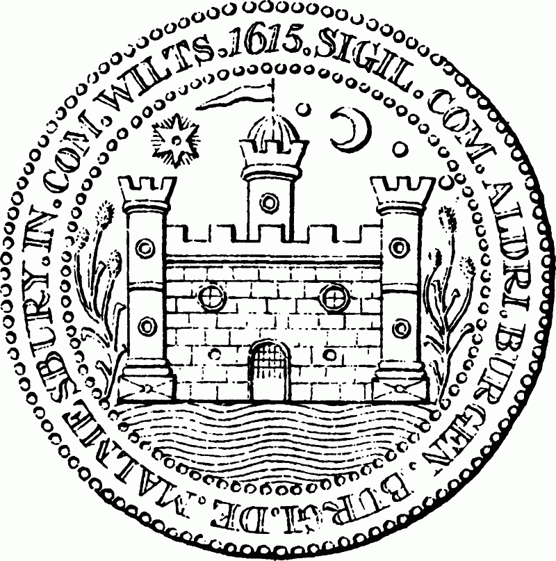
The borough seal, 1615
Courts and views held for Burton Hill manor were recorded with those for Rodbourne manor under the rubric of Cowfold manor with Rodbourne and Burton Hill for the years 1559, 1563–4, 1569, and 1571–3. The courts and views were held in spring and autumn yearly, probably at a house in Cole park. Between 1559 and 1564 and in 1573 views were held for Burton Hill at which a tithingman presented and a jury affirmed his presentments. Between 1569 and 1572 views were held jointly for Burton Hill and Rodbourne; there was a single jury but a tithingman from each presented. Burton Hill business included stray animals and overcharging by millers and a butcher. Courts baron for Burton Hill were held separately. The homage presented defaulters from the court, deaths of copyholders, and tenements in need of repair. The use of common pastures was regulated and, at the autumn court, a tithingman and a reeve were appointed. (fn. 622)
Courts leet and courts baron for Whitchurch and Milbourne manor are recorded for the years 1763–1816. The courts were usually held annually in autumn; additional courts were held to admit copyholders. At the autumn court two haywards, one each for Milbourne common and Whitchurch marsh, were appointed. Orders were made for footpaths to be repaired and, in 1766, a new pound to be built; encroachments on waste ground were presented. (fn. 623)
Parish government.
In 1632 those who lived in Cole park and West park were ordered to contribute to poor relief in the parish, (fn. 624) which was presumably administered without differentiating the town and the outlying parts. In 1636 it was reported that 60 houses within the precinct of the former abbey contained 47 persons needing relief; the implication was that the precinct was being treated as extraparochial but the parish should provide relief. Seven houses within the precinct were then in Westport parish. (fn. 625) Probably by 1760, however, and certainly by 1776 the Abbey had become a separate parish relieving its own poor. (fn. 626)
In 1642 £30 a week for six weeks was ordered to be collected from Malmesbury and parishes within 5 miles of it to relieve its poor, then affected by plague. Only £68 was collected and in 1646 the constables, churchwardens, and overseers were still seeking compensation for money spent during the epidemic. (fn. 627)
In the later 18th century the Malmesbury vestry set a rate and delegated its collection and the distribution of relief to 6 overseers, 2 for the town and 1 each for Burton Hill, Corston, Rodbourne, and Milbourne (presumably with Whitchurch). In 1779 John Chamberlain was appointed by the vestry to administer poor relief throughout the parish. From 1780, however, the six overseers again received and made payments. Relief in the parish, excluding Corston and Rodbourne, cost c. £150 in 1760–1. It was given regularly at a cost of £82 to 26 people; 22 apparently lived in the borough and 2 each in Milbourne and Burton Hill tithings. Occasional relief and other expenses cost £70; payments were made for clothing, bedding, rents, and funerals. In 1770–1 regular relief was given to 28 in the borough, 1 in Milbourne, and 3 in Burton Hill; in 1779–80 it was given to c. 40 in the borough, 6 in Milbourne, and 1 in Burton Hill. (fn. 628) In 1802–3 in Malmesbury parish, including Corston and Rodbourne, regular relief was given to 129 adults, some of whom were in the workhouse, and 168 children; 52 inhabitants and 107 people from outside the parish received occasional payments. The total cost was £972. During the next decade fewer people were relieved. In 1815 regular relief was given to 111 and occasional relief to 59. Costs, however, rose; £1,102 was spent on the poor in 1815. (fn. 629) A peak was reached in 1818 when £1,928 was spent. Thereafter expenditure fell until 1824, when £1,086 was spent, and usually remained between £1,000 and £1,200 until 1835 (fn. 630) when Malmesbury poor-law union was formed. (fn. 631)
In the later 18th century the east end of St. Paul's church housed some of the poor. (fn. 632) There was a workhouse in 1781, (fn. 633) which in 1803 had 46 inmates. (fn. 634) It was probably the building in Holloway held in 1805 by the churchwardens and overseers on a 21-year lease, (fn. 635) and may previously have been part of Jenner's almshouses. (fn. 636) In 1814 there were 23 inmates. (fn. 637) In 1825 a new poorhouse for the parish was built on the site of part of Jenner's almshouses at the junction of Oxford Street and Holloway; in 1834 the remaining almshouses also housed poor families placed there by the parish. (fn. 638) Such use presumably ceased when the union workhouse on the outskirts of the town in Brokenborough parish was opened in 1838. (fn. 639)
Poor relief in the Abbey parish cost £15 in 1775–6 and £30 in 1802–3, when four adults and four children were regularly relieved. Expenditure had risen to £50 by 1814, when seven people received regular relief. There is no record of occasional relief being given in the parish. (fn. 640) Between 1815 and 1835 the cost of poor relief was usually £35–£45; it was a little higher in 1816, 1820, and 1827–8, and lower in 1822–4. (fn. 641) The Abbey parish became part of Malmesbury poor-law union in 1835. (fn. 642)
Public Services.
Constables of Malmesbury were first recorded in the 1640s; it is not clear by whom they were appointed. In 1642 two constables complained to the justices at quarter sessions of the additional expense they had incurred during the plague of that year and in watching and warding, providing and mending arms, and attending and transporting prisoners. In 1644 a constable sought release from the office, in which he had served for three years apparently because manor courts had not been held. In 1646 a similar request was made by both constables, who claimed to have suffered great loss, particularly through plunder and imprisonment by royalist troops. (fn. 643) Between 1729 and 1741 two constables each for Malmesbury and Westport were appointed at the borough sessions, and from 1753 two constables for Malmesbury, two for Westport, and one for the Abbey parish at the manor court. Two sidesmen for Malmesbury and two for Westport were also sworn at the manor courts from 1753. (fn. 644)
From 1840 Malmesbury parish outside the borough was policed by the county constabulary. (fn. 645) The borough force was separate, presumably from c. 1840, until in 1887 it became part of the county constabulary. (fn. 646) A police station in the town belong ing to the county police in 1844 (fn. 647) was replaced in 1854 by a new building in Burnham Road. (fn. 648) A new station in Burton Hill was built c. 1955. (fn. 649)
The abbot of Malmesbury had a prison in the 12th and 13th centuries. (fn. 650) Prisoners were sent from the hundred courts to a gaol in Malmesbury in 1613, (fn. 651) and in 1682 the justices at quarter sessions ordered that a gaol be built there. (fn. 652) In 1831 a building east of the abbey gateway was used as the town prison. (fn. 653)
A fire brigade, formed in 1851, had a station in 1866, perhaps that in Ingram Street in use c. 1894. From 1907 to c. 1948 the brigade was based at the town hall. It was moved to a station in Gloucester Road c. 1948 and a new station was opened there in 1969. (fn. 654)
In 1798 an Act for paving the footways and for cleaning and lighting the streets of the borough (fn. 655) established a body of improvement commis sioners, and in 1872 the town became an urban sanitary district under the authority of the same body. (fn. 656) Its duties apparently passed to the borough council in 1886. (fn. 657)
In 1835 it was proposed to supply gas to the town; a gasworks north of St. John's bridge may have been built then (fn. 658) and was standing in 1848. (fn. 659) The Malmesbury Gas & Coke Co. was vested in the South Western Gas Board in 1949. (fn. 660) Electricity was supplied to the town by the Western Electricity Distributing Corporation in 1923. (fn. 661) The Malmesbury Water Works Co. Ltd. built a pumping house in Holloway in or soon after 1864 and a water tower south-east of Abbey House probably at the same date. The waterworks was transferred to the borough in 1900. (fn. 662) Another water tower, to serve Malmesbury rural district and the borough, was built north of Whychurch Farm between 1947 and 1953 (fn. 663) and was replaced by a new tower and pumping station in 1985. (fn. 664) In 1904 and 1920 proceedings were instituted by Wiltshire county council against the borough council to prevent the discharge of sewage into the Avon. (fn. 665) A sewage works was built north of Cowbridge Farm c. 1962. (fn. 666)
A cemetery and a mortuary chapel for Malmesbury and Westport parishes were opened on 1 ha. west of the Tetbury road in Westport in 1884. (fn. 667) A cottage hospital north of the market cross was opened in 1889 and rebuilt in 1897. It was transferred to the Manor House, Burton Hill, in 1925; (fn. 668) that house, much extended, was still used as a hospital in 1988. An isolation hospital was opened on a site then in Brokenborough parish c. 1890. It was a wooden building with 6 beds in 2 wards, but without cooking apparatus, bath-house, or bath. The hospital was closed in 1933. (fn. 669)
In 1851 a mechanics' institute in Malmesbury had 92 members and a library of 900 books. (fn. 670) A library in the town was open on two evenings a week in 1926, and in 1935 was in the town hall. Thereafter it was moved several times; from 1972 it occupied part of the former Malmesbury Church of England school in Cross Hayes. (fn. 671) In 1931 the Athelstan Museum was opened in the town hall. (fn. 672) It was moved to a building in Gloucester Road c. 1970 (fn. 673) but from 1979 was again in the town hall. (fn. 674)
Between 1931 and 1956 Malmesbury borough council built most of the new houses west of the town and the houses and prefabricated bungalows in Cowbridge Crescent. The council also built the swimming pool in Old Alexander Road opened in 1961. The Parklands estate was built for Malmesbury rural district council, (fn. 675) and North Wiltshire district council built the houses and maisonettes at Burton Hill. (fn. 676) In 1971 Wiltshire county council bought Burnham House as a residential home for the elderly, and later built the additional accommodation in its grounds. (fn. 677)
Parliamentary Representation.
Malmesbury returned burgesses to the parliament of 1275 and to a total of 74 parliaments before 1449; only New Salisbury, Wilton, and Marlborough of the boroughs in Wiltshire were more frequently represented. Until 1832 the borough usually had two M.P.s. The earliest surviving indentures are between the sheriff and the alderman and burgesses; in 1455 the borough's representatives were selected by the alderman and at least 13 burgesses. (fn. 678) The franchise had probably been restricted to the alderman and 12 other burgesses, later called the capital burgesses, by the late 16th century. The first record of an election by those 13 dates from 1640. (fn. 679) Conflicts over King's Heath and borough government in the early 17th century may have derived in part from attempts to extend the franchise, (fn. 680) but no complaint about electoral rights was recorded.
In the 15th century over half the borough's M.P.s whose names are known were residents of Malmesbury. In the mid 16th century leading clothiers were among the M.P.s. William Stumpe (d. 1552) sat in the parliaments of 1529 and 1547–52, and Matthew King in those of 1553–5 and 1558. (fn. 681) Sir James Stumpe was returned in 1555. A controlling interest in the borough's parliamentary elections apparently passed to Sir James's son-in-law Sir Henry Knyvett, who himself represented Malmesbury four times in the later 16th century, and later to Knyvett's son-in-law Thomas Howard, earl of Suffolk. (fn. 682)
For much of the 17th century at least one and sometimes both of Malmesbury's M.P.s were drawn from families with local interests: members of the Moody, Poole, Hungerford, Lee, Washington, and Estcourt families represented the borough. (fn. 683) Sir John Danvers, elected in place of Anthony Hungerford in 1645, was a signatory to Charles I's death warrant. (fn. 684) Elections were occasionally influenced by the earls of Berkshire, resident at Charlton Park, but more usually by members of the Danvers family and their heirs as lords of Malmesbury manor or by the holders of the post of high steward created by the borough charter of 1635. The high steward's influence presumably derived from his duty under the charter to advise the alderman and burgesses on all business concerning the borough. The post was held by members of the Estcourt family of Sherston Pinkney, in Sherston, between 1641 and 1659 and between 1671 and 1677. (fn. 685) Later high stewards were usually men of wider influence, often peers. (fn. 686)
A letter of 1684 refers to recent elections in Malmesbury as popular, but returns of that year do not indicate any increase in the number of electors. In 1689 Thomas Wharton, later marquess of Wharton and then lord of Malmesbury manor, took advantage of uncertainty over the borough charter to extend the franchise to assistant burgesses, landholders, and commoners; a total of 172 voted in the election of that year. (fn. 687) The old franchise was presumably restored in 1690 with the 1635 constitution of the corporation, and the franchise was not defined in the new charter of 1696. In the 1720s and 1730s a standard tariff, by which each of the 13 voters received £100 for a general election and £20 for the re-election of a member who had taken office, secured uncontested elections. In the mid 18th century Henry Fox (cr. Baron Holland 1763) and Henry Howard, earl of Suffolk and of Berkshire (d. 1779), competed for control of the borough. Fox, high steward from 1751 to 1760, proposed a compromise by which they shared both the representation and the electoral costs, paying each capital burgess a total of £30 a year and jointly providing for them two feasts each year. (fn. 688)
Lord Suffolk and his supporter Edmund Wilkins, a Malmesbury apothecary, were successively high steward 1762–9. Wilkins transferred his support to Fox and from 1769 to 1775 served as deputy high steward to Charles James Fox, who was M.P. for Malmesbury 1774–80. Wilkins was again high steward from 1775 to 1806. He controlled parliamentary elections by refining the system of annual pensions and reinforcing it by a bond of £500 entered by each capital burgess. Until 1789 he sold the borough at each election to the highest bidder; later he consistently supported government candidates. He was succeeded in control of the borough by Edmund Estcourt, who raised the pension to £50 yearly. Control of the borough's two seats was sold at least twice before 1832. The narrow franchise and the corruption and illiteracy of the burgesses were frequently attacked in the late 18th century and early 19th, and in 1796, 1802, 1806, and 1807 provided the grounds for petitions for elections to be overturned. The borough lost one seat in 1832, (fn. 689) and the remaining seat in 1884, when it was merged in the Chippenham division of the county. (fn. 690)
Churches.
In 1191 Malmesbury abbey was granted the right to appropriate the parish church, St. Paul's church 'in atrio monasterii', to endow lights in the abbey church. (fn. 691) By the mid 13th century a vicarage had been ordained. (fn. 692) Between 1650 and 1658 the vicarage was united with Westport vicarage (fn. 693) but the benefices were separated after 1660. (fn. 694) The vicarages and parishes were united under the name Malmesbury with Westport St. Mary in 1946, and in 1984 the new benefice and parish of Brokenborough was added. (fn. 695) Chapels at Corston and Rodbourne were dependent on St. Paul's church from the 14th century or earlier until 1881. (fn. 696)
The abbot of Malmesbury was patron of the vicarage presumably from its ordination and certainly from 1301. He presented at most vacancies until the Dissolution. The bishop of Salisbury may have collated a vicar in 1332, and in 1387 a vicar, who obtained the living by exchange, was apparently instituted without the abbot's consent. After the Dissolution the Crown presented (fn. 697) until 1866 when the advowson was sold to S. B. Brooke. (fn. 698) It passed with his Cowbridge estate to the Revd. Charles Kemble and to Charlotte Kemble (fn. 699) (d. 1890), who devised the advowson to her daughter Charlotte Kemble. (fn. 700) By 1907 the advowson had passed to the Church Trust Fund, (fn. 701) the patron of Malmesbury with Westport and Brokenborough in 1987. (fn. 702)
After a pension of £5 was paid to Malmesbury abbey the vicarage, worth £4 6s. 8d., was one of the poorer livings in Malmesbury deanery in 1291; (fn. 703) probably excluding a pension of £4 to the abbey, it was valued at £8 in 1535, close to the average for the deanery. (fn. 704) About 1830 the vicar's net annual income was £265, average for a Wiltshire living. (fn. 705)
Tithes, apart from those of grain and hay, were due to the vicar from the whole parish except some demesne of Malmesbury abbey. In the mid 13th century offerings and tithes owned by St. John's hospital were replaced by 40d. and ½ lb. wax a year. (fn. 706) In 1839 a total of 823 a., mostly what had been Cole park and West park, was tithe free; moduses totalling 12s. were paid in place of vicarial tithes from a further 185 a., said to be former demesne of the abbey. The vicar's tithes were then valued at £430 and commuted. (fn. 707)
The vicar had a house, perhaps in King's Wall, c. 1300; (fn. 708) it is not known whether it was part of the glebe. In 1412 Edmund Dauntsey and John Thornbury endowed the vicarage with a house and 5 a. (fn. 709) In 1671 the glebe comprised 3½ a., a cottage, and a house. (fn. 710) The house, of one bay in 1704, (fn. 711) stood in Gloucester Street opposite St. Paul's church. In the earlier 19th century it was used as a shop and vicars lived in lodgings. (fn. 712) From c. 1882 incumbents lived in a house, then newly built beside the Swindon road, belonging to Westport vicarage. (fn. 713) A new vicarage house was built in Holloway, and that beside the Swindon road was sold, in 1969. (fn. 714)
Its name suggests that Whitchurch may have been the site of an early chapel. Such a chapel may have invoked St. James in 1252, when Malmesbury abbey was granted a St. James's fair on its land at Whitchurch. (fn. 715) In 1535 offerings made from or at Whitchurch to an image of St. James were taken by the abbey. (fn. 716) Alms were distributed in a chapel at Whitchurch by the abbey or by the lessee of its Whitchurch estate at mass on the eve and feast of St. James in the early 16th century. (fn. 717) After the Dissolution presumably no service was held in the chapel, which from the 1560s or earlier passed with Whitchurch manor. (fn. 718) By 1670 it had been incorporated in Whychurch Farm. (fn. 719) In 1268 Nicholas of Malmesbury gave land at Fowlswick in Chippenham for a chaplain to say masses for his parents in the chapel of 'la Charnere' in Malmesbury. (fn. 720) No other reference to the chapel has been found. All Saints' chapel stood in High Street, perhaps on the eastern side, in the late 13th century and in 1545. (fn. 721) In 1544 the Crown granted a house called 'St. White's hermitage' at Burton Hill; (fn. 722) what, if any, ecclesiastical purpose the hermitage had before the Dissolution is not clear. In 1268 William Porter gave a rent of 1s. a year for a light in St. Paul's church. (fn. 723) A chantry was endowed at the altar of St. Mary in the church probably before 1300; (fn. 724) in 1388 the Crown presented a chantrist. (fn. 725) At the chantry's dissolution in 1548 its priest had an income of £6 11s. from Malmesbury and Westport and was described as a very honest poor man. (fn. 726)
Some parishioners apparently heard mass in the chapel of St. John's hospital until the mid 13th century, when attendance there was forbidden to all but those wearing the habit of the hospital. (fn. 727) In 1378 the vicar John Swan travelled to Rome for the sake of his conscience; (fn. 728) he resigned the living in that or the following year. (fn. 729) William Sherwood held the vicarage and a rectory in Oxford, and in 1477 was dispensed to hold a third living. (fn. 730) Richard Turner, vicar from 1535, in 1539 condemned the dissolution of the monasteries; (fn. 731) he seems to have suffered no penalty but had resigned the living by 1544. (fn. 732)
In the early 16th century parishioners may have attended services in the abbey church and St. Paul's fell into disrepair. In 1541 the nave of the church of the dissolved abbey was licensed as the parish church because St. Paul's had 'fallen even unto the ground'. (fn. 733) The former abbey church was then in the king's hand and in the keeping of William Stumpe. (fn. 734) In 1542 John Leland reported that the townsmen, among whom Stumpe was the chief contributor, had bought the church from the king. (fn. 735) Stumpe was probably then only the lessee of the site of the abbey; in 1544 he was granted the site by the Crown (fn. 736) and may then have given or sold the church to the parish.
There were said to be 860 communicants in Malmesbury and Westport parishes in 1548, and the Crown was then petitioned for assistant clergy to replace chantry priests who had formerly helped incumbents in both parishes. (fn. 737) John ApRice, vicar of Malmesbury from 1544 until c. 1564, had two other benefices and in 1556 no licence for plurality. (fn. 738) In 1551 the church had no copy of Erasmus's Paraphrases or Book of Homilies. (fn. 739) ApRice's successor John Skinner was deprived in 1564 or 1565, (fn. 740) for what reason is not known. In 1583 the vicar, James Steele, was alleged to have leased the vicarage and to have left the town. (fn. 741) In 1585, when he may still have been absent, the churchwardens complained that services were not held at the proper times and that there was no curate. (fn. 742)
In 1651 the alderman and burgesses granted to Robert Harpur, the vicar, rights of pasture on King's Heath as a mark of esteem. (fn. 743) In 1661 the bishop of Salisbury mentioned Malmesbury among places, whose incumbents were 'busy, turbulent' men, which he was unable to bring to good order; Simon Gawen was expelled from the vicarage in 1662. (fn. 744) Between 1643 and 1686 there were several cases of witchcraft in the town, (fn. 745) and Aubrey reported that seven or eight witches from Malmesbury were hanged in the 1670s. (fn. 746)
Vicars of Malmesbury received 20s. a year from each of three annual sermon charities, founded by Michael Wickes, Elizabeth Hodges, and Robert Cullerne in 1695, c. 1723, and in 1758 respectively. No payment was received from Hodges's charity in or after the late 19th century, (fn. 747) but payments from Wickes's and Cullerne's were still made in the late 20th. (fn. 748)
John Copson, vicar 1749 to c. 1786, was from 1765 also vicar of Kemble (now Glos.). (fn. 749) In 1783 he lived at Kemble and a curate, who was also curate of Ashley (now Glos.), served Malmesbury, including Corston and Rodbourne chapels. Services were then held at Malmesbury on Sunday afternoons and additionally at festivals and in Lent. Communion was celebrated four times a year and there were usually c. 50 communicants. (fn. 750) From 1879 until the benefices were united Malmesbury and Westport vicarages were held in plurality. (fn. 751)
ST. PAUL'S church was so called in 1191. (fn. 752) In 1542 all that remained of it was the west tower, then used as a house, and part of the east end, used as a town hall. (fn. 753) Reports in 1556 and 1585 that a church in Malmesbury needed repair (fn. 754) may refer to St. Paul's and, if they did, indicate some hope of its restoration as the parish church. Part of it may have continued in ecclesiastical use until the 1630s; there were said to have been marriages and sermons at St. Paul's until then. (fn. 755) The east end was probably used for meetings of the corporation until the 18th century, (fn. 756) and in the late 18th century was apparently a poorhouse. (fn. 757) When it was demolished in 1852 it was said to have long been used as a timber warehouse. (fn. 758) The tower was standing in 1988 and then as earlier housed bells rung for services in the abbey church. (fn. 759) It was built in the 14th century, of limestone rubble with ashlar dressings, and has three stages.
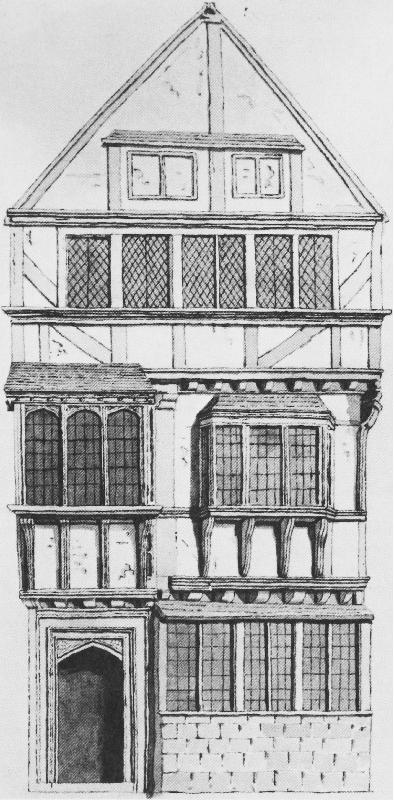
The vicarage house in 1790
Before the Dissolution the abbey church (fn. 760) was apparently dedicated to St. Mary and St. Aidhelm. (fn. 761) In the early 20th century an additional or alternative dedication was to ST. PETER AND ST. PAUL. (fn. 762) In 1988 all four saints were invoked. (fn. 763) Nothing survives of the churches and other buildings of the abbey which stood before the 12th century. (fn. 764) Parts of the crossing, transepts, and nave (fn. 765) of the 12th-century church survive and footings found by excavation indicate a semicircular ambulatory at the east end. The surviving parts suggest that the church had arcades, a triforium, a clerestory, and a timber roof, and that the whole was built to one design in the later 12th century. The arcades were of nine bays and the transepts each of three bays; chapels probably extended eastwards from the outer bay of each transept. (fn. 766) The south doorway and porch were richly decorated with stone sculptures representing the apostles and scenes from the Old and New Testaments. (fn. 767) The cloister was to the north and was probably surrounded by other buildings although only one wall, to the east and presumably part of the chapter house, has been traced. Because the ground falls steeply north of the cloister, the dormitory and its undercroft seem likely to have run east—west. The vaulted 13th-century undercroft incorporated in Abbey House (fn. 768) may have been at the end of or beside the dormitory range. Another probably 13th-century range, incorporated in the Old Bell hotel west of the church, (fn. 769) may have been part of a building which, according to the usual plan of a monastery, consisted of the inner gatehouse and the abbot's lodging. By the 16th century, however, the abbot's lodging was apparently south-east of the church. Late 13th-century improvements and additions included alterations to the chapter house and the building of a new infirmary; (fn. 770) neither building survives. In the early 14th century the nave and transepts were vaulted and the clerestories altered and, at the west end, rebuilt. Flying buttresses were added to the nave to support the vault, the parapets of the nave and aisles were reconstructed, and the porch walls were made thicker, perhaps to support a tower. A first-floor room, but no tower, was built over the porch. A tower was built over the two western bays of the nave c. 1400. A central tower, perhaps built in the 12th century, was apparently heightened and topped with a tall spire of wood and lead in the later Middle Ages. It fell probably in the early 16th century. (fn. 771) The west tower was standing in 1660 but fell soon afterwards, destroying the south-west corner of the nave. (fn. 772) When the nave became the parish church a wall was built between it and the crossing. After the west tower fell a wall was built across the nave three bays from the west end. That wall had a window with wooden tracery which in 1823 was replaced by one in stone made to designs by H. E. Goodridge. A plaster vault, presumably imitating the surviving 14th-century vaulting, was then built over the western bays of the nave and a gallery and an organ were built against the west wall. (fn. 773) Major alterations since then include the extension of the south aisle and clerestory in 1900, (fn. 774) the vaulting of the porch in 1905, (fn. 775) and the restoration of the upper room in 1912. (fn. 776) Between 1926 and 1928 the plaster part of the nave vault was renewed in stone and the gallery was removed. (fn. 777)
A chalice valued at 40s. was stolen from St. Paul's church in 1383 or 1384; (fn. 778) no other record survives of plate used in that church. Chalices of 1575 and 1631, the latter given in 1632, and a paten of 1702 belonged to the parish c. 1890. (fn. 779) That plate, a chalice of 1703, and other plate mainly of the late 19th century and the 20th, some from Westport church, belonged to the parish in 1988. (fn. 780)
In 1987 eight bells hung in the tower of St. Paul's. The oldest was one cast in Bristol c. 1500; one of 1610 was cast by a member of the Purdue family. A bell of 1640, perhaps cast by A. Hughes, and one of 1703 by William Cor were recast by Mears & Stainbank in 1910, and a bell of 1739 was recast in 1896 by Llewellins & James. Three new bells were cast in 1951 by Gillett & Johnston. (fn. 781)
Registers of baptisms, marriages, and burials survive from 1591. (fn. 782)
Roman Catholicism.
In 1865 a site in Cross Hayes was bought for a Roman Catholic church, (fn. 783) which was in the charge of Missionaries of St. Francis de Sales from 1867. (fn. 784) By 1876 that church had been replaced by a new stone building in a plain 14th-century style. (fn. 785) The former church was used as a school from 1876 or earlier until c. 1932. (fn. 786) By will proved 1923 C. J. Pollen gave the income from an invested sum, then £22 yearly, for the use of a Roman Catholic priest in Malmesbury. (fn. 787)
Protestant Nonconformity.
Simon Gawen, ejected from Malmesbury vicarage in 1662, preached in the town until his death in 1672. (fn. 788) Other dissenting ministers in the town in the late 17th century included Henry Chandler, a Presbyterian recorded there in 1687, (fn. 789) and Samuel Clifford, formerly rector of East Knoyle, who preached in Malmesbury between 1695 and 1699. (fn. 790) Until the late 18th century nonconformity in the town was concentrated in the Westport part. In 1676 there were 5 nonconformists in Malmesbury, 18 in Westport; (fn. 791) in 1715 a Presbyterian minister in Westport was said to serve a congregation of 160; (fn. 792) and in 1783 the curate of Malmesbury reported that there were many dissenters of various denominations in the parish, but that their teachers lived elsewhere, (fn. 793) presumably in Westport.
An Anabaptist parishioner of Malmesbury refused to allow his child to be baptized in 1660 (fn. 794) and in 1672 a house in Malmesbury may have been licensed for Baptist meetings. (fn. 795) A chapel was built in Westport parish, in Abbey Row on the boundary with Malmesbury parish, in or before 1695 and another built on the same site for Strict Baptists in 1802 was open in 1987. (fn. 796)
Several Quaker families lived in Burton Hill between 1669 and 1750. (fn. 797) A house in Malmesbury parish, probably in Burton Hill, was certified in 1695 for Quaker meetings. (fn. 798) A Quaker Sunday school was opened in Malmesbury in 1827, and in 1833 had 50 pupils, (fn. 799) but there is no record of a meeting in the town.
Between 1739 and 1741 John Wesley preached three or four times in Malmesbury. (fn. 800) John Davis (d. 1796), chaplain of Lea and Cleverton and curate of Garsdon, held evangelical services in a cottage in the town (fn. 801) and some of his congregation may have become Methodists c. 1800. (fn. 802) In 1814 and 1825 Primitive Methodists met in the former Ebenezer chapel in Silver Street, (fn. 803) but they had no permanent church in the town until 1856 when a chapel was built in Bristol Street in Westport parish. (fn. 804) A chapel in the Triangle in Westport was open in 1987. Wesleyan Methodist services were held in the town hall from 1882 to 1886, when a chapel was opened in Cross Hayes. (fn. 805) The chapel had been closed by 1919. (fn. 806)
In 1745 John Cennick, a follower of George Whitefield, invited the Moravian Brethren to take charge of congregations in north Wiltshire founded by his preaching, including one in Malmesbury. (fn. 807) A Moravian church may have been in the town since 1742. (fn. 808) In 1770 a chapel was built near the junction of Oxford Street and Cross Hayes Lane. On Census Sunday in 1851 morning service was attended by 96 adults and 51 children; 122 adults attended evening service and a school was held in the afternoon. (fn. 809) The chapel was open in 1987. Registers of births and baptisms for the years 1827–40 and of burials 1826–40 survive. (fn. 810)
A cottage in Malmesbury certified in 1792 for Independent meetings (fn. 811) may have been used for John Davis's evangelical services. (fn. 812) Before 1800 two cottages in Silver Street were converted for use as the Ebenezer chapel by all or part of his congregation. In 1812 the congregation was united with that of Westport Congregational church, formerly the Presbyterian or Independent chapel, and the Ebenezer chapel was sold soon afterwards. A new meeting house was opened in Silver Street as a branch of the Westport church in 1836, and from 1841 was a separate church. The building was enlarged or rebuilt in 1848. On Census Sunday in 1851 the three services in the chapel, again called the Ebenezer chapel, were each attended by a congregation of between 150 and 200; attendance was said to be lower than usual. (fn. 813) In 1914, because there was no settled minister, it was proposed to reunite the chapel with Westport Congregational church; the proposal was resisted by the Silver Street deacons, (fn. 814) apparently successfully. The chapel had been closed by 1974. (fn. 815)
Other meeting houses in Malmesbury were certified in 1825 and 1827, and in 1842 a hall was certified. (fn. 816) From 1948 meetings of an Assemblies of God Pentecostal church were held in the town; the church occupied a building in Silver Street from 1967 and was open in 1987. (fn. 817)
Education.
A school may have been opened in the former hospital of St. John after the building was acquired by Malmesbury corporation in 1580. (fn. 818) The agreement of 1609 concerning the borough's government required that, of £20 paid annually by the alderman and burgesses for their inclosures on King's Heath, £10 should be paid to a schoolmaster. (fn. 819) From 1629 or earlier the payment was in the form of a rent charge on some of the inclosures. (fn. 820) The payment was confirmed by the borough charter of 1696. In 1695 Michael Wickes endowed the schoolmaster with an additional £10 a year from land in Great Somerford. (fn. 821) The school was apparently held in the part of the former hospital also used as a court room. (fn. 822) Instruction was free; in 1714 a master was dismissed for leaving the town and appointing a deputy who demanded fees. (fn. 823) There were 25 pupils in 1818, (fn. 824) and in 1858, when 50 pupils attended in wet weather and 20 in fine, the school was described by its master as little better than a refuge on a wet day. (fn. 825) In the late 19th century the school was attended only by sons of members of the corporation or freemen of Malmesbury. It was closed in 1890 and the warden and freemen of Malmesbury gave the rent charge to the National school provided that it accepted 20 sons of freemen. Payment of the rent charge to the school ceased on introduction of free elementary education in 1891. (fn. 826) Under a Scheme of 1910 the rent charge provided exhibitions at secondary schools or technical institutions for boys and girls resident in Malmesbury, preferably the children of freemen. (fn. 827) After 1890 occasional payments were made from Wickes's charity to schools in the town. (fn. 828)
In 1634 Robert Arch gave 11 a., mostly in Lea and Cleverton parish, for the general good of Malmesbury borough. (fn. 829) In 1818 the income of £55 was used for a school attended by c. 150 pupils. (fn. 830) By 1834 the income had fallen to £33. It then paid for a free school for 45 girls held in a room over the porch of the abbey church; lace making was among the subjects taught. (fn. 831) The school was open in 1873 (fn. 832) but apparently closed soon afterwards. In 1908 the endowment was used for Malmesbury and Westport church schools, (fn. 833) and in 1911 provided scholarships for pupils from the town attending secondary schools. (fn. 834)
By will dated 1723 Elizabeth Hodges gave £30 yearly to schools in Malmesbury and other bequests to schools in nearby parishes. The provisions of the will were executed in 1730 when a Chancery decree ordered the foundation of a school for 15 boys. (fn. 835) The school's income and the number of its pupils were unchanged in 1846. (fn. 836) In 1869 the school was amalgamated with Westport Church of England school. (fn. 837) A Scheme of 1915 provided that the endowment should promote the education of children in the town by the award of exhibitions or other means. The annual income was between £10 and £15 in the 1960s. (fn. 838) In 1987 a share of the £67.50 given by the charity was received by schools in Malmesbury. (fn. 839)
A school for Malmesbury and Westport parishes was built in or before 1851 beside Sherston Road on a site then said to be in Westport parish, (fn. 840) but probably that in a detached part of Bremilham parish on which additional buildings, including a teacher's house, were erected in 1855–7. In 1857 it was attended by 63 boys and 34 girls. (fn. 841) From 1859 Westport Church of England school was a National school for boys only, (fn. 842) and in 1872 there were 247 pupils. (fn. 843) Another Church of England school for Malmesbury parish, built in 1857 in Cross Hayes, was for girls and infants. (fn. 844) In 1858 it had 220 pupils. (fn. 845) Average attendance at the two schools totalled 471 in 1909–10, 301 in 1921–2. (fn. 846) Both were closed in 1964 when a new primary school was opened in the old grammar school in Tetbury Hill. (fn. 847) A new school was built on the Tetbury Hill site in 1983; in 1988 it had 290 pupils on roll. (fn. 848)
A secondary school was opened in the town hall in 1896. It moved to new buildings on the west side of Tetbury Hill in 1903. (fn. 849) As Malmesbury grammar school it was attended by c. 240 in 1948. (fn. 850) A new school was built 750 m. north of it in 1964. A secondary modern school was built north of Sherston Road in Brokenborough parish in 1954; (fn. 851) it then had 450 pupils. The buildings of that school, the grammar school, and Westport Church of England school were used by a comprehensive school known as Malmesbury school from 1971; in 1988 it had 809 pupils on roll. (fn. 852)
The Roman Catholic school, built in Cross Hayes in 1869, (fn. 853) using the former church by 1876, (fn. 854) run by Sisters of St. Joseph of Annecy from 1884, (fn. 855) was known as St. Joseph's school. In 1892 average attendance was 60; (fn. 856) numbers changed little before 1922. (fn. 857) A new school was built in Holloway in 1932–3; it had c. 90 pupils in 1935–6. (fn. 858) In 1988 there were 98 children on roll from Malmesbury, Brinkworth, Hullavington, Crudwell, and Sherston. (fn. 859)
Other schools in the town included one kept by J. M. Moffatt (d. 1802), minister of Westport Presbyterian chapel, (fn. 860) and one held by the three daughters of Thomas Milsome in 1806. (fn. 861) In 1830 there were five and in 1842 seven schools in addition to the endowed schools in the town; most were probably in Westport parish. They included two ladies' boarding schools in 1830; in 1842 one was in Burton Hill. (fn. 862) Burton Hill House was used as a private school during the Second World War. Since 1945 it has been a residential school for physically handicapped children. In 1987 there were 32 pupils. (fn. 863)
Charities for the Poor.
From 1584 the alderman and burgesses were using the former hospital of St. John as an almshouse and possibly a school, (fn. 864) and from 1609 they gave £10 of the £20 paid for their inclosures on King's Heath to maintain five inmates of it; from 1629 or earlier the £10 was a rent charge on particular inclosures, (fn. 865) and in 1696 its payment was confirmed by the borough charter. From 1695 the almshouse also received £10 a year from Michael Wickes's charity. In the early 20th century it comprised three cottages, providing accommodation for six widows of freemen of Malmesbury. (fn. 866) Between 1927 and 1967 it was rarely full and was sometimes empty. It was converted to house three people and filled in 1967. (fn. 867)
In 1612 Thomas Cox gave the income from 40s. to be distributed to the poor of Malmesbury on Good Friday annually. (fn. 868) Nothing more is known of the bequest. In 1641 Robert Jenner built almshouses near the corner of Oxford Street and Holloway for eight people. (fn. 869) In 1643 he gave a rent charge of £40 from Widhill manor in Cricklade for their upkeep and by will dated 1651 provided for the payment to continue. In the later 17th century and the early 18th actions were brought against his heirs for failure to pay the rent charge; payment ceased before c. 1740. Four of the almshouses were demolished in 1825 and the remainder in the later 19th century. (fn. 870)
In 1654 Henry Grayle gave a rent charge of £10 yearly from lands in Great Somerford to apprentice poor children of Malmesbury. In the 19th century two children were usually apprenticed each year. Three boys were apprenticed in 1904; beneficiaries were usually from the borough but sometimes from St. Paul Malmesbury Without. (fn. 871)
E. Waite (d. 1661) gave by will £3 a year to the poor of the borough and Burton Hill. By a deed of 1774 Anne Rowles gave two thirds of the income from £100 to the poor of Malmesbury parish. In the 1830s the income from the two charities was distributed together; each beneficiary received 6d. In 1904 Waite's charity was distributed separately; adults received 6d. each and children 3d. (fn. 872) No record has been found of payments after 1910. (fn. 873) By a Scheme of 1907 Rowles's charity was united with that of William Arnold. The combined income, then c. £17, was thereafter used to buy coal for elderly residents or widows in the borough and Burton Hill. (fn. 874) In the later 20th century the income was allowed to accumulate and few payments were made. (fn. 875)
In 1695 Michael Wickes gave the income from lands in Great Somerford for charitable purposes in Malmesbury, including payments to St. John's almshouse, the free school, and the vicar of Malmesbury. The residue was to be distributed as the trustees thought fit. There was apparently little residue until the school was closed in 1890. (fn. 876) Thereafter the money was given to other Malmesbury institutions; in 1914 recipients of a total of £68 included the cottage hospital, the lying-in society, and the mayor's coal fund. (fn. 877)
Benefactions under the will of Elizabeth Hodges, dated 1723, included £10 yearly for poor housekeepers of Malmesbury. From 1820 equal payments were made to 20 of the second poor; beneficiaries were nominated for life. Similar payments were made in 1904. (fn. 878) The charity's income remained c. £10 in 1960. (fn. 879) In 1987 payments totalling £175 were made to poor residents of Malmesbury and of three other parishes named in the founder's will. (fn. 880)
By a deed of 1758 Robert Cullerne gave £17 10s. of a rent charge of £20 from lands in Lea and Cleverton to be given to the poor of Malmesbury (presumably the borough), of Burton Hill, and of Westport; each family was to receive 5s. annually. In 1904 payments were probably to individuals and each received 2s. 6d., (fn. 881) in 1975–6 payments of 25P each were made to 87 applicants, (fn. 882) and similar payments were made in 1987. (fn. 883)
By will dated 1778 William Arnold gave the income from £400 to buy bread for the poor of Malmesbury. In 1904 the income, £14 8s. 4d., was used to buy bread for the poor of the borough and Burton Hill. (fn. 884) By a Scheme of 1907 the charity was united with that of Anne Rowles. (fn. 885)
May Moore (d. 1978) gave by will a house in Abbey Row and £10,000 to house and care for the elderly. In 1983 it was declared that the endowment should be used to provide grants, clothing, or travel for elderly residents within the boundaries of the former borough, and that an administrator should occupy the house. The yearly income was then c. £1, 300. (fn. 886)
CORSTON
Corston was a village, chapelry, and tithing in the south-western corner of Malmesbury parish. In 1839 its lands measured c. 1,140 a. (461 ha.). (fn. 887) They may have been those of a 10-hide estate beside the 'Corsaburna', later called Gauze brook, (fn. 888) apparently the subject of a grant in 701, (fn. 889) In 1086 Corston was part of Malmesbury abbey's large estate called Brokenborough. Corston's boundaries had apparently been fixed by c. 1100 when all except its northern one were surveyed with others of the Brokenborough estate; they may have been roughly those of c. 1840, when the northern boundary was a little north of Gauze brook, but few landmarks on them c. 1100 can now be traced. (fn. 890) In the later 13th century Corston was apparently part of the abbey's Cowfold estate, (fn. 891) but later may again have been a separate estate; possibly in the 12th century, certainly before 1341, a church was built there. (fn. 892)
In 1377 there were 46 poll-tax payers in Corston, a little below average for a place in Malmesbury hundred, (fn. 893) and Corston was of below average prosperity in the late 16th century. (fn. 894) Its population rose rapidly in the early 19th century, from 127 in 1801 to reach 171 in 1821 and 322 in 1851, (fn. 895) but had fallen to 304 by 1881, (fn. 896) Numbers increased again in the mid and late 20th century when married quarters were built for R.A.F- Hullavington and private and local authority houses were built in Corston village. (fn. 897)
The village lies beside Gauze brook at the north end of the chapelry. Its early focus may have been around a green where a road from Rodbourne joins the Malmesbury—Chippenham road; the church stands on rising ground in the north-eastern angle of the junction. In the early 18th century settlement extended north along the Malmesbury road to Gauze brook and Corston Mill, south to the farmstead later called Manor Farm, and east along the Rodbourne road to the farmstead later called Firs Farm. (fn. 898) Surviving buildings of that or earlier date include the possibly 17th-century Manor Farm, two stone cottages of 17th-century origin east of the main road, and the Hermitage, a 17thcentury stone house south of the church. Only a few 18th-century cottages survive; some were rebuilt in the 19th century. The Radnor Arms west of the road was built and opened as an inn in the 1790s. (fn. 899) Firs Farm was largely rebuilt in the 19th century. The southern and eastern limits of the village remained unchanged until the 20th century. By 1828 settlement had spread north of Gauze brook to and beyond the boundary of the chapelry, mainly on the west side of the Malmesbury road. (fn. 900) There Newlands Cottage bears the date 1825; north of it Newlands Farm and Quarry House replaced other buildings in the later 19th century. The Bell inn, which stood west of the main road north of Gauze brook in 1881, had closed by 1899. (fn. 901) North of Gauze brook settlement also spread along Mill Lane in the mid and later 19th century when cottages and a nonconformist chapel were built west of the mill. (fn. 902) The Mill inn was open in 1910 (fn. 903) and closed c. 1965. (fn. 904) Another chapel was built west and the vicarage house north of the church in the late 19th century; a reading room was built north-west of the church in 1904. (fn. 905) In 1933 three pairs of council houses were built 350 m. south-west of Manor Farm; (fn. 906) in the later 20th century a garage, on the site of a small group of gabled 17th-century cottages demolished in the 1960s, (fn. 907) and Kingway View, a row of bungalows, was built north of them. In the 1950s 22 council houses were built beside the Rodbourne road. Manor Park, a private estate of eight houses and bungalows, was built north-east of Manor Farm in the 1970s. Elsewhere in the village there has been infilling in the late 20th century. The bridge carrying the Malmesbury-Chippenham road over Gauze brook was rebuilt in 1984. (fn. 908)
There was no substantial building in the chapelry outside the village in the early 18th century. (fn. 909) By 1773 a farmstead called the Bell had been built beside the boundary with Stanton St. Quintin south-west of the village. Another, Kingway, was built east of the Chippenham road south of the village between 1773 and 1828. (fn. 910) After its land was acquired for Hullavington airfield in 1935 Bell Farm was demolished and houses and other buildings for R.A.F. Hullavington were thereafter built on and around its site. They include 62 houses in Anson Place built in 1935–6 and 1948–9. In addition to the buildings the main north-east and south-west runway was built on the 115 ha. of Corston in the station, which also had land and buildings in Stanton St. Quintin and Hullavington. (fn. 911) Hangar Farm was built east of the Chippenham road near the airfield between 1959 and 1974. (fn. 912) The Plough, a small 19th-century stone building beside the Rodbourne road, was open as a public house in 1885; (fn. 913) it was closed in 1964. (fn. 914)
Manor and other Estates.
Corston seems to have been the 10-hide estate beside Gauze brook apparently granted by King Ine to Malmesbury abbey in 701. (fn. 915) Six hides in Corston, presumably the whole estate, were held of the abbey by Ranulph Flambard in 1086, (fn. 916) but later the abbey had no tenant in demesne. Corston passed to the Crown at the Dissolution (fn. 917) and in 1564 the manor of CORSTON was sold to Thomas Chadderton (fn. 918) (fl. 1567). (fn. 919) In 1569 it was bought from Thomas's creditors by his cousin William Chadderton, (fn. 920) who sold the lordship and most of the lands in 1573 to Sir Walter Hungerford. (fn. 921) Sir Walter (d. 1596) (fn. 922) was succeeded by his halfbrother Sir Edward Hungerford (d. 1607), (fn. 923) whose relict Cecily, from 1608 wife of Francis Manners, from 1612 earl of Rutland, may have retained the manor until her death in 1653. (fn. 924) It was inherited by Sir Anthony Hungerford (d. 1657) and by his son Sir Edward, (fn. 925) who in 1682 conveyed the manor to his uncle Sir Giles Hungerford. (fn. 926) From Sir Giles (d. 1685) it passed like Stanton St. Quintin manor to his relict Margaret, to his son-in-law Robert Sutton, Baron Lexinton, and in the Bouverie family and with the viscountcy of Folkestone and the earldom of Radnor to Jacob, earl of Radnor (d. 1930). (fn. 927)
In 1905 Lord Radnor sold Manor farm, c. 330 a., (fn. 928) probably to David Roberts, the owner in 1910 (fn. 929) and 1912. (fn. 930) The farm was sold again in 1919, (fn. 931) and in 1927 belonged to Frank Sage. (fn. 932) In 1951 it was offered for sale as Manor farm, 155 a., and South Side farm, 143 a., by W. S. Tyler. (fn. 933) Since then those lands have been owned by members of the Eavis family, who held Manor farm, c. 330 a., in 1987. (fn. 934) Between 1910 and 1912 Lord Radnor sold Bell farm, 401 a., and 146 a., part of Lower Stanton farm based in Stanton St. Quintin, to Meredith Meredith-Brown (d. 1920), whose estate was broken up c. 1920. In 1919 or 1920 S. H. Jones bought Lower Stanton farm and 116 a. of Bell farm. Half those lands descended to his son Mr. S. Jones (fn. 935) who sold them as Hangar farm, 217 a., in 1989. (fn. 936) F. J. Huntley bought Bell farm in 1920, and in 1935 sold it to the state for Hullavington airfield. (fn. 937)
In 1575 William Chadderton sold the rest of Corston manor, c. 130 a. and rights of pasture, to Thomas Richman (fn. 938) (fl. 1576). (fn. 939) That estate was held c. 1580 by John Richman (fn. 940) (d. 1615), who was succeeded by his daughter Margaret, wife of Edmund James (d. 1620). (fn. 941) From Margaret (fl. 1664) it passed to her son Edmund James (d. by 1675) whose relict Anne married William Cole c. 1677. From Elizabeth, wife of Francis Goddard and a descendant of Margaret James's younger daughter, Cole bought the reversion of a moiety in 1691, and from Edward Brown, grandson of Margaret's elder daughter Margaret, he bought the reversion of the other in 1700. The manor descended with Bradfield manor in Hullavington to Cole's daughter Anne Cale and to her daughter Anne, wife of the Revd. Anthony Whistler (d. 1719). The Whistlers' son John (fn. 942) sold it in 1771 to William, earl of Radnor, (fn. 943) and it was reunited with the manor.
The rectorial tithes from Corston were due to Malmesbury abbey, passed to the Crown at the Dissolution (fn. 944) and were probably all granted in 1606 to Laurence Baskerville, William Blake, and Roger Rogers, (fn. 945) perhaps for a member of the Bridges family. In 1622 John Bridges conveyed the tithes to Robert Bridges and his wife Elizabeth, (fn. 946) and in 1653 they were settled on Richard Bridges and his wife Eleanor. Richard was apparently succeeded in turn by his son George and by George's son George, who in 1731 sold the tithes to Richard Bromwich. By will proved 1753 Bromwich gave them to his wife Susannah (d. 1764), who devised them to her nephew John Melhuish. In 1791 Melhuish sold them to R. H. Gaby and Walter Gaby (d. c. 1811) (fn. 947) and in 1822 R. H. Gaby sold them to Jacob, earl of Radnor. (fn. 948) Thereafter they were merged. (fn. 949)
Economic History.
In 1086 Ranulph Flambard's estate had land for 5 ploughteams, but only 3 teams worked it; 2 villani and 2 coscets had 2 teams, and 2 servi and a third team were apparently on the demesne. There were 10 a. of meadow, 15 a. of pasture, and woodland 3 furlongs long and 1 furlong broad. (fn. 950)
Customary tenants may have cultivated much of Corston's land in the late 13th century. (fn. 951) In the late 16th century almost two thirds of the lands were arable. There were fields called Ham, Up, and Broad lying respectively east, south, and west of Corston village. Another, West field, was in the south-west corner of the chapelry; the location of a fifth field, Old Lands, is not known. Most were presumably open fields, but all or part of Up field had been inclosed by the earlier 15th century. Most of the pasture lay in the south and beside the western boundary; there was presumably meadow land beside Gauze brook. Only c. 100 a. of pasture were common, and c. 200 a. of meadow and pasture were in closes; c. 60 a. of pasture, probably near the boundary with Hullavington, had been inclosed by the early 16th century. The tenants of both parts of Corston manor shared the common pasture; some also had grazing rights on 60 a. of King's Heath. (fn. 952)
The farm sold to Thomas Richman in 1575 was in 1574 a holding of 3 yardlands, including 34 a. of several pasture of which 12 a. had recently been inclosed, 90 a. of arable in the open fields, 6 a. of meadow, and rights of common pasture. (fn. 953) By 1691 most of the farm's arable had been converted to c. 160 a. of several pasture. (fn. 954) The copyholders of Corston owed cash payments instead of services of cutting and carrying hay from three meadows in Cole park, (fn. 955) and had earlier owed works of ploughing in Kemboro field in Burton Hill. (fn. 956) A leasehold comprised 98 a., including 80 a. of arable. (fn. 957)
By 1720 all Corston's lands had been inclosed. (fn. 958) Some were still copyhold in the late 18th century (fn. 959) but the larger holdings were probably leasehold. In 1800, by which date the two portions of the manor had been reunited, there were two large farms, of 354 a. and 409 a., and five of between 20 a. and 60 a. each. (fn. 960) In 1839 Manor farm was 484 a., mainly in the north, and Bell farm was 455 a., mainly in the south. The chapelry was then half arable and half pasture; most of the arable was in the south and centre. There were 16 a. of wood beside the boundary with Rodbourne. (fn. 961) Coarse heath, 17 a. lying 700 m. south of the village, was worked as 60 allotments in 1834, (fn. 962) but not in 1839. (fn. 963) Pasture in Corston was used principally to graze sheep in the mid 19th century; there were over 1,100 in 1866. (fn. 964) In 1910 most of the land lay in four farms, Manor, 308 a., Bell, 401 a., Newlands, 119 a., and one of 146 a. (fn. 965) Manor farm was mainly pasture in the early 20th century. (fn. 966) It was later worked as two farms, in 1951 as Manor, 155 a., and South Side, 143 a., respectively northwest and south-east of the Malmesbury—Chippenham road. Both were mixed farms; there was more arable than pasture on Manor farm, more pasture than arable on South Side farm. (fn. 967) Thereafter the lands were again worked as a single farm. In 1987 Manor farm was a mixed holding; there was a dairy herd of 200, and wheat and barley were grown on c. 300 a., some of it in Hullavington parish. (fn. 968) Bell farm had been divided into holdings of 116 a. and 285 a. by 1927. (fn. 969) The larger portion, west of the Malmesbury—Chippenham road, went out of agricultural use in 1935. (fn. 970) The smaller, east of the road, was part of Lower Stanton farm; later, as part of Hangar farm, it was worked from a reused hangar. (fn. 971)
There was a mill at Corston in 1086 (fn. 972) and 1539. (fn. 973) A mill on Gauze brook was part of Corston manor in 1810. (fn. 974) It and the mill house were rebuilt in the early 19th century. The mill ceased working c. 1899. (fn. 975)
Stanton brickworks, east of the MalmesburyChippenham road 500 m. north of the boundary with Stanton St. Quintin, was probably open in 1861 and certainly in 1885; it was closed in the early 20th century. (fn. 976)
In 1834 there was a quarry, presumably for limestone, north of Corston church, and another at the north end of the village; (fn. 977) both had apparently been closed by 1885. Two more quarries were at the north end of the village, and another south of the brickworks, in 1899. By 1921 one of the quarries in the village had been closed. (fn. 978) The other and that near the brickworks remained open in 1927 (fn. 979) but were disused in 1987. (fn. 980)
Local Government.
In the early 16th century and perhaps until the sale of the manor by the Crown in 1564, courts for Corston were held at a house in Cole park. (fn. 981) In 1561–2 the Crown held views of frankpledge and manor courts in spring and autumn. (fn. 982) Between 1712 and 1742 courts baron were usually held annually, in spring until 1718 and in autumn thereafter. From 1720 leet business was also transacted. A tithingman was appointed and the homage presented buildings to be repaired, watercourses to be cleaned, and the deaths of copyholders. (fn. 983) No court is recorded after c. 1790. (fn. 984)
Corston did not relieve its own poor, but in the later 18th century and the early 19th an overseer was appointed to deal only with Corston. In 1760–1 two people received regular relief totalling £7; occasional relief and other extraordinary costs amounted to £3. The number regularly relieved had risen to six by 1770–1, and £39 was spent on the poor in 1780–1. (fn. 985)
Church.
The shape of Corston church before it was rebuilt in the 19th century suggests that it was built in the 12th century. (fn. 986) A church at Corston may have been served from Malmesbury abbey until a vicarage of Malmesbury was ordained between 1191 and the mid 13th century, but none is recorded until 1341 when there was a chapel dependent on Malmesbury church. (fn. 987) Inhabitants of Corston had right of burial there in the 18th century, (fn. 988) and there is no evidence that they lacked it earlier. A recommendation in 1650 that Corston and Rodbourne should form a benefice (fn. 989) was apparently not implemented. In 1881 Corston with Rodbourne became a district chapelry, with an incumbent usually called a vicar. The advowson was assigned to Charlotte Kemble, patron of Malmesbury, and the vicar was apparently given part of the income of Malmesbury vicarage. In 1882 the advowson was given to the Crown in an exchange and the vicar's income was increased by £16 13s. 4d. from a private benefaction and by the same sum from the Ecclesiastical Commissioners. (fn. 990) A vicarage house was built in 1884. (fn. 991) The house was sold in 1985, (fn. 992) and in 1986 the benefice was united with the benefice of Great Somerford, Little Somerford, and Seagry: the Crown had the right to present at two of every five turns to the united benefice. (fn. 993)
Until 1881 vicars of Malmesbury usually appointed a curate to serve both Corston and Rodbourne churches. (fn. 994) In 1650 Simon Gawen served the two churches 'at the request of the greatest part of the inhabitants', who paid him tithes due to the vicar of Malmesbury. (fn. 995) In the late 18th century and the early 19th afternoon services were held on alternate Sundays at Corston. (fn. 996) The church was apparently served by the vicar of Malmesbury c. 1830. (fn. 997) On Census Sunday in 1851 a morning service at Corston was attended by 38 adults, a congregation said to be smaller than usual. (fn. 998) From 1951 the church with that at Rodbourne, was held in plurality with the benefice of Foxley with Bremilham; the incumbent usually lived at Corston. (fn. 999) After 1983 there was no resident incumbent. (fn. 1000)
ALL SAINTS', church, so called in 1763, (fn. 1001) is built of limestone rubble with ashlar dressings and has a chancel and a nave with north transept and south porch. Only the south doorway and the octagonal west bellcot, both of which are probably 15thcentury, survive from the structure of a singlecelled church which was rebuilt in 1881. The old church was a long narrow building, of similar size to the 12th-century nave of Rodbourne church. (fn. 1002) A 15th-century screen, which divided the chancel and nave, a plain early 17th-century pulpit, and some wall tablets survive from its interior. The transept was added c. 1900 but other alterations which were proposed then, including the removal of a gallery, were not carried out until 1911 when the chancel was added. (fn. 1003)
In 1553 plate weighing 2½ oz. was confiscated from Corston; a chalice weighing 8½ oz. was left. It was replaced in 1577 by another with paten cover for use at both Corston and Rodbourne. A paten of c. 1720, a flagon, and an almsdish were acquired by the chapels in the 19th century. (fn. 1004) The chalice and the later plate were still held in 1987. (fn. 1005)
There were two bells in 1553. A bell, said in 1927 to be ancient, and another, of 1884 by J. Warner & Sons, (fn. 1006) were recast in 1930. (fn. 1007) They hung in the church in 1986. (fn. 1008)
Nonconformity.
A curate removed from Corston and Rodbourne in 1662, presumably for nonconformity, may have been the vicar of Malmesbury, Simon Gawen, or his nominee. (fn. 1009) There were said to be many dissenters, including Quakers, in Corston and its neighbourhood in the late 17th century. (fn. 1010)
A house at Corston was certified for Independent meetings in 1803 (fn. 1011) and a chapel was built north of the church in 1821. It was served in 1823 by John Evans, a minister from Malmesbury, who claimed that the congregation then numbered 200. In 1851 on Census Sunday 67 people attended the morning service, 127 the evening service. (fn. 1012) The chapel was replaced by a new small Congregational chapel, of brick with stone dressings, built west of the church c. 1898; that chapel had been closed by 1921. (fn. 1013) In 1825 a house at Corston was certified for meetings of Primitive Methodists. (fn. 1014) The Zion chapel in Mill Lane was built in 1857 (fn. 1015) and opened in 1858 by Strict Baptists. (fn. 1016) The small chapel, of stone rubble, had been closed by 1899. (fn. 1017)
Education.
There were two dame schools with a total of c. 20 pupils in Corston in 1858. (fn. 1018) A school there in 1865 (fn. 1019) was presumably closed when the school at Rodbourne was extended to serve both villages in 1872. (fn. 1020)
RODBOURNE
Rodbourne is a village whose lands formed a long and narrow tithing and chapelry in the southeast corner of Malmesbury parish. The chapelry originated as an estate on the stream called Rodbourne given to Malmesbury abbey. (fn. 1021) The stream was that south of Rodbourne village, joining the Avon at Great Somerford. The boundaries of Rodbourne's lands were described in the late 11th century or early 12th, when they were marked partly by the Rodbourne, Gauze brook, and the Avon. (fn. 1022) Little Somerford was given land west of the Avon in 1281, (fn. 1023) but Rodbourne's other boundaries had apparently been changed little by 1839. The chapelry then comprised c. 1,350 a. (546 ha.). (fn. 1024) Rodbourne had a church from the 12th century or earlier. (fn. 1025)
In 1334 Corston and Rodbourne were assessed together for taxation at the above average sum of 56s. Rodbourne may then have been more prosperous than Corston and in 1377 had 69 poll-tax payers, well above the average for Malmesbury hundred. (fn. 1026) It may have been less prosperous in the late 16th century. (fn. 1027) In 1801 the population of the chapelry was 108. Numbers rose in succeeding decades, with some fluctuations, and reached a peak of 173 in 1851. (fn. 1028) By 1881 they had fallen to 143, (fn. 1029) and the decline apparently continued in the 20th century.
The buildings of Rodbourne village are strung out along a street behind wide verges which in 1773 opened out to form a central green on which the church stood. Settlement then extended northwards along lanes forming the green's eastern and western edges, and southwards along the road later called Pound Hill. The oldest buildings in the village are at its east and west ends; Rodbourne House to the east and a cottage to the west are of 17th-century origin. Some houses beside Pound Hill had been demolished by 1828; those which survived, on both sides of the Rodbourne stream, form a hamlet called Rodbourne Bottom. North of the stream Bottom Farm and south of the stream cottages and farm buildings were rebuilt in the 19th century. A cottage on the west side of Pound Hill bears the date 1836. By 1828 the lane on the west side of the green had been closed and the green made smaller. It and the wide verges east and west of it survived in the late 20th century, when trees stood on much of them. Between 1773 and 1828 cottages or farmsteads were built on the south side of the street between the church and Rodbourne House, (fn. 1030) but some of them had been removed by 1842. (fn. 1031) Much of the village was rebuilt in the mid 19th century by members of the Pollen family which owned Rodbourne manor; some buildings bear their arms or initials. Roman Cottage south of the street was built in 1845; Parsloe's Farm north of it was extended in 1852. (fn. 1032) Both are of stone with dressings of local brick. Also on the south side of the street Manor Farm and a school were built in the mid 19th century. Thereafter little new building took place in the village; a house and a bungalow were built north of Rodbourne House in the late 20th century, and a water tower was built west of the church in 1951. (fn. 1033)
There was a farmstead called Rodbourne Cleeve, 1 km. south of the church, in 1773 (fn. 1034) and probably earlier. Cleeve House was built on its site in 1899. (fn. 1035) From 1970 until 1985 it was used as a children's home by Wiltshire county council. (fn. 1036) Angrove Farm north-east of the village was built between 1828 and 1842. (fn. 1037) Angrove Cottages, south-west of the farmstead, were built in the early 20th century to replace others east of the farmstead apparently demolished when the railway line was built in 1903. (fn. 1038)
Manor and other Estate.
The 10 manentes of Rodbourne were apparently granted to Malmesbury abbey by King Ine in 701, although the abbey later claimed to have been given them as part of its Brokenborough estate in 956. (fn. 1039) Rodbourne belonged to the abbey until the Dissolution. (fn. 1040) In 1544 the Crown granted RODBOURNE manor to William Stumpe (fn. 1041) (d. 1552). It passed to his son Sir James (fn. 1042) (d. 1563) and to Sir James's daughter Elizabeth, wife of Henry Knyvett. (fn. 1043) In 1573 Elizabeth and Henry conveyed the manor to Sir Giles Poole (fn. 1044) (d. 1588). Poole was succeeded in turn by his son Sir Henry (fn. 1045) (d. 1616) and Sir Henry's son Henry, (fn. 1046) who sold it to Henry Danvers, earl of Danby, in 1642. (fn. 1047) It passed with Malmesbury manor to the sisters of Henry Danvers (d. 1654), and with other Danvers lands may have been divided in 1673 when a moiety was probably assigned to Eleanor Lee, daughter of Danvers's sister Anne. (fn. 1048) In 1683 Danvers's sister Elizabeth surrendered a moiety to James Bertie, earl of Abingdon, Eleanor's husband. (fn. 1049) Abingdon was succeeded in 1699 by his son Montagu, earl of Abingdon, (fn. 1050) who by 1720 had sold the whole manor to Walter Hungerford. (fn. 1051) Walter (d. 1754) was succeeded by his nephew George Hungerford (d. 1764), (fn. 1052) who devised a portion of Rodbourne to his wife Elizabeth and the rest to members of the Duke and Luttrell families. (fn. 1053) On Elizabeth's death in 1816 all or part of the manor passed to her nephew Sir John Pollen, Bt., who held the whole manor in 1839. (fn. 1054) From Sir John (d. 1863) the manor passed with the baronetcy to his nephew Richard (d. 1881), to Sir Richard's son Richard (d. 1918), and to that Sir Richard's sons Sir Richard (d. 1930) and Sir John. (fn. 1055) About 1938 Sir John sold Angrove farm, 204 a. Thereafter the farm was held by members of the Palmer family until 1976 when it was bought by Mr. and Mrs. R. F. Parfitt, the owners in 1987. (fn. 1056) The bulk of the estate passed from Sir John (d. 1959) to his kinsman Sir John Pollen, Bt., the owner in 1987. (fn. 1057)
Rodbourne House, formerly the home of the Pollens, is apparently of early 17th-century origin and consists of a main east—west range. It was given a new south front and a west wing with a bow window at its north end in the later 18th century. In the early 19th century the interior was refitted and a little later rooms were added to the north in the angle between the main range and the wing. A tower was built east of that extension in 1859; (fn. 1058) at a similar or slightly later date some chimneys were rebuilt with alternating bands of red brick and ashlar. A ground-floor extension in red brick was built across the whole of the south front in the late 19th century. The gardens were extended between 1842 and 1885, when the road beside the south front was moved 50 m. further south. (fn. 1059)
After the Dissolution tithes of grain, hay, wool, and lambs, arising in Rodbourne, probably in the whole chapelry, passed with tithes from Corston to Robert Bridges (fl. 1622) and his wife Elizabeth. (fn. 1060) They were apparently bought by Henry Poole and were merged with Rodbourne manor. (fn. 1061)
Economic History.
Intercommoning of pastures beside the Avon between Rodbourne and Little Somerford was ended by an agreement of 1281. Most of the pastures on the right bank were allotted to the men of Rodbourne, but the lord and tenants of Little Somerford also retained meadow land there. (fn. 1062) Rodbourne's pastures beside the river were apparently several in the mid 16th century when the only common pasture in the chapelry was the Heath, c. 60 a. south of the village. Open arable fields were then called East, West, and Park. (fn. 1063)
There is no record of demesne land at Rodbourne. In the mid 16th century 15 copyholders held between them 29½ yardlands; none held more than 3 yardlands. Other holdings were of no more than a few acres each. Like those of Corston the tenants' obligations to cut and carry hay from Cole park and to plough in Kemboro field had been commuted for cash payments by the mid 16th century. (fn. 1064)
There were still open fields in Rodbourne in the early 18th century, (fn. 1065) but common cultivation had ceased by the early 19th. (fn. 1066) The Heath, apparently common pasture in 1820, (fn. 1067) had by 1839 been inclosed and ploughed. Most of the chapelry was grassland in 1839; there were c. 250 a. of arable and 57 a. of woodland, including Angrove wood, 18 a. near the Avon, and Bincombe wood, 31 a. south-west of Rodbourne village. There were seven farms of over 80 a. each; 166 a., including the woodland, was in the lord's hand. Farms of 152 a., 179 a., and 82 a. worked from farmsteads in the village, and Bottom farm, 173 a., worked from a farmstead south of the village, were scattered holdings. Angrove farm, 208 a. in the northeast corner of the chapelry, and Cleeve farm, 264 a. in the south-west corner, were compact. (fn. 1068)
Totals of stock in the chapelry in 1866, including 213 cattle, 322 sheep, and 105 pigs, (fn. 1069) suggest that farming remained primarily pastoral. In the earlier 20th century most of the land was worked in farms of 100–200 a. In 1910 a farm of 308 a., called Godwins, worked from the village, may have included land formerly in Cleeve farm, the buildings of which had been removed, but by 1927 it had been divided into smaller holdings. In 1910 Parsloe's farm and Manor farm were also worked from the village, Angrove farm and Bottom farm from outside it. (fn. 1070) Then, as later in the century, dairying and sheep farming predominated. Cattle reared for beef replaced some dairy herds in the late 1970s. (fn. 1071)
There was a brickworks at the west end of Rodbourne village in 1839. Then and in 1848 Richard Tanner made bricks and tiles there. In 1867 George Tanner also produced pipes, and in 1911 Robert Tanner made bricks and tiles, burned lime, perhaps on the same site, and owned a quarry. In the 1930s he also produced small bricks for fireplaces. (fn. 1072) The brickworks was closed c. 1940. (fn. 1073)
Local Government.
Views of frankpledge and courts for Rodbourne manor were held in May or June and in December in the years 1544–6. Jurors presented public nuisances, such as the disrepair of a lane and a road, and the arrival of stray animals, and the homage presented the death of copyholders. A tithingman and a reeve were elected. (fn. 1074)
Between 1559 and 1573 views and courts for Rodbourne were recorded with those for Burton Hill manor. From 1569 to 1572 a single view was held for both and the tithingman of Rodbourne presented. Separate courts baron were held for Rodbourne at which the homage presented and the tithingman was elected. (fn. 1075)
Rodbourne did not relieve its own poor, but like Corston had its own overseer in the later 18th century and early 19th. Regular relief was received by five people in Rodbourne in 1760–1 and 1770–1. The cost was £16 in 1760–1 when a further £10 was spent on occasional relief; in 1780–1 a total of £21 was spent. (fn. 1076)
Church.
Rodbourne church was built or replaced in the 12th century, (fn. 1077) and, until a vicarage of Malmesbury was ordained between 1191 and the mid 13th century, may have been served from Malmesbury abbey. (fn. 1078) Inhabitants may have had right of burial, as those of Corston had, (fn. 1079) but marriages probably took place in the mother church until 1873 when Rodbourne chapel was licensed for their performance. (fn. 1080) The institutional history of the church from 1881, and aspects of the earlier life of the church, are described with those of Corston. (fn. 1081)
In the late 18th century and the early 19th services were held in Rodbourne church on alternate Sunday afternoons. (fn. 1082) On Census Sunday in 1851 an afternoon service was attended by 80 adults, a congregation which was said to be larger than usual. (fn. 1083)
The church of the HOLY ROOD, so called in 1763, (fn. 1084) is built of stone rubble with ashlar dressings and has a chancel and a nave with south porch, baptistry, and tower. The narrow nave is 12thcentury and has two windows and two doorways of that date. Each doorway has a tympanum, the south carved with the tree of life, the north with a cross. Because it is small and almost square the chancel may also be 12th-century but otherwise its earliest feature is the late 13th-century east window. The chancel piscina is 14th-century and new windows were made in the south and west walls of the nave and the south wall of the chancel in the 15th century. The porch is of the later 15th century or the earlier 16th. The chancel was refitted in 1849, when a window in 14th-century style was made in its north wall. The tower and the baptistry which joins it to the porch were added in 1862; (fn. 1085) there may earlier have been a bellcot. In 1865 glass designed by Ford Madox Brown and D. G. Rosetti and made by Morris & Co. was fitted in the east window. Extensive repairs, including the renewal of some roofs and the reflooring of the nave, were made in 1903. (fn. 1086)
In 1553 a chalice weighing 7 oz. was left in Rodbourne and 2 oz. of plate were taken for the king. (fn. 1087) Later plate was held jointly with Corston. (fn. 1088)
A bell of 1654, probably cast at Bristol, hung at Rodbourne in 1987. (fn. 1089)
Nonconformity.
A Quaker from Rodbourne was buried in 1669 and a Quaker family lived there in 1697. (fn. 1090)
A house at Rodbourne was certified for Independent meetings in 1797. (fn. 1091) An Independent chapel had been built by 1823 and on Census Sunday in 1851 an afternoon service in it was attended by 50 people. (fn. 1092) No later reference to the chapel has been found.
Education.
A school built at Rodbourne in 1851 (fn. 1093) was described as picturesque and commodious in 1858 when it had 20–30 pupils. (fn. 1094) From 1872 or earlier the school was a Church of England school and served both Rodbourne and Corston; (fn. 1095) it was extended in 1872 and 1893. (fn. 1096) The number of pupils fell from 82 in 1872 (fn. 1097) to c. 65 in 1908; until the 1930s average attendance remained between 50 and 65. (fn. 1098) The school was closed in 1971. (fn. 1099) In 1947–8 Rodbourne House was used as a private day and boarding school attended by 42 boys. (fn. 1100)