A History of the County of Wiltshire: Volume 15, Amesbury Hundred, Branch and Dole Hundred. Originally published by Victoria County History, London, 1995.
This free content was digitised by double rekeying. All rights reserved.
A P Baggs, Jane Freeman, Janet H Stevenson, 'Parishes: Durrington', in A History of the County of Wiltshire: Volume 15, Amesbury Hundred, Branch and Dole Hundred, ed. D A Crowley (London, 1995), British History Online https://www.british-history.ac.uk/vch/wilts/vol15/pp93-105 [accessed 30 April 2025].
A P Baggs, Jane Freeman, Janet H Stevenson, 'Parishes: Durrington', in A History of the County of Wiltshire: Volume 15, Amesbury Hundred, Branch and Dole Hundred. Edited by D A Crowley (London, 1995), British History Online, accessed April 30, 2025, https://www.british-history.ac.uk/vch/wilts/vol15/pp93-105.
A P Baggs, Jane Freeman, Janet H Stevenson. "Parishes: Durrington". A History of the County of Wiltshire: Volume 15, Amesbury Hundred, Branch and Dole Hundred. Ed. D A Crowley (London, 1995), British History Online. Web. 30 April 2025. https://www.british-history.ac.uk/vch/wilts/vol15/pp93-105.
In this section
DURRINGTON
Durrington (fn. 1) is a long and narrow parish adjoining Amesbury to the south and stretching westwards from the Christchurch Avon to the watershed of the Avon and the Till. (fn. 2) Beside the Avon to the north a detached 10 a. were from the mid 19th century considered part of Figheldean parish. (fn. 3) Thereafter Durrington parish measured 2,702 a. (1,094 ha.). Until the 20th century Durrington village was probably the only settlement, but it was in two parts apparently corresponding to the division of the parish into two manors, East End and West End. (fn. 4) A medieval settlement, tithing, or both called Hindurrington has been thought, because of its name, to have been in Durrington parish, (fn. 5) but is more likely to have been in Bulford. (fn. 6) From 1898 much of Durrington parish was acquired by the army, and in the 20th century the building of barracks and houses has greatly altered it.
For much of its length the parish boundary runs straight across downland; the eastern part of the northern boundary follows a dry valley, and to the east the Avon is the boundary. The middle part of the south boundary is marked by the north bank of the prehistoric earthwork called the Cursus.
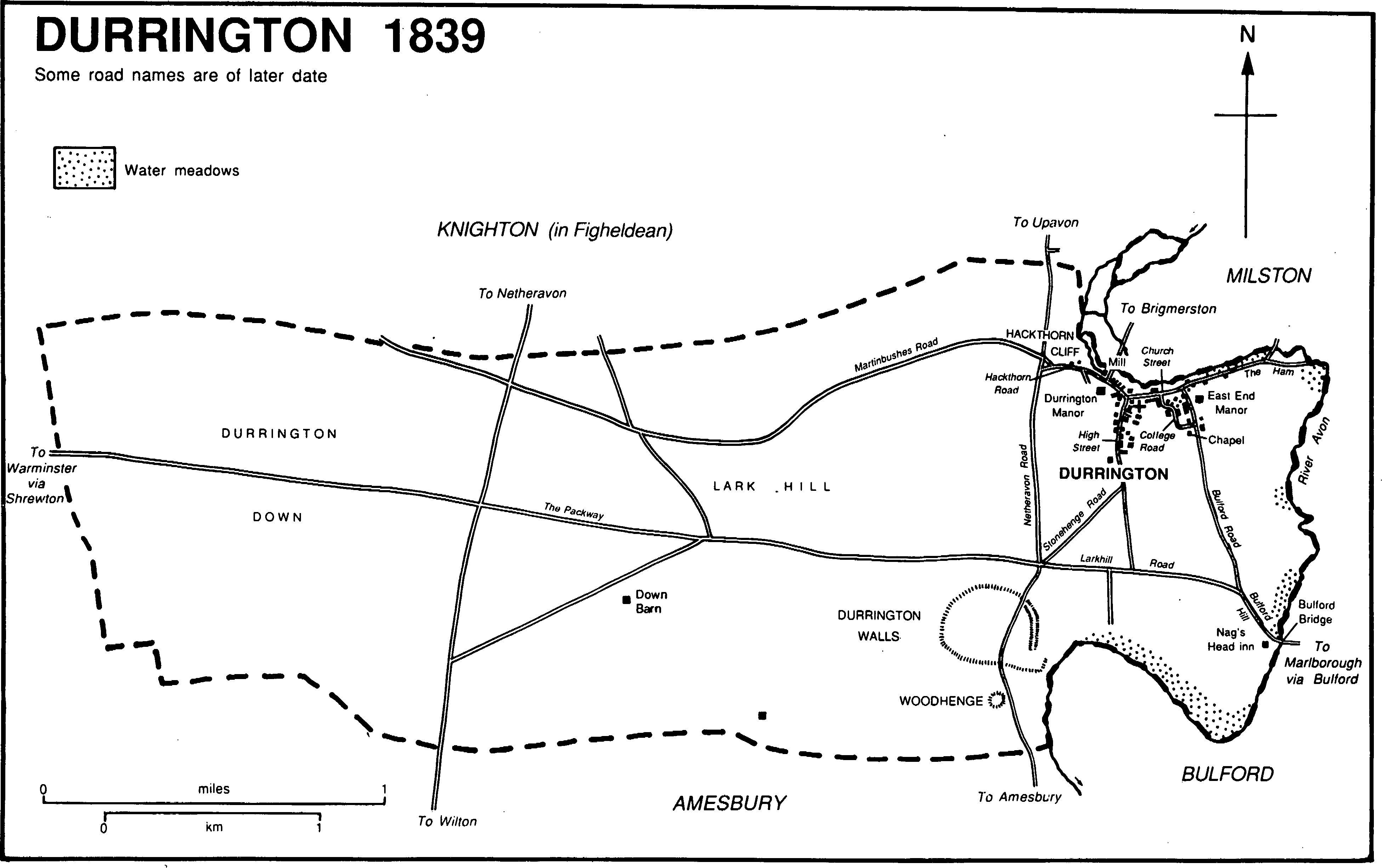
Durrington 1839
The whole parish is on Upper Chalk: to the east gravel deposited by the Avon forms a wide terrace, and there is a narrow strip of alluvium beside the river. (fn. 7) The highest point, at 134 m., is a little south-west of the village; land at c. 120 m. is in the centre of the parish, an area called Lark Hill in the mid 19th century. (fn. 8) From Lark Hill the downland falls gently westwards to c. 107 m. at the boundary; eastwards the fall to c. 75 m. beside the river is steeper. Near the river in the north-east corner of the parish high ground called Hackthorn Cliff reaches 87 m. As usual for a long and narrow downland parish there were meadows beside the river, open fields on the gravel and on the chalk nearer to the village, and rough pastures on the downs further from the village. (fn. 9) There was no woodland in 1773 (fn. 10) and very little c. 1900. (fn. 11) In the 20th century c. 10 plantations, each of a few acres, have been made on the downs by the army. (fn. 12)
Two main roads cross the parish, one east-west and one north-south. The Bulford—Shrewton road, called Packway by c. 1555, was from the 17th century or earlier to the 19th part of a London—Warminster road via Marlborough; (fn. 13) between Bulford bridge and Lark Hill it was turnpiked in 1761, disturnpiked in 1871. The Upavon—Amesbury road, called Netheravon Road across Durrington parish, was turnpiked in 1840 and disturnpiked in 1877. It carries some traffic from Devizes and Marlborough to Salisbury. To avoid Woodhenge in the south part of the parish it was diverted to the east c. 1969, and a roundabout was made at its junction with the Bulford—Shrewton road. (fn. 14) Two other roads across the parish may have been well used in the 18th century: a north-south road led from Netheravon via Stonehenge towards Wilton, and an east-west road, called Martinbushes Road in the 20th century, linked Durrington village with the main Devizes—Salisbury road west of the parish. (fn. 15) By the early 19th century the Wilton road was apparently of little importance; (fn. 16) in the 20th both that and Martinbushes Road ceased to be through routes when part of each was closed to the public within a military training area. The Wiltway, east of and presumably parallel to the Wilton road, was evidently closed in Amesbury parish in the later 18th century (fn. 17) and had gone out of use in Durrington by the early 19th. (fn. 18)
What became Durrington parish was inhabited from Neolithic times, and the parish is rich in archaeological remains. It contains the sites of two large henge monuments, Durrington Walls and, south of it, Woodhenge. The monuments were built over what was apparently the site of a late Neolithic village, which included a long house. (fn. 19) South of Woodhenge a prehistoric ditch and an egg-shaped enclosure perhaps embracing the site of a circular house were possibly for agricultural use. (fn. 20) Cereals, mostly barley, were cultivated and pigs and other animals were reared; (fn. 21) north-east of Durrington Walls there were trial flint workings. (fn. 22) South-west of Durrington Walls a Romano-British village of the late 3rd century or early 4th, from which cereals were cultivated, stood on the site of a Neolithic settlement. (fn. 23) Elsewhere in the parish prehistoric artefacts have been discovered and there are barrows of various types, including four long barrows. (fn. 24) A prehistoric field system of c. 280 a. extends into the parish from Knighton in Figheldean parish. (fn. 25)
Durrington, with 139 poll-tax payers, was one of the most populous villages of the hundred in 1377. (fn. 26) The population rose from 339 in 1801 to 477 in 1851 and was 427 in 1901. Thereafter it increased rapidly as military camps on the downs and houses in the village were built. It was 897 in 1911, 3,005 in 1921, 5,784 in 1951. (fn. 27) The presence of fewer soldiers caused a decrease to 4,737 in 1961. The population was 6,734 in 1971, 6,926 in 1991. (fn. 28)
Durrington village stands on the gravel, off the main roads and within an eastwards meander of the Avon. It apparently contained two separate groups of buildings, each in a north-south street with, at the north end, the church between them on an elevated site. (fn. 29) Settlement also developed east and west along and beyond the street, now called Church Street, in which the church stands, and in the 20th century has grown extensively to the south.
In the eastern street, now called Bulford Road, few of the farmhouses, farmhouses, farm buildings, and cottages standing in 1839 (fn. 30) survive. The principal one that does, on the east side, is East End Manor, the north-south hall range of which preserves the plan of a medieval house. The house was made L-shaped c. 1610, when, evidently for Anthony Trotman, (fn. 31) a timber-framed east-west range with a central chimney stack was built east from the south end. A large central stack was built in the hall, possibly at that time. The south and west walls of the house were reconstructed in flint rubble, possibly in the later 17th century, and the east and north walls of the hall range in brick in the earlier 19th. In the lane now called College Road, across the angle of Bulford Road and Church Street, Brown's Farmhouse was built in 1784, perhaps for Henry Dowling; (fn. 32) Red Cottage has early 19th-century cast-iron window frames with angular heads, as does a school built nearby in 1843. (fn. 33) A nonconformist chapel was built near the junction of College Road and Bulford Road evidently in the early 19th century. (fn. 34) The Plough inn was open in Bulford Road in 1851 (fn. 35) and in 1992.
Most farmsteads in the village were in the western street, now called High Street, and perhaps seven of the farmhouses standing in 1839 survive, six on the west side. The northernmost on that side, Collins's Farm, was built in the early 19th century as a two-storeyed, three-bayed house with a slate roof. West End Manor Farm is a later 18th-century house, and the Red House is a mid 18th-century brick house heightened and refronted in the later 18th century. Further south, Parsonage Farm was almost entirely rebuilt as a red-brick house with stone quoins in the 19th century, when it was possibly extended southwards, but incorporates a north gable of c. 1700 built of flint rubble, banded stone, and red brick. Hollyhurst is a thatched early 18th-century farmhouse of four bays which may have been built of banded flint and stone. Pinckney's, the southernmost farmhouse on the west side, was built in brick for Philip and Jane Pinckney c. 1769. (fn. 36) On the east side, Church Farm is late 18th-century. South of it, and set back from the street, Durrington House was built as a gentleman's residence in the mid 19th century, evidently for G. P. Moore: (fn. 37) it was demolished after 1961. (fn. 38) A lodge for it survived in High Street in 1992.
By the early 19th century settlement had extended from the church along Church Street east to the Ham and west into Hackthorn Road. (fn. 39) In the late 18th century or early 19th a bridge over the Avon was made at the east end of the Ham (fn. 40) which then became the main route from Durrington to Milston: a footbridge survived in 1992. South of Hackthorn Road, Durrington Manor was built c. 1800, possibly on an old site: (fn. 41) it is a large red-brick house and has a five-bayed north entrance front in which is a central timber porch with columns; it was a hotel c. 1949 (fn. 42) and was in flats in 1992. Durrington mill was on the north side of Hackthorn Road: a lane leading from it over Hatches bridge to Brigmerston in Milston in the early 17th century and the 19th (fn. 43) was a footpath in 1992. On the north side of Church Street a large early 17thcentury farmhouse, with a two-storeyed porch and canted bay windows on the principal south front, (fn. 44) was lived in by the rector in the 19th century and early 20th: it was rebuilt c. 1920 after a fire. (fn. 45) In the 19th century cottages on the north side of Hackthorn Road were altered or rebuilt and cottages were built on the north side of Church Street. The junction of High Street, Church Street, and Hackthorn Road became a focal point of the village, and the base of a medieval cross was moved to the centre of the junction, perhaps from the churchyard and apparently in the 19th century. (fn. 46)
Houses and cottages of the 17th century, possibly of timber and cob and with thatched roofs, survive in College Road, High Street, and Church Street: most were altered in the 19th century and rendered. Between 1839 and c. 1900 the village grew little in extent. Outside it a farmhouse beside Bulford bridge was open as the Nag's Head in 1731. The house was rebuilt or extensively altered in the late 18th century or early 19th; (fn. 47) a friendly society met in it in 1836. (fn. 48) At the junction of the Upavon—Amesbury and Bulford—Shrewton roads west of the village the Stonehenge inn has been open since c. 1875. It may have taken trade from the Nag's Head which was closed between 1885 and 1898. (fn. 49) On the downs several groups of farm buildings had been erected by the 1880s, at one of which, Down Barn, there was a cottage in 1839. (fn. 50)
The growth of the village in the 20th century was stimulated by the presence of the army in the parish. (fn. 51) By 1923 houses and business premises had been built on both sides of Bulford Road from its junction with College Road south to the Bulford—Shrewton road; two new schools and buildings in east and west offshoots of Bulford Road had also been erected. Opposite College Road one of the eastern offshoots was later called School Road. The Bulford—Shrewton road was later called Bulford Hill east of Bulford Road, Larkhill Road west of it: by 1923 a few houses had been erected on the north side of Bulford Hill, a cinema on the south side of Larkhill Road. Also by 1923 a village hall had been built in High Street and eight cottages for the War Department on the west side of Netheravon Road. (fn. 52)
By the late 1930s there was a continuous line of settlement from Bulford bridge to the Stonehenge inn: 60 council houses were built on the north side of Larkhill Road 1927–32, and several private houses on the north side of Bulford Hill about the same time. Council houses were also built in the 1930s in Meads Road, as the south part of High Street came to be called, and by the late 1930s c. 12 more cottages had been built on the west side of Netheravon Road and private houses in and off Stonehenge Road, which links the junction of Larkhill Road and Netheravon Road with High Street. (fn. 53) In the 1950s a large council estate was built south of Coronation Road, a new east-west road linking Bulford Road and Meads Road, and the estate was extended northwards in the 1960s. (fn. 54) Private bungalows built over the grounds of Durrington House filled the space between the council estate and the old part of the village in the 1960s. Since then more private houses have been built in new roads east of Bulford Road and west of Stonehenge Road. In the old part of the village new building in the later 20th century, besides infilling, included a few new houses in the Ham and some old people's bungalows in College Road. At the north-west corner of the village c. 12 houses were built north of Hackthorn Road in the 1950s. As the village grew, various shops and small businesses were opened, (fn. 55) a police station was built, a branch of the county library was opened in 1971, (fn. 56) and in 1974 a sports centre with a swimming bath was opened at the east end of School Road. (fn. 57)
The part of Salisbury Plain north-west of Durrington has been used by the army for artillery practice from 1899. A camp for those using the ranges was set up on Durrington down in 1899, (fn. 58) and in the 20th century the camps, barracks, houses, and other buildings on the down became known generally as Larkhill camp. From 1920 Larkhill camp has been the headquarters of the School of Artillery, from 1970 the Royal School of Artillery, (fn. 59) and in the late 20th century was still used mainly for gunnery. It covered c. 800 a. in 1992. (fn. 60)
Before the First World War there were three tented camps, Durrington, Larkhill west of it, and Fargo near the western parish boundary. (fn. 61) The Larkhill light military railway was constructed from Ratfyn in Amesbury to the Fargo camp in 1914, and served all three camps. (fn. 62) Between 1914 and 1918 the Fargo camp included a military hospital (fn. 63) and the tents were replaced by huts at Larkhill camp. (fn. 64) In the 1920s permanent brick buildings were erected throughout the camp and the Packway, which the camp stood astride, became the principal access route: (fn. 65) the railway had been closed by 1928 and its tracks removed by 1937, (fn. 66) and the Packway was tarmacadamed and in 1929 lined with trees. In 1928 Strangways, an estate of 23 houses for married officers, was built south-east of the camp, and in 1928–9 a row of 36 semidetached houses for married soldiers was built in Fargo Road between Strangways and the camp. At the camp itself new barracks north of the Packway and 84 houses south of the Packway were built in the 1930s. (fn. 67) Two new messes for officers were built, one south of the Packway in 1938, one north of the Packway 1936–40: both are of red brick in neo-Georgian style. (fn. 68) By the late 1930s most of the buildings of the military hospital had been removed. (fn. 69)
Much of Larkhill camp was rebuilt in the 1960s, retaining the earlier grid system of roads; (fn. 70) most of the barracks and workshops are north of the Packway, most of the houses south. Alanbrooke barracks, begun c. 1960, (fn. 71) Stirling, begun in 1966 and containing the headquarters of the Royal School of Artillery, Roberts, begun in 1964, (fn. 72) and Home, the headquarters of two military bands, are all north of the Packway. (fn. 73) In the 1950s and 1960s more houses were built in the south and east parts of the camp and to the south-east between Strangways and Durrington Walls. In 1992 an ammunition store stood near the western parish boundary.
Larkhill camp has become like a small town. It has been provided with sports grounds, churches, (fn. 74) banks, shops, a school, (fn. 75) and a police station. A cinema built by 1915 was burned down in 1919; its replacement was closed c. 1971. (fn. 76) The Packhorse inn was opened on the south side of the Packway in 1962, (fn. 77) and a medical centre, a swimming pool, and a NAAFI were opened later. Between 1947 and 1952 a pack of beagles was kept. (fn. 78)
Manors and other estates.
Until the 12th century Durrington was apparently part of the king's estate called Amesbury, (fn. 79) but by 1120 had become a separate manor. (fn. 80) About 1155 Henry II granted what became WEST END manor to Hugh Hussey. (fn. 81) The estate reverted to the king c. 1179 (fn. 82) and was evidently granted to Stephen Chamber c. 1180. (fn. 83) On Stephen's death c. 1189 it passed to his relict Gillian, also relict of Alan de Neville. Gillian held it until c. 1195, as did Robert de Vipont from c. 1195 to 1199. Hugh de Neville acquired the manor in 1199: (fn. 84) his title was challenged unsuccessfully by Hugh Hussey's nephew Henry Hussey in 1201. (fn. 85) From Hugh de Neville (d. c. 1229) the manor descended to his son Ernis, (fn. 86) who successfully defended his title to it against Henry Hussey (d. 1290) in 1253. (fn. 87) From Ernis (d. 1257) it descended in the direct line to Gilbert (fn. 88) (d. 1294), John (fn. 89) (d. 1334), and Gilbert de Neville (fn. 90) (d. 1359). The younger Gilbert's heir was his daughter Elizabeth (fn. 91) (d. s.p. 1393), wife of Simon Simeon (d. 1387) and of John la Warre, Lord la Warre. John held the manor until his death in 1398, (fn. 92) and in 1399 his and Elizabeth's feoffees sold it to Winchester College. (fn. 93) The college owned it, c. 1,600 a. in 1838, (fn. 94) until the 20th century. (fn. 95)
From 1604 to 1718 the entire West End manor was leased to members of the Poore family. Leases of East End manor descended in the same family. (fn. 96) Philip Poore (d. 1640) was followed as lessee of West End by his son Edward (d. 1656), (fn. 97) possibly by Edward's son Edward (d. 1672), by that Edward's nephew Philip Poore (d. 1693), and by that Philip's relict Elizabeth and son Philip (d. 1719). (fn. 98) From 1781 the lessees were Thomas Fowle (d. 1783), (fn. 99) his brother Henry (d. 1803), (fn. 100) Henry's son William (d. c. 1840), William's son T. E. Fowle (d. 1877), (fn. 101) and T. E. Fowle's son T. E. Fowle (d. 1932). (fn. 102)
The last lease of the entire manor apparently expired in the late 19th century. In 1899 Winchester College sold 292 a. and the reversion of 278 a. held by copy to the War Department, and in 1902 a further 400 a. and the reversion of a further 389 a. of copyhold. The Ministry of Defence owned nearly all that land in 1992. (fn. 103) The college kept c. 100 a., (fn. 104) which it sold between 1921 and 1949. (fn. 105)
What became EAST END manor may have developed from one or both of two 11th-century estates. A thegn held I hide in 1066; that and 1½ hide were afterwards held and forfeited by Aubrey de Couci, and were held by the king in 1086. (fn. 106) What became the manor may have been held by Robert de Beaumont, count of Meulan (d. 1118), and in 1120 his sons Waleran, count of Meulan, and Robert, earl of Leicester, licensed their undertenant Ralph de Anquetil to grant it to the abbey of Bec-Hellouin (Eure). (fn. 107) In an exchange c. 1208 the abbey gave the manor to the bishop of Salisbury, who had assigned it by 1215 for the common fund. (fn. 108) The dean and chapter also held land at Knighton and treated it as part of East End manor. At inclosure in 1823 they were allotted c. 300 a. in Durrington but increased their holding there to 488 a. by giving land at Knighton in exchange. (fn. 109)
From the early 17th century to the 19th members of the Poore family, some of whom were lessees of West End manor, (fn. 110) held the entire manor by lease from the dean and chapter. Edward Poore (d. 1656) was lessee from 1606. (fn. 111) Leases were held by his son Edward (d. 1672), by that Edward's nephew Philip Poore (d. 1693), by Philip's relict Elizabeth (d. 1728), by Philip's and Elizabeth's daughter Venetia (d. 1741), and by Venetia's cousin Edward Poore (fn. 112) (d. 1780). From 1780 Edward's nominees held the lease in trust for his daughters Eleanora Michel (d. s.p. 1812) and Charlotte Poore (will proved 1829); Charlotte devised her interest to Sir Edward Poore, Bt. (d. 1838), who was lessee from 1834. The lease presumably passed to Sir Edward's son Sir Edward Poore, Bt. (d. 1893), but was apparently not renewed after 1855. As lessees, members of the Poore family granted nearly all of the land of the manor to themselves by copy on lives. (fn. 113) In 1900 the Ecclesiastical Commissioners sold the freehold of 485 a. to the younger Sir Edward's son Sir Richard Poore, Bt. Of that land Sir Richard sold 213 a. to the War Department in 1902, his relict Ida sold some in 1955 and 1956, (fn. 114) and Ida's executors sold the remainder to the War Office in 1958. In 1992 the Ministry of Defence owned the land bought in 1902 and 1958. (fn. 115)
Hugh de Neville (d. c. 1229), lord of West End manor, granted 2 yardlands, which may have been the origin of MARSH'S farm, to Thomas Hiredman. The land was held in 1340 by Thomas's kinsman and heir Thomas Ward (fn. 116) (d. by 1361), whose relict Lettice in 1390 granted it to her son John Ward for life. (fn. 117) Like an estate in West Ashton in Steeple Ashton it passed to John Lyveden, who settled it in 1464 on his wife Amice (fl. 1497). (fn. 118) John Westley (d. 1521) held the estate in 1511; Anne (fl. 1562), wife of Henry Tichborne, held it for life c. 1527. The reversion passed to John Westley's son Thomas (d. 1561), to Thomas's son Leonard (d. 1562), and to Leonard's son Thomas, (fn. 119) who may have sold the estate after 1579. (fn. 120) It was perhaps the 2-yardland farm owned in 1608 by William Staples and sold by him c. 1613 to Thomas Staples. (fn. 121) The land was owned c. 1622 by Anthony Trotman (fn. 122) and in 1735 by John Batch (d. 1767). From Batch's sister Anne Marsh (d. 1770), Marsh's farm passed to her son Thomas Marsh, who in 1816 sold it to Charlotte Poore (will proved 1829). (fn. 123) At inclosure in 1823, when 74 a. were allotted in respect of it, the estate was given to the dean and chapter of Salisbury in exchange for land in Knighton and became part of East End manor. (fn. 124)
Hugh de Neville (d. c. 1229) granted lands to John de Bessin. (fn. 125) BESSIN'S was conveyed by the feoffees of Agnes, relict of Thomas Bessin, to Winchester College, lord of West End manor, in 1414, (fn. 126) but was afterwards held freely by John Greenleaf and his wife Maud, who together sold 2 yardlands in 1433 to Ralph Thorp (fn. 127) (d. 1446). The estate descended with East Boscombe manor (fn. 128) until Henry Clifford sold it to Philip Poore in 1595. (fn. 129) It descended in the Poore family, apparently like the lease of West End manor, to Philip Poore (d. 1719). (fn. 130) Its later descent is obscure.
Land held by Thomas Woodford 1435 X 1450 (fn. 131) may have been the 2 yardlands, possibly the origin of LAWES farm, sold by Nicholas atte Mere to Sir Roger Tocotes in 1480. (fn. 132) Sir Roger (d. 1492) was deprived of the land in 1484–5. (fn. 133) Another Roger Tocotes owned it in 1494. (fn. 134) An estate which passed in the Wilkinson family from 1523 until Christopher Wilkinson sold it to Robert Wyryat c. 1537 was possibly the same land. (fn. 135) Wyryat sold the estate c. 1547 to John Flower, who sold it to William Stumpe (d. 1552). Stumpe's son Sir James apparently sold it in two portions: in 1553 he sold land to John Cowper, and c. 1555 other land to Richard Cowper (fn. 136) (d. 1558), who devised it to his daughter Maud and her husband Thomas Lovell. (fn. 137) John Cowper's 110–a. estate, which in 1561 passed to his relict Margaret (d. 1599), may have included both portions; it descended to his son Thomas (fl. 1618), a lunatic. (fn. 138) What is likely to have been the same estate belonged to Leonard Lawes (d. c. 1775), (fn. 139) and other land was added to it. (fn. 140) From Thomas Lawes (d. by 1809) Lawes farm passed to his sisters Jane Lawes (d. by 1812), Christian Lawes, Alice Lavington, and Susanna Amor. Alice sold her share in 1816 to Sir John Poore, Bt. (fn. 141) (d. 1820). At inclosure in 1823 Poore's grandnephew and heir Sir Edward Poore, Bt., gave that share, in respect of which 91 a. had been allotted, to the dean and chapter of Salisbury in exchange for land in Knighton, and it became part of East End manor. (fn. 142) The remainder of Lawes farm passed to Susanna Amor's son Thomas Amor, who sold it c. 1817 to George Moore (d. 1820). Moore devised it to his son Thomas (d. 1841), who held 275 a. in 1839. Thomas's successor was his brother G. P. Moore (d. 1884), (fn. 143) who sold the land in 1883 to A. T. Squarey, James Rawlence (d. 1894), and E. P. Squarey as tenants in common. In 1898 the Squareys sold all but c. 38 a. to the War Department. All was owned by the Ministry of Defence in 1992. (fn. 144)
An estate of 2–3 yardlands, later called INGRAM'S, was sold in 1409 by William Wake and his wife Amice to John Ingram. (fn. 145) It descended in the Ingram family, possibly until the earlier 18th century, (fn. 146) and in 1776 was part of Lawes farm. (fn. 147)
The tithes of Durrington may have belonged to Amesbury abbey, and in 1179 they were confirmed to Amesbury priory. (fn. 148) In the early 13th century the priory added to its estate in Durrington 3 yardlands granted by John Bonet and 1 yardland granted by Robert Goion; (fn. 149) free warren in its demesne was granted to it in 1286. (fn. 150) The RECTORY estate, the tithes and 6 yardlands in 1421, (fn. 151) passed to the Crown at the Dissolution and was granted in 1541 to the dean and chapter of Winchester. (fn. 152) They held 238 a. in 1838, when their tithes were valued at £590 and commuted. (fn. 153) From the later 17th century the whole estate was leased: the lessees were William Moore, c. 1679 to 1693, John Moore, 1693 to c. 1722, Thomas Moore (d. 1753), rector of Steepleton Iwerne (Dors.), Thomas Moore (d. 1783), Jonathan Moore (d. 1818), George Moore (d. 1820), and G. P. Moore (d. 1884). (fn. 154) In 1862 G. P. Moore surrendered the lease of £493 of rent charge to the Ecclesiastical Commissioners, and in 1865 he bought from them the freehold of Parsonage farm, 237 a., and of the £93 rent charge on it. (fn. 155) Moore sold the farm and the rent charge with Lawes farm to A. T. Squarey, James Rawlence, and E. P. Squarey in 1883, and the Squareys sold them to the War Department in 1898. The Ministry of Defence owned the land in 1992. (fn. 156)
Economic history.
Agriculture. The two Durrington estates described in 1086, totalling 2½ hides, had land for 2 ploughteams and included 10 a. of meadow; 1 hide was in demesne and there were 4 coscets and 1 bordar. (fn. 157)
The parish apparently contained two sets of open fields, one for West End manor in the south part of the parish and one, much smaller, for East End manor in the north. The extensive downland pasture, however, seems to have been used jointly by the men of each manor. (fn. 158) The location of the two sets of farmsteads, those of West End manor to the west in High Street, those of East End manor to the east in Bulford Road, apparently gave the manors their names. (fn. 159)
The fields of West End evidently included the arable of the demesne and customary holdings of West End manor and that of the Rectory estate and the holdings later called Marsh's, Bessin's, Lawes, and Ingram's. In 1229 the demesne of West End manor, on which there were 16 oxen and a flock of c. 200 sheep, was leased for three years to Amesbury priory, which could distrain upon the tenants for non-performance of customary services. (fn. 160) In the early 14th century six tenants at will held 15 a. of demesne by lease; two ploughmen, an oxherd, a doorkeeper, and a maid were employed on the remainder. (fn. 161) Sheep-and-corn husbandry was practised on West End manor, and there were apparently three West End open fields in 1334. (fn. 162) Demesne of the manor lay in North meadow, and there were other meadows called the Moor, East meadow, and South meadow. (fn. 163) Most demesne grain was sold in the earlier and mid 14th century, usually at Salisbury, and in 1331–2 some was bought for the king's household at Clarendon palace. In the 1320s demesne pasture was leased to the customary tenants for their flock, then c. 750 sheep. About 1340 the tenants, whose flock numbered 776 in 1353–4, were intercommoning in the south part of Durrington with men of Amesbury: such intercommoning had ceased by 1538. From c. 1334 to c. 1359 a small demesne flock was kept: at its largest, in 1350, it numbered 212. There were 17 yardlanders and 20 cottagers on West End manor in 1329, 16 and 20 in 1340. In 1340 the yardlanders, as part of their carting duties, had to carry grain off the manor for sale. The cottagers made hay and, when a demesne flock was kept, washed and sheared the sheep. There were only 12 yardlanders in the later 14th century, and from c. 1356 there were 4½-yardlanders who each had to do ploughing services. (fn. 164) The demesne of West End manor, on which a substantial farmstead was built in the earlier 15th century, was leased from 1389: there is evidence that John Langford, lessee 1458–78, managed it inefficiently. (fn. 165)
In the 16th century the West End arable was in four open fields, but in 1590 the number of fields was reduced to three and exchanges of land were made between tenants. (fn. 166) The fields were called Coombe, North, and South in 1622, (fn. 167) Coombe Bottom, Lark Hill, and Cuckoo Stone in 1797. (fn. 168) They remained open until 1823. (fn. 169) Some land, however, was apparently used in severalty. In 1655 and later the demesne of West End manor included land in the open fields but also several arable in three farm fields and a several down of 150 a.; also in 1655 the 5-yardland demesne of the Rectory estate, then evidently worked from its own farmstead, had an apparently several down of 150 a., (fn. 170) 11 a. of which had been burnbaked by 1684; (fn. 171) in 1776 the demesne of the manor included downs of 170 a. and 134 a. in severalty, part of the larger of which was occasionally burnbaked. (fn. 172) Those sharing the commonable downland, the freeholders and the tenants of West End manor, agreed in 1740 to burnbake 12 a. of down near the boundary with Shrewton, to elect a small committee to lease the land, and to use the rent to pay for a pond to be constructed on the land. (fn. 173) In 1776 there was a common sheep down of 824 a., a common cow down of 188 a.: in 1807 the downs were said to be of 837 a. and c. 200 a. Rights to use them also belonged to East End manor, and 1,796 sheep could be kept. In 1804 the demesne of West End manor included 505 a. of arable, the nine copyholds included 504 a., and Lawes farm was of 8 yardlands. The demesne was worked with some of the copyhold land; of its 239 a. of downland 104 a. were under the plough, and in the late 18th century a barn and penning was built on it. In 1807 the West End farms had c. 33 a. of apparently several water meadows. (fn. 174)
In addition to its open fields, East End manor had 4 a. of common pasture scattered about them, and c. 8 a. of water meadows. The fields contained c. 220 a. and those with land in them evidently had some rights to feed animals on the downs of the parish. (fn. 175) As lessees the Poores granted nearly all the land of the manor by copy to members of their family, and in the early 19th century it was worked as a single farm from East End Manor. (fn. 176)
The open fields and common pastures in the parish were inclosed in 1823 by Act. Apart from the home closes and closes between the village and the river, all the land of the parish was allotted, whether in common or several use before. As a result most of the farms were made compact. After inclosure the demesne of West End manor was 473 a., the East End manor farm 488 a., Parsonage farm 238 a., and Lawes farm 275 a.; copyholds of West End manor were of c. 280 a., 209 a., 195 a., 146 a., 104 a., 71 a., and 56 a. All 11 farms were worked from buildings in the village and some may have been worked together. About 1840 there were virtually equal amounts of arable and grassland in the parish, and the largest farms were composite ones of 683 a., 637 a., and 627 a., the second of which may have been worked with 421 a. in Knighton. There were two groups of farm buildings on the downs c. 1840, (fn. 177) five c. 1880. (fn. 178)
In the later 19th century the parish contained slightly more arable than pasture. The chief cereal crop was barley; on the grassland c. 3,000 sheep, c. 30 cattle, and c. 90 pigs were usually kept. (fn. 179) The amount of agriculture was reduced from 1899 by the building of Larkhill camp and the use of land for military training. (fn. 180) A. C. Young of Watergate Farm in Bulford occupied 1,830 a. of the parish in 1910, but much of it could not be used for agriculture; a farm of c. 290 a. was based at Durrington House, and three farms of less than 100 a. were apparently worked from farmsteads in the village. (fn. 181) Arable farming declined in the earlier 20th century, and in the early 1930s was restricted to c. 400 a. on both sides of the Upavon—Amesbury road. On the rest of the land not used by the army dairy and beef cattle and large flocks of sheep were kept. (fn. 182) Since then the agricultural land has been further reduced. In 1992 there was arable between the Upavon—Amesbury road and Larkhill camp and pasture in the south-west corner of the parish: those at Down Barn were apparently the only farm buildings in use in the parish.
Mill. A water mill north-west of the church was part of the demesne of West End manor from 1331–2 or earlier. (fn. 183) Its working was severely impeded by new mills built downstream in Milston in 1611. (fn. 184) Durrington mill evidently ceased to work between 1877 and 1899, and it was demolished between 1899 and 1923. (fn. 185)
Trade and Industry. Two weavers lived in Durrington in 1580, (fn. 186) one in 1754. (fn. 187) Malting was carried on in the 18th century (fn. 188) and early 19th, c. 1838 in a malthouse west of the church. (fn. 189) West of the village the Stonehenge inn incorporated the Crossroads brewery from c. 1875: (fn. 190) c. 1917 it was bought by Portsmouth (later Portsmouth & Brighton) United Breweries, (fn. 191) which had a depot there until c. 1981. (fn. 192) A bacon factor was based in the parish in the later 19th century. Then and in the earlier 20th racehorses were trained at stables at Durrington House. (fn. 193)
From c. 1911 various small businesses became established in the village, especially in Bulford Road, to supply Larkhill camp. (fn. 194) A branch of Lloyds Bank was opened in Bulford Road in 1919 and closed in 1990. (fn. 195) A branch of the London Joint City & Midland Bank Ltd., later the Midland Bank, was open c. 1923 and in 1992. (fn. 196) From the 1920s the War Department's estate office has been at the Red House in High Street. (fn. 197) The number of shops and small businesses, still mostly in Bulford Road, increased as the village grew in the mid and later 20th century. Those in Bulford Road in 1992 included a motor repair works, a veterinary clinic, and a betting shop. In High Street there was a pets' undertaker and an animal crematorium. From 1971 protective packaging materials were made by Carton Industries Ltd. at a factory in Bulford Road where 11 people were employed in 1992. (fn. 198) In 1980 the firm of Hassett International was set up in Bulford Road by Mr. L. Hassett for the design and supply of infra-red heating equipment for industrial use; in 1989 the firm moved to a factory in Larkhill Road where 10 people were employed in 1992. (fn. 199) Also at premises in Larkhill Road the firm R.M.C. Ltd. has prepared ready mixed concrete from 1986 or earlier. (fn. 200)
Local government.
Records of the court for West End manor survive with gaps from the early 14th century to the later 19th. (fn. 201) The court met four times a year 1319–24. From c. 1335 it met twice a year in spring and autumn, and its title reflected the lord's claim to leet jurisdiction and view of frankpledge. In the period 1426–36 the bailiff and the constable of Amesbury hundred were presented for having infringed the lord's franchises. (fn. 202) In the earlier 14th century the court heard and determined pleas of debt and of trespass, but otherwise there was little manorial business. The officers of the court included a tithingman, chosen at the autumn meeting, and an aletaster. From 1361 both leet and manorial business was energetically prosecuted. In 1400 the chaplain of Durrington was presented for assault. Five neifs, members of one family, were presented from 1511 for having left the manor; in 1514 a customary tenant was presented for taking his grain to a mill at Amesbury; and in 1511 and 1514 butchers and the miller of Durrington were presented for overcharging. Besides the usual manorial concerns, such as the regulating of common husbandry, copyhold transactions, and the repair of tenements, fishing in the Avon was closely regulated. In 1511 tenants of West End manor were forbidden to fish the common water more than twice a week, in 1515 a tenant of East End manor was presented for having removed a hatch and for catching trout and eels from his boat in the West End stretch of the river, and in 1518 two West End tenants were presented for netting trout in the lord's demesne waters. East End tenants were presented for trespassing with their animals on West End meadows in 1515. From 1604 the court was held by the lessees of the manor, and dealt mainly with manorial offences. In the 18th century, when the officers included a hayward and two hay weighers, it was usually held once a year in spring. From the mid 19th century, when it was held at Durrington Manor, (fn. 203) to 1884 it was held only when copyhold business required it.
Records of the court of East End manor survive with gaps for the period 1609–1854. In the 17th century and early 18th the court was called view of frankpledge and court, from the mid 18th court leet, view, and court baron. It was held both for that manor and for the manor of Knighton in the same ownership, but the business of the two was not distinguished in the records. It was held by the lessees of East End manor, usually twice a year in the 17th century, thereafter once a year or when copyhold business required it. The court appointed a hayward and a tithingman but dealt mainly with copyhold business. Exceptionally, pleas of debt and of trespass were heard in 1609. (fn. 204)
In 1802–3 a quarter of the population of the parish and 31 from outside it received poor relief at Durrington; £306 was spent on regular relief for 37 adults and 58 children, occasional relief for 20 adults, and instruction in spinning. (fn. 205) Poor relief was generous 1812–15 when an average of £364 a year was spent on regular relief for c. 27 adults and on occasional relief for c. 22. (fn. 206) Relief may have been less generous thereafter, especially as the population of the parish increased rapidly; in 1822–4 an average of £265 was spent, 1825–9 £361, and 1830–4 £419. Expenditure was highest at £471 in 1831. (fn. 207) The parish became part of Amesbury poor-law union in 1835 (fn. 208) and of Salisbury district in 1974. (fn. 209)
A vestry, apparently select, governed the parish from c. 1810. In 1835 it paid for 11 labourers to be employed by local farmers, in 1838 collected a rate for paupers to emigrate, and c. 1839 owned two houses in Hackthorn Road and a cottage in the Ham. (fn. 210)
Churches.
Durrington church was standing in the early 12th century. (fn. 211) It is likely to have belonged to Amesbury abbey and was confirmed to Amesbury priory in 1179. (fn. 212) It was served by a chaplain or curate nominated by the owners of the Rectory estate: c. 1650 the lessees of the estate had the right to nominate; from c. 1763 nominations were by the dean and chapter of Winchester as owners. (fn. 213) Under the Incumbents Act of 1868 the benefice became a vicarage. From 1869, when as owners of the Rectory estate the Ecclesiastical Commissioners gave him some of the commuted great tithes and charged him with repairing the chancel, the vicar was usually styled rector. (fn. 214)
The curate's salary was £20 in 1641, (fn. 215) £40 in 1677, and £53 c. 1830; in addition he received a sack of wheat and a sack of malt from the Rectory estate each year. (fn. 216) Queen Anne's Bounty augmented the living by £200 in both 1813 and 1826. (fn. 217) By an endowment given in 1844 the Ecclesiastical Commissioners increased the stipend to £100, (fn. 218) and in 1869, as owners of the Rectory estate, they replaced the stipend, then £125, by £296 of tithe rent charge from the parish. (fn. 219) The lessee of the estate endowed the living with a house in the earlier 17th century, (fn. 220) probably the cottage in College Road which was unfit for use c. 1830. (fn. 221) In 1936 a new Rectory was built east of the church. (fn. 222)
Robert Maton gave a flock of 20 sheep for the church, and the profits from 8 more sheep and from I cow for three lights in the church, all by will proved 1510. (fn. 223) The income from the 8 sheep was used in 1548 for a candle which burned in the church in front of the corpses of parishioners. (fn. 224) John Marris, chaplain 1456–1509, was apparently summoned to testify during the canonization process of St. Osmund. (fn. 225) In 1553 no quarter sermon was preached and the church lacked the Paraphrases of Erasmus, and in 1564–5 the curate, a drunkard, was incapable of officiating. (fn. 226) Leonard Maton, appointed before 1623 when in minor orders, (fn. 227) served the cure until 1684. (fn. 228) He signed the Concurrent Testimony in 1648, (fn. 229) and preached every Sunday c. 1650. (fn. 230) The church still lacked the prescribed books in 1662. (fn. 231) Henry Head, curate from c. 1715 to c. 1748, was master of a free school in Amesbury and may not have resided. (fn. 232) Richard Head, appointed in 1763, (fn. 233) lived in Amesbury and was rector of Rollestone and vicar of Compton Chamberlayne. In 1783 he held a service at Durrington every Sunday alternately morning and afternoon, and administered the sacrament at Christmas, Easter, Whitsun, and Michaelmas to fewer than 20 communicants. (fn. 234) Nicholas Westcombe, appointed in 1804, was murdered in 1813 near Winchester, where he lived. (fn. 235) Henry Fowle, appointed in 1828, had an assistant curate who in 1832 held Sunday services alternately morning and evening. (fn. 236) Fowle's successor Richard Webb, curate 1833–62, (fn. 237) was possibly the first to reside since the 17th century. From 1838 or earlier to c. 1910 successive curates and rectors lived in a house in Church Street. (fn. 238) On Census Sunday in 1851 the morning service was attended by 270, the afternoon one by 290. (fn. 239) In 1864 Webb's successor C. S. Ruddle (d. 1910) held services with sermons on Sunday mornings attended by c. 150, and on Sunday afternoons or evenings attended by c. 270. He held some weekday services on holy days, others, at which he lectured, weekly between autumn and spring; he administered the sacrament to c. 40 communicants at Christmas and Easter, and on the first Sunday of each month. (fn. 240) He published articles on the history of Durrington. (fn. 241) He was succeeded as rector by his son A. G. Ruddle (d. 1935), (fn. 242) who lived in East End Manor. (fn. 243)
The church had no dedication in 1763 (fn. 244) and was dedicated to ALL SAINTS in 1851. (fn. 245) It is built of knapped flint and freestone and has a chancel with south vestry, an aisled nave, and a west tower. Part of the north wall of an earlier 12th-century nave survived until the 19th century; (fn. 246) in the 13th the chancel was rebuilt, possibly on a larger scale, and the north wall of the nave and the south wall of the aisle were each given a pair of lancet windows. (fn. 247) About 1500 the double-lancet east window of the chancel was replaced by a triple lancet, and in the north wall of the nave a tall three-light window was inserted west of the doorway. (fn. 248) The tower was built in the earlier 16th century, partly into the nave, and has a west doorway and a north-east stair turret: its parapet and pinnacles, and the upper stage of the turret, were rebuilt from c. 1692, evidently after storm damage. (fn. 249) A west gallery erected in 1831 (fn. 250) possibly replaced or extended an earlier one. (fn. 251) In 1851 the church was extensively restored to designs by J. W. Hugall. The walls of the chancel were restored, the chancel arch was rebuilt, the south aisle was widened, the north aisle was built, the gallery was removed, and all the roofs were renewed: a blocked earlier 12th-century doorway, which on the inside had been concealed by a wall on which there was a large painting of St. Christopher, was moved from the north wall of the nave to form a porch in the south aisle. The vestry was built in 1973. (fn. 252) The church contains numerous 17th-century fittings, including an altar table, the pulpit, and the tower screen. Box pews, which incorporated carved panels, were cut down and rearranged, (fn. 253) apparently in 1851.
A chalice weighing 13 oz. was left in the church and 16 oz. of plate were taken by the king's commissioners in 1553. In 1992 the parish held a later 16th-century chalice and a paten hallmarked for 1691. (fn. 254) There were three bells in 1553. They were replaced by, or recast as, three bells by John Wallis, one in 1602 and two in 1617. Two bells cast by John Lott, one in 1654 and one in 1660, were added to the ring. The bells were rehung in 1916, (fn. 255) and in 1953 a sixth bell was added. (fn. 256) Registrations of baptisms, burials, and marriages survive from 1591, and are apparently complete. (fn. 257)
The church of ST. ALB AN THE MARTYR at Larkhill camp was built in 1938 to replace a wooden church erected there in 1914. It is of brick to designs by W. Ross and consists of an apsidal chancel and a nave; the nave has narrow aisles, north and south porches at the east end, a short south-west tower, and a north-west baptistry. (fn. 258)
Roman Catholicism.
St. Anthony's church at Larkhill camp was open in the 1930s, and may have been in the 1920s or earlier. Later, a hut on a different site was used as a church, and in 1968 a new church of St. Barbara and St. Anthony was opened. (fn. 259) Our Lady Queen of Heaven church was opened in Durrington village in 1960. (fn. 260)
Protestant nonconformity.
In 1662 John West and his wife refused to have their child baptized, and they and another married couple would not attend church; (fn. 261) the group was described as anabaptist in 1669. West certified his house for Presbyterian worship in 1672, (fn. 262) and there were nine dissenters in 1676. (fn. 263) There was said to be no nonconformist in the parish in 1783. (fn. 264) A meeting house was certified in 1821, and in 1824 a chapel, almost certainly that standing near the junction of College Road and Bulford Road in 1839, was certified by Independents. (fn. 265) On Sunday afternoons in 1850–1 c. 40 attended the chapel, (fn. 266) and in 1864 four families. (fn. 267) The chapel, rebuilt or altered in 1860, (fn. 268) may have been used by Wesleyan Methodists c. 1880 but was for Congregationalists in 1899. (fn. 269) In 1905 it was replaced by a new Congregational chapel in Bulford Road, which in 1965 joined the Evangelical Fellowship of Congregational Churches. (fn. 270) Services were still held in 1992.
Education.
The parish had one school in 1783, (fn. 271) three small schools in 1808, (fn. 272) and two schools with a total of c. 40 pupils in 1833. (fn. 273) A National school was built in College Road in 1843. (fn. 274) In it a woman taught c. 90 pupils in 1846–7, (fn. 275) 50–60 in 1858. (fn. 276) Average attendance was c. 52 in 1871, 74 in 1911–12. (fn. 277)
New schools were built in the village as the population of the parish increased in the 20th century. The school in College Road was reserved for infants when a new junior school was opened in School Road in 1912. In 1922 the school in College Road was closed, its pupils were transferred to that in School Road, and a new senior school was opened in Bulford Road. (fn. 278) Average attendance in 1926–7 was 147 at School Road and 152 at Bulford Road. At School Road numbers had fallen to 124 by 1938; they had risen to 235 at Bulford Road (fn. 279) partly because pupils from outside the parish attended. The Bulford Road school became a secondary modern school in 1944. (fn. 280) In 1961 the School Road building was reserved for infants, the juniors were transferred to Bulford Road, and a new secondary school was built at the north-east corner of the village. (fn. 281) The new school became a comprehensive school, Upper Avon, in 1974. In 1992 it had 746 pupils on roll, the junior school had 223, and the infants' school had 139. (fn. 282)
A primary school was opened in Larkhill camp in 1962 (fn. 283) and had 294 pupils on roll in 1992. (fn. 284)
Charities for the poor.
By will proved 1715 Thomas Allen gave £1 a year to the poor: the money was spent on bread c. 1833, was later given to a clothing club, and from the late 19th century was distributed in small sums to parishioners. Also in the 18th century 12s. a year was given to widows and 6s. a year to the poor: payments had ceased by 1833, and in 1901 the charities were deemed lost. About 1865 J. H. Alt, vicar of Enford, gave 12s. a year to be distributed on 1 January, 7s. to the oldest communicant, 5s. to the second oldest. Such payments were being made in the early 20th century but it is not clear how long they continued. (fn. 285)