A History of the County of Wiltshire: Volume 16, Kinwardstone Hundred. Originally published by Victoria County History, London, 1999.
This free content was digitised by double rekeying. All rights reserved.
A P Baggs, J Freeman, C Smith, J H Stevenson, E Williamson, 'Chute Forest', in A History of the County of Wiltshire: Volume 16, Kinwardstone Hundred, ed. D A Crowley (London, 1999), British History Online https://www.british-history.ac.uk/vch/wilts/vol16/pp120-126 [accessed 30 April 2025].
A P Baggs, J Freeman, C Smith, J H Stevenson, E Williamson, 'Chute Forest', in A History of the County of Wiltshire: Volume 16, Kinwardstone Hundred. Edited by D A Crowley (London, 1999), British History Online, accessed April 30, 2025, https://www.british-history.ac.uk/vch/wilts/vol16/pp120-126.
A P Baggs, J Freeman, C Smith, J H Stevenson, E Williamson. "Chute Forest". A History of the County of Wiltshire: Volume 16, Kinwardstone Hundred. Ed. D A Crowley (London, 1999), British History Online. Web. 30 April 2025. https://www.british-history.ac.uk/vch/wilts/vol16/pp120-126.
In this section
CHUTE FOREST
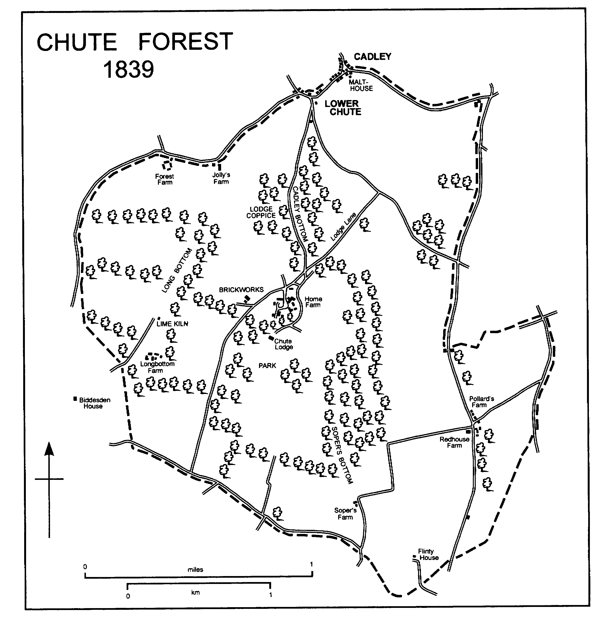
Chute Forest parish adjoins Hampshire c. 5 km. north-west of Andover. (fn. 1) Its land, which formed a rough quadrilateral, was the demesne wood of the Wiltshire part of Chute forest until it was disafforested in 1639, (fn. 2) and it was extra-parochial. Its inhabitants relieved their own poor from c. 1780 (fn. 3) and it was a civil parish in the 19th century. (fn. 4) A church was built in 1870-1, and from 1875, when the church was consecrated and the civil parish was assigned to it as a district, (fn. 5) Chute Forest was also an ecclesiastical parish. Between 1820 and 1839 an eastern projection of c. 150 a. at the south end of its east side, which was the Hampshire part of Chute forest in the earlier 17th century, was added to, or acknowledged to be part of, the parish, (fn. 6) presumably because the overseers of Chute Forest began to relieve paupers living on it. Thereafter the parish measured 1,973 a. (798 ha.) until 1987, when it was increased to 825 ha. by a transfer of land to it from Ludgershall. (fn. 7)
The boundary of the parish as it was in 1820, most of which, as the boundary of Chute forest, was recited in 1300 and 1330, was from the early 17th century or earlier almost entirely marked by roads on its north and east sides, and mainly by roads on the other two sides. (fn. 8) On the east the boundary follows the bottom of a dry valley, as it does for a short distance on the west; elsewhere it ignores relief.
Chalk outcrops over the whole parish, across which no stream flows. The land falls from north to south and is broken by north-south dry valleys, one of which, called Cadley bottom in the north and Soper's bottom in the south, is straight and runs across the middle of the parish. There are deposits of clay-with-flints on the ridges between Soper's bottom and Long bottom, west of Long bottom, and in the eastern projection, and of gravel in Soper's bottom and the valley east of it. The land reaches 185 m. on the northern boundary, 107 m. on the southern. (fn. 9) In the Middle Ages much of the parish was presumably woodland; (fn. 10) in the earlier 17th century much of it was farmland. (fn. 11) From the 18th century to the 20th, although there was a park and some woodland, c. 85 per cent of the parish was farmland, and in the earlier 19th century mainly arable. (fn. 12)
Chute Forest had 99 inhabitants in 1801, 144 in 1821. The population had fallen to 110 by 1831, after which it rose steadily to reach its peak of 188 in 1871. It had fallen to 119 by 1891, risen to 152 by 1911, fallen to 98 by 1951, (fn. 13) and risen to 145 by 1981. The parish, which was slightly enlarged in 1987, had 146 inhabitants in 1991. (fn. 14)
No major road crosses the parish, access to which, as a royal forest, may for long have been restricted, and roads ran along its boundaries. (fn. 15) None was of more than local importance. In the later 18th century a north-south road across the parish ran through Cadley bottom and Soper's bottom; where it ran across the park in the centre of the parish it had been partly obliterated by the 19th century, (fn. 16) but its course remained a public bridleway in the late 20th. Also in the later 18th century a road crossed the north-east part of the parish, and between that and the road along the south boundary a road led across the parish to serve the mansion called Chute Lodge; (fn. 17) both were public roads in the late 20th century. That serving the mansion, which also served Chute Forest village in the 20th century, (fn. 18) was called Lodge Lane on the north-east; its south-west end skirted the park.
CHUTE FOREST 1839
A hoard of early Iron-Age coins found in the north-east part is the only evidence of prehistoric activity in the parish. (fn. 19)
A lodge in the Wiltshire part of Chute forest in 1501 (fn. 20) probably stood near its centre. A house called Chute Lodge standing in the centre of the forest in 1632 (fn. 21) was presumably that lodge or a successor built on or near its site, and a new Chute Lodge built in the later 18th century stands on or near the site of that standing in 1632. (fn. 22) Outbuildings stood north of the new Chute Lodge; in 1839, when some of them were used for farming, they apparently included a gardener's cottage. A farmstead, also standing north of the house in 1839, (fn. 23) was possibly built in the early 19th century and was later called Home Farm; the farmhouse had a main north west front of red brick and other walls of flint and brick. A church was built further north in the later 19th century (fn. 24) and that, Chute Lodge and its outbuildings, and Home Farm were the only buildings at the centre of the parish until the 20th century. One of the outbuildings was converted to a pair of cottages, possibly in the 19th century, and another was apparently converted to a house in the 20th. (fn. 25) At Home Farm large new farm buildings were erected in the later 20th century: they and most of the other farm buildings were demolished in the 1990s, (fn. 26) and in 1998 the farmhouse was being rebuilt. In the early 20th century two pairs of cottages were built beside Lodge Lane, (fn. 27) farm buildings and c. 15 other houses were built later, and in the later 20th century the village was given the name Chute Forest. (fn. 28) From c. 1942 to c. 1950 Chute Lodge was used as a Borstal institution. (fn. 29)
Most other settlement in Chute Forest parish has been beside the roads on its periphery. On the northern boundary at Cadley and Lower Chute, hamlets which grew up on common pasture mainly in Chute parish, five cottages and houses of the 17th and 18th centuries, four of them thatched, and five 20th-century houses stand in Chute Forest parish. (fn. 30) A little south of Lower Chute a lodge was built between 1839 and 1879 beside the old road through Cadley bottom. (fn. 31) South-west of Lower Chute, Jolly's House had been built by 1731, (fn. 32) and Jolly's Farm and Forest Farm had been built by 1773. (fn. 33) The farmhouse of Jolly's Farm, of flint with brick dressings, was apparently built in the earlier 18th century and may be Jolly's House; that of Forest Farm was replaced in the late 19th century by Forest House, a large, threestoreyed, house of red brick and flint. In the extreme north-east corner of the parish a small farmstead built between 1820 and 1839 was demolished in the mid 20th century. (fn. 34)
Beside the road which marked the south part of the parish's eastern boundary until the earlier 19th century two farmsteads were built. Pollard's Farm, called Forest Farm or Mockbeggared in 1773, (fn. 35) incorporates an apparently earlier 18th-century house of flint, brick, and thatch. Redhouse Farm, including a brick and flint farmhouse, was built between 1820 and 1839. (fn. 36) In the 20th century farm buildings were erected on both sites and three bungalows were built; a new farmstead, incorporating a late 20th-century house, was built 250 m. west of Redhouse Farm. South of the farmsteads a cottage, which belonged to the parish in 1839, had been built on the verge beside the road by 1773. (fn. 37)
Near the southern boundary a house called Flingly, later Flinty, standing in 1773, (fn. 38) was apparently built in the 18th century; two pairs of cottages were built beside it in the mid 19th century. (fn. 39) North-west of Flinty House a small farmstead called Soper's had been built by 1773; (fn. 40) the farmhouse was demolished between 1923 and 1942. (fn. 41)
In the south-west corner of the parish Longbottom Farm, the farmstead of the home farm of the estate on which Biddesden House in Ludgershall stood, was apparently built shortly before 1820. (fn. 42) The farmhouse, which had a main south front of three bays striped in brick and flint, was extended eastwards and westwards in the mid 20th century and much altered in the 1990s: West of the house two estate houses were built in the mid 20th century.
ESTATES.
The Crown owned Chute forest until 1639, when it granted it at fee farm to Sir Henry Ludlow, Edward Manning, and Henry Kelsey. (fn. 43) The forest was inclosed and divided, apparently about then, and parts of it were presumably allotted to the lords of manors in villages around it in exchange for the right of their tenants to feed animals on it. (fn. 44) The existence in the earlier 19th century of severally owned small fields, mainly near the south boundary of the parish, (fn. 45) suggests that allotments were also made to replace cottagers' rights in the forest.
What came to be called the CHUTE LODGE estate, including a lodge, agricultural land accounted 286 a., and woodland, was apparently acquired by Edward Manning c. 1639 and passed to Richard Manning. In 1650, after Richard's death, his representatives sold the estate to John Collins (fn. 46) (knighted 1681, d. 1711), apparently a non-juror. (fn. 47) By 1691 the estate had been bought by Sir William Scroggs (d. 1695), who by his nuncupative will gave it to his wife Anne (d. 1746) for the good of her and her children. (fn. 48) It passed to William Scroggs (d. 1756), who had sons William and Edward, (fn. 49) and c. 1760 was bought by John Freeman. (fn. 50) The estate passed on Freeman's death in 1794 to his son Strickland, (fn. 51) who sold it to William Fowle c. 1805. (fn. 52) In 1839 Fowle (d. 1840) owned Chute Lodge, 724 a. around it, and an additional 184 a. in Chute Forest parish. (fn. 53) He devised that estate to his son the Revd. Henry Fowle (d. 1865), (fn. 54) who was succeeded in it by his brother T. E. Fowle (d. 1877). The Chute Lodge estate passed from T. E. Fowle to his son W. H. Fowle, who c. 1906 sold Chute Lodge, the land around it, and 100 a. of the other land to Alexander Grant-Meek. (fn. 55) In 1908 Grant-Meek sold the estate to Isabella, the wife of Lord John Joicey-Cecil, (fn. 56) in 1927 Lady Joicey-Cecil sold it to W. A. Adinsell, and in 1928 Adinsell owned 902 a. in the parish. In 1942 Adinsell sold his estate there to the Crown. (fn. 57) About 1950 the Crown sold the estate to a speculator, from whom John Cherrington bought Home farm, c. 550 a. In 1962 Cherrington sold the farm to his son Mr. Rowan Cherrington, (fn. 58) who sold it in 1996. In 1998 the farm belonged to members of the Guinness family as part of the estate centred on Biddesden House. (fn. 59)
A house called Chute Lodge was standing in 1632 and was lived in by Sir John Collins in 1650; a chapel was consecrated in it in 1674. (fn. 60) It was replaced by a new Chute Lodge, (fn. 61) built on or near its site c. 1768 for John Freeman to designs by Sir Robert Taylor. The new house was one of several compact country houses designed by Taylor in the 1760s for men who were connected with the West India Company. (fn. 62) It was built of red brick with stone dressings, as a rectangle of seven bays by five, and with a tall basement faced in rusticated stone, a piano nobile, and, except above the north-east and north-west corner bays, an attic storey crowned with a wide bracketed cornice. The north front, of five bays, incorporates the main entrance, which was reached by a pair of curved flights of steps, in the central bay of the piano nobile; the three central bays were surmounted by a pediment above the cornice. (fn. 63) On each of the other three fronts there was a canted bay, that on the south being of full height, those on the east and west of two storeys. Exterior details, especially the vermiculated surrounds to the main windows, are of high quality. Inside the house the piano nobile has a hall, an octagonal saloon, a dining room, and a library around an oval staircase leading to the attic storey and lit from above. Delicate neoclassical plasterwork, chimney pieces, and doorcases survive in situ. The only access from the piano nobile to the basement was a staircase in the north-west angle of the house. The kitchen, below the dining room, is a double-height room sunk into a sub-basement. In the 19th century the north front of the house was altered: the two corner bays were raised by an attic storey, and a level stone balustrade was added to each; the flights of steps to the entrance were replaced by a terrace connected to the ground by a straight flight of steps at each end. The alterations may have been those made to the house in 1866 to designs by J. L. Pearson. (fn. 64) The house was greatly enlarged in the period 1906-8 by the construction of new bedrooms in the roof, in which dormer windows were made, and by the building of an east wing. The wing, on an L plan, is almost as large as, and was built in a style and with materials sympathetic to, the original house. In the mid 20th century the house, especially the wing, was altered for use as a Borstal institution and afterwards as a school; by the early 1980s it had been divided into five dwellings. (fn. 65)
The house built c. 1768 was approached from the north by a drive leading through a small plantation. About 150 m. north of the house a walled garden lay east of the plantation, and outbuildings stood north of the garden; all that survived of them in 1998 were 18th-century gate piers and part of the garden wall. The house stood in a park of c. 150 a. crossed by the road through Cadley bottom and Soper's bottom, and a long north-south plantation stood east of the road. (fn. 66) Between 1773 and 1795 the park was altered in the style of Lancelot Brown (fn. 67) and, presumably at the same time, it was apparently enlarged in all directions. Belts of trees standing in 1839, and, with Lodge coppice, enclosing c. 440 a., probably marked the boundaries of an enlarged park, in which other belts stood in the south-east part; through the main north-south and east-west belts there were rides. A new main drive, screened from the farm buildings west of it by trees, was made north-east of the house, the plantation north of the house was enlarged as a wilderness, and land immediately south of the house was enclosed by a semicircular haha. Further south of the house two circular plantations were made in the park. The road through Soper's bottom was apparently closed. In 1839 a long drive led from the house southwards across the park: where it left the park a lodge was built between then and 1879, and where it met the road along the south boundary of the parish gate piers survived in 1998. The semicircle within the haha was planted with trees between 1839 and 1879. In 1839 and later only c. 110 a. around and south of the house was preserved as a park; except for the woodland, the rest of the enlarged park was used for agriculture. In the 20th century the wilderness and the semicircle within the haha were cleared of trees, and belts of trees south and south-east of the house were grubbed up. (fn. 68)
Land in the south-west part of the parish, near Biddesden House, was probably allotted to the lord of Biddesden manor when Chute forest was inclosed, apparently c. 1639. (fn. 69) In 1780 the children of Thomas Humphreys, jointly lord of Biddesden manor, held an estate in the parish, and in 1839 J. H. Everett, the lord of that manor, held 240 a. in the south-west part. (fn. 70) That land, as Home later LONGBOTTOM farm, continued to pass with Biddesden manor and, with Home farm, Chute Forest, in 1998 belonged to members of the Guinness family. (fn. 71)
Land in the east part of the parish belonged in 1780 to John Freeman, the lord of Chute manor and the owner of Chute Lodge. It passed to his son Strickland, who sold it c. 1805 to Thomas Everett, the lord of Biddesden manor. (fn. 72) It passed with that manor to Everett's son J. H. Everett, who in 1839 held it as REDHOUSE farm and Forest later POLLARD'S farm, a total of 348 a. About 1868 J. H. Everett's son Henry Everett sold the two farms to T. E. Fowle, (fn. 73) the owner of Chute Lodge. They passed with Chute Lodge until c. 1927, when they were apparently sold by Lady Joicey-Cecil. Redhouse farm, 273 a., belonged to A. E. Potter in 1928. (fn. 74) It was later bought by Mr. M. K. B. Colvin, who in 1993 sold 160 a. of it to Mr. and Mrs. A. J. Hutchinson, the owners of that land in 1998, and himself owned c. 70 a. in Chute Forest in 1998. (fn. 75) The descent of Pollard's farm from c. 1927 has not been traced.
In the north-west part of the parish Jolly's House, and probably the land later called FOREST farm on which Forest House and Jolly's Farm stood, belonged in 1731 to Richard Earle, (fn. 76) whose estate may have passed successively to his sons Charles (d. c. 1758) and John, and by 1770 had passed to his daughter Elizabeth (d. unmarried 1780). Elizabeth Earle settled the estate in turn on Edward Poore (d. 1780 after her) and his daughter Charlotte Poore (fn. 77) (will proved 1829), a descendant of the lessee of Jolly's House in 1731, who devised it to Sir Edward Poore, Bt. By 1831 it had passed, presumably by sale, to William Fowle (fn. 78) (d. 1840), who held 184 a. in the north-west part of the parish as Forest farm in 1839. That land descended with Chute Lodge. About 1906 W. H. Fowle (d. 1942) sold 100 a. of it with Chute Lodge. (fn. 79) He retained Forest House and 83 a. apparently until his death. (fn. 80) In 1998 Mr. G. B. Lambert owned c. 200 a. in the north-west part of the parish as part of Standen farm based in Chute parish. (fn. 81)
Land in the north-east part of the parish was owned by Evelyn Medows, the owner of Conholt House in Chute parish, from 1801 or earlier. In 1839 his successor Henry Manvers Pierrepont owned 69 a. there, (fn. 82) most of which passed with Conholt's land until c. 1897. (fn. 83) Its descent has not been traced further.
From 1780 or earlier to 1880 or later 31 a. in the west part of Chute Forest parish descended in the Holt and Pollen families with the manor of Fyfield (Hants). (fn. 84)
A charity endowed by Henry Rogers (will proved 1672) to relieve poverty in Fyfield and Thruxton (Hants) bought 30 a. in Chute Forest c. 1813. (fn. 85) It sold it c. 1964. (fn. 86)
In the later 19th century or early 20th 50 a. in the parish was bought by an almshouse at Ewelme (Oxon.). (fn. 87) The almshouse owned the land in 1998. (fn. 88)
The tithes of Chute forest were taken by Salisbury cathedral, probably from the 12th century as tithes from other forests in Wiltshire were. (fn. 89) In the early 19th century the dean and canons were entitled to all tithes from the whole parish. In 1839 the tithes were valued at £460 and commuted. (fn. 90)
ECONOMIC HISTORY.
Although Chute forest was not disafforested until granted by the Crown in 1639, (fn. 91) the part of it north-east of the lodge which in 1632 stood near the centre of what became Chute Forest parish was apparently used for agriculture by the lessees before then. In 1642 corn was grown over much of the former forest, and in 1650 c. 286 a. of agricultural land in nine closes was held with Chute Lodge. (fn. 92) By 1665 allotments of land had replaced rights to feed animals on the former forest: most allotments were small, especially in the south where one consisting of a close of 1¾ a. in respect of a tenement and 10 a. in Appleshaw (Hants) may not have been untypical. (fn. 93)
By 1773 five or more farmsteads had been built beside the roads on the periphery of the parish; Forest Farm and Jolly's Farm stood in the north-west, Soper's, Flinty, and Pollard's in the south-east. Longbottom Farm and Redhouse Farm were built in the earlier 19th century. (fn. 94) In 1839 Chute Forest had c. 1,494 a. of arable and c. 169 a. of meadows and pastures. Along the southern boundary many of the allotments made before 1665 remained small rectangular fields. In the centre of the parish the owner of Chute Lodge kept in hand 428 a., of which 408 a. lay around Chute Lodge and was bounded south, east, and west by belts of trees. The 428 a. included 155 a. of arable, the park of Chute Lodge and other pasture, c. 150 a., and woodland, and the agricultural land was worked from buildings north of Chute Lodge. The farmstead later called Home Farm also stood in the centre of the parish north of Chute Lodge: in 1839 it was part of a mainly arable farm of 294 a. lying in the north-east part of the parish. In the south-west part of the parish Longbottom Farm and 240 a., of which 222 a. was arable, were then kept in hand by the owner of Biddesden House. Of the other farms in Chute Forest parish Forest had 184 a. and included Jolly's Farm, Pollard's had 202 a., Redhouse had 146 a., and Soper's had 31 a. (fn. 95)
In the later 19th century land in the parish was converted from arable to pasture, and on farms worked from the parish fewer sheep and more cattle were kept. (fn. 96) In the 1930s and 1990s the parish was mainly arable. (fn. 97) In 1910 woodland and 186 a., probably all parkland, were held with Chute Lodge. Home farm had 445 a., Redhouse farm 205 a., Pollard's farm 118 a., Jolly's farm 76 a., and Soper's farm 66 a.; 129 a. in the parish was worked from Cadley. Longbottom Farm and 250 a. were part of the home farm of the Biddesden estate, and other land, mainly in the south and east, was worked from outside the parish. (fn. 98) In 1928 Home farm had 417 a., Redhouse farm 273 a. (fn. 99)
Most of the buildings of Home farm were demolished in the 1990s, (fn. 100) and in 1998 three sets of farm buildings in the south-east corner, on and near the sites of Redhouse Farm and Pollard's Farm, were the only ones in the parish. The land formerly worked from Longbottom Farm, Home farm, Forest farm, and much of what had been the park of Chute Lodge were worked from outside the parish and were mainly arable. North-west of Home Farm large houses for poultry were built in the later 20th century. (fn. 101)
In the Middle Ages what became Chute Forest parish was the king's demesne wood, (fn. 102) and much of it was presumably covered with trees. In the earlier 17th century the woodland in what became the parish stood as five coppices, 484 a., in the north and west parts, and trees grew on much of the land in the south. Most of the woodland was grubbed up, possibly in the 17th century, (fn. 103) and in 1839 there was 146 a. of woodland in the parish. The largest wood in 1839 was Lodge coppice, 18 a. north of Chute Lodge, a remnant of a wood of that name accounted 92 a. in 1650. Most of the other woodland in 1839 stood immediately north-west of Chute Lodge, in the belts along the boundary of the land held with Chute Lodge, in circular plantations in the park, and in north-south linear plantations in the park and east of Lodge coppice. (fn. 104) The woodland immediately north-west of the house was removed in the mid 20th century; the southern boundary belt, the south part of the eastern boundary belt, and the linear plantations in the south-east part of the park were removed in the later 20th century. (fn. 105)
A malthouse standing in 1785 (fn. 106) was probably at Cadley. In 1839 a malthouse stood there, a brickworks 300 m. north-west of Chute Lodge, and a lime kiln 850 m. west of Chute Lodge. (fn. 107) The brickworks apparently remained in use until the late 19th century. (fn. 108)
LOCAL GOVERNMENT.
Chute Forest was extra-parochial and paupers born there were presumably unrelieved until, c. 1780, the inhabitants began to relieve them. In the three years to Easter 1785 Chute Forest spent an average of £56 to relieve its poor. In 1802-3 it spent £101 on regular relief for 15 adults and 22 children and occasional relief for 3 people. (fn. 109) At £235 spending was high in 1812-13, when 9 adults were relieved regularly and 6 occasionally, and at £113 low in 1813-14, when there were still 9 adults receiving regular relief and 4 received occasional relief. Between 1813-14 and 1823-4 spending exceeded £200 in only one year, between 1823-4 and 1833-4 in all years but one. It reached a peak of £311 in 1829-30. (fn. 110) Chute Forest joined Andover poor-law union in 1835 (fn. 111) and was transferred to Pewsey union in 1879. (fn. 112) The parish became part of Kennet district in 1974. (fn. 113)
CHURCH.
Chute Forest church was built in 1870-1. (fn. 114) In 1875 it was consecrated, (fn. 115) a district was assigned to it, (fn. 116) and an incumbent called a vicar was licensed. (fn. 117) In 1924 the vicarage was united with Chute vicarage (fn. 118) and in 1954 the two parishes were united. (fn. 119) Chute Forest church was closed in 1972, and in 1974 it passed to the care of the Redundant Churches Fund, later the Churches Conservation Trust. (fn. 120) In 1979 the united benefice became part of Wexcombe benefice. (fn. 121)
In 1875 the incumbent was nominated by T. E. Fowle (d. 1877), the owner of Chute Lodge. (fn. 122) The patronage passed in turn to his relict Sarah Fowle (d. 1901) and son W. H. Fowle (d. 1942), who from 1924 shared the patronage of the united benefice. From 1942 the share was held by W. H. Fowle's son W. T. Fowle (d. 1968). (fn. 123) No member of the Fowle family sat on the board of patronage for Wexcombe benefice. (fn. 124)
The incumbency was endowed in 1875 by the Ecclesiastical Commissioners, who gave their tithe rent charge on 594 a. of the parish, and by T. E. Fowle. (fn. 125) No house was built for the incumbent, who from 1889 or earlier lived outside the parish. From 1903 the vicarage was held in plurality with Chute vicarage, and the incumbent lived in the vicarage house at Chute; from 1924 that house was lived in by the incumbent of the united benefice. (fn. 126)
The church of ST. MARY was built to designs by J. L. Pearson. (fn. 127) It is of patterned brick and flint and consists of a chancel with north vestry and south transept and a nave with north and south aisles, each with an east chapel, and south-west porch; above the transept there is a tower with a pyramidal spire. The chancel and the nave are undivided and each of two bays. Their roof is of trussed timber divided into bays by brick diaphragm arches; the vestry has a wagon roof. Inside the church the walls, piers, and arches are of brick, the reredos, pulpit, and font are of stone, and the seats are wooden. (fn. 128)
In 1875 T. E. Fowle gave a rent charge of £5 as a repair fund for the church. (fn. 129) In the 1920s insurance and occasional repairs were paid for from the fund. (fn. 130)
Two chalices, two patens, and a flagon, all of silver gilt, were given in 1875. (fn. 131) The church had six bells, all cast by Mears & Stainbank in 1871; (fn. 132) they were rehung in Chute church in 1976. (fn. 133)
NONCONFORMITY.
A Methodist chapel straddling the boundary with Chute parish was built between Cadley and Lower Chute in 1844 and closed in 1990. (fn. 134)
EDUCATION.
The children of inhabitants of Chute Forest attended schools in other parishes. (fn. 135) Chute Lodge was used as Staddles preparatory school from c. 1951 to 1970. (fn. 136)
CHARITY FOR THE POOR.
None known.