A History of the County of Wiltshire: Volume 18. Originally published by Boydell & Brewer for Victoria County History, Woodbridge, 2011.
This free content was digitised by double rekeying. All rights reserved.
'Historic Parishes - Eisey', in A History of the County of Wiltshire: Volume 18, (Woodbridge, 2011) pp. 141-154. British History Online https://www.british-history.ac.uk/vch/wilts/vol18/141-154 [accessed 12 April 2024]
In this section
Historic Parishes - Eisey
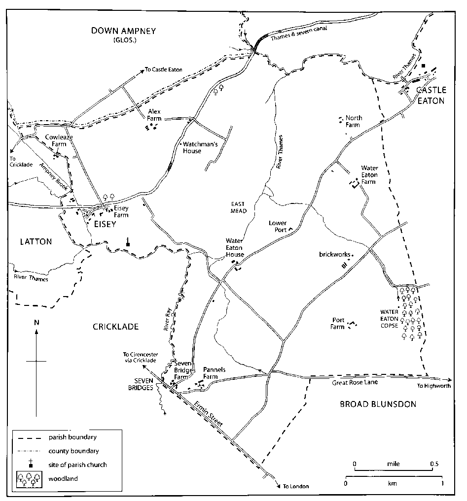
MAP 13. Eisey parish c. 1850. Eisey tithing lay in the western half of the parish, Water Eaton tithing east of the Thames.
UNTIL 1896, when the entire parish was added to Latton, (fn. 1) Eisey (frequently spelled Eysey) occupied flat land in the valley of the upper Thames. (fn. 2) Its two small medieval settlements, Eisey close to the north bank, and Water Eaton, close to the south bank of the Thames, have both dwindled to single farm complexes, and there are scattered cottages and small farmsteads elsewhere in the former parish. It adjoined Cricklade parish to the south and lay c. 12 km. south-east of Cirencester and c. 10 km. north-west of the centre of Swindon. The lands of Eisey and Water Eaton were contiguous, and by the earlier 12th century a church had been built at Eisey and a chapel dependent on it at Water Eaton. About 1195 an agreement between the owner of Eisey church and the lord of Water Eaton manor confirmed that Eisey's was the mother church and that Water Eaton was part of Eisey parish. (fn. 3) The parish measured 2,516 a. (1,018 ha.), of which Eisey had c. 895 a. and Water Eaton c. 1,620 a. (fn. 4)
Boundaries
The boundary around the lands of Eisey and Water Eaton became the parish boundary; the boundary between them followed the Thames. (fn. 5) Eisey's boundary followed watercourses for its entire length; Water Eaton's followed watercourses for about half its length, and for the other half was marked by fairly straight lines.
On the west Eisey's boundary with Calcutt (in Cricklade) followed the Thames for c. 1 km., and its boundary with Latton followed the main course of Ampney brook, a minor course of Ampney brook, and small streams flowing into the Thames and the brook. About 1805 the course of one of the streams was straightened and the boundary moved to the new course. On the north Eisey's boundary with Down Ampney (Glos.) and Marston Meysey followed a stream or a man-made ditch which linked Ampney brook and the Thames. (fn. 6) On the west Water Eaton's boundary with Calcutt followed the Ray, a tributary of the Thames, and on the north its boundary with Marston Meysey and Castle Eaton followed the Thames for c. 1 km. On the south its boundary with Widhill (in Cricklade until 1934) was marked by a Roman road, Ermin Street, and part of that with Broad Blunsdon was marked by a track, also probably of Roman origin. (fn. 7) The long eastern boundary between Water Eaton and Castle Eaton may have been drawn across pasture land which the inhabitants of the two places formerly used in common.
Landscape
The rivers and streams which bound and cross Eisey parish have made extensive deposits of gravel and alluvium. Oxford Clay underlies the deposits, and it outcrops where the land is higher. (fn. 8) On Eisey's land, north-west of the Thames and crossed by the main course of Ampney brook, the clay outcrops as an arc near the river; in three places gravel deposits lie on top of the clay. There are extensive deposits of alluvium between the clay and the river along the boundary with Water Eaton, and extensive deposits of gravel between the clay and the boundary with Down Ampney; elsewhere the deposits of alluvium are less extensive. Commercial extraction of gravel was in progress in 2009 between Alex farm and Eisey manor. Eisey's highest point is on the ridge of clay at 87 m.; its lowest point is on the Thames at 77 m. The alluvium beside the Thames was the site of a large commonable meadow; elsewhere there were open fields and commonable pastures on the clay and gravel. (fn. 9)
The clay outcrops over most of Water Eaton, where the highest land is at 85 m. in the south corner. The Thames has deposited alluvium in the north corner, where Water Eaton's lowest point is at c. 76 m. There are small deposits of alluvium elsewhere beside the Thames and beside the Ray, and gravel lies on top of the clay in several places near the rivers. Although there were open fields at Water Eaton in the Middle Ages pastoral farming was long preferred to arable farming on the clay land. (fn. 10)
Communications
Roads
Ermin Street, the Roman road which
marked the south-west parish boundary, led from
Gloucester and Cirencester to London via Speen
(Berks.) and Silchester (Hants.). (fn. 11) It remained in use as
a main road and was turnpiked in 1756 and
disturnpiked in 1876. As part of the main
London–Hereford road via Hungerford (Berks.) it was
designated a trunk road in 1946, and in 1987 it was given
a second carriageway. (fn. 12)
A road diverging from Ermin Street at Seven Bridges may have originated as a Roman trackway. (fn. 13) It was locally known as Port Way and probably took traffic between Highworth to the east and Cricklade and Cirencester to the west. (fn. 14) If so, its use declined after a road linking Highworth to Ermin Street at Broad Blunsdon was turnpiked in 1756. (fn. 15) The old road from Seven Bridges survives as a footpath and bridleway and, where it marks Water Eaton's southern boundary, as a track called Great Rose Lane. (fn. 16)
Other roads in Eisey parish served local needs. Stepping stones, some of which survived until the 20th century, afforded dryshod travel across the Thames between Eisey and Water Eaton; they were described as old in 1307. (fn. 17) Until the Cricklade bypass was built in 1975, there was no road bridge over the Thames between Castle Eaton and Cricklade. Eisey could only be reached from Cricklade by a lane branching south from a northern Cricklade to Kempsford (Glos.) road; this lane to Eisey runs straight across commonable pasture and may have been made when it was inclosed. (fn. 18) Most of the farmsteads of Water Eaton were reached by a road running between Castle Eaton and Seven Bridges. (fn. 19) In 1853 most of that road was replaced by a new straight section of road diverging from it a little north of a small farmstead called Lower Port and running south to a new junction with Ermin Street at Seven Bridges. The south section of the old road, and some of the lanes which were an alternative to it, were stopped; some survive as footpaths and others have disappeared. (fn. 20)
Canal
The Thames & Severn canal was opened
across the parish in 1789. It bisected Eisey's land and
was bridged in the village near Alex Farm, where a lock
was built, and c. 1831 a watchman's house at the lock. (fn. 21)
There was little traffic on the canal from the 1860s and
it was abandoned in 1927. (fn. 22) The watchman's house, a
rectangular stone tower, survived as a ruin in 2004.
Population
In 1377 Eisey had 32 poll-tax payers and Water Eaton had 64. (fn. 23) The parish had an adult population of c. 54 in 1676 and a population of 124 in 1801. (fn. 24) The population of the parish had risen to 164 by 1811 and to 194 in 1821, when Eisey had 136 inhabitants and Water Eaton 58. The population of Eisey fell from 137 in 1841 to 95 in 1851, a decrease attributed to emigration. The population of Water Eaton rose from 51 in 1841 to 67 in 1851. Eisey's decline continued during the 1860s as old cottages were demolished, and Water Eaton continued to grow as new ones were constructed. In 1871 the parish had 206 inhabitants but numbers fell sharply to 128 in 1891. (fn. 25) At Eisey there were 52 inhabitants in 1901 but only five dwellings in 2004. At Water Eaton there were 78 inhabitants in 1901 and c. 25 houses in 2004. (fn. 26)
SETTLEMENT
Early Settlement
Prehistoric activity in the parish is indicated by six round barrows of probable Bronze-Age date surviving as ring ditches near Eisey Field Copse; and by cropmarks of an undated but probably prehistoric extensive settlement complex in the same area. (fn. 27) Excavations during 1999 discovered occupation evidence of at least three Early Iron Age agricultural settlements, including a large rectilinear enclosure, north and west of the site of Eisey village. (fn. 28) By comparison with Latton, where evidence of RomanoBritish activity is plentiful, this period is scantily represented at Eisey, although scatters of pottery have been found south of Port Farm in Water Eaton. (fn. 29) Two circular enclosures of the Highworth type in the same area are probably medieval. (fn. 30)
Eisey
The Anglo-Saxon focus of settlement was probably the prominent ridge of high ground, east of the confluence of the Ampney brook and the Thames, on which its medieval church stood. The second element of Eisey's name, recorded in 855, means an 'island' of dry land and doubtless refers to this ridge; the first element is obscure but if, as has been suggested, it derives from a word for a deity, the choice of site may result from the christianization of a pagan religious place. (fn. 31) Buildings, which may have included a demesne farmstead, stood west and north-west of the ridge summit. (fn. 32) By the 18th century the village focus had shifted further north-west and the church, c. 350 m. south-east of the existing farmsteads, had become isolated. (fn. 33) In the early Middle Ages the village may have consisted of c. 15 small farmsteads, a number which would have been reduced in the later Middle Ages, and in 1540 Eisey was probably a village of about eight farmsteads. (fn. 34) In 1711 there were six farmhouses in the village. Eisey Farm, described as a chief messuage, had seven rooms on the ground floor and five on the first; the others had between three and five rooms on the ground floor and each had rooms on a first floor. (fn. 35) There was a vicarage house until the 18th century. (fn. 36)
In 1849 the only farmhouse in the village was that of Eisey farm. There were then 19 cottages, some perhaps divisions of former farmhouses, and a further eight gardens, centred on a triangle of roads west of the farm. All except two cottages and a few farm buildings stood south of the canal. (fn. 37) The number of cottages declined in the later 19th and 20th centuries, (fn. 38) and the church was demolished in 1953; (fn. 39) in 2009 Eisey Farm, including a farmhouse, and a small stone house of the late 18th century were all that remained of Eisey village.
Eisey farmhouse was rebuilt on a new site between 1849 and 1875. (fn. 40) The new stone three-storeyed house was built on an L-plan in 17th-century style. In 2004 the farmstead included stone farm buildings of the 19th century or earlier.
Away from the village Alex Farm had been built by 1711, when the farmhouse had five ground-floor and five first-floor rooms. (fn. 41) The farmhouse standing in 1849, perhaps the same one, was largely demolished between 1898 and 1920, (fn. 42) and replaced by a small mid-20th century house. The farmstead includes a stone barn with a Welsh slate roof, evidently built in the early 19th century and consisting of two 11-bayed naves. The north nave is divided into three sections and has a midstrey (or porch) which incorporates a single flue and a stone turret for a clock and a bell; the south nave has large segmental openings and a gabled midstrey. The farmstead also includes an early 19th-century cattle shelter and later buildings. In the 19th and 20th centuries farm buildings also stood beside a bridge over the canal east of Alex farm. (fn. 43) At the junction of the lane to Eisey and the Castle Eaton to Cricklade road a pair of estate houses was built in the mid 20th century.
Water Eaton
In common with similarly named settlements Eaton may imply a special function connected with its river, such as maintaining a ferry or passage; the affix, first recorded in 1395, served to distinguish it from its neighbour Castle Eaton lying to the east. (fn. 44) Water Eaton was alternatively called West Eaton, and sometimes Nun Eaton because it belonged to the abbey of Godstow (Oxon.). (fn. 45) The chapelry seems always to have served a dispersed and sparse community, although a field still referred to in 1943 as 'The Old Town' suggests a degree of nucleation. (fn. 46) Land west of Water Eaton House contains earthworks and has yielded medieval coins and artefacts. (fn. 47) On its southern boundary Ermin Street crossed the Ray on a series of causeways running for c. 250 ft., supported in 1829 by four arches. (fn. 48) The crossing, referred to as Seven Bridges in 1686, consisted of two farmsteads in the 18th century, and was then known as Water Eaton. (fn. 49)
The position of the farmstead referred to in the 16th century as the site of the manor (fn. 50) and in the 17th century as a chief messuage, is likely to have been near Water Eaton chapel. (fn. 51) The foundations of this chapel, which existed from the 12th century to its demolition c. 1673, survived close to Water Eaton House in 1943. (fn. 52) Water Eaton House, (fn. 53) called Manor Farm in 2004, stood north of its farm buildings. (fn. 54) The house built c. 1700 was replaced by a new house built in 1905. (fn. 55) The old house, of stone with a symmetrical façade and cross-mullioned windows, had two storeys and five bays and c. 1900 had a wing of one storey and a half. (fn. 56) The new house, which was built on a site south of the old one, is of three bays and of two storeys and attics, has rock-faced stone walls and a red-tiled roof, and is in a free style unusual for a farmhouse. It stands south of extensive 20th-century farm buildings.
South Farm, called Water Eaton Farm in the 18th century, remained a large farmstead until c. 1990, when its buildings ceased to be used for agriculture. The farmhouse is a stone building on an irregular plan and with a stone-slated roof. Most of what in 2004 was a south-west range of two storeys and attics with dormers has walling in which courses of large dressed blocks alternate with courses of small dressed blocks. The range was apparently built in the late 17th or early 18th century; it was evidently extended north-west by two bays, rendered, and given sash windows in the early 19th century, and later in the 19th century bay windows were added on the ground floor. Between 1972 and 1974 a north-east range was rebuilt as an entrance range in a gabled Cotswold idiom, and the south-east and north-east façades of the older range were altered in the same style. In the late 20th century an entrance porch was added on the north-west and nearly all the windows were replaced. (fn. 57)
There were two farmsteads at Seven Bridges in the 18th century, and farmsteads may long have stood on their sites. (fn. 58) The farm called Pannels Farm in 1850 was later called Seven Bridges Farm. (fn. 59) Its farmhouse, built mainly of stone, has a main block of five bays with a principal south front, and is of two storeys with attics. At its east and west ends the house incorporates fragments of one or possibly two mid 17th-century buildings. A low two-storeyed block to the east contains chamfered beams and a chamfered lintel with run-out stops; the two western bays of the main block contain a ground-floor room with a 17thcentury fireplace and a chamfered bridging beam with big ornamental stops, and there is a hollowmoulded stringcourse on the west gable end. At the west end of the house a north extension of one storey and a half was built in the 18th century, possibly as a dairy. The centre part of the main block was rebuilt in squared coursed rubble probably in 1876, when £400 was spent on the house; (fn. 60) also in the later 19th century a red-brick north wing containing a cheeseroom and a dairy was added at the east end. A covered way at the back was enclosed in the late 20th century. (fn. 61) Between 1850 and 1875 the second farmstead, east of Pannels Farm and called Seven Bridges Farm in 1850, largely went out of use. (fn. 62) On its site in 2004 a 17thcentury stone house, which was extended westwards in the 18th century and in which chamfered beams survive, (fn. 63) was incorporated in a two-storeyed row of three cottages built of stone rubble in the late 18th or early 19th century.
Two new farmsteads were built between c. 1805 and 1812, Port Farm south of Water Eaton Farm, and North Farm to the north. (fn. 64) In 2004 the site of Port Farm was occupied only by farm buildings, the farmhouse having been demolished c. 1970. (fn. 65) The farmhouse of North Farm was rebuilt in the mid 19th century as a single-pile house of three bays, rendered brick, and two storeys and a half; its outbuildings were not used for farming in 2004. Between Water Eaton Farm and Port Farm a pair of cottages at a brickworks had apparently been built by 1846 and were demolished between 1875 and 1898. (fn. 66)
In 1875 a pair of cottages stood beside the north-east section of the Castle Eaton to Seven Bridges road, and by then two pairs had been built since 1853 beside the new south-west section. The pair to the north-east bears a stone inscription recording thanks for an escape from a cattle plague of 1866; the cottages may be of that date. Lower Port Cottages, one of the two pairs, was part of a small farmstead; (fn. 67) like the other pair to the south-east it was a single house in 2004. Off the road and near Water Eaton Farm a house built between 1828 and 1846 (fn. 68) had been greatly extended by 2004.
New housing has been built at Water Eaton along the Castle Eaton to Seven Bridges road. On the southeast side a house was built near Castle Eaton c. 1930 and two small bungalows were built near Seven Bridges Farm in the later 20th century. On the north-west side a bungalow was built in the early, and four pairs of farm cottages in the mid 20th century.
MANORS AND ESTATES
EISEY
A five-hide estate at Eisey was among grants of land made to the bishop of Worcester by Burgred, king of Mercia, in 855. (fn. 69) The subsequent descent of this estate, granted before the region came under Wessex control, is obscure.
A thegn held Eisey in the reign of Edward the Confessor, and another thegn held Latton. Both estates were acquired by Earl Harold who united them, perhaps in 1066. (fn. 70) From 1066 to c. 1918 the land of Eisey and Latton descended together. It was held by Rainbold, a priest c. 1067, and from 1133 to 1539 by Cirencester abbey, and it later descended in the Hungerford, Dunch, and Eliot families. The single estate, consisting of nearly all of Eisey's and Latton's land, was usually called Latton and Eisey manors and sometimes Latton and Eisey manor. (fn. 71)
In 1714 Edmund Dunch, the lord of the manors, sold the reversion of the holding later called Eisey farm, c. 163 a., to Edward Massey Lawrence (d. 1727), the son of the tenant for life. Despite claims by his sister Anne Lawrence and her devisee, the farm passed under Edward's will to his first cousin once removed, Littleton Lawrence, who in 1738 sold it to Thomas Bush, (fn. 72) later the lord of Little Chelworth and Great Chelworth manors in Cricklade. Bush (d. 1786) devised his estate to John Adams and John's six sisters as tenants in common, (fn. 73) and in 1793 the devisees or their heirs sold Eisey farm to Francis Webb. (fn. 74) About 1800 the farm passed to Edward Craggs Eliot, Lord Eliot, presumably by purchase from Webb, and was reunited with the manors. (fn. 75)
In 1715 the reversion of a farm held for life by Elizabeth Clarke was sold by Edmund Dunch to Edmund Clarke. Clarke (fl. 1762) devised the farm to Edward Fletcher and his wife Elizabeth for life and to Edward's son Edmund Fletcher. (fn. 76) About 1787 the farm passed from Edward to Edmund Fletcher, who sold it to Edward, Lord Eliot, c. 1802. (fn. 77) It was reunited with Latton and Eisey manors.
In the early 20th century nearly all of Eisey's land lay in Eisey farm and Alex farm. Eisey farm, c. 644 a. including 197 a. at the south-west end of the old Latton parish, (fn. 78) was sold c. 1918 by John Eliot, earl of St Germans, to Henry Horton (d. 1924). It passed from Henry to his son Charles Horton (fn. 79) who c. 1940 sold it to Elfrida (d. 1963), the wife of Sir Orme Clarke Bt. The farm passed to Elfrida's son C. F. O. Clarke, the trustees of whose own son, W. O. Clarke, owned it in 2004. (fn. 80) Alex farm, c. 403 a., was sold c. 1918 by Lord St Germans to John Rickards (fn. 81) (d. 1927), (fn. 82) whose executors owned it in 1933. (fn. 83) By 1942 it had been acquired by H. H. and C. D. Gantlett (fn. 84) and by 1955 by the Co-operative Wholesale Society, (fn. 85) the owner in 2004. (fn. 86)
WATER EATON MANOR
The land was held in 1066 by Edric and in 1086 by Herman de Drewes, a serjeant of the king. (fn. 87) In the early 12th century it was held by Reynold, son of Roger de Breteuil, earl of Hereford, who, with his wife Emmeline, daughter of Hamelin de Ballon, lord of Abergavenny, gave it to Godstow abbey (Oxon.) c. 1142. (fn. 88) The abbey held Water Eaton manor until 1539, (fn. 89) when the abbey was dissolved and the manor passed to the Crown. (fn. 90)
In 1540 Water Eaton manor was sold by the Crown to Sir John Bridges (Baron Chandos from 1554, d. 1557), (fn. 91) and it descended in turn to his son Edmund, Lord Chandos (d. 1573), (fn. 92) and Edmund's son Giles, Lord Chandos (d. without male issue 1594). (fn. 93) Giles's heir was his brother William, Lord Chandos (d. 1602), and William's was his son Grey, Lord Chandos. After dispute, in 1605 the manor was settled by Act for life on Giles's relict Frances (d. 1623) with reversion to Lord Chandos. In 1616 it was sold to Edward Sheldon. (fn. 94)
The manor passed from Edward Sheldon (fl. 1640) to his grandson Ralph Sheldon, (fn. 95) who in 1671 sold it to Sir Stephen Fox. (fn. 96) From Fox's death in 1716 it was held by his relict Christian. On her death in 1719 it passed to Fox's son Stephen (Baron Ilchester from 1741, earl of Ilchester from 1756), who took the surname FoxStrangways in 1758 and died in 1776. The manor descended to Stephen's son Henry Fox-Strangways, earl of Ilchester (d. 1802), who in 1801 contracted to sell it to Richard Hart Davis. The sale was completed in 1804. (fn. 97) Between 1805 and 1812 Davis sold the manor in portions.
In 1805 Davis sold c. 746 a., the land later of the farm worked from Water Eaton House (Manor farm) and of Seven Bridges farm, to Thomas Jones (fn. 98) (d. by 1826). The estate was offered for sale in 1828, probably by Jones's executors, belonged to T. P. Williams in 1833, and was acquired by Walter MacGeough-Bond apparently by purchase from Williams c. 1839. (fn. 99) MacGeough-Bond (d. 1866) was succeeded by his son Ralph MacGeoughBond-Shelton (d. 1916, without issue), (fn. 100) the owner in 1914. (fn. 101) The farms were apparently sold to the tenants c. 1916, and in 1924 Manor farm, 414 a., belonged to D. J. Gantlett. (fn. 102) In 1954 Gantlett sold Manor farm to M. C. Lewis (d. 2000), who bought 200 a. at Calcutt in the 1970s, 630 a. of South farm in 1991, and 40 a. of South farm shortly before 1991. All that land was added to Manor farm, which in 2004 was of 1,300 a. and belonged to Lewis's son Mr D. C. Lewis. (fn. 103) Seven Bridges farm, 364 a. in 1924, (fn. 104) was bought by David Gantlett; it descended to his son R. J. Gantlett, whose son Mr E. R. Gantlett owned it in 2004. (fn. 105)
In 1807 Richard Hart Davis sold Port farm, 294 a., to James Whittingham (fn. 106) and in 1812 sold 511 a., the land later of North farm and South farm, to Sir Thomas Tancred Bt (d. 1844); also in 1812 Sir Thomas bought Port farm. Sir Thomas's estate descended to his son Sir Thomas Tancred Bt (d. 1880), (fn. 107) and by 1903 had been acquired by W. F. Hicks Beach (d. 1923). (fn. 108)
In 1913 Hicks Beach sold South farm, 442 a. in 1924, to David Gantlett, from whom it passed to his son H. H. Gantlett. (fn. 109) In 1957 Gantlett sold it to Janine SebagMontefiore, who in 1965 sold it to Ross Whittall. About 1970 Whittall enlarged the farm to 616 a. and in 1972 sold it to H. R. Ingram. In 1979 Ingram sold the farm to Mr N. A. G. Laing, who enlarged it to c. 750 a. in 1980. In and shortly before 1991 Mr Laing sold 670 a. to M. C. Lewis, who added it to Manor farm, and in 1998 he sold South Farm and c. 50 a. to Mr and Mrs J. Summer, the owners in 2004. (fn. 110)
By 1924 North farm, 150 a., had been acquired by Thomas Green, (fn. 111) who owned it until his death in 1976. In 1980 the farm was bought from Green's executors by Mr N. A. G. Laing, who added most of its land to South farm. (fn. 112) In 1924 Port farm, 193 a., belonged to Mrs Kate Hiett, (fn. 113) and in 1942 it belonged to S. S. Hiett and Mrs A. L. K. Dodd. (fn. 114) It was afterwards bought by R. J. Gantlett, who added part of it to Seven Bridges farm; the rest of Port farm was bought c. 1970 by Ross Whittall and added to South farm. (fn. 115)
RECTORY ESTATE
Eisey church and the chapel at Water Eaton were given with the lands of Eisey and Latton by Henry I to Cirencester abbey in 1133, (fn. 116) and the Rectory estate belonged to the abbey until the Dissolution. (fn. 117) At the time of the gift the estate probably consisted of the tithes arising in Eisey and Water Eaton and of 2 yardlands at Water Eaton. It was apparently diminished when Clement III (pope 1187–91) gave the small tithes of Water Eaton to Godstow abbey, the lord of Water Eaton manor. About 1195, however, it was augmented when, as part of an agreement with Cirencester abbey concerning burial at Water Eaton and the performance of services in the chapel, Godstow abbey gave an additional 2 yardlands at Water Eaton. (fn. 118) The small tithes of Eisey may have been assigned to the vicar of Eisey when the vicarage was ordained and, to settle a dispute between Cirencester abbey and the vicar, in 1325 the bishop of Salisbury ruled that the vicar should pay 20 marks a year to the abbey and in return have the 4 yardlands at Water Eaton and receive the great tithes from the whole parish. (fn. 119) Either the parties did not follow the ruling or the ruling was varied. It is likely that the abbey forsook the yearly payment in return for all the tithes from its demesne at Eisey, for the great tithes from Water Eaton, and for the 4 yardlands. There is no evidence that the payment was made.
From the 16th century or earlier the vicar of Eisey took the great tithes of most of Eisey. (fn. 120) The tithes arising from Cirencester abbey's demesne there were apparently merged with the land, and in the 19th century land deemed to have been the abbey's demesne was tithe-free. (fn. 121)
The remainder of the Rectory estate, then consisting of the great tithes of Water Eaton and c. 100 a. of meadow in Water Eaton, passed to the Crown in 1539 when Cirencester abbey was dissolved. (fn. 122) In 1541 the Crown granted it to Sir Thomas Seymour, (fn. 123) who in the same year sold it to Virgil Pleydell (fn. 124) (d. 1558). It descended to Virgil's son John Pleydell, a minor, who entered on it in 1575. (fn. 125) In 1598 John sold the tithes to Richard Younger (fn. 126) and in 1599 sold the land to Anthony Hungerford (fn. 127) (knighted in 1608, d. 1627). (fn. 128) The tithes were afterwards acquired by Grey Bridges, Lord Chandos, and, with Water Eaton manor, were conveyed to Edward Sheldon in 1616. (fn. 129) They descended with the manor and in 1844–5 were declared by the landowners to have been merged with the land from which they arose. (fn. 130) The land sold in 1599 passed in turn to Sir Anthony Hungerford's son Anthony (fn. 131) (d. 1657) and Anthony's son Sir Edward, who in 1674 sold it to Sir Stephen Fox, the lord of Water Eaton manor. (fn. 132) The land was thereupon merged with the manor.
In 1236 the parson of Eisey, either the vicar or the chaplain appointed by Cirencester abbey, claimed the tithe of hay and of mills from Godstow abbey's demesne at Water Eaton. Godstow abbey retained those tithes and, to settle the claim, gave 3 a. of meadow and 3 qr. of corn a year to the parson. (fn. 133) In 1296 the parson, presumably the vicar, claimed tithe of hay from Roger of Writtle, who apparently held Water Eaton manor as Godstow abbey's tenant; Roger agreed to pay 10s. a year in place of such tithe for the period of his tenure. (fn. 134) The small tithes of Water Eaton were not expressly mentioned at the Dissolution. (fn. 135) Presumably the right to receive them passed with Water Eaton manor from Godstow abbey to the Crown and descended with the manor. The declarations of 1844–5 that the tithes of Water Eaton had been merged covered the small tithes. (fn. 136)
ECONOMIC HISTORY
AGRICULTURE
Because their lands lay on opposite banks of the Thames, Eisey and Water Eaton were always farmed as separate entities, and their agricultural histories are distinct.
Eisey
Eisey and Latton were assessed jointly in 1086 at nine hides, when they had land for eight ploughteams. The demesne land was assessed at three hides on which there were three teams and eight households of servi; 15 villani, six bordars, and four cottars shared five teams. There was 200 a. of meadow and there was half a square league of pasture. (fn. 137) Later evidence suggests that about a third of the land and of the tenants' farmsteads lay at Eisey. (fn. 138)
Eisey had c. 880 a., (fn. 139) apparently nearly all of which was commonable until the 17th century. The area was small, the number of farms was low and the layout of the land for agriculture was simple. Open fields, c. 220 a., apparently lay in the centre; south-east of them Eisey or East mead, 138 a., lay along the left bank of the Thames east of the village, and north-west of them a pasture called the Moor probably lay along Eisey's north boundary and was probably of c. 400 a. The boundary between the open fields and the Moor may have been roughly the line followed by the Thames & Severn canal. (fn. 140) Besides the home closes of the farmsteads in the village the only inclosure before the 17th century seems to have been that of demesne land called Farm close and Aldwicks (later Alex); Farm close was of c. 20 a. and Aldwicks was a pasture apparently inclosed from the Moor. (fn. 141)
In the Middle Ages demesne land at Eisey may have been worked from a farmstead near the church. (fn. 142) In the early 16th century Cirencester abbey kept in hand the first cut of 165 a. of East mead, Southam mead, and Russhey mead, adjoining and commonable meadows in respectively Eisey, Latton, and Calcutt, and then or earlier the hay was cut, made, and carried partly by the labour of customary tenants; perhaps c. 65 a. of the 165 a. lay in East mead. (fn. 143) By 1540, however, the demesne arable, if there had been any, had apparently been added to customary holdings at Eisey, and Farm close and Aldwicks had been added to the demesne farm worked from Latton; already by then the demesne farmstead at Eisey, if there had been one, had probably been demolished. There were probably c. 15 small customary holdings at Eisey in the Middle Ages. By 1540, when there were eight messuages, seven tofts, and customarily held land assessed at 10½ yardlands, the number had been reduced to seven. (fn. 144) The high proportion of grassy lowland apparently favoured cattle rearing at Eisey. Cattle were fed on the Moor, in an upper part of which some customary tenants had feeding rights for 10 or more, and they were kept in the open fields at certain times; although they may have been temporary, in 1593–4 restrictions were placed on the feeding of sheep in East mead and the Moor and, as at Latton, to sublet feeding rights to sheep drivers was forbidden. (fn. 145)
The Moor, used in common in 1593, had been inclosed and divided by 1647. (fn. 146) By the mid 17th century all but one of the copyholds, and the reversion of the last, had been converted to leasehold on lives, and new closes were probably added to each holding. In 1654 there were probably about five farms with buildings at Eisey. (fn. 147) In 1663 that later called Eisey farm was of c. 175 a. and included 99 a. in nine closes, 56 a. in the open fields, and 20 a. in East mead. (fn. 148)
In 1711 Eisey's open fields lay as Home field, 79 a., Mead field, 67 a., and Far and Alex fields, 75 a.; Eisey mead remained commonable and c. 400 a. lay in closes. There were seven farms. By 1703 closes formerly part of the Moor had been accumulated as Alex farm, the farmstead of which was presumably built on the demesne pasture called Aldwicks; in 1711 the farm, which included no open-field arable and only 6 a. of Eisey mead, was of 206 a. including 75 a. in Down Ampney. Eisey farm was then of 163 a. and included 55 a. of open-field arable, 17 a. in Eisey mead, and 91 a. in c. 10 closes. The other farms were of 163 a., 105 a., 85 a., and 72 a. and all included more several land than commonable; with Eisey farm they shared the right to feed 24 horses, 114 cattle, and 500 sheep in the open fields and Eisey mead. The farmsteads, other than Alex farm, stood in the village; they included two dairies, a cheese room, two cowhouses, four brewhouses, and three malthouses. (fn. 149)
Eisey's open fields were all apparently inclosed by private agreement, between 1738 and 1786. (fn. 150) In the late 18th century there may still have been three or four farms in Eisey besides Eisey farm, which was of 200 a. or more in 1793, and besides Alex farm. (fn. 151) In c. 1802 land of Eisey manor sold in the early 18th century was bought back by the lord of the manor (fn. 152) and lifehold tenure of land of the manor apparently ended. When common rights over East mead were eliminated by Act in 1805 the lord of the manor was already entitled to nearly all of them and acquired the rest by exchange. (fn. 153) East mead was not divided into small fields and was added to Alex farm, and by 1808 the number of farms at Eisey, including Alex farm, had apparently been reduced to three. About 1808 Alex farm was of 367 a., including 74 a. of arable, (fn. 154) and in 1820 Eisey farm was of 417 a. including the 25 a. of Russhey mead in Calcutt from which the tenant took the first cut. (fn. 155)
In 1849 there was c. 440 a. of arable and c. 400 a. of meadow and pasture at Eisey. Eisey farm included 396 a. of Eisey's land of which c. 225 a. was arable; Alex farm included 358 a. of which c. 185 a. was arable. Farm buildings north-west of Eisey farm and 55 a. in the west angle of the canal and the lane to the farmstead were held with Cowleaze farm in Latton, a total of c. 165 a.; (fn. 156) by 1875 the buildings at Eisey had been demolished and the land was presumably worked then from Cowleaze Farm in Latton. (fn. 157)
In 1903 Alex farm was of 396 a.; by then Eisey farm had been increased to 643 a. by the addition of 117 a. of Southam mead in Latton and by the buildings and most of the land of Cowleaze farm. (fn. 158) Eisey farm was held as tenant and afterwards as owner by Henry Horton, who specialized in dairy farming and was the first chairman of the Wiltshire executive of the National Farmers' Union. (fn. 159) Both Eisey farm and Alex farm, which still included nearly all of East mead, (fn. 160) were presumably dairy farms. The two farms had changed little in area by 2004. In 1941 Eisey farm included 203 a. of arable and 443 a. of grassland and there was on it a dairy herd which included 84 cows in milk and 80 cows and heifers in calf. In 1942 Alex farm was of 426 a. and included 106 a. of arable. (fn. 161) Eisey farm, on which Cowleaze Farm was demolished c. 1960, was leased to the Royal Agricultural College, Cirencester, in 1969. The college, which remained the tenant in 2004, converted the farm from a dairy farm to an arable and beef farm and erected large new buildings at the farmstead; it managed the farm as a commercial enterprise and to provide practical demonstrations of farming techniques and estate management. Cattle rearing ceased in 2000. In 2004 oil seed rape was grown on c. 306 a. and wheat on 209 a.; c. 100 a. was meadow land. (fn. 162) In the later 20th century Alex farm was managed directly by the Co-operative Wholesale Society and used for arable and dairy farming. In 2002 it was leased as a dairy farm of c. 350 a. (fn. 163)
Water Eaton
In 1086 Water Eaton was assessed at two hides and had land for two ploughteams. There was both demesne land, on which there was one team, and customary land, which was held by one villanus, two bordars, and two coscets and on which there was also one team. There was 2 a. of meadow. (fn. 164)
There were open fields at Water Eaton in the 12th century and almost certainly commonable pastures. The open fields were called South and East and had in them demesne land, some of which was used as meadow. (fn. 165) In the Middle Ages the land was probably worked from a demesne farmstead, presumably on the site of either that called South Farm in the 20th century or that called Manor Farm in the 20th century, and from copyhold farmsteads at Seven Bridges or elsewhere. Water Eaton had twice as much land as Eisey, and its farms were therefore either more numerous, larger, or with rights to feed more animals in common.
In c. 1195 the land of the Rectory estate in Water Eaton was assessed at 4 yardlands and included openfield land. (fn. 166) By the early 16th century it consisted mainly of 80 a. of pasture belonging to several holdings, revealing that the old commonable agriculture had been superseded. (fn. 167) A list of the lands of the manor made in 1617 includes no open field, (fn. 168) and a claim made in 1705 by the vicar of Eisey to pasture rights for 1 cow in the town leaze from May day to Michaelmas is the only post-medieval reference to land at Water Eaton being commonable. (fn. 169)
In the late 17th century nearly all of Water Eaton's land lay in six farms held for rack rents; the yearly rents were £454, £240, £210, £200, £110, and £35. The two largest farms were presumably those later called Water Eaton (South) farm and Water Eaton House (Manor) farm; the others presumably included farmsteads at Seven Bridges. In the 1770s there were four or five farms, (fn. 170) and in 1801 there were four, Water Eaton, 562 a., Water Eaton House, 498 a., Pannells, 283 a., and Seven Bridges, 204 a.; Pannells Farm stood immediately east of Seven Bridges Farm at Seven Bridges. In 1801 the farms included 390 a. of arable and 1,154 a. of grass; dairy farming was practised and each farm, or nearly all of it, was within a ring fence. (fn. 171)
About 1805 a new farmstead, known as Port Farm, was built and held with 294 a. and Water Eaton House farm had been reduced to 300 a. and Pannells farm to 239 a. By 1812 another new farmstead had been built and 152 a. leased with it as North farm, and Water Eaton farm had been reduced to 355 a. The 1,550 a. of the six farms lay in c. 75 closes of c. 20 a. each. (fn. 172) About 1845 Water Eaton farm included c. 80 a. of arable, and North farm included 36 a. of arable; (fn. 173) in 1850 Water Eaton House farm, 315 a., included 146 a. of arable, Pannells farm, 257 a., included 43 a. of arable, and Seven Bridges farm, 212 a., included 60 a. of arable. (fn. 174)
By 1867 Seven Bridges farm had been divided between Water Eaton House farm, then 414 a., and Pannells farm, then 367 a.; the farmstead of Pannells farm was afterwards renamed Seven Bridges Farm. In 1867 less than a third of each of the two farms was arable, (fn. 175) and some of that arable was laid to grass in the 1880s. (fn. 176) By 1903 Port farm had been added to Water Eaton farm, then of 635 a.; North farm was then of 149 a. (fn. 177) In the 1920s Port farm was again separate, Water Eaton farm was of 442 a. in 1929, (fn. 178) and there remained five farms until the later 20th century. The conversion of arable to grassland continued after the 1880s, and in 1936 Water Eaton's land was almost entirely meadow and pasture; (fn. 179) some land was restored to arable in the Second World War. The farms were then dairy farms, and on South, North, Manor, and Seven Bridges farms in 1941 there were 585 cattle including 316 cows in milk. (fn. 180)
There was arable, dairy, and mixed farming at Water Eaton in the later 20th century. By c. 1970 Port farm had been divided between South farm and Seven Bridges farm, and in 1980 most of North farm, which had been a dairy farm until the 1970s, was also added to South farm. Seven Bridges farm, c. 400 a., was a dairy farm until the early 1990s, and in 2004 it was a pasture farm on which cattle were reared. (fn. 181) South farm, 423 a. in 1965, (fn. 182) was a mixed farm of 616 a. in 1972 (fn. 183) and a mainly arable farm of c. 750 a. in the 1980s; its arable was set aside in 1987, and 670 a. of the farm was added to Manor farm in or shortly before 1991. (fn. 184) In 2004 Manor farm was an arable and dairy farm of 1,300 a.; it included 200 a. at Calcutt and large buildings at Water Eaton House and Calcutt. (fn. 185)
WOODLAND
There may have been little woodland at Eisey in 1586, when the court held for the lord of Latton and Eisey manors issued an injunction that three ashes and three elms should be planted yearly on each holding of land at Eisey, a total of c. 40 trees a year; (fn. 186) the injunction apparently had little long-term effect. In 1849 there was no more than 12 a. of woodland at Eisey. Two plantations beside the canal, a total of 5 a., were presumably made after 1789, and there were narrow plantations along Eisey's north-west boundary. (fn. 187) In the late 20th century another two small plantations were made, one near the site of Eisey church and one northeast of it. (fn. 188) All four plantations were standing in 2004.
In 1086 woodland at Water Eaton was said to cover 2 square furlongs. (fn. 189) In the 19th century the only woodland was Water Eaton copse, 23 a. in 1801, and small copses near Port Farm and Water Eaton House. (fn. 190) By 1846 Water Eaton copse had been increased to 32 a., (fn. 191) and between 1956 and 1966 one of the smaller copses was reduced from 3 a. to 1 a. (fn. 192) All three copses were standing in 2004.
TRADE AND INDUSTRY
Large-scale commercial gravel extraction was in progress in 2009 north of Eisey Manor and extending towards Alex Farm. This includes a gravel conveyor operating east-west across the site, over which a new bridge has been constructed to take the access road to Eisey Manor.
A brickworks between Water Eaton Farm and Port Farm had been opened by 1846. It apparently went out of use between 1875 and 1898. (fn. 193)
SOCIAL HISTORY
COMMUNITY ACTIVITIES
The low population and scattered settlement have restricted community life. Until sales in the 19th century and later landowners were rarely, if ever, resident in the former parish. Accommodation for travellers, presumably at an alehouse, was provided at Seven Bridges in 1686, but otherwise the parish has never had an alehouse, inn, public hall, or public recreation ground. (fn. 194)
EDUCATION
There has never been a public day school at Eisey or Water Eaton. In the 19th and 20th centuries children from Eisey went to school at Latton, where the school was built in 1832. (fn. 195) In the mid 19th century children from Water Eaton went to school at Cricklade; (fn. 196) later in the 19th century and in the 20th some or all of them attended Castle Eaton school. (fn. 197) A private school at Water Eaton which was opened in 1911 may have been short-lived. (fn. 198)
CHARITIES FOR THE POOR
No eleemosynary charity for the parish is known.
LOCAL GOVERNMENT
MANOR
Eisey
The men of Eisey, like those of Latton, may
already have been withdrawn from the jurisdiction of the
lord of Cricklade hundred by 1258, and in 1259 they were
formally exempted from suit at the courts of the hundred;
the lord of the hundred retained return of writs for Eisey
as for Latton. (fn. 199) In 1289 Cirencester abbey's claim to have a
tumbrel and gallows and to enforce the assize of bread
and of ale for Latton may have embraced Eisey. (fn. 200)
In the early 16th century Cirencester abbey apparently held a manor court twice a year and a view of frankpledge once a year for its combined estate of Latton and Eisey. (fn. 201) The records of a combined court and view held for the two places exist from 1584. (fn. 202) Officers from Eisey, a tithingman, a hayward, and two overseers of commons, were sworn. The few cases they presented usually related to stray animals or the misuse of commonable pasture; in 1593 the perpetrator of an assault and those who failed to carry stone to repair the roads were presented. The court regulated common husbandry and issued orders for the abatement of nuisances and misdemeanours. In 1592 all those holding land in Eisey were ordered to contribute to the costs and labour of building a new pound at Eisey. Very little property in Eisey was held by copy in the late 16th century, and there is only one extant recital of a conveyance of a copyhold there. (fn. 203)
In the 17th century the combined court and view dealt with very little Eisey business. A tithingman and a hayward continued to be sworn, (fn. 204) and in 1645 the court settled the question whether the occupant of a newly built house should serve in course as tithingman and as hayward by deciding, apparently in accordance with his wish, that he should. (fn. 205) In 1683 new or revised rules governing the grazing of the open fields and commonable meadow, agreed on by the landholders of Eisey, were recorded as orders of the court. (fn. 206) A tithingman and a hayward were sworn at the court in 1703. (fn. 207) Thereafter the court apparently ignored Eisey. (fn. 208)
Water Eaton
The vill of Water Eaton was amerced
by a Braydon forest eyre in 1209–10, so may then have
been regarded as within the forest and under its
jurisdiction. (fn. 209) The forest bounds in 1228 began and ended
at Water Eaton, following the rivers Thames and Ray,
thus placing the entire parish outside the bounds. (fn. 210)
The men of Water Eaton were under the jurisdiction of the courts of Staple hundred until 1232, when Godstow abbey withdrew them from it. (fn. 211) In 1275 the abbey was holding view of frankpledge for Water Eaton and enforcing the assize of bread and of ale there. (fn. 212) There is no direct record of the abbey's courts attended by the men of Water Eaton and, although the right to hold a view and to exercise leet jurisdiction in Water Eaton passed with Water Eaton manor in the 16th century, (fn. 213) it is unlikely that any view or court leet was held after the Dissolution.
PARISH
Eisey parish spent £58 on poor relief in 1775–6, an average of £55 in the three years ending at Easter 1785. In 1802–3, when at 1s. 7d. the poor rate was the second lowest in the hundred and the population was c. 124, 16 adults were relieved permanently and 20 people were relieved occasionally; £165 was spent, including £15 on materials to provide work for paupers. (fn. 214) In the three years ending at Easter 1815 on average 18 people were relieved permanently and on average 19 occasionally; expenditure fell from £320 in 1812–13 to £205 in 1814–15. (fn. 215) Between 1816 and 1835 yearly expenditure on the poor averaged c. £270; at £341 it was highest in 1816–17 and 1831–2 and at £212 lowest in 1825–6. (fn. 216)
Eisey joined Cricklade and Wootton Bassett poorlaw union at its formation in 1835 (fn. 217) and remained part of it as it became a rural sanitary authority and a rural district. (fn. 218) It was, with the rest of Latton parish, part of North Wiltshire district from its creation in 1974 to its abolition in 2009. (fn. 219)
RELIGIOUS HISTORY
PARISH CHURCH
There was a church at Eisey from the 12th century or earlier until 1953, and there was a chapel at Water Eaton from the 12th century or earlier until, probably, 1673. Both were appropriated by Cirencester abbey, to which they were given in 1133. (fn. 220) A vicarage of Eisey had been ordained by 1291. (fn. 221) In 1819 it was united to the vicarage of Latton. (fn. 222) In 1952 the vicarage of Latton with Eisey was united to the vicarage of St Sampson's, Cricklade, and the rectory of St Mary's, Cricklade, as the united benefice of Cricklade with Latton. Water Eaton was transferred from the ecclesiastical parish of Eisey to that of Castle Eaton, and the remainder of Eisey ecclesiastical parish was united to that of Latton. (fn. 223)
Advowson
The advowson descended with the Rectory estate and, until the Dissolution, with Latton and Eisey manors. From 1311, the date of the first surviving record of a presentation, until 1538 the abbot of Cirencester always presented the vicar. (fn. 224) In 1541 the advowson was granted with the Rectory estate by the Crown to Sir Thomas Seymour, (fn. 225) in 1598 it was sold with the great tithes of Water Eaton by John Pleydell to Richard Younger, (fn. 226) and in 1616 it was conveyed with the tithes and Water Eaton manor by Grey Bridges, Lord Chandos, to Edward Sheldon. (fn. 227) It descended with the manor to Richard Hart Davis, who sold the lands of the manor between 1805 and 1812 (fn. 228) and presented the vicar instituted in 1817. (fn. 229) Between 1817 and 1819 the advowson was acquired by John Eliot, earl of St Germans, the lord of Latton and Eisey manors, (fn. 230) and from 1819 to 1952 the patronage of the united benefice descended to John's successors as earl of St Germans. From 1952 the earl of St Germans was entitled to present at every third vacancy of the united benefice of Cricklade with Latton. (fn. 231)
Value and Property
The vicarage was valued at £5 in 1291, (fn. 232) £12 in 1535, (fn. 233) and £150 in 1819, (fn. 234) below average income for a living in Salisbury diocese. The small tithes of Eisey may have been assigned to the vicar when the vicarage was ordained; a claim made in 1296, similar to one made in 1236, failed to add hay tithes from Water Eaton to his living. In 1325, following a dispute between the abbey and the vicar, it was ruled that the vicar should have the great tithes from the whole parish and that he should pay 20 marks a year to the abbey. Later, however, the vicar apparently paid nothing to the abbey and took all the tithes from the land in Eisey held customarily of the abbey and no other tithe from the parish. (fn. 235) In 1848 the vicar's tithes arose on 510 a. of Eisey, were valued at £150, and were commuted. (fn. 236)
In 1325 it was ruled that the vicar should have a house, commonly called Rome and presumably standing in the parish, feeding rights on the commonable lands of Eisey equivalent to those for 1 yardland, and, all in Water Eaton, 4 yardlands, a croft, and a curtilage. Like the great tithes arising in Water Eaton and on Cirencester abbey's demesne in Eisey the 4 yardlands was apparently given up in exchange for the removal of the obligation to pay the 20 marks, and it was later part of the Rectory estate. (fn. 237) In 1588 and 1705 the vicar held as glebe a house, 6 a. of meadow and pasture, and no feeding right. (fn. 238) By 1783 the house was no longer standing, and in 1819 the vicar held 8 a. of glebe, all at Eisey. (fn. 239) The land was apparently sold between 1887 and 1903. (fn. 240)
The registers begin in 1574. There are small gaps in those of burials; those of marriages and baptisms are complete. (fn. 241)
RELIGIOUS LIFE
If a church stood at Eisey in the 11th or early 12th century, it may have been served by chaplains of a small minster at Cirencester. (fn. 242) From 1133 until a vicar was instituted it was probably served by chaplains employed by Cirencester abbey. (fn. 243) About 1195 Godstow abbey, the lord of Water Eaton manor, agreed with Cirencester abbey that the chapel of Water Eaton would be dependent on Eisey church and the inhabitants of Water Eaton would be buried in Eisey graveyard. Godstow abbey added to the endowment of Eisey church and in return Cirencester abbey agreed to provide services in Water Eaton chapel every Sunday, on holy days, throughout Lent, and on every Monday, Wednesday, and Friday. (fn. 244) After the vicarage was ordained, the vicar of Eisey served both the church and the chapel. (fn. 245) The vicars also employed stipendiary chaplains, including John Clark (d. c. 1404), who asked to be buried in the graveyard of the church he served. (fn. 246) In 1553 the parish had three bells, (fn. 247) a silver chalice weighing 6 oz., and other plate weighing 1½ oz. which was confiscated by the crown. (fn. 248)
Although the living included a house, (fn. 249) many vicars were not resident and served other livings as well. Humphrey Smith, vicar from 1570 to 1623, was rector of Castle Eaton from 1575 and probably lived at Castle Eaton. (fn. 250) A curate was serving Eisey church in 1584, when the churchwardens thought that he should wear a surplice more often. (fn. 251) Walter Jones was the vicar from 1643 to 1666. (fn. 252) Water Eaton chapel may have been served less regularly after the Reformation, and the building became neglected. In 1556 its doors and windows were defective, (fn. 253) in 1671 it was said to be wholly out of repair, (fn. 254) and in the 19th century it was said to have been demolished in 1673. (fn. 255) Edward Head, vicar of Eisey 1683–1725, was vicar of Latton from 1710. (fn. 256) The vicarage house at Eisey, out of repair in 1683 and 1756, (fn. 257) was no longer standing by 1783. Richard Goldesbrough, vicar from 1782 to 1816, lived at Bruton (Som.) in 1783; from 1784 he was bursar of Magdalen College, Oxford, and from 1793 dean of divinity in the university, and he probably lived at Oxford. In 1783 Eisey church was served by Edward Campbell, who lived at Cricklade where he served the two parish churches. At Eisey a service was held once every Sunday and communion was celebrated, with about seven communicants, four times a year. (fn. 258) In 1801 the churchwarden complained that there was sometimes no Sunday service. (fn. 259) From 1817 to 1819 the vicar was John Lyne, who may have lived at Down Ampney, was also vicar of Latton, and held a service at Eisey each Sunday. In 1819, after his death in that year, the two benefices were united. (fn. 260) From c. 1827 to 1948 the vicar of the parish of Latton with Eisey apparently lived at Latton. (fn. 261)
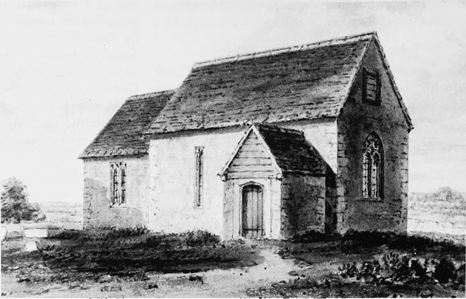
21. Parish church of St Mary from the north-west, c. 1810. Replaced in 1844, that church was demolished in 1953.
In 1844 Eisey church was rebuilt, (fn. 262) the bell of 1738 was hung in the new bellcote, (fn. 263) and in 1845 old items of plate were remade as a chalice, a paten, and a flagon. (fn. 264) In 1851 there was a congregation of 65 at the service on Census Sunday. (fn. 265) In the early 20th century there was usually a service on each Sunday, and an ante-communion service was held once a month. (fn. 266) The last marriage in Eisey church, and the last burial in the graveyard, took place in 1947, and the church was closed in 1948. (fn. 267) In 1953, when the church was demolished, Eisey's plate, (fn. 268) which in 1928 had included the chalice and the paten of 1845, (fn. 269) was added to Latton's. (fn. 270) The bell was transferred to the newly-built church of St Peter at Penhill, Swindon, consecrated in 1956. (fn. 271)
No Roman Catholic or Protestant Nonconformity is recorded in the parish.
CHURCH BUILDINGS
St Mary's Church
The church standing until 1844 was apparently built in the 14th century. It was two-celled and of stone rubble with a stone-slated roof. The nave was of two bays and had a west window with reticulated tracery and a single-light window in the east part of its north wall; a louvered opening in the west gable may have had a bell hanging behind it. The chancel was of one bay and had a square-headed north window. A gabled north porch, with weatherboarding in the gable, was added to the nave c. 1500. (fn. 272) The earliest date at which the church is known to have been dedicated to St Mary is 1763. (fn. 273)
The church built in 1844 consisted of a five-bayed nave with west bellcot and gabled south porch and of an apsidal ended chancel. It was built of dressed stone, had a stone-slated roof, and was in a simple neo-Norman style. (fn. 274) A Scheme of 1952 authorised the demolition of Eisey church, which took place in 1953. (fn. 275) The site was planted with trees in 1974, although gravestones in the former churchyard remained in 1994. (fn. 276)
St Laurence's Chapel
St Laurence's chapel at Water Eaton was so called in 1404. (fn. 277) It was apparently endowed with 2 yardlands to provide a living for a chaplain, which seem to have passed with the chapel to Cirencester abbey in 1133. In c. 1195 Godstow abbey endowed the chapel with two additional yardlands. (fn. 278) Despite a ruling of 1325 that the endowment should be held by the vicar of Eisey, it remained part of the Rectory estate. (fn. 279)