A History of the County of Wiltshire: Volume 18. Originally published by Boydell & Brewer for Victoria County History, Woodbridge, 2011.
This free content was digitised by double rekeying. All rights reserved.
'Cricklade - Outer Cricklade', in A History of the County of Wiltshire: Volume 18, (Woodbridge, 2011) pp. 70-108. British History Online https://www.british-history.ac.uk/vch/wilts/vol18/70-108 [accessed 12 April 2024]
In this section
OUTER CRICKLADE
SETTLEMENTS
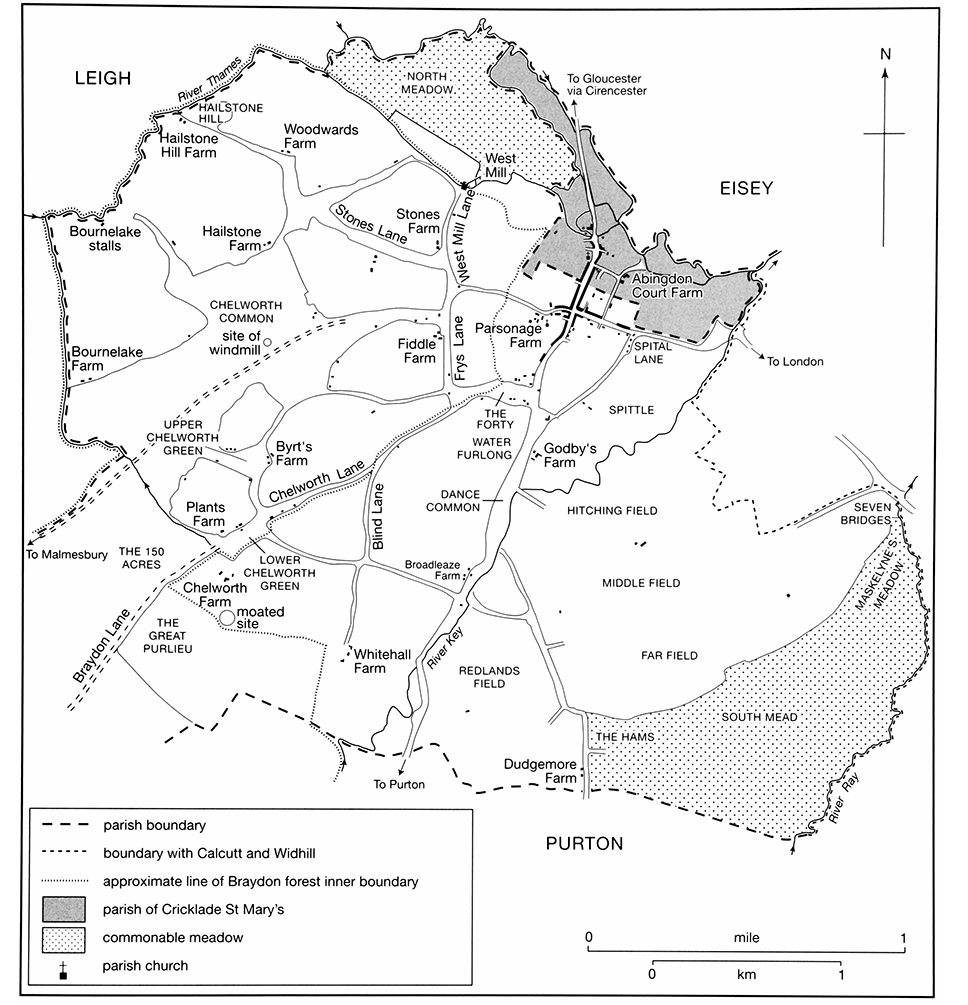
In the Middle Ages three small farming settlements, all in existence before 1086, grew up on the lands beyond the town, at Chelworth to the south-west and to the south-east at Calcutt and further beyond at Widhill. Following the disafforestation of Braydon forest c. 1630, scattered farmsteads were built in the U-shaped part of St Sampson's parish lying south-west of Chelworth.
CHELWORTH
Before 1900
Settlement apparently began where the Thames and the Key meet on closes of land assarted, or taken into cultivation, from the surrounding wastes; it developed mainly in the 18th and 19th centuries to the east of the Purton road on closes allotted under the inclosure awards, and west of the Purton road there were squatter settlements on the edges of the common pasture, small greens, and wide lanes which separated the assarts.
Evidence of c. 1800 suggests that there were c. 16 early assarts, the curved boundaries of some of which may still be visible. (fn. 1) Abingdon Court, the farmstead which was contained within the town's fortifications, was later built on the easternmost assart, bounded by the Thames and the Key; St Sampson's church and Parsonage Farm were both built on what may have been common ground separating it from an assart to its west. The northernmost assart, separated from Gloucestershire by the Thames, took in land called Hailstone and adjoins Hailstone hill. (fn. 2) Other land called Hailstone, on which farmsteads and a chapel stood, probably lay nearby in South Cerney (Glos.). (fn. 3) An almost circular medieval moat and a farmstead lay near the probable boundary between the early assarts and the woodland south-west of them, perhaps denoting the site of Chelworth's manorial complex. (fn. 4)
The early assarts were probably between 10–90 a. and each came to be subdivided into smaller closes; in some cases a second farmstead seems to have been built on them, and in others the farmhouse seems to have gone out of existence. About 1800 there were farmhouses on most of what were probably the early assarts. (fn. 5) Four farmhouses survive, each of which is built of stone, although none are earlier than the 17th century. Abingdon Court Farm has a plain two-storeyed range incorporating a four-light stone-mullioned window; incisions in an ornamental timber lintel of local type suggest that the house was built c. 1630. (fn. 6) Hailstone Farm (the former Woodwards Farm) is of the mid 17th century and is larger and more elaborate than any other house of that period in the parish. It is of two storeys and attics, has a symmetrical flat front from twin gables in which the attics are lit, and has end chimney stacks; two rear wings, one of which was apparently built in the early 18th century, give the house a U plan. The farmhouse at Broadleaze Farm may have at its core an early 18th-century house similar to that at Upper Widhill Farm, and Upper Chelworth Farm is also a small stone farmhouse apparently of the 18th century.
MAP 6. Chelworth and North Meadow, showing the common fields and principal sites in the central part of the parish of St Sampson at the time of inclosure in 1788. The curved boundaries of some holdings are probably the surviving boundaries of the original Anglo-Saxon assarts.
Between 1842 and c. 1900 some 10 small farmhouses were built and others were modernized; as more land was devoted to dairy farming ranges were required for dairies, cheese rooms, and other purposes, and plan forms became more complicated. They were built in a plain rendered style on small farms and were themselves small; while farmhouses they remained small. Most had an L or a T plan and a main façade of two storeys and three bays. Red-brick dressings were used in many of the new buildings, such as the farmhouse at Stones farm, and several of the new farmhouses, such as the four-bayed Pear Tree Farm, were built with a brick chimney stack at each end. At Broadleaze farm, (fn. 7) a wing with a gambrel roof and an extension in diapered brick were added to the farmhouse, and at Dudgemore Farm, where buildings were standing in the later 18th century, (fn. 8) a stone house of three bays and two storeys set end on to the road was apparently refronted and given segment-headed windows in the 1820s or 1830s. At Abingdon Court Farm, where there was apparently an elaborate and extensive farmyard in the 19th century, (fn. 9) a detached twostoreyed cheese room was built in 1821. (fn. 10) The farmhouse at Whitehall Farm, which may have been 17th-century or early 18th, was renovated in the earlier 19th century as a four-bayed and two-storeyed house; a rear range was raised and given external access to an attic, a long two-storeyed service wing with cheese rooms and a dairy was built, and brick buildings, of which a cattle shelter survives, were erected around a farmyard. On the other hand, some farmhouses erected in the earlier 19th century, such as Bournelake Farm and Headlands Farm, were small and on a simple plan.
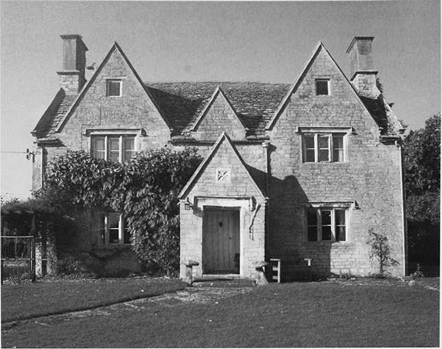
14. Hailstone Farm (the former Woodwards Farm), a mid 17th-century house, the largest and most elaborate farmhouse of that date in Cricklade.
The two largest of the early assarts each contained two groups of buildings c. 1800. Hailstone Farm, near the edge of Chelworth common, and Hailstone Hill Farm, below Hailstone hill, stood on one; Bournelake Farm, near the edge of Chelworth common, and buildings called Bournelake stalls, further north near the Thames, stood on the other. (fn. 11) Hailstone Hill farmhouse had been demolished by 1875, and the remaining buildings were replaced by new ones on Hailstone hill in the 20th century. Hailstone Farm was demolished between 1920 and 1956, and its name was taken over by Woodwards farm. (fn. 12) Towards the south-west Chelworth Farm stood near the site of the moat, perhaps on the site of an early demesne farm; most of the farmstead was demolished in the later 20th century. Upper Broadleaze Farm was built between 1875 and 1898 (fn. 13) on what had earlier been land of Broadleaze farm. (fn. 14)
East of the Purton road the piecemeal inclosure of parts of the open fields in the 17th and 18th centuries was followed by the construction of buildings on some of the new closes. There were buildings at Ballickacre farm, Oxhouse farm, and Farfield Farm by 1788, when the rest of the fields was inclosed, (fn. 15) and at Headlands farm by c. 1800. New farmhouse were built at each of the sites, apparently for the first time, in the 19th century. Farfield Farm, of three bays and two storeys with a brick chimney stack at each end, had been built on land called Bawd House by 1842, (fn. 16) and between 1842 and 1875 houses were built at Oxhouse farm, Ballickacre farm and at Headlands farm; cottages were later attached to the latter. (fn. 17) A new house was built at nearby Ballickacre farm in 1899. (fn. 18)
Dudgemore Farm was built by the late 18th century on pasture inclosed in the 17th century. (fn. 19) Beside the Purton road c. 1800 stood a small group of buildings later called Godby's Farm, the farmhouse of which was rebuilt in the later 19th century. (fn. 20) To the north of this buildings were erected in the earlier 19th century, including the house later called Dance House Farm. Cross Roads Farm was built in the west part of Chelworth between 1842 and 1875, on what had been part of Chelworth common. (fn. 21)
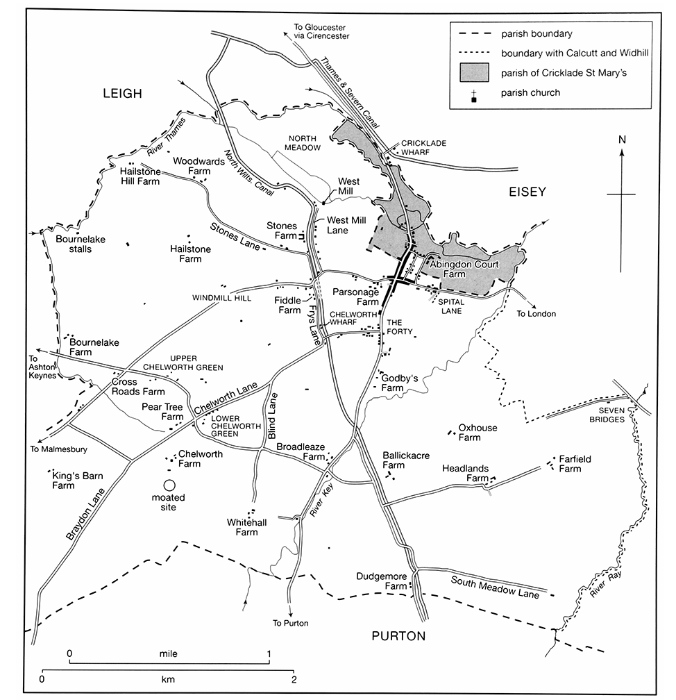
MAP 7. Chelworth and North Meadow c. 1875, showing the principal roads and canals, and expansion of the town, particularly towards the south, perhaps stimulated by the building of Chelworth Wharf.
Squatters had built c. 10 cottages in the west part of Chelworth by 1800, including some near Fiddle farm and some at Lower Chelworth Green, where two 18th century cottages remain today. (fn. 22) At inclosure in 1816–17 the wide lanes were narrowed and parts of the greens and the lanes were allotted as small plots. (fn. 23) New cottages were built beside the lanes and old ones were replaced. In 1842 there were five cottages at Lower Chelworth Green, four at Upper Chelworth Green, and 10 on the south side of the Malmesbury road near Fiddle farm. (fn. 24)
West mill stood on the Thames on Chelworth's land from 1300 or earlier to the 20th century. It was approached from the Malmesbury road to the south by West Mill Lane, a wide lane which continued south of the Malmesbury road as Frys Lane. The North Wilts. canal, opened in 1819, was built along West Mill Lane and Frys Lane (later the Fiddle) and crossed the Malmesbury road in a tunnel. The south part of West Mill Lane was halved, the west half taking the name Hailstone (later Stones) Lane. (fn. 25) In the 19th century several small houses were built on Stones Lane, West Mill Lane and at the south end of Frys Lane, (fn. 26) some of are still standing, as is Tunnel House, a plain classical house of stone with brick dressings which was built at the south end of West Mill Lane c. 1850. (fn. 27) Chelworth wharf, the house and yard of a coal dealer, and a beer shop were built in Fry's Lane, part of which has since been incorporated into a house. (fn. 28)
Twentieth-Century Expansion
New building at Chelworth was more varied than before. Three new early 20th-century farmsteads were built, Bourne Farm off the Purton road by 1921, (fn. 29) Purley Farm off Braydon Lane probably in the 1920s, (fn. 30) and Kingshill Farm off Ermin Street near Seven Bridges c. 1949. (fn. 31) Bourne and Fiddle farmhouses are more ambitious and resemble suburban villas; they are of red brick with stone dressings with, at Fiddle Farm, half-timbering. In the 1920s council houses were built along Malmesbury road and beside Chelworth Road. (fn. 32) About 1922 Common Hill House was built south of Malmesbury Road for G. E. Rice, (fn. 33) in the style of a Cotswold manor house with a long gabled south façade. In 1943 it was bought by Swindon Borough Council, which leased it to Wiltshire County Council in 1948; until 1950 the county council used it as a home for unmarried mothers and from 1951 to 1963 as a home for 25–30 old people; the borough council used it as a convalescent home until 1964 and sold it in 1965. (fn. 34) The house was converted to a hotel and country club in or soon after 1970. (fn. 35) On Hailstone hill, on part of the common pasture inclosed in 1816–17, (fn. 36) a house built in neo-Georgian style in the early 1920s was more than tripled in size c. 1925 for A. Sikes; (fn. 37) a pair of cottages in vernacular style was built near it in 1926. (fn. 38)
In 1942–3 a camp for RAF Blakehill Farm was built on Chelworth's land. Huts set up to accommodate service personnel were used from 1947 to 1956 to house civilians, and a shop, a public hall, and a school were opened. (fn. 39) Nearly all the huts had been removed by 1956. In the 1950s buildings on the airfield were held by civilians for industrial use, (fn. 40) and an industrial estate was erected outside the airfield in the late 1950s, which continues to be enlarged on both sides of Braydon Lane. (fn. 41)
There were c. 20 farmsteads at Chelworth in 1950, and, though there are still buildings on all of the sites, farming has ceased at most of them. In the later 20th century Cricklade spread westwards and embraced Stones Farm, Fiddle Farm, and the site of Parsonage Farm; new houses were built in West Mill Lane, Stones Lane, and the Fiddle. Eastwards the town embraced Abingdon Court Farm. In the same period new houses were built, some apparently in conjunction with small business premises, on individual sites off the Malmesbury road and between it and Chelworth Road and Braydon Lane.
CALCUTT
Calcutt was a small village, to which c. 350 a. of open fields and commonable meadow was assigned. Calcutt village consisted of tenant farmsteads standing along both sides of Ermin Street, which there became a short village street. Calcutt was apparently a planned settlement on Chelworth manor land and had presumably been planted by 1086, when one villanus and four bordars lived there with their families. Later in the Middle Ages and in the 16th and 17th centuries there were probably about eight farmsteads. (fn. 42) In 1377 Calcutt had 23 poll-tax payers. (fn. 43)
About 1801 there were three farmsteads on the northeast side of the road and one or two on the south-west. (fn. 44) The number of buildings on both sides had increased by 1842. On the north-east side Calcutt Hall, of stone and with a three-bayed façade, was built c. 1820, and farm buildings, later called Manor Farm, were erected on an adjoining site. On the south-west side of the road three cottages, a stable, and a barn replaced a building near the south-east end of the village; a farmhouse, farm buildings, and a house which may formerly have been a farmhouse stood north-west of them. (fn. 45)
Two of the farmhouses which were there in 1842 are still standing, Calcutt Farm on the north-east side and Calcutt Court on the south-west side. In the early 19th century the farmhouse at Calcutt Farm was rebuilt as a four-bayed stone house, and a brick barn was built; by 1850 the house had been extended by a north-western wing of stone and brick which was later extended further. At Calcutt Court Farm, which was built in the 18th century, one bay of the three-bayed farmhouse was rebuilt with attic and cellars and a rear wing was added. Of the other two farmhouses on the north-east side one was replaced by Calcutt Manor, a large house of red brick and stone built in the late 19th century. Immediately south-east of Calcutt Farm a pair of cottages was built between 1842 and 1875, (fn. 46) and at Manor Farm a house was built in the later 20th century. On the south-west side of the road part of the house which may formerly have been a farmhouse survives as the rear wing of Ladysmith House, a stonefronted house built presumably in 1900 or soon after. The cottages built in the earlier 19th century were demolished in 1975, when the road was widened and given a second carriageway. (fn. 47)
The area south-east of the village, where Ermin Street crosses the Ray, is called Seven Bridges. In 1829 the road ran for c. 250 ft. on a series of causeways and over four arches, which were repaired in that year. (fn. 48) Near Seven Bridges a commercial garage was built in the mid 20th century on the north-east side of Ermin Street, which was designated a trunk road in 1946. (fn. 49) In the late 20th century the river crossing was widened when a second carriageway was built along the south-west side of the road, and a second commercial garage was built. (fn. 50)
WIDHILL
In the Middle Ages North Widhill and West Widhill were separate, and probably nucleated, settlements. (fn. 51) If their names accurately indicate their position in relation to each other North Widhill was presumably on the site occupied by Lower Widhill Farm, and West Widhill was presumably on a site c. 500 m. to the southwest, which in 1773 was occupied by a farmstead called Widhill Farm. (fn. 52) Each settlement probably consisted of several small farmsteads, and a chapel and a mill were built. The chapel probably stood halfway between them; it was possibly standing in the 13th century and services may have been held in it until the 18th century, (fn. 53) but it was said to be a ruin in 1783. (fn. 54) The mill stood on the Ray in the Middle Ages.
In 1377 nine poll-tax payers were attributed to West Widhill, 36 to an unspecified Widhill; (fn. 55) the second figure seems too high for North Widhill alone. The population of both settlements probably declined in the 15th century, and in the late 16th there may have been no more than one farmstead at Widhill. In 1821 Widhill had 21 inhabitants, the same number it had in 1931, shortly before it was transferred to Blunsdon St Andrew. (fn. 56)
Between c. 1680 and 1707 the whole of Widhill was occupied by the creditors of the owner, John Jenner (d. 1706), and the buildings were neglected. (fn. 57) New farmhouses were probably built at Widhill between 1707 and 1709 and there were apparently three farmsteads there in 1709. (fn. 58) Upper Widhill Farmhouse, which stands on the brow of Blunsdon hill, has an oldfashioned form which may have been influenced by an earlier house on the site; it is one room deep, of two low storeys, and of four bays, and it has plain two-light mullioned windows and end chimney stacks. Lower Widhill Farm was built in a style which was fashionable in the early 18th century; distinguished by a bold mansard roof with dormers, it was built to a compact square plan with four rooms on each of the main floors. A principal house, presumably Widhill Farm, which was rebuilt shortly before 1721, (fn. 59) was demolished in the late 18th century. It was replaced by Chapel Farm, built near the site of the chapel, as a single-pile range with a classical five-bayed façade. (fn. 60) It has a large room on either side of a wide central passage from which a wide staircase with ramped handrail and turned balusters continued to an attic storey.
From the 18th to the early 20th century almost the only dwellings at Widhill were the three farmsteads. Lower Widhill Farm may have been gutted by fire as the floor levels were altered and a new staircase installed, the roof was altered and a cheese room was constructed at attic level; a low extension was built of brick with outbuildings attached. Upper Widhill Farm was extended with a two-storeyed wing with attics, very tall because of the fall of the ground and a stable and two barns were built in the farmyard; the wing was built of stone with brick dressings and the stable and barns of brick. At Chapel Farm large rear wings were added.
A few buildings which stood beside Ermin Street in the 19th century were demolished in the 20th. Between 1921 and 1942 a house and a pair of cottages were built near Lower Widhill Farm, and in the mid 20th century a pair of houses was built beside Ermin Street nearby. On Blunsdon hill a red-brick double-fronted house was built beside Ermin Street c. 1900, and houses and bungalows were built in the 1920s and 1930s in Hillside Road and Widhill Lane. (fn. 61)

MAP 8. The part of the parish of St Sampson within Braydon Forest, c. 1875. Cricklade's parish boundaries with Purton reflect the division of Braydon forest into long narrow hunting rags.
BRAYDON FOREST
The U-shaped part of St Sampson's parish lying southwest of Chelworth remained an uncleared part of Braydon forest. (fn. 62) There were two keepers' lodges, Great (or Old) Lodge to the south-west and Slyfield (later Leighfield) Lodge to the north-east, (fn. 63) presumably among the lodges repaired c. 1611 and c. 1616. (fn. 64) After 1630 the uncleared part of the forest was inclosed and gradually converted to farmland. In 1651 Great Lodge and Slyfield Lodge were each part of a farmstead, (fn. 65) by 1800 about eight other farmsteads had been built in that part of St Sampson's parish, (fn. 66) and by 1900 about another eight farmsteads had been built. (fn. 67)
In 1651 Great Lodge consisted of a hall, a parlour, and other rooms on the ground floor, five bedrooms on the first floor, and four garrets. It then may have been the home of the Nott family, (fn. 68) as it apparently was until c. 1800. (fn. 69) Great Lodge was presumably demolished c. 1850 when a new farmhouse at Ravenshurst, formerly Ravenshouse, Farm was built. This is a large square two-storeyed house, built of smooth-faced pink bricks with flush stone dressings in late-Georgian style; it has a hipped and slated roof and four rooms of roughly equal size flanking an entrance and staircase hall. In 2004 some of the older brick farm buildings, probably slightly older than the house, were ruinous and some, including a coach house and barn, were being converted to domestic accommodation; a 20th-century building was then being converted to resemble a large Georgian stable block. In 1651 Slyfield Lodge was a farmhouse consisting of a hall and other rooms on the ground floor, four rooms on the first floor, and a garret; a brewhouse and bakehouse with two upstairs rooms and two garrets was apparently a separate building. (fn. 70) It was later called Leighfield Lodge Farm and was rebuilt in the 19th and 20th centuries, although 17th-century fabric survived until the 1950s. (fn. 71) A range was built in the earlier 19th century as a three-bayed and two-storeyed farmhouse. The farmyard is large and contains fragments of a large stone barn, a timber-framed building mostly rebuilt in brick, and a formerly thatched animal shed, which may all have been built before the 19th century.
Among the farmsteads built in the 17th or the 18th century Duchy Rag Farm, later Gryphon Lodge Farm, was probably the largest; it was rebuilt c. 1825, (fn. 72) and in the mid 20th century the farmhouse was replaced by a new house. Buildings erected by 1787 in the wide lane of which the south edge marked the south boundary of the parish became those of Gospel Oak Farm; (fn. 73) a farmhouse standing c. 1800 (fn. 74) was rebuilt in 1939. (fn. 75) King's Barn Farm was built after 1788 on land inclosed in that year; (fn. 76) it was demolished c. 1943 to make way for RAF Blakehill Farm. (fn. 77) Four other farmsteads built before c. 1800 have been demolished, including one c. 1840 to make way for the Cheltenham & Great Western Union Railway. (fn. 78)
In the 19th century three new farmsteads were built in the northern arm of the U, five in the southern. In the north Leighfield Cottage Farm and Braydon Cottage had been built by 1842; farm buildings were erected beside Braydon Cottage between 1842 and 1876. (fn. 79) In the 20th century Braydon Cottage was extended and altered and the farmhouse of Leighfield Cottage Farm was replaced by a small house. To the east a small farmstead, Lower Sales Farm, was built, and near it a brickworks was opened, between 1842 and 1875. (fn. 80) A new house was built beside the site of the then disused brickworks in the mid 20th century, and in the late 20th century two new houses were built on the site of the farmstead. (fn. 81) In the southern arm of the U Lower Bury Hill Farm was built c. 1840 to replace the farmstead displaced by the railway, and Lower Farm had also been built by 1842; (fn. 82) only a mid 20thcentury house stood on the site of Lower Bury Hill Farm in 2003. White Lodge was built in 1857, (fn. 83) and by 1876 trees had grown in a small park which was laid out around it and a fishpond had been dug; farm buildings were erected 150 m. east of the house. (fn. 84) In the early 20th century White Lodge was enlarged and improved, (fn. 85) farm buildings erected west of it between 1842 and 1875 and called Lone Barn Farm were also enlarged, and the farm buildings east of White Lodge may have been less used for agriculture; (fn. 86) in the mid and later 20th century houses were built at Lone Barn Farm, the farm buildings there were further enlarged, and the eastern farm buildings were demolished. From c. 1950 White Lodge was a care home for old people. (fn. 87) About 2000 it was again enlarged, and in 2003 it had 41 beds. (fn. 88) In the western corner of the parish Ravensbrook Farm, has a farmhouse with a red brick façade of unusually good quality built between 1842 and 1875; one of the farmsteads built there before c. 1800 was demolished in that period, (fn. 89) and another in the later 20th century. (fn. 90)
In the 20th century four new, small farmsteads were built, each including a farmhouse. South Leigh Farm was built beside the Ashton Keynes to Wootton Bassett road c. 1921, (fn. 91) and Bridge Farm, incorporating a small apparently 19th-century house, was built south of it in the mid 20th century; Derryfield Farm, dilapidated in 2003, was built in the earlier 20th century off the road leading south-east from Minety, and the fourth was built near Ravensbrook Farm in the later 20th century. (fn. 92)
Few other houses were built south-west of Chelworth; three 19th-century cottages were built on the north side of the road west of Cross Roads Farm, (fn. 93) and survived in 2003; two mid 19th-century cottages, (fn. 94) and a mid 20th-century house were built near Duchy Rag Farm, and a pair of mid 20th-century houses was also built near Gospel Oak Farm.
RAF BLAKEHILL FARM
An airfield and RAF station, named after Blakehill farm in Purton, were built by the Air Ministry in 1943. (fn. 95) It covered c. 240 ha., including land in Purton, and was approached from Braydon Lane 500 m. south-west of the crossroads at Lower Chelworth Green. North-east of the airfield, and either side of Braydon Lane, land was designated a technical site, and buildings were erected on it for administration and for storing and maintaining aircraft. Runways were built on the airfield, and an area at the south-west end of the site was set aside for storing bombs. (fn. 96) The RAF station was opened in 1944, and until the end of the Second World War was used mainly by aeroplanes which carried freight, paratroops, and battlefield casualties or towed gliders. A company of Canadian paratroops was among those stationed there. (fn. 97) A camp was built outside the airfield; huts were erected on 11 sites at Chelworth averaging c. 5 a. each. Eight of the sites, including two for women, housed service personnel, and others were used as sick quarters, as a mess, and for entertainment. A transmitting station was built on Windmill hill and a sewage works in Leigh parish. (fn. 98)
RAF Blakehill Farm was closed in 1946. (fn. 99) The airfield was transferred from Transport Command to Flying Training Command and held in reserve. It was little used for flying after 1946 and was a relief landing ground in the 1950s, (fn. 100) when hangars and other buildings beside Braydon Lane were used for civilian industry. From 1963 to 1997 the airfield was the site of a radio receiving station attached to the Government Communications Headquarters, Cheltenham (Glos.). (fn. 101) In 2000 the airfield, excluding the buildings beside Braydon Lane, was bought by Wiltshire Wildlife Trust for preservation as a nature reserve. (fn. 102) In 1946 five of the camp sites and the huts on them were transferred from the Air Ministry to the Ministry of Health and from 1947 to 1956 were used by Cricklade and Wootton Bassett Rural District Council to house civilians. (fn. 103) All 11 sites had been cleared by 1959. (fn. 104)
MANORS AND OTHER ESTATES
In the early Middle Ages the whole of what became Cricklade parish, except Widhill, was probably subject to the lord of Chelworth. Much of the land at Chelworth was apparently assarted early, through individual enterprise not controlled by the lord, and the assarts were therefore held of him as small freeholds. When Cricklade was built as a planned town its tenements were held by burghal tenure; when Calcutt was built as a planned village its land was held by customary tenure. Moreover, from the 13th century the lordship of Chelworth was fragmented among coheirs and the lands of Chelworth and Calcutt lay in the hands of many owners. Besides the part of Braydon forest lying south-west of Chelworth, which was Crown land from 1326 and unimproved before c. 1630, no estate in demesne is known to have exceeded 500 a.; most estates, consisting of single farms or small groups of farms, were much smaller. The lands of Widhill, c. 700 a., apparently lay in small estates in the Middle Ages, united in a single estate from the 16th or 17th to the early 20th century, and afterwards mainly as three separately owned farms.
CHELWORTH
In 688 Baldred (elsewhere described as 'king') (fn. 105) gave 100 manentes of cultivable land beside the river Avon to Aldhelm, abbot of Malmesbury, in exchange for 100 cassati of land on the east side of the wood called Braydon. The exchange may have transferred lordship over Chelworth from Aldhelm to Baldred. (fn. 106) Early settlement at Chelworth was apparently on c. 16 assarts, and the lords of Chelworth may have received rents from the owners of the assarts, and exercised lordship over the lands which they used in common, and Chelworth's woodland. Both Cricklade and Calcutt were apparently planted on these commonable lands: lordship over Cricklade borough and over Calcutt passed to the Crown. Lordship over Calcutt had been separated from lordship over Chelworth by 1086, (fn. 107) and was reunited with it by the 13th century. (fn. 108)
Lordship over Chelworth was devised between 968 and 972 by Aelfheah, ealdorman of Hampshire, to King Edgar. (fn. 109) In 1066 it was held by Edric and in 1084 and 1086 by Warin the bowman, of the king's servants. (fn. 110) It was held by the king in the 12th century (fn. 111) until, as it was later alleged, Henry II, king from 1154, granted it to Odred, his falconer. (fn. 112) In the early 13th century it was held by the serjeanty of keeping Braydon forest. (fn. 113) In 1156 it was held by Jordan de Sandford, (fn. 114) who c. 1174 was succeeded by his son Thomas de Sandford. (fn. 115) Between 1214 and 1218 the lordship passed to Thomas's son Richard de Sandford (fl. 1220), (fn. 116) and it passed in turn to Richard's brothers Warin, who held it in 1221–2, Hugh, who held it probably from 1222, and Thomas, who had entered on it by 1236 and probably by 1231. (fn. 117)
By 1242 Thomas de Sandford had died and his heirs, his nephews Adam of Purton and Hugh Peverell, had partitioned his estate in Chelworth and Calcutt. A claim by his widow Agnes against Adam and Hugh for land in those places as dower succeeded in 1244. (fn. 118) In 1249 what had been Thomas's estate was held by the serjeanty of going with the king's army for 40 days at the feoffee's own expense. (fn. 119) At her death in 1296, Catherine Paynel, daughter and co-heiress of Adam de Purton, d. c. 1266, still held in chief lands and tenements in Chelworth, together with 1/8 part of Staple hundred by serjeanty of finding an armed horseman to serve in the royal army in Wales for five days. (fn. 120) For by then, the lordship over Chelworth was fragmented, and the estates consisted of freehold land or a combination of land and lordship.
Chelworth Cricklade Manor
A rump of what had been Thomas de Sandford's estate came to be called Chelworth Cricklade manor. (fn. 121) Hugh Peverell had alienated 4½ yardlands and 14 a. of his part of the estate by 1250, (fn. 122) and in 1296 what became the manor consisted of 130 a. of demesne land, a pasture worth 5s., woodland, land held by customary tenants, and rent from free tenants. (fn. 123) The woodland was alienated in 1325, and in the early 15th century there may have been less demesne land. (fn. 124) By the early 17th century the customary holdings had apparently been sold, and in 1648 the manor apparently comprised no more than c. 25 a. and £4 1s. 4d. of rent paid by freeholders. (fn. 125)
Hugh Peverell (d. by 1296) gave his estate in Chelworth as dower to his daughter-in-law (fn. 126) Maud Peverell, who died c. 1334 as the widow of Sir William Cotel. (fn. 127) Hugh's heir was his grandson Thomas Peverell (d. by 1300), who left as heirs his sisters Margery, who married Oliver of Dean, Joan, who married John of Wraxall, and Denise, who married Sir John Rivers. (fn. 128) In 1334 the heirs were Margery Dean's daughter Edith, the five daughters of Joan Wraxall, and Denise. (fn. 129) Most of the estate was acquired by Joan's daughter Maud and Maud's husband William Baddeby, to both of whom other heirs or their relatives conveyed land c. 1347. (fn. 130)
On Maud Baddeby's death in 1374 her estate in Chelworth and Calcutt, later called Chelworth Cricklade manor, passed to her daughter Edith Baddeby, the wife of Oliver Cervington. (fn. 131) The manor was held by Oliver at his death in 1419. It passed in turn to his sons Oliver (fn. 132) (d. 1420) and David (fn. 133) (d. 1456), and it descended in the direct line to Edward (fn. 134) (d. 1480–86), Walter (fn. 135) (d. 1510), William (fn. 136) (d. 1521), Nicholas (fn. 137) (d. 1554), and John Cervington. (fn. 138)
Chelworth Cricklade manor was acquired by Thomas Chaffyn, probably by purchase from John Cervington c. 1567. (fn. 139) At Chaffyn's death in 1593 it descended to his infant son Bampfield Chaffyn. (fn. 140) In 1623 Bampfield sold the manor to Edmund Maskelyne (fn. 141) (d. 1630), the lord of Cricklade manor; Maskelyne's son Nevil sold it to Thomas Packer, and in 1648 Packer settled it on his son Robert. In 1648 the manor consisted of little more than the right to receive quit rents, (fn. 142) and its later descent has not been traced.
Little Chelworth Manor
The manor called Little Chelworth from the 17th century (fn. 143) was called Great Chelworth in the 13th. (fn. 144) Although the connection is not always clear, by the later 13th century it appears to have been held with the bailiwick of Braydon forest and was therefore probably an alienated portion of the Sandfords' estate. (fn. 145) In 1621 it comprised 73 a. of demesne land, 164 a. in seven copyholds, feeding rights, and £17 10s. in rents from freeholders; most of the copyhold land lay in Calcutt. (fn. 146)
Three or more of the copyholds were sold in 1654, (fn. 147) and in 1752, when it was sold for £252, the manor apparently consisted of no more than the freeholders' rents and the rights of lordship. (fn. 148) In 1815 the area over which the lordship extended was defined as that, west of Cricklade, which lay within the Inner boundary of Braydon forest, (fn. 149) although in the 17th century the land of the manor lay outside that boundary. (fn. 150)
The manor was held by Robert de Keynes, who in 1243 conveyed the reversion after his own death to Sir Hugh Despenser (d. 1265). (fn. 151) The manor descended to Sir Hugh's son Sir Hugh Despenser (Lord Despenser from 1295, earl of Winchester from 1322), who in 1300 granted it to Robert's namesake Sir Robert de Keynes (d. 1305) for Sir Robert's life. Despenser was disinherited in 1321 for misdeeds as a counsellor of the king, restored to his possessions in 1322, and executed in 1326, when his possessions were again forfeited. (fn. 152) From 1326 to 1377 the manor passed with the Crown. In 1327 it was granted as dower to Queen Isabel (d. 1358), (fn. 153) in 1330 returned by her to the king following her defeat, (fn. 154) and in 1331 restored to her for life. (fn. 155) From 1359 it was held for life by Queen Philippa (d. 1369), (fn. 156) in 1377 Edward III granted it with Vastern manor in Wootton Bassett to his son Edmund, earl of Cambridge (duke of York from 1385, d. 1402), (fn. 157) and from 1391 to 1547 it descended like Cricklade manor. (fn. 158)
In 1547 the reversion of Little Chelworth manor on the death of Catherine Parr (d. 1548) was granted by the king to Edward Seymour, duke of Somerset. (fn. 159) In 1552 Somerset was executed and attainted (fn. 160) and, in November, the king gave the manor to John Dudley, duke of Northumberland, in an exchange. (fn. 161) In January 1553 Northumberland returned it to the king in another exchange, (fn. 162) in July the king granted it to Northumberland's son John, earl of Warwick, and in August it passed back to the Crown when Warwick was attainted. (fn. 163)
In 1555 the Crown granted the manor to Eleanor Kemp, the widow of Sir William Kemp. (fn. 164) In 1571 Eleanor's son Sir Thomas Kemp and other members of the Kemp family sold it to Sir James Croft, comptroller of the Household, (fn. 165) who in 1577 gave it back to the Crown in an exchange. (fn. 166) After 1610 the Crown apparently granted the manor to John Wolstenholme (knighted in 1617), who in 1623–4 conveyed it to Henry Danvers (fn. 167) (earl of Danby from 1626, d. 1644). From Lord Danby it passed to his brother Sir John Danvers (d. 1655), a regicide, who sold parts of it in 1654. (fn. 168) The rest of the manor was among Sir John's estates forfeited at the Restoration and granted in 1661 to trustees of his son Henry Danvers (d. 1654). (fn. 169) The trustees held Little Chelworth manor until in 1673 it was settled with other estates on the marriage of the younger Henry's niece Anne Lee and Thomas Wharton (Baron Wharton from 1696, earl of Wharton from 1706, marquess of Wharton from 1715). On Wharton's death in 1715 the manor passed to his son Philip, marquess of Wharton (duke of Wharton from 1718, d. 1731), whose estates were confiscated when he was outlawed for treason in 1729. In 1733 the estates were settled on trustees for payment of his debts and afterwards for his sisters and coheirs, Jane, the wife of Robert Coke, and Lucy (d. 1739, without issue), the wife of Sir William Morice Bt, and in 1743 were sold on Jane's behalf. (fn. 170)
Little Chelworth manor was bought in 1743 by Sir John Rushout Bt, (fn. 171) who sold it in 1752 to Thomas Bush (fn. 172) (d. 1786), the owner of Great Chelworth manor. Bush devised both manors to John Adams and John's six sisters as tenants in common, in 1793 the devisees or their heirs sold them to Joseph Pitt, (fn. 173) and from 1815 Little Chelworth manor descended like Cricklade manor. (fn. 174)
Great Chelworth Manor
The smallest of the manors or reputed manors of Chelworth was apparently that called Great Chelworth manor from the 16th century. In 1281 it was assessed at 6 yardlands, (fn. 175) in 1533 apparently comprised demesne land, copyholds, and freeholds, (fn. 176) and in 1535 was valued at £8 a year. (fn. 177) In 1672, when the lord tried to enforce attendance at its court, there may have been no copyhold of the manor, (fn. 178) and in the early 18th century the manor apparently comprised no more than c. 61 a. and the manorial rights.
In 1228 the priory of Merton (Surrey) probably held the manor, (fn. 179) which may perhaps have been given to it with the advowson of Somerford Keynes church by Robert de Keynes. (fn. 180) The priory held the manor until 1538, when the priory was dissolved and the manor passed to the Crown. (fn. 181) In 1610 George Salter and John Williams, agents or speculators, bought the manor from the Crown, and in 1611 they conveyed it to Richard George, (fn. 182) whose forbears had been lessees from 1533 or earlier. (fn. 183) On Richard's death in 1613 the manor passed to his brother Robert, (fn. 184) and it descended to Robert's son John, who in 1652 conveyed it to his own son John. In 1677 the younger John George conveyed the manor to his nephew James George (fn. 185) (d. 1684), who devised it to his brother William (d. 1707, without issue). In his lifetime William's title was disputed by his nephew Robert George, and he devised the manor to his wife Rebecca (d. 1722), afterwards the wife of Thomas Powell. (fn. 186)
The Powells gave land in South mead, 11 a. after inclosure, to trustees who were to give half the income to the Blue school in Cirencester and half to poor widows of Cirencester; Rebecca gave other land, 25 a. in North mead and 13 a. at Chelworth, to trustees of the Yellow school, which was founded at Cirencester under her will. (fn. 187) The trustees of those charities owned the lands until 1928 or later, (fn. 188) and afterwards sold them. (fn. 189)
By 1726 the rest of the manor had passed to Robert George, who was succeeded in turn by his son John and grandson Robert George. In 1743 the younger Robert sold it to Rowland Freeman (d. by 1750), who devised it to his daughter Frances Freeman. (fn. 190) In 1751 Frances sold the manorial rights and 12½ a. in South mead to Thomas Bush, (fn. 191) from 1752 Great Chelworth manor descended with Little Chelworth manor, and from 1815 it also descended with Cricklade manor.
Abingdon Court Manor
The estate called Abingdon Court manor from the 15th century, (fn. 192) probably originated as one of the early assarts at Chelworth, and its principal buildings stood within Cricklade's fortifications. When the open fields of Chelworth were set out, part of the land was apparently assigned to this estate, which in the early 16th century included 197 a. of demesne land, with feeding rights in common, also 2 yardlands, a mill, and 4½ burgages held customarily. (fn. 193) In 1850 the estate consisted of 244 a. and c. 20 copyhold houses. (fn. 194)
In the 14th century, and almost certainly in the late 13th, the estate was held with the advowson of St Sampson's church, (fn. 195) and it is therefore likely that John de la Wike (fl. 1204) and Master Richard de la Wike (fl. 1240) held the estate along with the advowson. In the 1270s the estate was probably held by Robert of Abingdon; (fn. 196) by 1294 it had apparently passed to Richard of Abingdon (d. c. 1327), rector of St Sampson's church from 1272 or earlier and a baron of the exchequer from 1299; (fn. 197) in 1329 and 1332 it apparently belonged to another Robert of Abingdon. (fn. 198) The estate passed to one Margaret, whose husband Thomas of St Omer held it by the courtesy after her death. At Thomas's death in 1364 it passed to his and Margaret's daughter Elizabeth, who married in turn Thomas Waryn, Richard Horn (fn. 199) (d. 1394), (fn. 200) and John Syward (d. 1398), (fn. 201) and at Elizabeth's death in 1405 it passed to her daughter Joan Horn, the widow of a younger John Syward and wife of Robert More (fn. 202) (d. 1425). In 1425 the reversion of the estate after the death of Joan was bought by Sir Walter Hungerford (fn. 203) who, under a licence of 1427, granted it to Salisbury cathedral for the maintenance of the Hungerford chantry; the estate apparently passed to the cathedral in 1436. (fn. 204) Like St Sampson's Rectory estate, Abingdon Court manor was held by the cathedral until the dean and chapter surrendered both to the Ecclesiastical Commissioners in 1861, (fn. 205) and, like Parsonage farm, it was given by the commissioners to W. B. Heberden, the owner of the lease, in an exchange in 1894. (fn. 206) Heberden (d. 1922) devised Abingdon Court farm, with the rest of his estate at Cricklade, to his nephew Revd E. B. Heberden (fn. 207) (d. 1954), who in turn devised it to his brother H. W. Heberden (d. 1955), (fn. 208) from whom it passed to his nephew P. H. Rogers (d. 1972, without issue). (fn. 209)
Other Estates
The five estates discussed above were all parts of Thomas de Sandford's estate, which was fragmented in the 13th century. The origins of the other seven are more obscure. Some may have been parts of Sandford's estate or fragments of Chelworth Cricklade, Little Chelworth, or Great Chelworth manors; others, although not clearly identifiable as specific farms, may have been among the early assarts of Chelworth or parts of them.
The extensive woodland which may have passed with the lordship over Chelworth was apparently divided between Adam of Purton and Hugh Peverell, the heirs of Thomas de Sandford (d. by 1242). (fn. 210) Adam's part of it, later called Keynes rag and Poucher's rag, became part of Purton parish. Hugh's part, the Ushaped part of St Sampson's parish south-west of Chelworth, descended with his estate in Chelworth until 1325, when his son-in-law John of Wraxall and two of his granddaughters sold it to Hugh le Despenser, earl of Winchester, the lord of Little Chelworth manor. The woodland passed to the Crown with that manor in 1326 (fn. 211) and, being a large part of Braydon forest as it was defined in 1330, (fn. 212) was retained by the Crown.
Denise Rivers's portion of Hugh Peverell's estate passed at her death in 1347 to her son Sir John Rivers, (fn. 213) who in 1350 conveyed it to Sir Thomas Berkeley, Lord Berkeley (d. 1361), and his wife Catherine (fn. 214) (d. 1386). Catherine settled her estate on William Pucklechurch for his life. The reversion descended to her son Sir John Berkeley (fn. 215) (d. 1428), who apparently held the estate in 1412 and whose heir was his son Sir Maurice (fn. 216) (d. 1460). The estate descended to Sir Maurice's son Sir Maurice (fn. 217) (d. 1474) and apparently to that Sir Maurice's son William Berkeley (d. 1485, without issue). It was held by William's successor, his sister Catherine (d. 1494), who married John Stourton, Lord Stourton (d. 1485), and Sir John Brereton. (fn. 218) Catherine's estate apparently reverted to Sir Edward Berkeley (d. 1506), whose heir was his son John, and a third of it was probably the land said to be at Cricklade allotted to Sir Edward's widow Alice. (fn. 219) Between 1553 and 1557 John Berkeley sold the estate in portions to Thomas Kemble and Sir Anthony Hungerford. (fn. 220)
From his part of Thomas of Sandford's estate Adam of Purton in 1249 granted 2½ yardlands to be held freely. (fn. 221) The rest of his estate at Chelworth was divided c. 1266 among his heirs, his daughter Isabel, the widow of Sir Robert de Welle, who received half, his grandson Robert de Keynes, a minor, who received a quarter, and his daughter Catherine, the wife of Sir John Paynel, who also received a quarter. (fn. 222) In due course some of these portions merged and descended with other landholdings in Cricklade St Sampson and Purton.
Isabel de Welle (d. 1314 or 1315), who married William de Vescy, Lord Vescy (d. 1297), apparently retained her estate in Chelworth in 1281. (fn. 223) Her heir was her grandson Robert, Lord Welles (d. 1320), and, although there is no direct evidence that it did so, her estate may have passed to Robert and descended to Robert's brother Adam, Lord Welles (d. 1345), Adam's son John, Lord Welles (d. 1361), and in turn to John's son John, Lord Welles (d. 1421), and great-grandson Lionel, Lord Welles (d. 1461). (fn. 224) An estate in Chelworth which later belonged to Thomas Lawrence may have been Isabel's and have passed to the Lawrence family by the marriage either of Eleanor, the daughter of Lionel, Lord Welles, and Sir Thomas Lawrence or of Mary, the granddaughter of Lionel's son Richard, Lord Welles (d. 1470), and John Lawrence. (fn. 225)
At his death in or before 1281 Robert de Keynes's portion of Adam of Purton's estate comprised a chief messuage, 65 a. of demesne land, pasture for cattle and pigs, customary holdings, and rents from freeholders. It descended to his son Robert, a minor, (fn. 226) who conveyed it to Sir Hugh Despenser (from 1322 earl of Winchester). The estate was presumably added to Little Chelworth manor. In 1327, when it was held by the Crown, dower in it was granted to Robert's widow Eleanor. (fn. 227)
Catherine Paynel's quarter of Adam of Purton's estate descended at her death in or before 1296 to her son Philip Paynel (fn. 228) (d. by 1299). In 1296 it consisted of little more than 28 a. and the land of two customary tenants. It was assigned as dower to Philip's wife Elizabeth (fn. 229) (fl. 1345), at whose death it was divided between his granddaughters Elizabeth Paynel (d. 1370), who married Richard Gastrick and later Sir Thomas Fulnetby, and Margery Paynel, the wife of John Poucher. Margery was succeeded by her son John Poucher, who was also Elizabeth's heir. (fn. 230) At John's death in 1405 the estate consisted of 37½ a. of demesne land, a share of a common pasture, 4½ yardlands held by customary tenants, and 12s. 1½d. rent from freeholders. It passed in turn to his son (Sir) John Poucher (fn. 231) (d. 1415) and Sir John's son Henry (fn. 232) (d. a minor in 1420) and daughter Joan, a minor in 1420 (fn. 233) and the widow of John Sothill in 1446. (fn. 234) It was conveyed by Joan to Nicholas Wimbish in 1446. Thereafter its descent is uncertain until in 1510, called Chelworth Poucher manor, it belonged to Mary Hungerford, suo jure Baroness Botreaux, Hungerford, and Moleyns, then the wife of Sir Richard Sacheverell. (fn. 235) It passed with Purton Poucher manor in Purton to Mary's kinsman Sir Anthony Hungerford (d. 1558) of Down Ampney (Glos.), who also held Latton and Eisey manors and in the 1550s bought part of what had been Denise Rivers's estate in Chelworth. Sir Anthony's estate in Chelworth apparently descended until the 19th century in the Hungerford, Dunch, Craggs, and Eliot families with Latton manor and, from the earlier 17th century, with Leigh manor. (fn. 236) In 1628 Sir Anthony's great-grandson Sir John Hungerford held six messuages and 70 a. at Chelworth, (fn. 237) and in 1788 Edward Eliot, Lord Eliot (d. 1804), was allotted 18 a. when Chelworth's 150-a. common pasture was inclosed. (fn. 238) In the early 19th century Lord Eliot's estate at Chelworth was apparently small. Part of it was probably sold with Leigh manor in 1803; the rest passed with Latton manor to his son John Eliot (earl of St Germans from 1815, d. 1823), (fn. 239) whose nephew and heir William Eliot, earl of St Germans, owned no land at Chelworth in 1842. (fn. 240)
An estate of 3 yardlands in Chelworth was held by Roger of Writtle in 1275. (fn. 241) In 1285 Roger granted it to Godstow abbey, (fn. 242) which apparently increased it in 1391. (fn. 243) The abbey held the estate until 1539, when the abbey was dissolved and the estate passed to the Crown. (fn. 244) In 1553 the estate was granted to Thomas Cecil and John Bell. (fn. 245) Its descent thereafter is uncertain.
A small estate in Chelworth was acquired by Robert Cricklade in 1393, (fn. 246) and Thomas Cricklade held an estate there in 1412. (fn. 247) About 1458 Thomas's estate was disputed between his younger son John and his grandson and heir John Cricklade, (fn. 248) and it was probably among the lands settled on the grandson in 1466. (fn. 249) The estate was probably among the lands sold by that John Cricklade to his brother-in-law Edward Hungerford in 1468, (fn. 250) and it descended in the Hungerford family of Cadenham (in Bremhill) with the manor of Studley in Calne until the 18th century. (fn. 251) The estate consisted of c. 25 a. at the death of John Hungerford in 1636. (fn. 252) John's grandson Sir George Hungerford (d. 1712) held it in 1709, (fn. 253) but later lords of Studley manor are not known to have held land at Chelworth.
An estate in Chelworth passed from Thomas Warneford (d. 1539) to his son John, (fn. 254) who sold it in portions in 1544. A portion bought by John Goddard (fn. 255) (d. 1560) descended to his son Edward, (fn. 256) who in 1577 held a farm of c. 60 a. in Chelworth. By 1613 he had sold the estate to Edward Maskelyne. (fn. 257) It passed to Edmund Maskelyne (d. 1630) of Purton, lord of Cricklade borough and owner of Chelworth Cricklade manor, and descended to Edmund's son Nevill. (fn. 258) Although the Maskelynes held land in Chelworth in the early 19th century, their holdings cannot be identified with the land bought from Goddard.
An estate including land in Chelworth was bought c. 1560 by Thomas Pleydell (d. 1605 or 1606) of Shrivenham (Berks., later Oxon.), who devised it to his son Edward Pleydell of Cricklade. (fn. 259) At Edward's death in 1633 his estate at Chelworth and Calcutt was assessed at 2 yardlands and 85 a. Most of it descended in the direct line to Edward Pleydell (fn. 260) (d. 1675), Edward, Edward (d. 1731), MP for Cricklade 1698–1700, and Edward (fl. 1765). In 1776 the estate, consisting of West mill and c. 93 a. at Chelworth, houses in Cricklade, and land in North meadow and Calcutt, was sold in portions by trustees of Edward Pleydell. (fn. 261)
The estate of the Wayland's charity included land at Chelworth from 1567, originally part of the endowment of a chantry in Our Lady's chapel, St Sampson's church, which was suppressed by the Crown in 1547. (fn. 262) In 1833, after inclosure, the charity owned 51 a. mainly in Chelworth. (fn. 263) It retained 40 a. in 1959 and sold all its land in 1975–6. (fn. 264)
St John's hospital, Cricklade, held 12 a. in Chelworth in 1281 (fn. 265) and, besides tenements in the town, held c. 22 a. in Chelworth and Calcutt when it was suppressed in 1550. The hospital's estate was bought from the Crown in 1550 by William Fountain and Richard Mayne (fn. 266) and has not been traced further.
Thomas Bush (d. 1786), the lord of Little Chelworth manor from 1752 and of Great Chelworth manor from 1751, and Arnold Nesbitt and Paul Benfield, successive lords of Cricklade manor 1780–91, each accumulated an estate in Chelworth and Calcutt. Bush's estate, c. 133 a. and including the 29-a. Woodward's farm, was sold in portions by his devisees or their heirs in 1793. (fn. 267) Nesbitt's was sold to Benfield, who sold c. 102 a., apparently the whole estate, to Charles Poulton in 1793. (fn. 268)
Freehold Farms
The farms discussed here descended as individual estates for all or part of their history. Most probably originated as early assarts of Chelworth. When open fields and commonable meadows were set out, mainly east of the Purton road, portions were apparently assigned to each farm. In some cases closes to the west and commonable land to the east remained together as one farm; increasingly, however, they were separated and, especially after the commonable lands to the east were inclosed in the 17th and 18th centuries, freehold farms with buildings in the east descended separately. For much of the 20th century the farms were small and often occupied by their owners.
Parsonage Farm
This probably originated as one
of Chelworth's early assarts, to which land in
Chelworth's open fields was added when the fields were
set out; 16th- and 17th-century evidence suggests that
the assart was of c. 33 a. and that 1 yardland of openfield land was added to it. (fn. 269) Parsonage farm was
presumably the land held in the 12th century by
Westminster Abbey with St Sampson's church and the
church's other endowments. (fn. 270) As part of the Rectory
estate the land was held by the rector of St Sampson's
church until its acquisition, probably in the 1430s, by
the dean and chapter of Salisbury cathedral, and by the
Ecclesiastical Commissioners from 1861. (fn. 271) In 1588 the
dean and chapter held roughly 33 a., which had been
divided into four closes, the yardland, 27 a. in South
mead said to be held in place of tithes, feeding for 12
beasts and 1 bull in Dudgemore, a house, and probably a
farmstead. (fn. 272) In 1850 they held the land as Parsonage farm,
80 a., (fn. 273) which in 1894 the Ecclesiastical Commissioners
gave to W. B. Heberden in an exchange. (fn. 274) Parsonage farm
passed with Abingdon Court farm to Revd E. B.
Heberden, H. W. Heberden, and P. H. Rogers in turn. It
afterwards belonged to S. L. Maundrell, who in 1966 sold
the farmstead and c. 5 a. as building land to Cricklade and
Wootton Basett Rural District Council. (fn. 275)
Chelworth Farm
Built on the early Chelworth
assart on which a moat was dug, it apparently belonged
to John Nevill in 1300. (fn. 276) The estate, assessed at 1
carucate, may have been sold by Nevill to Thomas
Shirugge. In 1328 it was disputed between Shirugge and
other members of the Nevill family, and in 1343, when a
third of it was held as dower by John Nevill's widow
Catherine (fl. 1358), was conveyed by Shirugge to Sir
Thomas Seymour (d. 1358). (fn. 277) Sir Thomas conveyed his
estate in Chelworth to Sir John Stock in fee tail with
remainder to Sir John's brother Hugh in fee tail and
reversion to Sir Thomas. (fn. 278) The reversion was acquired
by Sir John Lovel, who in 1382 conveyed the estate, later
called Chelworth farm, to John Urmston (d. 1412) for
40s. a year. Urmston's heir was his brother Thurston,
whose grandson Gilbert Urmston or great-grandson
Gilbert Urmston (d. 1499) (fn. 279) sold the estate in 1469 to
William Nottingham (fn. 280) (knighted in 1480); Nottingham
had apparently held another estate at Chelworth from
1442 or earlier. Sir William (d. 1483) gave his land at
Chelworth with Sapperton manor (Glos.) to trustees for
his wife Elizabeth, and in 1487 Richard Poole, then
Elizabeth's husband, bought it from the trustees. (fn. 281)
Richard Poole (d. 1517) settled Chelworth farm on his son
Henry (fn. 282) (d. by 1536), (fn. 283) and it passed in turn to Henry's sons
Richard (d. 1556) and Edward Poole (fn. 284) (d. 1578). The farm
descended in the direct line to Sir Henry (fn. 285) (d. 1632), Sir
Nevill (fn. 286) (d. c. 1660), Sir Edward (d. 1673), Nevill (fl. 1674),
and possibly Henry Poole. (fn. 287) It was probably sold by either
Nevill or Henry Poole and by 1709 had been acquired by
John Cox. It passed in turn to Cox's son John Hippisley
Cox and grandson Richard Hippisley Cox, who sold it to
John Bristow in 1772. (fn. 288) Bristow (d. 1788) devised the farm
to his sister Sarah Bristow (d. 1793), who devised it to her
nephew William Adams (d. 1812). Adams, who also held
Ballickacre farm, was succeeded by his daughter
Susannah (fn. 289) (d. 1836), who held a total of 348 a. at
Chelworth in 1822 and married William Wells in 1827.
Susannah devised her estate to her husband, (fn. 290) whose
estate passed to W. G. Wells (d. 1887), the owner of other
farms at Chelworth. W. G. Wells's mortgagees sold
Chelworth farm, 166 a., to F. E. Akers in 1918. Akers sold
the farm in portions between 1920 and 1923. The larger
portion, Chelworth farm, 98 a., was bought by T. G.
Clifford; the smaller, 61 a. which became Purley farm,
was bought by Sarah Stump. (fn. 291)
Bournelake Farm
An early assart at Chelworth, later
known by this name, it was apparently among lands which
had belonged to Sir Thomas Seymour, held in 1428, and
possibly in 1412, by Robert Andrew (fn. 292) (d. 1437). Robert's
heir was his nephew John Bourne, whose son John held
the estate at his death in 1477. Like Little Chalfield manor
in Great Chalfield the estate was held for life by the
younger John's widow Margery and her husband William
Walrond with reversion to that John's sister Gillian, the
wife of Edward Cadell. It apparently passed to John Savery,
after whose death it was apparently assigned to his
daughter Anne, who married Thomas Bamfield (fn. 293)
and c. 1544 conveyed her estate in Chelworth to Thomas
Horton (fn. 294) (d. 1549). The estate was held in 1559 by Horton's
widow Margery Horton (d. 1564). (fn. 295) It presumably passed
like an estate in Tilshead in turn to Thomas's son Edward
(d. 1603, without issue) and grandson William Horton, (fn. 296)
who held c. 254 a. in Chelworth. (fn. 297) In 1611 William Horton
sold his estate in portions. One portion, 75 a. bought by
Robert Packer, included 62 a. in closes called Bourne's (fn. 298)
and was probably the land of Bournelake farm. Its descent
from Packer (fl. 1630) (fn. 299) is obscure. By 1691 it had been
acquired by a Dr Adams, and it descended in the Adams
family until the late 1770s. (fn. 300) William Maskelyne (d. 1809)
owned it from 1780 or earlier and it passed to his son
Robert. About 1827 it was apparently sold with Robert's
estate at Leigh to Robert Jenkinson, earl of Liverpool
(d. 1828), Prime Minister 1812–27. (fn. 301) Bournelake farm,
119 a. in 1842, passed in turn to Lord Liverpool's halfbrother Charles Jenkinson, earl of Liverpool (d. 1851), (fn. 302)
Charles's cousin Sir Charles Jenkinson Bt (d. 1855), Sir
Charles's nephew Sir George Jenkinson Bt (d. 1892), and
Sir George's son Sir George Jenkinson Bt (d. 1915), who
owned it in 1914. (fn. 303) By 1928 it had been acquired by J. C.
Hicks, probably by purchase from the younger Sir
George's grandson Sir Anthony Jenkinson Bt, (fn. 304) and it
descended in the Hicks family until the later 20th
century. (fn. 305) From 1981 to 1991 it belonged to M. C. Lewis. (fn. 306)
A holding sold in 1572 by Richard Prater to Thomas
Messenger (fn. 307) was possibly the 22 a., assessed at 1 yardland,
at Bournelake held by William Messenger 1628–30. (fn. 308)
Later it was part of Bournelake farm. (fn. 309)
Byrts'
Another portion of land sold by William
Horton in 1611, it included closes called Ingrams and
Deeps, both subdivisions of two early assarts near
Upper Chelworth Green, which were bought by
Edward Vaughan of Buttas (Herefs.). (fn. 310) By 1628 a 77-a.
holding, including those closes and land in the open
fields and commonable meadows of Chelworth, had been
sold by Vaughan to Richard Byrt. (fn. 311) The land descended
in the Byrt family and belonged to a succession of
Richard Byrts. (fn. 312) In the 1780s John Byrt (d. 1796) and his
nephew Morgan Byrt each held an estate at Chelworth.
About half of John's passed at his death to Morgan, (fn. 313) who
held c. 134 a. at his death in 1823. Morgan devised his land
to his daughter Mary (d. 1834), the wife of Robert Jordan,
and it descended to her son James Byrt Jordan (d. 1864). (fn. 314)
In 1865 the land was offered for sale and was probably
sold in portions. (fn. 315) Between 1910 and 1914 Wiltshire
County Council bought 50 a. at Upper Chelworth Green
formerly part of the Byrts' estate, including Ingrams and
Deeps; (fn. 316) the land was known as Cowleaze farm and was
sold by the council c. 2000. (fn. 317)
Woodward's (later Hailstone) Farm
This was apparently
an early assart of c. 30 a. (fn. 318) In 1611 the land lay as four
closes called the Hailstone grounds and was part of the
estate sold by William Horton to Edward Vaughan.
Christopher Kennet alias Saunders, the joint tenant
then, (fn. 319) may have been the Christopher Saunders who
owned that land in 1630. (fn. 320) Woodward's farm was later
acquired by Thomas Bush (d. 1786), the lord of Great
and Little Chelworth manors and, 29 a., was offered for
sale in 1793 by his devisees or their heirs. (fn. 321) It was
apparently bought c. 1797 by Thomas Hinton (d. 1814)
and passed to his widow Mary Hinton, the owner until
c. 1837. From c. 1837 George Newmarch owned the
farm (fn. 322) which, part of a holding of 130 a., was offered for
sale in 1842 and 1844. (fn. 323) Later owners included members
of the Bullock family in the later 19th century and early
20th. (fn. 324) In 1919 the farm, 90 a., was bought by W. F.
Fuller, the master of the Cricklade division of the Vale
of the White Horse hunt, which had kennels nearby. (fn. 325) It
was apparently renamed Hailstone Farm after an earlier
farm of that name was demolished. (fn. 326)
Hailstone Hill Farm
This may earlier have been the
estate of Isabel de Welle at Chelworth, which
apparently belonged to Thomas Lawrence in 1621 and
1630, when it probably included that part of one of
Chelworth's early assarts later called Hailstone Hill
farm. (fn. 327) Thomas bought other land in 1657. His estate
seems to have descended in the direct line to his son
John, grandson Robert, and great-grandson Littleton
Lawrence of Painswick (Glos.), (fn. 328) who until 1738 held
perhaps c. 250 a. at Chelworth. The larger part of that
estate passed from Littleton to Robert Lawrence and to
William Lawrence, who in 1788 sold that part to
Richard Kinneir (fn. 329) (d. 1813). Hailstone Hill farm, 73 a. in
1842, descended to Richard's son Richard, (fn. 330) who in 1863
conveyed it to his own son Richard. In 1867 that latter
Richard Kinneir sold the farm to Edward Eliot, earl of
St Germans. (fn. 331) It passed with the St Germans title as part
of the Down Ampney estate and by 1910 had been
merged with Stones farm. (fn. 332)
Broadleaze Farm
Originally an 86-a. pasture called
Broad leaze, it was apparently one of the early assarts of
Chelworth, which was sold in 1575 by Edward Poole to
Giles Poole (fn. 333) (d. 1589). It descended in the direct line to
Sir Henry Poole (d. 1616) and Henry Poole, who in 1627
sold it to William Sadler. (fn. 334) As Broadleaze farm, it
belonged in the late 17th century or early 18th to
another William Sadler; it passed to his daughters Anne
Tooker and Joanna Madocks, and in 1709–10 it was
partitioned between Joanna and Anne's son Charles
Tooker. The farmhouse and 40 a. were allotted to
Joanna, descended to her daughter Anne Saunders and
possibly to Anne's son John Saunders, and passed to
Anne's daughter Jane Saunders, the wife of Sir William
Guise Bt; Charles Tooker (d. 1716) apparently alienated
his land. (fn. 335) In 1772 Sir William Guise sold Broadleaze
farm to Charles Poulton, (fn. 336) who in 1793 bought 46 a.
from the devisees of Thomas Bush and c. 102 a. from
Paul Benfield. (fn. 337) Poulton (d. 1805) settled part of his estate
on his daughter Mary Wells; he devised the rest to his
wife Anne Poulton (d. 1818) for life and to their sons
William, Joseph, and Charles and their daughter Anne,
the wife of Revd William Wavell. (fn. 338) Anne held 261 a. at
Chelworth in 1811. (fn. 339) Broadleaze farm, 72 a. in 1842, may
have been assigned to William, who was declared
bankrupt in 1832, and was held by Charles, possibly as a
trustee, in 1842. The lands held by the other siblings were
not discrete farms, (fn. 340) and their descent has not been traced.
Broadleaze farm was held by William Poulton in 1848–9
and by his nephew C. W. Poulton from c. 1851 (fn. 341) and in 1857,
when it was of 77 a. (fn. 342) The farm was afterwards bought by
William Wells or W. G. Wells and passed with Chelworth
farm to W. G. Wells's mortgagees. Between 1910 and 1914
the mortgagees sold it to Charles Kinnett (d. 1920), the
owner of Oxhouse farm. (fn. 343) Broadleaze farm passed to
Kinnett's widow Agnes, whose executors sold it to R. H.
Cole in 1928. (fn. 344)
Butlers
One of Chelworth's early assarts, it was
apparently divided into closes called Butlers and
Doubledays. Butlers, on which a farmstead may have
stood near the site of Chelworth wharf, (fn. 345) was apparently
the nucleus of an estate at Chelworth which belonged to
Thomas Dennis (fl. 1567). The estate descended to
Thomas's son Richard, whose title was disputed in
1613–14 by his brother Henry. (fn. 346) The estate apparently
passed to Henry, (fn. 347) and then in the direct line to another
Richard (d. c. 1671), Henry (fl. 1726), and Henry Dennis,
and was added to by purchase. (fn. 348) In 1753 that last Henry's
daughters and heirs Anne and Mary Dennis sold 112 a.,
most or all of the estate, in six portions. (fn. 349)
Doubledays
A 55-a. estate including the close
called Doubledays, it was apparently a division of one
of Chelworth's early assarts, which passed on the
death of Francis Walrond in 1613 to his brother
Richard (d. 1640), whose heir was his son Edward. (fn. 350)
Doubledays later belonged to Richard Painter; in 1750
it belonged to Joseph Cox (fn. 351) of Stanford-in-the-Vale
(Berks., later Oxon.), who by will proved 1753 gave it
to his son Thomas. (fn. 352)
Plants Farm
In 1544 Thomas Trinder bought a
portion of the estate sold by John Warneford, (fn. 353) and in
1552 he bought c. 25 a. at Chelworth from Sir Anthony
Hungerford. (fn. 354) A holding called Plants, with a farmstead
on an early assart at Lower Chelworth Green,
descended in the Trinder family from 1607 or earlier. (fn. 355)
In 1693 it consisted of the farmstead, 37 a., and feeding
rights; (fn. 356) after inclosure it measured 48 a. (fn. 357) In 1780 the
farm was assigned to Silvester Trinder (will proved
1785), a widow, who devised it to her daughters Silvester
and Eleanor Trinder as tenants in common. (fn. 358) Silvester,
and Eleanor and her husband William Talmage, held it
in 1788 and apparently 1824, Eleanor and William alone
in 1830. (fn. 359) Plants farm, 52 a., belonged to William
Talmage in 1842 and 1857 (fn. 360) and to W. T. Talmage and
Mary Lyne in 1872. (fn. 361) The farmstead and some of the
land later descended in the Heaven family. (fn. 362)
Hailstone Farm
Apparently the south part of an early
assart, (fn. 363) it belonged c. 1800 to William Maskelyne, (fn. 364) and
in 1816–17 was increased by allotments at inclosure from
c. 45 a. to c. 80 a. (fn. 365) Maskelyne (d. 1840) was succeeded by
his son the Revd William Maskelyne, (fn. 366) who apparently
sold the farm to Edward Eliot, earl of St Germans, c.
1864. (fn. 367) The farm was later added to Stones farm, and the
name applied to Woodwards Farm. (fn. 368)
Stones Farm
Apparently an early assart, (fn. 369) it was
probably held by Richard Goddard at his death between
1615 and 1619, (fn. 370) was held by Alice Organ in 1630, (fn. 371) and
was possibly held by members of the Hippisley family
in the 1690s. (fn. 372) In 1789 it belonged to Thomas Jenner,
and it belonged to Jenner or a namesake until the
1850s. (fn. 373) Stones farm belonged to Misses Cripps in 1857 (fn. 374)
and, apparently by purchase c. 1860, was acquired by
Edward Eliot, earl of St Germans. (fn. 375) The land of other
farms was added to Stones farm, which passed with
Latton manor and the St Germans title and was of 244
a. in 1910. (fn. 376) Between 1910 and 1914 Stones farm was
apparently sold by John Eliot, earl of St Germans, to R.
J. Large, who sold it in 1919 to Clement Cowley. (fn. 377)
Whitehall Farm
The land which became Whitehall
farm may, like that which became Chelworth farm,
have belonged to John Nevill in 1300. (fn. 378) Unless, however,
it descended with Chelworth farm, its descent is
obscure until the 18th century. From 1780 or earlier
Whitehall farm belonged to Robert Darell (fn. 379) (d. 1801),
who devised it to his brother Edward (fn. 380) (d. 1814). Edward
devised it to his nephew Revd John Jeffreys (fn. 381) (d. 1840),
after whose death his trustees held the farm, 107 a. in
1842. (fn. 382) In 1866 the trustees sold the farm to W. J. Large (fn. 383)
(d. 1914), whose executors held it in 1920. (fn. 384) In 1928 the
farm belonged to G. W. Freeth, (fn. 385) and since the 1940s it
has belonged to members of the Sweet family (fn. 386)
Fiddle Farm
Probably an early assart of Chelworth, (fn. 387)
the farm, 34 a., belonged to Joseph Pitt (d. 1842), the lord
of Cricklade and Great and Little Chelworth manors,
and in 1842, by order of Chancery, was sold on behalf of
his creditors. (fn. 388) The buyer was George Akerman (fn. 389) (d. 1877),
whose trustees offered Fiddle farm for sale in 1883. (fn. 390) The
buyer then was probably Revd William Heberden,
whose son W. B. Heberden was the owner in 1901, and
the farm descended in the Heberden family with
Abingdon Court, Parsonage, and Headlands farms. (fn. 391) Its
descent from 1955 has not been traced.
Dudgemore Farm
This was built apparently in the
late 18th century on what until the 17th century had been
a common pasture. In the earlier 19th century the
farmstead and the land around it was bought from
Thomas Still by William Large (d. c. 1850), who owned
Dudgemore farm, 36 a., in 1842. (fn. 392) The farm was held by
Large's executors until 1920, (fn. 393) when it was bought by
Thomas Messenger (d. 1938). Although in 1938, after
Messenger's death, it was offered for sale, (fn. 394) the farm later
belonged to another Thomas Messenger. (fn. 395)
Ballickacre Farm
An estate at Chelworth descended
from Thomas Russhley to his son Thomas (d. c. 1550)
and to Thomas's son William; in the 1550s and 1560s
William's title to it was challenged, apparently
unsuccessfully, by his cousin John Russhley and by
Joan Russhley. (fn. 396) William held c. 100 a. at Chelworth in
1583. (fn. 397) His estate passed to Anne Russhley, the wife of
Mark Cottle (will proved 1627), and, c. 105 a., was sold by
Mark's son Richard Cottle of North Tawton (Devon) to
Thomas Lawrence in 1657; (fn. 398) it descended with Hailstone
Hill farm to Littleton Lawrence. Ballickacre farm
apparently originated in the sale of much of what had
been the Cottles' land by Littleton Lawrence to
Robert Bristow in 1738. Bristow (d. 1769) divided his
land among his son John (d. 1788), who bought
Chelworth farm, and his daughters Sarah (d. unmarried
1793) and Susannah Adams, whose son William
Adams (d. 1812) inherited all of it. (fn. 399) Ballickacre farm,
132 a. in 1842, (fn. 400) descended with Chelworth farm until,
between 1914 and 1920, the mortgagees of W. G. Wells
sold it to John Giles. (fn. 401) The farm was again offered for
sale in 1942. (fn. 402)
Farfield Farm
This may have originated in the sale
of 29 a. by Littleton Lawrence to Joseph Hall in 1738. Hall
settled the land on the marriage of his son William (will
proved 1779), whose widow Edith Hall sold it to Richard
Kinneir in 1787. (fn. 403) Farfield farm, 71 a. in 1842, (fn. 404) descended
with Hailstone Hill farm from 1788 to 1858, when the third
Richard Kinneir sold it to Thomas Tucker (fn. 405) (d. 1868).
Tucker devised it to his wife's nephew Henry Cook
(d. 1874), who devised it to his wife Lydia. The farm was
sold in 1877 by Lydia Cook to William Wells or W. G.
Wells, (fn. 406) and it thereafter descended with Chelworth farm
until, between 1914 and 1920, the mortgagees of W. G.
Wells sold it to E. St J. Richardson. (fn. 407) It belonged to P.
Richardson in the mid 20th century. (fn. 408)
Oxhouse Farm
In 1753 Jonathon White bought 57 a.
of the land sold by Anne and Mary Dennis. (fn. 409) Buildings
erected on land inclosed piecemeal from Chelworth's
open fields, and 61 a. allotted to White to replace the 57 a.
and other land when South mead and the open fields
were inclosed in 1788, became Oxhouse farm. (fn. 410) The
farm, 66 a. in 1842, (fn. 411) passed from White (d. 1791) to his
son Robert (d. c. 1824), and it descended to Robert's son
John White, who apparently owned it until the 1880s or
later. (fn. 412) In 1910 the farm belonged to Charles Kinnett, (fn. 413)
afterwards the owner of Broadleaze farm. Between 1920
and 1928 it was apparently bought by R. C. Millard. (fn. 414)
Headlands Farm
Members of the Heberden family,
lessees of the Rectory estate, including Parsonage farm,
and of Abingdon Court manor, (fn. 415) accumulated a freehold
estate at Chelworth. William Heberden (d. 1801), lessee
from 1754, was allotted 33 a. at inclosure in 1788, (fn. 416) and his
son, the Revd Thomas Heberden (d. 1843), held 103 a. at
Chelworth and Calcutt in 1842. (fn. 417) Thomas was succeeded in
turn by his sons Thomas (d. 1877) and Revd William
Heberden (d. 1890), (fn. 418) whose heir was his son W. B.
Heberden. In the 20th century the land held freely by the
Heberdens before 1894, when W. B. Heberden acquired
the freehold of Parsonage and Abingdon Court farms,
was represented by Headlands farm, 154 a. in 1910. (fn. 419)
Headlands farm passed with Abingdon Court farm to
Revd E. B. Heberden, H. W. Heberden, and P. H. Rogers
in turn. (fn. 420) Its descent from 1955 has not been traced.
CALCUTT
Lordship over Calcutt, a village apparently planted on Chelworth's land, was separate from lordship over Chelworth in 1084. In that year and in 1086 Calcutt was held by Odo of Winchester, a thegn of the king. (fn. 421) Later the lordship over Calcutt was probably acquired by one of the Sandfords and, presumably again, was held with that over Chelworth; rent from Calcutt's land belonged to Thomas de Sandford (d. by 1242). (fn. 422)
In the Middle Ages Calcutt almost certainly consisted of small farmsteads held customarily and, as the lordship over Chelworth was fragmented, holdings there were apparently attached to and descended with various estates in Chelworth. Little Chelworth manor, probably alienated by the earlier 13th century, is known to have included land in Calcutt in the 14th century, (fn. 423) and in 1621 it included 130 a. of Calcutt's land in five copyholds apparently with farmsteads at Calcutt; (fn. 424) in 1654 Sir John Danvers, the lord of Little Chelworth manor, completed separate sales of three theretofore copyhold farms with a total of 99 a. there. (fn. 425) The other holdings in Calcutt were apparently shared between Thomas de Sandford's heirs Adam of Purton and Hugh Peverell when his estate was partitioned. Adam's share, like his part of that estate, was divided among his heirs c. 1266; Hugh's, like his part of the estate, was divided c. 1335 among the heirs of his grandson Thomas Peverell. Of Adam's successors Gillian Cadell held land at Calcutt in 1481 (fn. 426) and Philip Paynell (d. 1299), and members of the Poucher family as his successors, owned a holding there. (fn. 427) Of Hugh's successors Denise Rivers and her successors, and Maud Baddesby and hers as lords of Chelworth Cricklade manor, owned land at Calcutt. (fn. 428) From the late 14th century or earlier Abingdon Court manor included land at Calcutt, (fn. 429) and in the 16th century land there was held with several estates at Chelworth including those of John Goddard (d. 1560) (fn. 430) and Thomas Pleydell (d. 1605 or 1606). (fn. 431)
From the mid 17th century most of Calcutt's land apparently lay in small freehold farms based at Calcutt. There may then have been about eight farms; in 1842 there were four. An exception was the land of Abingdon Court manor which, c. 46 a., remained part of the manor in the 19th century (fn. 432) and of the estate of the Heberden family in the 20th. (fn. 433) There was a farmstead on the land in the 16th century, (fn. 434) not in the 19th. (fn. 435)
Freehold Farms
Calcutt Farm
This was probably once part of the
freehold lands held by Daniel Champernowne alias
Slatter (d. 1612). Daniel's land passed at his death to his
son Moses (fn. 436) and descended in the Champernowne alias
Slatter family. It passed to William Champernowne alias
Slatter (fl. 1669) and to his son Richard (d. by 1708), who,
by his marriage to Mary, the daughter and heir of
William Burge, apparently acquired the farm sold by Sir
John Danvers to Burge in 1654. Richard's heir was his son
William Champernowne alias Slatter (d. 1752), and
although in 1718 William sold or mortgaged part of the
estate to his brother Richard, a maltster, the whole estate
was apparently held in turn by his son Richard and that
Richard's son William Champernowne alias Slatter
(d. 1818). In 1797 William bought 21 a. or a little more
from Joseph Pitt. (fn. 437) His whole estate was divided between
his sons Richard and William, who in 1824 each held c. 70
a. In 1831 William and his three sisters bought Richard's
land, and in 1833 William conveyed his interest in that,
and his own land, to his sisters. (fn. 438) About 1842 Calcutt farm,
130 a., was acquired by the trustees of Thomas Packer
Butt (fn. 439) (d. 1828); it was presumably bought from the
sisters, to whom Butt's successors were related by
marriage, and it passed to Butt's son W. P. C. Butt (d. 1848).
The younger Butt devised the farm to his sister Lydia
Butt (fn. 440) (d. unmarried 1875), whose heir was her sister Ann,
the widow of Revd James Fisher and from 1879 the wife
of J. H. Sadler. Ann (d. 1884) devised Calcutt farm with
Shaw farm in Lydiard Millicent to her son J. E. O. Fisher
and her daughters Annie Fisher and Alice Fisher. Alice
(d. 1884) devised her interest to her siblings, who in 1885
partitioned their mother's estate. Calcutt farm was
conveyed to Sadler in trust for Annie Fisher, and Sadler
held it, presumably as a trustee, until his death in 1929. In
1930 executors or trustees sold the farm, then 193 a., to
Frederick Freeth. (fn. 441) About 1949 Freeth sold the farmstead
and his land north-east of the London–Gloucester road
and retained his land south-west of the road as Kingshill
farm. In 2003 Kingshill farm belonged to his son Mr R.
Freeth. (fn. 442) In 1976 M. C. Lewis bought 140 a. of what had
been Calcutt farm north-east of the road and added it to
Manor farm, Water Eaton, as part of which it belonged
to Mr D. C. Lewis in 2003. (fn. 443)
Calcutt Court Farm
Land in Calcutt was devised
by Henry Kemble (d. c. 1580) to Thomas Dennis (fn. 444) and
was presumably the land there held in 1654 by Henry
Dennis. (fn. 445) Henry's land descended in the Dennis family
with land in Chelworth, and in 1753 Anne and Mary
Dennis sold 13½ a. to Charles Harris (fn. 446) and in 1754 a 29-a.
farm to John Self (d. by 1770). In 1770 Self's son John
sold the farm to John Creed, who bought other land in
1782. Creed's estate passed to his son John, who in 1797
bought land from Joseph Pitt, (fn. 447) and in 1811 held a 53-a.
farm at Calcutt. (fn. 448) Possibly by inheritance or devise the
farm passed c. 1817 from John Creed to Elizabeth
Adams, a widow, and c. 1820 from Elizabeth to John
Gingell. (fn. 449) In 1836 it was sold by Gingell and his sisters
Elizabeth and Mary Gingell to George Akerman (fn. 450) (d. 1877), (fn. 451)
who owned the farm, 70 a., in 1842. (fn. 452) The farm, later
called Calcutt Court farm, passed with Fiddle farm at
Chelworth to Akerman's trustees, who in 1883 sold it as
a 31-a. farm to N. B. Langley (d. 1909). (fn. 453) In 1919
Langley's widow Adela Langley sold the farm, then c. 60
a., to Victor Cuss, (fn. 454) who held it in the mid 1930s. It later
belonged to members of the Kinch family. (fn. 455)
Cullerne's Farm
In 1811 two small farms at Calcutt
belonged to Henry Cullerne (fn. 456) (d. 1818). (fn. 457) One, of 47 a.,
was probably the land at Calcutt devised by Thomas
Cullerne (d. 1722) of Eastrop in Highworth to his cousin
James Cullerne of Sutton (Berks.). (fn. 458) The other, of 37 a.,
was sold by the younger John Self to Edward Wilbraham
in 1770 (fn. 459) and by Wilbraham to Henry Cullerne in 1807. (fn. 460)
Henry devised his estate in trust for sale. (fn. 461) By c. 1825 it had
been acquired by Edmund Ruck, and it belonged to
Joseph Ruck from c. 1826 to c. 1840. The estate was
bought by Thomas Strong, (fn. 462) who held it as a 61-a. farm
in 1842. (fn. 463) Part of the farm was sold in 1865 to Edward
Eliot, earl of St Germans, and, with Russhey mead in
Calcutt, was sold c. 1918 by John Eliot, earl of St Germans.
The rest was acquired in the late 19th century by N. B.
Langley and added to Calcutt Court farm. (fn. 464)
Fletcher's Farm
An estate in Calcutt including two
farmsteads, it was in 1733 settled by David Moulder on
the marriage of his son Richard (d. 1741–2). Although at
his death Richard had three sons and a brother, by 1763
the estate had passed to his sister Mary Humphries, who
devised it in turn to trustees to pay debts and legacies, to
Richard Howse for life, and to David Moulder Bryan. (fn. 465)
In 1772 David held 66 a. and the two farmsteads. (fn. 466) In
1797 he sold the estate to Joseph Pitt, (fn. 467) who himself sold
land in Calcutt in that year and in 1803. (fn. 468) A farmhouse
and 22 a., part of Bryan's estate in 1772 and acquired by
Edmund Fletcher, was apparently bought from Pitt in
1803. (fn. 469) Fletcher's farm, including a house on the site later
occupied by Calcutt Manor, passed from Fletcher (d. 1826)
to Margaret Fletcher (d. 1833) and in turn to a Mr Jacobs
and, c. 1839, to Elizabeth Pinneger. The estate, still no
more than a house and 22 a., belonged to Charles
Pinneger in the later 19th century and to Sarah Heaven
in the early 20th. (fn. 470)
Russhey Mead
A farm of 36 a. in 1824, (fn. 471) it belonged
to Cirencester abbey in 1275. (fn. 472) Despite challenges to its
title to all or some of the meadow by the king in 1281 (fn. 473)
and by the burgesses of Cricklade in 1343, (fn. 474) the abbey
kept it until the Dissolution. (fn. 475) With the manors of
Latton and Eisey the meadow, on which men of
Calcutt had the right to feed animals in common,
passed to the Crown in 1539. Two estates, each said to
include the first cut of all or part of Russhey mead and
of meadow land in Latton and Eisey, were granted by
the Crown; (fn. 476) their descent has not been traced in
detail. In the 19th century Russhey mead, like Latton
and Eisey manors, descended in the Eliot family with
the title earl of St Germans, and c. 1918 it was sold by
John Eliot, earl of St Germans. (fn. 477) In 1971 it was part of
60 a. in Calcutt bought by M. C. Lewis and added to
Manor farm, Water Eaton, and in 2003 it belonged to
Mr D. C. Lewis. (fn. 478)
WIDHILL
In the Middle Ages the principal estates were apparently West Widhill and North Widhill and there is evidence of small freeholds, dating especially from the 13th century. (fn. 479)
West Widhill
An estate held by Alfred of Marlborough in 1086 was almost certainly that later called West Widhill. Gunfrid, probably Gunfrid Mauduit, held it of Alfred. (fn. 480)
The overlordship of West Widhill descended in the Ewias and Tregoze families in the same way as Lydiard Tregoze manor. (fn. 481) Robert Tregoze (d. 1265) was overlord in 1242–3 and his son John Tregoze was overlord at his death in 1300. (fn. 482) At the partition of John's estates in 1300 West Widhill was apparently assigned to his grandson John la Warre (Lord la Warre from 1307, d. 1347), whose grandson Roger la Warre, Lord la Warre, was considered to have been overlord at his death in 1370. (fn. 483)
By 1243 the lordship in demesne of West Widhill had been divided. Part had apparently descended in the Mauduit family to Thomas Mauduit, who held ¼ knight's fee at West Widhill in 1242–3, (fn. 484) and it passed to William Mauduit, who was hanged for felony in or before 1273. (fn. 485) William's estate was acquired by John Gay, who held it in the late 1270s, (fn. 486) and by 1300 it had passed to Philip Gay, (fn. 487) who apparently sold it to Adam of Bromesdon in 1305. Also in 1305 Adam conveyed 50 a. in West Widhill and Blunsdon Gay to John Lovel, Lord Lovel. (fn. 488) The estate retained by Adam was probably that in West Widhill and Blunsdon Gay held by John of Groundwell and afterwards by James of Groundwell, a bastard, who died without issue in 1342. After his death in 1310 Lord Lovel's estate, which may have been held with Blunsdon Gay manor, was held for life by his widow Joan (d. 1348). On Joan's death it passed to Lord Lovel's great-grandson John Lovel, Lord Lovel (d. 1361, without issue), a minor and a ward of the king, and on that John's death it passed to his brother John Lovel, Lord Lovel (d. 1408), a minor until 1363. James of Groundwell's estate was claimed as an escheat by Sir Roger Bavant, who was the lord of land at West Widhill and whose estates were held from 1344 by the king, and by John, Lord Lovel (d. 1347), who entered on the land and whose son John, Lord Lovel, was defending his right to it in 1370. (fn. 489) The later descent of both Groundwell's and Lord Lovel's estates is obscure.
The other part of the lordship in demesne of West Widhill passed to Godfrey Scudamore, who in 1242–3 held ¼ knight's fee there of Robert Tregoze. (fn. 490) Godfrey's estate presumably descended like Upton Scudamore manor to Peter Scudamore (d. c. 1293) and like Fifield Bavant manor to Peter's daughter Alice (d. by 1301), the widow of Adam Bavant, to Alice's son Sir Roger Bavant (d. by 1338), and to Sir Roger's son Sir Roger. (fn. 491) In 1344 Sir Roger held a mill and 11 a. at West Widhill and claimed rents from freeholders and rights as an overlord there. (fn. 492) In that year he granted that estate with Fifield Bavant manor to the king, and it passed with the manor to Dartford priory (Kent). (fn. 493) The priory is not known to have held land at Widhill at the Dissolution. (fn. 494)
North Widhill
An estate at North Widhill was held in 1066 by Robert son of Wimarc, Robert having been a staller at the court of Edward the Confessor, and in 1084 and 1086 it was held by Tetbald the physician and Humphrey the cook, two of the king's servants. (fn. 495)
What had presumably been Humphrey's part of the estate was held in 1198 by Geoffrey son of Pain by the serjeanty of a cook, (fn. 496) and c. 1211 Geoffrey's son John held it for service as an usher of the king's kitchen. (fn. 497) About 1227 Aubin of Widhill held it for keeping the king's cauldrons, (fn. 498) and in 1280–1 Adam de Stratton held it for the service of finding a cook in the king's kitchen. (fn. 499)
What had been Tetbald's part of the estate in 1086 was probably the estate at Widhill held by Peter FitzHerbert in 1219, (fn. 500) and in 1242–3 Herbert FitzPeter was overlord of two estates there each assessed at ½ knight's fee. One of the estates was held of Herbert by Fulk FitzWarin as a mesne lord. (fn. 501)
In 1219 an estate was held of Peter FitzHerbert by Alexander of Widhill, (fn. 502) whose heir was his daughter Alice, the wife of William of Highworth. The estate was held by William in 1242–3 (fn. 503) and was presumably that at North Widhill held in tail by John Highworth in 1330. (fn. 504) The estate held by Fulk FitzWarin in 1242–3 was held of him by Laurence of Blunsdon. (fn. 505) It may have been either an estate at North Widhill held by Sir Robert of Losteshull in 1279 (fn. 506) and probably by John Losteshull in 1332, (fn. 507) or an estate there held by John of Marston in 1327 and 1332. (fn. 508) From the 1330s the descent of none of those estates at North Widhill is clear.
In 1428 an estate at North Widhill was held by Robert Hampton (fn. 509) and in 1446 and 1455 by Robert Hampton and his wife Alice. (fn. 510) In 1500–1 the Hamptons' estate was disputed between Nicholas Ossington and Thomas Coke, descendants of Robert Coke alias Hampton, (fn. 511) and in 1536 Coke or a namesake conveyed his lands at Widhill to Sir Edmund Tame of Fairford (Glos.), (fn. 512) the lord of Swindon manor. An estate at North Widhill was held by Sir Edmund at his death in 1544 (fn. 513) and, like Swindon manor, it was apparently assigned to his sister Elizabeth, one of his heirs and the wife of Lewis Watkins. In the late 1550s another of Sir Edmund's heirs, Rice ApOwen, had an interest in the estate, and in 1563 he and William Watkins apparently sold the estate to Thomas Goddard. (fn. 514)
Widhill Manor
In the early 16th century a freehold in North Widhill held at his death by Richard Kemble passed in turn to Richard's sons Walter and Richard, (fn. 515) and in the mid 16th century land in West and North Widhill descended from Robert Kemble to his son Thomas. (fn. 516) Later all the land of Widhill may have been acquired by a Kemble. It was possibly held by Thomas's son and heir William (fl. 1591) (fn. 517) and perhaps by George Kemble of Widhill to whom arms were granted in 1602. (fn. 518) An estate at Widhill was almost certainly bought from a Kemble by Robert Jenner, (fn. 519) who by 1627 had probably acquired the whole of Widhill. (fn. 520) Jenner (d. 1651) (fn. 521) devised his estate there, reputed a manor, to his first cousin once removed John Jenner, a minor. John (d. 1706) (fn. 522) became indebted, absconded in 1680 or 1681, (fn. 523) and was outlawed for debt in 1682; (fn. 524) his estate was forfeited to the Crown and his creditors received the profits. (fn. 525) John's heir, his son Nathaniel, recovered the estate in 1707. From Nathaniel (d. 1732) Widhill manor descended to his son Nathaniel (d. 1764), who devised it in trust for sale. (fn. 526) In 1769 the trustees sold the manor to Jacob Pleydell-Bouverie, called Viscount Folkestone, (fn. 527) (from 1776 earl of Radnor, d. 1828). The manor passed from father to son with the Radnor title to William (d. 1869), Jacob (d. 1889), William (d. 1900), and Jacob (d. 1930). (fn. 528) In 1915 Lord Radnor sold it in portions. (fn. 529)
Freehold Farms
The land sold by Lord Radnor in 1915 lay mainly in three farms, Upper, Lower, and Chapel.
Upper Farm
Bought from Lord Radnor by W. B.
Driver of Woodmancote Manor (Glos.), (fn. 530) by 1919 it had
been bought by Emily Levinge (d. 1921), the widow of
Sir William Levinge Bt, and it passed to her son Thomas
Levinge and daughter Beatrice Levinge. (fn. 531) In 1928 and
1934 Upper farm, 169 a., belonged to P. W. Eddolls.
About 1996 it was bought from H. C. Jones by the
Highways Agency, an executive agency of the Department
for Transport. (fn. 532)
Lower Farm
A farm of 226 a. in 1928, it was bought
from Lord Radnor by W. C. Wiggins of Burford
(Oxon.) and belonged to his executors in the 1930s. (fn. 533) It
was acquired c. 1940, possibly by purchase from the
executors, by Elfrida (d. 1963), the wife of Sir Orme
Clarke Bt, and it passed like Eisey farm in Eisey to her
son Mr C. F. O. Clarke, the trustees of whose own son
Mr W. O. Clarke owned it in 2003. (fn. 534)
Chapel Farm
Bought from Lord Radnor by I. K.
Horder, in 1915 or 1916, presumably by purchase from
Horder, it was acquired by J. T. Carter, who owned the
farm, then c. 303 a., in the 1930s. About the early 1950s
the farm was sold by Donald Carter to W. V. Ponting,
about the early 1960s Ponting sold it to his son-in-law
R. A. J. Nokes, and in 1982 Nokes sold it to Wiltshire
County Council. In 1997 the county council transferred
it to Swindon Borough Council. (fn. 535)
BRAYDON FOREST
The land of St Sampson's parish within the boundary of Braydon forest as defined in 1330 lay as early assarts and common pasture at Chelworth and as woodland southwest of Chelworth. From 1326 the woodland belonged to the Crown.
By its decrees of 1628 and 1630 the court of the Exchequer did not disturb the rights of the lords of the manors, and the freeholders, of Chelworth to own their lands within the forest as defined by what was then called the Inner boundary. (fn. 536) Within the boundary, which was presumably that perambulated in 1607 and equivalent to those of 1300 and 1330, (fn. 537) the lords and freeholders owned 636 a. in closes and, collectively, 296 a. of commonable pasture and waste. (fn. 538) The court also allotted an additional 150 a. of the forest to the lords and freeholders of Chelworth to compensate them for loss of common rights when the forest was inclosed; (fn. 539) that land was at first used in common and afterwards inclosed and allotted in portions to the owners of the 636 a.
The court of the Exchequer also reaffirmed the king's title to the woodland by decreeing that 2,541 a. in St Sampson's parish was his demesne. From it were taken the 150 a. allotted to the lords and freeholders of Chelworth, land for new roads, and 100 a. given to the poor of Cricklade and Chelworth, 25 a. to the poor of Purton Stoke, and 25 a. to the poor of Leigh. The king was left with c. 2,000 a., the U-shaped south-west end of St Sampson's parish, (fn. 540) which remained Crown land until the early 19th century.
In 1817 the Crown sold 430 a. to a younger Joseph Poole, 407 a. to Michael Poole, and 297 a. to an elder Joseph Poole; in 1823 it sold 507 a. to William Vernon and 104 a. to J. M. Vernon. (fn. 541) In 1826 lands given by the Crown to John Villiers, earl of Clarendon, in an exchange included 258 a. (fn. 542)
Ravenshurst Estate
An estate of 430 a. sold to the
younger Joseph Poole in 1817, it included Great Lodge,
Ravenshurt farm, and 51 a. of Ravensroost wood. (fn. 543)
Ravenshouse, later Ravenshurst, Farm was built on the
site of Great Lodge c. 1850. In 1823 Poole sold the estate
to John Theobald, (fn. 544) who held it in 1842. (fn. 545) By 1857 the
estate, 419 a., had passed to C. S. A. Thelluson (d. 1885),
probably as a result of his marriage in 1850 to
Georgiana, the daughter of William Theobald. (fn. 546)
Thelluson's executors held the estate from 1885 to c. 1912,
when they apparently sold it in portions. (fn. 547) Ravenshurst
Farm, 214 a., belonged to Edwin Ponting in 1914, (fn. 548) who
sold it to Arthur Pike in 1918. (fn. 549) It descended in the Pike
family until the later 20th century. (fn. 550)
Leighfield Lodge Estate
Slyfield, later Leighfield,
Lodge stood on the 297 a. bought by the elder Joseph
Poole in 1817. (fn. 551) By 1824 the house and land had been
acquired by Michael Poole, (fn. 552) who owned it with the
407 a. bought by him from the Crown in 1817. Poole
(d. 1843) devised the Leighfield Lodge estate, 694 a., to
trustees, (fn. 553) and by the 1850s it had apparently been sold in
portions. (fn. 554)
Leighfield Lodge farm, 346 a. in 1842, was presumably acquired by purchase from Michael Poole's trustees by his daughter Marianne (d. 1891) and her husband Charles Knowles (d. 1876). (fn. 555) On Marianne's death it passed to another Marianne Knowles (d. 1923), who owned c. 350 a., including the farm, until c. 1919. Leighfield Lodge farm, 175 a. in 1910, was bought c. 1919 by Thomas Clifford. (fn. 556) In 1938 it was sold by Clifford to W. H. Haskins, and in 1943 much of its land was taken for the airfield of RAF Blakehill Farm. In 1958 Haskins sold the farm, then c. 105 a., to F. S. Read, whose son Mr R. J. Read owned it in 2004. (fn. 557)
Leighfield Cottage Farm was a new farmstead built c. 1817–43, on Michael Poole's estate. In 1842 the farmstead and 270 a. were leased as Leighfield Cottage farm. (fn. 558) By 1857 the farm, then 186 a., had been bought by Henry Slade of Wallingford (Berks., later Oxon.), whose widow, Mrs F. M. Slade, held it from c. 1867 to c. 1905. The farm was apparently bought in 1905 by Joseph Freeth, (fn. 559) whose executors sold it in portions in 1919. Leighfield Cottage farm, 97 a., was bought by Lewington Bird (fn. 560) and descended in the Bird family until the later 20th century. (fn. 561) Braydon Cottage Farm, 106 a. in 1857, was a former part of Michael Poole's estate, bought by John Gleed (d. c. 1888). The farm passed in the late 19th century to Thomas Gleed and in the early 20th to the Misses Gleed. (fn. 562)
Lower Sales Farm
A new farmstead with 67 a., it was
formerly part of Michael Poole's estate, which belonged
to George Reynolds in 1857. (fn. 563) In the 1890s the farm was
acquired by Sarah Woodlands (d. 1923), the owner in
1920, and between 1920 and 1928 it was acquired by the
tenant, R. A. Newman. (fn. 564) South Leigh farm, a parcel of
71 a. in 1919 was bought by Wiltshire county council from
the executors of Joseph Freeth. (fn. 565) The council built a
farmstead and leased the land as South Leigh farm. The
council owned the farm until 1999, when it sold it. (fn. 566)
White Lodge Estate
The 507 a. sold by the Crown in
1823 to William Vernon (will proved 1837) belonged to
George Davenport in 1842. (fn. 567) Davenport (will proved
1846) was succeeded by his son J. M. Davenport (d. 1882),
who held the estate until 1867 or later; (fn. 568) White Lodge
was built on it in 1857. Between 1867 and 1877 the estate
was bought by Sir John Neeld Bt (d. 1891), the owner of
the adjoining Red Lodge estate in Purton and of
Cricklade manor. It descended with both to Sir
Algernon Neeld Bt (d. 1900), and Sir Audley Neeld Bt, (fn. 569)
who in 1901 offered the lands of the White Lodge estate
for sale as White Lodge, Lower Bury Hill, Gospel Oak,
and Lower farms. (fn. 570) Gospel Oak and Lower farms were
bought with the Red Lodge estate by one May, who sold
them individually in 1904–5. (fn. 571)
White Lodge farm, 157 a. of farmland and woodland, and Lower Bury Hill farm, 69 a., were bought, probably in 1901, by Harvey Jay (d. c. 1909). The estate, which included Lone Barn farm and was later called White Lodge farm, passed to Jay's widow Kate Jay, who apparently sold it to C. E. Godfrey-Jull c. 1919. (fn. 572) It was bought soon afterwards by Sir David Gamble Bt (d. 1943), (fn. 573) from whose representatives it was bought in 1943 or 1944 by the Cirencester Conservative Benefit Society. About 1960 the society sold the estate, 365 a. and without White Lodge, to Mr N. E. Telling, who in 1963 sold White Lodge farm, 183 a., to members of the White family. By 2003 the farm was 350 a. and still belonged to that family. (fn. 574)
Gospel Oak farm, 92 a. in 1901, (fn. 575) was bought in 1904–5 by E. W. Nunn, who sold it soon afterwards to C. E. Godfrey-Jull. (fn. 576) In 1919 Godfrey-Jull sold it to George Little, in the mid 20th century it was sold several times, (fn. 577) and later it was not a discrete farm.
Lower farm, 132 a. in 1901 and 178 a. in 1910, (fn. 578) was bought in 1904–5 by Thomas Rawlings and belonged to Mrs A. T. Rawlings in the 1920s. (fn. 579)
Ravensbrook Farm
Land of 104 a. sold by the Crown
in 1823 to J. M. Vernon (will proved 1832) became
Ravensbrook farm, for which a new farmstead was built
between 1842 and 1875. Like the 507 a. sold to William
Vernon in 1823 it belonged to George Davenport in
1842 (fn. 580) and passed to J. M. Davenport. (fn. 581) Unlike the White
Lodge estate Ravensbrook farm did not become part of
Red Lodge estate, and between 1867 and 1877 it was
bought by Thomas Ratcliffe. In the 1890s the farm, 101 a.,
belonged to Mrs M. J. Ratcliffe, c. 1899 was acquired by
a Mrs King, and c. 1901 was acquired by John
Collingbourne. About 1910 Collingbourne evidently
sold the farm in portions. The farmstead and 48 a. were
apparently bought by William Hiett, (fn. 582) and Ravensbrook
farm, 104 a. in 1928, descended in the Hiett family until
the later 20th century. (fn. 583)
Duchy Rag (later Gryphon Lodge) Farm
Part of the
Braydon Manor estate, it was given by the Crown to John
Villiers, earl of Clarendon, in an exchange in 1826. When
the estate, later called the Red Lodge estate, was sold by
Lord Clarendon to Joseph Neeld in 1829 the farm, 258 a.,
was still part of it, (fn. 584) and it remained so when the estate
was sold by Sir Audley Neeld Bt, to one May in 1901. In
1904–5 it was bought from May by C. O. Kenworthy; (fn. 585) in
1910 it was called Gryphon Lodge farm and was of 212 a. (fn. 586)
The farm belonged to Kenworthy in 1928. (fn. 587)
Allotments for the Poor
The 100 a. (actually 104 a.)
given to the poor of Cricklade and Chelworth in 1630 was
held from 1634 by trustees who spent the net income on
prescribed charitable uses. (fn. 588) In 1943 the Air Ministry
requisitioned the land, most of which was used for the
airfield of RAF Blakehill Farm, and in 1946 the trustees
sold 96 a. to the ministry. The trustees sold the remaining
8 a. in 1948. (fn. 589) In 2000 the government sold the land which
had been used for the airfield to the Wiltshire Wildlife
Trust. (fn. 590) The 25 a. (actually 28 a.) given to the poor of
Purton Stoke lay east of Lower farm and was held by the
trustees of the Poor's Platt charity in Purton Stoke. (fn. 591) The
25 a. given to the poor of Leigh had been deemed part of
Leigh parish by the 19th century. (fn. 592)
ECCLESIASTICAL ESTATES
St Sampson's Rectory Estate
About 1066 Cricklade church belonged to Robert son of Wimarc, Robert being the holder of an estate at North Widhill and having been a staller of Edward the Confessor. After 1078 Robert gave the church, in which St Sampson was later invoked, to Westminster abbey, which held it in 1086. The church remained among the abbey's possessions in the 12th century, when its revenues were derived from tithes from the parish, rents from burgages in the town, and a small estate of land at Chelworth, assessed in 1086, which later became known as Parsonage farm. (fn. 593) By 1249 a rector had been instituted, and rectors received the revenues (fn. 594) until, probably in the 1430s, St Sampson's church was appropriated by Salisbury cathedral partly for the maintenance of the Hungerford chantry in the cathedral. (fn. 595)
Estates of Tithes
The ownership and calculation of tithes in Cricklade parishes was complex; as was frequently the case elsewhere, income from tithes which had originally supported local clergy was alientated and either impropriated to other religious institutions, or sold to secular landlords, especially following the Reformation. Not all the tithes arising in St Sampson's and St Mary's parishes were always due to the incumbents of the two churches or to the appropriator of St Sampson's. St Sampson's Rectory estate owned the tithes of corn and hay from most of the parish. They were valued at £481 in 1841 and commuted c. 1844. (fn. 596) The dean and chapter surrendered the rent charge, with the land of the estate, to the Ecclesiastical Commissioners in 1861. (fn. 597)
Tithes of Abingdon Court Manor
Chargeable on the
manor's demesne closes, they were held by St John's
hospital, Cricklade. They arose mainly in St Mary's
parish, (fn. 598) which was small and from which the
incumbent derived little income; they may therefore
have been taken from the endowment of St Sampson's
and given to the hospital before a parish was assigned to
St Mary's and a rectory endowed, probably no later
than 1278. At the suppression of the hospital in 1550 its
tithes passed to the Crown, which in that year sold
them to William Fountain and Richard Mayne. (fn. 599) They
were almost certainly the tithes which belonged to
Henry Barnard in 1649, (fn. 600) and to William Jones in 1721; it
was said in 1721 that Jones's tithes did not belong to the
dean and chapter of Salisbury as owner of the Rectory
estate of St Sampson's, nor by implication to the
incumbent of either St Sampson's or St Mary's, because
either they or the land from which they arose had
belonged to a hermitage. (fn. 601) About 1840 the tithes from the
demesne closes of Abingdon Court manor, c. 60 a.,
belonged to E. J. Ewer; valued at £23 8s., they were
commuted in the early 1840s. (fn. 602)
Tithes of Russhey Mead
In 1306 a dispute between
the rector of St Sampson's church and the abbot of
Cirencester over the tithes of Russhey mead in Calcutt
was settled in the abbot's favour. The meadow belonged
to the abbey, the tithes were apparently merged with the
land, and in 1841 Russhey mead was tithe-free. (fn. 603)
Tithes of Braydon Forest
They were given by Henry I
with other tithes arising in the royal forests of Wiltshire
to Salisbury cathedral c. 1115. (fn. 604) In the later 12th century a
tenth of the revenues which accrued to the Crown from
the enforcement of the forest law in Wiltshire was given
to the cathedral. (fn. 605) In 1628, when the inclosure of
Braydon forest was proposed, the dean and chapter
claimed all tithes arising within the Inner boundary,
although it is almost certain that they were then taking
no tithe from the forest. In the decree of 1628 the court
of the Exchequer expressed a wish that the cathedral, the
king, and the king's tenants should, by compromise,
reach an agreement on what tithes should be payable
from the forest after it had been inclosed and improved. (fn. 606)
In 1630, presumably in conformity with such an
agreement, it imposed the liability for tithes differently
on the four classes of land in the part of the forest in St
Sampson's parish. The court ordered that £40 a year
from the 2,000 a. of the forest which remained the king's
demesne from 1630 should be paid, in place of tithes, to
the vicar of St Sampson's church, (fn. 607) whose patron was the
dean and chapter. From 1630 the £40 was an endowment
of the vicarage. The 636 a. of inclosed land owned by the
lords of the manors and the freeholders of Chelworth
was presumably tithable to the dean and chapter of
Salisbury as owner of the Rectory estate and to the vicar
in the same way as most other land in the parish, and the
court made no new order for it. The 296 a. of pasture
and waste held in common by the men of Chelworth
before and after the inclosure, the 150 a. allotted to the
men of Chelworth in 1630, and the 125 a. allotted to
benefit the poor of Cricklade, Chelworth, and Purton
Stoke remained tithe-free. (fn. 608)
MANORIAL GOVERNMENT
Chelworth and Calcutt lay in Staple hundred. In the 1280s, as heirs of Thomas de Sandford, Hugh Peverell and the heirs of Adam de Purton claimed regalian rights over Chelworth, (fn. 609) but apparently held no private view of frankpledge. However, from the 14th century or earlier to the 19th century, the lord of Little Chelworth manor held a private view of frankpledge in which leet jurisdiction was exercised over the whole of Chelworth, except the U-shaped part of St Sampson's parish to the south-west. Manor courts were held for Little Chelworth manor and for three other estates at Chelworth. Widhill lay in Highworth hundred, leet jurisdiction over it was exercised at the hundredal view, (fn. 610) and no court solely for Widhill is known to have been held. The land of St Sampson's parish which lay within the Inner boundary of Braydon forest from 1330 to 1630 remained under the jurisdiction of the forest eyres and the swanimotes. (fn. 611) The unimproved land which lay to the south-west was not under that jurisdiction of the views and courts of Cricklade and Chelworth.
Chelworth
In the 1270s and 1280s tenants of the demesne claimed the right to enforce the assize of bread and of ale, although there is no evidence that they were sucessful. (fn. 612) Courts were presumably held by the lord of each part of Thomas de Sandfords's estate which included land held customarily. One estate in which a court was held was that of Margery Horton; in 1559 the homage witnessed the conveyance of a customary holding and ordered copyhold tenements to be repaired. (fn. 613)
Little Chelworth Manor
In 1334 return of writs and
other liberties were granted to Queen Isabel who held
the manor later called Little Chelworth, (fn. 614) and in the
earlier 1370s the steward of the manor held a hundred
court, a view of frankpledge and a halimote. The
hundred, at which pleas between tenants may have
been heard, was held six to eight times a year. The view,
at which the assize of bread and of ale may have been
enforced and leet jurisdiction exercised, was held at
Hocktide and Martinmas in conjunction with the
hundred. The halimote, which was probably a manor
court held to enforce the lord's rights over his tenants
and to record conveyances of customary holdings, was
generally held with the hundred court. (fn. 615) In the 15th and
16th centuries a hundred court was held about every
three weeks and a court leet twice a year. (fn. 616) In the period
1545–7 the hundred court was attended by three suitors,
heard pleas, and received presentments from a reeve, a
hayward, a woodward, and a tithingman. On occasions
the hayward presented trespasses in the open fields, the
woodward trespasses in the woodland of the manor, and
the reeve the capture of stray animals. At the view the
tithingman presented a miller and a baker for trade
offences, the reeve, the hayward, and the woodward
again presented, and a jury affirmed the presentments. (fn. 617)
In the 1640s a court baron was held only to witness conveyances of the few copyholds of the manor. (fn. 618) In the 1670s a court leet and court baron met yearly in October, endorsed the election of the reeve, the hayward, and the tithingman, heard presentments that freeholders had died and that reliefs were due to the lord of the manor, and made orders to protect the interest of landholders in Chelworth. In 1671 those who accepted undertenants or inmates from outside St Sampson's parish were ordered to give security to the parish officers against those received becoming a charge on the parish, and in 1675 penalties were fixed for breaking the rules for feeding horses in common in South mead and Calcutt mead. (fn. 619)
From 1740, and probably earlier, the yearly court leet and court baron generally dealt with agrarian custom and public nuisances; its jurisdiction apparently extended over the whole of St Sampson's parish outside the borough, except the U-shaped part to the southwest, and over the whole of St Mary's parish outside the borough. From the 1740s to the 1760s the lord of the manor was ordered to erect stocks and a pound and landholders to erect stiles and bridges and to scour a watercourse; rules were made for the pasturing of the open fields and common meadows, and the reeve, the hayward, and the tithingman were appointed. The range of matters dealt with was large, but few offences were presented and most entries in the records were stereotyped. In the 1760s and 1770s the presentment of new offences resulted in individual landholders, the parish, and the feoffees of the Waylands charity being ordered to repair roads, bridges, and watercourses. (fn. 620) The court continued to order the amendment of nuisances until the 1870s. For the appointment of the reeve, the hayward, and the tithingman it was held yearly until 1923 or later. (fn. 621) From the late 18th century or earlier it met at Court House on the corner of Calcutt Street and Spital Lane; in 1904 the court met at 5 p.m. and dinner was served at 6 p.m. (fn. 622)
Each of the freeholders and copyholders of Little Chelworth manor who held a house served as reeve for a year in turn; in 1630 there were 22 liable for office, later 24. The reeve collected the rents due to the lord from the other tenants, seized waifs, strays, and felons' goods, and, before it was inclosed, drove Braydon forest twice a year and at the court of Little Chelworth manor presented those whose animals were in the forest without right. For his period of office the reeve held a parcel of meadow called Reeve lake, took 4s. rent from another parcel of meadow and the hay from two other swathes; and kept a mare and a colt in South mead before other animals were allowed to feed there; he was required to give a dinner to the other 23. (fn. 623) In 1767 he was paid 12s. for collecting the rents, 2s. for driving the open fields and common meadows, and 6s. 8d. towards the cost of providing a dinner for the steward and the steward's friends. (fn. 624) From inclosure in 1788 the reeve held 5 a. of meadow, (fn. 625) and from 1840 his contribution to the dinners was limited to 5 gns. (fn. 626)
Great Chelworth Manor
In the later 13th century
Merton priory, which held the manor later called Great
Chelworth, claimed the amercements of its men and
the right to enforce the assize of bread and of ale. (fn. 627)
There is no evidence that the priory exercised leet
jurisdiction over any part of Chelworth; a court was
held for the manor, which included copyholds.
In 1672 the lord of the manor referred to former meetings of a court baron, claimed that the court had been held about once a year, and impleaded men holding land at Chelworth for refusing to attend it. The lord claimed that their refusal caused him to lose income from reliefs, fines, waifs, and strays, but his wish to hold courts may have been primarily to make good a claim that his lordship extended over the commonable meadows and pastures, and the waste, of Chelworth. The court formerly met in a house which stood in a close called Butlers. (fn. 628)
The lord of the manor attempted to hold a court in 1745, perhaps unsuccessfully, and a court baron was held again from 1750. From 1752 the lord of the manor was also the lord of Little Chelworth manor, and the courts of the two manors were held on the same day and did not compete. In the court of Great Chelworth manor a reeve was appointed yearly in the period 1750–76; occasionally an order was made to amend a public nuisance or a presentment was made that a relief had become due to the lord on the death of a freeholder. Little business was done then, almost none thereafter. About 1840 the court was still held at a house in the field called Butlers. It is not known to have met after 1842. (fn. 629)
Abingdon Court Manor
In the period 1410–41 the
manor court met once or twice in most years and dealt
mainly with the conveyance of customary holdings. It
heard pleas between tenants, and the homage presented
misdemeanours such as misuse of the demesne,
allowing customarily held tenements to become
dilapidated, and unlicensed tree felling. In 1425, at the
first court of Joan, the widow of Robert More, eight free
tenants and seven tenants at will attorned. (fn. 630) The court
dealt with similar manorial business in 1559. (fn. 631) In 1725–6
it met several times, mainly to witness the conveyance
of customary holdings, which it continued to do until
the 20th century. In the early 18th century and later the
court was held at the Red House, a house in High Street
held customarily of the manor. (fn. 632)
ECONOMIC HISTORY
CHELWORTH
Chelworth's land is clayland crossed and bounded by watercourses. Early settlement was probably in scattered farmsteads, and early farming was probably pastoral. Assarted land was apparently inclosed around each farmstead, and the rest of the land was presumably used in common. Between the assarts and alongside the waterfronts it was presumably meadow and pasture; south-west of the assarts it was woodland. Cricklade was planted on commonable land of Chelworth probably c. 880 North meadow was assigned to the burgesses of Cricklade, perhaps as early as c. 900; by 1086 Calcutt had been founded and had had the north-east corner of Chelworth's commonable land assigned to it. The woodland to the south-west, subject to forest law from the 12th century, was not cleared for agriculture until the 17th century; although the men of Chelworth retained the right to pasture their animals at large in it until 1630, its economic history is discussed elsewhere. (fn. 633) After Cricklade and Calcutt were founded and North meadow was assigned to the burgesses, besides the woodland Chelworth had c. 2,000 a.
Agriculture
It seems that the inclosed assarts on which c. 16 early farmsteads were built at Chelworth were of c. 10 a. to c. 90 a.; the assarts apparently had curved boundaries and were thus notably different from the rectangular closes into which the commonable meadows and pastures, the open fields, and the cleared woodland were divided later. About 900 a. lay in the assarts, which were subdivided into closes of 5–10 a. The eastern boundary of the assarted land was marked by the Purton road. Between the assarts there remained commonable land which lay mainly as a large pasture from which lanes and greens extended, separating the closes of each farmstead. (fn. 634)
East of the Purton road open fields were set out and there remained there a commonable meadow and a common pasture, land and rights in all of which were assigned to the owners of the farmsteads in the west. (fn. 635) Elsewhere in Wiltshire the division of land into such fields, meadow, and pasture was often accompanied by the building of a planned settlement. (fn. 636) At Chelworth the separation of the open fields from the farmsteads from which they were cultivated suggests that the settlement pattern was older than the fields; it is possible that dispersed farmsteads and their closes were removed when the open fields and commonable meadow were set out, more likely that a large common pasture was converted. Such a conversion may have taken place between 1086, when Chelworth was said to have land for no more than two ploughteams, (fn. 637) and the 13th century, when holdings there were assessed in yardlands. (fn. 638)
Commonable land
East of the Purton road
Chelworth had c. 510 a. of open-field arable. In the 15th
century there were four fields; one was already in use as
a hitching field, in which a crop was sown every year;
each of the others was fallow every third year. A hay
crop was taken from part of the fields. (fn. 639) Later the fields
were Hitching, c. 100 a., Middle, c. 185 a., Far, c. 130 a.,
and Redlands, c. 65 a. (fn. 640) North of those fields, and
bounded south-east by the Key, c. 30 a. of lands called
Spittle and Water furlong were probably open-field
arable and perhaps an additional part of Hitching field. (fn. 641)
In the 16th and 17th centuries some or all of them were
used as meadow land. (fn. 642) In the 17th century sheep were
stinted on the open fields at 30 to 1 yardland; (fn. 643) in the
18th century beasts were stinted at one to every 6 a. of
arable or 1 a. of meadow held in the fields and entered
the fields three weeks or a month before the sheep. (fn. 644) In
1767 the crops grown were wheat, barley, and beans. (fn. 645)
South of the open fields lay South mead, formerly called King's marsh, (fn. 646) a commonable meadow of c. 265 a. and Dudgemore a common pasture of c. 60 a. (fn. 647) In the 18th century the stint, the number of animals allowed to feed on South mead after haymaking was horses at 1 to 4 a., beasts at 1 to 2 a., and sheep at 3 to 2 a. (fn. 648) Dudgemore, west of South mead, may have been mown in the Middle Ages, (fn. 649) in 1374–5 was fed on in summer by 52 or more cattle; (fn. 650) flat and crossed by a head stream of the Key, it was said in 1405 to be flooded each year. (fn. 651)
Chelworth common was a pasture of 212 a. west of the Purton road; the lanes and greens leading from it were of c. 84 a. (fn. 652) All lay open to common pastures in other parishes, and the cattle of Chelworth, Ashton Keynes, Leigh, Minety, and Somerford Keynes intercommoned. (fn. 653)
Farms to c. 1600
In the Middle Ages the agricultural
holdings at Chelworth generally comprised of a
farmstead and closes west of Purton road and openfield land and commonable meadow east of it, and
extensive feeding rights. (fn. 654) None of the holdings seems
to have been large and most were apparently well
endowed with meadow land. Then, as later, some of
Chelworth's land may have been worked from
farmsteads at Calcutt, and some of Calcutt's from
Chelworth. (fn. 655)
In 1086 there was at Chelworth a demesne farm with one ploughteam and four bordars, and another demesne farm, presumably the later Parsonage farm, may have been part of the estate of St Sampson's church. (fn. 656) In the earlier 13th century labour services were required from some free and customary tenants. In 1244 Adam of Purton's bailiffs met with armed resistance from his tenants, from whom he was claiming services, when they were ordered to answer Adam in court. In 1237 Thomas de Sandford conveyed 30 a. to be held freely for services which included work for 12 days on his demesne, and in 1249 Adam of Purton confirmed that the tenant was not a serf. (fn. 657) Over 200 days of work were due to the lord of Little Chelworth manor from his tenants. (fn. 658)
In 1374 the demesne of Little Chelworth manor, which until then was leased for £8 a year, was leased in portions for £10 13s.; the most valuable part of it was the hay, which was leased for £4 19s. (fn. 659) In 1449 the demesne included c. 35 a. in open fields, 32 a. of meadow including 9 a. in Small mead in Calcutt, and closes probably of pasture. (fn. 660) In 1535–6, although still leased in portions, most if it was held by one man. (fn. 661) In 1621 there was one tenant of the 57 a. of demesne grassland, at least 6 a. of which lay in Calcutt, and one of the 16 a. of demesne arable with feeding in the open fields for 60 sheep and 4 beasts. Most of the 164 a. then held customarily of the manor lay in Calcutt; the manor's feeding rights in Dudgemore, for 54 beasts, had by then been attached to the copyholds at Calcutt. (fn. 662)
Abingdon Court manor included as demesne 21 a. of arable in Broad croft, 38 a. of arable in Chelworth's open fields and 8 a. in Calcutt's, 36 a. of meadow in five closes, 38 a. of commonable meadow including 16 a. in South mead and 3½ a. in North meadow, 37 a. of pasture in eight closes, and feeding for 15 beasts in Dudgemore. (fn. 663) In 1417 it was sold for a year in c. 40 portions and the farmhouse was demised at will in 1418. The manor included little agricultural land that was not demesne: a holding of only 6 a., on which the house had recently been burned down, was demised at will in 1433, (fn. 664) and one of 1 yardland was the only customary holding of the manor in Chelworth in the earlier 16th century. (fn. 665) The demesne may have been typical of holdings in Chelworth in having more grassland than arable and roughly equal amounts of inclosed and commonable land. In 1559 most of it was held in portions by copy. (fn. 666) Parsonage farm, formerly the estate of St Sampson's church, in 1588 consisted of a farmstead, c. 15 a. in four closes, 1 yardland of arable in the open fields, 27 a. in South mead in place of the tithes from that meadow, and feeding for 13 beasts in Dudgemore. (fn. 667)
The estate held by William Horton until 1611 included 152 a. of old closes west of Purton road, all of which was apparently meadow and pasture, and 102 a. of commonable land in the east. A holding called Read's, with a farmstead and 17 a. in closes, included 14 a. of the commonable land, and one called Deep's, with a farmstead and 10 a. in closes at Upper Chelworth Green, included 68 a. of it. In 1575 there was apparently no farmstead standing on the old 86-a. inclosure called Broad leaze (later Broadleaze farm), and in 1611 there was none either on the group of old inclosures called Hailstone grounds, 30 a. (later Woodwards farm), or the Bourns, 75 a. (later Bournelake farm). (fn. 668)
Inclosure of Braydon Forest
When the Crown began
the process of inclosing Braydon forest in 1627,
Chelworth's landowners maintained their claim to
common feeding in it for cattle and sheep all year and
for pigs at pannage time. (fn. 669) Until then the reeve of Little
Chelworth manor drove the forest once or twice a year,
taking as strays and impounding the cattle of those who
had no right to keep them there. (fn. 670) The owners' claim
was accepted by the Crown in respect of the northwestern part of Chelworth, which lay within the
boundary of the forest defined in 1330 and called the
Inner boundary in 1628. In 1630, to replace their feeding
rights, the Exchequer court awarded 100 a. to the
owners of land within that boundary (fn. 671) and in the same
year increased the award to 150 a. (163 a. including land
set aside for roads). (fn. 672)
Adjoining the 150 a. lay the 212 a. of Chelworth's western common. The Exchequer court appointed commissioners to divide and allot it, but by 1656 this had not taken place and the land remained a common pasture. In 1657 the court ordered that inclosures should be made for all those owners who wished to separate their portions of the common from the rest, and c. 100 a. was thus inclosed. (fn. 673) By c. 1785 the fences dividing the closes had been broken down for many years and the 150 a. had long lain open to Chelworth common and to common pastures in Ashton Keynes, Leigh, Minety, and Somerford Keynes parishes. (fn. 674)
Inclosures c. 1600 to 1788
Dudgemore was inclosed,
probably not long before 1625. (fn. 675) Allotments seem to
have been at the rate of 1 a. for the right to feed three
beasts. (fn. 676) Part of South mead, probably the Hams and
Maskelyne's meadow, had also been inclosed by 1625. (fn. 677)
In 1788 the Hams, c. 20 a. at the west end of South mead,
lay as seven closes. At the north-east end of South mead
c. 15 a. of meadow lay in three closes in 1788, when
Maskelyne's meadow, 19 a. adjoining them, was
apparently again commonable. (fn. 678)
By c. 1720 there had been piecemeal inclosure of the open fields. A 6½-a. inclosure described in 1647 as new was possibly in Hitching field, (fn. 679) and Spittle and Water furlong were apparently inclosed in the mid or later 17th century. (fn. 680) Parts of Middle field and Far field had been inclosed by 1676, (fn. 681) what was probably another part of Middle field by 1695, (fn. 682) and part of Redlands field by 1717. (fn. 683) Additional parts of Hitching, Middle, and Far fields were inclosed c. 1706 and c. 1710. The inclosed land was converted from arable to grassland, on which cattle were fattened, (fn. 684) and parts of the fields which remained open were still being used for a hay crop. (fn. 685) The conversion caused fewer great tithes to arise, and in 1722 the owner of the great tithes and the lessee agreed to co-operate to have inclosures made since c. 1700 thrown open and to prevent new ones. (fn. 686) Apparently they failed in the former and succeeded in the latter. By the eve of parliamentary inclosure in 1788, and apparently by 1722, the east ends of Far field and Middle field, c. 80 a., the west end of Middle field, c. 10 a., the north of Hitching field, c. 40 a., and perhaps c. 20 a. of Redlands field had been inclosed. (fn. 687) On the pastures west of the Purton road, intercommoning had ceased by 1778 on the inclosure of the common pastures in other parishes. (fn. 688)
In 1788 the 150-a. common, the remaining 231 a. of South mead, and the remaining 331 a. of open fields were inclosed under an Act of 1786. (fn. 689) In 1789 a further Act, to inclose the 212 a. of Chelworth common and c. 84 a. of lanes and greens around it, was applied for by the owners and occupiers of the land within the Inner boundary of Braydon forest. The bill was successfully opposed by the owners of the land outside the boundary on the grounds that it ignored common rights which they claimed over the 296 a. (fn. 690)
Farms and farming c. 1630 to c. 1800
From the 17th
century or earlier cattle rearing, Chelworth's main
farming activity, seems to have been increasing, and it
was presumably to promote it that parts of the open
fields were sown with grass or inclosed. (fn. 691) To be profitable
it may not have been necessary for farms to be large or
compact or to include arable, and it is therefore likely
that some farms were dismembered as closes were leased
or sold to the highest bidder and that less land east of
Purton road was cultivated from farmsteads west of it.
New farmsteads were built. On the old inclosures to the
west Woodwards Farm was built in the late 17th century
and Broadleaze Farm had been built by 1709. (fn. 692) On the
piecemeal inclosures of the open fields to the east
buildings had been erected on the sites of Ballickacre
Farm, Farfield Farm, and Oxhouse Farm by 1788, (fn. 693) and
Dudgemore Farm was built on one of the closes into
which Dudgemore was divided by the late 18th century. (fn. 694)
It is also possible that the amount of Chelworth's openfield arable cultivated from farmsteads at Calcutt
increased in the 17th and 18th centuries.
Of the farms with farmsteads west of Purton road Byrts, based at Upper Chelworth Green, and Butlers, on which a farmstead may have stood near the site of Chelworth wharf, may have included more land in the open fields than any of the others, and each may have been of more than 100 a.; Butlers was apparently dismembered c. 1753. (fn. 695) Another of the larger farms was Chelworth, of which in 1786 only 19 a. of its 227 a. lay in Chelworth's open fields. (fn. 696) In 1649 Parsonage farm, 86 a., included 22 a. in the open fields, 27 a. in South mead, and 37 a. in closes including 4 a. of Dudgemore; only 19 a. was arable. (fn. 697)
Of Chelworth's land, including the 150 a. assigned to it in 1630, only c. 200 a. was arable c. 1800. Since inclosure in 1788 c. 180 a. of the 331 a. of open fields had been laid to grass and c. 50 a. of the 150 a. had been converted to arable. (fn. 698)
Inclosure c. 1816
The inclosure of Chelworth
common and the surrounding lanes and greens was
proposed again in 1814. After several meetings it
appeared that only those with houses within the Inner
boundary of the forest had a right to feed animals on the
212 a., and an Act of 1815 authorized the inclosure of the
212 a. and 60 a. of the 84 a. Presumably to make holdings
more compact the Act also permitted the allotment of
existing inclosures. Although no award was made until
1824 allotments under the Act were entered on in 1816 or
early 1817. (fn. 699) The largest area left uninclosed was
apparently Dance common, c. 15 a. beside the Purton
road, (fn. 700) which remained open in 2003.
Farms and farming in the 19th and 20th centuries
In 1826
Cobbett described the lands around Cricklade as 'some
of the very finest pasture in all England', which
supported fine herds of dairy cattle. (fn. 701) Broadleaze farm
was held about then by William Poulton, a dealer in
cattle and sheep. (fn. 702) Probably in the later 19th century,
from when the distribution of milk by rail made dairy
farming more profitable, (fn. 703) Chelworth's remaining
arable, c. 200 a., (fn. 704) was laid to grass. Nearly all farming
seems to have been cattle rearing and dairying, and
there was no arable in 1936 (fn. 705) or 2003.
About 1840 there were c. 20 farmsteads at Chelworth. On the formerly commonable lands east of the Purton road stood Ballickacre, Oxhouse, Farfield, Headlands, Godby's, and Dudgemore farms; neither Ballickacre, Oxhouse, nor Headlands incorporated a farmhouse. West of the road the farmsteads included Whitehall, Chelworth, Broadleaze, Hailstone, Hailstone Hill, Woodwards, Stones, Fiddle, Bournelake, and two at Upper Chelworth Green; Abingdon Court Farm, Parsonage Farm, and one with buildings north-west of St Mary's church stood on the edge of Cricklade. By then no new farmstead had been built on the land inclosed c. 1816. (fn. 706) About 1840, as at other times, it was common for landowners to let their farms in separate parcels to different tenants, who were constantly moving from place to place. (fn. 707) It was also common in the earlier 19th century for stalls to be erected for cattle rearing on small holdings of land. (fn. 708)
There were apparently two farms of over 200 a. in 1842, Parsonage farm, 277 a. including Headlands farm, and Broadleaze farm, 212 a. including Ballickacre farm, included c. 140 a. of Chelworth's arable. The largest of the other farms was Chelworth, 198 a., the smallest Dudgemore, 36 a. Oxhouse farm was part of a farm with its principal buildings at Calcutt, and Fiddle farm was worked in conjunction with another farm based there. (fn. 709)
In 1857 about 17 farms in Chelworth included a farmstead with a farmhouse. Parsonage farm was of 243 a., Farfield at 132 a. was the second largest, and half the farms were of less than 100 a.; there were also apparently c. 15 holdings with a yard or stalls on 50 a. or less. (fn. 710) On Parsonage farm in the 1850s the arable land was drained and £300 was spent on new buildings: in the 1860s wheat was grown on it and a dairy herd was kept. (fn. 711) In the later 19th century and earlier 20th most of the farms were devoted to milk production. (fn. 712) Some farms grew and some shrank, and farmsteads were built on several new farms including Upper Broadleaze, Cross Roads, Bourne, and Purley. In 1928 there were c. 20 farms, of which one was over 200 a., seven of 100–200 a., and 11 of under 100 a. (fn. 713)
Between 1942 and 2003 dairy farming and cattle rearing continued (fn. 714) and, although a new farmstead called Kingshill was built near Seven Bridges c. 1950, (fn. 715) the number of farms was steadily reduced. About 1943 land of Chelworth farm and Purley farm was taken for RAF Blakehill Farm, (fn. 716) and in the mid and later 20th century farming from Fiddle Farm, Parsonage Farm, Stones Farm, and Abingdon Court Farm ceased when some of the land worked from them was used for building. Some farmsteads were converted to keep horses, and in 2003 the only ones apparently used for farming were Ballickacre, Oxhouse, Dudgemore, Bournelake, Woodwards (then called Hailstone), Whitehall, Upper Broadleaze, and Cowleaze (at Upper Chelworth Green); there were dairies at Ballickacre, Dudgemore, and Woodwards.
Trade and Industry
In 1723 the vestry of St Sampson's parish gave permission for clay to be dug, and a brick kiln to be erected, on common land near Redlands field. (fn. 717) On a different site, adjoining Chelworth common west of Fiddle farm, there was a brickyard probably in the later 18th century. (fn. 718)
Chelworth wharf, on the North Wilts. canal, and Cricklade station, on the Swindon & Cheltenham Extension railway, were both built on Chelworth's land. In 1964, soon after the railway was closed, a farmyard at Upper Chelworth Green was converted to a coal yard. In 1971, when there was also a coalyard at Windmill farm, it was replaced by a new one further west. (fn. 719) Both yards had been closed by the 1990s. (fn. 720)
For some two years in the mid 1920s tennis racket frames were made by Messrs. Bliss and Bliss in West mill, where water-powered machinery was used to bend wood heated by steam. The business was bought by Messrs. Dunlop, its main customer, and moved from Chelworth. (fn. 721)
After the Second World War land and buildings beside Braydon Lane, formerly the technical site of RAF Blakehill Farm, housed small-scale industries. In 1955 hangars were in use as commercial warehouses, and Allcrop Dryers Ltd. dried grass in a building beside Braydon Lane. (fn. 722) In 1956 an old RAF building was converted for chicken rearing, and Whitehall Poultry Products erected new buildings and a cold store on the site. From 1962 the site was used commercially for cold storage and other warehousing, and from 1963 to 1996 it housed Semitron Ltd., an electronics company. A new office block was built in 1967, and in 1974 the site was called Chelworth Industrial Estate. From 1980 Loadpoint Ltd. manufactured machine tools for use in the electronics industry there. In 2003 companies involved in food transport and distribution and light engineering were based there. From the 1980s other sites on both sides of Braydon Lane were used for industry, and large buildings were erected. (fn. 723) In 2003 premises there were used by several road hauliers and the transport division of a company distributing petroleum, for the production of asphalt, and for various other commercial activities.
Elsewhere in west Chelworth in 2003 buildings on several isolated sites were used for repairing or servicing motor vehicles. In the east a waste merchant and vehicle dismantler had set up a business at Kingshill farm by the mid 1960s. By 2003 the site had become a centre for recycling waste materials, and offices and large buildings stood on it. (fn. 724)
Common Hill House was converted to a hotel and country club c. 1970. In the 1970s a swimming pool was built and a nine-hole golf course was laid out, and in the 1980s stables and other outbuildings were converted to hotel accommodation and new leisure facilities were provided. The hotel remained open in 2003. (fn. 725)
Mills
There was a mill at Chelworth in 1281, (fn. 726) in 1284 there was a windmill at either Chelworth or Broad Blunsdon, (fn. 727) and land at Chelworth bore the name Windmill hill in 1583. (fn. 728) In the 18th century a windmill stood beside the Malmesbury road on Chelworth common; (fn. 729) land near its site was called Windmill hill in the 19th century, (fn. 730) although the mill had been demolished by c. 1800. (fn. 731)
West mill was standing in 1300, when it belonged to one William. (fn. 732) In the 16th century it was described as two mills, presumably because it housed two pairs of stones. In the 1520s and 1530s it belonged to Sir Thomas Wriothesley (d. 1534), Garter king of arms, and his son Charles, Windsor herald, (fn. 733) and in the 17th and 18th centuries it descended in the Pleydell family with an estate in Chelworth. (fn. 734) The mill was apparently rebuilt in the decades around 1800 as a red brick three-storeyed building, and the miller's house, of three bays and one and a half storeys, was built at right angles to it. (fn. 735) In 1848 the water flowing through the mill was said to be enough to drive three pairs of stones. (fn. 736) Although steam power was introduced c. 1900, and corn milling continued until c. 1905, the mill may not have flourished in the later 19th century, (fn. 737) when little of the land around Cricklade was arable. By 1909 it had been bought by the Conservators of the River Thames; (fn. 738) it was put to new industrial uses, (fn. 739) and demolished in 1938. (fn. 740)
CALCUTT
Agriculture
Open fields were laid out on both sides of Calcutt street and commonable meadows were set out beside the Thames and the Ray north-east of it. The open fields lay on clay, and the meadows on alluvium and gravel. Before Calcutt was planted the land, c. 350 a., was presumably used for pastoral farming from the farmsteads of Chelworth. (fn. 741) The village and the open fields and commonable meadows had apparently been laid out by 1086, when Calcutt had land for 3 ploughteams and 60 a. of meadow. (fn. 742) To the south-west the open fields adjoined Chelworth's, which were probably laid out later. (fn. 743)
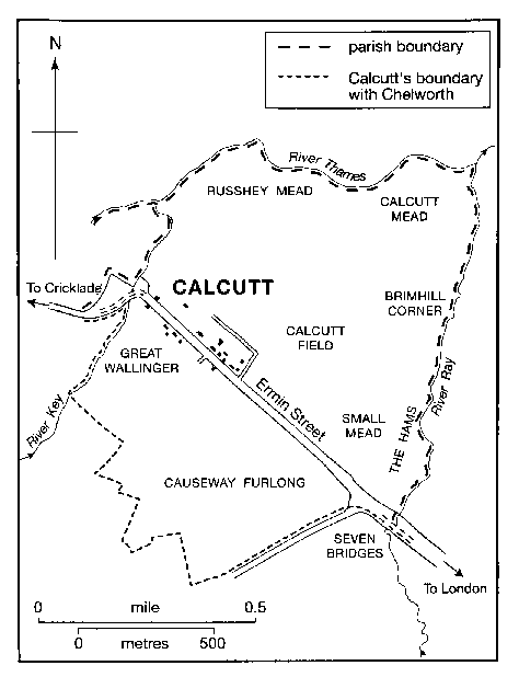
MAP 9. Calcutt c. 1800.
Commonable land and inclosure
Calcutt had c. 185 a. of
open fields. (fn. 744) Early 16th-century references to North
and South fields suggest that one was laid out on each
side of Ermin Street. (fn. 745) They may already have been subdivided by the 16th century, and divisions called Calcutt
field and Brimhill corner lay north-east of the road, and
south-west lay Causeway furlong, Great and Little
Wallinger, Sinderhams, and Picked furlong. (fn. 746) As at
Chelworth, in the early 18th century parts of the fields
on both sides of Ermin Street were being used for a hay
crop. (fn. 747) Although most of the land in the open fields was
cultivated from Calcutt, some came to be added to
farms based in Chelworth. (fn. 748)
Calcutt had c. 148 a. of commonable meadows. (fn. 749) In the Middle Ages the first cut of the whole of Russhey mead was part of Cirencester abbey's demesne, along with the first cut of c. 130 a. of adjoining meadow land in Eisey and Latton parishes; it was kept in hand in the early 16th century. (fn. 750) From Lammas to Lady day Russhey mead was used as a common pasture for cattle by those with farmsteads at Calcutt. (fn. 751) Calcutt mead, 60 a., lay in the angle of the Thames and the Ray; (fn. 752) much of it was apparently divided into plots permanently attached to specific holdings; part of it lay in plots which were assigned each year by lot. (fn. 753) From Lady day to 31 July the grass from each plot was taken by the owner or tenant of the plot, and from Lammas the whole meadow was grazed by the cattle of each of those with a plot in it. (fn. 754) Small mead, c. 46 a., lay beside the Ray south of Calcutt mead. (fn. 755)
Much of Calcutt's land was inclosed piecemeal. In 1623 the occupier of a plot in Calcutt inclosed it with a hedge and ditch, claiming that these were necessary to improve drainage and that on 1 August he opened a gap in the hedge so that the cattle of others could enter on his plot; the occupiers of other plots broke down parts of the hedge, and Calcutt mead then remained open. (fn. 756) Between 1654 and 1677 c. 30 a. of Small mead had been inclosed as the Hams. (fn. 757) Part of Calcutt field and all or part of Sinderhams had been inclosed by 1708, (fn. 758) and much of the open fields had apparently been inclosed by 1772. (fn. 759) By 1793 the part of Calcutt field which lay between the village and Russhey mead had been inclosed, and some of the furlongs east and south-east of the village. South-west of Ermin Street much of Causeway furlong had apparently been inclosed by the 1790s. (fn. 760) There was no large farm at Calcutt before the 19th century, and uncontested inclosure presumably followed the consolidation of lands by purchase or exchange and the surrender of feeding rights over uninclosed land.
Owners of Calcutt's land claimed feeding rights on Chelworth common and successfully opposed the inclosure bill of 1789, which would have abolished them. They did not oppose the bill of 1814 which eventually abolished their rights, because it set out land exchanges which made their farms more compact. (fn. 761) 122 a. of Russhey mead, Calcutt mead, and the remainder of Small mead were all inclosed under the Act, as was the remaining c. 58 a. of open-field land. (fn. 762) Common husbandry at Calcutt ended in 1816–17 when the provisions of the Act came into effect. (fn. 763)
Farms and farming
In 1086 there were 4½ hides of
arable land at Calcutt in demesne; land was also
cultivated by the households of one villanus, four
bordars, and one servus, with one ploughteam between
them. (fn. 764) Later, if not then, the land lay in small holdings
with farmsteads beside Ermin Street, (fn. 765) and several of the
manors and estates into which Chelworth's land was
divided included land at Calcutt. In the later 14th
century an estate based in Chelworth included 1
yardland at Calcutt held customarily, (fn. 766) and another
included two messuages and one carucate there; (fn. 767) in 1372
Little Chelworth manor included four customary
holdings there. (fn. 768) By 1450 the lord of Little Chelworth
manor had transferred his pasture rights in Dudgemore
from his demesne in Chelworth to his customary
holdings with farmsteads at Calcutt. (fn. 769) In the earlier 16th
century Abingdon Court manor included a copyhold
consisting of a messuage and 1 yardland at Calcutt. (fn. 770)
There were probably about eight farms based at Calcutt in the 17th century, (fn. 771) and most of them apparently remained small then and for much of the 18th century. In 1621 Little Chelworth manor included 141 a. of Calcutt's land, c. 40 per cent; 6 a. was demesne and 135 a. lay in five copyholds. The copyholds had a total of 48 a. of meadow land, 87 a. of arable, and the right to feed 54 beasts in Dudgemore; the copyholds varied in size from 41 a. to 24 a., and there was a farmstead and a home close in each. (fn. 772) All the holdings were later freehold, three of them from 1654; each of the three included a 4-a. close in Dudgemore and the right to feed 12 beasts in Russhey mead. (fn. 773) There was also a 49a. farm at Calcutt in 1654, (fn. 774) and in 1770 there were farms of 37 a. and 29 a. (fn. 775) The largest farm in the 17th century was apparently that later called Calcutt farm; it was merged with another farm in the later 17th century, from when it was probably over 100 a. Apparently between 1733 and 1772 two other farms were merged to form a holding of 72 a. As the open fields were inclosed piecemeal and new closes laid to grass the farms came to have more grassland than arable and were used primarily for cattle rearing. (fn. 776)
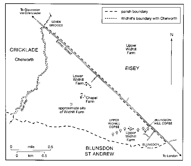
MAP 10. Widhill tithing in 1838.
In 1811 the two largest farms at Calcutt were occupied by their owners. Calcutt farm was of 185 a., including 46 a. of leased land; the other was of 86 a. (fn. 777) In 1817 there was also a farm of c. 60 a. (fn. 778) All the farms were made more compact in 1816–17. In 1842 there were four based on Ermin Street; Calcutt farm was of 154 a.; the second farm was of 151 a. and included Oxhouse farm and land in Chelworth; the third of 31 a. was held with Fiddle farm, 39 a. in Chelworth; and the fourth was of 22 a. Most of the land was meadow and pasture; Calcutt farm included 43 a. of arable, of which 18 a. lay in Chelworth. About 18 a. was part of a farm with buildings north-west of St Mary's church. (fn. 779) In 1857 the tenant of Calcutt farm occupied 274 a. and there were farms of 61 a., 31 a., and 22 a. based at Calcutt. (fn. 780) That of 31 a. was a dairy farm in 1883. (fn. 781)
In 1928 there were three farms at Calcutt: Calcutt farm, 193 a., and Calcutt Hall farm, 68 a., each had buildings on the north-east side of Ermin Street, and Calcutt Court farm, 77 a., had buildings on the southwest side. (fn. 782) All were entirely grassland and were presumably dairy farms. (fn. 783) About 1949 that part of Calcutt farm south-west of Ermin Street was assigned to a new farm, Kingshill, with buildings on Chelworth's land on that side of the street, (fn. 784) and from the 1970s nearly all of Calcutt's land north-east of the street was part of Manor farm, Water Eaton. From the 1970s until 2003 large buildings were used as a dairy on Manor farm, a large arable and dairy farm. (fn. 785) Nearly all Calcutt's land on both sides of Ermin Street remained under grass in 2003.
WIDHILL
There was commonable land at Widhill in the Middle Ages. (fn. 786) North Widhill and West Widhill were separate settlements and it is not clear whether they shared a single set of open fields, commonable meadows and pastures, or whether each had some or all of its own set. In the 13th century each had a pasture called the Marsh and a meadow called Tornesye, suggesting a division. (fn. 787) Evidence of the 18th century indicates that there were open fields near the settlements, that the Marsh lay between the settlements and Ermin Street, that to the west there were extensive meadows beside the Ray, and that to the east Widhill's part of Blunsdon Hill was pasture. (fn. 788)
In 1086 Widhill was said to have land for eight ploughteams although only five were there. At North Widhill there was only demesne land, on which there were two ploughs and the households of two servi and six bordars; at West Widhill there was 4 hides of demesne on which there were two teams, and there were two villani, four bordars, and one team. (fn. 789) Later in the Middle Ages the only holdings of which there is evidence were small. Of Adam of Stratton's 10 free tenants at Widhill in 1276–7 six held 1 yardland each and four ½ yardland each, (fn. 790) and there is other evidence of holdings of 1½ yardland and less. (fn. 791)
By a process which is obscure, and which probably began in the 15th century, nearly all Widhill's land was merged into a single farm, possibly completed by 1588. (fn. 792) Common husbandry was eliminated by the merger, but there were vestiges of it. In 1605 the vicar of St Sampson's held 1 a. in each of two meadows and 2 a. of arable, presumably plots in a formerly commonable meadow and a strip in a formerly open field; (fn. 793) c. 1780, when it was said that the common pasture had been inclosed a great many years previously, the owner of an estate otherwise at Broad Blunsdon held 1 a. at Widhill defined by landmarks in a larger close and was awarded compensation for the loss of common feeding for four beasts. (fn. 794) The hill at the east end of Widhill, which had formerly been a common pasture, was sown with wheat by the 1680s. (fn. 795)
Widhill farm was taken over by the owner's creditors c. 1680–1707, and the fences between the closes were allowed to decay. (fn. 796) Two new farmsteads were built probably between 1707 and 1709, and in that period the farm, c. 700 a., was apparently divided into three. In 1709 the land lay in 35 closes, the largest of which was North field, 83 a., and included 140 a. or more of meadows. (fn. 797) There were three farms in 1780. (fn. 798) In 1810 all three were dairy farms apparently producing cheese. Lower Widhill farm, 253 a., and Chapel farm, 265 a., were entirely grassland; Upper Widhill farm, 218 a., included 70 a. of arable, presumably on the hill. (fn. 799) By 1837 an additional 105 a. had been ploughed: Lower Widhill farm then had 26 a. of arable, Chapel farm 41 a., and Upper Widhill farm 108 a. (fn. 800) From 1857 to 1915 Chapel farm and Upper farm were held together. (fn. 801)
From 1915 Chapel farm, Lower farm, and Upper farm were held separately. (fn. 802) In 1928 they were of 303 a., 226 a., and 169 a. respectively. (fn. 803) The only arable in the mid 1930s was c. 20 a. at Widhill's east end. (fn. 804) In the later 20th century all three farms were dairy farms. Dairying ceased at Upper farm c. 1996 and at Lower farm c. 2000. From 1987 much of Chapel farm was used for refuse disposal; dairy farming on it ceased in 2003. (fn. 805) Nearly all the land of each farm remained under grass in 2004.
Upper Widhill copse, 5 a. on the brow of the hill, was standing in 1709; (fn. 806) Blunsdon hill copse, 4 a. east of it, had been planted by 1837. (fn. 807) Both copses were standing in 2003.
A water mill stood by the Ray at Widhill in 1086, (fn. 808) which was evidently standing in 1344, (fn. 809) but may not have survived long afterwards. It had been demolished by 1709; (fn. 810) its exact site is unknown.
Wiltshire County Council bought Chapel farm to use for refuse disposal, and 120 a. along Widhill's south boundary was assigned for the purpose. Rubbish was tipped into large holes dug in the clay; tipping began in 1987 and continued in 2003. (fn. 811)
BRAYDON FOREST
The south-west part of St Sampson's parish, into which part of Purton intruded, is clay land and in the early Middle Ages was presumably woodland. The boundary between the woodland and the early assarts of Chelworth probably ran near the moat on Chelworth farm. (fn. 812) As part of Braydon forest the woodland was made subject to the forest law by 1135, and it remained part of the forest at every definition of the forest's boundary. (fn. 813) The only assarts likely to have been made from it were at its east end, where c. 110 a. west and south of the moat may have been added to Chelworth farm and c. 55 a. south-east of the moat may have been added to Whitehall farm. A 64-a. field immediately south-west of the moat called the Great Purlieu was part of Chelworth farm, and became Purley farm. (fn. 814)
The U-shaped south-west part of St Sampson's parish measured c. 2,500 a. (fn. 815) Subject to the forest law, as the king's demesne from 1326, and constituting about a third of Braydon forest as defined in 1330, (fn. 816) it was presumably used for hunting by the king or his licensees or lessees. In the early 17th century it was mostly woodland and woody ground. The commonest trees then were probably pollarded oaks, and there were two lodges for keepers of the forest, Old Lodge and Slyfield Lodge. (fn. 817)
By the early 17th century four coppices had been inclosed, presumably for commercial forestry; Littlemore coppice, c. 90 a., and White Spire coppice, c. 28 a., stood north of the tongue, Ravenshurst coppice, c. 30 a., to the west, and Stonyhurst coppice, c. 30 a., to the south. (fn. 818) Also by then it had become the custom for the cattle and sheep of those living in Chelworth and nearby villages to depasture at large in the forest. The inclosure of coppices and the feeding of cattle reduced the amount of food available for deer, the number of which may have fallen. (fn. 819) In 1604 the king ordered that a sanctuary for deer should be inclosed within the forest and sought to inclose a feeding place for them outside, and in 1613 he bought hay to feed them. (fn. 820)
In 1630 the Exchequer court confirmed that the Crown owned all the land in St Sampson's parish south-west of the moat on Chelworth farm apart from the Great Purlieu. Common rights over the Crown's land were extinguished and as compensation the Crown gave 150 a. north-west of the Great Purlieu to the lords and freeholders of Chelworth and 100 a. west of it to the poor of Cricklade and Chelworth. (fn. 821) In 1636 the Crown leased its land, 1,781 a., in portions and expressly licensed the conversion of woodland to farmland. (fn. 822) The conversion had apparently been completed by 1651, despite the action of nearby paupers who, during and after the Civil War, destroyed fences in an attempt to revive their rights or claims over the land. Boundaries had been planted to make c. 57 closes and, unlike the early assarts of Chelworth, most were straight. (fn. 823)
In 1651 Old Lodge and Slyfield Lodge were farmhouses, and buildings near Old Lodge included a five-bayed barn and a milk house. Littlemore coppice had been cleared and laid to grass and, at c. 90 a., was the largest close; the other closes ranged from c. 7 a. to c. 55 a. and in 1651 some were arable. (fn. 824) In the 18th century Old Lodge (later Great Lodge, Ravenshouse, and Ravenshurst) farm and Slyfield Lodge (later Leighfield Lodge) farm may have remained large, but after 1651 much land was sublet in portions, closes were divided, and new farmsteads were built. About 1800 the land lay in c. 135 closes and about half was arable. Besides Great Lodge Farm and Leighfield Lodge Farm, buildings stood on eight sites, including those of Gospel Oak Farm and Duchy Rag Farm; King's Barn Farm had been built on the 150 a. since 1788, when the land was inclosed. Leighfield Lodge farm and Duchy Rag farm seem to have been mainly arable. (fn. 825)
Leighfield Lodge farm was a compact farm of 702 a. in 1816, (fn. 826) and a dairy herd of 30 cows was kept on it in 1826; (fn. 827) by 1842 land had been taken from it to form Leighfield Cottage farm. (fn. 828) In 1823 Great Lodge farm, 435 a., included 280 a. of grassland, c. 100 a. of arable, and 44 a. of woodland. (fn. 829) In 1827 Duchy Rag (later Gryphon Lodge) farm consisted of a newly built farmstead and 258 a. in 12 closes. (fn. 830) In 1842 there were eight farms, Gospel Oak, 483 a., Ravenshouse, 364 a., Leighfield Lodge, 346 a., Leighfield Cottage, 270 a., Duchy Rag, 251 a., King's Barn, 44 a., and one of 70 a. and one of 31 a. at the west end of the parish. They included only 138 a. of arable, of which 70 a. lay in Gospel Oak farm. Duchy Rag farm had only 23 a. of arable; Leighfield Lodge and King's Barn farms were entirely meadow land and pasture. (fn. 831)
Between 1842 and 1875 more new farmsteads were built and presumably some farms were made smaller. Lower Farm, Lower Bury Hill Farm, and White Lodge and farm buildings were erected on the eastern lands of what had been Gospel Oak farm, and Ravensbrook Farm replaced the farmsteads of the 70-a. and 31-a. farms. The land of what had been Leighfield Lodge farm was further subdivided: farms began to be worked from buildings erected beside Braydon Cottage and from Lower Sales Farm, built north-west of Leighfield Lodge. (fn. 832) In 1910 there were c. 11 farms, of which the largest were Ravenshurst, 333 a., and Gryphon Lodge, 212 a.; some of the 182 a. leased without buildings was apparently part of farms worked from farmsteads outside the parish, and some of the farms with farmsteads in the parish may have had land outside. (fn. 833) There was an additional farm from when, c. 1920, Wiltshire County Council leased out what had formerly been part of Leighfield Cottage farm as South Leigh farm, a 71-a. dairy farm. (fn. 834) Nearly all the farms were entirely pasture: in 1936 a 14-a. field near White Lodge was the only arable. (fn. 835) King's Barn farm, 61 a. in 1928, and much of the 184 a. of Leighfield Lodge farm were taken for the airfield of RAF Blakehill Farm in 1943. (fn. 836) In the 1940s and 1950s White Lodge farm, worked from the buildings formerly called Lone Barn Farm, was a mixed farm of 365 a. (fn. 837)
In the late 20th century the number of farms in the south-west part of St Sampson's parish declined, as it did in the other parts. In 2003 nearly all the land was grassland. The only dairy farms with their principal buildings in that part of the parish were White Lodge farm and Leighfield Cottage farm; White Lodge farm was then of 350 a. (fn. 838) Bridge farm and land nearby were part of a 500-a. farm based in Ashton Keynes. (fn. 839) The land of the airfield, little used for flying after 1947, became a nature reserve in 2000.
In the earlier 19th century the 100 a. (actually 104 a.) assigned by the Crown to trustees of the poor of Cricklade and Chelworth was being leased yearly by auction. (fn. 840) From the 1840s to the earlier 20th century 78 a. was leased as garden allotments. The cultivation of allotments had declined by 1939, when the Wiltshire War Agricultural Executive Committee ordered that uncultivated allotments should be ploughed up, and the 104 a. was requisitioned by the Air Ministry in 1943. (fn. 841) In 2003 the 104 a. was grassland and most of it lay in the nature reserve. (fn. 842) Between 1875 and 1898 c. 38 a. beside the Malmesbury road was converted to garden allotments, and there was 63 a. of allotments in 1910. The land reverted to farmland apparently in the 1920s. (fn. 843)
After the mid 17th-century conversion to farmland there remained only 44 a. of woodland in what had been the part of Braydon forest in St Sampson's parish. (fn. 844) That woodland is part of Ravensroost wood, 96 a., the rest of which stands in Braydon parish. From 1922 to c. 1980 it was used commercially and for shooting game birds. In 1987 the whole wood, designated a Site of Special Scientific Interest, was bought by the Wiltshire Trust for Nature Conservation; it has since been managed as a nature reserve. (fn. 845) On Coxe's hill east of Duchy Rag Farm 43 a., which had been farmland c. 1800, in 1842, and possibly in 1875, (fn. 846) was gorse in 1901, and used for hunting and shooting. (fn. 847) In the early 20th century it was leased to the Vale of the White Horse hunt. (fn. 848) It remained rough land in 1936 (fn. 849) and was later farmland.
Between 1841 and 1875 a brickworks was opened beside the Malmesbury road; the pits from which clay was dug on the 7-a. site had been flooded, and the brickworks apparently closed by 1898. (fn. 850)