A History of the County of York East Riding: Volume 3, Ouse and Derwent Wapentake, and Part of Harthill Wapentake. Originally published by Victoria County History, London, 1976.
This free content was digitised by double rekeying. All rights reserved.
'Harthill Wapentake', in A History of the County of York East Riding: Volume 3, Ouse and Derwent Wapentake, and Part of Harthill Wapentake, (London, 1976) pp. 129-132. British History Online https://www.british-history.ac.uk/vch/yorks/east/vol3/pp129-132 [accessed 19 April 2024]
HARTHILL WAPENTAKE
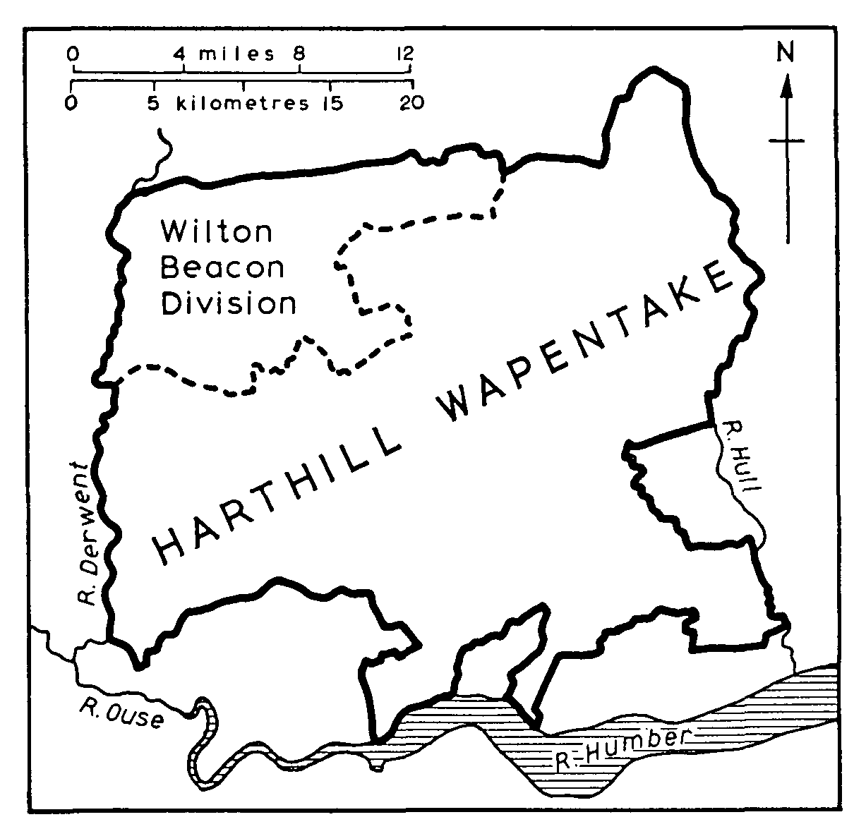
The Wapentake, the largest in the East Riding, extends from the river Hull in the east to the river Derwent in the west, and in places reaches the Humber in the south. A great variety of landscape is consequently contained in it, ranging from the low-lying ground of the Vale of York and the Hull valley to the higher country of the Yorkshire Wolds and the Jurassic hills. All areas are still largely rural and agricultural, but the proximity of Beverley and, more especially, of Kingston upon Hull has brought changes to the surrounding countryside.
In the Vale of York much of the land lies at about 25 ft. above sea-level and, as in Ouse and Derwent wapentake, consists of drift deposits of clay, sand, and silt. The most noticeable relief features are the Escrick moraine, which continues into the wapentake from the west side of the Derwent, and Church hill at Holme upon Spalding Moor. The boulder clay and gravel of the moraine reach 50 ft. and more above sea-level, while the Keuper marl outcrop at Holme hill exceeds 150 ft. The name Jurassic hills is applied to a stretch of undulating country, up to 2 miles wide, along the eastern side of the Vale of York. Formed in part of limestone, they reach about 50 ft.-200 ft. and their most prominent feature is a small escarpment which gives its name to the villages of North and South Cliffe. Behind the Jurassic hills rises the altogether more impressive escarpment of the wolds. Close to the escarpment the chalk hills in places exceed 500 ft. above sea-level, and on the northern boundary of the wapentake, at Bishop Wilton, they reach 800 ft., the highest point in the riding. In Harthill as elsewhere the wolds are dissected by numerous steep-sided dry valleys. Boulder clay covers the chalk on the lower eastern slopes of the wolds, down which numerous streams flow towards the river Hull. The flat silt- and peat-covered floor of the Hull valley, nowhere exceeding 25 ft. above sealevel, occupies the last 2 or 3 miles before the eastern boundary of the wapentake is reached. (fn. 1)
Most of the villages in the Vale of York stand on ground rising only slightly above the generally low level. In the Jurassic hills streams flowing from the wolds escarpment provided sites for many of the settlements, while a line of villages is strung out beneath the escarpment itself. On the higher parts of the wolds villages are few and mostly confined to sheltered valleys, but the lower slopes are densely settled, with many villages placed near the upper and lower margins of the boulder clay. The few old settlements in the Hull valley were sited, as in the Vale of York, on 'islands' of drier ground.
Much of the wolds was occupied here, as in Dickering wapentake, (fn. 2) by open-field arable land and sheepwalks until the 18th and early 19th centuries, when the agricultural landscape was transformed by parliamentary inclosure. In contrast parts of the Vale of York experienced a more varied agricultural development, already noted in Ouse and Derwent wapentake, (fn. 3) and in both the Vale of York and the Hull valley the draining of marshland has been of special significance. Building materials in the wapentake are equally varied. Limestone houses are still common in the Jurassic hills, but on the wolds chalk is now generally confined to farm buildings, and both there and in the Vale of York the brick-built houses mostly date from the 18th century and later.
The wapentake includes three small market towns, Pocklington and Market Weighton in the Vale of York and Great Driffield on the eastern slopes of the wolds. From the 18th century onwards several of the villages in the south-east of the wapentake have gradually expanded as dormitories for Hull, and in the present century similar but more rapid growth has taken place around both Hull and Beverley. Some industrial development has occurred there, too, as well as in the market towns and in several villages where rivers, canals, and railways have provided facilities for transport.
The Domesday hundreds in the East Riding were transformed into wapentakes during the 12th century. (fn. 4) Harthill wapentake, first mentioned in 1166, (fn. 5) was made up of Driffield, Hessle, and Weighton hundreds, and parts of Cave, Pocklington, Sneculfcros, Warter, and Welton hundreds.
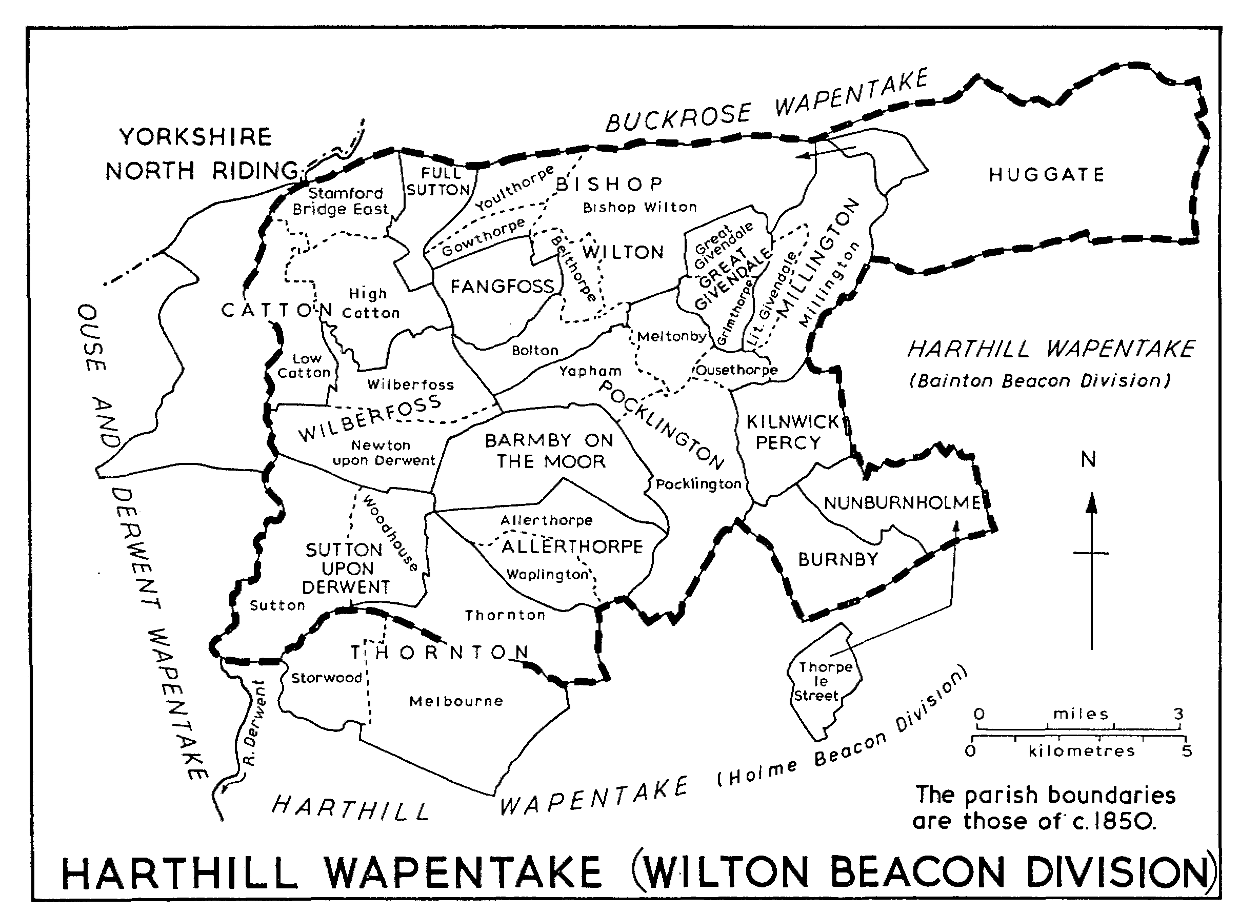
HARTHILL WAPENTAKE (WILTON BEACON DIVISION)
From Driffield hundred the wapentake drew the townships of Bainton, 'Cheldale' (in Driffield), Cranswick, Great and Little Driffield, Eastburn, part of Elmswell, Hutton, Kelleythorpe, Kirkburn, Neswick, Rotsea, Skerne, Southburn, Sunderlandwick, Tibthorpe, and 'Torp'. (fn. 6) The rest of Elmswell, which lay in Turbar hundred in 1086, later became part of Harthill wapentake. (fn. 7) The hundred meeting-place may have been near Spellow Farm, Elmswell, a name deriving from 'speech mound'. (fn. 8) Hessle hundred contributed to the wapentake the townships of Anlaby, Breighton, Bubwith, 'Crachetorp' (possibly Tranby), Kirk Ella, North Ferriby, Gunby, Hessle, Newsholme, Myton, Riplingham, 'Siwarbi' (possibly Loftsome), Spaldington, 'Totfled', part of Wauldby, Willerby, Willitoft, Wolfreton, and Wressle. (fn. 9)
From Weighton hundred the wapentake took the townships of Bishop Burton, Cleaving, North Cliffe, Easthorpe, Goodmanham, Harswell, Holme upon Spalding Moor, Houghton, Kiplingcotes, Londesborough, Sancton, Shipton, Thorpe, Towthorpe, and Market Weighton. (fn. 10) Welton hundred contributed Bentley, part of Brantingham, Cottingham, Elloughton, Lund, 'Pileford' (in Cottingham), Risby, Skidby, part of Walkington, the rest of Wauldby, and Little Weighton. (fn. 11)
From Cave hundred the wapentake drew the townships of Aughton, North and South Cave, 'Chetelstorp' (probably in Storwood), South Cliffe, East Cottingwith, Drewton, Ellerton, Everthorpe, Foggathorpe, Gribthorpe, Hotham, Hunsley, Kettlethorpe, Laytham, Melbourne, Newbald, Seaton Ross, and Thornton. (fn. 12) From Pocklington hundred it drew the townships of Allerthorpe, Barmby Moor, Beilby, Belthorpe, Bolton, Burnby, Catton, Everingham, Fangfoss, Gowthorpe, Greenwick, Hayton, Pocklington, Sutton upon Derwent, Thorpe le Street, Waplington, Bishop Wilton, and Youlthorpe. (fn. 13) Sneculfcros contributed Aike, Beswick, Bracken, Cherry Burton, South Dalton, Etton, Gardham, Holme on the Wolds, Kilnwick, Leconfield, Lockington, Middleton on the Wolds, Newsham (possibly in Leconfield), Newton (in Cherry Burton), 'Persene' (perhaps in Scorborough), Raventhorpe, Scorborough, 'Steintorp' and 'Torp' (both possibly in Etton), and Watton. (fn. 14) The hundred meeting-place was presumably at Sneculf's cross, the location of which is unknown. (fn. 15) Finally, Warter hundred contributed to the wapentake the townships of North Dalton, Great and Little Givendale, Grimthorpe, Hawold, Huggate, Kilnwick Percy, Meltonby, Millington, Nunburnholme, Ousethorpe, Warter, and Yapham. (fn. 16)
HARTHILL WAPENTAKE
Among the places not mentioned in 1086 but which later lay within the wapentake were Arram, Arras, Brind, Broomfleet, Brough, Bursea, Faxfleet, Harlthorpe, Hundburton, Newton (in Cottingham), Newton upon Derwent, Rowley, Sculcoates, Stamford Bridge, Storwood, Full Sutton, Swanland, Wholsea, and Wilberfoss, all recorded from the 12th or 13th centuries. The wapentake also includes New Village, which has existed only since the late 18th century. (fn. 17)
The uncertain early relationship between Howdenshire and the wapentakes of Harthill and Ouse and Derwent has been discussed above. (fn. 18) Howdenshire emerged as a distinct wapentake by the mid 14th century. It comprised a large block around Howden itself, together with Ellerker, Melton, Welton, large parts of Brantingham and Walkington, and smaller parts of several other townships, all lying detached within Harthill wapentake. The whole of Brantingham and Walkington are reserved for treatment under Howdenshire.
The area of Harthill wapentake was reduced in 1299 by the creation of the borough of Kingston upon Hull, and again in 1440 when Hull was erected into a county of its own and the township of Myton was included in it. The enlargement of the county of Hull in 1447 involved the further removal from Harthill of the parishes of Hessle, with its township of Tranby, North Ferriby, with the township of Swanland, and Kirk Ella, with the townships of Anlaby, West Ella, Willerby, and Wolfreton. Haltemprice priory, which occupied the site of the former township of Newton, in Cottingham, was also included in the county of Hull in 1447. The county's boundaries thereafter remained unchanged until 1835, when they were reduced to become coextensive with those of the borough. (fn. 19) The former outlying parts of the county are reserved for treatment elsewhere.
Extensions to the boundaries of the borough in the 19th and 20th centuries have taken in the whole of Sculcoates parish and part of Cottingham. The history of Sculcoates was accordingly dealt with along with that of the rest of the city of Hull. (fn. 20) Most of Cottingham, including the village itself, remains outside the city and the history of the whole parish will be treated under Harthill wapentake.
The wapentake remained with the Crown until at least the 17th century. The office of wapentake bailiff was granted for life to successive holders in 1542, 1552, and 1567. (fn. 21) A new bailiff was appointed in 1619-20. (fn. 22)
The meeting-place of the wapentake was presumably Hart hill; its site is not known but it may have been in the neighbourhood of Market Weighton. (fn. 23) At least some of the townships paid a share of the wapentake fine and owed suit at the court. (fn. 24) The sheriff accounted for 53 marks from the wapentake in 1399-1400, (fn. 25) and in the 16th and 17th centuries he received nearly £6 in blanch farm from Harthill. (fn. 26)
The four divisions of the wapentake, namely Bainton Beacon, Holme Beacon, Hunsley Beacon, and Wilton Beacon, first appear in Elizabeth I's reign. (fn. 27) They were probably created as areas of assessment for the maintenance of the beacons that stood at Bainton, Holme upon Spalding Moor, Hunsley, and Bishop Wilton. (fn. 28) There was a beacon at Hunsley by 1537. (fn. 29) Part of Wilton Beacon division is dealt with in this volume.