A History of the County of Sussex: Volume 5 Part 1, Arundel Rape: South-Western Part, Including Arundel. Originally published by Victoria County History, London, 1997.
This free content was digitised by double rekeying. All rights reserved.
'Arundel', in A History of the County of Sussex: Volume 5 Part 1, Arundel Rape: South-Western Part, Including Arundel, (London, 1997) pp. 10-101. British History Online https://www.british-history.ac.uk/vch/sussex/vol5/pt1/pp10-101 [accessed 19 April 2024]
In this section
ARUNDEL

ARUNDEL AND SOUTH STOKE c. 1875
General History of the Town, p. 12. The Town as a County Centre, p. 15. Military Events, p. 15. Growth of the Town, p. 19. Secular Buildings, p. 24. Defences, p. 28. Religious Houses, p. 29. Communications, p. 32. Social and Cultural Activities, p. 35. Castle, p. 38. Castle Grounds, p. 49. Woods and Parks, p. 51. Manor and Other Estates, p. 55. Agriculture, p. 56. Mills, p. 60. Markets and Fairs, p. 61. Port and River Traffic, p. 62. Timber Trades, p. 66. Other Trades and Industries, p. 68. Professions, p. 73. Borough Government, p. 73. Manorial and Parochial Government, p. 81. Parliamentary Representation, p. 83. Public Services, p. 84. Church, p. 86. Roman Catholicism, p. 95. Protestant Nonconformity, p. 97. Education, p. 99. Charities for the Poor, p. 101.
The former borough of Arundel, (fn. 1) dominated by its castle and 19th-century Roman Catholic church, later cathedral, lies c. 3 miles (5 km.) from Littlehampton, at the lowest point where the river Arun could be bridged.
The borough and civil parish were co-extensive in the early 19th century (fn. 2) and possibly earlier. (fn. 3) In 1881 they consisted of 1,969 a. including water. In 1902 they were enlarged on the south side by the addition of the north-east corner of Tortington (c. 85 a.), together with a strip of waste land belonging to the same parish north of Chichester Road. In 1911 and 1971 Arundel had 2,054 a. (831 ha.). (fn. 4) Most of the rest of the ancient parish of Tortington was transferred to Arundel in 1985. (fn. 5) The present article deals broadly with Arundel parish as constituted before the last named date. (fn. 6)
The parish in past centuries included arable north-west of the town, since converted to other uses, together with downland pasture in the same area; riverside meadow in the south and east; and forest and parkland, the latter afterwards converted to agriculture, on the shallower soil of the west and north-west. (fn. 7) In the east the boundary followed a meander of the river Arun, evidently to include the meadow later known as the burgess brooks. The south-eastern boundary, including other meadow called the south marshes, also follows a watercourse which, however, pace Allcroft, apparently never was the main course of the river. (fn. 8) Part of the western boundary follows a linear earthwork, possibly prehistoric, (fn. 9) which also served as the boundary of Rewell wood west of the medieval Great park. In 1605 part of that boundary was disputed between Arundel and Madehurst. (fn. 10)
The parish lies largely on chalk, overlain in the south-west by brickearth, valley gravel, and Reading Beds clay, and in the river valley and in Park bottom west of the town by alluvium. (fn. 11) North and west of the town the ground rises on the dip slope of the South Downs to between 100 and 125 metres (328 and 410 ft.), giving fine views of the coastal plain; beyond the northwestern boundary it falls sharply away to Fairmile bottom in Madehurst. Park bottom west of the town and Pughdean bottom to the north are valleys in the chalk, in each of which a stream formed a pond. Swanbourne lake in Pughdean bottom, a former mill pond, lies in South Stoke. Park bottom may once have been an inlet of the river Arun, since the town gate at the west end of Maltravers Street was known as the Watergate. In the mid 17th century, when the pond there was called the great pond, it was 17 a. in area. (fn. 12) By 1732 it had been drained, forming a close later called the Boggy meads. (fn. 13)
The river Arun seems in Roman times to have formed a wide tidal estuary, (fn. 14) its Celtic name Trisantona (i.e. Tarrant) perhaps alluding to its proneness to flooding. (fn. 15) The depth of alluvium at more than one place near the town is over 30 metres (100 ft.). (fn. 16) In the early Middle Ages there may have been more than one channel, as in the river Adur at Bramber, (fn. 17) but the often repeated, yet erroneous, statement that the present course of the river past the town was newly cut by the earl of Arundel in the mid 16th century (fn. 18) seems to derive from misconstruction of a 17th-century reference to river improvement higher up the valley. (fn. 19) The name Tarrant is recorded c. 725 and c. 1270, but the normal medieval name was apparently the river of Arundel, Arundel river, or the high stream of Arundel. (fn. 20) The modern name is recorded from 1577, (fn. 21) but the names Arundel river or great river continued to be used later. (fn. 22) In the 20th century the Arun was said to be the second fastest flowing river in the country, with a speed of up to seven knots at full flood. (fn. 23)
The area later called the burgess brooks had been inned by the late 11th or early 12th century, when the burgesses had pasture rights there. (fn. 24) Several meadow of 84 a. mentioned in 1272 (fn. 25) was presumably what later became the south marshes; the hay on 75 a. was said in 1275 to have been destroyed by floods. (fn. 26) The 100 a. of meadow belonging to the castle in 1386 (fn. 27) was evidently the same. River defences in Arundel are perhaps alluded to in the late 14th century, (fn. 28) and there are references to inning in the area in the 1540s. (fn. 29) The burgess brooks had defences against flooding in 1546 (fn. 30) and the south marshes apparently in 1570. (fn. 31) A particularly destructive flood was recorded in 1509. (fn. 32)
In the burgess brooks in the 17th and 18th centuries a river wall, i.e. bank, delimited brookland pasture from strips of land called slips or slipes outside; osiers or reeds grew on the slipes in the earlier 17th century, but by 1761 the land provided good pasture, one slipe having been mowed regularly for c. 60 years. (fn. 33) An outer bank was constructed to include the slipes, apparently by 1782 and certainly by 1799. (fn. 34) Under an Act of 1793 a towpath was made from Arundel to Littlehampton on the west side of the river. (fn. 35) Further severe floods were recorded in 1774, in 1809, (fn. 36) and later in the 19th century and early 20th, possibly exacerbated by dredging, embanking, and the elimination of meanders above the town, which increased the volume and force of water in the river. (fn. 37) The river bank was raised in 1834. (fn. 38)
The fishing of the river at Arundel was held in demesne by the lords of the rape from 1086 (fn. 39) or earlier, often being farmed. (fn. 40) The fishing of a weir (gurgite), perhaps at Swanbourne, was also mentioned in 1272; (fn. 41) in 1421 and presumably earlier the earl of Arundel's fishery extended from the sea as far upstream as Pallingham in Wisborough Green. (fn. 42) In the 17th century (fn. 43) and again in the mid 19th (fn. 44) the lords of the rape acted strenuously to preserve their rights to the river, though in 1658 there was only poor fishing since the river was full of weeds. (fn. 45) The Arundel estate still claimed the bed of the river from the sea to Pallingham in 1980, letting fishing rights to local clubs and mooring rights to individuals. (fn. 46) Pike and eel were abundant in 1817, (fn. 47) but the grey mullet caught between Arundel and the sea had a special reputation for size and flavour from the mid 17th century, being praised by Isaak Walton and Thomas Fuller, and the subject of a rhyme. (fn. 48) In the 1650s and 60s mullet were sent both to Arundel House in London and to Henry Howard's house at Albury (Surr.), and in the 18th century and early 19th to London. (fn. 49) Large quantities were netted c. 1907, but catches afterwards became rarer, (fn. 50) though they still occurred in 1991. (fn. 51) The name mullet has been used as a sobriquet for natives of the town.
GENERAL HISTORY OF THE TOWN.
There are traces of prehistoric settlement, including a field system, in the west end of the parish, (fn. 52) and there was possibly a prehistoric earthwork on the site of Arundel castle. (fn. 53) A large and luxurious Roman villa, with a hypocaust, mosaic work, and much painted plaster, was built in the 1st century A.D. between the west end of Tarrant Street and the river Arun. Comparable to those at Angmering and elsewhere in Sussex, and accessible both from the river and from the Roman road between Chichester and Brighton, it may be the successor to a pre-Roman nobleman's farm. (fn. 54) No later Roman settlement in the parish is known.
There was apparently a minster church at Arundel before the Norman Conquest, suggesting an important Anglo-Saxon settlement, but the entry in Domesday Book is equivocal. (fn. 55) Possibly the earthworks north-west of the castle represent a late Saxon burh succeeding that at Burpham 1½ miles (2.4 km.) north-east, in the same way that Guildford (Surr.) replaced Eashing. (fn. 56) Their site is traversed from north to south by a presumably ancient road; it would have been a likely one for settlement, and there may already have been a small port on the river. (fn. 57)
By 1086 Arundel was a town with burgesses. (fn. 58) In the Middle Ages it was very much under the domination of the lords of the rape, both economically and in other ways, and also served as the centre of rape administration. The prosperity of the town in the later 13th century is perhaps shown by the presence of a Jewish community, which may have lived in Mill Lane, later known as Jury Lane. (fn. 59) In 1334 Arundel had the third largest assessment to subsidy of any Sussex town outside the Cinque ports. (fn. 60) Its development was retarded by two fires, in 1338 and 1344–5, the first of which was claimed to have destroyed at least half the town; (fn. 61) as a result, Arundel's assessment to the tax of 1340 was the lowest among Sussex towns outside the Cinque ports. (fn. 62) In the later Middle Ages the less regular residence of the earls of Arundel may have acted as a brake on the growth of trade. Another reason for sluggish development at that date is likely to have been the nearness of Chichester, which besides being the centre of a rape and a more important port, was also the seat of the bishop. Arundel was the scene of a rising during the Peasants' Revolt of 1381 (fn. 63) and of an abortive aristocratic plot against Richard II in 1397. (fn. 64)
In 1524 three quarters of the inhabitants owned goods valued at £2 or more; yet Arundel was then only tenth in the ranking of Sussex towns, (fn. 65) a position it roughly retained during the 17th and 18th centuries. (fn. 66) In 1586 Camden described the town as 'greater in fame than in fact'. (fn. 67) By the mid 16th century a close corporation had developed, which in the 17th and 18th centuries was the chief governing body of the town. (fn. 68) During the same period the earls of Arundel and their successors the dukes of Norfolk, partly because they only occasionally resided, and partly perhaps as a consequence of the attainder of Philip Howard, earl of Arundel, in 1589, lost much of their control over the town.
In the mid 17th century a Presbyterian party was dominant in Arundel. (fn. 69) In 1631 a clergyman, William Lewis, was violently seized and imprisoned on suspicion of drunkenness by the mayor and constable; they were later fined in absentia and excommunicated by the court of High Commission. (fn. 70) The corporation minute book in the 1640s and 50s uses the expressions 'minister' for vicar, 'Lord's day' for Sunday, and 'ungodly' behaviour, and c. 1650 the oath for new burgesses was replaced by a 'faithful promise'. (fn. 71) In 1662 the mayor and 11 burgesses, presumably the entire corporation, were dismissed from office for refusal to take the Corporation Act oath. (fn. 72) At the view of frankpledge in 1671, however, the Presbyterian faction engineered the election of several Dissenting burgesses and a Dissenting mayor, John Pellett; while the resulting lawsuit was in progress two more Nonconformist mayors were elected. (fn. 73) Two burgesses refused the oath of fidelity to William III in 1690. (fn. 74)
In the early 18th century visitors to the town described it variously as poor, paltry, and decayed. (fn. 75) From the 1720s the dukes of Norfolk began to reside there more often, leading to a gradual revival of Arundel's dependence on the castle. Duke Edward's attempt in 1735 to regain the seigneurial interest in parliamentary elections was abortive, but by the 1770s he had succeeded, (fn. 76) and in 1775 he was on good enough terms with the corporation to receive it officially. (fn. 77) From 1779 or earlier the dukes presented the corporation annually with a buck for a feast. (fn. 78)
Duke Charles (d. 1815) began from the later 18th century to buy property in and around the town on a large scale; the consequent enlargement of the castle grounds, the creation of the new landscaped park north of the town, and the rebuilding of the castle itself gave physical embodiment to the re-establishment of seigneurial dominance. In 1796 the Arundel volunteers were entertained to dinner at the castle, (fn. 79) and the corporation's acceptance of a similar invitation in 1810 (fn. 80) indicates its acquiescence in the new situation. In 1814 the duke founded what was later the Church of England school, setting the pattern for many further acts of largesse by successive dukes. (fn. 81) In 1815 the newly refurbished castle was the setting for a fête held to mark the 600th anniversary of the signing of Magna Carta, and which also expressed the dukes' renewed local status. In a deliberate attempt to recreate the town's medieval splendour, carriages as they arrived were saluted by bugles from the parapet of the new castle gateway, suits of armour and weapons were hung from the internal walls as decoration, and dinner was accompanied by martial music, venison being served by two park keepers and the chief forester dressed in Lincoln green; a ball concluded the celebrations. (fn. 82)
Meanwhile, the late 18th century and early 19th had seen a considerable boom in the town's trade, (fn. 83) evidenced in the grand buildings put up then; it had begun to slow down apparently by the 1830s, with the town's replacement by Littlehampton as the chief port on the river Arun. (fn. 84) Labourers from the town took part in the unrest of 1830 with the support of some better-off inhabitants who were reluctant to be enrolled as special constables. (fn. 85) In the early 1830s, during the agitation which led to the reform of municipal corporations in 1835, opposition to Arundel's close corporation was fomented by Duke Bernard Edward (d. 1842) through his steward Robert Watkins, who organized a petition on the subject. (fn. 86) After the reform Watkins, who was the object of strong personal dislike in the town, (fn. 87) attempted to influence elections to the new town council. (fn. 88) By then, however, the vast increase of the ducal estates in and around Arundel was beginning to be felt by some as a threat: the duke was thought to have designs on the burgess brooks, and to be planning to develop Littlehampton at Arundel's expense. (fn. 89) In 1851 Duke Henry Charles's attempt to close Mill Lane was successfully opposed at quarter sessions. (fn. 90)
An important aspect of the town's history in the same period was the growth of tourism. Bishop Pococke in 1754 (fn. 91) had noted Arundel's 'very pleasant' situation on the side of a hill, and another writer in 1790 praised the view from Lyminster and Burpham, with the 'noble shade of woods and hills' as a backdrop to town and castle. (fn. 92) In the late 18th century and early 19th visitors to Brighton and Bognor made summer excursions to Arundel, (fn. 93) and c. 1832 its environs were said to have many pleasant walks and rides. (fn. 94) Like other Sussex towns, it was already becoming a place of residence for retired or moneyed people; (fn. 95) sixteen 'private residents' were listed c. 1832, including five clergy, (fn. 96) and in 1851 many were said to be drawn to live there because of the fine scenery nearby. (fn. 97) One visitor in the mid 1830s who was particularly struck was the painter John Constable (d. 1837); he stayed more than once with the brewer George Constable, not a relative, finding the town and its surroundings magnificent: 'the Castle is the cheif ornament ... but all here sinks to insignificance in comparison with the woods, and hills'. (fn. 98)
Relations between town and castle improved after the accession of Duke Henry in 1860, an address being presented to him on his majority in 1868 by the town council, and a firework display held in honour of his wedding in 1877. (fn. 99) The new rapprochement survived the high feelings engendered by the 'Fitzalan chapel case' of 1879–80 and the building of the new Roman Catholic church shortly before, (fn. 100) and was symbolized at the end of the century by the replacement of Mill Lane in 1894, to the town's satisfaction, with the tree-lined Mill Road, and by the duke's election in 1902 as mayor. (fn. 101) In 1897 five thousand local children were entertained in Arundel park in celebration of the Diamond Jubilee, the whole town being en fête. (fn. 102)
Meanwhile, the renewed dominance of the dukes led from the mid 19th century to a bias against change. Duke Bernard Edward (d. 1842) had apparently opposed the idea of a railway in 1837, (fn. 103) the first two stations to serve the town were over a mile away, and the direct line when it arrived in the 1860s remained at a distance. As a result, the town's economy continued to be eroded. In 1847 Arundel was said to be quiet except on market and fair days, (fn. 104) and in 1874 to have changed little in the previous 25 years. (fn. 105) Writers in the early 20th century referred to its 'low pulse' and stationary trade; (fn. 106) that period saw the decline of important industries and the extinction of the town's port, market, and fairs.
Duke Henry was particularly concerned to preserve the town's historic character, and medieval styles were used in the later 19th century both in the rebuilding of the castle and in new buildings on the Norfolk estate and elsewhere. (fn. 107) The growth of tourism continued. With the advent of the railway Arundel had become a goal of excursionists, for instance members of the Ancient Order of Foresters from Brighton in 1849. (fn. 108) In the later 19th century the town's ancient appearance and restful atmosphere attracted increasing numbers. (fn. 109) By then many individual visitors too were day excursionists from the lower middle classes, to judge from a contemporary guide book explicitly addressed to the 'toilers and moilers' and 'the fagged clerk, or wearied assistant'. (fn. 110) Anglers from London were said to visit Arundel in 1904. (fn. 111) By 1934 the chamber of commerce was trying to boost tourism, (fn. 112) and by 1953 there was a large car park by the river which could accommodate hundreds of cars and coaches, many other summer visitors coming from Littlehampton by boat. (fn. 113) In the 1980s there were large numbers of visitors in the town during much of the year.
The number of 'private residents' listed had risen to 46 by 1874 and 72 by 1895, but declined thereafter. (fn. 114) Unlike other Sussex towns, Arundel did not become a centre of large-scale villa settlement in the later 19th century and early 20th, because of the resistance of the Norfolk estate and the unsuitability of the ground for building. (fn. 115) After c. 1970, however, many newcomers bought houses in the town itself. (fn. 116)
Royal visits to Arundel were made by William II in 1097, (fn. 117) Henry I in 1101, (fn. 118) Stephen in 1139, (fn. 119) Henry II c. 1182, (fn. 120) Richard I perhaps in 1189, (fn. 121) and John (fn. 122) and Edward I (fn. 123) on several occasions. Letters patent of Edward II, Edward III, Richard II, and Henry VII of various dates were given at Arundel. (fn. 124) Henry VIII stayed at the castle in 1526, hunting in the park and receiving the nobility and gentry of the district; (fn. 125) he was again in Arundel in 1538. (fn. 126) Queen Victoria passed through the town twice in 1842 en route between Brighton and Portsmouth. (fn. 127) In 1846 she made a three-days' visit to the duke of Norfolk; received by the town council at the west end of Maltravers Street, where a triumphal arch was erected near the site of the medieval Watergate, she was taken from there in procession to the castle gates. (fn. 128)
Population.
Fifty-six persons were assessed to the subsidy in 1296, 53 in 1327, and 34 in 1332. (fn. 129) In 1524 there were 79 taxpayers, (fn. 130) and 69 men were mustered in 1539. (fn. 131) The figure of 400 inhabitants recorded in the Compton census of 1676 seems to represent the total population of the parish, but is suspiciously round. (fn. 132) In 1724 there were 188 families, (fn. 133) and in 1767 apparently 182 heads of families. (fn. 134) The population in 1801 was 1,855; it rose quickly to 2,803 in 1831, then fluctuated between c. 2,500 and 3,000 during the rest of the 19th century. A steep drop in the 1850s was followed by a steeper rise in the 1860s, attributed to the influx of building workers on the Roman Catholic church and other buildings. The area of the parish as enlarged in 1902 had 3,059 inhabitants in 1901, 320 of whom lived in the added area. Despite an increase in that area to 464 in 1921, the population of the parish as a whole declined to 2,490 in 1931; a rise in the 1930s and 40s was followed by another fall. In 1991 the parish as further enlarged had 3,039 inhabitants. (fn. 135)
THE TOWN AS A COUNTY CENTRE.
The county court met at Arundel at least once in the early 14th century (fn. 136) and the county coroner c. 1330 was an Arundel man. (fn. 137) Richard FitzAlan, earl of Arundel (d. 1376), attempted unsuccessfully shortly before his death to subsume the county court into his Arundel honor court. (fn. 138) The county coroner sat at Arundel in the 1540s and 1550s on local cases. (fn. 139)
The county Vice-Admiralty court was held at Arundel in 1594 (fn. 140) and a Vice-Admiralty visitation in 1638. (fn. 141) In the 1640s the Sussex county committee regularly met in the inns of the town. (fn. 142) Quarter sessions were held from 1562 or earlier, most often at Epiphany. Between 1640 and 1690 sessions were held c. 10 or 12 times a decade, but thereafter until 1732 with decreasing frequency. (fn. 143) The sessions house mentioned in 1638 (fn. 144) was apparently part of the buildings of Arundel college. (fn. 145) A house of correction was ordered to be established at Arundel for the three western rapes in 1650, replacing separate ones at Chichester, Horsham, and Petworth. (fn. 146) Quakers from the town were committed there in the 1650s and 60s, (fn. 147) but there is no evidence that it functioned after that date and the building, which adjoined the churchyard, is not mentioned after 1702. (fn. 148)
MILITARY EVENTS.
The castle was the object of a siege in 1102. (fn. 149) In 1322 Arundel was wealthy enough to supply two armed footmen for service against the Scots, (fn. 150) and in 1588 it was ordered to help bear the cost of a ship to fight the Spanish Armada. (fn. 151) In 1589 it was to be a port of embarkation for soldiers going to the help of Henri IV of France, (fn. 152) and in 1599 or 1600 to raise soldiers for the defence of the county; (fn. 153) 160 soldiers from the rape were ordered in 1626 to be billeted in and around the town. (fn. 154) Apparently c. 1586, (fn. 155) and certainly in 1626, (fn. 156) Arundel was one of the towns in the county appointed to be a store for arms and powder.

Arundel Castle and Town in 1644
In December 1642 Sir William Waller, en route for Chichester, sent 100 men to capture the castle, which in the absence abroad of the earl of Arundel had been left poorly guarded. The main gate was blown in with a petard, the garrison surprised, and the castle taken. (fn. 157) Arundel remained in Parliamentary hands until December 1643, when a detachment from Lord Hopton's garrison at Petersfield under Sir Edward Ford and Col. Joseph Bampfield retook the town for the King as part of a planned three-pronged Royalist advance on London. The castle was put under siege, and three days later, after the arrival of Hopton himself, was surrendered by its garrison. (fn. 158) Fortifications were quickly thrown up to improve its defence: a double earthwork near Swanbourne lake, and the south-westwards extension to Park bottom of the northern earthwork of the Little park (the present castle cricket ground). The northern earthwork itself was perhaps strengthened as well. (fn. 159) Ford and Bampfield were then left in charge with over 200 foot and a fair number of horse. (fn. 160) Claims later made by 38 inhabitants of Arundel for loss and damage sustained during the Royalist capture of the town and castle indicate that they were hotly contested, even allowing for exaggeration: the sums concerned range from £1 to £950, making a total of £3,772. (fn. 161)
On 19 December 1643 (fn. 162) Waller returned from Farnham, camping in the Great park, and the following day after an artillery bombardment he attacked Arundel from both the north-west and south-west. After the northern earthwork of the Little park and its south-westwards extension were gained the town fell, the outer castle gate near the churchyard being also captured, and the Royalists being forced back into the castle itself. Simultaneously another party advanced down Pughdean bottom north of the town and forced the double earthwork near the mill at Swanbourne in order to reach Arundel by way of Mill Lane. (fn. 163)
There followed a 17-days' siege of the castle. Parliamentary troops are said to have been quartered in the Fitzalan chapel of the parish church, (fn. 164) and cannon were mounted on the tower of the church to fire into the castle, the defendants also being kept awake by setting off alarms. The defendants were ill supplied with provisions, either for themselves or for their stock, some oxen eventually being pushed over the curtain wall for lack of fodder. Meanwhile Waller succeeded in diverting the water supply. Numerous reinforcements arrived to swell the besieging force, while many members of the garrison deserted; an attempt by Hopton to raise the siege was unsuccessful. A sortie from the castle on Christmas day was driven back, and there were other skirmishes. On 6 January 1644 the garrison surrendered, c. 1,000 prisoners being taken, including the High Church divine William Chillingworth who had been acting as an engineer. (fn. 165) Arundel town had once again suffered during the siege; a visitor arriving there not long afterwards found it depopulated, 'all the windows broken with the great guns', and many of the shops and lower rooms of houses turned into stables by the soldiers. (fn. 166)
The castle was immediately strongly fortified by Waller, (fn. 167) a permanent garrison and magazine being installed. (fn. 168) Capt. William Morley was governor between 1645 and 1652. (fn. 169) In 1645 prisoners taken during the 'Clubmen' riots were sent to the castle for safe keeping, (fn. 170) and in 1647 the ordnance, arms, and ammunition from the dismantled garrison at Chichester was taken to Arundel, whose establishment in future was to be 100 foot besides officers. (fn. 171) In the same year the town's arrears of the county rate for poor relief and the maintenance of maimed soldiers were waived because of the financial burden caused by the presence of the garrison. (fn. 172) In 1651 the establishment was reduced to 57 besides the governor, (fn. 173) but partly because of the castle's usefulness as a prison (fn. 174) Arundel remained a garrison town until 1653, when it was disgarrisoned, 'the walls and works' of the castle were made indefensible, and the keys to the domestic part of the castle returned to 'Mr. Howard', i.e. Henry Howard, brother of the earl of Arundel. (fn. 175)
Soldiers were stationed at Arundel on at least one occasion in the 18th century to combat smugglers, (fn. 176) and in 1778–9 when a French invasion was feared the castle was to be held as an advance post. (fn. 177) A corps of volunteer infantry based on the town was formed in 1794 to man guns at the coastal batteries, and was revived in 1803. (fn. 178) In the early 19th century barracks were built at Crossbush in Lyminster just east of the town. (fn. 179)

ARUNDEL c. 1785
GROWTH OF THE TOWN.
In 1086 there were at least 4 burgages in the town, besides 13 'haws', or urban properties attached to estates outside it. (fn. 180) The Norman town seems to have lain chiefly along the north-west to south-east route the lower part of which was followed in 1995 by High Street, climbing steeply the spur of chalk on which Arundel is built; c. 1200 it was described as the street leading to the ferry (passag'). (fn. 181) Whether or not the earthworks north-west of the castle represent a late Saxon burh, (fn. 182) there seems to have been early medieval settlement within what was later the Little park (the present castle cricket ground); (fn. 183) that may have included the place called Vinhard or Wynyerd (i.e. vineyard), in the south-west corner of which two tenements and gardens were mentioned c. 1200. (fn. 184) Buildings between the Little park and the top of the modern High Street were demolished in the early 19th century during enlargement of the castle grounds. (fn. 185)
Maltravers and Tarrant streets, running westsouth-westwards roughly at right angles to High Street, were probably subsidiary streets of the Norman town. Maltravers Street was the road to Chichester, the other chief town of Roger de Montgomery's Sussex lands; its former name Old Market Street (fn. 186) is reflected in its wider central section where presumably the market was once held. Tarrant Street ran along the edge of the higher ground to give access to the river frontage. A roughly parallel street north of the church, later called Marygate Street, (fn. 187) may also have been part of the Norman town layout, since there were houses along it by c. 1200; (fn. 188) it was later to form part of the main road to London. (fn. 189) On the other side of High Street there was once a road running from the site of the George inn (nos. 30–4) under the south-east front of the castle; it was closed by the duke of Norfolk before 1785. (fn. 190)
In 1302 there were 94 burgages. (fn. 191) Most evidently lay in High and Maltravers streets, as later; Tarrant Street presumably had little early settlement, since in the 1780s only three entries in the borough rental were for property there. (fn. 192) The area enclosed by defences c. 1300, however, was considerably larger, (fn. 193) evidently comprising much open land: in the 15th century the earl of Arundel's property in the borough included numerous gardens, tofts, and other plots without buildings. (fn. 194) Very likely the west end of the town within the defences was former arable belonging to the pre-Conquest settlement, since the only arable later recorded near the town lay northwest of the Marygate. (fn. 195)
Mill Lane, leading north-east from the lower end of High Street round the foot of the hill on which the castle stands, may have existed by the later 13th century if its alternative name Jury Lane refers to the Jewish community then living in the town; the modern name occurs in 1379. (fn. 196) The low-lying land between Tarrant Street and the river, however, including what was later the market place at the south-east end of High Street, may not at first have been part of the built-up area. Though at the west end of Tarrant Street there was settlement in Roman times and at least one house in the later Middle Ages, (fn. 197) nearer the bridge the river may once have been wider, the waterfront, with the common quay, being extended gradually outwards, as in other medieval ports. (fn. 198) The area would probably have been liable to flooding and therefore less suited to settlement; no through road was ever constructed along it, (fn. 199) and the land by the bridge occupied by the Dominican friary is likely to have been unused before the friars arrived in the mid 13th century. (fn. 200) That may also have been the reason why the south-east corner of the town never had defences. The original market area, indeed, seems to have been in Maltravers Street rather than High Street: for much of its length High Street seems too steep for use as a market site, and its alternative name in the later 18th century was New Market Street. (fn. 201) Possibly, there fore, the open area between the foot of High Street and the bridge developed later as a new or additional market area closer to river transport.
The 38 shops or stalls recorded in 1302 (fn. 202) perhaps included some in the market place. In the early 15th century property was mentioned there or in the market quarter; the five shops and a 'shamble' lying in Middle or Mid Street (fn. 203) presumably belonged to the island of buildings between the market place and the bridge, or to the smaller island north-west of it, comprising the court house and other buildings, which was removed in the mid and later 18th century. (fn. 204) By the early 15th century there were at least two buildings on the quay. (fn. 205)
In the mid 17th century there were houses north of Maltravers Street in the King Street and Mount Pleasant area. (fn. 206) Coxes croft pond, later Panets pond, at the north end of King Street is recorded from 1679. (fn. 207) Reference was made in 1703 to the upper end of the town near the Marygate. (fn. 208) The junction of Marygate and High streets near the former gate to the castle was known as Castle green in 1636, (fn. 209) while College green mentioned in 1796 apparently lay south of the church along the line of what was later London Road. (fn. 210) The common quay in 1680 extended between the bridge and a point part of the way down the modern River Road, (fn. 211) so that there were unlikely to have been houses along the river there in the mid 17th century as depicted by Hollar. (fn. 212)
In the mid 18th century the court house which stood in the market place was demolished by the corporation, the two or three houses adjoining it being pulled down by Sir John Shelley and the duke of Norfolk in or before 1773. (fn. 213) In the 1780s (fn. 214) High and Maltravers streets still contained most of the town's buildings. High Street, which had the grander and more regular ones, was fully built up on both sides between the market place and the site of the modern castle lodge, and on the east side also north of that, opposite the college and churchyard. Much of Maltravers Street was built up by the same period, though in 1789 the street was described as a hollow way meanly built; (fn. 215) both there and in the lesser streets were many stables and other non-domestic buildings, together with much open land, especially north of Maltravers Street, used as gardens, nurseries, and orchards. At the north end of the town, besides houses in Marygate Street, there were buildings west and south-west of the church, (fn. 216) including the Parsonage farm buildings. (fn. 217) Between Tarrant Street and the river much land was then in industrial or commercial use. Much of the river frontage remained an open quay; there were some warehouses along it, which were joined in 1831 by a corn store near the bridge. Commercial and industrial premises in the area included a shipbuilding yard or yards, timber yards, and presumably the premises of the various merchants mentioned in the 1790s. (fn. 218) There were six or eight houses in Mill Lane in 1785.
During the later 18th century and earlier 19th there was much building in the town, reflecting contemporary prosperity. Four builders were listed in the 1790s; (fn. 219) in the period 1801–31 the number of houses grew by over half, from 355 to 537, the rate of increase being especially rapid in the decade 1801–11. (fn. 220) Maltravers Street during the period established its character, adumbrated in the mid 18th century, (fn. 221) as the best residential street and the home of the town's professional men, (fn. 222) the houses on its south side enjoying fine views of the Arun valley.
In the same period Duke Charles (d. 1815) began to engross property at the north end of the town (fn. 223) in order to enlarge the grounds of the castle and reassert ducal dominance. Nineteen houses in High Street, presumably chiefly on the east side, were demolished between 1800 and 1805, (fn. 224) their gardens, which had run up to the castle ditch, (fn. 225) being later incorporated in the castle grounds. In 1803 the London road was diverted to run south of the church instead of north; (fn. 226) the old castle gate north-east of the churchyard was removed shortly afterwards and a new one built further south on the site of the modern lodge. (fn. 227) Six houses in Marygate Street, including four near the Marygate, were taken down in 1805. (fn. 228) About the same date two houses remained west of the gate and two to the east, (fn. 229) and by 1809 the duke had acquired the gate itself. (fn. 230) In 1811 he received the site of the former vicarage nearby in exchange for a new vicarage house in Parson's Hill. (fn. 231) The lands thus engrossed were enclosed by a forbidding wall of grey stone from Plymouth (fn. 232) along the new London road, though some property within the wall remained for the moment in other hands; seven tenements near the Marygate were bought by Duke Bernard Edward in 1826. (fn. 233) Until 1848, moreover, the former north section of High Street remained a right of way to the north door of the church. (fn. 234) Further houses on the east side of High Street were bought in 1850, (fn. 235) enabling the construction there in 1850–1 of another stone wall, of more picturesque design in castellated style, with a new matching lodge and gateway to the castle. (fn. 236)
At the south-east end of the town Duke Charles also bought houses and meadow in Mill Lane with the aim of increasing the castle's privacy on that side; (fn. 237) three of the houses were demolished in 1794–5. (fn. 238) An attempt to close Mill Lane in 1850, however, was abortive, and its diversion was not achieved until 1894. (fn. 239)
The houses demolished for the enlargement of the castle grounds were replaced by new streets at the north-west end of the town. Fifty houses, chiefly let out on building leases, are said to have been put up in that area c. 1810, (fn. 240) others following.
Between the mid 19th century and the early 20th High and Tarrant streets were the chief shopping streets of the town, Tarrant Street in 1910 having four general stores. Markets and fairs ceased to be held in the streets by the early 20th century. Maltravers Street, meanwhile, remained the best residential street; (fn. 241) the Parade on its north side was apparently constructed c. 1850 (fn. 242) and is first mentioned as an address in 1855. (fn. 243) New buildings erected at the time, many in medieval styles, are described below; (fn. 244) their cumulative effect was to make the town by c. 1900 appear much more medieval than it had done a century earlier. The medieval centrepiece proposed for the market place in 1893–4, however, a tall cross with a fountain on a stepped polygonal plinth, (fn. 245) was not carried out. The town by c. 1900 was also evidently more ducal and more Catholic, the skyline presenting as dominant accents from the later 19th century the enlarged castle and the huge new Roman Catholic church; around the latter was a Catholic enclave containing the various buildings mentioned below, besides a Catholic cemetery. (fn. 246) The reduced importance of the borough since its reform in 1835 was clearly expressed by the much less prominent position of the 19th-century town hall by comparison with that of the earlier court house.
Many 19th-century walls survived in 1995, besides those of the castle grounds mentioned above; several are of grey Plymouth stone, for instance in the churchyard, in Parson's Hill, in Surrey Street, and in Mount Pleasant. (fn. 247) The raised pavements necessitated by the steepness of the land in several places, for instance at the lower end of King Street and notably in Maltravers Street, are also 19th-century, the latter being datable from the posts of railings along them to the years 1849–50. (fn. 248)
Between Tarrant Street and the river houses were built in the mid 19th century and early 20th for artisans, labourers, or mariners. (fn. 249) The least salubrious were the c. 15 old and dilapidated buildings, some closed at the rear, in a court east of Arun Street, which in 1885 were served by a central open drain and had only two closets between them. (fn. 250) Industry and commerce continued in the same area, with timber yards, the premises of builders, stonemasons, and barge builders, coal yards, corn merchants' and other warehouses, and the Eagle brewery, besides numerous wharves, including one owned and occupied by the duke of Norfolk at the west end of the town. (fn. 251)
In the 1930s the approach to the town from the south-east was made more open by widening the bridge and removing buildings nearby, especially the burnt-out corn store on the river front. (fn. 252) Gardens were laid out on both sides of the bridge at that period. (fn. 253)
South of the river there seem likely to have been buildings by the early 13th century; the two messuages in the 'suburb' of Arundel with which Pynham priory in Lyminster was dealing at that date (fn. 254) were probably along the causeway, for whose upkeep the priory was responsible. More houses were built there later, (fn. 255) presumably by reclamation from adjacent marshland as at Bramber; (fn. 256) three or four are mentioned on one occasion in the early 15th century. (fn. 257) By 1785 there were 15–20. (fn. 258) During the succeeding 50 years industrial firms settled on the south bank of the river; by c. 1841 there were a brewery and maltings on opposite sides of the Brighton road, together with a timber yard, coal yards, and a soap factory to the west. (fn. 259) The unsuitability of the adjacent ground for building inhibited southwards expansion, though by c. 1875 the advent of the railway had brought a few scattered villas between the bridge and the station, which lay just beyond the Arundel—Lyminster boundary; more were built before 1910, (fn. 260) together with six 'co-operative cottages' south of Queen Street. (fn. 261) There were a few houses along the river to the south-west by c. 1841 in the part of the parish already called the south marshes: (fn. 262) by the 1870s there was one terrace, more were built by 1896, and there was further building in the early 20th century in what by the 1930s was called Fitzalan Road; (fn. 263) six council houses were put up there in 1935. (fn. 264)
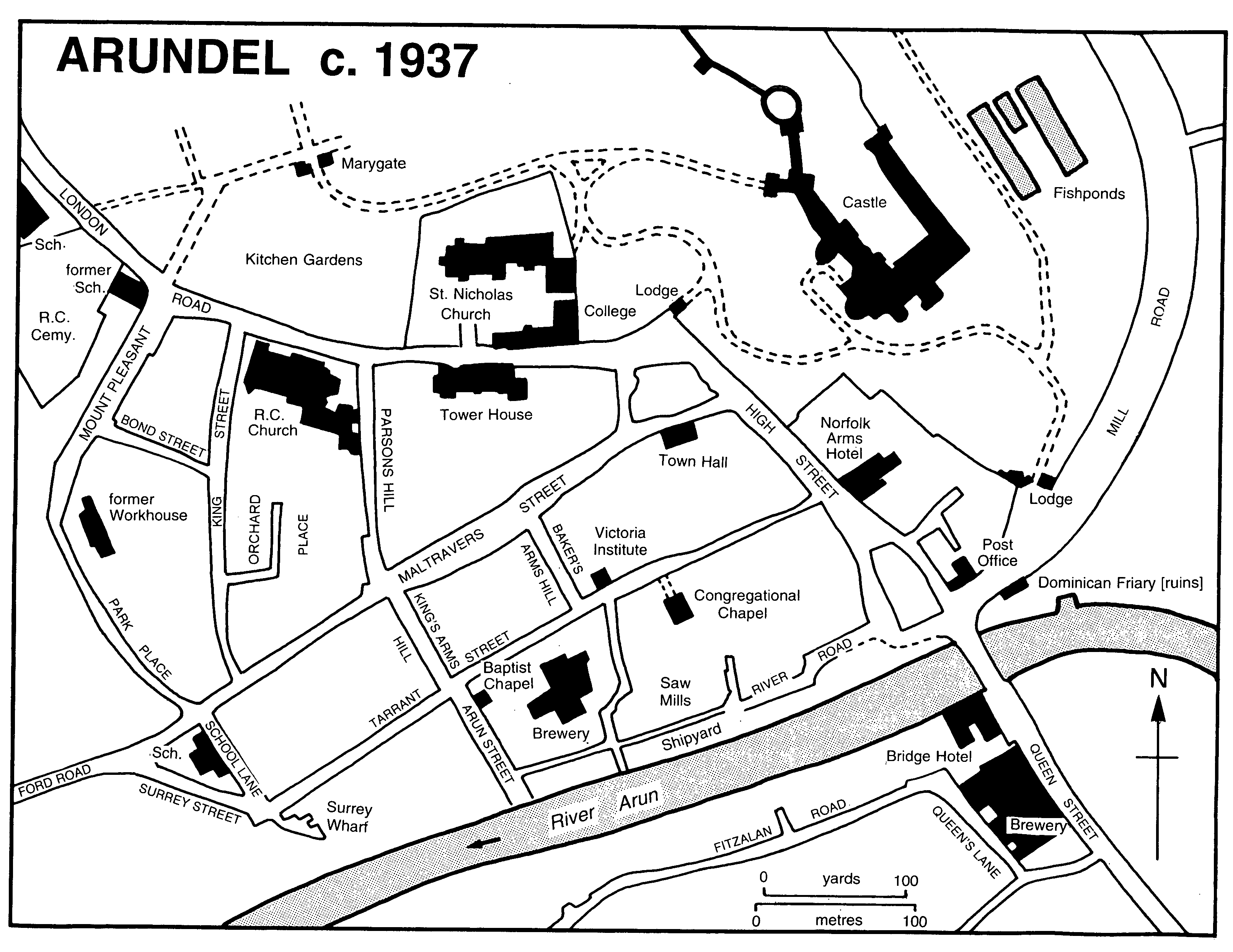
ARUNDEL c. 1937
Arundel's chief expansion in the early 20th century, however, was south of Chichester Road in what before 1902 was part of Tortington parish. Red or brown brick terrace houses, some belonging to the Norfolk estate, were built in Ford Road and Wood View by 1896 and in Kirdford Road by 1910. (fn. 265) The higher-lying land to the west around Torton Hill Road was developed by the town council from c. 1913 as an estate chiefly of large detached houses in various styles. (fn. 266)
In the mid 20th century High Street continued to be the chief shopping and business street, with smaller shops in Tarrant Street and elsewhere, Tarrant Street after c. 1980 having arcades or closes of shops occupying some former commercial or industrial premises. Maltravers Street remained largely in residential or professional use; in 1947 guest houses were apparently becoming common there, (fn. 267) but in 1988 even the biggest houses were still mostly in single domestic occupation. Tower House in London Road, on the other hand, was converted into flats in 1984. (fn. 268) The River Road area was earmarked after 1945 for light industry, (fn. 269) but by 1972 an industrial estate had opened on the south side of the river, (fn. 270) and concurrently firms in or near Tarrant Street and River Road began to close or move away. By 1990 only one factory was left there, many former industrial or commercial buildings later being converted as dwellings or replaced by new houses and flats, usually in vernacular styles. Beyond the bridge by the 1980s there were some larger shops in Queen Street. Further houses and bungalows were built after 1945, (fn. 271) some being destroyed when Fitzalan Road was cut in two by the town relief road of 1973.
The west end of the town also continued to grow in the mid 20th century. Houses for the Norfolk estate had been erected near the sawmill c. 1909, (fn. 272) and more were put up near the castle stables in the 1950s and south-west of London Road at about the same date. (fn. 273) Between Torton Hill and Chichester roads many dwellings, including some council houses, were built from the 1950s; (fn. 274) by 1991 the area south of Chichester Road had become twice as populous as the older part of the town. (fn. 275)
STREET NAMES.
Of the town's streets High Street was so called c. 1216; (fn. 276) its lower portion may have been the Wide Street mentioned in the early 15th century. (fn. 277) Alternative names were High Market Street, recorded from 1658, (fn. 278) New Market Street, used in the later 18th century, (fn. 279) and possibly Market Street, mentioned in 1570 and later. (fn. 280) Maltravers Street was apparently Old Chipping (i.e. Market) Street in the early 15th century, (fn. 281) and was generally Old Market Street between the 16th and 18th centuries; (fn. 282) the modern name has not been found before the 1830s, (fn. 283) the old name being occasionally used later. (fn. 284) The junction of High Street and Maltravers Street was called Warningcamp corner by 1601, (fn. 285) either from property nearby belonging to Byworth and Warningcamp manor, (fn. 286) or from the surname of a property owner or tenant. (fn. 287)
Tarrant Street was so named in the early 15th century, (fn. 288) and from the mid 18th was also the lower lane. (fn. 289) Mill Lane, the old road to South Stoke, was so called in 1379; (fn. 290) its alternative name Jury Lane, recorded from 1570, (fn. 291) may allude to a medieval Jewish quarter. (fn. 292) The junction of Mill Lane and High Street was called Lasseter's corner by 1851, (fn. 293) after the watchmaker whose shop was there. (fn. 294)
Other streets in the town have also had multiple names. King Street, recorded from 1636, (fn. 295) may have been the Kings Lane mentioned in 1525 and later; (fn. 296) in 1785 it was Panets Pond Lane, (fn. 297) and it may have been Punetts Lane recorded in 1574. (fn. 298) Parson's Hill, so called by the 1870s, (fn. 299) was previously Ibbetsons Lane, commemorating a property occupier of that surname; (fn. 300) it was also Farmers Lane in 1785 (fn. 301) and Parsonage Hill in 1879. (fn. 302) The street which marks the western edge of the town, formerly known as Whitings dyke, (fn. 303) was called Poorhouse Hill or Lane in the late 18th century and later; (fn. 304) by 1875 its lower part was Park Place (fn. 305) and by 1889 apparently its upper part Mount Pleasant. (fn. 306) School Lane was apparently Pottmans Ware Lane in 1636. (fn. 307) London Road was so called by the 1830s, (fn. 308) but was alternatively New Road in 1874–5. (fn. 309) The central part of River Road was called the Shipyard in 1660 and later. (fn. 310) Bakers Arms Hill was Short Lane in 1785 (fn. 311) and Baker Hill in 1874–5; (fn. 312) Brewery Hill was Brewhouse Hill in 1872 (fn. 313) and evidently the Short Lane mentioned in 1805. (fn. 314) The road beyond the bridge was described as Arundel causeway in 1660, (fn. 315) and later as the causeway between Arundel and Lyminster. (fn. 316) Its west part was Bridge Street or Queen Street in 1830, (fn. 317) and the east part Brighton Road c. 1832 (fn. 318) and Station Road by 1896. (fn. 319)
Lost or unidentified streets were Potente Street (recorded 1311), (fn. 320) Dede, Dide, or Dyde Street (early 15th century), (fn. 321) Jennet Lane (1570 and later), (fn. 322) Mincing Lane south of Tarrant Street (1686), (fn. 323) and Puttock's Hill north of Tarrant Street (1875). (fn. 324) Postern Lane near Hermitage Lane (recorded 1615 and later) and Slutters Lane nearby (1636) evidently lay beyond the Marygate. (fn. 325)
Rural settlement.
Outside the town there was never much settlement in the Middle Ages or later, apart from the water mill at Swanbourne, (fn. 326) replaced in the mid 19th century by the castle dairy, windmills and a malthouse by the river in the 19th and 20th centuries, and lodges in the successive parks of the parish. At the conversion of the Great park into a farm in the mid 18th century a farmhouse was built in Park bottom. Apparently at the end of the century it was replaced by Park House, which was demolished after 1824; (fn. 327) a flint terrace of estate cottages was put up on its site before c. 1841 (fn. 328) and survived in 1986. The farmhouse moved in the later 18th century to the modern Park Farmhouse further west. A row of what were apparently farm cottages, called Rooks buildings, was put up south of Chichester Road by 1842; (fn. 329) one single-storeyed cottage survived in 1986. Further cottages east and west of Park Farmhouse were built later in the 19th century.
SECULAR BUILDINGS.
Surviving late medieval secular buildings in High Street are nos. 37–41 (the former Crown inn), including a range parallel with the street much altered later, (fn. 330) and no. 71 (Sefton House), a Wealden house with a small hall. On the corner of High Street and Maltravers Street was a big medieval house jettied on both frontages which was demolished in the later 19th century. (fn. 331) No. 8 Maltravers Street nearby is part of a late medieval threebayed hall house with crown-post roof, while no. 79 at the west end of the same street has evidence of a crown-post roof mostly destroyed. There was a late medieval house at the west end of Tarrant Street on part of the site of the Roman villa, (fn. 332) and a timber-framed house, apparently jettied and perhaps medieval, facing the west front of the church. (fn. 333)
There are many 16th- and 17th-century houses in the town. No. 51 High Street has late 16thcentury timber-framed ranges along High and Tarrant streets; the angle between was filled in the earlier 17th century by a new block whose ground-floor room has an elaborately moulded plaster ceiling; both that room and the one above retain much original panelling. No. 26 High Street is a notable house of c. 1600 with panelling of early 17th-century style, apparently ex situ, in one back room; there is identical panelling in the front room of no. 33 High Street, which is jettied. No. 12 High Street was perhaps also originally jettied, as was a large house now demolished on the east side of the street opposite Maltravers Street. (fn. 334) In the island of buildings between the market place and the river the low no. 25 High Street on the west side, of timber framing with brick nogging, is 17th-century or earlier, while nos. 17 and 19 on the north side, of the late 17th century, are faced with painted brick. A hip-roofed and timber-framed 16th- or 17th-century house with a large chimneystack stood beside the bridge until the early 20th century. (fn. 335)
Sixteenth- or 17th-century houses in Maltravers Street include the timber-framed Little House on the corner of Bakers Arms Hill and the low adjacent brick terrace; two substantial 17thcentury or earlier buildings east of no. 14 (fn. 336) were destroyed in the later 19th century. In Tarrant Street surviving timber-framed houses of the period include the low nos. 13 and 15, faced partly in weatherboarding and partly in painted brick, and no. 21, which is jettied. (fn. 337) A timberframed, hip-roofed house on the south side of the street demolished c. 1900 was 17th-century or earlier, (fn. 338) while the Quaker meeting house on the corner of Tarrant and Arun streets, demolished in 1867, was a tall range, apparently flintor rubble-faced, with a doorway of 16th-century character. (fn. 339)
A much larger demolished building apparently of the 16th or early 17th century was the house called Nineveh at the east end of Tarrant Street. (fn. 340) It was roughly square in plan, faced with flint with stone dressings and stone mullioned windows, and had a massive brick chimneystack. The street frontage was probably occupied from the first by shops, for the two entrances in the early 19th century were a brick arched side doorway in Gothic style and a large porch on the south or river front, both then leading to a large hall which contained a staircase with big newel posts and elaborately carved balusters. There were four or five other rooms on the ground floor, besides cellars in the sloping ground. The chief room seems to have been upstairs; it had moulded oak panelling, two bay windows, and a large open fireplace containing a chimneypiece of Sussex marble with a carved wooden overmantel. The builder of the house is unknown; despite the presence in it of allusions to the heraldry of the earls of Arundel, it seems less likely to have belonged to them than to be the town house of some other important local family. The name Nineveh is recorded, as 'Ninivy', from 1718 and may be a cryptic biblical reference to the house's size. (fn. 341) In 1718 part at least of the building was the Star inn, but by the early 19th century it was in multiple occupation as dwellings and workshops. The building was demolished after 1833, (fn. 342) part of the site being later occupied by the Congregational chapel.
Two 17th-century timber-framed houses remain in Queen Street south of the bridge: the low no. 10, faced with red brick, and no. 20, which lies back from the street and is rendered. The White Hart inn, also in Queen Street, demolished in the later 19th century, was an apparently jettied building of the 16th century or earlier. (fn. 343)
During the early and mid 18th century several houses in the town were refronted in brick, for instance nos. 37–41 and 71 High Street and nos. 8 and 79 Maltravers Street; the encroachment on the street which often accompanied refronting was opposed in vain by the corporation in 1766. (fn. 344) New houses were also built during the period. The former George inn, nos. 30–4 High Street, which incorporates an earlier brick chimneystack at its north end, is a three-storeyed red brick building with rusticated brick quoins, Venetian windows, and some 18th-century internal fittings. It seems likely to have had a central archway to the inn yard, later converted to the shop front of no. 32; the shop fronts of nos. 30 and 34 are late 18th- and early 19th-century respectively. The back range of nos. 55–7 High Street is a three-storeyed red brick structure of mid 18th-century date with an original staircase, while no. 61, also of three storeys, the residence in the 1780s of the lawyer Edward Carleton, (fn. 345) has a simple 18th-century staircase and late 18th-century decoration in some rooms. In the island of buildings between the market place and the river are two three-storeyed houses of the mid or late 18th century: no. 1 High Street facing the river, of red brick formerly stuccoed, and no. 11 on the east side, of whitewashed brick.
In Maltravers Street nos. 14 and 16 are basically early 18th-century and mid or late 18th-century respectively. Three other mid 18th-century houses in the same street are grander. No. 51, the residence in the 1780s of the timber merchant John Bull, (fn. 346) is a detached three-bayed house with a red and grey brick front, the central bay being pedimented; it has some original internal fittings, and was enlarged at the back in the early 19th century. There is a contemporary detached coach house and stable in Kings Arms Hill. No. 26, the house of John Shaft, grocer and tallow chandler, in the 1780s (fn. 347) which became the vicarage in the mid 20th century, has an impressive brick front with original two-storeyed canted bay windows and a later porch. (fn. 348) The interior is fitted to a high standard with plaster cornices and much original joinery; the staircase has original carved tread ends, but its newel posts and fret in Chinese Chippendale style do not match them, and were apparently brought from elsewhere. A contemporary coach house and stable adjoin. Nos. 50–4 Maltravers Street, the residence in the 1780s of the coal merchant George Lane, (fn. 349) comprise a mid or late 18thcentury building of two and a half storeys and three bays, which was enlarged in the early 19th century at the sides and rear, with overarched Venetian windows in the side bays. The side facade of the west wing has a Portland stone depressed-arched doorway with 'Gibbsian' rusticated quoins, and two Portland stone keystones; the type of stone is unusual for Arundel, and they may be fragments from the early 18th-century work at the castle, removed during rebuilding c. 1800.
In minor streets, no. 2 Bakers Arms Hill, of the early 18th century, has a facade with elaborately moulded brick window cornices surprising in such a small building, while no. 24 River Road, of grey brick with red brick dressings and rubbed brick voussoirs, is very lavish for its position. There are also 18th-century brick or flint houses and cottages in less important areas of the town: Arun Street, Park Place and Mount Pleasant on the west edge, and Queen Street south of the river; in Park Place is an 18th- or early 19th-century coach house possibly for a house in Maltravers Street.
Many large red brick houses in the town of the late 18th and early 19th centuries share common features: a weak cornice formed by a single course of brick modillions, a terrace plan with toplit staircase across the building between front and rear rooms, and a slim unbroken baluster rail, usually of mahogany.
The grandest are in Maltravers Street. (fn. 350) No. 13 (Duff House) at the east end, is a three-bayed, two-storeyed building, originally detached; a brick on the rear façade has a date in the 1780s, when the merchant Joseph Coote lived there. (fn. 351) There is 18th-century decoration on the first floor, but the ground floor was refitted c. 1815, when the two main rooms were interconnected by double doors. No. 15, of three much taller storeys, was built on to no. 13 apparently in the 1790s; (fn. 352) a dining room with a low coved ceiling and other 'Soanian' decoration was added on the west side c. 1825, and the porch is 20th-century. (fn. 353) There is a contemporary stable and coach house adjoining, and the garden preserves its original extent downhill to Tarrant Street. Further west nos. 53–61 form a continuous terrace of two or three storeys with a basement. Nos. 55–7, which externally seem a single house, were built c. 1780 for two members of the Digance family, both merchants. (fn. 354) No. 55 has a good front room on the first floor and a large back room on the ground floor with a fine Adam-style entablature and a boarded dado with elaborate top moulding; a new wide entrance hall was added on the east in the early 19th century, the old hall being thrown into the front room. Nos. 59–61 are also a pair: no. 59, the smaller, has a big first-floor front room with fine late 18th-century decoration including an Adam-style entablature, while no. 61 has a very large first-floor room across its whole frontage and a fine square staircase hall with pyramidal skylight. (fn. 355)
Nos. 45–9 and 49A Maltravers Street, also on the south side, are an early 19th-century (fn. 356) stuccoed terrace of three storeys and basement with a prominent continuous cornice; nos. 49 and 49A were refitted internally in the mid or late 19th century, when a two-storeyed tiled iron veranda and bow windows were added at the back. No. 18 Maltravers Street on the north side is also stuccoed, with a segmentally bowed window on the ground floor; built between 1833 and 1847, it occupies the site of one of Arundel's theatres. (fn. 357)
The tall front range of nos. 55–7 High Street, of the late 18th century, is of local yellow brick with stone dressings; in the 1780s it was the residence of the mercer, later banker, Charles Bushby. (fn. 358) Almost opposite, the imposing red brick Norfolk Arms hotel was built by the duke of Norfolk between 1782 and 1785, (fn. 359) its most striking feature being the large-scale lettering of its name added in the early 19th century over the central archway to the yard. The early 19th-century no. 67 High Street has various internal fittings brought from elsewhere, including a coffered ceiling in Italian 16th-century style.
Tarrant Street between 1785 and 1788 acquired at its western end a group of mainly threestoreyed red brick houses; (fn. 360) no. 42 has a fine porch, while no. 54 has an original coach house and stable on the west, and a business office added later between with a separate entrance. New buildings built elsewhere in the town in the early 19th century were generally humbler. At the north-west end there are plain two-storeyed terraces mostly of flint or beach pebbles with brick dressings, some whitewashed, in King and Bond streets, Orchard Place, and Mount Pleasant. Other contemporary terraces of cottages are nos. 8–18 Arun Street, of galletted flint with yellow brick dressings, nos. 7–25 Surrey Street, of Plymouth stone (fn. 361) with yellow brick dressings and dated 1821, and the mid 19th-century stuccoed nos. 74–84 Maltravers Street. (fn. 362)
Some 19th-century public buildings in the town were in classical style: the Bridge hotel in Queen Street, (fn. 363) the corn store on the town quay, (fn. 364) and the Victoria institute in Tarrant Street, built in the 1840s or 50s as the Arundel savings bank, (fn. 365) which has 'Egyptian'-style window surrounds. The Swan hotel was rebuilt in the mid 19th century in Italianate style. By far the more common style for new buildings in the town after that period was revived medieval or Tudor. Two earlier examples were Tower House in London Road built c. 1795 (fn. 366) and the new town hall in Maltravers Street of 1834–5. (fn. 367) Tower House is a pair of tall semidetached villas of yellow stock brick with ashlar dressings, asymmetrical in plan with a polygonal stone tower at the east end. Its castellated Gothic style, which can be compared to that of the contemporary work on the castle and was evidently meant to match it, seems to have been due to the duke of Norfolk, and was dubbed by a visitor in 1803 the 'Arundelian order of architecture'. Further examples in the town alluded to then and later (fn. 368) evidently included the restored Marygate and college buildings, and buildings in the castle grounds and park. The town hall, designed by Robert Abraham, (fn. 369) is in a gloomy Norman style, evidently also intended to pay homage to the castle, and echoed in the same architect's Congregational chapel in Tarrant Street and in the contemporary pumping house at Swanbourne lake. (fn. 370)
Medieval- or Tudor-style buildings put up between the mid 19th century and the earlier 20th are more picturesque. A pair of Norfolk estate cottages in Maltravers Street of 1849 are in Tudor style, in red and grey brick with decorated bargeboards; the brick and stone façade of no. 38, the former custom house, is similar. (fn. 371) Nos. 40–4 Maltravers Street of c. 1883, designed by J. A. Hansom, (fn. 372) are also of red brick and stone with a prominent first-floor corner statue in a niche of Duke Henry's patron saint, the Emperor Henry II. Also perhaps by Hansom, and with some half-timbering, are nos. 66–70 Maltravers Street, at the west end, and a building on the corner of Maltravers and High streets, whose first floor is jettied on both frontages like that of its medieval predecessor.
The north-west part of the town, largely belonging to the Norfolk estate, acquired several comparable buildings from the 1860s, notably Hansom's French Gothic Roman Catholic church of 1869–73 and its attached presbytery. The Catholic boys' school, later St. Mary's hall, on the corner of London Road and Mount Pleasant, is also by Hansom, and has a prominent corner statue under a canopy of the Virgin and Child. (fn. 373) In Bond Street is a terrace of red brick and sandstone estate cottages dated 1868, enlivened by projecting porches and dormer windows with bargeboards, and raised on a brick platform. Other Tudor-style estate cottages of c. 1870 in London Road also have tall chimneystacks.
Four striking buildings in historical styles were put up at the lower end of the town in the 1890s and early 1900s. Nos. 18–20 High Street, dated 1890, is of red brick and stone with flushwork and diaper patterning, one of its six gables carrying a stone anvil emblematic of the ironmonger's shop below. Lloyds Bank next door, built before 1893, (fn. 374) is in Norman Shavian halftimbered style with tall chimneys, a dormer window, and another prominent gable. The post office building of c. 1895, by the Norfolk estate architect W. Heveningham, (fn. 375) with a red brick ground floor and half-timbered, many-gabled upper floor, acts as a frontispiece to the town when approached from the south-east, leading the eye up to the castle on the skyline. Still more picturesque are the new offices of the West Sussex Gazette built in 1899–1900 to the designs of Wheeler and Lodge of London, and then described as probably 'the most artistic newspaper office ... in England'. (fn. 376) The elaborately detailed façade of three storeys with a gable uses glass, pebbledash, and limestone ashlar as well as brick and timber, and the south side is crowned by six attached chimneys of hexagonal plan. The printing works of 1906 at the rear, with an ornate façade on Tarrant Street, is by the same firm of architects. (fn. 377)
OUTSIDE THE TOWN.
Park House or Arundel Park, (fn. 378) in Park bottom west of the town, may have existed by the mid 1790s. The home of Lord Henry Howard-Molyneux-Howard (d. 1824), brother of Duke Bernard Edward (d. 1842), (fn. 379) it was of nine bays and two storeys; (fn. 380) it was demolished after his death. (fn. 381) The grounds of the house included an oblong lake and specimen trees. (fn. 382) A pair of stone lodges on Chichester Road, built by 1804, (fn. 383) survived in 1995.
Park Farmhouse further west is chiefly late 18th- or early 19th-century, with a three-bayed classical west front of knapped flint with yellow brick dressings; the building is otherwise mostly of flint rubble. A chimneystack, together with some window frames and a stone moulding on the east front, perhaps re-used, survive from an earlier building, which was presumably a lodge in the park; some internal doorcases, however, seem grander than would be expected in a lodge, and may be 18th-century work from the castle, removed at its remodelling in the later 18th century or early 19th. The north front, in contrast to the west, is in asymmetrical Gothic style with a two-storeyed stone bay window apparently intended as an 'eyecatcher'; the front is not 16th-century (fn. 384) and may have been designed by Duke Charles (d. 1815). (fn. 385) Model farm buildings were added to the east in the mid 19th century, including a large flint barn dated 1837 and a piggery built in 1845. (fn. 386) There is also an octagonal horse gin.
DEFENCES.
As the first defensible site inland from the Arun estuary Arundel is likely to have had fortifications of some sort from an early period. Part of a curved earthwork which survives north-west of the north bailey of the castle may represent a fortification preceding that, perhaps prehistoric in date.
The Little park (the present castle cricket ground) north-west of the castle is bounded on its north, west, and south sides by linear earthworks. That on the north, of impressive size, was continued south-westwards in the mid 17th century on a much slighter scale; (fn. 387) the earthwork as a whole, therefore, cannot be a prehistoric attempt to defend the chalk promontory on which the town lies, as suggested by Tierney. (fn. 388)
The Little park earthworks may have been constructed to contain the putative late AngloSaxon burh, (fn. 389) an idea perhaps corroborated by Saxo-Norman pottery found in the northern earthwork. (fn. 390) The south part of the western earthwork is missing, possibly through 19th-century landscaping of the castle grounds, while the lack of an eastern earthwork may be due to the steepness of the cliff at that point. (fn. 391) The southern earthwork seems to have been re-used as part of the later medieval town defences. (fn. 392) At the point where the northern earthwork is cut by the apparently early track descending the downs, the lower portion of which is followed by High Street, (fn. 393) are the remains of a chalk rubble and Caen stone gateway seemingly built in the late 11th century or early 12th, (fn. 394) but perhaps succeeding an earlier one. The gate was apparently the Red gate mentioned in 1570, (fn. 395) since the London road to the north was called Red Lane. (fn. 396) It still stood in part in 1851 (fn. 397) but was afterwards grassed over.
The Norman town, which seems to have lain chiefly along the track mentioned both inside and outside the Little park, (fn. 398) probably had no defences until the late 13th century, the north gateway being then perhaps used less for defence than for collecting tolls. In 1295 a 10-years' grant of murage was obtained for the town by the earl of Arundel. (fn. 399) The line of defences created was apparently new and excluded the Little park, the north-westwards continuation of High Street being diverted. Starting from what was apparently a new gate (fn. 400) by the outer ditch of the north bailey of the castle the circuit ran west to a second gate, the Marygate, built across the new London road; the earthwork between the two gates may be the re-used southern defence of the putative Anglo-Saxon burh, turned to face outwards instead of inwards, and provided with a ditch on the north side which survived in 1995. From the Marygate the line of the new defences ran south-west, first within the modern castle grounds, and then down Mount Pleasant, Park Place, and School Lane, where a natural cliff was scarped back. (fn. 401) Mount Pleasant was known by 1615 as Whitings dyke, (fn. 402) possibly from a personal name. A section of earthwork was said to be still visible by the St. Mary's Gate inn in London Road in 1851. (fn. 403) At the point where the circuit crossed Maltravers Street was a third gate called the Marshgate or Watergate. (fn. 404)
The medieval defences seem only ever to have been of earth, as also happened in some larger medieval towns. (fn. 405) It is notable that they protected only the north and west sides of the town. The south side would have been defended by the river, though nothing is known of any gate on the bridge. The sector between the bridge and the castle was undefended, the terrain perhaps making it unnecessary. References to 'the new ditch' in or near Tarrant Street in the early 15th century (fn. 406) may suggest either that the south end of the western line of defence was not completed until then, or that it was extended at that date nearer the river.
It is not clear which gate was referred to in 1321, when packing service was owed at Ham manor in Angmering 'beyond the gate of Arundel'. (fn. 407) The Marygate probably existed in 1343, when a chapel, apparently dedicated to St. Mary, was said to have been newly founded at the north gate of the town. (fn. 408) The name Marygate was in use by the early 15th century. (fn. 409) The medieval building is said to have been of ashlar masonry. Besides the chapel over the archway, which had a two-light cusped window and was reached by an external flight of steps, there was a room each side on the ground floor. (fn. 410) Part of the gate at least had apparently been converted into a dwelling by 1636, (fn. 411) and the structure was certainly used as dwellings later. (fn. 412) Only the side piers of the gate next to the north bailey ditch remained in 1781, (fn. 413) and only the ivy-covered stump of its east pier, of flint and stone, by 1989. The Marshgate or Watergate is recorded only between 1615 (fn. 414) and 1712 (fn. 415) and had been demolished by 1785. (fn. 416) A postern gate near the Marygate is indicated by the road name Postern Lane recorded in the area in the early 17th century. (fn. 417)
The town defences were strengthened in December 1643 by Ralph Hopton, Lord Hopton, after his capture of the town for Charles I. (fn. 418) A south-westwards continuation of the northern earthwork of the Little park down to Park bottom prevented access from the west; the portion of Hopton's work which survives on either side of London Road and which was later known as Roads ditch, possibly from a personal name, (fn. 419) is distinguished from the northern earthwork of the park by its much slighter scale. (fn. 420) At the same time the latter was apparently heightened and its ditch deepened. Hopton also threw up a double earthwork north of the town near Swanbourne lake in order to cut off a possible approach by way of Mill Lane under the east side of the castle. That seems to be the ditch and banks of which there are traces on the steep hill between the lake and the north-east corner of the Little park. (fn. 421) When Sir William Waller returned to retake the town for Parliament soon afterwards he broke through both lines of defence, those on the west withstanding his assault for two hours. (fn. 422) The circular mounds at each end of the northern earthwork of the Little park (fn. 423) may be gun emplacements created thereafter to command the castle.
After Waller's capture of the town and castle in January 1644 the fortifications of the town may again have been strengthened. In 1653, however, the castle was slighted, (fn. 424) and six years later the town defences were ordered to be 'thoroughly' demolished. (fn. 425)
The Marygate may have been damaged in the Civil War, for lead was removed from the roof, apparently by the mayor, before 1652. (fn. 426) The upper storey survived in the 1720s, (fn. 427) but by 1780 the arch had been taken down as dangerous to users of the London road, (fn. 428) apparently the chief means of approach to the town by land. (fn. 429) By 1809 the duke of Norfolk had acquired the remains of the gate (fn. 430) and before 1815 he restored it in medieval style. (fn. 431) Part of the original structure remains on the south side west of the archway, but the present building is mostly 19th-century and later; it is of flint with sandstone dressings, including some flushwork, and has battlements and machicolations on both faces. The portion of wall west of the gate was built of Plymouth rock shortly before 1817. (fn. 432) The gate was again restored in the early 20th century, when an external staircase to the upper floor was built on the south side. (fn. 433) The ceiling of the upstairs room has four massive oak timbers with 16th-century-style heraldic decoration which partly relates to the FitzAlan family. (fn. 434) Evidently too large and too much weathered to have been part of an interior decorative ensemble, they may be timbers from a drawbridge. (fn. 435)
The landscaping of the castle grounds in the early 19th century apparently included major alterations to the Little park earthworks, which in 1819 had been said to be still complete. (fn. 436) The bank east of the Marygate was levelled and turned into two terraces apparently by 1825, (fn. 437) while its east end seems to have been pushed into the ditch to give a link and a level vista to the park from the section of the grounds nearer the castle. The south part of the park's western earthwork may have been removed at the same date.
RELIGIOUS HOUSES.
Arundel was the site of seven medieval religious houses; five at least were under the patronage of successive lords of the rape, as were two others nearby, Pynham priory in Lyminster and Tortington priory. (fn. 438)
The histories of the apparently pre-Conquest minster church, the Norman priory, and the college which succeeded it in the later 14th century are treated below. (fn. 439)
College buildings.
The buildings of the college perhaps occupied the same site as those of the priory, and are architecturally en suite with the new parish church of the same date. The Fitzalan chapel of the parish church formed the college's north side, and there were two-storeyed east, south and west ranges; the east range lies beyond the east end of the Fitzalan chapel, and the outer wall of the west range is aligned with the east wall of the south transept of the church. The entrance gateway was apparently at the south-west corner, (fn. 440) on the same site as the present 19th-century entrance, and the master's house is said to have been in the north-east corner, a small gallery giving access to the Fitzalan chapel behind its high altar. (fn. 441) There was a cloister along the northern section of the east range and also along the wall of the Fitzalan chapel; (fn. 442) part survived in 1989.
Since the area enclosed by the three ranges and the chapel is very large, it may originally have been divided into separate north and south courtyards, as at the slightly earlier college at Cobham (Kent). (fn. 443) If so, the northern courtyard may have had a cloister all round, and the hall mentioned in 1382 (fn. 444) may have lain in the cross range between the courtyards, as at Cobham. A chapter house was mentioned in 1401. (fn. 445) It is not clear whether there was a college graveyard separate from the parish churchyard.
In 1644 the east and south ranges of the college were depicted as complete. (fn. 446) A visitor in 1635 had mentioned the cloister and gardens, and 'a fair long building' nearby, perhaps the hall, in which quarter sessions were then held, and at the end of which was a low round tower of stone with a conical top, apparently a former calefactory. (fn. 447) At that time part of the buildings at least was let, presumably as a dwelling. (fn. 448) The college was apparently damaged during the Civil War, for stone and timber were removed from it for re-use elsewhere in 1657–8. (fn. 449) Repairs were carried out between 1659 and 1664 (fn. 450) and c. 1678. (fn. 451) In the mid 18th century the buildings were described by two separate visitors as merely remains, (fn. 452) and in 1780 the east and west ranges seem to have survived in parts of their outer walls only. (fn. 453) There were some structures inside the shell of the south range in 1788. (fn. 454)
The north-east corner of the quadrangle, on the other hand, had been rebuilt or restored during the 18th century as a residence for the duke of Norfolk's agent. (fn. 455) In the 1780s that building consisted of a west range running north-south, with a canted bay under its north gable, and an east range running east–west with an 18th-century porch on the north side. (fn. 456) Between 1804 (fn. 457) and 1815 (fn. 458) the building was rebuilt in Gothic style and about that time it housed a private school. (fn. 459)
In the late 18th or early 19th century, apparently by 1797, (fn. 460) Duke Charles (d. 1815) restored the south range of the college, its west end becoming a Roman Catholic chapel, with the chaplain's residence and other dwellings further east; (fn. 461) a terrace was constructed on the south side above the new London road. Some contemporary fittings remained in that range in 1989. The late 18th- or early 19th-century work was in grey Plymouth stone, (fn. 462) in contrast to the flint and stone with sandstone dressings of the original work; the walls were crenellated, a practice continued in later 19th- and 20th-century alterations. (fn. 463) In 1834 the external walls of the unrestored east and west ranges retained many, if not most, of their original trefoil-headed windows. (fn. 464) The Catholic chapel was lengthened westwards in 1865, but ceased to be used after the new Catholic church was opened in 1873. (fn. 465)
By 1842 part of the east range was used as a laundry for the castle, (fn. 466) as later. (fn. 467) In the 1850s the south-east corner of the college was converted into a convent, (fn. 468) as it remained until the 1950s. (fn. 469) At the same period the appearance of the north side of the courtyard was spoilt by the building of the funerary chapel of Duke Henry Granville (d. 1860), which projects from the south side of the Fitzalan chapel. Between the mid 1870s (fn. 470) and the 1890s (fn. 471) the west part of the south range and a new west range were used for a girls' and infants' school; a girls' club occupied part of those premises in 1899, and they were added to the convent in 1903–4, when further alterations and repairs were carried out. (fn. 472) The 19th-century west range was later removed, leaving the west wall to stand alone.
Between c. 1961 and 1974 the college buildings were used as a children's home with 30 inmates, and after 1976 the south range and part of the east range were converted as an old people's home and the north-east corner was divided into flats for the elderly, both run by the Order of Malta Homes Trust. (fn. 473) The former Catholic chapel was converted in 1976–7 for use as a theatre, (fn. 474) the early 19th-century west gallery and flat ceiling in Gothic style remaining, the former ex situ.
Dominican friary.
The Dominican friary founded in Arundel by 1253 (fn. 475) has been said since 1834, on the basis of oral tradition, to have occupied a site on the east or west corner of Maltravers Street and Parson's Hill; (fn. 476) Hollar's view of Arundel of 1644 shows a church apparently there with a tower and low spire like those of the parish church. (fn. 477)
Hollar's view of the town, however, is untrustworthy in other details, (fn. 478) and it is more likely that the second church in it was added simply for artistic effect. It is clear from other evidence that the friary occupied the buildings beside the bridge hitherto identified with Holy Trinity hospital (the Maison Dieu). In 1619–20 reference was made to the building of a pier or jetty at the north side of the bridge next to the Friars, (fn. 479) and two drawings of the buildings by Grimm are captioned 'the friary chapel'. (fn. 480) A body was said to have been washed ashore at 'Fryers' within the borough in 1543, (fn. 481) which corroborates a riverside site, as does mention of a boathouse beside the friary in the late 14th century. (fn. 482) A close next to the former friary in the 16th or 17th century was called Friars meadow. (fn. 483)
Further, though the buildings of the 'Maison Dieu' themselves lack dating evidence, except for a possibly 14th-century doorway in the demolished west range, (fn. 484) finds made during partial excavation of the site in the 1960s included 13thand early 14th-century material. (fn. 485) The prominent site by the bridge, the port, and the market would be much more appropriate to a preaching order than to a hospital. Moreover, the scale of the buildings is not incommensurate with the friary, which though it was poor by 1402 (fn. 486) and remained so at the Dissolution, when there were only five inmates, had earlier had perhaps 20 or 22. (fn. 487) In the mid 19th century interments were said to be still traceable in what was presumed to be a former cemetery nearby. (fn. 488)
The buildings of the friary, formerly known as the Maison Dieu, may have consisted of north, south, and west ranges round a courtyard; (fn. 489) no east range is known, and the east side of the courtyard may have been open. In the 17th century part of the site at least was apparently let as a dwelling, and repairs were mentioned in 1659. (fn. 490) The two-storeyed south range, which survived in 1995 between Mill Road and the river, had been gutted by 1780, when only its east wall, with a large window, survived above ground-floor level. At that date it was used as a timber yard, (fn. 491) as it continued to be in the mid 19th century. (fn. 492) The range is of flint and clunch with sandstone dressings, the north wall showing evidence of a cloister on its north face. The west range, also of two storeys, may have been the dormitory; (fn. 493) an arched doorway in its west wall was possibly 14th-century, (fn. 494) and there was a large three-light window in the north wall of its upper storey. (fn. 495) By 1780 the range had become a malthouse, (fn. 496) as it remained in 1851; (fn. 497) most of it was destroyed apparently in the later 19th century, (fn. 498) and what remained of the north wall collapsed in a gale in 1965. (fn. 499) The north range was apparently already in ruins by 1780; (fn. 500) part, also of flint and clunch with stone dressings, survived in 1995 behind the post office in High Street. The north range evidently contained the church, which in 1382 had both a high and a low altar. (fn. 501) Traces of a gateway between the south and west ranges are said to have been visible in 1834. (fn. 502) The surviving remains were consolidated and restored in the 1990s. (fn. 503)
Hospitals.
The hospital of St. James for female lepers recorded between 1182 and 1301 (fn. 504) was occupied by a hermit by 1435. (fn. 505) Its site was north-west of the town towards Park bottom near the pale of the Great park, (fn. 506) where ruins of the hermitage were visible in 1636 (fn. 507) and where fields called the Hermitage or Armitage remained in 1776. (fn. 508) Foundations were said to be discernible in 1834 (fn. 509) and medieval tiles and pottery were found there in the early 20th century. (fn. 510)
Since 1793 the site of Holy Trinity hospital (the Maison Dieu) founded in 1395 has been assumed to occupy the remains of buildings by the bridge; (fn. 511) but for reasons stated above those buildings rightly belong to the Dominican friary. The hospital, which was to have chapel, refectory, and dormitory, (fn. 512) was founded under the aegis of the college, (fn. 513) and could be expected to be near it and secluded, rather than half a mile away and in a prominent, public, and noisy position. Further, one of the tasks enjoined on the aged or infirm inmates was weeding the churchyard walks, (fn. 514) a difficulty if it involved climbing the length of High Street. The most likely site for the hospital is north-west of the church, where an almshouse was said to stand in 1636, (fn. 515) and where a visitor in the 1720s mentioned an 'old priory' in the process of being demolished, stone from it being used to build the new bridge. (fn. 516) The northern part of the west wall of the churchyard together with the westwards continuation of its north wall seem in their lower courses to belong to that building; they are of flint and stone, with windows and doorways of 14th- or 15th-century character, (fn. 517) and closely match the contemporary church and college in style. Within the castle car park which they partly enclose numerous human bones were excavated in the early 19th century, (fn. 518) perhaps from the chapel of the hospital.
The hospital of St. John the Baptist mentioned in 1269 (fn. 519) has not been located, and no more is heard of it.
COMMUNICATIONS. (fn. 520)
Roads.
The Roman road from Chichester to Brighton passed through the south end of the parish, apparently crossing the river Arun by a ferry between the sites of the gasworks and the railway station. (fn. 521) High Street seems to be part of another early route, running from the crest of the downs, through what later became first the Little park and afterwards the castle cricket ground, to a higher river crossing on or near the site of the modern bridge. The route later followed by Mill Lane along the west side of the river valley north of the bridge may also be early.
In the Middle Ages (fn. 522) and later (fn. 523) Arundel lay on the main road between Chichester and Lewes, part of the great route between Southampton and Canterbury. The section between Chichester and Arundel was especially important while the rapes of Arundel and Chichester were still undivided; (fn. 524) east of Arundel the road used the drier downland country via Findon and Steyning. The downland road to Steyning remained important in later times, providing an alternative route to Horsham in 1771 (fn. 525) and to London in 1775. (fn. 526) The road from Arundel to Shoreham, the modern A 27, was mentioned c. 1215 (fn. 527) and also remained important, (fn. 528) though never turnpiked. (fn. 529) South and south-east of Park Farm the gradient was apparently eased in the late 18th century or early 19th by a cutting and embankment which survived in 1986. Canada Road, south of Chichester Road, was cut c. 1813 to replace part of it (fn. 530) but never did so; it was called Green Lane in 1910. (fn. 531)
A causeway across the valley existed at a date before 1151, when Adelize, wife of William d'Aubigny, earl of Arundel, founded Pynham priory in Lyminster with the duty of maintaining it; the alternative name of the priory was de Calceto ('of the causeway'). The priory's exemption from tax in the 1340s seems to have been granted in order not to prejudice that work. (fn. 532) It is not clear whether the main channel or channels of the river were bridged by the mid 12th century as well; the description of High Street in the later 12th or early 13th century as the road leading to the ferry (apud passag') suggests not. (fn. 533) A bridge existed, however, by 1263. (fn. 534) Bridge and causeway are mentioned together in 1454, (fn. 535) and implicitly in 1568, when the bridge was described as an ancient one of timber, of great height and length. (fn. 536) The borough authorities were concerned with repair by the mid 15th century, (fn. 537) and in the early 16th income was also received from bequests. (fn. 538)
After the Dissolution the borough assumed Pynham priory's responsibility for the bridge, (fn. 539) perhaps including the rest of the causeway, and between the 16th century and the 19th the mayor generally had the additional title of bridgewarden. (fn. 540) The profits of the burgess brooks, however, were retained by the corporation for its own use. (fn. 541) The cost of bridge repair was met partly by local collections until 1568, when the corporation received licence to raise money for the purpose by the export, duty free, of 400 qr. wheat a year for five years. (fn. 542) Further collections were made c. 1593 (fn. 543) and in 1610 (fn. 544) from parishes in western Sussex, and in the early 1640s in the town and its immediate vicinity, 100 loads of timber being supplied by the earl of Arundel. (fn. 545) Money was still apparently sometimes collected in the early 19th century. (fn. 546)
Meanwhile, an application to quarter sessions in 1592 for a rate to be levied for the purpose on the three western rapes was refused, (fn. 547) and in the early 1640s the corporation was forbidden to levy a bridge rate within the borough. (fn. 548) As a quid pro quo Arundel was exempted in the 18th and 19th centuries, and perhaps earlier too, from the general rate for bridge repair within the rape, and from rates for the repair of other individual bridges in the county. (fn. 549) In 1679, nevertheless, (fn. 550) the corporation did levy a bridge rate, and in the early 19th century the poor rate met most of the cost of repair, the sum received in 1802 being £68. (fn. 551) Two additional items of income between the later 16th century and the early 20th (fn. 552) were the annuity of £2 devised in 1592 by Thomas Taylor, a former mayor, from the Crown house in High Street, presumably the Crown inn, (fn. 553) and the rent of a storehouse by the quay devised in the following year by another former mayor, Edmund Shephard. (fn. 554)
The bridge was depicted in 1644 as of wooden trestle construction. (fn. 555) It was replaced in 1724 by a.new stone bridge of three arches, paid for by a relation of one of the town's M.P.s. (fn. 556) Portland stone was used for repairs in 1784 and 1805, and the crown of the bridge was levelled in 1785. (fn. 557) In 1825 the inhabitants resolved to widen the bridge to cater for the increased traffic caused by the growth of nearby coastal resorts. (fn. 558) The work, which included levelling the approaches and adding a paved footpath on each side supported on brackets, was carried out in 1831 using surplus funds of the Arundel savings bank which the mayor and bridgewarden William Holmes later had to repay. (fn. 559)
In 1896 repairs were being financed from the town rates and a Local Government Board loan. (fn. 560) The unfairness of a small town's having to maintain a bridge for the benefit of traffic generated by much larger, and faster growing, places was finally recognized in 1900, when the new West Sussex county council agreed to pay £150, three fifths of the estimated cost of the bridge's improvement; (fn. 561) the county council, however, did not take over permanent responsibility for the bridge until 1930. (fn. 562) A new, wider, threearched bridge of reinforced concrete faced with sandstone was built in 1935, inscriptions of 1724 and 1831 being reset in it. (fn. 563)
A ferry at an unknown site was maintained by the corporation in 1609. (fn. 564)
A relief road for east—west traffic, first planned in the late 1930s, (fn. 565) was opened in 1973 (fn. 566) across the marshes south of the town; a north-westwards continuation beside Park bottom bypassed the town for London traffic too. A new bypass road further south was being planned in 1995.
The medieval road to London, as indicated above, originally passed through what was later first the Little park and afterwards the castle cricket ground. It seems to have been diverted westwards round the Little park when the latter was created apparently c. 1300, passing through the new line of defences by way of the Marygate. North of the town the road was known as Red Lane by 1636. (fn. 567) In 1675 the London road was depicted via Billingshurst, (fn. 568) but in the 18th century an alternative route ran through Petworth. (fn. 569) In the later 18th century the Arundel—London road was said to be very good. (fn. 570)
In 1757 the London road in the parish was made a turnpike, as part of a route via Bury to Guildford; (fn. 571) the work authorized had not been completed by 1778, (fn. 572) however, and in 1799 the trustees were absolved from repairing the section of road between Arundel and Newbridge in Wisborough Green. (fn. 573) The London road within the parish was afterwards diverted in two stages during the creation of the new landscaped park. In 1793 the duke of Norfolk was authorized to close the northern section and replace it by a new road already built from the north-west corner of the Little park by way of a new lodge, the Green Doors lodge, to Whiteways in Houghton on the crest of the downs. (fn. 574) The southern section was replaced in 1803 by a second new road, (fn. 575) planned from 1796, (fn. 576) which led from near the top of High Street round the south side of the church and college to a point beyond the Green Doors lodge. The two new sections of road were turnpiked between 1803 and 1881. (fn. 577) The southern part of the old road, however, remained open in 1829, when a visitor complained that the entrance through the Marygate was one of the worst town approaches in Britain. (fn. 578) The line of the medieval road was followed by a track in 1995.
Two minor roads branched off from the old London road north of the Little park. Pughdean Lane to the north-east, recorded from 1615, (fn. 579) led to Houghton by way of Pughdean bottom above Swanbourne lake. (fn. 580) On the west side Hermitage Lane, so called in 1636, (fn. 581) led to the site of the former leper hospital near Park bottom. (fn. 582) Both roads survived in the 1770s (fn. 583) but were later absorbed into the new landscaped park created after 1786. Hermitage Lane was still traceable in 1834 (fn. 584) but afterwards disappeared. The line of Pughdean Lane was marked in 1922 by a double row of old trees 400 ft. (122 metres) south of Hiorne's tower; (fn. 585) in 1988 it was followed in part by a bank.
A road to Madehurst was mentioned in 1158. (fn. 586) The track leading to Slindon along the southwest side of Rewell wood is presumably ancient, since it is followed in part by the parish boundary; (fn. 587) in 1817, however, it was overgrown and evidently ceasing to be used. (fn. 588) Queens Lane and Fitzalan Road on the east side of the river led to the windmill south of the town (fn. 589) but were unnamed until the 20th century. (fn. 590)
The street names of the town are discussed above. (fn. 591) Surrey Street joining the western ends of Tarrant and Maltravers streets was cut c. 1783 by the parish surveyors of highways across land belonging to the duke of Norfolk. (fn. 592) The New Cut between the eastern ends of Maltravers Street and London Road, so named c. 1875, (fn. 593) was made c. 1805. (fn. 594) Mill Lane, the old road northwards to Swanbourne mill and South Stoke along the edge of the river valley, was proposed for closure by the duke of Norfolk in 1850, since conversations, including offensive language, could be heard from it within the castle; a new road was to replace it across the marshes up to ⅓ mile (535 metres) east of the town. The proposal was rejected on appeal to quarter sessions by the brewer George Constable. (fn. 595) Mill Lane was eventually closed to traffic in 1894, when the wide, tree-lined Mill Road was opened, nearer the town than the replacement road of 1850. (fn. 596) The line of Mill Lane through the castle grounds could still be traced in 1987.
Carriers.
A carrier of Arundel was presented apparently for Sunday drinking in Binsted in 1626. (fn. 597) There was a carrier to London in 1657 (fn. 598) and there were two in 1681; (fn. 599) probate inventories survive for three others between 1690 and 1734. (fn. 600) In the mid 1790s a carter's wagon arrived from London twice weekly. (fn. 601) By the early 1830s there were carriers to London and Portsmouth four days a week, to Chichester, Brighton, and Bognor two days a week, and to Littlehampton daily. (fn. 602) The London carrier no longer operated in 1852, when a 'railway carrier' at the Norfolk Arms hotel was first mentioned, the service continuing until 1938 or later. By 1866 Chichester and Brighton were the only distant places to be served by carriers; the service to Brighton ceased by 1874, and that to Chichester after 1913. (fn. 603) In 1900 carriers plied between Arundel and several nearby villages at least weekly. (fn. 604)
Coaches and buses.
An Arundel coach ran to London apparently by way of Lewes in 1791; (fn. 605) in the mid 1790s there were coaches to London and back three times a week. (fn. 606) A short-lived service via Horsham was running in 1809, (fn. 607) and in 1812 the London coach went by way of Petworth. (fn. 608) About 1818 R. W. Walker of Michelgrove house in Clapham set up a rival daily coach via Dorking. (fn. 609) In the early 1830s there were six London coaches a week in winter and nine in summer; (fn. 610) in the 1840s the journey apparently took four hours. (fn. 611) Brighton and Portsmouth were served three times weekly in the mid 1790s; (fn. 612) there was a daily service to Brighton in 1812 (fn. 613) and to Portsmouth by 1817. (fn. 614) A coach to Salisbury and Bath ran via Chichester in 1809. (fn. 615) In the early 1830s there were six coaches a week to Southampton and three to Bath and Bristol. (fn. 616) London, Southampton, and Portsmouth could all still be reached daily by coach in 1845, but all coach services to and from the town ceased soon afterwards. From 1847 or earlier horse omnibuses of the railway company met each train at successive stations serving Arundel. Motor buses plied to Worthing, Brighton, Littlehampton, and Pulborough in 1907; in 1927 there were frequent services to Chichester and Horsham. (fn. 617) An express motor coach to London ran daily in 1934. (fn. 618) In 1992 there were regular buses to Littlehampton, Worthing, and Brighton, and less regular ones to Bognor Regis and elsewhere. A bus station near the bridge on the corner of River Road was built in 1954 and demolished before 1981. (fn. 619)
Railways.
The railway line from Worthing to Lyminster, with a station at Lyminster called Arundel and Littlehampton, was opened in 1846, and the line from Lyminster to Chichester later in the same year, with a station at Ford originally called Arundel. A plan of 1837 to bring the railway closer to Arundel had apparently been opposed by the duke of Norfolk. The present Mid Sussex line from Hardham junction to Ford was opened in 1863, with a new station, at first called New Arundel and later Arundel, also in Lyminster parish. It was electrified in 1938. (fn. 620) Facilities for goods traffic at Arundel were withdrawn in 1963. (fn. 621)
SOCIAL AND CULTURAL ACTIVITIES.
A theatre was built c. 1792 by the manager Henry Thornton. (fn. 622) A performance is recorded in 1801, (fn. 623) and Thomas Trotter's company played there several times in the early 19th century. (fn. 624) In 1807 Thornton built on the site later occupied by no. 18 Maltravers Street a new theatre under the duke of Norfolk's patronage; the opening performances by Master Betty were said to have drawn 'all the families of rank and taste' within 20 miles. The building was modelled on the Theatre Royal, Drury Lane, and was of brick. (fn. 625) Occasional performances took place between the 1810s and the early 1830s, She Stoops to Conquer being played in 1827, but the theatre seems to have fallen out of use c. 1835 and was pulled down soon afterwards. (fn. 626) What may have been its side walls could be seen in 1988 flanking the garden of no. 18 Maltravers Street, the seating having presumably been in the slope of the hill. (fn. 627)
In the mid 19th century the town hall was sometimes used as a theatre, again under the duke's patronage. (fn. 628) During the mid 1970s the Arundel players performed in Slindon village hall for lack of a suitable hall in Arundel, but in 1976–7 part of the former college buildings south of the church was converted as the Priory playhouse. (fn. 629)
The dramatic and musical entertainment advertised in 1797 probably took place in the theatre. (fn. 630) In 1835 there was said to be no public hall in the town, the big room over the entrance of the Norfolk Arms hotel being used instead for meetings, (fn. 631) as it was later for at least one concert. (fn. 632) After c. 1835 the new town hall was another venue for concerts, balls, and other public events. (fn. 633) A 'harmonic society' was mentioned c. 1840. (fn. 634) The Arundel town brass band flourished between the 1860s and 1890s, regularly playing in the market place and in the castle grounds during the summer, and touring several times in France; the Blackman family which ran it (fn. 635) were involved in other aspects of Arundel's musical life over three generations: the church choir from the later 19th century, a dance band, and a concert party which performed over a wide hinterland in the 20th century. (fn. 636)
About 1900 the church choristers gave an annual Christmas concert at the town hall. (fn. 637) Plans to build a church hall at the corner of Maltravers Street and Park Place, which could also serve for concerts and other entertainments, were canvassed from 1910, but the site was sold c. 1951. (fn. 638) In 1990 premises used for meetings and entertainment by groups in the town included St. Mary's hall in London Road and the premises of the Wildfowl and Wetlands Trust in South Stoke. An Arundel and District music, later choral, society was formed in 1912 and survived in 1992 as the Arun choral society. (fn. 639)
A historical pageant was held in 1923 in aid of West Sussex hospitals in the grounds of the castle. (fn. 640) An annual summer arts festival was started in 1977, with concerts, open-air plays, and other events. (fn. 641)
A lecture on astronomy was held in 1830, apparently at the theatre. (fn. 642) Besides libraries recorded below, there were various circulating libraries in the town in the 19th century, including one kept by a printer and one by the Arundel library society; (fn. 643) there were also lending libraries at the Independent Sunday school in 1833 and the National school in 1879. (fn. 644) In 1851, nevertheless, George MacDonald, the minister of the Independent chapel, regretted that at Arundel he could have no society and no books of any kind except his own. (fn. 645) A branch of the county council library service was opened at no. 51 Maltravers Street by c. 1960, (fn. 646) later moving to the former National school in Surrey Street.
Three inhabitants subscribed jointly to a London newspaper in 1778. (fn. 647) Mitchell's Monthly Advertiser and West Sussex Market and Railway Intelligencer, of independent outlook, was founded at premises in High Street in 1853 by the printer T. H. Mitchell, with his son W. W. Mitchell, later mayor, as editor and publisher. It was soon renamed the West Sussex Advertiser, and from the following year appeared weekly as the West Sussex Advertiser and South Coast Journal, later the West Sussex Gazette and County Advertiser. Despite the smallness of the town in the 19th and 20th centuries, the paper claimed in 1903 to have the largest circulation of any provincial newspaper in southern England. (fn. 648) In 1995 it remained one of the two chief West Sussex newspapers, but though its offices were still in Arundel it was no longer printed there, ownership having passed to Portsmouth and Sunderland Newspapers. (fn. 649) A rival paper, The News (Littlehampton and Arundel), Local Guide, District Reporter and Visitors' Journal, was published in both towns between 1869 and 1880 or later. (fn. 650)
A society for mutual improvement was formed in 1835, whose 30 members, all churchgoers, subscribed 2d. a week. Lectures were given on scientific subjects and on church history, and there was a small library. The society still flourished in the 1920s. (fn. 651) An Anglican working men's club was founded by the Revd. George Arbuthnot in 1876; it occupied two rooms of a house in Mill Lane, where there were a library, open for five hours each evening, and a lecture room. Coffee was provided, and cards and billiards were played. Membership rose to over 90, but the club closed after Arbuthnot's departure in 1879. Other 'improving' societies founded by him were a coal club, a boot and shoe club, and a children's savings bank. (fn. 652) A Roman Catholic working men's club existed by 1878; in 1895, when it had over 100 members, it was in Park Place and in 1903 it was known as St. Philip's club. By 1907 there were a library, a billiard room, and a gymnasium. The club closed in the 1930s. (fn. 653) A Catholic girls' club occupied part of the former college courtyard in 1899. (fn. 654)
The Arundel co-operative industrial and provident society had 287 members in 1892. Besides stores in Tarrant Street, it ran a shoe club, a coal club, and a free library, all open for an hour each evening. (fn. 655) The Victoria institute in Tarrant Street, occupying the former savings bank premises, was opened c. 1897; in 1900 the duke of Norfolk was president and the mayor vice-president. There were a reading room, a library also used for classes and meetings, and a ladies' room; billiards, bagatelle, and other games were played. By 1907 there were c. 160 members. The institute survived in 1991 in a slightly altered form. (fn. 656)
The Norfolk centre in Mill Road, a day centre for the elderly, was given to the town in 1967 by the duke of Norfolk. (fn. 657)
A conservation society, later called the Arundel Society, was founded in 1965 (fn. 658) and flourished in 1995. A prosecuting society founded in 1796 survived in 1988 as a dining club. (fn. 659)
A programme of cinema films, perhaps open to the public, was given at the castle in 1923. (fn. 660) The Arun cinema in Queen Street, with an 'Art Deco' facade, opened in 1939; (fn. 661) it closed in 1959 (fn. 662) and was replaced by a garage.
An Arundel museum society was formed c. 1963, and a local history museum, run by the town council with the society's advice, was started in the town hall basement in 1964, when it was open two afternoons a week in summer. (fn. 663) In 1977 it moved to no. 61 High Street, leased from Arun district council, (fn. 664) and by 1995 its opening hours were much longer. Other museums which reflected Arundel's growth as a tourist centre in the 1970s and 80s were the 'museum of curiosity', formerly in Bramber, which flourished between 1974 and c. 1986, (fn. 665) and a toy museum opened in 1978. (fn. 666)
Sport.
Bowls was apparently played in Arundel in 1565. (fn. 667) A square bowling green had been laid out on a mount south of the south-east front of the castle by 1737; (fn. 668) it was restored c. 1990.
An Arundel cricket team existed in 1702, (fn. 669) but where it played is not known. The modern cricket ground south of Park Farmhouse was in use by c. 1875. (fn. 670) The Arundel cricket club mentioned in 1877 (fn. 671) still used the ground in 1980, when it claimed to have existed since c. 1775. (fn. 672) A boys' cricket club was set up in the 1870s, apparently in connexion with the National school. (fn. 673) Another ground south-east of Park Farmhouse was used from c. 1896 (fn. 674) by the Catholic St. Philip's cricket club, which apparently survived in the 1930s. (fn. 675) A third ground was created in the former Little park north-west of the castle in 1895; Duke Bernard (d. 1975) played there during most of his life, and the Arundel castle cricket club was still under the patronage of his widow in 1995. (fn. 676) Visiting national touring teams often played a game there after 1956. (fn. 677) In the mid 1980s there were over 40 games a year at the ground. (fn. 678) An indoor cricket school was opened there in 1991. (fn. 679)
Annual race meetings called Arundel races were held in July or August between 1838 and 1843; (fn. 680) the course used may have been on Park farm, where races were apparently held in 1876. (fn. 681) A summer regatta took place on the river in the years before 1914. (fn. 682)
In 1859 open-air swimming baths between Ford Road and the river south of the gasworks in Tortington were opened at the joint expense of the town council, the duke of Norfolk, and Lord Edward Howard, M.P.; they consisted of two long pools side by side for segregated swimming. They were closed in the late 1940s as a health risk (fn. 683) and by 1991 the site had been built over. A new open-air swimming pool was opened in 1960 on a site in Queen Street given by the duke of Norfolk; (fn. 684) it survived in 1995.
A football club formed in 1889 and originally playing on a pitch in Arundel park (fn. 685) still flourished in 1994, and there was a rifle club between 1910 and 1938. (fn. 686) A sports field was opened in 1912 in Mill Road with facilities for tennis and croquet; (fn. 687) by 1938 there were also a putting and a bowling green. (fn. 688) Other sports clubs in the 20th century were a riding club in 1938 (fn. 689) and an archery club started c. 1963. (fn. 690) There was a recreation ground in Fitzalan Road between 1946 and 1991 (fn. 691) and another in Canada Road in 1986.
Inns.
There were at least four inns in the town in 1570, (fn. 692) and thereafter apparently always at least two. (fn. 693) In 1642 there was also a 'wine cellar', (fn. 694) presumably a wine shop. After Arundel became a garrison town in 1644 the number of inns seems to have greatly increased: in 1645 there were 30 alehouses, of which 20 were not licensed. (fn. 695) The inns of the town could supply 26 guest beds and stabling for 50 horses in 1686. (fn. 696) High Street as the chief commercial street seems to have had the highest concentration: at one time there may have been three adjacent to each other on the east side, (fn. 697) and on another occasion the same on the west. (fn. 698) In 1785 there were at least 11 licensed premises in the town, (fn. 699) and in the early 1830s three commercial inns and nine taverns or public houses. (fn. 700) In 1874, besides 12 inns, there were eight beer retailers, of whom six were in or near Tarrant Street. (fn. 701) The number of licensed premises in the town c. 1910 was 17; (fn. 702) it had fallen by 1938 to 13. (fn. 703)
The two chief inns by the mid 18th century were the George on the east side of High Street and the Crown on the west; the George at least had apparently existed in 1570. (fn. 704) The Arundel rape sewers commissioners met at the George in 1714; (fn. 705) in the 1770s it was the centre for the duke of Norfolk's party at elections. (fn. 706) It was bought by Duke Charles (d. 1815), then earl of Surrey, in 1784 or 1785, (fn. 707) and ceased to be an inn apparently by 1809 (fn. 708) and certainly by c. 1832. (fn. 709) The Crown in the 1770s was the election centre for the Shelley party. (fn. 710) In 1817 it was fitted up to accommodate families, (fn. 711) but its chief clientele in the 19th century until its closure c. 1875 was commercial. (fn. 712) It was a coaching stop by 1817. (fn. 713)
The duke of Norfolk built a large hotel, the Norfolk Arms, between 1782 and 1785, (fn. 714) the landlord of the George later moving there. (fn. 715) In the late 18th century and earlier 19th the turnover of tenants was high, but a farm was attached to the lease by 1818 to make it more attractive. (fn. 716) In 1799 fashionable visitors from Brighton stayed there. (fn. 717) A rear entrance in Mill Lane led to the stables and coach house. (fn. 718) The Norfolk Arms was the chief coaching inn of the town in the early 19th century, (fn. 719) and from the 1850s it offered a railway carrier and omnibus service. (fn. 720) A billiard room was added c. 1890, and in 1893 the hotel claimed to serve commercial travellers, tourists, and families. (fn. 721) The room over the entrance archway which from the early 19th century hosted public meetings and other events (fn. 722) could accommodate 150 people at dinner in 1903. (fn. 723) The hotel still belonged to the Norfolk estate in 1980. (fn. 724)
A second hotel, put up apparently shortly before 1814, was the Bridge in Queen Street, a long two-storeyed brick building (fn. 725) on the site of an earlier inn. (fn. 726) One coach and one carrier called there in the early 1830s. (fn. 727) Between the 1850s and 1870s the hotel housed the town's excise office. (fn. 728) In 1893 there were a large dining room, a billiard room, and a veranda and balcony overlooking the river; fishing and boating were offered to patrons in 1903. (fn. 729) The hotel collapsed when its foundations were undermined by the reconstruction of the bridge in the 1930s; (fn. 730) a new building, of red brick with a river terrace and tea garden, was put up in 1935 (fn. 731) and demolished in 1988.
Other inns in High Street which survived in 1990 were the Red Lion, perhaps recorded from 1658, (fn. 732) and the Swan, previously the Ship, recorded from 1759 (fn. 733) and rebuilt in the mid 19th century. Between the early 1830s and the 1850s the Swan was the chief place of call for carriers; (fn. 734) both inns catered for cyclists in the later 19th century or earlier 20th. (fn. 735) The St. Mary's Gate or Marygate inn in London Road, built in the early 19th century, (fn. 736) replaced the Bell or Blue Bell inn by the Marygate itself which the duke of Norfolk had bought in 1795 or 1796 for demolition; (fn. 737) the new inn had a bowling green in the mid 19th century. (fn. 738) Other former inns or beerhouses in the town include the Wheatsheaf in Maltravers Street, previously the Sundial (fl. 1785; (fn. 739) closed c. 1932); (fn. 740) the Victory in King Street (apparently built shortly before 1829; (fn. 741) closed 1974); (fn. 742) the Gardeners Arms in Mill Lane (fl. c. 1841–50); (fn. 743) and the Jolly Sailor in River Road, which evidently served mariners (fl. 1910; closed c. 1933). (fn. 744)
CASTLE.
Institutional history.
Some fortification seems likely to have existed on the site of Arundel castle before 1066, though the entry in Domesday Book is equivocal. (fn. 745) The present building was begun by Roger de Montgomery probably c. 1067, descending thereafter with the rape (fn. 746) except as noted below. Much medieval work survives, but additions made in the 16th and 18th centuries have largely been removed or concealed; in 1995 the castle owed its appearance chiefly to the last of three building campaigns of the period 1791–1909.
In 1102 the castle was fortified against the king by Robert of Belleme, enduring a three-months' siege until Robert surrendered it in absentia. (fn. 747) The empress Maud on her arrival in England in 1139 stayed at the castle under the protection of William d'Aubigny, earl of Arundel, and his wife Adelize, but the threatened siege was averted when she was given safe conduct to Bristol. (fn. 748) Henry II stayed at Arundel c. 1182 and presumably at other times, (fn. 749) and Richard I perhaps in 1189. (fn. 750) William's grandson and namesake, also earl of Arundel (d. 1221), paid to have the castle in 1198. (fn. 751)
After the rape was granted to Hugh d'Aubigny, earl of Arundel (d. 1243), during his minority, the castle was retained by the Crown, Hugh Sanzaver having the keeping in 1235. (fn. 752) It was restored to the earl, however, by 1240. (fn. 753) John FitzAlan (d. 1267) may have surrendered it to the Crown in 1265 as a pledge of good faith. (fn. 754) During the minority of his grandson Richard it was in the custody of John de Wauton in 1275–6 and Ralph of Sandwich in 1276, (fn. 755) and at other times of those mentioned elsewhere as keepers of the rape. (fn. 756)
Richard FitzAlan, earl of Arundel (d. 1302), was living at the castle in 1292. (fn. 757) During the minority of his heir the Crown retained it when the custody of the rape was granted out in 1302. (fn. 758) In 1330, after the execution of Edmund, earl of Kent, the keeper of the castle was required to pay to his widow Margaret maintenance for herself and her children as long as she continued to live there. (fn. 759) In 1336 the castle was ordered to be safely guarded and provided with armed men. (fn. 760) Richard FitzAlan, earl of Arundel (d. 1376), was living there in the 1340s and 50s (fn. 761) and his son and namesake (d. 1397) in the 1380s; the king and queen and members of the nobility were present at Arundel in 1384 at the marriage of the younger Richard's daughter. (fn. 762) Later earls still lived at the castle in the 15th and 16th centuries; (fn. 763) Henry VIII visited William FitzAlan, earl of Arundel (d. 1544), in 1526 and 1538. (fn. 764) The castle was in Crown hands in 1586. (fn. 765)
In the early 17th century the castle was not often inhabited; (fn. 766) its Civil War vicissitudes are described elsewhere. (fn. 767) Thomas Howard, duke of Norfolk (d. 1732), lived there at least sometimes, (fn. 768) and his successors continued to use the castle as an occasional residence during the 18th century, (fn. 769) though their chief country house was then at Worksop (Notts.). (fn. 770) Charles Howard, duke of Norfolk (d. 1815), who rebuilt much of the castle, was said in 1805 to live there a great part of the time. (fn. 771) From c. 1832 it was the dukes' regular residence (fn. 772) until 1961. (fn. 773) In the 1950s and 60s Queen Elizabeth II stayed there in alternate years for Goodwood races. (fn. 774) Duke Bernard Marmaduke's proposal of 1957 that the castle should be settled on the nation as the official residence of the Earl Marshal was rejected by Parliament, (fn. 775) and his later wish that it should pass to the National Trust was not achieved; instead a private trust was set up after his death in 1975. (fn. 776) Only occasional residential use was made of the building after 1961 (fn. 777) until the early 1990s when Duke Miles's son Lord Arundel and his family made it their chief home.
Castle guard service was exacted from tenants of lands in the rape in the 13th century. (fn. 778) The part of the castle called the Percies' hall in 1279 was perhaps for the accommodation of the Percy lords of Petworth, who owed the service of 22½ knights. (fn. 779)
Jocelin of Louvain, brother of Queen Adelize, was castellan of Arundel c. 1160. (fn. 780) A constable was recorded between 1244 and 1589, some holders of the office being known by name. (fn. 781) In 1435, when the post was for life, the salary was £10 a year. (fn. 782) In 1589 the post was held with that of keeper of the Little park. (fn. 783) A castle porter received 2s. a day in 1244, when two watchmen were paid 3d. a day, (fn. 784) but his successor in 1302 had £2 5s. 6d. a year. (fn. 785) In 1275 a second keeper had responsibility for the north bailey. (fn. 786) The office of porter was evidently honorific by 1576–7 when it was held by a gentleman. (fn. 787) Lieut. Hammond on his visit in 1635 was entertained by 'the keepers of the castle' and mentioned lodgings in the gatehouse belonging to the constable, the warder, and the porter. (fn. 788)
A steward was mentioned in the late 12th or early 13th century (fn. 789) and in the 16th. (fn. 790) There was presumably usually a chaplain, and in 1300 there were more than one. (fn. 791) In the 1210s the chaplain received 10s. a year; (fn. 792) between then and c. 1300 the sum came from the farm of Chichester, (fn. 793) and in 1301 there was income from Swanbourne mill. (fn. 794) Other officers were an usher of the chamber recorded in 1487, (fn. 795) a treasurer, a comptroller, (fn. 796) and a yeoman of the wardrobe in 1580, (fn. 797) and a marshal of the household in 1465. (fn. 798)
The castle was used as a prison between 1232–3 and 1306; it was delivered regularly from 1275–6. In the late 1270s suspects taken within the honor of Arundel had to be imprisoned at Arundel instead of being sent to the county gaol at Guildford; (fn. 799) in 1275 the steward of the rape was accepting fines to release some. (fn. 800) During most of the 14th century the prison seems not to have been needed since there was another at Chichester, (fn. 801) but in 1381 it was brought into temporary use to accommodate prisoners taken during the Peasants' Revolt. Prisoners were sent there on three other occasions between 1397 (fn. 802) and 1405, (fn. 803) but no more is heard of the prison except for an equivocal reference of 1577–8 to money spent on its repair. (fn. 804)
The castle could be visited by tourists in the mid and later 18th century, (fn. 805) and has generally been open for public inspection since c. 1800; in 1817 visitors were said to come from all over Britain. (fn. 806) The keep and gatehouse were open 'constantly' in 1802, (fn. 807) but from 1805 until c. 1900 apparently usually twice a week. (fn. 808) By 1814 (fn. 809) if not before (fn. 810) some interiors too were shown weekly; they could still be seen in the 1840s, (fn. 811) when the castle was described as one of the most superb 'show houses' in the country. (fn. 812) In the early 20th century the keep was generally open once a week in summer, (fn. 813) and the state rooms were also open between 1913 and 1934 at least, (fn. 814) as they were in the later 20th century. By 1929 the barons' hall was sometimes used for charitable entertainments, (fn. 815) and the castle has continued to be made available for a variety of events.

Arundel Castle from the east in 1737
Castle fabric.
The earthworks of the early Norman castle are very similar to those of the contemporary, though larger, royal castle at Windsor. (fn. 816) At the centre is a circular motte, to north-west and south-east of which are baileys (fn. 817) abutting the edge of the river cliff on the east side, but having deep ditches to west and north which must always have been dry. The motte in 1994 was c. 100 ft. (30 metres) high from the bottom of the western ditch; the southern section of that ditch was evidently once more prominent, since properties on the eastern side of High Street were formerly described as extending up to it. (fn. 818) The total dimensions of the castle are c. 950 ft. (290 metres) by c. 250 ft. (76 metres). It is not clear whether both baileys were constructed at the same time as the motte (fn. 819) nor how, or if, they were originally divided from each other on its east side. A ditch on the east and south sides of the motte survived in the later 18th century, (fn. 820) but was afterwards filled in.
Presumably wooden palisades surmounted the earthworks at first, and there would have been timber buildings in the bailey or baileys and a timber keep on the motte. The earliest surviving stone building is the lower two storeys of the gatehouse, south of the motte, which may be late 11th-century; built of large blocks of Pulborough stone, it has a round-arched entrance of one order.
The castle was in royal hands 1102–35 and 1176–90. Payment for work on it is recorded in 1130. (fn. 821) A larger programme of work is evidenced in the 1170s and 80s, when Henry II may have intended to attach it permanently to the Crown. Payments were then made for building a wall; for flooring a tower; and for work on the chapel and on the king's chamber, which had a garden in front. (fn. 822)
The surviving 12th-century work in the keep and in a residential block in the south-east corner of the south bailey was previously connected with those payments, (fn. 823) but has recently been suggested (fn. 824) to have been carried out in the 1140s by William d'Aubigny, earl of Arundel (d. 1176). The keep was enclosed by a thick wall of Caen and Quarr abbey stones, with pilaster buttresses, and a doorway, later blocked, in its south-east side whose elaborate decoration, including a double chevron moulding, can be paralleled by work of that date at Castle Hedingham (Essex). (fn. 825) Only corbels and mural fireplaces remain of the two-storeyed internal buildings; in the centre of the courtyard is a later undercroft with a ribbed vault, presumably for storage. The residential block of flint and stone in the south-east corner of the south bailey has in its south-eastern external wall two blocked two-light windows apparently of c. 1160–70 and four original buttresses; (fn. 826) in the basement at the east corner is a long barrel-vaulted room lined with clunch, with two round-headed windows and a buttress in its inner wall which originally would have faced into the bailey. (fn. 827) The range had apparently been extended south-westwards by 1275; (fn. 828) in 1580 it had various chambers including Lord Lumley's chamber and the king's chamber, (fn. 829) perhaps the room mentioned in the later 12th century. The east corner of the range was higher than the rest, (fn. 830) and in the later 18th century was called the high building. (fn. 831)
At the north end of the north bailey is a short length of curved foundation outside the curtain wall which seems also to date from about the 1140s: in its battered plinth and in the stone of which it is built it matches the keep, while its round plan parallels that of a tower at New Buckenham (Norf.) built at that period by William d'Aubigny, earl of Arundel (d. 1176). (fn. 832) It may represent a secondary keep built to dominate the north bailey before the curtain wall was built. The curtain wall itself seems likely to be the wall mentioned in the 1180s; it had a wall walk and regularly spaced rectangular towers and was originally quite thin (fn. 833) though later increased to a thickness of c. 10 ft. (3 metres). The Bevis tower (fn. 834) north-west of the keep, built to defend the weak point formed by its ditch, was possibly originally open-backed and seems to have been a postern from the first; it was rebuilt in the late 13th century or early 14th, its top storey being again altered in the 16th. At least two of the other three towers in the north bailey, all of which were much altered later, were also originally open-backed, (fn. 835) as perhaps was the tower in the south bailey south-east of the keep. (fn. 836)
In the late 12th century a tower was built on older footings above the well on the south side of the keep and a new south entrance to the keep was made from the wall walk; the tower's twolight windows with shouldered heads are late 13th-century insertions. The tower was presumably the 'high tower' used as a treasury in 1376. (fn. 837) About 1300 the Norman gatehouse was heightened, the new work having sandstone dressings; the two-light shouldered-headed window motif appears there too. At the same date a barbican, of knapped flint with sandstone dressings, was built outside the gatehouse; its upper floors each have a hall, garderobe, and two small chambers, while the basement contains what seem to have been prisons. (fn. 838)
A freestanding hall range was built on the south-west side of the south bailey in the 13th century; it had a projecting porch with a room above. The hall seems to have been substantially remodelled in the late 14th or 15th century, (fn. 839) perhaps to the design of Henry Yeveley, (fn. 840) with a timber roof compared by one writer with those of Westminster Hall and Eltham Palace, (fn. 841) and an apparently later open louvre or turret on top. A 'great chamber' apparently to the south-east and two other chambers apparently to the north-west were mentioned in 1580. (fn. 842) During the 16th century there was building between the hall and the western curtain wall, where a vaulted undercroft, perhaps a cellar leading off the screens passage, survived in 1988. (fn. 843) Kitchens and other offices lay between the hall and the gatehouse in 1635. (fn. 844) It was in the great hall in 1549 that Henry FitzAlan, earl of Arundel (d. 1580), heard complaints deriving from a peasants' uprising, refreshment being provided both in the hall and in the south bailey. (fn. 845)
A chapel existed by 1183, (fn. 846) and by 1275 there were two, dedicated respectively to St. Martin and St. George. (fn. 847) Since St. Martin was also the dedication of Sees abbey (Orne), which was patronized by Roger de Montgomery (d. 1094), the former chapel may have been founded in the late nth century. (fn. 848) It is said to have been in the keep. (fn. 849) One or other chapel in 1275 presumably occupied the site on the first floor of the southeast range of the south bailey, at its south-west end, which it still had in the later 18th century. (fn. 850) In 1345 it was proposed to endow three chaplains in the castle, and in 1355 a college of priests and clerks, to serve the family of the earl of Arundel. (fn. 851) In 1375, when the second proposal was repeated, six priests and three choristers were to live in a new tower in the north bailey called the Beaumont tower and buildings adjoining it; (fn. 852) the college beside the parish church was later founded instead. (fn. 853) The castle chapel was presumably still used in 1517, (fn. 854) but its description as 'the old chapel' and the absence of chapel furniture in it in 1580 (fn. 855) indicate that it no longer was by then.
In 1526 the castle was said to be in great decay. (fn. 856) During the 16th century a range of buildings was put up on the north-east side of the south bailey; the work was apparently done in at least two builds, perhaps partly c. 1574 when work was going on at the castle. (fn. 857) Fragments of decorative stonework from the buildings of the college are said to have been found in the range when it was demolished in the early 19th century. (fn. 858) The north-east range had a projecting two-storeyed porch of flint and stone chequerwork, and contained a first-floor gallery c. 120 ft. (37 metres) long, together with several apartments; (fn. 859) in 1635 and later there was also a dining room there. (fn. 860) A battlemented and two-storeyed range of red brick with stone dressings, depicted as closing the south bailey on its north-west side in the early 18th century, (fn. 861) seems also to have been 16th-century. Apparently containing service rooms, it was separated from the north-east range by a gateway. The south bailey was thus surrounded by buildings, (fn. 862) in contrast to the uninhabited north bailey. A small part of the north-west range of the south bailey survived in the early 1780s (fn. 863) but was demolished soon afterwards. (fn. 864)
The Arundel estate Act of 1627 settled £100 a year after the deaths of Thomas Howard, earl of Arundel (d. 1646), and his wife (d. 1654) for the repair of the castle and the Fitzalan chapel of the parish church. (fn. 865) The keep was in poor preservation in 1635, but at the same date the hall, described as 'somewhat ruinous', was being repaired. (fn. 866) The defences too must have been restored, since in 1643–4 they were able to withstand a 17-day siege. The siege caused damage, (fn. 867) but the defences were made good, and some repairs to the residential buildings were carried out by the Parliamentary governor in 1644 for his own occupation. (fn. 868) In 1653 when the castle ceased to be garrisoned the keys of the 'house' were ordered to be delivered to 'Mr. Howard', (fn. 869) evidently Henry Howard, later duke of Norfolk (d. 1684). (fn. 870) The order given at the same date to demolish the fortifications of the castle seems to have been obeyed only so far as to render it indefensible. (fn. 871) Glazing and other repairs were carried out in 1656–7 and 1665; in 1664 the bridge leading into the castle, evidently that through the medieval gatehouse, was rebuilt. (fn. 872) By 1658 Lady Anne Howard, wife of Henry Howard, was in residence, (fn. 873) but between that date and 1664 building materials, including lead and timber from the old dining room, were taken from the castle to Henry Howard's house at Albury (Surr.). (fn. 874) About 1678 the hall roof was repaired. (fn. 875) Other parts of the buildings remained in ruins in the 18th century, (fn. 876) notably the keep; (fn. 877) the barbican still had only a temporary roof in 1834. (fn. 878)
In 1702 the duke and his agent each had an apartment in the north-east range of the south bailey, though separated by two rooms without a roof; the agent's apartment was apparently at the north-west end. (fn. 879) Repairs to the castle on a larger scale were begun in or before the early 1720s (fn. 880) by Duke Thomas (d. 1732). A sequence of rooms described by Horace Walpole in 1749 as an 'indifferent apartment' (fn. 881) was created in the south-east range of the south bailey with views over the river valley, and corridors were added on the side of the range facing the bailey, fronted by an eight-bayed, three-storeyed brick façade in classical style with two rusticated doorways. (fn. 882) The main entrance to the castle remained in the north-east range, the new rooms being reached by means of a staircase and the 16th-century long gallery. (fn. 883) Sash windows were inserted on the south-east external front either then or later in the century, together with some in the northeast range. (fn. 884) It was perhaps about the 1720s that designs were commissioned from James Gibbs for a complete rebuilding of the castle which was not carried out. (fn. 885)
The castle chapel was used as a chapel in 1746; (fn. 886) later in the 18th century Catholics from the town attended as well as the duke's household. (fn. 887) The room seems to have been redecorated in the 1760s to the design.of James Paine with a coved ceiling and an Ionic pedimented altarpiece containing a 'Nativity' by Gennari from James II's chapel at Whitehall Palace; in the later 18th century there were three steps to the sanctuary and a north-west gallery or tribune. Paine may have done other decorative work at the castle. (fn. 888) The north-east range was said in the later 18th century to have recently been repaired. (fn. 889) At that time the residential part of the castle was the upper floors of the north-east and south-east ranges of the south bailey; there were offices below, including the laundry and dairy at the north-west end of the north-east range, while the upper part of the gatehouse housed servants' rooms and a dovecot. (fn. 890)
Duke Charles (d. 1786) apparently intended to restore the castle, securing by an Act of 1783 up to £5,000 for the purpose from the renewal fines on leases on the family estate off the Strand in London. (fn. 891) His son and namesake (d. 1815) began the reconstruction of the residential buildings on a large scale soon after his succession in 1786; it was still in progress at his death. The work was extremely lavish; by 1797 £200,000 is said to have been spent (fn. 892) and by 1816 an estimated £600,000. (fn. 893)
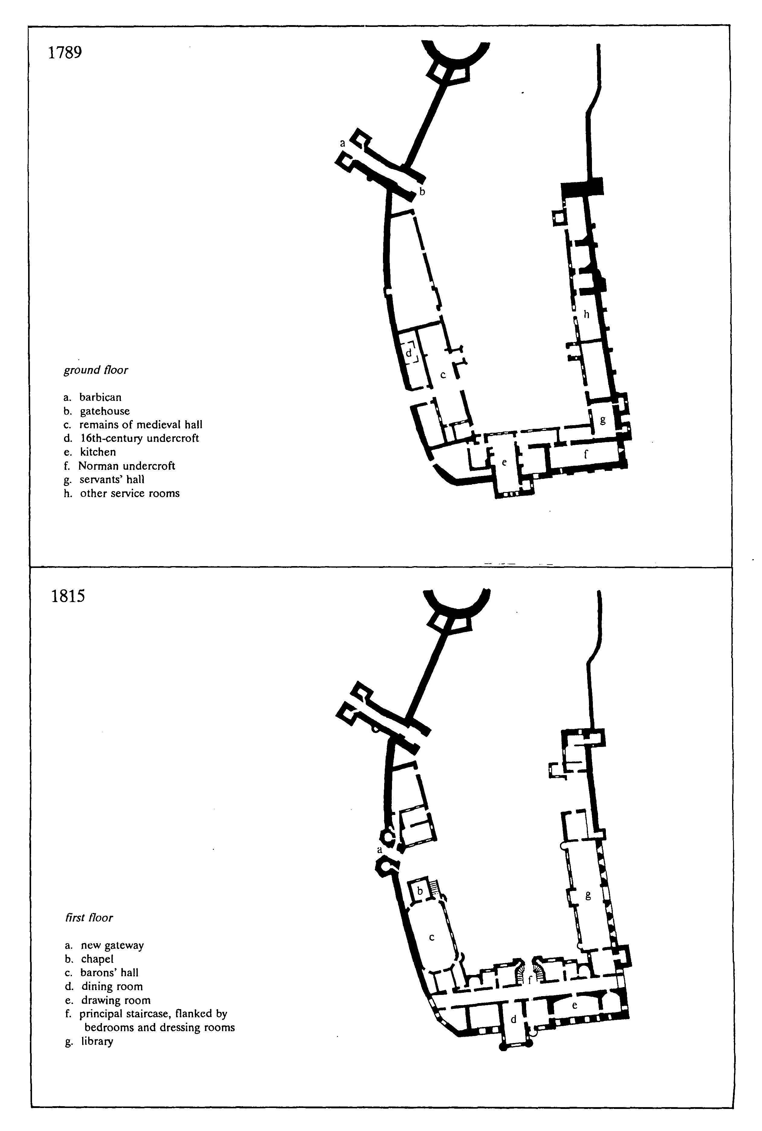
Arundel Castle in 1789 and 1815
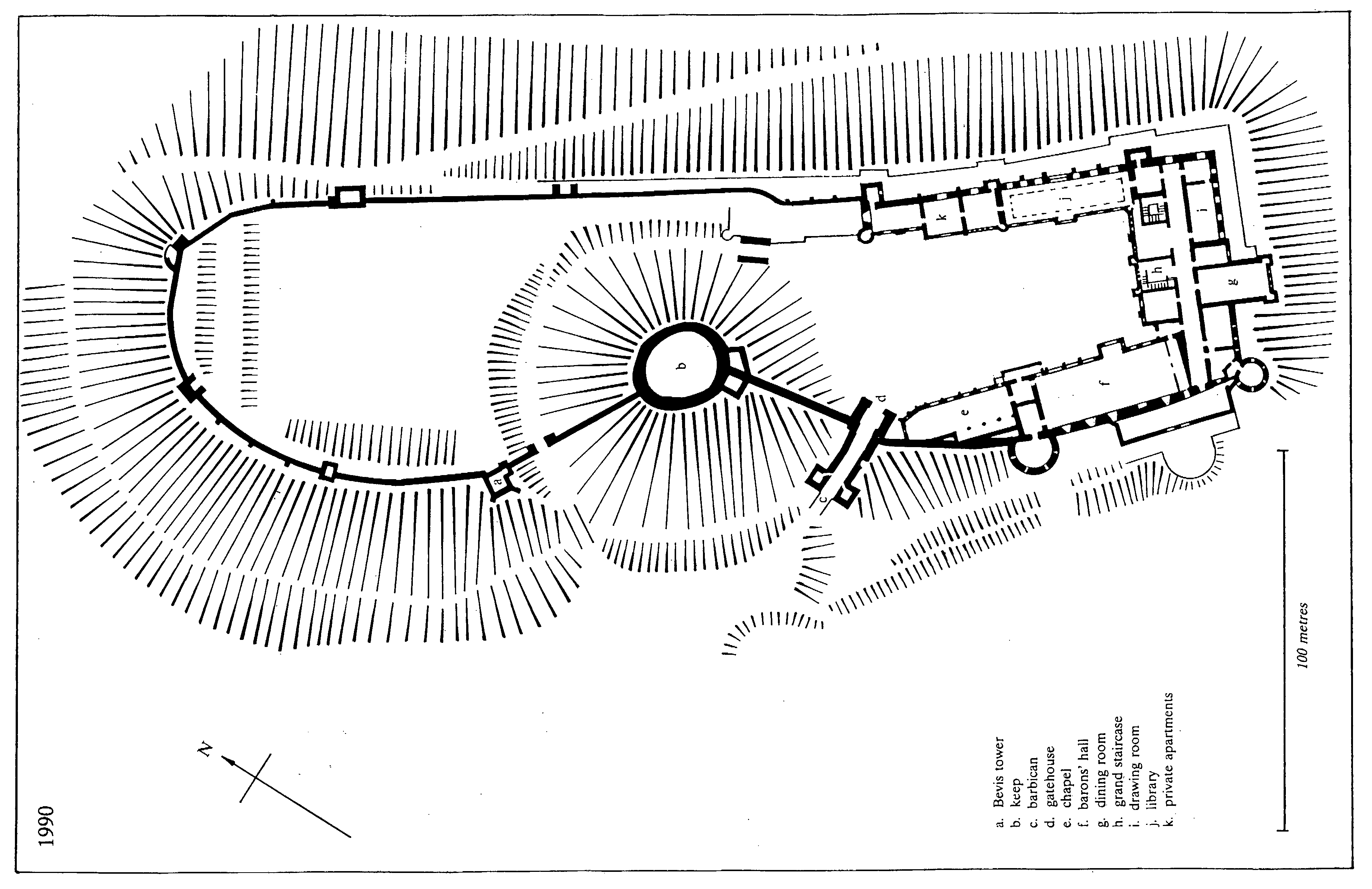
Arundel Castle In 1990
The first plan of the duke's architect Francis Hiorne (fn. 894) was apparently to restore the medieval gatehouse and keep and to link them to new castellated buildings to be built in the north bailey, clearing the south bailey completely to give a prospect over the Arun valley. After Hiorne's death in 1789 the duke decided to rebuild on more conventional lines and to be his own architect, (fn. 895) using as executants workers from his Cumberland estate whom he sent to London to train under leading architects and sculptors; one of them, James Teasdale, described himself as an architect in 1806. (fn. 896) In style the new work was to conform to the medieval buildings, and brown Whitby stone was chosen for much of it to match the medieval stonework in colour. (fn. 897) Duke Charles's work is paralleled in the mid 18th-century alterations at Warwick castle (fn. 898) and in the early 19th-century rebuilding of Windsor castle, (fn. 899) but by contrast was intended to express anti-monarchist, libertarian ideas.
Work began in 1791 or 1792 (fn. 900) on heightening the medieval tower at the south-east corner of the south bailey. During the 1790s the rest of the south-east range was extensively restored, the old walls being preserved. A new kitchen was built on the ground floor by 1800. On the first floor the medieval chapel was replaced between 1796 and 1801 by a dining room projecting beyond the south-east front, with a richly carved Gothic music gallery at its north-west end. (fn. 901) The room was lit by a 20-ft. (6-metre) high painted-glass Gothic window by Francis Eginton representing Solomon entertaining the Queen of Sheba, the figure of Solomon being a portrait of the duke. (fn. 902) The 18th-century rooms were partly refitted in a similar Gothic style. (fn. 903) The great drawing room was apparently complete by 1799, (fn. 904) and the duke's sitting room by 1805. (fn. 905) The drawing room in 1815 was lined with crimson velvet. (fn. 906) The 18th-century corridors giving access to the rooms in the south-east range were preserved, but had to be chiefly end-lit, as the north-west front of the range was advanced a further 24 ft. (7 metres) into the bailey to accommodate bedrooms for the duke's family. (fn. 907) A double-return staircase rising through two floors, with a Gothic balustrade, was built by 1799; it was separated from the first-floor corridor by five stone arches, alternately semicircular and pointed, with Norman mouldings. (fn. 908) The symmetrical front of the range towards the bailey was built between 1795 and 1800 of Bath and Portland stones with a large Norman entrance archway; (fn. 909) flanking the staircase window above it were larger than life-size Coade stone figures of Liberty and Hospitality made in 1798 and perhaps designed by John Bacon the elder. (fn. 910) The rest of the south-east front towards the valley was reconstructed before 1804, the 18th-century sash windows being replaced by Gothic ones including tall lancets in the first-floor rooms; twin turrets flanking the projecting dining room provided another vertical accent. (fn. 911)
In 1801 (fn. 912) work began on the north-east range of the south bailey. On the ground floor a ribvaulted Norman-style undercroft with a Norman archway at each end (fn. 913) gave access from the bailey to a terrace outside. On the first floor was created an aisled and galleried library c. 120 ft. (37 metres) long in Perpendicular style, with decorative details taken from particular medieval buildings; it was near completion in 1805 and finished by 1814. (fn. 914) The symmetrical façade of the library towards the bailey was Norman in style on the ground floor and 15th-century Gothic above; in the centre was a square projecting entrance tower with an oriel window. (fn. 915) Northwest of the library a room called the Alfred saloon had been added by 1814, (fn. 916) being fronted towards the bailey over a three-bayed arcade by a huge Coade stone bas-relief of King Alfred instituting trial by jury on Salisbury plain which was sculpted in 1797; (fn. 917) the room itself was unfinished in 1834. Beyond it the north-west end of the 16th-century range survived in 1876. (fn. 918)
The remains of the medieval hall on the southwest side of the south bailey, (fn. 919) occupied in the 18th century as stables and coach house with an entrance through the curtain wall, were cleared away in 1806. Work began in the same year on a battlemented 'barons' hall' 70 ft. (21 metres) long, an early example of such a full-blown medieval revival. (fn. 920) The room, dedicated to 'Liberty championed by the barons in the reign of King John', (fn. 921) was on the first floor, above a Norman arcade fronting the bailey which also carried a paved walk to give access; its outer wall was the medieval curtain wall. In style it was 14th-century, and the elaborate roof of Spanish chestnut was inspired distantly by surviving medieval roofs; the plan, however, an elongated octagon, and the marble chimneypiece were far from medieval. (fn. 922) At the south-east end of the room was a musicians' gallery. The opposite end wall had a large painted-glass window by Joseph Backler representing the signing of Magna Carta, but only eight of the 12 projected side windows by Eginton showing ancestors of the duke were completed; (fn. 923) the figures were described in 1834 by the painter Constable as resembling 'drunk bargemen dressed up as crusaders'. (fn. 924) The room was nearly ready for roofing in 1814, (fn. 925) but could be fitted up only temporarily in 1815 for the fete to celebrate the sixth centenary of the signing of Magna Carta. (fn. 926) It had still not been completed in 1834 despite a provision in Duke Charles's will, (fn. 927) and was not used at Queen Victoria's visit in 1846. (fn. 928)
North-west of the barons' hall (fn. 929) a small new chapel in 15th-century style was in progress in 1806 (fn. 930) and complete externally by 1814, with pinnacled buttresses and Perpendicular tracery. (fn. 931) The interior was finished by 1825 (fn. 932) and the chapel was in use in 1845. (fn. 933) Beyond it a new gateway had been begun in 1809 to give a less constricted access to the south bailey than that provided by the medieval gatehouse, which in the later 18th century was considered low, crooked, and gloomy. (fn. 934) Intended to be 88 ft. (27 metres) high, and with a low four-centred arch, machicolations, and tall flanking hexagonal turrets, it had reached only 68 ft. (21 metres) before work ceased. In 1834 it had a temporary covering of wood, and it was still unfinished in 1851. (fn. 935) The first-floor corridor of the southeast range was continued along the south-west range by a paved promenade on the curtain wall c. 250 ft. (76 metres) long, which extended through the new gateway to the medieval gatehouse and gave fine views over the coast. Between the new gateway and the old gatehouse remains of one-storeyed medieval buildings still stood in 1856. (fn. 936)
Duke Charles's state rooms all had fittings of dark mahogany with carving of very high quality; (fn. 937) the surviving library is an example. (fn. 938) The gloomy effect was criticized after his death, as were the low proportions of the interiors and the lack of overall coherence in the design. In particular, Loudon in 1829 considered the south bailey lacked dignity because of its irregular shape, the poor design of its elevations, and the drop in level between the new gateway and the entrance to the south-east range. (fn. 939)
Little seems to have been done to the castle by Duke Bernard Edward (succ. 1815; d. 1842), but much refurbishment was carried out shortly before Queen Victoria's visit in 1846 by the firm of Morant, a royal suite of six rooms being created on the second floor of the south-east range. (fn. 940) About 1849 the Bevis tower was restored by William Burn, who also made unexecuted designs for further work between 1848 and 1853. (fn. 941) The King Alfred bas-relief in the south bailey was perhaps removed c. 1853. (fn. 942)
In 1859 (fn. 943) Duke Henry Granville (d. 1860) began a programme of new building to the designs of M. E. Hadfield of Sheffield in a simpler and more massive Gothic style than that of Duke Charles, stone from Whitby again being used. The early 19th-century chapel and the unfinished gateway to the south bailey were demolished, and a new flint and stone gateway was built in 14th-century style. A grand staircase led thence to the barons' hall, forming a more direct entrance to the state rooms, while to the north-west, reached by an antechapel over the gateway, was a new five-bayed chapel, also in 14th-century style, above a ground-floor crypt. The chapel was to accommodate 200 persons seated, with a separate entrance for Catholics from the town. The crypt was nearly complete in 1861 and the shell of the building was finished by 1868; (fn. 944) in 1876 the chapel had a dedication to St. George. (fn. 945) In 1887 it was described as white, lofty, and very cold; it was not then in use, Duke Charles's dining room having reverted to its former use as a private chapel, (fn. 946) and the town congregation using the new church opened in 1873. The great Magna Carta window from the barons' hall was removed before 1866. (fn. 947)
A much larger programme of new work (fn. 948) was carried out by Duke Henry (d. 1917) between 1875 and 1909, almost all to the designs of the herald C. A. Buckler in 13th-century style, and using grey Somerset limestone in large part. (fn. 949) Like his father's work that of Duke Henry was austere and scholarly, the opposite of Duke Charles's; in place of Republican sympathies it expressed authority and tradition, much use being made of heraldic decoration. It parallels the contemporary work of the marquess of Bute at Cardiff castle and Mount Stuart (Bute), (fn. 950) and contains notable decorative work, including sculpture by Thomas Earp and stained glass by Hardman and Co. Part of the cost was met by sales of land in Sheffield. (fn. 951)
The state rooms in the south-east range (fn. 952) were reconstructed between the mid 1870s and c. 1900. Work was going on on the drawing room between 1875 and 1877. The dining room was rebuilt and extended further south-eastwards during the 1890s; it is of stone, with tall transverse arches and a timber minstrels' gallery. Duke Charles's main staircase was replaced in the early 1890s by a high, vaulted one of stone and Derbyshire marble which, however, went only between the first and second floors, small side stairs connecting with the ground floor. The side walls of the staircase carry statues, including the patron saints of the duke and duchess. At about the same time the first-floor corridor was rebuilt in stone with a ribbed vault. The southeast front overlooking the Arun valley was partly altered between 1879 and 1882, (fn. 953) and further reworked during the 1890s, when the new dining room was flanked by square turrets battered at the base. The façade of the range towards the south bailey was refaced in the early 1890s, acquiring a slightly projecting central tower.
A new kitchen and other offices (fn. 954) were built in the south-west wing between 1879 and 1882, the tall kitchen projecting beyond the medieval curtain wall. The rest of the south-west wing was completely rebuilt during the 1890s in a mixture of flint and ashlar. Hadfield's gateway and chapel were pulled down, the entrance to the bailey was re-routed through the medieval barbican and gatehouse, following the suggestion of Tierney, (fn. 955) and a new ground-floor chapel was built in 13th-century style. Of stone and Purbeck marble with stone vaulting and carving by Earp, it has an apse, two liturgical north aisles, a west gallery, and stained glass by Hardman and Co. The early 19th-century barons' hall still apparently stood in 1891, when it was the setting for the sale of 18th- and early 19th-century fixtures and fittings, including the Coade stone statues of Liberty and Hospitality made in 1798. (fn. 956) Its huge successor, with a hammerbeam roof and two end galleries, was finished by 1896 when the Sussex Archaeological Society lunched there, (fn. 957) but decorative features, including more stained glass by Hardman and Co., were still being added in 1899. (fn. 958) The new entrance to the state rooms, made c. 1894, (fn. 959) was through an unobtrusive ground-floor doorway between hall and chapel leading into a low vaulted undercroft, thence up a staircase, and so through the barons' hall. Externally the south-west range was articulated by two tall round towers of ashlar, also of the 1890s, which are battered at the base.
Between 1879 and 1882 the north-east range (fn. 960) was continued north-westwards by a billiard room, breakfast room, and boudoir en suite with the library, other private apartments being created above and below. A new ground-floor entrance to those rooms was provided from the bailey. The boudoir, large, white, and with a heavy timber ceiling, was described in 1887 as 'not like an ordinary boudoir'. (fn. 961) The facade of the range towards the bailey was closed to the north-west by a tall octagonal turret containing stairs to Duchess Flora's terrace garden, created at firstfloor level to the north-west and linked to the north bailey garden. (fn. 962) The medieval tower at the north-east angle of the boudoir was restored and heightened as a vertical accent in the castle's silhouette. The entire length of the façade to the bailey was refaced. Alone of the major early 19th-century interiors the library was not destroyed, though its classical white marble chimneypieces were replaced c. 1897–1900 by Gothic ones contrived in recesses like chantry chapels in the thickness of the medieval curtain wall. (fn. 963) The private apartments on the second floor, of the 1890s and early 1900s, have internal timber-framing more domestic in character than the new rooms below.
The castle was entirely lit by electricity in 1897. (fn. 964) Many other contemporary services were similarly advanced, including service lifts, central heating, and the fire-fighting system. (fn. 965)
Duke Henry also set about restoring the ruined medieval parts of the castle, making them visually part of the modern house as they had not been before. In the early 19th century the remains of the keep had been covered in ivy both outside and in, (fn. 966) and from c. 1800 or before it was the haunt of several large horned owls; (fn. 967) in 1802 there were also an eagle and other foreign birds. (fn. 968) The owls remained until 1868 or later. (fn. 969) The medieval gatehouse and barbican were also ivy-covered in the mid 19th century. (fn. 970) The keep was cleared of ivy in 1875, the walls being carefully restored. (fn. 971) Before 1876 the ground level under the gatehouse, which by the 18th century (fn. 972) had risen c. 3 ft. (1 metre), was lowered to bring the entrance back into use; (fn. 973) the medieval doors, adjusted to the 18th-century level, remained c. 3 ft. shorter in 1991. The restoration of the curtain wall and towers in the north bailey was being considered in the 1880s, (fn. 974) but little was done before 1901, when Buckler advocated using the surviving section next to the keep as a model. (fn. 975) The Bevis tower was restored in 1901–2, a new top storey being added. (fn. 976) At the top of the north bailey an oratory was created in the thickness of the curtain wall. The wall walk was complete by 1907. (fn. 977) Meanwhile the keep was fully but conservatively restored in 1905–6 under John Morley of Cambridge. (fn. 978) An external gateway to the north bailey had apparently been made south-east of the Bevis tower in the early 19th century; (fn. 979) it was replaced before 1909 by a new one, the moat being deepened to its original level at that point and crossed by a picturesque bridge. At the same time a gate was built between the two baileys. (fn. 980) The Coade stone lion and horse which flank the north bailey drawbridge were brought from the old New Shoreham suspension bridge at its demolition in the 1920s. (fn. 981)
Duke Henry's restoration left the castle's silhouette much more striking than before, especially when seen from the river valley to the east. The south bailey elevations, however, were little better co-ordinated, being still too varied in rooflines, floor levels, and fenestration, while the concealment of the entrance was both confusing and denied a potential focus for the design.
The castle was again extensively restored and repaired after 1975. (fn. 982) The late 19th-century private rooms in the north-east range were restored in the 1990s for permanent occupation by the family of the duke of Norfolk's eldest son Lord Arundel. (fn. 983)
CASTLE GROUNDS.
A garden in the castle was mentioned between 1187, when it was in front of the king's chamber, (fn. 984) and the later 16th century. (fn. 985) In the late 13th century and early 14th there was also a garden outside, apparently in the Little park. (fn. 986) The old kitchen garden used as an orchard in the 1630s was evidently nearby, since it lay at the castle gate next to Castle green, (fn. 987) in an area described either as the outer court of the castle (fn. 988) or as part of the Little park. (fn. 989) There were apple, pear, plum, and filbert trees there in 1635. (fn. 990) A fishpond apparently in Park bottom was mentioned in 1275. (fn. 991) The surviving fishponds below the castle to the east may also be medieval. They seem to have been in use in 1636, when a 'new kitchen garden' lay near them. (fn. 992) A dovecot of unknown site was mentioned in 1576–7. (fn. 993)
In the 1630s the north bailey of the castle was used as a garden. (fn. 994) A formal layout may have existed in 1706; (fn. 995) then or later a spiral path, still visible in 1987, was made on the north side of the motte. In the later 18th century the north bailey contained the kitchen garden as well as the flower garden, (fn. 996) and had three stepped terraces at its north end (fn. 997) which also remained in 1987. An apricot tree planted in the mid 18th century covered c. 1,000 sq. ft. (93 sq. metres) of the curtain wall in the 1830s, producing large quantities of fruit, chiefly for tarts. Five large standard fig trees then also bore good crops. (fn. 998)
In the early 19th century or perhaps earlier the kitchen garden was moved elsewhere, (fn. 999) and by 1835 the north bailey had been laid out in an early revival of the formal parterre with flowers, shrubs, and a central fountain. (fn. 1000) The outer face of the north bailey earthwork near the Bevis tower was thickly planted with shrubs and trees by 1825, (fn. 1001) as the motte had been earlier. (fn. 1002) In 1874 there were laurels and bays among the bedding plants in the north bailey, fruit trees and ivy along the curtain wall, and pampas grass on the terraces. The parterre was removed between 1885 (fn. 1003) and 1900; at the latter date there were four lawns with topiary bushes. (fn. 1004) In 1902 Gertrude Jekyll made designs for eight large beds bordering a central lawn; (fn. 1005) the single lawn had been created by 1914 (fn. 1006) and remained in the late 20th century, when the area was known as the tiltyard. There was a swimming pool in the lawn between the late 1930s and 1976, (fn. 1007) and in 1987 the lawn was flanked by shrubs, topiary trees, and palm trees. Both sides of the motte were still planted with yews in 1914, (fn. 1008) but they were later removed.
After his succession in 1815 Duke Bernard Edward (fn. 1009) set about improving the surroundings of the newly restored castle to gain more privacy; in the same way as earlier at Warwick castle, (fn. 1010) that was achieved partly at the town's expense. Houses at the north end of High Street opposite the churchyard were engrossed in the later 18th century and earlier 19th and demolished; (fn. 1011) their plots, together with the site of the 'outer court' mentioned above, were laid out before 1817 with lawns, shrubberies, and plantations. (fn. 1012) By the mid 19th century there was a conservatory on the lawn east of the churchyard, which had gone by 1896. (fn. 1013)
The original approach to the castle had evidently been through the Little park, curving towards the medieval barbican and gatehouse. (fn. 1014) In 1785 there was a gate in High Street near the north-east corner of the churchyard, (fn. 1015) but with the closure of the upper part of High Street it was replaced by a 'commonplace brick cottage' on the site of the present High Street lodge, a drive being laid out from there to Duke Charles's new south bailey gateway. (fn. 1016) In the mid 19th century further houses on the east side of High Street were demolished opposite Maltravers Street and the new London road, their plots also being thrown into the castle grounds. (fn. 1017) The part of the castle's western ditch along the south bailey was then apparently removed. (fn. 1018) A new lodge in Gothic style, and matching castellated stretches of wall to south and west of it, were built of grey Purbeck limestone in 1850–1 to the design of William Burn. (fn. 1019) The entrance drive acquired at the same time low flanking embattled parapets. (fn. 1020) By the mid 19th century the closure of Marygate Street and of the right of way from the top of the present High Street to the north door of the church (fn. 1021) had enabled the medieval town wall earthwork east of the Marygate to be laid out in two terraces. By then, too, the Fitzalan chapel of the church had come to seem like a proprietary chapel, almost a garden ornament. Some specimen trees from the mid 19th century remained in the area in 1996. (fn. 1022)
To the north-east and south-east the castle precinct was bounded in the early 19th century by Mill Lane. There had been a wall along the lane in the later 18th century (fn. 1023) and perhaps earlier, (fn. 1024) with a gate by the later 18th century (fn. 1025) which in the mid 19th was called the bowling green gate. (fn. 1026) The bowling green in the grounds south of the castle is mentioned elsewhere; (fn. 1027) in the later 18th century there was also a gazebo nearby. (fn. 1028)
Duke Henry Charles in 1850 attempted to enlarge the grounds eastwards by replacing Mill Lane with a new road further from the town. (fn. 1029) That would have included, besides the earlier fishponds, the new dairy built in 1844–5 to the design of Robert Abraham on the site of Swanbourne water mill. Of flint in Tudor style, it was octagonal in plan with a wooden veranda and crowning lantern. Adjoining, and in the same style, were cowsheds and a dairyman's residence, together with a reading room for Duchess Charlotte opening on a terrace walk with an ornamental garden below. (fn. 1030) There was also a kitchen garden nearby in 1874. (fn. 1031) In 1893 the dairy supplied butter, milk, and cream daily to the family even when in London; the surplus milk was given to the poor. (fn. 1032) The building was open for public inspection between 1849 and 1934. (fn. 1033) In 1980 and later it was let to the Wildfowl Trust. (fn. 1034)
The Little park north-west of the castle (fn. 1035) was considered as part of the pleasure grounds in the mid and later 19th century, (fn. 1036) the easternmost section of the medieval town wall earthwork apparently being removed to give access and a vista to it. Beyond the park to the east the slopes of the river cliff were laid out with paths during the 19th century, one of which led from the north bailey to the dairy. (fn. 1037)
After the replacement of Mill Lane by Mill Road in 1894 the boundary of the castle grounds was extended eastwards to the latter, where a new lodge, more convenient for the railway station, was built c. 1896 to the design of C. A. Buckler. (fn. 1038) A new entrance drive led by a serpentine route to the medieval barbican, by then again in use, and the previous entrance drive was landscaped away.
The lack of an overall plan for the castle grounds, which Loudon had criticized in 1829, (fn. 1039) was still evident in 1989, when in addition the Little park was no longer directly accessible from them and the eastern slopes below the castle had become overgrown and largely impassable. A major programme of redesign began soon afterwards. The lie of the land still meant, however, as Tierney had noted in 1834, (fn. 1040) that the residential parts of the castle had no outlook over either the gardens or the park.
During the 19th and 20th centuries the closure of the old London road through the Marygate (fn. 1041) made possible a further expansion of the castle precincts west and north-west of the church. The site of the Maison Dieu west of the churchyard may have been a kitchen garden by c. 1800 if its high red brick walls are partly 18th-century, as they seem. By 1815 (fn. 1042) it had become the chief kitchen garden for the castle. In the early 19th century there was a 'garden house' there (fn. 1043) and by 1841, when there were hothouses and pine pits, figs and wall fruit were also grown. (fn. 1044) Two iron-framed hothouses and two span-roofed houses were erected by the firm of Jones and Clark, later Henry Hope Ltd., in 1853–4; (fn. 1045) one of the former survived in 1996. There were other glasshouses in the area by the 1870s, when fruit grown included peaches, grapes, figs, cherries, pineapples, and strawberries. (fn. 1046) The garden gates were made in 1937 as a wedding present for Duke Bernard (d. 1975). After 1975 (fn. 1047) the area ceased to be used as a kitchen garden, part becoming a visitors' car park and part a tea garden.
By the early 19th century (fn. 1048) the stables and coach house had been moved from the south bailey of the castle (fn. 1049) to a site north of the Marygate. Further north, the present stable courtyard was then a farmyard, (fn. 1050) with a 'deer house', either for hanging venison or for housing deer in winter, at its south-east corner; the building, which survived in part in 1988, was of knapped flint with stone dressings in the same Gothic style as Duke Charles's work at the castle. West of the farmyard in the early 19th century lay the estate timber yard and carpenter's shop, later the estate building yard. (fn. 1051) A large domed ice house was constructed east of the old London road opposite the deer house at about that date.
By the mid 19th century the former stable area had become an orchard, the stables moving to their later site, (fn. 1052) where the old farm buildings were replaced. A red brick and stone drill hall was put up near the building yard in the later 19th century; (fn. 1053) it was converted to cottages in 1946–7. (fn. 1054) The stable courtyard housed the estate fire engine in 1942, (fn. 1055) but the coach house was converted to cottages c. 1947, (fn. 1056) vehicles later being kept in the former castle electricity station, (fn. 1057) of red brick and half-timbering, which had been built west of the kitchen garden c. 1894. (fn. 1058) By 1970 the stable yard accommodated racehorses. (fn. 1059) Ten bungalows for stable staff were built nearby in the 1950s. (fn. 1060) Meanwhile the estate building yard had expanded to the north-west, where a steam sawmill was built by 1875, a railway joining the two sites. (fn. 1061) After c. 1983 the old building yard became the estate office; the sawmill, however, remained in use.
The Marygate lodge on the old London road north of the stable courtyard was built c. 1853–5 to the design of William Burn. (fn. 1062)
By 1874 the kitchen garden had expanded westwards beyond the London road; the new area, which was reached by a tunnel, sloped southwards, suiting early crops, (fn. 1063) and was said to be the chief vegetable garden for the castle in 1885, when it also supplied flowers for the high altar of the Catholic church. (fn. 1064) It ceased to be used in the mid 20th century. (fn. 1065)
WOODS AND PARKS.
Arundel parish lay within the forest or chase of Arundel, which extended from the river Arun almost to the Hampshire border and from the coast to the north side of the South Downs. (fn. 1066) There were two medieval parks in the parish, the Great park in the west, which later became Park farm, and a home park called the Little park, which in 1995 was the castle cricket ground. The modern landscaped park north of the town was created in the late 18th and early 19th centuries, and extends into South Stoke and Houghton.
Great park.
The Great park was apparently made by Roger de Montgomery (d. 1094), since a hide formerly of Tortington was included in it between 1066 and 1086. (fn. 1067) It was not adjacent to the castle, but occupied less fertile land in the west part of the parish. (fn. 1068)
In 1275 the north and south boundaries of the Great park seem to have been roughly those of the ancient parish; on the east side the pale ran above Park bottom to the east, and on the west side west of the modern Park Farmhouse. (fn. 1069) The park was said to contain 450 a. in 1589. (fn. 1070) In 1570 the pale was said to be three miles round, (fn. 1071) but by the earlier 17th century its eastern side seems to have been removed. (fn. 1072) The park was apparently enlarged before 1636, when its total area was given as 845 a. (342 ha.), including 216 a. called the new ground; a distinction was then made between the 494 a. south-west of Park bottom and the 117 a. north-east of it. (fn. 1073) In 1661 the park was said to have 823 a. (fn. 1074) and in the 18th century between 823 a. and 960 a. (fn. 1075) Much of the pale was destroyed during or after the siege of the town in 1643–4. (fn. 1076) Repairs were carried out in and after 1657, (fn. 1077) though in 1675 only the south side and the southern parts of the east and west sides seem still to have existed. (fn. 1078) Traces of the bank survived on the south side in 1996 near the beginning of the track leading from the ChichesterArundel road to Slindon. (fn. 1079)
The main gate to the park, at the south-east corner, may have been called Parkgate in the early 15th century. (fn. 1080) Two other gates besides were mentioned in 1275. (fn. 1081) The gate in or near Park bottom by the leper hospital was presumably the same as the Hermitage gate of 1661; the 'gate of Bogherwerth', evidently on the north side, was perhaps replaced by Sherwood gate mentioned in 1661. Other gates recorded in the 17th century were 'Boyers', presumably Bowyers, gate (fn. 1082) on the south-east; Slindon gate, a 'postern gate', and 'Glastis' gate on the south-west (the first two perhaps the same); and Betts gate on the south, possibly replacing the 'stile (scaleram) of Tortington' mentioned in 1275. (fn. 1083) Yewtree gate on the north-west side was mentioned c. 1875. (fn. 1084) In 1275 there were two deerleaps on the east side and two or more on the west.
Oak timber was mentioned in the park in 1244 (fn. 1085) and 1280, beech between 1280 (fn. 1086) and 1722, (fn. 1087) and maple in 1661. (fn. 1088) In 1570 the park was said to be 'indifferently well wooded' (fn. 1089) but in the earlier 17th century it seems to have been chiefly woodland, (fn. 1090) though much timber was cut down in 1644, partly to repair the castle and partly to remove possible cover for an advancing enemy. (fn. 1091) Both underwood and wind-fallen wood were apparently sold in 1275, (fn. 1092) and wood in both the Great and Little parks in 1525–6. (fn. 1093) In the mid 17th century 110 a. in the south-west part of the Great park were managed as coppice for sale, as the Waterwood (29 a.) in the south-east may also have been. (fn. 1094) In 1702 a wood in the Great park belonged to a Mr. Fugar, presumably the shipwright Joseph Fugar. (fn. 1095)
Sherwood plain in the north-west and Crossham lawn in the south-west, both mentioned in 1661, (fn. 1096) and East and West Waterwood plain mentioned in 1772 (fn. 1097) were perhaps survivals of medieval 'lawns' or areas of open grassland. There were at least 28 a. of meadow in 1272, (fn. 1098) perhaps in Park bottom, where Pond mead was mentioned in 1732, (fn. 1099) or on the south side, where meadow land in 'Parkwysse' was mentioned in 1275 (fn. 1100) and Rooks mead, producing hay, in 1658. (fn. 1101)
Deer are recorded in the Great park in the later 13th century; (fn. 1102) in 1301 the earl of Arundel could take five bucks and seven does a year. (fn. 1103) Henry VIII enjoyed hunting there in 1526. (fn. 1104) In 1570 there were 300 or 400 fallow deer and c. 24 red deer; (fn. 1105) 'stately herds of deer' were seen by a visitor in 1635. (fn. 1106) About 500 deer were said to have been killed by the Parliamentary soldiers in 1644. (fn. 1107) The herd was replenished in or before 1659 from Cowdray park near Midhurst. (fn. 1108) In 1657 there was a deer house in the park, (fn. 1109) either for hanging venison or for housing animals in winter.
Pannage for swine was mentioned between the later 12th century and 1589; in 1525–6 the income from the Great and Little parks together was £8 2s. 8d. (fn. 1110) There was both winter and summer pasture for cattle in 1275, (fn. 1111) and in 1525–6 the agistment of the two parks produced £1 4s. 6d. (fn. 1112) Cattle were still kept in 1658, when Lady Anne Howard, wife of Henry Howard of Albury (Surr.), later duke of Norfolk, had a dairy apparently in the Great park; at about the same date her husband's horses seem also to have grazed there. (fn. 1113) There were rabbits in the park in 1644, (fn. 1114) and in 1702, when they were spoiling the trees. (fn. 1115) An eyrie of sparrowhawks in the park was destroyed by bustards before 1272. (fn. 1116)
A keeper was mentioned in 1244, (fn. 1117) and a parker, who rendered annually for his bailiwick a silver cup worth 13s. 4d., in 1272. (fn. 1118) A ranger in the early 15th century was apparently responsible also for the Little park. (fn. 1119) By 1576 the office of keeper of the Great park had become honorific and was held by a gentleman. (fn. 1120)
A keeper's lodge was mentioned in 1570, (fn. 1121) and in the early 17th century occupied a roughly central site in the park. (fn. 1122) In 1636 it had adjacent yards and gardens. (fn. 1123) It was repaired in the later 1650s, (fn. 1124) perhaps after Civil war damage. Another lodge called Bowyers lodge in 1636 perhaps lay in the south-east. (fn. 1125) There was a lodge in the north part of the park besides in 1732. (fn. 1126)
A fishpond apparently within the park was mentioned in 1275. (fn. 1127) It was perhaps the same as the great pond of 17 a. which in 1636 lay in Park bottom near the south-east corner of the park. (fn. 1128) Fish from the pond were sold in 1662. (fn. 1129)
In 1702 the Great park was let. A rabbit warren was felt to be the most suitable use because of the poor soil, (fn. 1130) but in 1732 the duke of Norfolk leased the land to Abraham Ibbotson for 11 years for conversion to a farm. (fn. 1131) A large area was arable in 1772, when sheep were kept as well; there was a barn on the site of the modern Park Farmhouse. The closes in 1778 were large. In 1772 there were still 190 a. of woodland in the former park including the Waterwood; East Sherwood rough and Red Lane rough in the north; and Cricket Hill wood in the east. (fn. 1132) Part of the north end of the former park remained rough ground in the 1870s, (fn. 1133) and in 1986 was open grassland with some large spreading beeches and yews of parkland type.
The Rewell.
The area called the Rewell west of the Great park formed a separate bailiwick (fn. 1134) or 'walk' (fn. 1135) of Arundel forest. In the mid 16th century it extended into Madehurst, (fn. 1136) and in 1570 it was said to be c. 20 miles round; (fn. 1137) the total area was given as 335 a. in 1636 (fn. 1138) and c. 380 a. in the late 19th century. (fn. 1139) It is not clear whether the linear earthwork which is followed by both its western boundary and that of the parish is medieval or earlier. (fn. 1140) The Rewell had its own ranger in the early 15th century (fn. 1141) and its own keeper or forester in the 1570s, (fn. 1142) but in 1589 the keeper was also keeper of the Great park. (fn. 1143) No record of a separate keeper has been found after 1605. (fn. 1144) A keeper's lodge stood roughly in the centre of the Rewell in the early 17th century. (fn. 1145)
In the Middle Ages the Rewell apparently had both woods and open pasture. (fn. 1146) Common pasture rights were mentioned in 1302. (fn. 1147) There is no medieval evidence that the Rewell was commonable by all the inhabitants of an area of the county like the Wealden commons of the lathes of Kent, (fn. 1148) though the pasturing of pigs there in 1587 by two men of Angmering and Amberley suggests it. (fn. 1149) Enclosures of oblong shape whose earthworks survived in the late 20th century seem likely to be medieval pastoral enclosures. (fn. 1150) Deer were kept at the Rewell in 1331 (fn. 1151) and in the 17th century, (fn. 1152) and pannage for pigs brought in £10 9s. 6d. in 1525–6. (fn. 1153) Sheep, cattle, and horses were all pastured there c. 1600. (fn. 1154)
By 1636 the Rewell contained 245 a. of woods and only 90 a. of pasture, called the Plain; (fn. 1155) it remained mostly woodland thereafter. (fn. 1156) There was mixed coppice with standard trees, chiefly birch and oak, in the early 18th century, when timber there was apparently sold to the shipbuilder George Moore. (fn. 1157) By 1772 the area had been laid out with the diagonal rides to facilitate shooting (fn. 1158) which remained in 1991. In 1929 the south-facing slopes were thickly clad with hazel and sweet chestnut. (fn. 1159) By 1981 Rewell wood, comprising 288 a. in Arundel, Binsted, and Houghton, was let to the Forestry Commission; (fn. 1160) beech, sweet chestnut, and conifers grew there in 1987.
Other woods in the parish included the earl's wood called Moselee in 1158, (fn. 1161) which has not been located but may be the same as the wood of Arundel mentioned in the 1270s, (fn. 1162) and the hangers on the cliff above the river Arun: Park or Little park hanger mentioned from 1636 and Castle hanger mentioned from 1702. (fn. 1163)
Little park.
The Little park north-west of the castle seems to include the area called Wynyard (i.e. vineyard) in 1158, (fn. 1164) which in 1275 was partly a garden and partly pasture. (fn. 1165) The modern name is recorded from 1301, when deer were being kept there. (fn. 1166) In 1570 there were c. 30 fallow deer and two or three red deer. A keeper was recorded at the same date, (fn. 1167) and pannage for swine was taken during the 16th century. (fn. 1168) The park had 26 a. in 1636; (fn. 1169) the 120 a. mentioned in 1589 presumably included land adjacent to the castle considered part of the park at that period. (fn. 1170) Part at least of the pale survived in 1615 and perhaps later. (fn. 1171) The park was let in 1641, (fn. 1172) but was in hand in the early 18th century (fn. 1173) and presumably always thereafter. (fn. 1174) In the 18th century it seems generally to have been used as a home paddock for the castle, (fn. 1175) but there were apparently deer there c. 1750. (fn. 1176) A hay crop was taken in 1711. (fn. 1177)
Only a small part of the Little park was wooded in 1570, (fn. 1178) but beech trees grew there in 1625. (fn. 1179) After c. 1815 the park was incorporated into the enlarged pleasure grounds of the castle. (fn. 1180) In the mid and later 19th century it apparently contained an arboretum, (fn. 1181) and in 1874 it was bordered on all sides by shrubs, with oak, elm, lime, hawthorn, and spruce outside. (fn. 1182) The surrounding earthworks had already been overgrown with trees, notably elm and beech, by 1828, making a striking backcloth to the church and castle as seen from Crossbush in Lyminster. (fn. 1183) The trees were thinned after storm damage in 1989–90. Meanwhile, the central area of the park had been levelled in 1895 to create the castle cricket ground. (fn. 1184)
The modern park.
The rebuilding of the castle after 1786 required a setting worthy of it and, as earlier at Warwick (fn. 1185) and Petworth, (fn. 1186) a large new park was created beyond the Little park to the north, on the site of arable, sheepdown, and a rabbit warren in South Stoke parish. (fn. 1187) Much land had been emparked by 1789, (fn. 1188) and by the mid 1790s, after the first diversion of the London road in 1793, the park contained several hundred acres. (fn. 1189) By the 1810s a wall with lodges had been built to enclose over 1,100 a., which could contain 1,000 head of deer. (fn. 1190) The area was not greatly increased thereafter. (fn. 1191) There were at least two keepers in 1815. (fn. 1192) Extensive planting had begun by 1814, clumps of trees, notably beech, alternating with open lawns from which there were wide views of the coast. Pughdean bottom, the valley above Swanbourne lake, was particularly remarked on in 1819 for the contrast of old woods on its west slope with new terraced plantations to the east. (fn. 1193) Besides beech in 1900 there were elm, ash, oak, maple, and various coniferous trees in the park. (fn. 1194) Many trees had reached maturity by 1987, when much damage was sustained in a great storm. Large-scale replanting, mainly with beech, was undertaken later to restore the original appearance of the park.
In the early 1890s there were between 600 and 1,000 fallow deer, many nearly white in colour, and 30 red deer which chiefly lived in the remoter and more wooded parts of the park. Other animals kept at the same date were Indian or Brahmin cattle, Cashmere goats, llamas, and South American ostriches. (fn. 1195) Both red and fallow deer could be seen in 1939, together with dark coloured Japanese deer and a few muntjak, but only the red deer remained after the Second World War until their dispersal in 1959. (fn. 1196) Some roe deer lived around the castle earthworks in the 1980s. (fn. 1197)
The new park was evidently open to the public in 1805, (fn. 1198) as it always seems to have been since except for a short time after 1842. (fn. 1199) After the arrival of the railway in 1846 it became a popular object of excursions from the coastal resorts, from Portsmouth, and from London. (fn. 1200) Since the mid 19th century numerous fêtes and similar events have been held there (fn. 1201) and it was the setting for free entertainments given by Duke Henry (d. 1917) to local people to celebrate Queen Victoria's two Jubilees and the Coronation of 1911. (fn. 1202) Between c. 1890 and 1934 summer training camps were held there for volunteers and other army units. (fn. 1203) During the Second World War gallops were laid out in the park for training racehorses. (fn. 1204)
A three-storeyed Gothic banqueting house of triangular plan with polygonal corner turrets was built near the old London road c. 1787. Known from the name of its architect as Hiorne's tower, (fn. 1205) it is of flint and stone chequerwork, and remarkably correct in detail for its date. Its site on the brow of the hill yields fine coastal views and stamps the park as belonging to a castle. The embattled terrace round it was laid out apparently between 1860 and 1879. (fn. 1206) For some years before c. 1960 the tower housed estate workers. (fn. 1207) Nearby stands a Greek altar found at the museum at Sebastopol in 1855. (fn. 1208)
In 1814 there were said also to be Gothic temples and other ornamental buildings in the park, including one called the Ladies' bower. (fn. 1209) Another called Mount Pleasant was covered in ivy in 1817. (fn. 1210) None survived in 1990. A Gothicstyle lodge in flint and stone called the Green Doors lodge was built on the line of the new London road of 1793, perhaps to the design of Duke Charles (d. 1815), and survived in 1989, the second diversion of the London road in 1803 having brought it within the park. (fn. 1211) Butler's lodge, leading into the new park from the town, existed in the early 19th century (fn. 1212) and was later enlarged; it had its present name by 1851. (fn. 1213) There are other lodges in South Stoke and Houghton parishes.
Arundel Park house was built for the duke of Norfolk between 1958 and 1962 as a smaller, more private house c. ½ mile (800 metres) northwest of the castle. Designed by the Hon. Claud Phillimore, it is in early 19th-century classical style with canted wings, and has wide views of the coast. (fn. 1214) Duke Bernard and his family lived there from 1961, (fn. 1215) and in 1995 it was still the home of his widow. Six pieces of classical sculpture from the collection of Thomas Howard, earl of Arundel (d. 1646), stood outside the entrance in 1996. (fn. 1216)
MANOR AND OTHER ESTATES.
The manor or borough of ARUNDEL generally descended with the rape. (fn. 1217) In 1253 it was wrongly said to have been ancient demesne. (fn. 1218)
The descent of the CASTLE is given elsewhere. (fn. 1219) The GREAT and LITTLE PARKS and Rewell wood also descended with the rape. (fn. 1220)
The BURGESS BROOKS, comprising 80– 100 a. in the bend of the river Arun east of the town, were also once part of the demesne lands of the lords of Arundel, but the borough was leasing them by the 1270s, and after the mid 16th century its estate became a freehold. In 1902 the lands were exchanged by the town council to the duke of Norfolk for land in Tortington. (fn. 1221) Meanwhile much other marshland had remained in demesne. (fn. 1222)
Arundel priory had lands in the parish in 1230, (fn. 1223) which in 1291 were rented at 19s. 6d. (fn. 1224) More land was acquired in 1353. (fn. 1225) The priory's property passed in the later 14th century to Arundel college, (fn. 1226) whose holdings were further augmented in 1391. (fn. 1227) In 1535 the college had rents and farms in Arundel worth £4 1s. 11d. (fn. 1228) At the Dissolution its lands passed to Henry FitzAlan, earl of Arundel (d. 1580). (fn. 1229)
Holy Trinity hospital (the Maison Dieu) owned lands in the parish from 1395, (fn. 1230) which at the Dissolution were granted to Sir Richard Lee. (fn. 1231)
Pynham priory in Lyminster had lands in Arundel, including two houses probably on the causeway south-east of the bridge in 1201, land under the castle on its east side about the same date, and a shop and a house on the quay in the early 15th century. (fn. 1232) In 1526 they passed with the priory to Cardinal Wolsey's college at Oxford. (fn. 1233) Between the later 16th century and the mid 18th or later property formerly of the priory descended with Calceto manor in Lyminster in the family of Browne, viscounts Montague. (fn. 1234)
Tortington priory had lands in Arundel by 1291, (fn. 1235) which in the early 15th century included at least three tenements and a store in the market place. (fn. 1236) In the 1530s the total rental was £2 6s. 7d. (fn. 1237)
Other religious institutions holding lands in the parish were Boxgrove priory (including a plot in High Street c. 1216), (fn. 1238) Durford abbey in Rogate, (fn. 1239) the Knights Templar (fn. 1240) and the Knights Hospitaller, (fn. 1241) the dean and chapter of Chichester cathedral (including property in Mill Lane), (fn. 1242) and St. Mary's hospital in Chichester. (fn. 1243) Lyminster priory had property in the town and outside, (fn. 1244) part of which later belonged to Eton college. (fn. 1245)
Arundel church had tithes worth £1 4s. in 1086. (fn. 1246) In 1341 the RECTORY estate included a house and garden, 32 a. of land, and 2 a. of meadow, together with rents worth £1 6s. and tithes of meadow, mills, and fish; (fn. 1247) in 1374 its annual value was said to be £5. (fn. 1248) It remained distinct from the other former lands of the priory after the priory's replacement by Arundel college, but at the Dissolution passed like those to the earl of Arundel, (fn. 1249) descending afterwards with the rape. The estate was let in 1535 (fn. 1250) and later. (fn. 1251) By 1636 the rectory had come to comprise 137 a., chieXy arable and downland, north-west of the town and 28 a. in Tortington. (fn. 1252) In the later 18th century the rectory lands were nearly 300 a. in area, mostly north-west of the town, and were divided into two farms called Parsonage and Rooks farms. (fn. 1253) The lands north-west of the town were afterwards thrown into the new park. At the commutation of tithes c. 1841 the duke of Norfolk as impropriator received £160 tithe rent charge. (fn. 1254)
The rector's house mentioned in 1324–5 (fn. 1255) may have been on the same site as the parsonage house described as south of the churchyard in 1636. (fn. 1256) In 1778 the two portions of the rectory farm each had a house south-west of the church on either side of Parson's Hill. (fn. 1257) One of them at least seems to have survived in 1818, (fn. 1258) but is not heard of again.
In 1772 the Great park and Rewell wood alone were estimated at 1,210 a., virtually two thirds of the parish. (fn. 1259) With the enlargement of the castle grounds and the creation of the new park, (fn. 1260) by c. 1841 the duke of Norfolk owned nearly the whole parish, the only other estate over 20 a. in area being the burgess brooks. (fn. 1261) Three areas of the town besides the castle precincts were largely in his ownership by the mid 19th century: the eastern side of High Street, the upper part of the town, and the southern frontage of the river Arun; (fn. 1262) in 1910 perhaps a third of the town's buildings belonged to him. (fn. 1263) The ducal estate was further increased by the purchase of the burgess brooks in 1902. (fn. 1264) All the rural land was still owned by either the Norfolk or the Arundel estate in 1995, (fn. 1265) but after the Second World War much urban property was sold: c. 120 houses in the north-west part of the town c. 1947, and miscellaneous property, especially in High Street, in 1950. Many sales were to long-term tenants at low prices. (fn. 1266) In 1980 the Arundel estate owned little commercial property in Arundel. (fn. 1267)
AGRICULTURE.
In common with other parishes in the Arun valley, land use in Arundel during the Middle Ages was divided between meadow beside the river, arable on the lower slopes of the downs, and some rough pasture on the highest land. The west part with its poorer soil supported parkland and woods. (fn. 1268)
Open fields mentioned in 1269 (fn. 1269) presumably included the Portfield recorded from 1401 (fn. 1270) and the Limefield and apparently the Mary field in the 17th. The Limefield lay north of the Little park (fn. 1271) and the Mary field perhaps near the Marygate; (fn. 1272) Portfield from its name was presumably also close to the town. (fn. 1273) All three fields seem to have been inclosed by 1636. In that year there was arable beyond the Marygate on both sides of the old London road, the largest holding being Parsonage farm. (fn. 1274) Possibly the west part of the town, which seems to represent later medieval development, had replaced other arable, as apparently happened, for instance, at Lichfield (Staffs.) and Stratford-upon-Avon (Warws.). (fn. 1275)
The 80–100 a. later known as the burgess brooks, which lay east of the town in a meander of the river, (fn. 1276) were common pasture from an early period. Pasture rights there were granted to the burgesses by William d'Aubigny, earl of Arundel (d. 1176), or his son or grandson of the same name; in the later 12th century Pynham priory in Lyminster received the right to put 14 cows and 2 bulls there. (fn. 1277)
There was also much demesne meadow in the parish in the Middle Ages. The 84 a. belonging to the earl of Arundel in 1272 (fn. 1278) perhaps included the 75 a. of which the hay was destroyed by flooding in 1275; (fn. 1279) at the same period there were 28 a. of meadow belonging to the earl in the Great park. (fn. 1280) By 1302 there were 120 a. in all. (fn. 1281) Other meadow was in small parcels belonging to local religious houses and to manors further afield. Of the former Arundel priory had 5 a. in 1324–5, (fn. 1282) the Dominican friary apparently 2 a. in 1324, (fn. 1283) St. James's leper hospital an unspecified amount in 1339–40, (fn. 1284) the college a 'marsh' in the early 16th century, (fn. 1285) Pynham priory in Lyminster 1 a. or more c. 1230, (fn. 1286) and Tortington priory 22 a. in the 14th century. (fn. 1287) Of manors further afield Cudlow in Climping had 10 a. in 1279–80, (fn. 1288) Preston Millers in East Preston 4 a. in 1321, (fn. 1289) Petworth at least 18 a. and Heyshott perhaps 2 a. in 1352–3, (fn. 1290) Halnaker in Boxgrove 19 a. in 1347, (fn. 1291) and Westbourne and Stansted an unnamed amount in 1331. (fn. 1292) The St. Owen family of Clapham had 11 a. in 1402 (fn. 1293) and a Lurgashall man an unspecified amount in 1454. (fn. 1294) In addition, the rectory estate had 2 a. in 1341. (fn. 1295) The meadow belonging to the college (fn. 1296) and to Petworth and Heyshott manors lay along Mill Lane east of the castle. (fn. 1297) In the mid 14th century the hay crop belonging to Petworth, Heyshott, and Westbourne and Stansted manors was sold. (fn. 1298)
Rough pasture was provided in the Middle Ages by the Great park (fn. 1299) and by downland north of the open fields along the old London road. In 1636, perhaps because of assarting to replace fields lost to the westwards expansion of the town, there were only 23 a. of downland there, which lay open to the downland of neighbouring parishes. (fn. 1300) Parsonage farm had common rights on the down in 1570, (fn. 1301) but no other reference to such rights has been found.
There was apparently a vineyard in what later became the Little park in the 12th century, (fn. 1302) and apples were grown in the parish in 1276–7. (fn. 1303) In the mid 14th century sheep seem to have been unimportant compared with arable. (fn. 1304) Pigs were kept in 1400–1. (fn. 1305)
The two chief farms in the parish in the later Middle Ages were the demesne farms of the earls of Arundel and of the rector. The former had 158 a. in 1301 and 174 a. in the early 15th century. (fn. 1306) The location of its medieval buildings and of the two barns mentioned in 1435 is unknown. (fn. 1307) Tenants of Prinsted manor and of an unidentified estate owed mowing service there in 1301. (fn. 1308) The medieval buildings of the rectory farm presumably lay south-west of the church, as later; (fn. 1309) in 1400–1 the farm had income from the sale of corn and the agistment of pigs on the stubble in autumn. (fn. 1310) There were tenants of the priory, (fn. 1311) later college, (fn. 1312) and rectory (fn. 1313) estates and of Petworth (fn. 1314) and apparently South Stoke (fn. 1315) manors at least in the Middle Ages; many servi and coloni of the priory, including presumably some in Arundel, died in the Black Death. (fn. 1316)
By the mid 16th century the burgess brooks had ceased to be common pasture, and between that period and the early 19th century they were managed by the close corporation virtually for its exclusive benefit. (fn. 1317) Between 1646 and 1758 a meeting to regulate the use both of the brooks and of the slipes, or extra strips of land outside the original river wall, (fn. 1318) was generally held in the spring. A brookwarden was appointed for day-to-day management from the mid 16th century or earlier, assisted by a cowherd who in 1686 fetched the burgesses' cows for milking twice a day. The burgess brooks were chiefly used during the period as pasture for cattle and horses. The number of cattle each burgess could put there during the season was usually 6 or 7 in the brooks and between 2 and 7 in the slipes. By 1643 the mayor had ex officio a double share, and by 1647 the exclusive use of one slipe. The season ran from the spring to late December, but from 1653 animals were to be removed after Michaelmas if the land was flooded. Oxen and steers over two years old were prohibited in 1646, and uncastrated horses in 1727, when horses could not be replaced by substitutes until they had been there for six days. In 1653 also the mayor and senior burgesses were required to put a 'sufficient' bull into the brooks before mid May. During the 17th century part of the land was set aside each year for hay; the area in 1653 was 32 a. Between c. 1694 and the mid 18th century, however, hay seems never to have been grown. (fn. 1319)
Only burgesses could normally enjoy pasture rights, subletting unwanted leazes only to other burgesses. (fn. 1320) An exception was made in 1646, provided other burgesses had had first refusal. By 1615 the vicar had 6 bullock leazes in the brooks, perhaps in lieu of tithes; (fn. 1321) in 1724 he also enjoyed 2 leazes in the slipes, (fn. 1322) but by 1834 he had ceased to claim any of his entitlement. (fn. 1323) In 1663 twin brookwardens were allowed to let up to 30 leazes and a slipe, dividing the proceeds among the mayor and burgesses; (fn. 1324) eight leazes were similarly let in 1727. Sometimes leazes were granted for special reasons: to the attorney Thomas Peckham for life in 1675 in gratitude for help over litigation, and to two burgesses in 1736 who in exchange were to pay for a Michaelmas feast. Both the brookwarden and the cowherd had leazes as part of their wages. For some years' before 1780 non-burgesses' horses could be put into the brooks for a small sum, a fact which was claimed by some inhabitants in 1835 as evidence of lost common rights. (fn. 1325)
In 1758 all the brooks and slipes except the mayor's slipe were let to three burgesses for 21 years in parcels of 18 a., 24 a., and 42 a.; the burgesses in general evidently received the rent. (fn. 1326) In 1780 the brooks were divided instead into 52 shares and distributed by ballot among the 13 burgesses on 21-year leases at reserved rents, the mayor receiving all the slipes. (fn. 1327) During the early 19th century (fn. 1328) some land was let to burgesses and some to non-burgesses; each new burgess could take a lease on election, a non-burgess tenant if necessary being removed. Leases were still of 21 years in 1819. (fn. 1329) Land let to non-burgesses was put out to tender, presumably at the market rate. (fn. 1330) Burgesses, however, seem to have paid less, since they often sublet at rents considerably higher. After the reform of the corporation in 1835, the brooks were let at more realistic rents, (fn. 1331) by tender in 1855 if not before. (fn. 1332) There were 15 tenants c. 1841. (fn. 1333)
Individual landowners continued to have several meadow in the 16th century and later. In 1570 the earl of Arundel had 30 a. called the Castle meadows and 160 a. called the Great marsh, both let; (fn. 1334) the Great marsh seems to have been or to have included what were later known as the south marshes south of the town beyond the river. (fn. 1335) In 1589 the earl's meadow was said to have been recently improved. (fn. 1336) In 1778 the duke of Norfolk retained much meadow in hand, both in the south marshes and east of the castle; some was attached to farms elsewhere, for instance 16 a. to Park farm. (fn. 1337) Part at least of the meadow of the medieval Petworth manor still belonged to the Petworth estate in the 18th century. (fn. 1338)
There were tenants of Tortington (fn. 1339) and apparently Lyminster (fn. 1340) manors in the 16th and 17th centuries. The two chief farms in that period remained the demesne farm attached to the castle, and the rectory farm, which after the Dissolution also descended with the rape. (fn. 1341) The former included land north-west of the Marygate in 1636, (fn. 1342) its buildings in the early 19th century and perhaps earlier occupying the site of the modern racing stables nearby. (fn. 1343) The rectory farm was let on a 40-year lease in 1570, (fn. 1344) and in 1636, besides land in Tortington, had 137 a. in the parish, of which 98 a. lay north-west of the Marygate. (fn. 1345) By 1776 the two farms had been amalgamated as one holding of c. 300 a., but in 1778 there were again two farms, both let. (fn. 1346) By 1795 the land north-west of the Marygate had been thrown into the new landscaped park. (fn. 1347)
In 1732 the former Great park of 823 a. was leased by the duke of Norfolk to Abraham Ibbotson for conversion to a farm, with covenants against ploughing more than 200 a. in any year and for manuring and adequately fencing any arable closes created. (fn. 1348) The conversion for both arable and pasture had been carried out by 1746. (fn. 1349) The farm was let again in 1778, (fn. 1350) but at other times in the later 18th century was in hand. (fn. 1351) In the early 1760s it seems to have been chiefly involved in sheep rearing. (fn. 1352) The original farmhouse was in Park bottom, with a barn at the site of the later Park Farmhouse. (fn. 1353)
Elizabeth Scutt (d. c. 1776), with 128 sheep and farming at least 107 a. at her death, was apparently tenant of Parsonage farm. Large farmers recorded in 17th- and 18th-century probate inventories whose lands have not been identified include John Pellatt (d. c. 1660), who had over 100 sheep and farmed at least 73 a., John Tompson (d. c. 1707) who had 120 sheep and farmed at least 112 a., and the 'victualler' Anthony Weeden (d. c. 1715), with over 303 sheep and farming at least 51 a. (fn. 1354)
Apart from the victualler mentioned, tradesmen in the town during the period can only rarely be shown to have had agricultural interests greater than the keeping of a few animals: (fn. 1355) a miller in 1629 had animals but apparently no crops, a tanner in 1712 nineteen cattle, and a butcher in 1734 ten sheep. Cattle, poultry, and pigs were widely kept during the 17th and 18th centuries. Wheat and barley were then jointly the most important crops, oats, peas, and tares also being grown. More rarely mentioned were hemp in 1665, seeds, including clover, in 1727 and later, turnips in the 1760s, buckwheat in 1776, and hops in 1570 and later; (fn. 1356) in 1720 one farmer had 1,600 hop poles at his death. A cider mill was recorded in 1776. A vineyard belonging to the duke of Norfolk existed by 1763, when the wine produced was compared to (presumably white) Burgundy; (fn. 1357) its site was on the east side of Park bottom. It may still have been used in 1804. (fn. 1358)
Most farming land between the later 18th century and the later 20th belonged to the castle estate; there was only one farmer outside the estate in 1799 (fn. 1359) and only one non-ducal holding over 20 a. in area c. 1841. The largest farm, Park farm, which had 474 a. c. 1841, (fn. 1360) 577 a. c. 1910, (fn. 1361) and 370 a. in 1989, (fn. 1362) was kept in hand as the home farm apparently throughout the 19th century, (fn. 1363) but after c. 1918 was tenanted, from 1927 or earlier by members of the Seller family from Devon. (fn. 1364) Only 7 per cent of the population was chiefly employed in agriculture in 1801, and only 29 families in 1821. In 1831 there were 43 agricultural labourers. (fn. 1365) In 1985 fourteen inhabitants were farmers or farm workers. (fn. 1366) In 1990 the holding called Meadowcroft, on the Causeway, had 400 a. (fn. 1367)
In 1801 corn was said to be abundant, (fn. 1368) and during the 19th century there were 300–330 a. under crops. On Park farm rough ground was being reclaimed, presumably for arable, in 1816–17; (fn. 1369) three planned farmyards were laid out east of the farmhouse by c. 1841, (fn. 1370) including a flint barn no ft. (34 metres) long built in 1837. (fn. 1371) During the same period between c. 700 a. and 850 a. were pasture and meadow, apart from parkland; in 1875 all but 100 a. of the pasture was permanent. Sheep were the chief livestock: 1,076 were returned in 1801 and 818 in 1875. Park farm had a flock of 345 in 1816, which was soon afterwards increased. (fn. 1372) In 1801 there were also 240 pigs. The proportion of pasture increased after c. 1875. Two dairy farmers were mentioned in 1881. (fn. 1373) In 1909, of the area returned, there was nearly four times as much pasture as arable, including 389 a. of hay; more than half the arable at the same date raised oats, turnips, and swedes, evidently for feed. There was a dairy farm of 43 a. in 1904. (fn. 1374)
In 1934 (fn. 1375) Home and Mill farms, both on the Causeway, were dairy farms supplying Dare and Co.'s dairy in Arundel. (fn. 1376) Home farm was succeeded by Meadowcroft, which in 1990 had land in the south marshes. (fn. 1377) Cricket Hill farm, c. 70 a. in 1989, was also a dairy farm before 1962. Dairying and beef production were major enterprises on Park farm after 1922, but dairying ceased there in 1989. (fn. 1378) Brookland in the Arun valley continued to be attached to farms elsewhere, for instance to Park farm in the 1920s or 30s. The horses of town tradesmen are said to have been kept in the south marshes in the early 20th century. (fn. 1379) Dairying was succeeded in the parish after the mid 20th century by livestock raising: in 1989 three of the farms mentioned were raising stock, Cricket Hill farm beef cattle and Park farm chiefly lambs. In 1985 holdings based in the parish returned 258 cattle and 1,559 sheep. (fn. 1380)
Much watercress was grown in 1874 in the Arun valley, (fn. 1381) presumably beside Mill Lane where further beds were made shortly before 1890. (fn. 1382) There were also beds in Park bottom between that date and the 1970s. (fn. 1383) Allotment gardens had been laid out on the south side of the river by 1896, (fn. 1384) and others south of Chichester Road by 1900. (fn. 1385) In the 1970s they had been replaced by other sites in London and Fitzalan roads. (fn. 1386)
There was market-garden land east of Ford Road in the mid 19th century. (fn. 1387) In 1985 there were a general horticultural holding and one chiefly growing fruit. (fn. 1388)
A vineyard on Cricket hill north-west of the town produced white wine in the 1970s and 80s. (fn. 1389)
MILLS.
A water mill at Arundel in 1066 returned the large sum of 40s. a year; in 1086 it could grind 10 bushels (modia) of corn, 10 bushels of mixed grain (grosse annone), and 4 bushels of unspecified grain. (fn. 1390) Its site was presumably at Swanbourne, north of the town, where an important mill was recorded between 1272 (fn. 1391) and the mid 19th century. Twelfth- and 13th-century references to mills at Arundel are probably also to Swanbourne mill; references to two or more mills on the same occasion (fn. 1392) are presumably either to plural pairs of stones on that site or to small Norse-type mills in sequence. A miller was recorded in or before 1199. (fn. 1393) The mill was at farm in 1232–3, (fn. 1394) and in 1272 was held on a life tenancy. (fn. 1395) In 1340 mill tithes in the parish brought in £3. (fn. 1396) The mill remained in hand in 1386 and later, (fn. 1397) the income from it supporting the priory and the leper hospital of St. James in 1272 (fn. 1398) and the castle chaplain in 1301. (fn. 1399)
In a lease of 1560 the lord reserved the right to build a fulling mill at Swanbourne, presumably to replace one which he held of the corporation on an unknown site; (fn. 1400) it is not clear whether that at Swanbourne was built. The Home family leased Swanbourne mill from the dukes of Norfolk in the 18th century and earlier 19th, for a time in partnership with the Gorhams; (fn. 1401) John Home was described as miller and baker in 1787. (fn. 1402) Corn from Michelgrove in Clapham was brought there in 1768–9. (fn. 1403) The mill was depicted by John Constable in his last painting in 1837, when it was a large timber-framed structure. (fn. 1404) It was demolished in the early 1840s. (fn. 1405) Shortly before 1987 the elliptical masonry mill pond, fed by the overflow from Swanbourne lake, was converted into a trout farm. (fn. 1406)
It is not clear whether the stream in Park bottom west of the town ever drove a mill. What seems to be a reference to it in 1635 may in fact allude to Swanbourne mill. (fn. 1407) Reference to the 'water mill of Arundel', evidently that at Swanbourne, in 1615 (fn. 1408) suggests there was no second water mill then, and in 1801 there was only one in the parish. (fn. 1409)
A windmill belonging to the earl of Arundel recorded from 1272 (fn. 1410) may have been the mill called 'Tollelone' in 1331. (fn. 1411) It perhaps stood east of the old London road near the site of Hiorne's tower in the modern Arundel park, where a Windmill field was recorded in 1776. (fn. 1412) Remains of two circular mounds could be seen there in 1851. (fn. 1413)
Arundel's two other windmills had sites on the river bank for ease of transport. The mill at Portreeve's acre south-east of the town existed by 1724. (fn. 1414) A new mill was built after 1768. (fn. 1415) By the mid 19th century the site was used for making cement. (fn. 1416) In 1864 the mill was moved to an adjacent site; (fn. 1417) it ceased to be used between 1875 and 1896. (fn. 1418) The tower windmill in the south marshes was built in 1830; (fn. 1419) the Bartlett family were tenants by c. 1841, and also had a corn merchant's business in the town between 1845 and 1922. About 1841 there was a wharf beside the mill. (fn. 1420) The mill ceased working after damage in a gale in 1915; (fn. 1421) it was derelict in 1937 (fn. 1422) and in the 1940s was converted into a dwelling. (fn. 1423)
A steam mill near the river Arun existed in 1824. (fn. 1424) In 1882 Charles Bartlett had the same or another north of River Road behind the Swan inn; it was still operating in 1907. (fn. 1425)
MARKETS AND FAIRS.
Markets.
A market at Arundel evidently existed from the time the place became urban, and certainly by 1086, when the earl's sheriff took market dues (theoloneum) from men living outside the honor. (fn. 1426) The lord's income from tolls was £1 4s. 8d. in 1276–7. (fn. 1427) By 1288 if not earlier there were two markets, on Monday and Thursday, (fn. 1428) the former later moving to Saturday. The corporation was leasing the tolls from the earl by the early 15th century at £3 12s. a year; (fn. 1429) as a result, in 1586 and later it was able to claim the markets as the property of the town. (fn. 1430)
Reference to a 'measure of Arundel' by which beans were weighed in the later 12th century (fn. 1431) suggests that the market had more than local importance. Cases of forestalling and regrating were presented in the later Middle Ages. (fn. 1432) In 1568 Arundel market was described as among the chief corn markets in the county. (fn. 1433) By the later 17th century the Thursday market had become the main one, the smaller Saturday market being for provisions only. (fn. 1434) The Thursday market remained important in 1766, when much corn was exported, (fn. 1435) and in the mid 1790s its annual turnover of corn was worth more than £30,000. (fn. 1436) The Saturday market in 1766 was said to have been long disused, (fn. 1437) but it was held again by 1788. (fn. 1438) The market hinterland in the Middle Ages included Chichester, West Tarring, (fn. 1439) and Amberley; (fn. 1440) it also took in the environs of Petworth in 1623 (fn. 1441) and later, (fn. 1442) and perhaps Hambledon (Hants) in 1588. (fn. 1443) By the 1630s, however, corn from the neighbourhood was being taken to Surrey markets to supply London. (fn. 1444)
The Thursday market moved before 1805 to Wednesday, (fn. 1445) and c. 1819 to Tuesday. (fn. 1446) In 1831 it was chiefly for corn, with a large fortnightly cattle market. (fn. 1447) The Saturday market is not heard of after 1855. (fn. 1448) A corn store was built by public subscription on the town quay north-west of the bridge in 1831, the corporation letting the land to trustees for 99 years; thereafter the corn market was held by sample. No market tolls were taken in 1835, but charges for the use of hurdles brought the town c. £12 a year net. (fn. 1449) By 1845 market day had changed again to Monday, and by 1862 the market, for cattle and corn, was held fortnightly; it was then said to be well attended, thanks to the nearness of Brighton, Worthing, and Bognor. (fn. 1450) An annual Christmas fatstock show was held in early December by 1844. (fn. 1451) The tolls on cattle were let at tender by the town council in 1855. (fn. 1452) The town council still owned the market in 1891, when cattle, pigs, and sheep were sold but only in a small way. (fn. 1453) The market had presumably begun to decline after the opening in 1882 of Barnham market, which was better served by the railway. (fn. 1454) It ceased by 1903, (fn. 1455) though in 1907 the annual agricultural show was still being held. (fn. 1456) The corn store was in commercial use from 1909 or earlier until its destruction by fire in 1930. (fn. 1457)
The market place mentioned in 1438 (fn. 1458) was presumably the wider lower end of High Street, though the original site of the market may have been elsewhere. (fn. 1459) A 'market house' was mentioned in the 1690s. (fn. 1460) Nearby were the butchers' shambles first mentioned in 1617 (fn. 1461) and probably the same as the 'oaken shops' which the corporation held of the earl of Arundel in 1570. (fn. 1462) The shambles were rebuilt on a different site in the market place in 1772. (fn. 1463) In the early 1830s there were two, one let to a butcher at a yearly rent and the other used by the public without charge. (fn. 1464) The shambles were removed in 1834. (fn. 1465)
The pig market was near the Swan inn in 1829. (fn. 1466) In the later 19th century cattle were sold in the market place, sheep further up High Street, (fn. 1467) and poultry near the river. Pigs and sheep are also said to have been sold in the 19th century in Maltravers Street, (fn. 1468) where the annual fatstock show was apparently held. (fn. 1469) Iron posts in the market place with rings for tethering cattle (fn. 1470) were moved after the cessation of the market to Kings Arms Hill, Bakers Arms Hill, and Mount Pleasant, where some, dated 1819, survived in 1996. The hurdles for the sheep pens were kept in a building in Mill Lane in 1850 (fn. 1471) and later in a building in Queen Street next to the bridge. (fn. 1472) The fish market was said in 1675 apparently once to have been at the west end of Maltravers Street. (fn. 1473) Later it was evidently on the town quay near the bridge; two stone tables from which fish was sold stood between the corn store and the bridge in the early 20th century. (fn. 1474) In 1995 they survived beside the friary in Mill Road.
Fairs.
Richard FitzAlan, earl of Arundel, in 1285 was granted, or confirmed in, two threeday fairs at the feasts of the Finding of the Cross (3 May) and St. Nicholas (6 December); (fn. 1475) another on 14 September (the Exaltation of the Cross) was mentioned in 1288. (fn. 1476) Fair tolls were still taken by the lord's officers in the 15th and 16th centuries. (fn. 1477) By 1586 a fourth fair was being held on 10 August, but only the December fair then lasted longer than one day. (fn. 1478) All four fairs survived in 1784, their dates modified by the change in the calendar; the May fair then specialized in cattle and pigs, the August one in pigs, cattle, and sheep, the September one in sheep and cattle, and the December one in cattle and pedlary. (fn. 1479) In that year a Chailey man bought Welsh heifers at the December fair while returning from Chichester. (fn. 1480)
By the mid 1790s the August fair was very little patronized; (fn. 1481) it seems to have ceased soon afterwards. (fn. 1482) The other three fairs were said to be chiefly for cattle and pedlary in 1831, but attendance had greatly declined since the establishment of the fortnightly cattle market. (fn. 1483) After 1845 they were chiefly for pedlary. (fn. 1484) Only the May and September fairs remained in 1888, (fn. 1485) ceasing shortly after 1907. (fn. 1486) The September fair in the mid 1880s was unpopular with many in the town, since it produced little toll income and was frequented by gypsies, with music and 'sports'. (fn. 1487)
The fairs were held in the market place in the early 20th century (fn. 1488) and presumably earlier.
PORT AND RIVER TRAFFIC.
Medieval.
There was perhaps a port at Arundel before 1066, since by 1086 the church had a dedication to St. Nicholas, the patron saint of sailors. At the latter date Roger de Montgomery received income from both the port (portum aque) and ship dues (consuetudinem navium). (fn. 1489) William II disembarked at Arundel in 1097 (fn. 1490) and the empress Maud in 1139, (fn. 1491) and the town remained a passenger port for Normandy in the early 13th century. (fn. 1492) Medieval Rouen pottery found in excavations in the town had probably been imported there, (fn. 1493) and Caen stone was evidently landed (fn. 1494) as at other Sussex ports. The port was also involved in coastwise trade, sending to Dover castle in 1326 provisions brought from Chichester by road. (fn. 1495) Flints for building were brought downstream by barge in the late 14th century. (fn. 1496) Statistics relating to medieval trade were usually included in those of Chichester port, (fn. 1497) but goods passing through the port of Arundel, first so called, were listed separately in 1497–8: exports, besides timber and wood, were grain, cattle, horses, cloth, tanned calfskins, and tallow, while imports included salt, apples, hops, salt fish, nuts, wine, oil, soap, tar, glass, nails, canvas, paper, brass, paving tiles, and painted cloth. (fn. 1498) The quay mentioned from the early 15th century (fn. 1499) was evidently below the bridge, as the common, (fn. 1500) town, (fn. 1501) or mayor's quay (fn. 1502) was later, and was presumably at least as long then as in 1680, when it stretched part of the way down what was later River Road. (fn. 1503)
1500–1800. By 1563 the corporation had acquired the right to take 'wharfage' and 'quayage' from vessels using the port. (fn. 1504) In 1643 and later it claimed 'petty customs' on a variety of goods to pay for maintaining the town quay, besides dues on coal, salt, and grain, payable to the mayor. (fn. 1505) It is not certain, however, whether the latter were actually received before the early 19th century, (fn. 1506) since payment was resisted on several occasions between 1681 and 1769. (fn. 1507) The right to take tolls implies control of the quay, which is also shown by the corporation's paying for repairs to it from c. 1600; (fn. 1508) a claim to ownership was specifically made by c. 1700. (fn. 1509) A 'pier', i.e. a jetty, was built upstream of the bridge on the town side in 1619–20. (fn. 1510) In 1680 the quay was c. 270 ft. (82 metres) long by 20 ft. (6 metres) deep, (fn. 1511) but from 1728 a section of it was let. (fn. 1512) The leaving of timber or other heavy goods on the quay for longer than six days was prohibited in 1647 and later, both for the damage it caused and for its hindrance to other users. Stone, ore, sand, and gravel in 1647 were to be left at a subsidiary quay on the south bank of the river (fn. 1513) maintained by the parish surveyors of highways. (fn. 1514)
Commodities passing through the port in the late 16th century and early 17th are indicated in the record of royal customs collected, though no distinction is made between Arundel and the neighbouring places, including Littlehampton, then counted as part of the port for customs purposes; the port was generally then described as Arundel with Littlehampton. (fn. 1515) In 1680 its area was defined as extending from the west end of Middleton to the east end of Heene, and inland as far as Arundel town, the town quay being the legal quay for foreign trade then and presumably earlier. (fn. 1516) The most frequent exports during the period, besides timber and wood, were grain and iron. Grain went to London, to south-coast ports including Newport (I.W.), and to Limerick and Waterford in Ireland, (fn. 1517) Middelburg (Netherlands), and Lisbon. A Southampton merchant was snipping wheat overseas from Arundel in the earlier 16th century, (fn. 1518) and the port was used to victual Calais in 1552. (fn. 1519) Iron was sent to Portsmouth, Yarmouth (Norf.), London, Poole (Dors.), and Plymouth, and to Middelburg and Flushing (Netherlands). (fn. 1520) Other goods exported during the period were cloth (to Normandy and Ireland), clothing (to Ireland), skins and glovers' chippings (to Dover, Normandy, the Low Countries, and Portugal), ashes and reddle (to Normandy), grindstones (to Portsmouth), English glass (to London, Poole, (fn. 1521) and King's Lynn (Norf.)), (fn. 1522) and wool and hops to 'Apsome', i.e. Topsham (Devon). (fn. 1523)
Some goods were sent to other English ports for reshipping in larger vessels, for instance wheat to Portsmouth to be sent to Lisbon in 1619–20, (fn. 1524) wheat and 'wooden stuff' to Chichester in 1629–30 for reshipping in a Dutch ship, and reddle to West Cowes (I.W.) in the same year en route for Flushing. (fn. 1525) The port was also evidently involved in coastwise distribution of imported goods, for instance Burgundy glass to Dartmouth (Devon) and Weymouth (Dors.) in 1590–1, (fn. 1526) and 'aquavitye' (presumably brandy) to Topsham in 1640–1. (fn. 1527)
Between 1650 and 1750 grain continued to be sent to London, the West country, Ireland, and elsewhere abroad. (fn. 1528) By the later 17th century, however, Arundel's grain exports were much less important than those of Shoreham or Chichester, (fn. 1529) and from 1710 about a fifth went to Chichester for milling. (fn. 1530) Provisions were shipped to Portsmouth and Chatham c. 1666. (fn. 1531) Other exports in the later 17th century included hops, shipped coastwise, (fn. 1532) and 60 swans sent as a present to France by Lord Montague in 1678; (fn. 1533) in the late 17th or early 18th century red ochre, perhaps from Graffham or Chidham, was sent to London. (fn. 1534) The general foreign trade of the port had declined by that time. It was much less than that of either Chichester or Shoreham, (fn. 1535) and accounted for less than one in ten cargoes between 1663 and 1688; (fn. 1536) just over half was with the area of Normandy between the Seine and the Somme, and the rest with the Low Countries. (fn. 1537) In the 1730s, nevertheless, goods were still being exported as far as Spain and Portugal. (fn. 1538)
Imports from London in the late 16th century and early 17th (fn. 1539) included grocery wares, white salt and bay salt, hops, fish, coal, iron, (fn. 1540) soap, lead, stone pots, sails, and anchors, and luxury goods such as tobacco pipes, cut glass, and French wine. Foreign goods were brought from other English ports besides: raisins and spices from Poole, figs from Poole and perhaps Plymouth, and wine, vinegar, and bay salt from Southampton. Spanish wool, salt, corks, and 'aquavita', however, came direct from Cadiz, onions from Middelburg, salt, hops, fish, dressed flax, muskets, and covered stone pots from Flushing, and canvas, white paper, and drinking glasses (fn. 1541) from Normandy. Among other named English ports Yarmouth (fn. 1542) and apparently King's Lynn (fn. 1543) supplied grain, Sunderland coal, Newcastle coal and grindstones, Rye, Newhaven, and Pevensey cast iron, (fn. 1544) Southampton butter, cheese, and shop wares, Plymouth sheepskins and perhaps lead, and Dartmouth fish, kersies, and train oil. Imports of unnamed provenance included woolcards, black thread, plaster of Paris, gum Arabic, and Dutch cheese.
Between 1650 and 1750 imports continued to include coal, (fn. 1545) cast iron, (fn. 1546) salt, of which over nine tenths between 1650 and 1688 came from southwest Europe, (fn. 1547) and wine; (fn. 1548) pipe clay was also imported. (fn. 1549) Total cargoes of coal and wine were considerably less than at Shoreham and Chichester; (fn. 1550) between 1702 and 1704 four Arundel ships were engaged in the Newcastle coal trade in comparison with 33 from Hastings and 56 from Brighton. (fn. 1551) General cargoes were brought from London and Southampton, as earlier, and also from Portsmouth. (fn. 1552) In the earlier 18th century Dorset stone was imported in large quantities. (fn. 1553)
River traffic above the town between the 16th century and the 18th, besides timber, included lead from the castle taken by barge in 1658 to Pallingham in Wisborough Green en route for Albury (Surr.). (fn. 1554) Bargemen were recorded in the parish in 1571 and in the 18th century. (fn. 1555) In the later 17th century and earlier 18th some small tradesmen and farmers of the parish kept barges on the river. (fn. 1556) The port still catered for passenger traffic in the same period, for instance Catholic priests passing between England and the Continent in the late 16th century. (fn. 1557) Soldiers for Calais were embarked in 1542. (fn. 1558)
In the late 16th century most ships using the port were not from Arundel itself, (fn. 1559) though four Arundel ships were mentioned in 1590–1 and five in 1622–3. London merchants often used the port in the late 16th century and early 17th. (fn. 1560) Besides places already mentioned, ships or boats belonging to the following are recorded between 1497 and 1591: Felpham, Worthing, Shoreham, and Brighton; Portsmouth, Emsworth, and Gosport (Hants); Sandwich and Gillingham (Kent); Dieppe and St. Valery (Seine Maritime); Bruges; and Ostend and Sluis (Netherlands). Most ships belonging to the port in the 16th and 17th centuries were of 30 tons or less, though a naval ship of 90 tons was mentioned in 1522 (fn. 1561) and a 100-ton coastwise trader in 1572. (fn. 1562) In 1701 the port had ten ships, with a total tonnage of 465 tons and with 32 men; Brighton at the same date had 77 ships, Hastings 35, and Chichester 18, though Rye, Newhaven, and Shorehamhadfewerthan Arundel. (fn. 1563) In the later 17th century and earlier 18th some parishioners owned ship shares: a baker an unspecified share in 1677, and two other men eighth shares in 1682 and 1720, on the first occasion in a Brighton vessel. (fn. 1564)
The estuary of the river Arun at Littlehampton was said in 1589 to be in a very bad state. (fn. 1565) Thanks to improvements in the 17th century (fn. 1566) vessels of 100 tons could reach Arundel in 1675, (fn. 1567) and a ship of 300–400 tons was built there in the late 17th century or early 18th. (fn. 1568) It does not seem, however, that ships of that size regularly used the port; in the 1730s and 40s most recorded were of less than 40 tons. (fn. 1569) By 1698 the estuary was again beginning to be obstructed by the formation of a delta (fn. 1570) and of a shingle bar; the bar was dangerous to cross, and in the early 18th century some ships had to load or unload outside it. (fn. 1571) A new channel was cut, with piers to preserve it, under a harbour Act of 1733 which made the mayor of Arundel and the senior burgess for the time being two of the commissioners; the river navigation was also subsequently improved. (fn. 1572) Despite an immediate improvement in trade, (fn. 1573) in the later 18th century the harbour deteriorated again until the passing of a second Act in 1793, under which the piers were extended and groynes constructed, and a towpath made to Arundel. (fn. 1574) The customs officers of the port sometimes lived at Littlehampton in the late 17th century and early 18th, (fn. 1575) and the custom house was moved there for a time in the 1710s until protests from inhabitants of Arundel forced its return. (fn. 1576) By the later 18th century Littlehampton's rivalry was becoming more serious; in 1793 several merchants and shipowners trading there petitioned against the new Bill on the ground that though their dues would finance the making of the towpath their own vessels were too large for them to use it. (fn. 1577)
1800–50. The improvements carried out after 1793 made possible Arundel's period of greatest prosperity as a port, between that date and c. 1830. Arundel residents dominated the harbour commission in 1811, supplying 48 of the 74 commissioners to Littlehampton's five, while the introduction of a property qualification for commissioners in 1825 further favoured the established interests of the town. A proposal to build a bridge at Littlehampton was defeated, chiefly by Arundel merchants and shipowners, in 1822, (fn. 1578) and plans to move the custom house to Littlehampton were successfully resisted at least twice between 1834 and 1848. (fn. 1579) The presence of the custom house led to Arundel's becoming a bonding port in 1817, despite the greater convenience of Littlehampton. (fn. 1580) Ships of 200 or 300 tons could reach the town on spring tides in the 1830s, (fn. 1581) and by c. 1841 the landing area on the south bank of the river had four docks, including the bonding dock and another for landing coal. (fn. 1582)
The expansion of the Arun navigation after 1785, with the completion of the Wey and Arun canal in 1816, (fn. 1583) greatly increased Arundel's hinterland; already by the 1790s there was a service of cargo boats to London. (fn. 1584) Thirteen boats were listed in the parish in 1801, when five persons aged between 15 and 60 were willing to act as boatmen or bargemen in the event of a French invasion. In 1803 there were 15 boats, all but three undecked, with a total tonnage of 266 tons; in addition, two Arundel boats were listed at Wisborough Green. (fn. 1585) John Boxold the timber merchant was a bargemaster or barge owner c. 1815 and in 1832. (fn. 1586) The firm of Seward and Co., called the Arundel Barge or Lighter Co. and by various other names, started a regular service to London with three barges from a wharf near the town quay c. 1820. By 1823 the firm had 10 barges, and in 1830 seven, of which five had been built at Arundel. (fn. 1587) About 1832 it offered a twiceweekly service to London, Chichester, Midhurst, and Petworth, and perhaps to Portsmouth. (fn. 1588)
The long-term trend, however, was for deepsea shipping to unload at Littlehampton, and already by 1824 four times as much seagoing shipping used Littlehampton as Arundel; (fn. 1589) in 1831 Littlehampton could be described as a considerable port, (fn. 1590) and the inevitable transfer of the custom house was achieved in 1864. (fn. 1591) The opening of local railway lines from the 1840s meanwhile reduced the use of the inland navigations; by 1852 the Arundel–London barge service was only weekly, and it ceased apparently soon after 1855. (fn. 1592)
Exports from Arundel (fn. 1593) between the 1820s and 1840s included ships' provisions, grain, and flour, of which the two last named in 1849 went to the West country, Liverpool, and Ireland. Imports were by then much more significant; (fn. 1594) besides timber (fn. 1595) they were chiefly grain, in 1849 from Ireland and the Netherlands, and coal and culm from Newcastle and from Scotland. In 1831 fruit ships from the Mediterranean were said to reach Arundel twice in the season. (fn. 1596) Wine and oilcake were brought from France in 1849. Other imports at the same period were brandy, apples, eggs, dairy products, pork, bacon, and tar.
The town quay was rebuilt by the corporation in 1813 and added to in 1825. (fn. 1597) In 1835 the corporation was said to take dues on all goods landed there at the rates listed in 1643, but the sum raised was not more than £3–4 a year, which the mayor received. At the same date the mayor also took dues from all coal, culm, and salt cargoes landed, usually at a money commutation; their average annual value between 1830 and 1832 was £6 11s. 1d. (fn. 1598) In 1902 quay dues brought the borough less than £10 a year. (fn. 1599) Besides wharves belonging to various businesses on both sides of the river, there was a private quay belonging to the duke of Norfolk at the west end of Tarrant Street c. 1841. (fn. 1600) New steps from the town quay to the river were constructed c. 1936 (fn. 1601) and survived in 1989.
The river continued to be used for passenger traffic in the early 19th century, for instance by John Tompkins the sometime mayor, going to Littlehampton with the duke of Norfolk in 1803 in connexion with a building project, (fn. 1602) or by George MacDonald the Independent minister, leaving the town in 1853 with his family and all their goods, since he could not afford a carriage. (fn. 1603)
After 1850.
With the removal of the custom house, the arrival of the railway in the. 1840s, and the growth of Littlehampton's port, accommodating larger ships, the port at Arundel began to decline. In 1863 vessels drawing up to 14 ft. could reach it. (fn. 1604) By 1886 only c. 20 ships a year reached the town, almost all of the coastwise trade. (fn. 1605) In the early 20th century most were towed by paddle tug. (fn. 1606) Coal, especially for the gasworks, and salt were still imported at that period, besides timber, (fn. 1607) and fishing vessels continued to unload their catches on the town quay. (fn. 1608) Vessels of 300–400 tons could still reach the port in 1904 using the tide. (fn. 1609) South Wales coal as well as timber was still being sent up river from Arundel into Surrey in the mid 19th century, (fn. 1610) but by 1886, when the town's chief traffic was in barges taking timber, coal, and building materials inland from Littlehampton, river transport could no longer reach beyond Petworth, Midhurst, and Newbridge in Wisborough Green. Fifteen or twenty barges then plied the river. (fn. 1611) In the late 19th century riverside farmers went to Arundel market and elsewhere by barge. (fn. 1612) Chalk and lime were still barged downstream from the Amberley chalkpits in the early 20th century. (fn. 1613)
By 1910 trade on the river was said to be practically extinct; (fn. 1614) the last steamer came to the town in or shortly before 1914 and the last sailing vessel c. 1917. (fn. 1615) The opening of the swing bridge at Littlehampton in 1908 (fn. 1616) was an impediment, and after the construction of the fixed railway bridge at Ford in 1938 (fn. 1617) masted craft could no longer reach the town. With the decline of the port the two most westerly of three docks on the south bank of the river had silted up by 1875, and the remaining one by 1896. (fn. 1618) The town quay and the other wharves along the river were gradually disused during the 20th century. (fn. 1619)
The firm of Buller, boat proprietor, was started in the late 19th century as Edward Slaughter, later Buller and Slaughter. It was based at first at the General Abercrombie inn in Queen Street (fn. 1620) and was hiring pleasure boats by 1903, (fn. 1621) as it continued to do in 1990.
TIMBER TRADES.
In the late 14th century timber was brought from Pulborough by river. (fn. 1622) Wealden timber and wood were among the chief exports mentioned in the record of royal customs collected at Arundel port between the later 15th century and the mid 17th. (fn. 1623) Carriage downstream to Arundel was eased after c. 1560 by the earl of Arundel's improvement of the river for that purpose between Stopham bridge and Pallingham quay in Wisborough Green. (fn. 1624) Cargoes, including planks and various kinds of boards, went to London, (fn. 1625) Yarmouth (Norf.), (fn. 1626) and various south-coast ports in England, and to Dieppe and the Low Countries abroad. During the same period ships' masts were imported from London.
Between 1650 and 1750 Arundel was perhaps the chief timber exporting port in south-east England. Large cargoes were sent towards London, especially to the naval dockyards, and to Portsmouth, in the later 17th century, particularly during the wars of the 1650s and 60s. (fn. 1627) During the quarter century of war after 1694 the trade reached its greatest peak, c. 40 cargoes of timber a year being exported; the average was 40 loads and the largest 90. In that period Plymouth dockyard too was supplied. (fn. 1628) In the 1.720s timber shipped from Arundel was considered the best and largest brought to the dockyards by sea from anywhere in England. (fn. 1629) Timber and bark were also exported to Ireland and timber to Poole in the early 18th century. Already by the same date there was a small import trade in Norwegian deals. (fn. 1630)
By the early 19th century exports of timber and bark were much less significant, (fn. 1631) though timber continued to be supplied to the naval dockyards (fn. 1632) and in 1849 was sent to the West country, Liverpool, and Ireland. (fn. 1633) At the same period Baltic timber and deals were imported, together with masts, spars, and oars. (fn. 1634) In the mid 19th century timber was still being sent up river from Arundel into Surrey, (fn. 1635) but by 1886 barges belonging to the town were instead taking timber inland from Littlehampton. (fn. 1636)
The Arundel man to whom a Kirdford man agreed to deliver 2,000 oak barrel boards and 2,000 hogshead boards in 1584 (fn. 1637) was presumably a timber merchant. Christopher Coles, who in 1668 had much timber in the river Arun awaiting transport to the naval dockyards, (fn. 1638) was evidently another; he may still have been involved in the trade in 1685. (fn. 1639) There was a timber merchant in 1700, (fn. 1640) and between the mid 18th century (fn. 1641) and the mid 20th there seems always to have been at least one in the parish. (fn. 1642) About 1832 there were four. (fn. 1643) One of those, Thomas Fry, evidently leased the remains of the south range of the friary by the bridge, (fn. 1644) which had been a timber yard in the late 18th century and continued to be so used c. 1850. (fn. 1645) Another, the firm of Samuel Evershed and Co., had premises on the south side of the river, (fn. 1646) where Fry also had a yard by c. 1841. (fn. 1647)
After c. 1850 two firms remained. (fn. 1648) The former shipbuilding site in River Road called the Nineveh shipyard (fn. 1649) was occupied from 1862 or earlier by the firm of Edward Fry, apparently Thomas's successor since in 1887 it was claimed to be over 75 years old. (fn. 1650) Later occupants of the site were G. H. Bulbeck (fl. 1892–1902), (fn. 1651) Brown and Creese (1907–12), (fn. 1652) described as English, foreign, and bentwood merchants, Louis Blackman Ltd. (1913–22), which also dealt in both English and foreign timber, Lowden Bros. (1927–30), the Arundel Timber and Sawmills Co. (1934–8), and H. D. Sinclair (1941). (fn. 1653) South of the river Marshall and Fry, later Fry and Son or William Fry, dealt in timber in the 1850s and foreign timber in the 60s and 70s. (fn. 1654) By 1910 the two businesses were in the same ownership. (fn. 1655) There was still a timber yard on the south bank of the river in 1952. (fn. 1656)
The timber trade at the port and the relatively well wooded surroundings of the town supplied occasional specialized trades before the 19th century like those of sawyer, (fn. 1657) maker of spade handles, (fn. 1658) joiner, (fn. 1659) and cabinet maker. (fn. 1660) There were two chairmakers, four cabinet makers, and a clog maker in the 1830s. (fn. 1661)
The chief business using timber between the 16th and 18th centuries, however, was shipbuilding, which may have been carried on in 1401, when the town was ordered, together with Lewes, to build a balinger or light sea-going vessel. (fn. 1662) The borough seems to have been responsible for building one or two other ships in 1579. (fn. 1663) At least two shipwrights and a 'ship carpenter' were mentioned in the early 17th century, (fn. 1664) but in 1665 it was claimed, admittedly in response to a request for impressment, that there were no shipwrights in the town. (fn. 1665) Several ships were said in 1675 to have been built recently at Arundel, (fn. 1666) a 60–ton hoy was built for the timber trade by Charles Coles in 1684, (fn. 1667) and in the 1690s two advice, i.e. dispatch, boats, each of 152 tons, for the navy. (fn. 1668) Joseph Fugar worked as a shipwright between 1682 and 1702, (fn. 1669) negotiating for timber from Shipley in 1695. (fn. 1670) A ship of between 300 and 400 tons was built in the late 17th century or early 18th. (fn. 1671) At least one timber merchant was also a shipbuilder, George Moore, (fn. 1672) whose shipyard mentioned in 1705 (fn. 1673) may have been on the site of the later shipyard in River Road. (fn. 1674) Two other shipwrights were recorded in 1720 and 1721, one of whom had come from Portsmouth, (fn. 1675) and a shipbuilder in 1767. (fn. 1676) In 1728 Arundel was said to be eminent for the building of hoys and ketches. (fn. 1677)
In the late 18th century and early 19th the firm of Briggs and Crookenden built merchant barges; in 1804 it consisted of a master and two apprentices. (fn. 1678) A 20–ton merchant ship was built at Arundel in 1818, (fn. 1679) but of 13 other craft built there between 1795 and 1848 five and probably at least three more were barges. (fn. 1680) Two firms of barge builders were recorded between the 1830s and 1850s (fn. 1681) and there were three shipwrights and an apprentice in 1851. (fn. 1682) There was a boat builder in 1938, (fn. 1683) and a firm of boat builders had premises in Ford Road in 1970. (fn. 1684)
By 1874 the timber firm of Thomas Fry in River Road had a steam sawmill; (fn. 1685) in 1887 there was also a millwright's shop. (fn. 1686) There were sawmills south of the river by 1910, which had gone by 1937. (fn. 1687) In the 1930s c. 40 people were employed at the sawmills in River Road, which used timber from the Norfolk, Dale Park, and Petworth estates. Much dressed timber was supplied to the building trade and some to yacht builders in Littlehampton, but more specialized products were also sent to various parts of England. (fn. 1688) Joinery was made there besides. (fn. 1689) In or soon after 1941 (fn. 1690) the premises were sold to Alfred Lockhart Ltd. of Brentford (Mdx.), which had Admiralty contracts; the firm closed at some time between 1948 and 1957, the former sawmill chimney remaining until 1985. (fn. 1691)
About 1832 there were four carpenters in the town, besides a wheelwright. (fn. 1692) Three firms of coach builders are recorded in the 19th century and early 20th, (fn. 1693) and the timber merchants Brown and Creese (fl. 1907–12) also made carriages and wagons. (fn. 1694) The firm of Abel Peirce and Sons in Surrey Street, which flourished between 1874 and 1956 as both wheelwrights and blacksmiths, also built farm carts and repaired vehicles. (fn. 1695) In the 19th century there were two organ builders in the town (fn. 1696) and in 1985 a furniture repairer on the industrial estate. (fn. 1697)
There was a wood reeve on the Norfolk estate in the 19th and early 20th centuries. (fn. 1698) The estate had its own timber department by the early 19th century, occupying a courtyard west of the modern racing stables between that date (fn. 1699) and its closure in the 1980s. A steam sawmill was built further north by the 1870s, when it was connected with the courtyard by a railway. (fn. 1700) The sawmill was rebuilt in the mid 20th century. In 1980 7 people were employed in the estate forestry department and 7 in the building department, besides 2 sawyers at the sawmill. A wood-turning business in Park bottom founded by Duke Bernard before 1970 had by then become a commercial enterprise; (fn. 1701) in 1989, as Singleton Joinery, it employed 24 people making doors. (fn. 1702)
OTHER TRADES AND INDUSTRIES.
Medieval.
Twelve cloth merchants and at least 19 wine merchants were presented for sales contrary to the assize between 1248 and 1288. (fn. 1703) Wool merchants were mentioned in 1296 and later, (fn. 1704) and there were at least six merchants dealing in unspecified goods in 1340–1, (fn. 1705) Trading links with Amiens (Somme) or St. Omer (Pas de Calais) may be indicated in 1305, (fn. 1706) and there were links with London in the 15th century. (fn. 1707) In 1436 three Netherlands merchants and one from Saxony were living in the town. (fn. 1708) There was at least one Jew in Arundel in 1197 (fn. 1709) and a Jewish community in the mid 13th century; in 1272, however, when they were taxed at the same rate as those of Chichester, the Jews of Arundel were said to have only some empty houses. (fn. 1710) Thirteenth- and 14th-century surnames suggest the presence in the town, besides the usual tradesmen, of a ropemaker, a dyer, a soap maker, a locksmith, and at least one fisherman. (fn. 1711) There was possibly a cutler in the mid 14th century (fn. 1712) and certainly in the early 15th. (fn. 1713) Goldsmiths are recorded between 1288 and 1364. (fn. 1714)
1500–1800.
Between the 16th century and the later 18th the many parishioners described simply as merchants (fn. 1715) presumably dealt in general merchandise, both import and export. The continuing foreign trading links shown by traffic at the port are corroborated by the presence of nine aliens in the town in 1524, (fn. 1716) while the burgess who was living in Denmark between 1574 and 1580 (fn. 1717) was possibly there on business. The timber trade is discussed above. (fn. 1718) Corn merchants were mentioned in 1574 (fn. 1719) and in the mid 17th century when George Taylor (d. c. 1669) traded in malt and was sending grain to Ireland. (fn. 1720) A 'winer' and three vintners were recorded between 1570 and 1724, (fn. 1721) and a wine merchant who was also a shipbuilder in 1780. (fn. 1722) About 1670 several 'considerable' merchants are said to have lived in the town. (fn. 1723) George Lane was a coal merchant between 1759 and 1771, (fn. 1724) and Daniel Digance (fl. 1783) perhaps another. (fn. 1725) In the 1790s there were 3 wine merchants and 2 wool merchants, besides 5 others dealing in unspecified goods. (fn. 1726)
Numerous mercers, grocers, and shopkeepers were also recorded between the 16th and 18th centuries. (fn. 1727) There were two mercers in 1546 (fn. 1728) and a woollen draper between 1594 and 1603. (fn. 1729) In the late 17th century there were several mercers in the town (fn. 1730) including William Nye (d. c. 1674), who dealt in clothing and grocery ware, and Thomas Watersfield (d. c. 1683), who sold woollen and hosiery ware, linen, and haberdashery. Thomas Horne, grocer (d. c. 1719), and Henry Newman, shopkeeper (d. c. 1720), sold cloth, provisions, household vessels, and miscellaneous goods. (fn. 1731)
Others involved in the clothing trades between the 16th and late 18th centuries included two hempdressers, a shearman, (fn. 1732) two hatters, (fn. 1733) a sergemaker, (fn. 1734) a staymaker, a feltmaker, (fn. 1735) and a mantua maker. (fn. 1736) There was a fuller in 1555. (fn. 1737) Members of the Older family were tanners between 1602 and 1669, (fn. 1738) and members of the Booker family worked in various leather trades between the mid 17th century and the mid 18th. (fn. 1739) There were fellmongers in 1706 and later. (fn. 1740) Tallow chandlers recorded during the same period included Robert Sotcher (d. c. 1701), who had three furnaces and traded in candles, cotton, soap, and matches, (fn. 1741) and members of the Pecknell, (fn. 1742) Shaft, (fn. 1743) and Elliott families. (fn. 1744)
Besides brewing, malting was widely carried on. (fn. 1745) There were malthouses in 1705 and later (fn. 1746) in Queen Street, where an apparently 18thcentury oast kiln survived in 1985. (fn. 1747) The west range of the friary by the bridge was used as a malthouse by 1780. (fn. 1748)
Representatives of the metal trades included an armourer, (fn. 1749) a 'mettleman', (fn. 1750) cutlers, (fn. 1751) a gunsmith, (fn. 1752) plumbers, (fn. 1753) and a locksmith. (fn. 1754) A bellfounder from Reading settled in Arundel in 1712 before moving to London. (fn. 1755) Richard Harman (d. c. 1719) evidently worked as both brazier and joiner, and was perhaps succeeded in his business by Richard Gillham (d. c. 1738) who, though described as an ironmonger, also sold brazier's, cutler's, and pewterer's goods, and at his death had stock in the joiner's and cabinet maker's trades. (fn. 1756) Thomas Withers, ironmonger (fl. 1775), (fn. 1757) was perhaps related to a cutler of the same surname mentioned in 1674. (fn. 1758)
Other specialized trades in the 17th and 18th centuries were those of glazier, (fn. 1759) bookseller, (fn. 1760) clockmaker, (fn. 1761) pipemaker, (fn. 1762) wig maker, (fn. 1763) and stationer. (fn. 1764) A tobacconist c. 1705 also sold paper, stockings, and brandy. (fn. 1765) There was a gingerbread baker c. 1730. (fn. 1766) Two or more members of the Spencer family were basket makers between 1693 and c. 1800. (fn. 1767) Though only two fishing boats were listed at Arundel in 1565, and four in 1581, (fn. 1768) mariners were often recorded between the mid 16th century and the early 19th, (fn. 1769) as later, (fn. 1770) and two fishermen were mentioned in 1709 (fn. 1771) and 1740. (fn. 1772)
Some indication of Arundel's trading hinterland is perhaps given by settlement certificates of the period 1674–1822: 29 migrants were from other Sussex towns, 14 from towns in Hampshire, 89 from elsewhere in Sussex, chiefly places nearby but including more distant villages such as Amberley and Findon with good road communication, and 15 from rural Hampshire, from Surrey, and from London. (fn. 1773)
In the mid 1790s tradesmen in the town, apart from those mentioned elsewhere, (fn. 1774) included: 4 bakers, 5 butchers, a milk seller, 5 grocers, and a brewer; 7 shoemakers, 2 curriers and leather cutters, and 2 saddlers; 4 tailors, 2 staymakers, 2 milliners, one or more drapers, a hat maker, and a breeches maker; 4 builders, 2 bricklayers, a carpenter, 3 stonemasons, and 4 plumbers and glaziers; 4 blacksmiths, 4 ironmongers, and a brazier; four or more mercers and 3 shopkeepers; a basket maker; a seedsman; 2 gardeners; 4 hairdressers; a stationer; 2 auctioneers; 2 watchmakers; and a dealer in silver goods. (fn. 1775)
1800–1945.
Numerous merchants were recorded in the 19th and 20th centuries; c. 1832, besides those in the timber trade, there were 5 coal merchants, 4 corn merchants, and 3 wine merchants. (fn. 1776) Most merchants dealt in more than one kind of goods. The wine merchants Shaft and Co. (fl. 1820–72) also dealt in coal in the 1850s and 60s. (fn. 1777) The corn merchant's and miller's business of the Bartlett family (fl. c. 1841–1922) diversified in the later 19th century into animal feed, artificial manure, and coal. (fn. 1778) Most timber merchants in the 19th century also dealt in coal, Evershed and Co. also in slate in 1845, and Marshall and Fry, later Fry and Son or William Fry, in slate in the 1860s and 70s (fn. 1779) and in tiles and chimney pots c. 1890. (fn. 1780) The building firm of John Peckham Henly, (fn. 1781) later Charles Henly, also traded in lime and coal in the 1860s and 70s and by the 1880s had become coal merchants solely, while the stone mason's business of William Smart, later Alfred Smart (fl. c. 1832–78), also dealt in slate, Pulborough stone, and fire bricks and tiles. (fn. 1782)
In the same period Arundel supplied a large range of other goods and services. The other chief building firm in the 19th century was that of Arthur Burrell (fl. 1887), who in 1893 was also described as painter, glazier, plumber, and sanitary engineer. (fn. 1783) The carpenter's firm of Charles Sparks in Tarrant Street was dealing in furniture in 1852, later taking on the businesses of auctioneer, house and estate agent, cabinet maker, upholsterer, house decorator, and undertaker, (fn. 1784) and from c. 1877 occupying a large brick building in Tarrant Street of six bays and three storeys. (fn. 1785) Both firms also had premises in Littlehampton. (fn. 1786) A gas and water engineer was mentioned in 1912. (fn. 1787) Other more specialized trades and services not found in the town before the 19th century included those of confectioner recorded in 1814, (fn. 1788) fruiterer, tea dealer, and chemist and druggist in the 1830s, (fn. 1789) marine store dealer and fishmonger in the 1850s, horse dealer in 1874, (fn. 1790) and taxidermist and ornithological painter before 1893. (fn. 1791) There were a steam laundry in 1912, (fn. 1792) a firm of radio dealers and a haulage contractor by 1938, (fn. 1793) and a riding school in Fitzalan Road in the late 1930s. (fn. 1794)
A circulating library in the early 19th century also sold books and stationery wares, besides drugs, china, glass, tea, and coffee. (fn. 1795) In the 1830s there were two printers; one then also sold books, fancy stationery, and music, and later newspapers. (fn. 1796) T. Mitchell was a bookseller and stationer in 1830 (fn. 1797) and a printer by 1842. (fn. 1798) His son from 1853 published what became the West Sussex Gazette, (fn. 1799) and as a result printing could be described in 1884 as one of Arundel's two chief industries, the other being brewing. (fn. 1800) Mitchell's remained jobbing printers c. 1980, but by then the Gazette was printed outside the town. (fn. 1801) Other stationers, booksellers, and newsagents in Arundel in the later 19th century and the 20th included a Catholic bookseller, later a Catholic repository, from 1882. (fn. 1802) Other indications of middle-class culture in the mid 19th century were the presence of music teachers and a piano tuner. (fn. 1803)
The growth of tourism during the 19th century brought souvenir shops and tea and refreshment rooms. A 'fancy repository' selling photographic views existed by 1868. (fn. 1804) Others later in the 19th century and early 20th sold 'view china' and other 'view goods', postcards, and guide books to town and castle. (fn. 1805) In 1910 there were five such businesses. (fn. 1806) Tea and coffee rooms near the castle existed by 1897; (fn. 1807) in 1910 there were five tea or refreshment rooms and a dining room (fn. 1808) and by 1938 seven tea or refreshment rooms and two guest houses. (fn. 1809)
Long-lived retail businesses in the 19th and 20th centuries were those of Osborne, baker, in King Street (fl. 1856–1962), (fn. 1810) and Lasseter, watchmaker and later jeweller, recorded c. 1832 (fn. 1811) and still existing in 1990. The Arundel Co-operative Stores opened by 1874, and the International Tea Co.'s Stores, also in Tarrant Street, by 1895. Both survived in 1938. (fn. 1812) In 1910 there were also two other general stores. (fn. 1813)
Fellmongering, brewing, and the manufacture of candles and soap continued in the 19th century and early 20th.
A fellmonger and glover had premises in Mill Lane in the mid 19th century, (fn. 1814) but the trade is not heard of later.
The two chief breweries in the 19th and 20th centuries, which together employed 25 people in 1851, (fn. 1815) were the Eagle brewery in Tarrant Street and the Swallow brewery in Queen Street. (fn. 1816) The Eagle brewery, so called by 1839, (fn. 1817) had been Wise's brewery in 1829, when it had tied houses in Arundel, Littlehampton, and elsewhere. (fn. 1818) About 1832 it was bought by Robert Watkins, the duke of Norfolk's agent, to be run by him in opposition to the brewery of George Constable, the duke's rival in parliamentary elections in the town. (fn. 1819) By 1839 it was again tenanted, (fn. 1820) and c. 1841 the malthouses in Queen Street and in the west range of the friary belonged to it. (fn. 1821) In 1872 it had 22 tied houses. (fn. 1822) By 1882 the brewery had passed to the firm of Lambert and Co., later Lambert and Norris, which in 1935 was taken over by Friary, Holroyd and Healy of Guildford; it had ceased production by 1938, when the premises were used as a depot. (fn. 1823)
The Swallow brewery, so called by c. 1841, belonged to George Constable c. 1832. By c. 1841, when there were six tied houses in the town, it had malthouses at the west end of Tarrant Street and in the south marshes south of the town. (fn. 1824) In 1851, when Constable lived next door to the brewery, he owned property at Arundel said to be worth £7,000 or £8,000. (fn. 1825) In 1921 the firm, by then known as Constable and Sons, amalgamated with Henty's of Chichester to form Henty and Constable Ltd. (fn. 1826) The brewery buildings had been demolished by 1937. (fn. 1827)
Of two firms of tallow chandlers that existed in the later 18th century, that of Christopher Elliott (d. 1798 × 1806), later Thomas Elliott and Jabez Shotter, remained in 1818. (fn. 1828) Between the 1830s and the 1850s three other firms were recorded. (fn. 1829) That of William Evershed, tallow chandler and soap manufacturer, existed by 1817 (fn. 1830) and had premises on the south bank of the river c. 1841. (fn. 1831) In the 1830s and 40s the business also included limeburning. (fn. 1832) It remained in the family until closure in 1903, (fn. 1833) also dealing in soda and salt in the 1860s and 70s. (fn. 1834)
The chief representative of the metal trades in the 19th century was the firm of Penfolds, (fn. 1835) which began from Charles Penfold's partnership with the ironmonger, brazier, and oil dealer John Wimble in 1833. (fn. 1836) Penfold was making agricultural implements by 1835, (fn. 1837) and was described as a locksmith and whitesmith in 1839 (fn. 1838) and a brass founder in 1855. (fn. 1839) The business moved to Tortington c. 1871, afterwards being known as Tortington ironworks. (fn. 1840) Thirteen men and three boys were employed in that year. The firm continued to make agricultural implements, and by c. 1878 it hired out machinery and did steam threshing and ploughing by contract. (fn. 1841) Bone crushing and paint crushing were carried on in the later 19th century. (fn. 1842) After 1918 Penfolds briefly engaged in the motor trade, with a showroom in Tarrant Street, and from the 1930s the firm dealt in garden machinery. Branches were opened in Pulborough by 1886, in Sidlesham in the 1950s, and later at Golden Cross near Hailsham. At the firm's closure in 1987 it was trading solely in farm and garden machinery. (fn. 1843) During the mid 20th century there had been c. 50 staff in the ironworks and on contract work. (fn. 1844)
Thomas Fry, described as ironmonger, brazier, tinman, locksmith, and bellhanger in 1840 (fn. 1845) and as oil and colour merchant in 1845, also made agricultural implements in the 1860s and 70s. There was a millwright and machinist in 1855. (fn. 1846) The ironmongery business of Alfred Pain, in existence by 1893, (fn. 1847) survived in 1994; by 1927, as well as fitting gas and water installations, it dealt in china, glass, and earthenware, and had branches in Barnham and Pulborough. (fn. 1848) There were still at least five blacksmiths in the town in the early 20th century. (fn. 1849)
At the same date there was at least one firm of motor engineers which had grown out of a coach builder's business, (fn. 1850) and two businesses making cycles. There was a garage at the Norfolk hotel by 1910. (fn. 1851) Several firms of motor engineers were recorded in the 1920s and 30s; one, G. W. Hare, later Hare and Sons, had the Norfolk hotel garage and a car hire business based there. There were other garages in the town by the 1930s. (fn. 1852)
A cement works east of Queen Street was working between c. 1830 (fn. 1853) and 1887 using river transport; at the latter date the business also included that of builder, brick- and tilemaker, and mason. (fn. 1854) Several firms made mineral waters during the 19th century. (fn. 1855) In 1929 the former corn store by the bridge was a factory making self-adjusting deck chairs and other light home and garden furniture; (fn. 1856) it was burnt down in the following year and not rebuilt. (fn. 1857)
In the rural part of the parish there is evidence of glass- and brickmaking. The place names Glastis gate and Glasshouse gate field west of Park Farmhouse, recorded in 1661 and 1772 respectively, suggest a glassmaking site of which no other record has been found. (fn. 1858) Two or more brick kilns existed in 1732, (fn. 1859) and between 1768 and 1781 at least there was a Norfolk estate brickyard west of Park Farmhouse on the north side of the Chichester–Arundel road; though it was chiefly for estate consumption, bricks and tiles were also sold to others. (fn. 1860) Bricks were made apparently near the cement works east of Queen Street between 1846 and 1887. (fn. 1861) Charcoal burning was carried on in Arundel park, perhaps within the parish, in the early 20th century (fn. 1862) and in Rewell wood in the 1970s. (fn. 1863)
In the 19th and early 20th centuries the Norfolk estate employed many people, including at different times a steward, a clerk of works, an agent, keepers, a stud groom, a foreman of bricklayers, a 'castle warder', and an electrical engineer; (fn. 1864) in 1851 there were 36 gardeners. (fn. 1865) The economic importance of the estate to the town grew as the estate itself increased in size, and as other trades and industries declined. (fn. 1866)
After 1945.
After the Second World War the River Road area was earmarked, with local authority encouragement, for light industry. (fn. 1867) Hago Products Ltd. took over the site of the former sawmills in 1957, producing sheet metal and wire goods until closure after 1985. (fn. 1868) The only industrial use in the town north of the river in 1988 was a factory near the new road bridge which made statues. By 1972 there was an industrial estate on the south bank of the river. (fn. 1869) In 1985–6 businesses there included those of coal merchant, motor engineer, stone mason, sailmaker, metal sprayer, and precision engineer, besides a plant hire firm, and a firm making electronic equipment (fn. 1870) founded in 1977, which had a staff of 30 in 1987. (fn. 1871)
In 1963 Arundel's specialized shops served a wide hinterland, (fn. 1872) and there were three private art galleries in 1969. (fn. 1873) Among businesses in the town in 1986–7 were 3 bookshops, a map and print seller, several antique shops, an art dealer, several estate agents, 2 delicatessens, specialized shops selling glass, lingerie, walking sticks, and chocolates, a staff recruitment agency, and numerous cafes and restaurants. Larger businesses at the same date were in Queen Street: a supermarket and a shop selling bedroom furniture, together with a garage. In 1990 many shops in the centre of the town served tourists and other visitors, though Tarrant Street, especially at its west end, still had several small shops catering for residents. General shops in Ford and Jarvis roads served the built-up area south of Chichester Road.
Already by 1951 there were 233 male and 71 female residents in the borough who worked elsewhere, chiefly nearby, while 269 males and 77 females working in the town lived elsewhere. (fn. 1874) Especially after c. 1970 many residents were either retired or travelled daily to work in larger towns, particularly London.
The largest number of jobs in the parish in the 1980s was provided by the castle estate and related activities. Duke Bernard's racing stables had been transferred to Arundel during the Second World War from Michelgrove in Clapham, using gallops in the park. (fn. 1875) In the 1980s 100–200 horses were kept there, and with a staff of 80–100 the stables were the largest individual employer. (fn. 1876) The castle estate in 1980 employed 23 people in and around the town, excluding the castle itself and the estate office, which was managed by agents; besides those in the timber trades there were four in the game department, two farmworkers, and a mechanic. (fn. 1877) In addition there was a trout fishery at Park bottom. By 1987 the former mill pond at Swanbourne was being used for breeding the fish. (fn. 1878)
Pheasants had been reared from the early 20th century. (fn. 1879) A riding centre on the west edge of the town started in 1960 and still flourished in 1990. (fn. 1880)
PROFESSIONS.
A summoner was apparently mentioned in the late 13th century. (fn. 1881)
Customs officers lived in the town from the late 16th century. (fn. 1882) By c. 1832 the custom house was in Maltravers Street, with four officers; (fn. 1883) there were six in 1845, but only one in 1862. (fn. 1884) Officers of the excise, later of the inland revenue, lived at Arundel between the late 18th century and the early 20th; in 1852 and later they were based at the Bridge hotel. (fn. 1885)
Several apothecaries were recorded in the 17th and 18th centuries, (fn. 1886) William Manestie in 1611 also practising as a surgeon. (fn. 1887) Other surgeons were mentioned in 1646 and later, (fn. 1888) among them a woman in 1690, (fn. 1889) and there was a midwife in 1613. (fn. 1890) By the later 18th century there seem usually to have been two surgeons in the town (fn. 1891) and c. 1832 there were six. (fn. 1892) Medical families in Arundel were the Collinses in the 18th century (fn. 1893) and the Byasses in the late 18th and 19th. (fn. 1894) There was a vet by c. 1832 (fn. 1895) and a dentist c. 1910. (fn. 1896) In 1938 there were 2 surgeons, both also physicians, 2 dentists, 2 midwives, 2 vets, and an optician. (fn. 1897) A doctor's surgery which existed in Torton Hill Road by 1990 served the whole town. A chiropodist practised in Arundel in 1991.
Attorneys are recorded from 1730 (fn. 1898) and there seem usually to have been at least two by the later 18th century. (fn. 1899) There were five solicitors c. 1832 and four in 1874. (fn. 1900) The firm of Holmes, Campbell & Co., which still existed in 1988, had its origins in the attorney James Holmes (fl. in the 1790s); by 1938, as Holmes, Beldam and Co., it was the only firm in the town, though another was represented on certain days. (fn. 1901) There were two other solicitors' firms in 1987.
There were two banks in Arundel in the mid 1790s, both drawing on London banks: those of Charles Bushby and Sons, and Shaft, Robinson, Shaft and Co., which was open eight hours a day. (fn. 1902) The banker Thomas Bushby was also collector of customs in 1805. (fn. 1903) Various banks are recorded in the town in the early 19th century (fn. 1904) including one founded in 1805 by William Olliver, John Tompkins, and others, which occupied a building opposite the Swan inn. (fn. 1905) That building belonged c. 1841 to Olliver, Edwin Henty, and Edward Upperton, (fn. 1906) later Henty and Co.; (fn. 1907) the bank was known as the Arundel Old Bank (fn. 1908) and was taken over in the 1890s by Capital and Counties Bank Ltd., later part of Lloyds Bank. (fn. 1909) The firm of Hopkins, Drewitt, and Wyatt (fl. 1831) (fn. 1910) was taken over before 1845 by the London and County Banking Co., (fn. 1911) later part of the National Westminster Bank. Both banks remained in 1994. The Arundel Savings Bank, founded in 1818 as the Arundel Provident Bank for the benefit of 'industrious labourers, servants, mechanics and others', (fn. 1912) was at the National school by 1839, when it was open for an hour a week; (fn. 1913) by 1852 it had moved to a new building in Tarrant Street, later the Victoria institute. (fn. 1914) It closed in 1896. (fn. 1915)
There was a surveyor in the town c. 1775. (fn. 1916) The surveyor James Teasdale (fn. 1917) also worked as an architect for the duke of Norfolk in the early 19th century. (fn. 1918) Other surveyors were recorded between the 1830s and 1850s, (fn. 1919) and an actuary in 1853. (fn. 1920) Another architect was mentioned in 1855 and there was a civil engineer in 1862. In 1930 there were an architect and a firm of accountants, (fn. 1921) and in 1990 two architectural firms and three firms of accountants.
BOROUGH GOVERNMENT.
Arundel was a borough in 1086 (fn. 1922) and was separately represented by 12 jurors at the eyre of 1248. (fn. 1923) There were 94 burgesses in 1302, (fn. 1924) and in 1720 seventy properties paid quit rent to the lord; by then, however, they were no longer called burgages. (fn. 1925)
References to the borough or the burgesses dealing directly with the Crown in the later 12th century indicate the beginnings of urban independence. (fn. 1926) In 1288, however, the burgesses claimed no privileges except through the earl of Arundel and his predecessors, (fn. 1927) and the town never broke completely free from the lord before the 19th century. By the mid 13th century there was a coroner and soon afterwards a mayor. (fn. 1928) By 1276–7 'the men of the vill' were paying 13s. 4d. a year rent to the lord for the burgess brooks, (fn. 1929) as the town continued to do later. (fn. 1930) In the early 15th century the town was leasing from the lord both the market tolls, at £3 12s., and the pound. (fn. 1931) Port dues, formerly the lord's, were being taken by 1563, (fn. 1932) and the perquisites apparently of the borough court by 1579. (fn. 1933) In 1641 (fn. 1934) and perhaps long before the town was collecting the burgage rents on the lord's behalf. A composite payment of £6 0s. 2½d. including the farms of the market tolls, the brooks, and the pound was paid to the lord between 1657 and c. 1950. (fn. 1935)
Already by 1454 the mayor and a small group of burgesses were acting as the government of the borough. (fn. 1936) That inner group was perhaps originally elected by the inhabitants in general at the annual view of frankpledge, a custom twice at least re-established in the mid 17th century. (fn. 1937) Apparently by c. 1539, however, (fn. 1938) and certainly from 1554, a close corporation consisting of the mayor and c. 12 burgesses co-opted new members itself, like similar bodies at Lewes and elsewhere; the title burgess was thereafter restricted to them. (fn. 1939) The close form of government continued, with the exceptions mentioned, until the reform of the borough in 1835. In 1554 co-option apparently had to be unanimous, as it certainly did after 1695; (fn. 1940) in 1586 and 1835, (fn. 1941) however, it required only a majority of the corporation, on the former occasion including all the 'senior' burgesses, i.e. former mayors. From 1539 the mayor and burgesses kept their own minute book and by 1568 they were managing a borough fund, called in 1579 the burgess chest. (fn. 1942) Corporate status seems first to have been claimed by them in 1586; (fn. 1943) though there was never a charter, exemplifications of two judgments of 1586 and 1677 functioned in place of one. (fn. 1944) There was a common seal by 1569.
In 1562 and 1582 two nominees of the earl of Arundel were accepted as burgesses, (fn. 1945) but the duke of Norfolk's attempt to revive the custom of seigneurial nomination in 1735 was successfully resisted. (fn. 1946) Financial barriers to recruitment to the corporation were from the mid 16th century the introduction of entry fines, (fn. 1947) and by the mid 17th the requirement to pay for a dinner for the existing burgesses and their wives. (fn. 1948) Besides having extensive privileges in the burgess brooks, (fn. 1949) members of the corporation could use the borough seal on reasonable request. (fn. 1950) Widows of burgesses could enjoy their late husbands' perquisites. (fn. 1951) In 1789 one burgess sold his burgess rights to another. (fn. 1952) Members of the corporation were disciplined where appropriate by fines or by the withdrawal of privileges, especially in the brooks, (fn. 1953) and could be expelled for non-residence, (fn. 1954) misbehaviour, (fn. 1955) or refusal to hold office; (fn. 1956) after 1580, however, non-residence could be licensed, (fn. 1957) and in 1835 one burgess had been absent for ten years. (fn. 1958) A burgess resigned through old age in 1796. (fn. 1959)
Loyalty to the corporation was enjoined c. 1539, (fn. 1960) and to create an esprit de corps burgesses were encouraged from c. 1650 to resolve mutual differences among themselves rather than through the courts. (fn. 1961) From 1637 secrecy was urged about the deliberations (fn. 1962) of what was then beginning to be described as the 'company' or 'society'. (fn. 1963) To defend the rights and privileges of the corporation burgesses were required from 1643 to contribute equally to the cost of necessary litigation; reference at that date to the possibility of an action over the burgess brooks (fn. 1964) suggests that the burgesses felt their control of them was in some sense a usurpation. Reverence and respect for the mayor and senior burgesses were enjoined in 1637, (fn. 1965) and ten years later a livery of black cloth gowns faced with black velvet was introduced, like that of the aldermen of Chichester. (fn. 1966) In 1664, and evidently earlier, burgesses had to wear gowns to accompany the mayor to Sunday morning service. (fn. 1967) Regulations about burgesses' conduct were codified c. 1650. (fn. 1968)
The personnel of the corporation has not been analysed in detail, but it is clear that in the late 18th century and early 19th it comprised the richer tradesmen and professional men of the town, (fn. 1969) who were often related: (fn. 1970) the 13 burgesses in the mid 1790s included two Shafts, two Cootes, two Bushbys, and one member of the Holmes family. (fn. 1971) In the early 19th century the corporation was united in politics and religion, no Dissenters being included. (fn. 1972) The corporation's adherence to maintaining its rights extended to its refusal in 1797–8 to allow inspection or copying of its documents when ordered by the central courts, (fn. 1973) and to its co-operating only under protest with the Municipal Corporations commission's investigations in the early 1830s, which it regarded as illegal and 'an intrusion on the rights of Englishmen'. (fn. 1974)
Courts.
A borough court is mentioned from 1288. (fn. 1975) There are court rolls or draft court rolls for 1361–2, 1387–8, 1473–4, various years between 1536 and 1574, (fn. 1976) 1706, and 1753–1835. (fn. 1977) The court was originally the lord's, but by 1579 the perquisites were apparently leased by the burgesses, (fn. 1978) who in 1586 claimed the court as theirs. (fn. 1979) The mayor presided by the 15th century. (fn. 1980)
The court was held in theory every three weeks, (fn. 1981) but by the mid 16th century the frequency was no longer observed. (fn. 1982) In the mid 14th century and later the court dealt with pleas of debt, trespass, and detinue, held the assize of bread and of ale, and heard cases of assault. (fn. 1983) By the later 15th century it had become fused with the three-weekly honor court. (fn. 1984) In the mid 16th century nuisances were dealt with and cases of affray were heard. (fn. 1985) By 1586, however, the assize of bread and of ale had ceased to be held at the court, whose business was restricted to cases of debt under 40s., (fn. 1986) as it continued to be during the 17th century; in 1649 that role was said to be a very useful one. (fn. 1987) In 1645 the court was ordered to be held at least every six weeks, (fn. 1988) but by 1706 all business seems to have ceased. (fn. 1989)
The court was revived by the corporation apparently in 1753, with a similar scope of business to that it had had in the Middle Ages, and seemingly in opposition to the lord's view of frankpledge. (fn. 1990) As well as the assize of bread and of ale and the regulation of street nuisances, it dealt with matters of public order, for instance expelling vagrants and beggars (fn. 1991) and enforcing Sunday observance. (fn. 1992) In an attempt to re-establish the court as the chief organ for borough government officers were sometimes fined for non-attendance. (fn. 1993) Until 1786 the court was held c. 10 or 12 times a decade, but between 1786 and 1801 an attempt was made to reintroduce threeweekly holding. Attendance was often thin, however, and the court does not seem to have been effective in dealing with the many small debt cases brought to it during that time; the last was heard in 1800. Between 1801 and the reform of the borough in 1835 the court was generally held between two and four times a year with very little business. (fn. 1994)
Evidently in order to encourage attendance at the borough court, the mayor from 1619 had to give a dinner after each session to the burgesses, the steward, and the borough officers. (fn. 1995) The dinner continued to be held three times a year in the early 19th century although the court was then effectively defunct. (fn. 1996)
The view of frankpledge, on the other hand, was always the lord's court; first recorded in 1288, (fn. 1997) it was held by his steward. (fn. 1998) The mayor always attended, though his role in 1835 was unclear. (fn. 1999) There are court rolls or draft court rolls for c. 1361, 1387, various years between 1536 and 1573, 1696, (fn. 2000) 1722–40, (fn. 2001) 1763–1806, (fn. 2002) and 1813–35. (fn. 2003) The fact that those for 1722–40 are among the borough records rather than those of the lord may indicate that the corporation had a share in its control at that time.
The view was held annually, and by the mid 14th century elected the borough officers including the bailiffs and the mayor. (fn. 2004) From 1536 it was often held with the borough court. Attendance was said to average 50 in 1835. (fn. 2005) In 1542 pleas of debt were heard, (fn. 2006) and in 1573 and later street nuisances were presented. By the 1720s the view had replaced the borough court as the place for holding the assize of bread, and in 1730 it heard a case of forestalling the market. (fn. 2007) After 1763 it was less effective than the revived borough court in dealing with the same sort of business, and in 1777 the jurors complained that the lord's steward's failure to impose fines for nuisances made their presentments there of little use. The view continued to present street nuisances after 1785 as if the improvement commissioners did not exist. (fn. 2008)
A feast for the inhabitants in general which had customarily been given after the view by the retiring mayor was ordered to be abolished in 1619 because of the trouble and expense it caused; (fn. 2009) the order was repeated in 1649 and later, with the threat of a fine on any mayor who held it in future, though that did not prevent it happening, sometimes accompanied by riots and tumult. The custom may have arisen as compensation for the loss of some right, since in 1657 the burgesses agreed to defend any suit brought on account of its neglect. (fn. 2010) The feast is not recorded after 1736. (fn. 2011) In 1835 the inhabitants were said at one time to have received 2s. in lieu of it. (fn. 2012) By 1649 a dinner to replace it was given for the steward and the jury; (fn. 2013) other inhabitants were invited besides by 1773, and in 1789 some of those not invited received a 'treat', apparently in money. (fn. 2014)
A fair court was held by the lord at least between 1407 and 1536; tolls and other profits were taken there, and presentments made by the aletasters of breaches of the assize and regrating at the fairs. (fn. 2015)
The court baron of which there are court rolls for 1680 and 1687 dealt only with conveyances of burgage tenements, (fn. 2016) and seems to represent an attempt by the lord to resume control of the borough property. It may not have met after 1687, for in 1776 it was said to have long ceased. (fn. 2017)
By the mid 16th century the corporation was holding its own meetings whose minutes are recorded in the corporation book; (fn. 2018) one such meeting in 1643 was described erroneously as a court. They were sometimes held in the mayor's house, (fn. 2019) but on at least three occasions in the late 18th century and early 19th at inns. (fn. 2020) The meetings had no regular frequency, except that between 1646 and 1758 one was held almost every spring to settle the management of the burgess brooks for the summer. Other business discussed related chiefly to maintaining the dignity and privileges of the corporation, but licences for settling in the town and for opening shops were granted in 1563 and 1593. (fn. 2021)
Officers.
The bailiffs mentioned from 1254 (fn. 2022) were evidently the lord's officers; they were elected at the view by 1361. (fn. 2023) The existence by 1255 of a borough coroner, (fn. 2024) acting for the lord and also elected by the burgesses, (fn. 2025) shows the town's independence by that date from the county. The office had apparently never been formally granted, but it was successfully claimed in 1288 as immemorial. (fn. 2026) In 1361 the coroner's jurisdiction included the environs of Batworth park in Lyminster outside the borough. (fn. 2027) The last reference found to a coroner is of 1611. (fn. 2028)
By the late 13th century there was also a mayor: Richard Dodding, borough coroner 1271–9 (d. by 1288), had the title at an unknown date, (fn. 2029) and John Alexander in 1311–12. (fn. 2030) The mayor was elected yearly at the view, (fn. 2031) perhaps originally by all the inhabitants, but by the 18th century only by those who paid scot and lot. (fn. 2032) In 1361 the inhabitants named two candidates of whom one was chosen, presumably by the lord's steward. (fn. 2033) By 1588 the two names were supplied by a jury of 24 returned by the retiring mayor; (fn. 2034) in 1735 and perhaps earlier the jury included all the burgesses. (fn. 2035) Though the corporation was foiled in its attempt to elect the mayor itself in 1587, (fn. 2036) it was able nevertheless to influence later elections either by treating (fn. 2037) or by packing the jury. (fn. 2038) By 1690 burgesses were put forward for the mayoralty in rotation. (fn. 2039)
The small size of the corporation meant that many mayors served more than once, though rarely in successive years. Between 1578 and 1835 c. 50 men served only once as against c. 70 more often, 2 serving six times and at least 1 seven times. (fn. 2040) By the early 19th century the mayor could live outside the town within a three-mile radius. (fn. 2041)
To encourage acceptance of the office, which bore heavy expenses, (fn. 2042) burgesses who had not held it were penalized after 1569, (fn. 2043) while from 1549 mayors received financial privileges: extra pasture rights in the brooks, (fn. 2044) an allowance in money of £30 from 1635 (fn. 2045) and £100 by 1820, (fn. 2046) the rents of four butchers' shambles and a shop from 1645, and river dues. The expenses of the office were nevertheless said in 1835 to exceed its income by £30. (fn. 2047)
Other officers of the borough were 2 underbailiffs, 2 constables, and 2 aletasters, all elected by the view in the later 14th century. (fn. 2048) A bailiff is only twice recorded after the 16th century, and under-bailiffs not at all. (fn. 2049) By 1563 there were leather searchers and sealers, usually two, whose jurisdiction included the whole rape as well as the borough. The constables in 1835 were supplied in rotation from among the inhabitants, but could serve through substitutes at the mayor's discretion for a fine of £5. (fn. 2050) The aletasters had evidently lost much of their importance by the later 18th century, when they often failed to appear at the borough court to make presentments. (fn. 2051) The office of leather searcher and sealer was obsolete by 1835. (fn. 2052)
By the early 16th century there were also two portreeves. (fn. 2053) As their name indicates, they collected the market tolls, paying the farm to the lord. (fn. 2054) They also regulated weights and measures, (fn. 2055) eventually supplanting the aletasters. One portreeve was elected at the view in 1782, (fn. 2056) but the portreeves may earlier have been chosen by the burgesses, as the brookwarden was. (fn. 2057) In 1767 one was a burgess and the other a non-burgess. (fn. 2058) The office could be served by deputy in 1782. (fn. 2059) By 1835 the portreeves kept the market tolls for themselves after payment of the farm; the profit then amounted to c. £26. (fn. 2060) A clerk of the market was elected besides at the view in the 1790s. (fn. 2061)
A part-time town clerk was mentioned from 1751. In the early 19th century he received no fee. (fn. 2062)
The brookwarden and sergeants at mace, later sometimes called the mayor's sergeants, (fn. 2063) were functioning by the mid 16th century; (fn. 2064) both were under the direction of the close corporation rather than the borough courts. (fn. 2065) The brookwarden was appointed annually at the burgesses' meeting by 1643, (fn. 2066) and the sergeants by the mayor in 1835 (fn. 2067) and perhaps earlier. (fn. 2068) There was usually only one brookwarden, but in 1663 and sometimes later there were two. (fn. 2069) Besides managing the brooks, the brookwarden was a general executive officer and treasurer for the corporation, dealing with business of all kinds. (fn. 2070) By 1546 there was a cowherd to assist him; (fn. 2071) in the mid 17th century he himself chose the cowherd, who had to be a poor man. (fn. 2072) Both officers received pasture rights in the brooks for their services. (fn. 2073)
The sergeants' duties c. 1650, besides waiting on the mayor, included managing the pound, setting a watch, keeping the weights and measures, putting out the butchers' stalls on market and fair days and collecting the tolls, cleaning the court house, and taking fines and amercements at the borough court. The junior sergeant was also the town crier. (fn. 2074) In the mid 18th century the sergeants also collected tolls from vessels unloading in the port. (fn. 2075) They received wages, of £1 a year each in 1614 (fn. 2076) and £4 in the early 19th century, (fn. 2077) together with a livery, (fn. 2078) a third of the fines and amercements at courts, and a fee for use of the town seal. (fn. 2079) In the early 19th century their wages were paid by the mayor. (fn. 2080)
Activity, property, and income.
The chief functions of borough government in the Middle Ages, for example controlling the trade of the town and managing the markets and fairs, are alluded to above. (fn. 2081) The borough was probably also responsible for the town's defences, though it seems to have been the parish authorities who looked after the Marygate in 1652. (fn. 2082) Concern for the town's trade led the borough to take an interest in the bridge by 1454, when a collection was made for its repair. (fn. 2083)
New functions were assumed by the corporation from the 16th century. After the dissolution of Pynham priory it became solely responsible for the bridge, the mayor having the additional title of bridgewarden. (fn. 2084) From the later 16th century it controlled port activity and maintained the town quay, (fn. 2085) while at the same period it was restricting settlement in the town and licensing shops. (fn. 2086)
The corporation's activity in poor relief is discussed below. (fn. 2087) On at least two occasions in the early 17th century the mayor acted as trustee for the property of minors. (fn. 2088) At the same period the corporation clearly had some responsibility for church repair, a bequest for which in 1610 was to be administered by the mayor and churchwardens together, with the consent of a majority of the senior burgesses. (fn. 2089)
Other miscellaneous activity by the corporation in the 17th century included managing charitable endowments, (fn. 2090) which it attempted to rationalize in 1655, (fn. 2091) and paying towards poor children's schooling. (fn. 2092) Both then and later it was responsible for preserving public order, including Sunday observance. (fn. 2093) During the early 18th century it was less active, but an interest in town planning was shown in the middle of the century by the clearing of the old court house site in High Street and by an abortive attempt to control street encroachments. (fn. 2094) After 1785, however, such matters were the responsibility of the improvement commissioners. (fn. 2095) On two occasions during the French wars of the late 18th century and early 19th the mayor issued regulations about the size and weight of loaves. (fn. 2096)
A very large proportion of the corporation's business between the 16th century and 1835, however, concerned the defence of its rights and privileges. (fn. 2097) Feasting, too, became an important activity by the later 18th century. In addition to the feasts mentioned above, the annual provision of a buck by the duke of Norfolk from 1779 or earlier, evidently as a form of electoral treating, was the excuse for a new feast, for burgesses only, which was held each August at the Norfolk Arms hotel. (fn. 2098) By 1818, when c. 20 guests might attend as well, the cost to the corporation was £25–£28 a year. (fn. 2099) The feast was discontinued because of expense in 1831. (fn. 2100)
In the early 19th century, perhaps in anticipation of reform, the corporation began to spend more on projects of public utility, after 1818 applying the surplus of its common fund for the benefit of the town. (fn. 2101) In 1831 it leased land near the bridge to build a corn store for the sale of corn by sample, subscribing £100 towards the cost. (fn. 2102) The corporation also subscribed to the macadamizing of High Street in 1834 (fn. 2103) and paid for 24 street lamps in 1825. (fn. 2104) Its earlier interest in the poor law was continued by the provision of Christmas doles of beef in 1817 and by subscriptions to poor relief in 1824 and 1830. (fn. 2105) It also paid at the same period for the 'ladies' corporation seats' and a new sergeants' pew in the church, and for prayer books for corporation use and for hymn books, and it subscribed to the newly erected organ in 1818. (fn. 2106) Other subscriptions were to the Arundel rape volunteers in 1803, the free school, the Chichester infirmary, and the building or repair of Hardham causeway and of the Storrington to Balls hut turnpike road, both of which improved northwards communication from the town. (fn. 2107) In the same spirit subscriptions were taken out against the proposed bridges at Littlehampton and New Shoreham, which seemed likely to divert trade. (fn. 2108) In 1832 the corporation was preparing measures against a threatened cholera outbreak. (fn. 2109)
Partly because few parishioners lived outside the town, and partly because by 1776 at least (fn. 2110) the borough's jurisdiction was claimed to include the whole parish, the corporation strongly influenced parish government in general as well as poor-law administration. By the mid 17th century each parochial office was by custom divided equally between burgesses and non-burgesses; (fn. 2111) the election of non-burgesses as the two overseers in 1673 was ordered not to become a precedent. (fn. 2112) By 1769 the corporation's nominee as overseer was usually the preceding mayor, (fn. 2113) and later its nomination for churchwarden apparently went in rotation among the burgesses. (fn. 2114) Inevitably one man sometimes held a borough and a parish office together, for instance c. 1663 when the mayor was also a churchwarden, (fn. 2115) or in 1683 when both churchwardens were also borough constables. (fn. 2116) In the later 1640s the corporation may also have controlled the nomination of those parish officers who were not burgesses; at any rate burgesses outnumbered non-burgesses among the names of those signing the notices of election, (fn. 2117) though the elections continued to be held at the vestry. (fn. 2118) The description of parish officers in 1655 and later (fn. 2119) as 'for the borough' seems most likely to be due to an assumption that the areas of the parish and the borough were the same, as they were later. In 1825 the expenses of prosecuting the assailants of a borough constable were ordered to be recouped from the parish. (fn. 2120)
The mayor was said by the 18th century to act as the lord's deputy in the return and execution of writs within the borough, (fn. 2121) though the corporation had disclaimed that privilege in 1586. (fn. 2122) At least twice in the later 16th century and earlier 17th he exercised powers of arrest and imprisonment. (fn. 2123) The town, however, never had a court of quarter sessions. (fn. 2124) In 1766 the mayor was said to have the authority of a justice of the peace, (fn. 2125) though 30 years earlier he never acted as one (fn. 2126) and c. 1800 only very seldom. (fn. 2127) In the early 19th century mayors arrested and examined offenders, but some persons so committed were forcibly released by others. (fn. 2128) The mayor had a prison called the dark house or Little ease in 1635, (fn. 2129) which was presumably also used for offenders coming before quarter sessions. Its site is unknown, as is that of the place of confinement called the Black hole in 1809. (fn. 2130)
The chief property belonging to the corporation was the burgess brooks, where by c. 1539 pasture rights seem already to have been at members' almost exclusive disposal. (fn. 2131) The justification given in 1648 for what must even then have seemed a usurpation was that it enabled the burgesses more easily to bear the expenses of office and of town government. (fn. 2132) The corporation spent much money on maintaining the brooks, repairing roads, ditches, and the river wall there, (fn. 2133) impounding stray animals, catching moles, and improving the pasture by manuring. (fn. 2134) It also owned other property, chiefly in the town, (fn. 2135) by the later 16th century, (fn. 2136) holding some tenements of the earls of Arundel and dukes of Norfolk, including a fulling mill in 1570. (fn. 2137) Several seem to have been encroachments in the wide area originally open between the foot of High Street and the bridge, including shops near the court house, (fn. 2138) and land north of the town quay which was later built on. (fn. 2139) Most of the rest, apart from the 'pest house' (fn. 2140) and Portreeve's acre on the causeway, (fn. 2141) was cottage property in the outskirts of the town: in Park Place or Mount Pleasant, (fn. 2142) King Street, (fn. 2143) Mill Lane, and elsewhere. (fn. 2144) Tenements were generally let on leases of between 7 and 120 years, often 21 or 99 years. (fn. 2145) On three occasions in the later 17th century and earlier 18th the brooks were also let, at a total rent of between £52 10s. and £60. (fn. 2146) From 1758 they were always let, bringing in over £100 a year. (fn. 2147)
Another chief item of income after the mid 16th century was the fines payable on entry to the corporation. In the 1560s the sum required varied between £5 and £10, (fn. 2148) but by the early 18th century it had risen to £7 or £12. (fn. 2149) In the 1560s the money was put into a common fund, (fn. 2150) but later it went towards the cost of a feast for the corporation. (fn. 2151) In the 1740s new burgesses had to give £21 or £30 as well as paying for a feast. (fn. 2152) Fines later rose still higher, to £31 10s. by 1760, £63 by 1777, and £105 by 1821; (fn. 2153) by 1773 the existing burgesses shared the income. (fn. 2154)
Other regular sources of money were port dues, (fn. 2155) leases of pasture rights in the brooks to non-burgesses (fn. 2156) and payments for rights of way there, (fn. 2157) leases of butchers'. shambles, (fn. 2158) court fines and amercements, (fn. 2159) and market tolls, (fn. 2160) which in the 1820s amounted to between £13 and £26 a year. (fn. 2161) In the later 16th century the corporation also engaged in trade, for instance in salt, grain, and hops, hired out a bushel measure, and sold licences to live and trade in the town. (fn. 2162) Since some income was hypothecated for bridge repair, (fn. 2163) for the mayor's expenses, or for the sergeants' wages, (fn. 2164) no general account was made before the reform of 1835. (fn. 2165)
The only reference to a borough rate is of 1679, for bridge repair. (fn. 2166) Because that could be represented, however, as falling within the parish's responsibility for the repair of roads, the corporation managed by c. 1780 to draw on the poor rate to help meet the cost. In 1835 the parish surveyor of highways did any small necessary repairs to the bridge at the request of the mayor, who paid him and charged the sum to the overseers. By that date the bridge was said to be largely repaired from the poor rate. (fn. 2167)
When expenditure in any year predominated over income, the difference was supplied by the burgesses in equal shares. (fn. 2168) In the same way a surplus was divided between them after 1663, the mayor receiving a double share by 1762; the total in question in 1759 was £84 14s. 1d. and in 1762 £117 9s. 2d. (fn. 2169) After 1818 the balance was carried forward instead from year to year and applied to projects of public utility. (fn. 2170) After 1831 entry fines were so used too, (fn. 2171) and at the reform of the borough in 1835 the last three fines received were repaid. (fn. 2172) The total corporation income in 1834 was c. £208 a year; (fn. 2173) in the following year it was said to be capable of reaching £300, even excluding entry fines, if a reasonable rent were taken from the brooks. (fn. 2174)
Improvement commission.
An improvement commission, responsible for paving, lighting, and cleansing the town, and empowered to levy a rate, was set up under an Act of 1785. Though the mayor and burgesses were members ex officio, the presence on it to begin with of 46 others visibly diluted the corporation's otherwise virtually exclusive power over the town. (fn. 2175)
After 1835.
Under the Municipal Corporations Act, 1835, borough government was reformed. The new town council was required to meet quarterly, the right of election to it was restored to all ratepayers, entry fines became illegal, and the rents of borough property were raised to a realistic level. (fn. 2176) Some members of the old corporation refused to pay increased rents on portions of the burgess brooks already leased to them, until required to do so after the town council took them to court. (fn. 2177) Also under the 1835 Act the council assumed the powers of the improvement commissioners, though the Improvement Act of 1785 was not repealed until 1876. (fn. 2178) There were 466 burgesses in 1886. (fn. 2179) Arundel remained a borough until 1974, when it became part of Arun district; the title of mayor, however, was retained by the chairman of the successor parish council.
In 1839 and later the town council consisted of a mayor, four aldermen, and 12 councillors. (fn. 2180) It had the power to make bylaws. (fn. 2181) By 1938 meetings were held monthly. (fn. 2182) There was a deputy mayor by 1910, when committees existed for general purposes, finance, works, and land and allotment gardens. (fn. 2183) There was a housing committee from 1923. (fn. 2184)
Officers besides the mayor were a town clerk, a treasurer, and a town crier recorded in the 1830s, (fn. 2185) and a medical officer, an inspector of nuisances, and a surveyor and collector in 1882. (fn. 2186) The brookwarden still served in 1902, (fn. 2187) and the two portreeves in 1882 but apparently not much later. (fn. 2188) The council's offices were at one time at no. 61 High Street, but in 1994 office space was rented from the legal practice of the then town clerk. (fn. 2189)
The three-weekly borough court was revived in 1839 for pleas under 40s., the mayor presiding. Twenty-two suits had been begun by 1840, but the court is not recorded after that date. (fn. 2190)
The town council continued after 1835 to manage the market, to maintain the bridge, and to regulate weights and measures. (fn. 2191) As successor to the improvement commission it was responsible for paving and cleansing, and under the Public Health Act, 1872, the borough became an urban sanitary district, of which the council was the urban sanitary authority. (fn. 2192) The council's activities in the fields of sewage disposal, fire fighting, and public lighting, its provision of a cemetery, and its management of the swimming pool are discussed elsewhere. (fn. 2193) In 1895 it took over the duty of appointing overseers for the borough and parish, (fn. 2194) and in 1903 and later the freehold of the Victoria institute was vested in it. (fn. 2195)
Besides levying rates, the council took over some of the income of the corporation: two 16th-century rents charge for bridge upkeep, redeemed in the 20th century, (fn. 2196) and the port dues and market tolls, which together brought in an estimated £10 a year in 1902. (fn. 2197) The council also took over the corporation's property, including the burgess brooks. At the sale of the brooks to the duke of Norfolk in 1902 (fn. 2198) other borough property included almshouses in Maltravers Street and Mount Pleasant, cottages in Mount Pleasant, the swimming baths in Ford Road, and the reversions of the corn store by the bridge and of Portreeve's acre. (fn. 2199)
Town halls.
The court house referred to in 1542 (fn. 2200) was perhaps the same as the building mentioned in the 17th and 18th centuries, to which shops were attached. (fn. 2201) Apparently its lower floor was originally open, for a shop lay below it in 1591. (fn. 2202) The building stood in the middle of High Street (fn. 2203) near the entrance to Tarrant Street. (fn. 2204) An alternative name was the 'town house'. (fn. 2205) It was used for the holding of the view, the borough court, parliamentary elections, (fn. 2206) and perhaps sometimes quarter sessions, though part of the former college buildings accommodated the latter in 1635 (fn. 2207) and was presumably the sessions house mentioned in 1638. (fn. 2208) There was also a 'market house' in the 1690s, evidently separate since reference was made to the pavement between it and the court house. (fn. 2209) The court house was pulled down in or before 1741, (fn. 2210) and the remains of the buildings attached to it in or shortly before 1773. (fn. 2211) Borough business was afterwards transacted in the so-called sacristy of the Fitzalan chapel at the parish church, which was known as the court house apparently in 1793 and certainly later. (fn. 2212)
A new town hall was built in Maltravers Street by the duke of Norfolk in 1834–5 to the design of Robert Abraham, (fn. 2213) the use of the 'sacristy' being given up by the town council as a quid pro quo in 1848. (fn. 2214) The building has a flint and sandstone façade with flanking towers in Norman style. A large upstairs room was used in 1847 for balls, concerts, and similar events. (fn. 2215) The basement had three cells, which from 1844 were used by the county police force; (fn. 2216) it also housed the town fire engines. (fn. 2217) The town hall accommodated meetings of the town council and magistrates' courts in 1991. (fn. 2218)
The borough pound mentioned in 1570 (fn. 2219) perhaps stood in Mill Lane as it did later; the corporation was responsible for its repair in 1709, (fn. 2220) but it was apparently sold to the duke of Norfolk in 1801. (fn. 2221) In 1851, when the duke had recently repaired it, it was little used, though it then served Avisford hundred as well as the borough. (fn. 2222) There were unnamed instruments of punishment at the court house in 1542, (fn. 2223) but the location of the stocks and whipping post mentioned in the later 18th century is unknown. (fn. 2224)
The corporation plate includes three maces and three loving cups. The mace in use in the 20th century is silver gilt, and was given in 1676 by Francis Aungier, Viscount Longford, M.P.; the other two, of silver with iron cores, are a pair, probably 15th-century or earlier, but with names or initials and dates respectively of Thomas Bennett, mayor 1594, and two mid 17th-century mayors. Of the three cups one was given in 1677 by a former mayor, one is hallmarked 1725–6, and the third is dated 1830. (fn. 2225)
Seal.
The seal of the borough was round, and depicted a swallow (hirondelle, for Arundel) displayed, on a spiral branch; legend, Roman, Sigillvm Bvrgensivm Bvrgi De Arvndel. (fn. 2226) No certain reference has been found to it before 1569; (fn. 2227) the mayor's seal mentioned in 1438 was probably personal, as was that attached to a deed of 1379. (fn. 2228) Until 1938 the seal was used as the arms of the borough. (fn. 2229)
MANORIAL AND PAROCHIAL GOVERNMENT.
There was a court for tenants of the Arundel priory estate in 1272, which in 1280 was said to be three-weekly. (fn. 2230) The college which succeeded the priory also held a court, in 1408 at Bury. (fn. 2231) The Great park and the Rewell lay within the jurisdiction of the Arundel forest court of woodplayt, i.e. wood pleas, which in the 1270s was also three-weekly though it had formerly been annual; (fn. 2232) it survived in 1438 (fn. 2233) but is not heard of later.
Two churchwardens were recorded in 1548 (fn. 2234) and generally later, (fn. 2235) though in 1624 there were three. (fn. 2236) Four overseers were usually recorded between 1603 and 1649 and between 1699 and 1737, two between 1650 and 1698, and three between 1738 and 1769. After 1770 there were often five or more, the number rising to 21 in 1811. (fn. 2237) A woman served the office in 1679. (fn. 2238) Two surveyors of highways were recorded between 1646 and 1688; (fn. 2239) in the early 19th century there was sometimes apparently only one and at other times there were three. (fn. 2240)
The annual vestry was held at the court house in 1675–6, in the church in 1683, (fn. 2241) and in the 'sacristy' of the Fitzalan chapel at the church in 1779 and 1832. (fn. 2242) There was never a select vestry. (fn. 2243)
A rate for church repair and apparently a separate poor rate were mentioned in 1674 (fn. 2244) and a highway rate in 1656. (fn. 2245) By 1674 the corporation had long been paying half the church rate and perhaps half the poor rate too; (fn. 2246) in 1729 it defrayed half of all expenditure. (fn. 2247) The payment was said in 1674 to relate to the burgess brooks (fn. 2248) and may have been in partial compensation for loss of rights there by non-burgesses. By 1705 it apparently also included what was due from the other property of burgesses. (fn. 2249) The payment was stopped by the corporation, to protests, in 1822. (fn. 2250) The levying of a church rate after it ceased to be compulsory in 1868 was contested at the annual vestry meeting by the Roman Catholic priest among others; in 1874 it was refused. (fn. 2251)
Methods of poor relief used in Arundel in the 17th and 18th centuries were apprenticing, usually to Arundel masters, (fn. 2252) weekly pay, (fn. 2253) boarding out, (fn. 2254) and the provision of clothing (fn. 2255) and medical care. (fn. 2256) Between the mid 17th century and the early 19th the overseers also distributed endowed charitable doles. (fn. 2257) In the 18th century rent, fuel, and food and drink were provided, and a payment was made for schooling in 1772. (fn. 2258) There was a poorhouse in the north-west part of the town by 1682, when a room with a loft over it was to be built presumably nearby; (fn. 2259) its site seems to have been on the east side of Park Place, where a possibly 17th-century range survives behind the mid 19th-century workhouse. (fn. 2260) Expenditure on linen, thread, yarn, and knitting needles in 1678 and later was presumably for work to be done at the poorhouse, (fn. 2261) and the 'town house' where poor children and apparently widows lived in 1713 was probably the same building. (fn. 2262) In 1779–80 a new 'workhouse' was built in its garden. (fn. 2263)
Arundel was a single parish under Gilbert's Act, 1782. (fn. 2264) The appointment of an assistant overseer by c. 1814 had greatly reduced the rise of poor-law expenditure by 1834. (fn. 2265) Another workhouse, of flint with brick dressings, was built in 1831 on the east side of Park Place, (fn. 2266) evidently on the site of the earlier building. (fn. 2267) Clothing was supplied to inmates in the 1830s, (fn. 2268) when weekly pay was also given. (fn. 2269) In 1832 between four and twenty labourers a week were out of work in winter and none in summer. (fn. 2270) Arundel remained separate for poor-law purposes after 1835, the workhouse having 41 inhabitants in 1841, 33 inmates in 1851, and 15 in 1861. (fn. 2271) A standing committee for the relief of the necessitous poor existed between 1838 and 1842, and included the mayor, the churchwardens, and religious leaders; money was raised from subscriptions and the holding of concerts, and the committee distributed bread weekly in winter at a reduced price. (fn. 2272) In 1869 Arundel was added to East Preston union, (fn. 2273) which conveyed the town workhouse to the duke of Norfolk in 1873. (fn. 2274) During the earlier 20th century it was a club house and in 1985–6 it was converted into flats. (fn. 2275)
In the 17th century an important part in poor-law administration was played by the corporation, which had already apparently been giving money to the poor in 1579. (fn. 2276) In the earlier 17th century apprenticeship bonds were sometimes taken out with the mayor or apparently the corporation rather than with the parish officers. (fn. 2277) Surety bonds in the same period, either to secure guardians for minors or orphans or, chiefly, to regulate immigration to the town, were mostly taken out with the mayor, (fn. 2278) and bastardy bonds in 1618 and 1646 with the mayor or the corporation. (fn. 2279) By 1600 the corporation held four cottages from the earl of Arundel's representative which were used to house the poor and were later known as the poor cottages. (fn. 2280) A bequest to the poor of 1615 was to be administered by the mayor, churchwardens, and overseers together. (fn. 2281) In the 1780s it was the borough court rather than the parish vestry which sought to expel vagrants and beggars. (fn. 2282)
Before the improvement commission was set up in 1785 the surveyors of highways repaired all the town roads except High Street, (fn. 2283) and c. 1783 they laid out Surrey Street at the west end. (fn. 2284) In 1652 they had also had responsibility for the repair of a subsidiary quay on the south bank of the river, the town quay being maintained by the corporation. (fn. 2285) The parish's management of the town well and the 'pest house' are mentioned below. (fn. 2286)
PARLIAMENTARY REPRESENTATION.
The borough returned two members to Parliament from 1295, (fn. 2287) less apparently for its own importance than for that of the earls of Arundel. One seat was abolished in 1653 (fn. 2288) but restored after 1660. There were over 100 voters in 1661, 138 in 1751, (fn. 2289) and c. 200–300 in the later 18th century. (fn. 2290) In 1831, when there were 463, the boundary commission proposed increasing the electorate, in order to retain two members, by including Littlehampton and Lyminster in the parliamentary borough. (fn. 2291) The corporation objected, since the duke of Norfolk's dominance in Littlehampton would bring the borough into his control; if an addition was necessary, the mayor suggested instead Petworth or any parish west of the town. (fn. 2292) In the event the enlargement of the electorate was achieved by revaluing the town property; (fn. 2293) one seat, however, was abolished in 1832 (fn. 2294) and the other in 1868. (fn. 2295) There were only c. 340 electors in 1865 (fn. 2296) but, as Disraeli pointed out when disfranchisement was envisaged in 1859, the single Arundel member in effect also represented the 900,000 Roman Catholics in the country. (fn. 2297) An Arundel division of the county was created in 1974. (fn. 2298)
There seems to have been no restriction on the parliamentary franchise in the 16th century and early 17th, (fn. 2299) but from the later 17th century until 1832 it belonged only to those inhabitants who paid scot and lot. (fn. 2300) The returning officer was the mayor. (fn. 2301)
In the later 15th century the borough was controlled by the earls of Arundel, and of 17 M.P.s identified in the period 1439–1509 only four were resident. (fn. 2302) Between 1529 and 1586 all but two of the members known were the earls' nominees. At the attainder of Philip Howard, earl of Arundel, in 1589 patronage passed to Thomas Sackville, Lord Buckhurst, nominees of whom were returned between 1593 and apparently 1601. (fn. 2303) Another period of Howard influence began in 1614: (fn. 2304) in 1623 Lord Arundel's protégé Sir George Chaworth was unseated for fraud, (fn. 2305) but Henry Frederick Howard (d. 1652), later earl of Arundel, Surrey, and Norfolk, was twice M.P. for the town between 1628 and 1640. (fn. 2306) In 1641 the earl was warned against interfering in the byelection (fn. 2307) at which Col. John Downes, the future regicide, was returned. (fn. 2308) In 1658 the inhabitants requested nominations from Henry Howard, the earl of Arundel's brother, later duke of Norfolk, (fn. 2309) whose son and namesake was said to have the patronage in 1688. The earl of Northumberland, however, had nominated both members in 1661. (fn. 2310) In the later 17th century and earlier 18th local gentry often sat for the town. (fn. 2311) In the early 18th century (fn. 2312) the government had an interest through the Admiralty (fn. 2313) and the customs service, and both seats were filled between 1715 and 1739 by its supporters, including members of the Lumley family of Stansted House in Stoughton (fn. 2314) and Sir John Shelley of Michelgrove in Clapham, (fn. 2315) brother-in-law of the duke of Newcastle.
Edward Howard, duke of Norfolk (d. 1777), attempted in 1735 to regain the family interest first by nominating burgesses to the corporation and then by trying to appoint a mayor himself in opposition to the one elected at the annual view of frankpledge. (fn. 2316) The struggle for Parliamentary control of the borough caused a further dispute over the mayor's election in 1740, (fn. 2317) and accusations of electoral malpractice were made on other occasions in the 18th century. (fn. 2318) (Sir) George Colebrooke, chairman of the court of directors of the East India Co. and an associate of the duke of Norfolk, sat for the town 1754–74 and nominated the other member after 1761. (fn. 2319) Between 1774 and 1820 the duke always had one nomination and sometimes two, (fn. 2320) the election of the mayor again being an occasion of conflict in 1811. (fn. 2321) Duke Bernard Edward (d. 1842) gave up his interest after 1820 because of expense, (fn. 2322) but re-established it after c. 1830, espousing the cause of Reform in opposition to the corporation; (fn. 2323) c. 1832 he bought a brewery in the town in order to threaten the livelihood of his rival, the burgess and brewer George Constable. (fn. 2324)
The Arundel division of the county has always returned Conservative M.P.s with large majorities. (fn. 2325)
PUBLIC SERVICES.
There may have been a common well in the town in 1269. (fn. 2326) In 1674 Edward Hamper leased to the inhabitants for 1,000 years the well next to his house, which adjoined the court house in High Street. The overseers were to manage the well, each family which used it paying a sum of up to 8d. a year, any surplus income going on bread for the poor. (fn. 2327) The supply was said to be excellent in 1831. (fn. 2328) In 1834 a pump was presented by Lord Dudley Coutts Stuart, M.P. (fn. 2329) After 1835 responsibility for water supply was assumed by the new town council. (fn. 2330) The castle meanwhile had had piped water since 1644 or earlier; (fn. 2331) in 1731 and presumably before it came from a spring near Swanbourne lake, apparently by way of a cistern in the Little park as later. (fn. 2332) A new cistern of red brick with stone dressings was constructed there in the mid 19th century. (fn. 2333) A new pumping house of flint and stone in Norman style was built at Swanbourne shortly before 1846 (fn. 2334) and survived, though roofless, in 1988. By 1874 the duke was providing an additional, free, water supply for the town through standpipes from a separate tank in the Little park. Some private wells nevertheless remained in use in 1883. (fn. 2335)
The common well in High Street was closed after an outbreak of enteric fever in 1890 was traced to it, (fn. 2336) and the duke of Norfolk's supply to the town was increased by the sinking of a borehole and the addition of gas engines at Swanbourne, a new reservoir being constructed north of the lake. (fn. 2337) In 1898 the supply was for domestic use only and each inhabitant could take 30 gallons a day. (fn. 2338) Part of the rural portion of the parish and parts of Tortington and Lyminster meanwhile also received a supply from the Norfolk estate. (fn. 2339) The borough water undertaking was acquired in 1965 by Worthing corporation, and the estate undertaking in 1966. (fn. 2340)
The corporation's responsibility for drainage and rubbish disposal, fitfully exercised, (fn. 2341) was taken over after 1785 by the improvement commissioners, (fn. 2342) whose powers passed in 1835 to the town council. (fn. 2343) Brick sewers were constructed by c. 1850 apparently as storm water outlets, but by 1883 they carried into the river nearly all the town's sewage. (fn. 2344) In 1895–6 a new sewerage system was provided by the council with a loan from the Local Government board, a sewage works being constructed in Tortington. (fn. 2345) In 1911 the duke of Norfolk granted the town the yearly tenancy of a site for refuse disposal, also in Tortington. (fn. 2346)
The only police force before 1835 was the two borough constables, (fn. 2347) the mayor's sergeants c. 1650 having the duty of setting a watch. (fn. 2348) A borough police force whose jurisdiction covered a two-mile radius of the town existed from 1836 to 1889, when it was absorbed into the county force. In 1844 there were a 'chief superintendent and high constable', a deputy, and 7 constables, but by 1857 only a superintendent and two constables. The police station in Maltravers Street, of brick and stone in Tudor style, was replaced in 1972 by a new building in the Causeway. (fn. 2349)
Before the late 18th century the borough view of frankpledge exercised a general oversight of the repair of streets, (fn. 2350) the surveyors of highways maintaining all except High Street, (fn. 2351) where occupiers were liable for paving their frontages apparently by the later 17th century (fn. 2352) and certainly by 1732. (fn. 2353) Under the improvement Act of 1785 the main streets were newly paved, possibly with Purbeck stone; occupiers thereafter were to sweep their frontages every weekday. (fn. 2354) High Street was macadamized in 1834 (fn. 2355) and new paving in the market place was laid down c. 1895. (fn. 2356)
Though lighting was one of the tasks which the improvement commissioners were set up to carry out in 1785, there was never enough income for it. (fn. 2357) It was the corporation which in 1825 paid for 24 lamps, evidently powered by oil. (fn. 2358) The Arundel Gas Light and Coke Co. was founded in 1838 to supply the town and surroundings. By c. 1840 the gasworks was in Ford Road, then in Tortington. In 1897 the company was reincorporated as the Arundel Gas Co., the gasworks was enlarged, and the limit of supply was extended to cover several neighbouring parishes. (fn. 2359) It is not clear when public gas lighting was first provided, but by 1902 the town council was responsible for it through agreement with the gas company. (fn. 2360) The gasworks was demolished after 1975. (fn. 2361)
Electricity was installed temporarily at the castle for Duke Henry's honeymoon in 1877 (fn. 2362) and a permanent supply was laid on there c. 1894, (fn. 2363) an elaborately detailed red brick and timber electricity works in revived vernacular style being built by 1895 (fn. 2364) among the castle outbuildings on London Road. Some estate buildings and the Roman Catholic church were apparently supplied at the same time, (fn. 2365) but it was only c. 1934 that the town in general received a supply from the Bognor Gas and Electricity Co., which had offices in Park Place in 1937. (fn. 2366) Electric street lighting was introduced c. 1964. (fn. 2367)
A postal service from London began in 1674; by 1752 it was four times weekly (fn. 2368) and by the mid 1790s daily. (fn. 2369) There was a daily post to Brighton, Lewes, Portsmouth, and the west of England besides by c. 1832. (fn. 2370) In 1769 there was a salaried postmaster. A post office is recorded in the later 17th century and the later 18th. (fn. 2371) In the early and mid 19th century it occupied sites in High Street and Tarrant Street, (fn. 2372) but c. 1895 a new red brick and timber building in Tudor style was built in High Street near the bridge. (fn. 2373)
A 'pest house' or primitive isolation hospital was built by the parish officers c. 1759 on land north-west of the Marygate leased from the corporation. (fn. 2374) After being acquired by the duke of Norfolk it was pulled down shortly before 1832. (fn. 2375) In 1871 the former workhouse was used as a temporary smallpox hospital. (fn. 2376) An 'emergency' hospital for the town and surroundings was opened c. 1906 in converted Norfolk estate cottages in King Street, its income being provided by voluntary subscriptions and payments from patients. After the withdrawal of support by the duchess of Norfolk in 1917, the hospital was reopened in 1918 as Arundel and district cottage hospital. (fn. 2377) In 1922 it had seven beds and an operating theatre. (fn. 2378) A new building, with 14 beds and two cots, was opened in 1931 as Arundel and district hospital, on a site in Chichester Road given by the duke of Norfolk. (fn. 2379) The buildings were extended in 1964. (fn. 2380) A clinic was held behind the public library in Maltravers Street in the 1970s (fn. 2381) and in the old National school building in Surrey Street in the 1980s.
The parish maintained two or more fire engines in 1829–30. (fn. 2382) After 1836 the borough police force took over responsibility for fire fighting and in the mid 19th century there were three engines, kept in the basement of the town hall, and a voluntary brigade of 24 men. (fn. 2383) The duke of Norfolk also had a fire engine in 1863 for use on his estate; (fn. 2384) it was kept in the castle stables by 1938. In 1895 each force was 17 strong. (fn. 2385) By 1902, when the town brigade had only one engine, its management had passed to the town council. (fn. 2386) In the early 20th century it served surrounding villages too, assisted when necessary by the duke's brigade. (fn. 2387) The engines were still steampowered in 1938. (fn. 2388) By 1944 the town fire station had moved to River Road, (fn. 2389) and after the service had been taken over by West Sussex county council a new building was built in Ford Road in 1966. (fn. 2390) The duke's brigade was disbanded c. 1948. (fn. 2391)
Because of the presence of the college buildings south-east of the church the churchyard was small for a place of Arundel's size. (fn. 2392) An addition on the south side was consecrated in 1848, with a new gateway from London Road. (fn. 2393) Closure for burials was ordered by the Privy Council in 1854, but was revoked after local opposition later the same year and did not take place until 1883, (fn. 2394) when a cemetery in Ford Road in Tortington parish was opened (fn. 2395) under the management of a burial board with the same membership as the town council. (fn. 2396) Its two chapels were demolished c. 1981. (fn. 2397) A Roman Catholic cemetery was laid out south-west of London Road in 1861 and enlarged before 1903; (fn. 2398) the lychgate and Gothic stone cross were designed by C. A. Buckler in 1901 (fn. 2399) and the lodge by the estate architect W. Heveningham in 1903. (fn. 2400)
CHURCH.
A minster establishment which existed at Arundel in 1086 (fn. 2401) seems to have been founded before the Conquest, since in 1380 reference was made to the existence at one time of 'twelve secular canons of the English nation'. (fn. 2402) In the mid 12th century there were ten prebends, including Cocking and Yapton churches; some were in the gift of the chapter of Chichester cathedral. (fn. 2403) A dean of Arundel was mentioned in 1087. (fn. 2404) About 1150 the minster was appropriated by Sées abbey (Orne), of which Arundel church became a priory; the existing clerks retained a life interest in their prebends, (fn. 2405) and Chichester cathedral in compensation for its lost rights received the prebend previously held by William, archdeacon of London, which comprised the churches of Singleton, East Dean, and West Dean. (fn. 2406) The priory was described as 'utterly desolate' in 1379. (fn. 2407) In the following year it was suppressed in favour of a college (fn. 2408) of secular canons dedicated to the Holy Trinity; that in turn was dissolved in 1544. (fn. 2409)
A vicarage was ordained apparently at the time of the appropriation and certainly by 1158. (fn. 2410) It was briefly united with Tortington in 1657. (fn. 2411) From 1897 it was held with Tortington in plurality, (fn. 2412) and in 1929 Arundel, Tortington, and South Stoke became the united benefice of Arundel with South Stoke and Tortington, the parishes remaining distinct. (fn. 2413)
The advowson of the vicarage belonged successively to the priory and the college, (fn. 2414) the Crown presenting in the mid 14th century because of the war with France, (fn. 2415) and after the Dissolution descended with the rape. (fn. 2416) The bishop presented in 1570, the Crown in 1585 and 1595, Thomas Sackville, Lord Buckhurst, in 1591, and John Wilson for a turn in 1620. Members of the Howard family or their representatives exercised the advowson between 1663 and 1701, and again in 1811. John Anstis, Garter king of arms, the marquess of Bristol, and the earl of Albemarle, who presented respectively between 1716 and 1732, in 1828, and in 1844, may also have been ducal representatives, (fn. 2417) as William Williams of Wimbledon, who presented between 1873 and 1887, certainly was. (fn. 2418) Mary Groome of Sompting presented for a turn in 1780. (fn. 2419) In 1892 and 1895 Duke Henry (d. 1917) forewent his right of presentation, the Catholic bishop of Southwark having pointed out in 1887 that it would be hard to decide 'whether to put in a religious man who would try to draw people to the Protestant Church, or a respectable man with a very decided taste for field sports'; the University of Oxford therefore presented at those two dates by lapse. (fn. 2420) In 1896 the duke sold the advowson to W. E. Hubbard of Lower Beeding, who conveyed it in 1897 to the bishop of Chichester. (fn. 2421) After 1929 two presentations in three to the united benefice of Arundel with South Stoke and Tortington were made by the bishop, and the other by the patron of South Stoke. (fn. 2422)
The vicarage was endowed apparently from the first with all small tithes, a third of all hay tithes, and offerings up to 7½d. except at Christmas, Candlemas (2 February), and Easter; at those feasts the vicar took two marks as a stipend for an assistant priest. In addition from 1158 he had the great tithes of land called Wynyard (i.e. vineyard), apparently in what was later the Little park, and of two other pieces of land which also seem to have lain north of the town. (fn. 2423) The vicarage was valued at £5 6s. 8d. in 1291 (fn. 2424) and at £5 0s. 10d. net, including a pension of 2s. 6d. from the college, in 1535; (fn. 2425) in 1579 it was said to be worth less than £5. (fn. 2426)
There seems never to have been any glebe. (fn. 2427) A vicarage house was mentioned in the early 15th century, when the vicar also held of the earl of Arundel two tofts and a garden in the town; (fn. 2428) the house was still held of the earl between the 16th century and the early 18th. (fn. 2429) It stood on the southeast side of Mount Pleasant (fn. 2430) and was of timber. (fn. 2431) In 1574 it was greatly decayed, (fn. 2432) and in 1595 it was repaired at the expense of the mayor, a floor or floors apparently being inserted. (fn. 2433) In 1620 the building had at least seven rooms. (fn. 2434) It was again repaired c. 1663. (fn. 2435)
By the 17th century the endowment had been augmented by six cow leazes in the burgess brooks and tithes from Cudlow farm in Climping received either in kind or by a money composition. (fn. 2436) The income was £20 in 1646. In that year the committee of plundered ministers gave a further augmentation of £50 from the former estates of the dean and chapter of Chichester within the rape; (fn. 2437) the sum was received in 1649 (fn. 2438) but evidently not in 1657 when the vicarage was said to be worth only £30 a year. (fn. 2439)
In the early 18th century the duke of Norfolk paid £24 a year to the vicar in lieu of the tithes of East Cudlow farm and of land in the parish including the castle and its precincts, the Great and Little parks, and Rewell wood. (fn. 2440) The real value of the living in 1724 was said to be £38 19s. 9d.; in addition to the pasture rights mentioned earlier, it then also enjoyed two bullock leazes in the burgess slipes. (fn. 2441) By 1790 a composition was also received for a third of the hay tithes of the burgess brooks, which had not generally been mown before the mid 18th century. (fn. 2442) By 1809 all the tithes of the parish were apparently compounded for. The living was then worth £76 12s. 2d., (fn. 2443) but its value was raised to £199 in 1830 with a grant from Queen Anne's Bounty. (fn. 2444) The vicar's share of tithes was commuted c. 1841 at £222 7s. 7d. (fn. 2445) In 1887 the outgoing incumbent claimed that the income was just enough to meet necessary expenses and to pay a curate. (fn. 2446) An extra £18 a year was granted by the ecclesiastical commissioners in 1909. (fn. 2447)
The vicarage house was in good repair in 1724 (fn. 2448) but was partly blown down 60 years later. (fn. 2449) By 1796 it had been demolished, (fn. 2450) the vicar living elsewhere in the town (fn. 2451) until 1811, when the site of the vicarage was exchanged with the duke of Norfolk for a house on the west side of Parson's Hill. (fn. 2452) That house was greatly enlarged c. 1830 (fn. 2453) but in 1845, when it had become unfit for residence because of poor foundations, it too was demolished. (fn. 2454) Between 1852 and 1866 the vicar lived in Tower House, London Road, as tenant of the duke. (fn. 2455) The Parson's Hill site was exchanged with the duke in 1870 for no. 20 Maltravers Street, (fn. 2456) which was sold before 1946, when no. 26 Maltravers Street was bought as a replacement. (fn. 2457)
The church had many clergy in the Middle Ages. Ten minster clergy served the parish and neighbouring areas in the later 11th and earlier 12th centuries. (fn. 2458) The monks who succeeded them may have done some parochial duties, though the vicar was required from 1158 to support an assistant priest. (fn. 2459) The late medieval college had 12 chaplains, besides the master and other clergy, in 1382, and later there seem usually to have been eight or ten; residence was required. (fn. 2460) In addition there were private chaplains at the castle (fn. 2461) and the clergy of the various chantries, chapels, and hospitals, together with the Dominican friars. (fn. 2462) An anchorite is recorded at the friary c. 1402. (fn. 2463)
Thomas Combe, vicar in 1516, probably held other livings in plurality. (fn. 2464) Assistant curates are recorded between 1547 and 1582, two at least succeeding to the living. (fn. 2465) The incumbent resided in 1563, (fn. 2466) in 1579, (fn. 2467) and apparently between 1595 and 1606. (fn. 2468) In the late 1560s there were still side altars in the church despite the objections of both parishioners and preachers. (fn. 2469) A later vicar, John German (1585–91), was a Puritan. (fn. 2470) Thomas Williamson, vicar 1579–84, also held Tortington. (fn. 2471) Thomas Heyney, domestic chaplain to Lord Arundel, was a licensed preacher and a pluralist. (fn. 2472) In 1626 he was presented for often omitting services, (fn. 2473) and in 1643 he was said to preach only rarely and to prevent others from preaching; he was ejected in the same year. (fn. 2474) In 1639 communion was administered monthly. (fn. 2475) A curate of Arundel, apparently in Heyney's time, was accused in 1642 of having spoken 'scandalous words against the Protestant religion'. (fn. 2476) High feelings over ecclesiastical questions are also indicated in 1635 after Dr. Nathaniel Brent's metropolitical visitation, when one of the churchwardens made a 'violent extemporary prayer', audible in the street, that the town might be delivered from the persecution he felt to be imminent. (fn. 2477)

The Fitzalan Chapel of Arundel Parish Church in the late 19th century
At least three Puritan ministers served between 1646 and 1662; (fn. 2478) there may have been a Presbyterian classis in the town in 1658. (fn. 2479)
Between the Restoration and the mid 19th century vicars often held other livings (fn. 2480) and assistant curates were often recorded. (fn. 2481) John Carr (1732–79) and William Groome (1780–1811) were generally resident, (fn. 2482) but after c. 1815 William Munsey (1811–28) because of ill health served through a curate who succeeded him as vicar. (fn. 2483) The curate's stipend in 1839 was £100. (fn. 2484) Communion was celebrated four times a year in 1680; (fn. 2485) by 1724, when the frequency was monthly with between 40 and 90 communicants, there were services every day with a sermon on Sunday morning, and a Sunday afternoon lecture supported by contributions from parishioners. (fn. 2486) Daily services were perhaps still held in 1771. (fn. 2487) There were 772 candidates at a confirmation in 1811. (fn. 2488) A volunteer band played in the church (fn. 2489) before 1817, when an organ was installed, the expense being met by a subscription. (fn. 2490) The organist had a salary of £26 5s. in 1825 and £30 in 1843; a boys' choir existed by 1825 when it practised twice a week. (fn. 2491)
Communion was held monthly in 1844 and 1865, at the latter date with c. 100 communicants. (fn. 2492) On Census Sunday in 1851 morning service was attended by 448 people besides 221 Sunday schoolchildren, the absence of the duke's household and other families making the totals less than usual. (fn. 2493) In 1865 congregations were said to number 600 to 800, but the return of the dukes to the Roman Catholic church had led by then to a decline in Anglican baptisms. (fn. 2494)
The attempt of George Arbuthnot, vicar 1873–9, to clarify the status of the Fitzalan chapel of the church led to an acrimonious lawsuit in which he was defeated, (fn. 2495) and which caused long-standing ill-feeling between Anglicans and Catholics in the town. (fn. 2496) A strong character, Arbuthnot had other clashes with parishioners, for instance over free seating. (fn. 2497) He was also responsible, however, for the introduction of fully choral services including a monthly sung eucharist at which the choir wore cassocks and surplices; two services every weekday; communion on saints' days; and a parish magazine which had a circulation of 430 by 1879. (fn. 2498) The choir practised daily in 1880. (fn. 2499)
There were four services on Sundays and two on weekdays in 1882 and 1922, (fn. 2500) and a regular midweek communion by 1903. (fn. 2501) By 1912 a choral eucharist was celebrated on two or three Sundays a month. (fn. 2502) Sunday congregations in 1884 averaged 600 in the morning, 400 in the afternoon, and 700 in the evening, though there were then only c. 60 communicants. (fn. 2503) There was usually a curate from 1879 and there were two in 1903. (fn. 2504) In 1986 at least two services were held every Sunday.
A chantry was founded in 1441 at the altar of St. Christopher, apparently near the south transept, to commemorate Thomas Salman (d. 1430) and others; the chaplain was to have 1 a. in Arundel for a house and property in Rudgwick. (fn. 2505) It is not clear if the brotherhood of St. Christopher mentioned in 1487 and 1517 (fn. 2506) was the same. The chantry land lay near the Marygate, where two cottages formerly belonging to it still stood in 1652. (fn. 2507)
A 'chantry of Bignor' at Arundel was mentioned in 1545, when Urian Aywood of Bignor chose to be buried in its chapel; the latter was said to be in the churchyard, (fn. 2508) suggesting perhaps that it was attached to the church but accessible from outside. (fn. 2509)
Eleanor d'Arundel, countess of Arundel (d. 1455), by will founded a chantry in the Lady chapel in memory of her late husband, herself, and others. (fn. 2510)
There were at least three chapels in the parish outside the church and the castle. In 1343 Richard FitzAlan, earl of Arundel (d. 1376), was licensed to convey to the priory in free alms 30 a. in Arundel to endow a chapel recently founded at the north gate of the town, presumably the Marygate. (fn. 2511) The chapel was evidently dedicated to St. Mary, for there are later references to a Lady chapel over the gate. (fn. 2512) Thomas FitzAlan, earl of Arundel (d. 1415), made provision in his will for its rebuilding. (fn. 2513) The chapel of Our Lady beyond (outre) the gate, mentioned in 1375, was perhaps the same as both the chapel of St. Mary 'in the park of Arundel', which was the object of bequests in the 1430s, (fn. 2514) and the oratory in honour of St. Mary, which earl Richard was licensed to convey to the priory in 1340. (fn. 2515) A chapel of St. Laurence is recorded between the later 14th century and 1518; (fn. 2516) its site was north of the town on the west side of the old London road, where the ruins of a chapel still stood in 1636 in a close called Laurence or Chapel croft. (fn. 2517)
The church of ST. NICHOLAS, of which the dedication presumably alludes to Arundel's port, St. Nicholas being the patron saint of sailors, (fn. 2518) consists of an architectural chancel with north and south chapels and north-east 'sacristy', a low central tower with transepts and short spire, an aisled and clerestoried nave of five bays, a south vestry, and north, south, and west porches. The building, a uniform structure of the later 14th century and earlier 15th, is of knapped and coursed flint with Caen stone and sandstone dressings including some chequerwork; the east walls only are of sandstone ashlar. Only the nave, aisles, and transepts were parochial; the 'chancel', approached by a separate, lower, arch within the east crossing arch, was the chapel of the college of the Holy Trinity founded in 1380, (fn. 2519) and after the Dissolution passed with the rest of the college's property to the earls of Arundel and their successors; (fn. 2520) since the mid 19th century it has been known as the Fitzalan chapel, the name used here. (fn. 2521)
Some richly decorated pieces of Caen stone re-used in coffins found in the vault under the Fitzalan chapel may have come from the previous church; one is a fragment of an apparently semicircular window. (fn. 2522) Twelfth- and 13thcentury carved stones re-used in the north and south external walls of the present church are probably also from that building. (fn. 2523) In 1158 the church had a nave and chancel and evidently a bell tower; the chancel was the priory church, and was separated from the nave by a screen in which there was a 'chancel door of the choir'. The 'chancel of St. Catherine, St. Leonard, and St. Giles', for the repair of whose roof the priory was then responsible, was presumably a series of chapels beside or beyond the chancel. (fn. 2524) The church was in bad repair in 1349. (fn. 2525)
The new church, which may have been designed by William Wynford or Henry Yeveley, (fn. 2526) was probably built from east to west, the Fitzalan chapel being the earliest part. It was in use by 1387, when masses of the Blessed Virgin Mary were to be celebrated at the high altar until a Lady altar could be built. (fn. 2527) The roof of the chapel, perhaps designed by Hugh Herland, (fn. 2528) was of groined timber with elaborately decorated bosses. (fn. 2529) Between the chapel and the crossing is a contemporary iron grille with central folding doors.
Several things suggest that it was originally intended to build the Lady chapel east of the Fitzalan chapel, as in other large medieval churches. The addition of a single side chapel to the Fitzalan chapel spoils the design of the church as a whole, the north wall of the Lady chapel projecting in fact beyond that of the north transept. The north wall of the Fitzalan chapel is pierced, clearly as an afterthought, to create the upper part only of a three-bayed arcade between the two chapels; both the segmentheaded clerestory windows of four lights above the arcade and the east window of the Fitzalan chapel are stylistically different from the rest of the church. Had the Lady chapel been built east of the Fitzalan chapel it would have been much easier of access from the college, and the intention to place it there might also explain the existence of the screen wall behind the high altar of the Fitzalan chapel, which otherwise could be expected to stand directly below the east window. The existing low wall replaces the medieval one but retains original north and south doorways; the shallow space behind had a small altar and was perhaps used as an oratory.
The Lady chapel apparently existed by 1421, when John d'Arundel, earl of Arundel (d. 1421), was buried there. (fn. 2530) Its north side externally is more richly ornamented than any other part of the church, having ogee-arched windows with crowning finials, which were apparently restored in the early 19th century. (fn. 2531)
It is not clear what the room east of the Lady chapel, known as the sacristy, originally was. A sacristy would more likely have been on the south side of the Fitzalan chapel next to the college buildings. Since it provided access from the castle, it may have been a 'withdrawing room' for the earl's family.
The nave arcade is plainer than that of the Lady chapel. The nave and transept clerestory windows are circular with quatrefoil tracery, and there is a series of original consecration crosses, much repainted. (fn. 2532) The south transept probably accommodated the parochial altar from the first, as it did between 1511 (fn. 2533) and 1873–4; (fn. 2534) presumably it was the 'vicar's chancel' mentioned in 1476, (fn. 2535) the altar being known as the vicar's altar or parish altar. (fn. 2536) The north transept was evidently the site of a chapel, since a piscina survives on the north side of the north-east crossing pier, and it is not clear why an arch was cut between the transept and the Lady chapel. (fn. 2537) The rood mentioned between 1487 and 1536 (fn. 2538) stood in front of the arch to the Fitzalan chapel and was reached by stairs in the north-east crossing pier.
The deep flint and stone west porch was clearly the original main entrance to the church, since it once faced a road junction; (fn. 2539) the south approach to the church postdates the diversion of the London road in the early 19th century. (fn. 2540) The steeply gabled south porch, also of flint and stone, is a modern rebuilding on old lines; (fn. 2541) the timber north porch is 16th-century.
In 1511, after a dispute between the college and the parishioners over maintenance of the church, it was resolved that the nave, aisles, and north transept were to be repaired by the parish, while the college would have responsibility not only for the east parts of the building but also, as impropriate rector, for the south transept, since that was used as the chancel; the cost of maintaining the tower and crossing was to be shared. (fn. 2542)
In 1579 the nave and (presumably west) porch were being repaired; the medieval roodloft then partly survived, a clock having been placed in it. (fn. 2543) In 1603, however, one wall of the tower was 'somewhat decayed'. (fn. 2544) Thomas Bennet in 1610 devised £5 for church repair, the income to be spent by the mayor and churchwardens with the consent of a majority of the senior burgesses. (fn. 2545) In 1640 the poor state of the Fitzalan chapel allowed birds to fly into the west parts of the building, (fn. 2546) and in 1724 two of the cross beams of the nave roof were in poor condition. (fn. 2547) The east end of the nave was being releaded in 1775 and the south aisle in 1776. (fn. 2548) At an unknown date lettering, including the ten commandments, was painted on the plaster between the arch of the Fitzalan chapel and the east crossing arch. (fn. 2549)
The west parts of the church were fully restored during the 1810s. A Gothic altarpiece was erected in 1814. (fn. 2550) New box pews, replacing a less regular arrangement of pews, were inserted in 1818 to the designs of the duke of Norfolk's surveyor James Teasdale; (fn. 2551) two large corporation pews, one each for men and women, were next to the west crossing piers. (fn. 2552) A Gothic-style organ gallery was erected over the arch to the Fitzalan chapel in 1817 (fn. 2553) on the site of the medieval roodloft. (fn. 2554) Perhaps at the same time the aisle roofs were ceiled and whitewashed. (fn. 2555) Two large galleries were inserted in the north and south aisles under a faculty of 1823. (fn. 2556) The result was felt to embody neatness and comfort rather than devotion. (fn. 2557)
The east parts of the church, meanwhile, passed at the suppression of the college in 1544 to the earls of Arundel, descending afterwards with the rape. (fn. 2558) The Fitzalan and Lady chapels continued to be the place of burial for members of the FitzAlan and Howard families thereafter, two vaults under the Lady chapel being used at first, and later two further ones under the Fitzalan chapel. (fn. 2559) In 1589 there was a 'keeper of the church of the college of Arundel' and of the tombs and monuments in it. (fn. 2560) The two chapels were kept locked in 1635 and later, the Howards and their servants having the keys. (fn. 2561) Access during the period was presumably generally from the former college courtyard through a door in the south wall, (fn. 2562) but there were three other points of entry besides. The iron grille between the Fitzalan chapel and the west parts of the church had a keyhole only on its east side; (fn. 2563) in the earlier 19th century the steward and the Catholic priest each had a key to it. (fn. 2564) There was access to the Lady chapel by a side door leading from the 'sacristy' to the east, which was used by the 18th century as a schoolroom and a place of meeting for the corporation. (fn. 2565) At the west end of the Lady chapel the arch to the north transept was filled by a wooden partition with a doorway; in the early 19th century the schoolmistress had a key to that in order to bring schoolchildren from the school in the former college buildings to their pew in the north transept. (fn. 2566) Only one instance is known when the Howards' exclusive right to the east parts of the church was successfully challenged, when Bishop Hare forced an entry in the 1730s to hold a visitation in the Fitzalan chapel. In 1743 the duke was said to refuse admittance to both the bishop and the vicar. (fn. 2567)
The windows of the Fitzalan chapel were 'very much broken' in 1603, (fn. 2568) and in 1640 the timbers of the roof were in poor shape. (fn. 2569) In 1627 the Arundel estate Act settled £100 a year after the deaths of Thomas Howard, earl of Arundel (d. 1646), and his wife on the repair of the chapel and the castle. (fn. 2570) The chapel was probably damaged during the siege of the castle in 1643–4, when it may have been used by musketeers as a firing place, (fn. 2571) and some repairs in glazing and plumbing were carried out in the early 1660s. (fn. 2572) Despite the Act of 1627, however, the chapels were again in bad condition in the early 18th century, and c. 1724, when further repairs were going on, the interior of the Fitzalan chapel remained 'quite indecent and sordid'. (fn. 2573)
In 1782 the remains of the Fitzalan chapel roof were pulled down together with the parapet above, the falling timbers causing damage to some of the monuments and to the carved wooden stalls. (fn. 2574) A plain timber roof was put in its place, (fn. 2575) and a few years later the chapel was converted into an estate workshop and store for building materials, (fn. 2576) as it remained in 1835. (fn. 2577) In the earlier 19th century owls nested in the building, (fn. 2578) which in 1835 was compared to 'a crumbling and putrid corse chained to a living being'. (fn. 2579) The upper section of the iron grille to the crossing was covered on its west side in the early 19th century by wooden boarding, the lower section having a curtain to prevent draughts reaching the west parts of the church. (fn. 2580) The curtain was replaced c. 1815 by more boarding with folding doors which could be opened in warm weather for ventilation. (fn. 2581)
In the late 1830s and early 1840s the two eastern chapels were repaired: much of the south wall of the Fitzalan chapel was rebuilt, four new windows being inserted, while on the north side of the Lady chapel stonework was evidently replaced and a decorated parapet was added. (fn. 2582) The 'sacristy' east of the Lady chapel was recovered from secular use in 1848. (fn. 2583) In 1852, as a quid pro quo for his installation of warming apparatus under the north transept, the churchwardens allowed Duke Henry Charles (d. 1856) to replace the wooden partition between the transept and the Lady chapel with a permanent wall. (fn. 2584) A Gothic-style funerary chapel for Duke Henry Granville (d. 1860) and his wife was built c. 1864 on the south side of the Fitzalan chapel to the designs of M. E. Hadfield. (fn. 2585) In 1857 the structure of the east parts of the church was said to be in good order, though a visitor then deplored the 'squalor and desolation' of the interior. (fn. 2586) The Fitzalan chapel was nevertheless open for public inspection during that period. (fn. 2587)
A major restoration of the west parts of the church was carried out in 1873–4. A particular impetus was the need to counter the triumphalism expressed in the building of the new Roman Catholic church; in an appeal for funds the work was declared on that account to be of national importance. (fn. 2588) The two largest contributors to the subscription were the dowager marchioness of Bath and Lord Leconfield; the architect was Sir Gilbert Scott. (fn. 2589) The pews and galleries were removed; the medieval pulpit, then used as a pew, was restored to its proper purpose; the organ was moved from the east end to the north transept, though part of its loft remained in situ until 1977; (fn. 2590) and a new sanctuary surrounded by a low wall was laid out under the crossing and part of the nave, with an altar and reredos, and choir and clergy stalls. (fn. 2591)
In 1872, when the restoration was in prospect, the churchwardens wrote to the duke stating their intention to remove the wooden boarding between the crossing and what they regarded as the true chancel, and to replace all or part with plate glass to allow light and air to reach the west parts of the church. In reply the duke's lawyers asserted the chapel as the duke's private property, denying any easement of light and air, (fn. 2592) and in the following year the duke erected a brick wall across the entire arch east of the iron grille in order to preserve privacy. (fn. 2593) The new vicar, George Arbuthnot, requested the wall's demolition in 1874; (fn. 2594) three years later he formally removed a few bricks from it in order to bring the matter to a lawsuit. (fn. 2595)
The case of the vicar and churchwardens (fn. 2596) was that the duke's rights in the Fitzalan chapel were only those which any impropriator would have in the chancel of a church; (fn. 2597) and that the layout of the building as a whole showed it originally to have been in single use, the pulpit and roodloft occupying the normal places for a church with nave and chancel. (fn. 2598) The evidence for the duke's exclusive ownership, however, was overwhelming. The existence of the lockable iron grille showed a clear intention to separate the two parts of the building from the first. (fn. 2599) No parochial services could be proved ever to have been held in the east parts of the church. (fn. 2600) The two chapels had been invariably locked, the earls and dukes as keyholders admitting or excluding whom they chose. Repairs had been carried out without the church authorities being consulted, and vaults had been made and coffins moved without permission asked; (fn. 2601) conversion to a workshop and lumber room had similarly gone unchallenged. Judgment was given for the duke in 1879 and upheld on appeal in 1880, (fn. 2602) the point being made that even had the Fitzalan chapel been the parochial chancel in the 14th and 15th centuries, the duke's possession since had been so complete and absolute as to be irrefutable. The vicar's claim to light and air was also turned down.
The two chapels were afterwards conservatively restored c. 1886–1902 to the designs of C. A. Buckler. (fn. 2603) The medieval groined timber roof of the Fitzalan chapel was reconstructed using 38 of the original bosses, some of which had been found in an outhouse in Poling. (fn. 2604) The bodies of Duke Henry Granville (d. 1860) and three members of the Hope and Hope Scott families, which had been buried in the castle chapel, were brought to the Fitzalan chapel c. 1886, after which burials of members of the Fitzalan-Howard family continued there. (fn. 2605) In 1906 mass was said occasionally, (fn. 2606) and in 1989 six times a year in commemoration of deceased members of the Fitzalan-Howard family, (fn. 2607) thus perpetuating the 'chantry' role of the late medieval college. Access to the chapels was only by special permission in 1903, (fn. 2608) but in 1907 and generally later they were open for public inspection. (fn. 2609)
The nave roof was reconstructed in 1893 after damage by woodworm, (fn. 2610) and c. 1902 the south transept was reopened as a Lady chapel for daily services. (fn. 2611) By 1893 curtains had been placed over the brick wall in front of the Fitzalan chapel, (fn. 2612) but a scheme proposed in 1895 for the decoration of the wall was not carried out. (fn. 2613) In the mid 20th century the wall was taken down in two stages, the upper section being replaced by glass in the 1950s and the rest, at the parish's expense, in 1969. (fn. 2614) The sanctuary under the crossing was reordered in 1976: part of the low wall round it was removed, the altar brought forward, and the choir stalls rearranged diagonally. (fn. 2615) Not long afterwards meeting rooms and a gallery were constructed in the west bay of the nave, unfortunately further constricting the interior space of the church. The Fitzalan and Lady chapels were again restored after 1976. (fn. 2616) In 1977 an ecumenical service was held in which both parts of the church were used together for the first time since the Reformation or perhaps ever; similar services have also been held since. (fn. 2617)
Monuments.
An Anglo-Saxon coffin slab perhaps to a priest which probably came from the church was found during rebuilding of the castle in the 19th century. (fn. 2618) The west parts of the present building have no monuments of importance, but the Fitzalan and Lady chapels have a fine series to members of the FitzAlan and Howard families. (fn. 2619)
The chief place before the high altar of the Fitzalan chapel is taken by the alabaster tomb chest, originally painted and gilded, of Thomas FitzAlan, earl of Arundel (d. 1415), and his wife Beatrice (d. 1439); (fn. 2620) its design has been attributed to Thomas Prentys. (fn. 2621) The recumbent effigies have canopies over their heads, and the tomb chest, which is decorated with figures of 28 ecclesiastics under ogee canopies, partly destroyed, is surrounded by a contemporary iron hearse of which the prickets for ten candles remain.
On the south and north sides of the sanctuary respectively are miniature three-bayed chapels of Sussex marble to William FitzAlan, earl of Arundel (d. 1487), and his wife Joan, and to three successive earls of Arundel of the 16th century. The former (fn. 2622) has delicate tracery, including ogee arches, filling most of its surfaces both inside and out; on the north side, joined to the main structure like flying buttresses, are four freestanding twisted Cosmati-style columns, with canopies to carry candles. Inside the chapel are two tomb chests, one on top of the other, the west end of the lower one forming an altar. The upper tomb chest is of a different scale from the lower, particularly in its decoration, and seems likely to have been originally part of another monument. (fn. 2623) The effigies of the earl and countess were lying on top of the upper chest by 1780, (fn. 2624) but that does not seem to have been their original position since it was too high for them to be seen and since the effigy of the countess had to be mutilated to make it fit the space. Moreover, since the effigies are of limestone, (fn. 2625) unlike the rest of the monument, they perhaps do not belong to it. They were cleaned between 1980 and 1982 and afterwards resited on a slab lower down. (fn. 2626) The monument was described as richly gilded in 1635; (fn. 2627) much colour and gilding on the effigies survived in 1990. (fn. 2628)
The monument opposite (fn. 2629) was erected in 1596 by John Lumley, Lord Lumley (d. 1609), as a memorial to his wife's FitzAlan ancestors Thomas, earl of Arundel (d. 1524), William, earl of Arundel (d. 1544), and Henry, earl of Arundel (d. 1580). In design it was intended to echo the monument to William FitzAlan, earl of Arundel (d. 1487), as a conscious piece of antiquarianism, using a bizarre mixture of Gothic and Renaissance details. (fn. 2630) There are no tomb chests, but only a table on arches along the side wall, perhaps intended as 'a reading desk for the officiating priest'. (fn. 2631)
In the Lady chapel the chief place before the altar is occupied by the tomb chest (fn. 2632) of John d'Arundel, earl of Arundel (d. 1421), and his wife Eleanor, again of Sussex marble and deco rated by cusped quatrefoils formerly containing shields. Only one of the heraldic panels of enamelled brass inset in its top remained in 1990. (fn. 2633) The east end of the wall between the two chapels is pierced to accommodate the alabaster monument to John d'Arundel, earl of Arundel (d. 1435), which has an effigy on top and a cadaver in the open tomb chest below. The tomb was originally thought to be a cenotaph, but the earl's remains were found below in 1857. (fn. 2634)
No monuments were erected to members of the Howard family before the large black marble Gothic tomb chest in the Lady chapel was put up to Lord Henry Howard-Molyneux-Howard (d. 1824) and his family. An appropriately central position in the Fitzalan chapel is given to the Purbeck marble monument to Duke Henry (d. 1917), with coloured heraldic decoration and a bronze effigy by Sir Bertram Mackennal. (fn. 2635) Duke Henry Granville (d. 1860) and his wife are commemorated by twin Purbeck or Sussex marble tomb chests, with white marble effigies by Matthew Noble, (fn. 2636) in the chapel built for the purpose on the south side of the Fitzalan chapel; in design the two monuments are based on the medieval tombs nearby. A wall monument to Thomas Howard, earl of Arundel (d. 1646), was put up in the Lady chapel in 1983, with the Latin epitaph he had had composed for himself. (fn. 2637)
Others buried in the two chapels were priests of the college or servants of the FitzAlan and Howard families; several floor brasses remained in 1990, but some inscriptions which had survived in the later 18th century afterwards disappeared. (fn. 2638) The pedimented classical wall monument to Robert Spyller (d. 1634), steward of the dowager countess of Arundel, may have been designed by Inigo Jones or Nicholas Stone. (fn. 2639)
The monuments in the east parts of the church were said in 1728 to be preserved with great care, (fn. 2640) though another writer in 1735 described them as almost turned to dust. (fn. 2641) In 1826 a visitor found them 'mouldering to decay' and considered they would soon be irreparable; (fn. 2642) not until after the lawsuit over the ownership of the chapel were any steps taken to repair them.
Other fittings.
Many surviving fittings in both sections of the church are contemporary with the present building. The octagonal font of Sussex marble has cusped arcading on both bowl and stem; in 1834 it was painted in stone colour. (fn. 2643) Before the 1870s it stood in the south transept. (fn. 2644) The three-sided stone pulpit attached to the south-west pier of the crossing has a carved canopy with ogee-arched decoration; (fn. 2645) the carved bosses of its vault are gilded. By 1834 it had become a private pew, with curtains like a theatre box. (fn. 2646) It was restored to its original use c. 1874, when the two-stage pulpit that had replaced it (fn. 2647) was removed. Mural paintings by the north door representing the Seven Deadly Sins and the Seven Acts of Mercy, both in the shape of a wheel, are also late 14th-century; a painting of the Virgin Mary with angels, also on the north wall of the north aisle, seems to be 15th-century. (fn. 2648) The walls of the Fitzalan chapel are said to have been painted with heraldic decoration. (fn. 2649)
The iron grille between the Fitzalan chapel and the crossing is also original. It is in three vertical divisions filling the whole height of the arch to the chapel; the lowest division has small cusped and pointed arches, each carrying a spike, while the two upper divisions are plain. Both the Fitzalan chapel and the Lady chapel retain their medieval altars of Sussex marble, the former being c. 12 ft. (3.7 metres) wide. (fn. 2650) The stalls in the Fitzalan chapel, decorated with ogee tracery, were badly damaged by the demolition of the roof in 1782 (fn. 2651) and by later neglect, so that to one visitor in 1857 they seemed 'a hideous collection of débris'; (fn. 2652) but they were carefully restored in or after 1887 by C. A. Buckler. (fn. 2653) The stalls in the Lady chapel, lower and plainer, are largely medieval.
Late medieval stained-glass portraits of earls and countesses of Arundel, together with heraldic decoration, remained in the east window of the Fitzalan chapel in 1634 (fn. 2654) but were perhaps largely destroyed in the Civil War. A fragment showing St. Ambrose and the arms of Thomas Bourgchier, archbishop of Canterbury (d. 1486), remained in one of the south windows of the chapel in 1780 (fn. 2655) but had been removed by 1834. (fn. 2656) Some late 14th-century glass was said to survive in 1907, (fn. 2657) but there was none in 1989.
Other fittings in the west parts of the church are chiefly late 19th- or 20th-century, including stained glass of c. 1879–86. (fn. 2658) A new east window was made for the Fitzalan chapel between 1890 and 1893 by Hardman and Co., (fn. 2659) showing Christ enthroned above the celebration of a requiem mass in which members of the FitzAlan and Howard families take part. The eastern chapels also contain antique fittings brought from elsewhere, including a large late medieval crucifix on the west wall of the Lady chapel which is probably Spanish. (fn. 2660)
The ring of eight bells was given in 1855 by the duke and duchess of Norfolk; there were previously six, of which four or five were of 1712 and the sixth had been recast in 1810. (fn. 2661) The only pre-19th-century plate is a silver paten and flagon of 1735 and a silver paten and a pair of communion cups of 1780. (fn. 2662)
The registers begin in 1560, but there are gaps in the mid 18th century. (fn. 2663) In the 1650s there are entries for civil marriages from a wide hinterland. (fn. 2664)
ROMAN CATHOLICISM.
There seems usually to have been a Catholic presence at Arundel since the mid 16th century. Two alien inhabitants reported in 1579 for absence from church were presumably Catholics, (fn. 2665) and other recusants were recorded from the 1590s; (fn. 2666) in the later 16th century Arundel served as a port for priests travelling between England and the Continent. (fn. 2667) Larger congregations are mentioned from the mid 18th century, (fn. 2668) a huge new church was opened in 1873, and during the 20th century the mission was converted into a parish. At the creation of the diocese of Arundel and Brighton in 1965 the church was raised to the status of a cathedral; the bishop lived at Storrington both then and later, the Arundel priest having the title of administrator. (fn. 2669)
The dukes of Norfolk encouraged and protected the congregation from the early 18th century, (fn. 2670) as their predecessors had presumably done. In 1546, when the earl of Arundel appointed a new vicar, he was sworn to recognize the Pope's supremacy. (fn. 2671) Later earls and dukes, however, were not always Catholics. Thomas Howard, earl of Arundel (d. 1646), publicly professed himself a Protestant in 1615, (fn. 2672) and Henry Howard, duke of Norfolk (d. 1701), also conformed. (fn. 2673) Duke Charles (d. 1815) was not a Catholic, (fn. 2674) and Duke Henry Charles (d. 1856) seceded in 1851 and was reconciled to the Roman church only on his deathbed. (fn. 2675) Duke Edward (d. 1777) was the first, apparently, to have the role of leader of lay Catholics in England, (fn. 2676) which was taken up more prominently by Duke Henry (d. 1917) and his successors. (fn. 2677) Under Duke Henry Granville (1856–60) and especially under his son Henry (d. 1917) Arundel's Catholic character was zealously developed. (fn. 2678)
Priests recorded in the 18th and earlier 19th centuries were principally private chaplains to the dukes or their families. (fn. 2679) The dukes' wishes continued to be taken into account later in the appointment of Catholic clergy. (fn. 2680)
The mission was financed apparently entirely by the duke of Norfolk in the 1790s, (fn. 2681) but in the 1830s there was also income from what was described as the former 'Paris rents'. (fn. 2682) Duke Henry's support in the late 19th century and early 20th was particularly munificent: (fn. 2683) at the latter period the priest had £300 a year and the curates £80 each. After his death in 1917, however, the income greatly declined despite an endowment under his will. (fn. 2684)
The Catholic priest lived in the castle in the later 18th century, (fn. 2685) but by 1797 had a house in the restored college buildings next to the then chapel. (fn. 2686) A presbytery attached to the new church at its south-east corner was built by the duke of Norfolk to the design of J. A. Hansom between 1874 and 1876. Of Bath stone like the church, it is in a more original Gothic style, with dramatic highpitched roofs and gables. (fn. 2687)
Recusants were mentioned in the 1590s (fn. 2688) and the 1620s, (fn. 2689) four papists in 1676 (fn. 2690) and 1747, (fn. 2691) and four Catholic families in 1724. (fn. 2692) Priests were recorded in the 1710s, (fn. 2693) in 1735, (fn. 2694) and perhaps continuously from 1748; one served from 1785 to 1824 (fn. 2695) and another, Canon M. A. Tierney, the historian of Arundel, from 1824 to 1862. (fn. 2696) Eighty-seven Catholics of all ages were listed in the mission area in 1767 (fn. 2697) and 70 in 1781; (fn. 2698) to the question how many popish families lived in Arundel in 1758 the vicar had replied 'too many'. (fn. 2699) Confirmations were held in the chapel probably eleven times between 1741 and 1817, on the first occasion with 38 candidates. (fn. 2700) In the mid 1790s most of the poorer inhabitants of the locality were said to be Catholic. (fn. 2701) The congregation was 78 strong in 1829, when it was one of only seven Catholic congregations in Sussex. (fn. 2702) On Census Sunday 1851 mass was attended by c. 45, the regular congregation then being c. 70. (fn. 2703)
Both Duke Henry Granville (1856–60) and Duke Henry (d. 1917) were strongly influenced by Charles de Montalembert's romantic view of medieval religion and by the Ultramontanism of Fr. Faber and the Oratorians. (fn. 2704) The Revd. John Butt, assistant curate from 1858 and priest 1862– 85, worked hard to build up the congregation using the Oratory's methods of holding popular daily services, setting up schools, and taking a personal interest in the people. (fn. 2705) An Arundel Catholic magazine was founded in 1880 and flourished until 1891 or later. (fn. 2706) The new church built between 1869 and 1873 at the expense of the duke was on a scale expressing the triumphalist mood that followed the restoration of the Catholic hierarchy in 1851. (fn. 2707) There were four priests in 1882. (fn. 2708) By 1883 the congregation had reached several hundred. (fn. 2709) Attendance in 1912 was c. 600. (fn. 2710)
After 1838, in an early instance of interdenominational co-operation, Canon Tierney had served with Anglican clergy on a standing committee for poor relief. (fn. 2711) From the mid 19th century, however, the increasing numbers of Catholics in the town began to cause ill-feeling, exacerbated by the result of the 'Arundel chancel case'. (fn. 2712) Already by 1865 the vicar was complaining that there were more Catholics than Protestants, (fn. 2713) and a successor in 1884 alleged that strong pressure was applied to employees of the castle and their families to convert to Rome. (fn. 2714) A more likely explanation for the increased numbers is that many found it financially beneficial to join the Roman church because of the support given by the duke to Catholic families, (fn. 2715) a tradition which seems to go back, though on a smaller scale, to the later 18th century. (fn. 2716)
After 1861 part of the former college buildings accommodated Servite sisters who, besides doing the castle laundry and training girls as domestic servants, taught in the Catholic schools and carried out pastoral visiting. (fn. 2717) There were 18 sisters in 1871 (fn. 2718) and 15 in 1917. (fn. 2719) The convent was called St. Wilfrid's priory in 1906 and later. After 1886 a second monastic presence in the area was provided by the closed order of Poor Clares at Crossbush in Lyminster a mile from the town. (fn. 2720) By 1939 the Servite nuns no longer taught in the Catholic school, though after c. 1946 they ran a small private school themselves. (fn. 2721) The convent was closed in or before 1960. (fn. 2722)
Duke Henry's Ultramontanist leanings were best expressed in the Corpus Christi celebrations (fn. 2723) which from c. 1877, following Central Italian models, included the decoration of the church with a carpet of flowers and a procession from it to the south bailey of the castle for open-air Benediction. In 1924 and presumably earlier all the Norfolk estate workers were given a holiday. (fn. 2724) The procession and service continued in the 1980s, when they were held in the evening rather than daytime. (fn. 2725) By then they had become a major tourist attraction. (fn. 2726)
Since the pecuniary advantages of adherence to the Catholic church were reduced after 1917 the congregation also then declined, (fn. 2727) though mass attendances still averaged 400–500 in the 1920s and 30s and there were four priests in 1929 and five in 1939. (fn. 2728) The Catholic population of the (Catholic) parish was estimated at 750 in 1973. (fn. 2729)
Other places besides Arundel were served by clergy from the town from the early 18th century. In 1714 the priest said a monthly mass at Michelgrove house in Clapham. (fn. 2730) The congregation of c. 90 at Bishop Challoner's visitation in 1741 (fn. 2731) evidently included outsiders to the town, as later. (fn. 2732) After c. 1793 the priest also served the Catholic community at Slindon. (fn. 2733) The Revd. John Butt (1862–85) set up missions in neighbouring places on the Norfolk estate, at Littlehampton, Angmering, Houghton, and Amberley. (fn. 2734) In the 1920s the Arundel clergy also served Crossbush in Lyminster, Kingston, East Preston, and Rustington. (fn. 2735)
Before the later 18th century the medieval castle chapel accommodated both the town congregation and the families of successive dukes. (fn. 2736) The altarpiece which decorated it in the 18th century and later, representing the Adoration of the Shepherds, (fn. 2737) survived in an upper storey of the castle in 1987. William Gilpin in 1774 was surprised at the magnificence of both the chapel and its vestments. (fn. 2738) A sanctuary lamp burnt there in 1785. (fn. 2739) A new chapel was fitted up apparently in the 1790s in the south-west corner of the former college buildings. (fn. 2740) In 1818 its altar was raised on steps and had candles and flowers. (fn. 2741) A west gallery served as a tribune for the duke's family in 1851. (fn. 2742) The room was lengthened westwards in 1865, and remained in use until the opening of the new church in 1873. (fn. 2743)
The cathedral church of OUR LADY AND ST. PHILIP HOWARD (fn. 2744) was built, chiefly of Bath stone, in French Gothic style between 1869 and 1873 to the designs of J. A. Hansom. (fn. 2745) It consists of apsed chancel with ambulatory, flanking chapels, and sacristies capable of accommodating more than 300 clergy, (fn. 2746) crossing with transepts and crowning flèche, aisled, clerestoried, and stonevaulted nave, and west narthex with south-west baptistry; a proposed north-west tower and spire c. 280 ft. (85 metres) high (fn. 2747) was not built. The site was former church land, obtained from the vicar by stealth (fn. 2748) and chosen to allow the building to dominate the town.
The building is much barer internally than other contemporary Catholic churches such as Farm Street church or St. James's, Spanish Place, in London, a fact accentuated by the lack of stained glass in the nave. The confessionals in the south aisle have elaborately crocketed gables, while the south transept altar to St. Philip Neri has a high canopy with a statue of the saint (d. 1595) in French Gothic style. The north transept shrine to St. Philip Howard, i.e. Philip Howard, earl of Arundel (d. 1595), was made in 1971 when the saint's remains were brought from the Fitzalan chapel of the parish church. (fn. 2749) Most of the stained glass is by Hardman and Co.; (fn. 2750) some in the chancel is from the destroyed chapel of Derwent Hall (Derbys.). (fn. 2751) Various designs for a high altar, including two in Gothic style and one in the form of a Cosmatesque baldacchino, were made in the period 1877–1904 by J. S. Hansom, C. A. Buckler, and the estate architect W. Heveningham; some were erected as temporary models, the last of which lasted c. 40 years in place. (fn. 2752) The lack of a stone altar meant that the church could not be consecrated until 1952. (fn. 2753) The chancel was adapted c. 1970 in response to the liturgical requirements of the Second Vatican Council and the elevation to cathedral status. (fn. 2754)
The magnificent ormolu tabernacle in the Lady chapel was made in 1730 by C. F. Kandler to the design of James Gibbs, and was possibly the first tabernacle made in England since the Reformation. (fn. 2755) Other antique plate, reliquaries, and vestments were given by Duke Henry. (fn. 2756)
The church registers begin in 1748. Until the opening of the Catholic cemetery in the mid 19th century most members of the congregation were buried in the parish churchyard. (fn. 2757)
PROTESTANT NONCONFORMITY.
The schoolmaster reported for saying divine service in the church without licence in 1574 (fn. 2758) may have been a Nonconformist. There were several dissenting groups in Arundel in the mid and later 17th century: in 1676 there were said to be 50 Dissenters in the parish, evidently mostly Presbyterians, (fn. 2759) and in the 1680s the dissenting faction was still strong enough to put up candidates in parliamentary elections. (fn. 2760) Dissent declined during the 18th century, but revived at the end of the century and during the 19th.
Presbyterians and independents.
There were Presbyterians at Arundel by 1655, including the mayor. (fn. 2761) In 1669 the congregation was said to number c. 40 'mean persons', Samuel Wilmer of Clapham being their minister. (fn. 2762) Two Presbyterians were licensed as ministers in 1672, (fn. 2763) and at the same date the minister of an Independent congregation was licensed to hold meetings at a house in Arundel. (fn. 2764) In the later 17th century and earlier 18th the Presbyterians and Independents seem to have merged. There was a considerable congregation c. 1691, when the minister had £20 or £25 a year as stipend. (fn. 2765) A house was registered for worship by the Presbyterians in 1712, and the same or another house in 1717. At that period there was a minister, apparently resident. (fn. 2766) In 1717 the congregation was said to be of Arundel and Midhurst and to be Independent; there were then 90 'hearers'. (fn. 2767) There were 13 Presbyterian or Independent families in the parish in 1724. (fn. 2768)
A revived Independent, later Congregationalist, congregation is said to have met from 1780 and to have built a meeting house in Tarrant Street in 1784. (fn. 2769) There was sometimes a resident minister in the later 18th century, and then and later there were links with the Countess of Huntingdon's Connexion. A Sunday school was founded c. 1810 and a chapel choir in 1816. Increased numbers led to the extension of the meeting house in 1822; (fn. 2770) in 1829 there were 150 members. (fn. 2771)
A new building adjacent to the old one was erected between 1836 and 1838 of flint with brick dressings and a flint and stone façade; it shares the Norman style of the contemporary town hall by the same architect, Robert Abraham. (fn. 2772) The new building was known from the first as Trinity chapel. (fn. 2773) Missionary work was begun at Yapton in the 1840s and at Amberley and Marehill in Pulborough later in the century. (fn. 2774) The poet and writer George MacDonald was minister 1850–3 with a salary of £150 a year, but had to resign over unorthodox views. The manse at that period was no. 48 Tarrant Street. (fn. 2775) On Census Sunday 1851 ninety attended in the morning, besides 110 Sunday schoolchildren, and 117 in the evening. (fn. 2776) Two Sunday services were still held in the later 19th century and earlier 20th. There was a woman minister in 1934. (fn. 2777) The congregation merged with the Baptists in 1966 as Arundel union church; (fn. 2778) after the combined congregation split in 1973 services continued to be held in the Tarrant Street building until 1981, (fn. 2779) but by 1990 it was used as an antiques market.
Quakers.
Quakers met in Arundel from 1655 or soon afterwards at the house of Nicholas Rickman. (fn. 2780) They suffered persecution by the borough authorities, then strongly Presbyterian: Rickman and other members of the congregation were imprisoned at Horsham gaol or committed to the house of correction in the later 1650s, one man being sent to Portsmouth for transportation. (fn. 2781) At that period the meeting served an area between Lurgashall and Petworth in the north, and Sidlesham and Goring in the south. (fn. 2782) Persecution continued after the Restoration, several Arundel Quakers being gaoled in the years 1662– 4. (fn. 2783) A Quaker burial was recorded in 1661 in a garden in Tarrant Street, (fn. 2784) and there was a minister, presumably resident, in 1669. (fn. 2785) In 1675 Edward Hamper leased a building in Tarrant Street to Nicholas Rickman and others for a meeting house, together with adjacent land fronting Tarrant and Arun streets; part was used as a burial ground (fn. 2786) which survived in 1991. (fn. 2787)
In 1724 there were four Quaker families in the parish, (fn. 2788) perhaps including the Hornes, recorded as Quakers at Arundel from 1733 to 1817; (fn. 2789) Robert Horne (d. 1813) was the miller at Swanbourne mill. (fn. 2790) Though the congregation was in decline by the later 18th century, (fn. 2791) there were still 11 Quakers in Arundel in 1801; (fn. 2792) in the early 19th century members of the Horne and Spencer families were distrained for non-payment of tithes, rates, or taxes. (fn. 2793) The meeting house was described in 1818 as 'very neat', (fn. 2794) but the last recorded monthly meeting was held in 1827; (fn. 2795) the building had perhaps ceased to be used for worship by c. 1841 (fn. 2796) and the congregation no longer existed in 1847. (fn. 2797) The property was later let, (fn. 2798) and in 1867 the meeting house was pulled down, a Baptist chapel afterwards being built on the site. In the early 20th century the former burial ground was a garden, (fn. 2799) and both it and the Baptist chapel still belonged to the Quakers in 1922; (fn. 2800) in 1967 the Quakers continued to own four houses in Arun and Tarrant streets. (fn. 2801)
Baptists.
There were a few Baptists in 1669, with two ministers: (fn. 2802) one was apparently Robert Fish, rector of Nuthurst, who was licensed as a Presbyterian at Ockley (Surr.) in 1672, and the other apparently William Wilson, vicar of Billingshurst. (fn. 2803) One Baptist family was mentioned in 1724, (fn. 2804) but thereafter no more is heard until revival in the mid 19th century.
In 1845 a Providence chapel was erected in Park Place, with a congregation including some from Walberton. Attendances on Census Sunday 1851 were 60 in the afternoon and 100 in the evening; there was also a Sunday school with 30 children. (fn. 2805) In 1868 the congregation moved to a new chapel in Arun Street, built on the site of the Quaker meeting house, (fn. 2806) where there were two Sunday services and a weekday evening meeting between 1882 and 1922 or later. The building could seat 150 in 1938. Various ministers served in 1882. (fn. 2807) For some years the work was overseen by the minister of New Street chapel in Worthing, and after 1901 by the Particular Baptists of Christchurch Road, Worthing. (fn. 2808) In 1966 the congregation amalgamated with the Congregationalists; (fn. 2809) the chapel was closed in 1967, a shop front being inserted. (fn. 2810) When the United Reformed church was created in 1973 a group refused to join and reconstituted the Arundel Baptist church, at first as a joint pastorate with Angmering Baptist church. In 1980 a new building seating 80 was put up off Ford Road. (fn. 2811) In 1986–7, when there were c. 35 members, it was served by a minister from Lancing. (fn. 2812)
Methodists.
A former brewhouse in Tarrant Street was registered in 1807 for the worship of Wesleyan Methodists, apparently with a resident minister. (fn. 2813) There was a Primitive Methodist chapel in Park Place between 1862 and 1874, served by various ministers. (fn. 2814)
Other Nonconformist places of worship of unknown or uncertain affiliation were recorded in the town in 1705 (fn. 2815) and in the early 19th century, (fn. 2816) when one minister at least was associated with the Society for Spreading the Light of the Gospel in the Dark Towns and Villages of Sussex. (fn. 2817) Summer evening services were held in the market place and elsewhere in the town in 1883 in connexion with the Gospel Temperance Society, with speakers from Brighton and Worthing, but were subject to sabotage by 'roughs'. (fn. 2818)
EDUCATION.
In 1269 Master William of Wedon gave property in the town to Arundel priory in return for his maintenance and a house where he could hold a school. (fn. 2819) Possibly the school had existed before, but no later record of it has been found. In the 15th century the college which succeeded the priory paid for choristers to be taught both singing and grammar; a schoolmaster was mentioned in 1459–60. (fn. 2820)
Seventeen schoolmasters, not all licensed, were recorded in the later 16th century and earlier 17th, teaching reading, writing, arithmetic, or Latin. One at least was a graduate, another was also the parish clerk, and a third may have been a Nonconformist. (fn. 2821) In 1651–2 the corporation apparently paid a schoolmaster a regular salary; (fn. 2822) there is no other evidence for its support of education before the earlier 19th century, but in 1772 the parish overseers were supporting a dame school. (fn. 2823) The vicar and one other master taught pupils in 1663, (fn. 2824) and a later vicar in 1721. (fn. 2825) Two Nonconformists were described as masters of 'Arundel school' in the mid 17th century. (fn. 2826)
There seems usually to have been at least one school in the town after 1750. John Johnstone, called a writing master in 1756, was still teaching in 1779, (fn. 2827) while Charles Caraccioli, author of The Antiquities of Arundel (1766), described himself as master of the grammar school. (fn. 2828) By 1767 certainly, (fn. 2829) and perhaps by 1741, (fn. 2830) the so-called sacristy of the Fitzalan chapel of the parish church was used as a school, as it continued to be in the early 19th century. (fn. 2831) Meanwhile the greater frequency of residence of the dukes of Norfolk had led by 1781 to the foundation of a Roman Catholic school, which then also took 20 Church of England children. (fn. 2832) By the 1790s there were three boarding schools, one kept by a clergyman and the others by ladies. (fn. 2833) Private schools continued to flourish in the town in the 19th century and early 20th. (fn. 2834) In 1818 there were 12, with c. 240 children; one at least took boarders. (fn. 2835) By the 1830s there were five boarding schools, besides at least three other private schools, with nearly 200 pupils. (fn. 2836) Part of the former college buildings was rented from the duke of Norfolk for a school between the early 19th century and 1852. (fn. 2837)
A British school, sometimes called the free school, (fn. 2838) was founded in School Lane by the duke of Norfolk in 1814 to accommodate 150 children of each sex; it was supported by voluntary contributions. In 1818 there were 135 girls and 150 boys on the roll. (fn. 2839) School pence were payable in 1833 and later, (fn. 2840) and in 1846–7 the school was open to children of all denominations. (fn. 2841) The buildings were enlarged in 1848 at the duke's expense, (fn. 2842) and in 1853 the school became a National school with an endowment of £3,600; its catchment area was then defined as the parish and a four-mile radius of the castle. (fn. 2843) By 1858 the school was known as Arundel Church of England school. (fn. 2844) An annual grant was received by 1855. (fn. 2845) Average attendance in 1851 was 130 boys and 85 girls, (fn. 2846) rising to 286 in 1884–5; in 1913–14 it was 249. (fn. 2847) Part of the master's house was converted into an infants' schoolroom in 1859 at the expense of the dowager duchess of Norfolk, (fn. 2848) and there was an infants' mistress by 1874. (fn. 2849)
Between the 1870s and the 1890s the school's capacity was regularly returned as far in excess of the average attendance, evidently to prevent the setting up of a school board. (fn. 2850) New buildings on the same site as the old were opened in 1900, (fn. 2851) and in 1975 the school, by then called Arundel C.E. (Aided) primary school, moved to a new site south of Chichester Road. (fn. 2852) Average attendance had fallen to 237 in 1921–2 and 218 in 1938, (fn. 2853) and in 1971 there were 215 children on the roll. (fn. 2854)
A Sunday school belonging to the Independents was founded c. 1810; (fn. 2855) in 1833 it was attended by 53 boys and 54 girls and had a lending library. (fn. 2856) An infants' school was begun by the same congregation in 1844 and still flourished in 1859. (fn. 2857)
St. Philip's Roman Catholic mixed, later girls', school was founded off King Street in 1858, (fn. 2858) moving to part of the former college buildings before 1875; (fn. 2859) there was an infants' school too by 1869. (fn. 2860) A brick and stone boys' school was built by the duke of Norfolk to designs by Hadfield and Goldie in 1860. (fn. 2861) An annual grant was received by 1865. (fn. 2862) The combined average attendance of the three schools was 105 in 1871 and 203 in 1878, (fn. 2863) rising thereafter to 270 in 1900–1 and a peak of 299 in 1905–6. (fn. 2864) As with the National school, accommodation figures stated in the later 19th century and earlier 20th were vastly in excess of need, the highest total being 824 in 1907. (fn. 2865)
A new building for the boys' school, designed by J. A. Hansom, was opened on the same site as the old one in 1880; (fn. 2866) it is of red brick with stone dressings in Tudor style, and includes a prominent statue of the Virgin and Child under a canopy at its south-east corner. New buildings for the girls' and infants' schools, of red and yellow brick, were built nearby c. 1898 to designs by Leonard Stokes. (fn. 2867) The combined average attendance fell after the death of Duke Henry in 1917 to 183 in 1918–19, 133 in 1921–2, 80 in 1931–2, and 51 in 1938; yet at the last date there was still claimed to be accommodation for 525 children. (fn. 2868)
The girls' and infants' schools were amalgamated in 1922, and in 1936 the boys also moved to the girls' school building, (fn. 2869) their former school later becoming a parish hall. Proposals made in 1929 and 1931 to amalgamate the Roman Catholic schools with the Anglican ones because of declining numbers were rejected by the bishop of Southwark; (fn. 2870) a revival of the same idea in 1972, though endorsed by both churches, was successfully opposed by Catholic parents. (fn. 2871) There were 144 on the roll of the Catholic school in 1950 and 118 in 1965; (fn. 2872) in 1971, when it was known as St. Philip's R.C. (Aided) primary school, there were 88. (fn. 2873)
A small private school was started by the Servite sisters in the convent in London Road c. 1946 to take Duke Bernard's daughters. In 1954 it had 32 pupils, 23 of whom were not Catholics. It closed in 1959 or soon afterwards. (fn. 2874)
A 'middle class' school for older boys called St. Nicholas's school was founded by the vicar George Arbuthnot in 1873 or 1874 to relieve pressure on the National school. In 1879, when run by the assistant curate, it offered both classical and commercial education, (fn. 2875) but no more is heard of it later. St. Christopher's school for girls, offering a similar education, was founded in or shortly before 1874; in that year it was supported by subscriptions, donations, school pence, and an annual grant. (fn. 2876) Average attendance was 17 in 1875–6. (fn. 2877) The school was last mentioned in 1882. (fn. 2878)
An evening school for older children was founded in 1880. (fn. 2879) In 1887 the curate and others were teaching boys in the evenings 'with no conspicuous results'. (fn. 2880) In the 20th century the older children of the parish have been educated at Littlehampton, Worthing, Chichester, and Barnham. (fn. 2881)
CHARITIES FOR THE POOR.
In 1631 George Bland, formerly of Arundel, founded an almshouse on the south side of Maltravers Street for a master, six brothers, and six sisters. There were said to be inmates in 1663, but the income of over £100 a year was then being detained by Bland's executors and others and had not been restored nine years later. (fn. 2882) The building, of brick, with a chapel, survived in a ruined state in the early 19th century; it was bought by the duke of Norfolk shortly before 1834 and demolished. (fn. 2883) Two cottages for use as almshouses were built by subscription further west in Maltravers Street in 1887 to commemorate Queen Victoria's Jubilee; since more than half the cost had been defrayed by Duke Henry and other Roman Catholics, every second presentation was to be of a Catholic. The cottages belonged to the town council. (fn. 2884) Lilian May Holmes by will 1947 left money to provide and maintain houses for old people; eight bungalows were built in Fitzalan Road in 1964 (fn. 2885) and remained in 1986.
Various small rents charge, chiefly on property in Arundel, were received from the mid 16th century for the benefit of the poor and distributed in money or in kind on fixed days. (fn. 2886) By c. 1649 the overseers were making the distribution. The total value then was £3 10s.; (fn. 2887) by 1739 it had risen to £4 15s., (fn. 2888) by c. 1835 to £5 5s., (fn. 2889) and by c. 1860 to £5 18s. (fn. 2890) In the 19th century the payments were known as the widows' doles. (fn. 2891) They were still received in 1938. (fn. 2892)
Henry Hilton of Clapham by will proved 1641 left £24 annually for 99 years out of his lands in co. Durham to be distributed among 12 poor inhabitants of the parish, but the money was apparently withheld. (fn. 2893)
The corporation gave beef doles at Christmas in 1817. (fn. 2894) Later in the 19th century and in the 20th similar largesse was received from the dukes of Norfolk and their relations in fuel and food. (fn. 2895)
Mrs. Eliza Rolls by will proved 1911 devised £500, the income to be distributed between six elderly poor people of the parish in cash. At first the distribution was weekly, but in 1977, when the gross income was £49.19, it was annually at Christmas. The Revd. Walter Crick by will 1942 devised £100 for annual distribution to the aged and infirm, also in cash. In the early 1970s the income was £8–£9. (fn. 2896)
Frank Mustchin (d. 1988) left £700,000 to house old people living within three miles of Arundel. (fn. 2897)