An Inventory of the Historical Monuments in Herefordshire, Volume 1, South west. Originally published by His Majesty's Stationery Office, London, 1931.
This free content was digitised by double rekeying. All rights reserved.
'Dinedor', in An Inventory of the Historical Monuments in Herefordshire, Volume 1, South west, (London, 1931) pp. 54-55. British History Online https://www.british-history.ac.uk/rchme/heref/vol1/pp54-55 [accessed 25 April 2024]
In this section
21 DINEDOR (D.b.)
(O.S. 6 in. (a)XXXIX, N.E., (b)XL, N.W.)
Dinedor is a small parish 2½ m. S.E. of Hereford. The principal monuments are Rotherwas Chapel and Dinedor Camp.
Ecclesiastical
b(1). Parish Church of St. Andrew, stands in the middle of the parish. It was entirely re-built in 1868, except the West Tower, which is perhaps of the 13th century. The walls are of rubble with rubble quoins, all of local sandstone. Some old material has been re-used in the re-built parts of the church.
Architectural Description—The West Tower (10½ ft. square) is of two stages with an offset between. It is finished with a modern pyramidal roof. The tower-arch and all the windows are modern.
Fittings—Bells: three; 2nd, 1675. Font: octagonal bowl with hollow-moulded underside, plain stem and moulded base, late 15th-century. Monuments: Against N. wall of tower—(1) to Mathias Turner, B.D., vicar of Holm Lacy and parson of Dinedor, 1659–60, and Theodosia his wife, 1690–1, flat slab; S. of nave, (2) to Thomas Lewis, 1707, headstone.
Condition—Mostly re-built.
b(2). Rotherwas Chapel, stands at the N. end of the parish. The walls are of rubble with ashlar dressings, all of local sandstone; the roofs are covered with slates. The Chapel, consisting of a continuous chancel and nave and a W. tower, was built, or largely re-built, in the 16th century, but may incorporate some 14th-century work. The West Tower was re-built in the 18th or 19th century, and the chapel extended towards the E. in modern times; this extension includes the apse, N. vestry and S. chapel; the S. and W. porches are also modern.
The roof is of some interest.
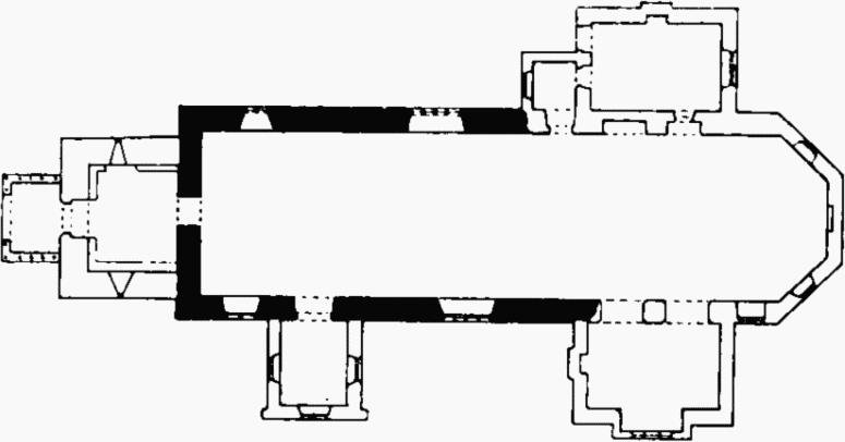
Rotherwas Chapel, Plan
Architectural Description—The Nave (53 ft. by 19¼ ft.) has in the N. wall two windows, the eastern perhaps of the 14th century and of four trefoiled lights in a square head with a moulded label; the western window is of two lights, much restored and perhaps of 14th-century origin. In the S. wall are two windows similar to the corresponding windows in the N. wall; the 16th-century S. doorway has chamfered jambs and four-centred head.
The West Tower (9¾ ft. by 10½ ft. originally) has been re-built except for the lower parts of the walls, where portions of the thicker walls of the earlier building were retained. The 16th-century doorway in the E. wall has a segmental head. The W. doorway is modern.
The Roof (Plate 88) of the nave is of late 16th-century date and of four bays with moulded main timbers, tie-beams supporting side-posts, hammer-beams on the side-posts with curved braces and secondary side-posts below the collars; the secondary side-posts and the middle of the collars have moulded pendants. On the W. face of the western tie-beam is the inscription "Tho. scd. filius Rogeri Bodenham Arm. natus fuit anno dm. 1589 Octobris 18."
Condition—Recently restored and now in charge of H.M. Office of Works.
Secular
b(3). Cottage, about 380 yards E.N.E. of church, is a 17th-century building of two storeys, timber-framed and plastered with some brick nogging; the roof is covered with corrugated iron.
Condition—Fairly good.
b(4). Cottage, 100 yards N. of church, is of late 17th-century date. It is of two storeys, timber-framed and plastered, on stone foundations; the roof is covered with corrugated iron.
Condition—Good.
b(5). Cottage, about ¼ m. N. of church, is of early 17th-century date. It is of two storeys, timber-framed and plastered with brick nogging; the roof is covered with corrugated iron.
Condition—Good.
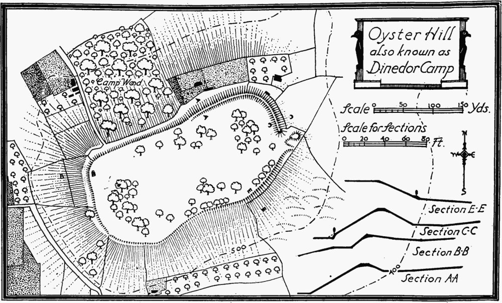
Oyster Hill, also known as Dinedor Camp
Unclassified
a(6). Oyster Hill or Dinedor Camp, contourcamp, on the top of Dinedor Hill, ¾ m. W.S.W. of the church, is of elongated oval form, approximately 9½ acres in area internally. The defences consist of a rampart towards the N.E., 7–14 ft. high above the internal level, and a scarp (Plate 1) and berm towards the N.W. and W., which side is further protected by a steep natural slope; the same slope forms the only defence on most of the S. side, but towards the E. end there is a scarp in addition. The entrance is at the extreme E. end, and outside it are traces of a mound or bank which may represent the original traverse covering it.
Condition—Good.
b(7). Earthworks, in field, called Garrison Meadow, immediately S.W. of the church, consist of a series of slight banks and ditches and two sinkings divided by a bank. They perhaps represent a village site.
Condition—Bad.